

Landmark
Encyclopedia
This is a list of landmark
s around the world.
Landmarks may be split into two categories - natural phenomena (physical features such as waterfalls, rivers, mountains and rock formations) and man-made features, like buildings, bridges, statues, public squares and so forth. This list includes natural phenomena by country, followed by man-made features by continent and by country.
.jpg)


Landmark
This is a list of landmarks around the world.Landmarks may be split into two categories - natural phenomena and man-made features, like buildings, bridges, statues, public squares and so forth...
s around the world.
Landmarks may be split into two categories - natural phenomena (physical features such as waterfalls, rivers, mountains and rock formations) and man-made features, like buildings, bridges, statues, public squares and so forth. This list includes natural phenomena by country, followed by man-made features by continent and by country.
Antarctica
- Ross Ice ShelfRoss Ice ShelfThe Ross Ice Shelf is the largest ice shelf of Antarctica . It is several hundred metres thick. The nearly vertical ice front to the open sea is more than 600 km long, and between 15 and 50 metres high above the water surface...
with McMurdo Ice ShelfMcMurdo Ice ShelfMcMurdo Ice Shelf is the portion of the Ross Ice Shelf bounded by McMurdo Sound and Ross Island on the north and Minna Bluff on the south. Studies show this feature has characteristics quite distinct from the Ross Ice Shelf and merits individual naming. A.J...
, Ross DependencyRoss DependencyThe Ross Dependency is a region of Antarctica defined by a sector originating at the South Pole, passing along longitudes 160° east to 150° west, and terminating at latitude 60° south...
, Antarctica - Ross IslandRoss IslandRoss Island is an island formed by four volcanoes in the Ross Sea near the continent of Antarctica, off the coast of Victoria Land in McMurdo Sound.-Geography:...
with Mount ErebusMount ErebusMount Erebus in Antarctica is the southernmost historically active volcano on Earth, the second highest volcano in Antarctica , and the 6th highest ultra mountain on an island. With a summit elevation of , it is located on Ross Island, which is also home to three inactive volcanoes, notably Mount...
and Mount TerrorMount Terror (Antarctica)Mount Terror is a large shield volcano that forms the eastern part of Ross Island, Antarctica. It has numerous cinder cones and domes on the flanks of the shield and is mostly under snow and ice. It is the second largest of the four volcanoes which make up Ross Island and is somewhat overshadowed...
, Ross DependencyRoss DependencyThe Ross Dependency is a region of Antarctica defined by a sector originating at the South Pole, passing along longitudes 160° east to 150° west, and terminating at latitude 60° south...
, Antarctica
Argentina
- Iguazu FallsIguazu FallsIguazu Falls, Iguassu Falls, or Iguaçu Falls are waterfalls of the Iguazu River located on the border of the Brazilian State of Paraná and the Argentine Province of Misiones. The falls divide the river into the upper and lower Iguazu. The Iguazu River originates near the city of Curitiba. It flows...
, MisionesMisiones ProvinceMisiones is one of the 23 provinces of Argentina, located in the northeastern corner of the country in the Mesopotamiсa region. It is surrounded by Paraguay to the northwest, Brazil to the north, east and south, and Corrientes Province of Argentina to the southwest.- History :The province was...
/ParanáParaná (state)Paraná is one of the states of Brazil, located in the South of the country, bordered on the north by São Paulo state, on the east by the Atlantic Ocean, on the south by Santa Catarina state and the Misiones Province of Argentina, and on the west by Mato Grosso do Sul and the republic of Paraguay,...
, Brazil/Argentina - Los Glaciares National ParkLos Glaciares National ParkParque Nacional Los Glaciares is a national park in the Santa Cruz Province, in Argentine Patagonia. It comprises an area of 4459 km². In 1981 it was declared a World Heritage Site by UNESCO....
with Perito Moreno GlacierPerito Moreno GlacierThe Perito Moreno Glacier is a glacier located in the Los Glaciares National Park in the south west of Santa Cruz province, Argentina. It is one of the most important tourist attractions in the Argentine Patagonia....
, Santa CruzSanta Cruz Province (Argentina)Santa Cruz is a province of Argentina, located in the southern part of the country, in Patagonia. It borders Chubut province to the north, and Chile to the west and south. To the east is the Atlantic Ocean... - Mount Fitz Roy, Santa CruzSanta Cruz Province (Argentina)Santa Cruz is a province of Argentina, located in the southern part of the country, in Patagonia. It borders Chubut province to the north, and Chile to the west and south. To the east is the Atlantic Ocean...
/Magallanes, ArgentinaArgentinaArgentina , officially the Argentine Republic , is the second largest country in South America by land area, after Brazil. It is constituted as a federation of 23 provinces and an autonomous city, Buenos Aires...
/ChileChileChile ,officially the Republic of Chile , is a country in South America occupying a long, narrow coastal strip between the Andes mountains to the east and the Pacific Ocean to the west. It borders Peru to the north, Bolivia to the northeast, Argentina to the east, and the Drake Passage in the far...
Australia
- Boodjamulla National ParkBoodjamulla National ParkBoodjamulla National Park, formerly known as Lawn Hill National Park, is a national park in the Gulf Country region of northwestern Queensland, Australia. The park is northwest of Mount Isa or northwest of Brisbane....
with RiversleighRiversleighRiversleigh, in North West Queensland, is Australia's most famous fossil site. The 100 km² area has fossil remains of ancient mammals, birds and reptiles of Oligocene and Miocene age...
, QueenslandQueenslandQueensland is a state of Australia, occupying the north-eastern section of the mainland continent. It is bordered by the Northern Territory, South Australia and New South Wales to the west, south-west and south respectively. To the east, Queensland is bordered by the Coral Sea and Pacific Ocean... - Barron Gorge National ParkBarron Gorge National ParkBarron Gorge National Park is a national park in Queensland , 1,404 km northwest of Brisbane and 2 km from Kuranda. Barron Gorge is part of the Wet Tropics World Heritage Area. The Kuranda Scenic Railway line passes through the park with a station at Barron Falls. One train runs from...
, Wet Tropics of QueenslandWet Tropics of QueenslandThe Wet Tropics of Queensland World Heritage Site consists of approximately 8,940 km² of Australian wet tropical forests growing along the north-east Queensland portion of the Great Dividing Range, stretching from Townsville to Cooktown, running in close parallel to the Great Barrier Reef...
, QueenslandQueenslandQueensland is a state of Australia, occupying the north-eastern section of the mainland continent. It is bordered by the Northern Territory, South Australia and New South Wales to the west, south-west and south respectively. To the east, Queensland is bordered by the Coral Sea and Pacific Ocean... - Cedar Bay National ParkCedar Bay National ParkCedar Bay is a national park in Queensland, Australia, northwest of Brisbane, south of Cooktown and accessible only by boat or foot. The park is one of the Wet Tropics World Heritage Area series of national parks, and is a gazetted World Heritage site. It is also known as Mangkal-Mangkalba in...
, Wet Tropics of QueenslandWet Tropics of QueenslandThe Wet Tropics of Queensland World Heritage Site consists of approximately 8,940 km² of Australian wet tropical forests growing along the north-east Queensland portion of the Great Dividing Range, stretching from Townsville to Cooktown, running in close parallel to the Great Barrier Reef...
, QueenslandQueenslandQueensland is a state of Australia, occupying the north-eastern section of the mainland continent. It is bordered by the Northern Territory, South Australia and New South Wales to the west, south-west and south respectively. To the east, Queensland is bordered by the Coral Sea and Pacific Ocean... - Daintree National ParkDaintree National ParkDaintree is a national park in Far North Queensland, Australia, northwest of Brisbane and northwest of Cairns. It was founded in 1981 and is part of the Wet Tropics of Queensland. In 1988 it was granted listing as a World Heritage List...
, Wet Tropics of QueenslandWet Tropics of QueenslandThe Wet Tropics of Queensland World Heritage Site consists of approximately 8,940 km² of Australian wet tropical forests growing along the north-east Queensland portion of the Great Dividing Range, stretching from Townsville to Cooktown, running in close parallel to the Great Barrier Reef...
, QueenslandQueenslandQueensland is a state of Australia, occupying the north-eastern section of the mainland continent. It is bordered by the Northern Territory, South Australia and New South Wales to the west, south-west and south respectively. To the east, Queensland is bordered by the Coral Sea and Pacific Ocean... - Girringun National ParkGirringun National ParkGirrungun National Park is a National Park in Queensland , approximately 50 km southwest of Ingham, 110 km north of Townsville and 1,290 km northwest of Brisbane. The park was formerly named Lumholtz National Park when it was created in 1994. The Blencoe Falls Section was gazetted as...
, Wet Tropics of QueenslandWet Tropics of QueenslandThe Wet Tropics of Queensland World Heritage Site consists of approximately 8,940 km² of Australian wet tropical forests growing along the north-east Queensland portion of the Great Dividing Range, stretching from Townsville to Cooktown, running in close parallel to the Great Barrier Reef...
, QueenslandQueenslandQueensland is a state of Australia, occupying the north-eastern section of the mainland continent. It is bordered by the Northern Territory, South Australia and New South Wales to the west, south-west and south respectively. To the east, Queensland is bordered by the Coral Sea and Pacific Ocean... - Wooroonooran National ParkWooroonooran National ParkWooroonooran is a national park in Queensland , 1367 km northwest of Brisbane, between Innisfail and Cairns.The park is one of the Wet Tropics World Heritage Area series of national parks, and is a gazetted World Heritage site...
, Wet Tropics of QueenslandWet Tropics of QueenslandThe Wet Tropics of Queensland World Heritage Site consists of approximately 8,940 km² of Australian wet tropical forests growing along the north-east Queensland portion of the Great Dividing Range, stretching from Townsville to Cooktown, running in close parallel to the Great Barrier Reef...
, QueenslandQueenslandQueensland is a state of Australia, occupying the north-eastern section of the mainland continent. It is bordered by the Northern Territory, South Australia and New South Wales to the west, south-west and south respectively. To the east, Queensland is bordered by the Coral Sea and Pacific Ocean...
- Great Barrier ReefGreat Barrier ReefThe Great Barrier Reef is the world'slargest reef system composed of over 2,900 individual reefs and 900 islands stretching for over 2,600 kilometres over an area of approximately...
, Coral SeaCoral SeaThe Coral Sea is a marginal sea off the northeast coast of Australia. It is bounded in the west by the east coast of Queensland, thereby including the Great Barrier Reef, in the east by Vanuatu and by New Caledonia, and in the north approximately by the southern extremity of the Solomon Islands...
, QueenslandQueenslandQueensland is a state of Australia, occupying the north-eastern section of the mainland continent. It is bordered by the Northern Territory, South Australia and New South Wales to the west, south-west and south respectively. To the east, Queensland is bordered by the Coral Sea and Pacific Ocean... - Fraser Island, QueenslandQueenslandQueensland is a state of Australia, occupying the north-eastern section of the mainland continent. It is bordered by the Northern Territory, South Australia and New South Wales to the west, south-west and south respectively. To the east, Queensland is bordered by the Coral Sea and Pacific Ocean...
- Lamington National ParkLamington National ParkLamington is a national park in Queensland, Australia, lying on the Lamington Plateau of the McPherson Range on the Queensland/New South Wales border...
, Gondwana Rainforests, QueenslandQueenslandQueensland is a state of Australia, occupying the north-eastern section of the mainland continent. It is bordered by the Northern Territory, South Australia and New South Wales to the west, south-west and south respectively. To the east, Queensland is bordered by the Coral Sea and Pacific Ocean... - Mount Chinghee National ParkMount Chinghee National ParkMount Chinghee is a national park in Queensland, Australia, 93 km south of Brisbane. It is part of the Shield Volcano Group of the World Heritage Site Gondwana Rainforests of Australia inscribed in 1986 and added to the Australian National Heritage List in 2007...
, Gondwana Rainforests, QueenslandQueenslandQueensland is a state of Australia, occupying the north-eastern section of the mainland continent. It is bordered by the Northern Territory, South Australia and New South Wales to the west, south-west and south respectively. To the east, Queensland is bordered by the Coral Sea and Pacific Ocean... - Springbrook National ParkSpringbrook National ParkSpringbrook National Park is a national park at Springbrook on the McPherson Range in the Gold Coast hinterland of Queensland, , 96 km south of Brisbane. It is part of the Shield Volcano Group of the World Heritage site Gondwana Rainforests of Australia...
, Gondwana Rainforests, QueenslandQueenslandQueensland is a state of Australia, occupying the north-eastern section of the mainland continent. It is bordered by the Northern Territory, South Australia and New South Wales to the west, south-west and south respectively. To the east, Queensland is bordered by the Coral Sea and Pacific Ocean... - Mount Barney National ParkMount Barney National ParkMount Barney National Park is a national park in Queensland , 90 km southwest of Brisbane. It amalgamated the adjacent Mount Lindesay National Park in 1980. It is part of the Scenic Rim Important Bird Area, identified as such by BirdLife International because of its importance in the conservation...
, Gondwana Rainforests, QueenslandQueenslandQueensland is a state of Australia, occupying the north-eastern section of the mainland continent. It is bordered by the Northern Territory, South Australia and New South Wales to the west, south-west and south respectively. To the east, Queensland is bordered by the Coral Sea and Pacific Ocean... - Main Range National ParkMain Range National ParkMain Range is a mountain range and a national park in Queensland , 85 km southwest of Brisbane. It is part of the World Heritage Site Gondwana Rainforests of Australia . It protects the western part of a semicircle of mountains in South East Queensland known as the Scenic Rim...
, Gondwana Rainforests, QueenslandQueenslandQueensland is a state of Australia, occupying the north-eastern section of the mainland continent. It is bordered by the Northern Territory, South Australia and New South Wales to the west, south-west and south respectively. To the east, Queensland is bordered by the Coral Sea and Pacific Ocean... - Barrington Tops National ParkBarrington Tops National ParkBarrington Tops is a National Park in the Hunter Valley, approximately north of Sydney in New South Wales, Australia. The nearest towns are Scone, Singleton, Dungog, Gloucester and East Gresford....
, Gondwana Rainforests, New South WalesNew South WalesNew South Wales is a state of :Australia, located in the east of the country. It is bordered by Queensland, Victoria and South Australia to the north, south and west respectively. To the east, the state is bordered by the Tasman Sea, which forms part of the Pacific Ocean. New South Wales... - Dorrigo National ParkDorrigo National ParkDorrigo National Park is a national park in New South Wales , 580 km north of Sydney on Dome Road off the Waterfall Way, 5 km east of the town of Dorrigo....
, Gondwana Rainforests, New South WalesNew South WalesNew South Wales is a state of :Australia, located in the east of the country. It is bordered by Queensland, Victoria and South Australia to the north, south and west respectively. To the east, the state is bordered by the Tasman Sea, which forms part of the Pacific Ocean. New South Wales... - Mount Warning National ParkMount Warning National ParkMount Warning National Park is a park in northern New South Wales, Australia, 642 km north of Sydney near the border with the state of Queensland. It surrounds Mount Warning, part of a remnant caldera of a much larger extinct volcano . The park is administered by the NSW National Parks and...
, Gondwana Rainforests, New South WalesNew South WalesNew South Wales is a state of :Australia, located in the east of the country. It is bordered by Queensland, Victoria and South Australia to the north, south and west respectively. To the east, the state is bordered by the Tasman Sea, which forms part of the Pacific Ocean. New South Wales... - New England National ParkNew England National ParkNew England National Park is situated on the Northern Tablelands in the New England region of New South Wales, Australia, 560 km north of Sydney. It is about 10 km south of Waterfall Way, just 85 km east of Armidale and 65 km west of Coffs Harbour...
, Gondwana Rainforests, New South WalesNew South WalesNew South Wales is a state of :Australia, located in the east of the country. It is bordered by Queensland, Victoria and South Australia to the north, south and west respectively. To the east, the state is bordered by the Tasman Sea, which forms part of the Pacific Ocean. New South Wales... - Oxley Wild Rivers National ParkOxley Wild Rivers National ParkOxley Wild Rivers National Park is in New South Wales, Australia, 445 kilometres north of Sydney and is named in memory of the Australian explorer John Oxley, who passed through the area in 1818...
, Gondwana Rainforests, New South WalesNew South WalesNew South Wales is a state of :Australia, located in the east of the country. It is bordered by Queensland, Victoria and South Australia to the north, south and west respectively. To the east, the state is bordered by the Tasman Sea, which forms part of the Pacific Ocean. New South Wales... - Washpool National ParkWashpool National ParkThe Washpool National Park is a national park in New South Wales, Australia, 516 km north of Sydney. The park is 586.78 km2 in size, has two campgrounds and is managed by the New South Wales National Parks and Wildlife Service...
, Gondwana Rainforests, New South WalesNew South WalesNew South Wales is a state of :Australia, located in the east of the country. It is bordered by Queensland, Victoria and South Australia to the north, south and west respectively. To the east, the state is bordered by the Tasman Sea, which forms part of the Pacific Ocean. New South Wales... - Willi Willi National ParkWilli Willi National ParkWilli Willi is a national park in New South Wales, Australia, 325 km northeast of Sydney. It is quite noticeable from nearby Port Macquarie as a tall escarpment to the north west...
, Gondwana Rainforests, New South WalesNew South WalesNew South Wales is a state of :Australia, located in the east of the country. It is bordered by Queensland, Victoria and South Australia to the north, south and west respectively. To the east, the state is bordered by the Tasman Sea, which forms part of the Pacific Ocean. New South Wales... - Werrikimbe National ParkWerrikimbe National ParkWerrikimbe National Park is in the catchment zone of the Upper Hastings River, New South Wales, Australia, about 486 km north of Sydney. This national park is about 80 km west of Wauchope and 90 km east of Walcha on the eastern escarpment of the Great Dividing Range...
, Gondwana Rainforests, New South WalesNew South WalesNew South Wales is a state of :Australia, located in the east of the country. It is bordered by Queensland, Victoria and South Australia to the north, south and west respectively. To the east, the state is bordered by the Tasman Sea, which forms part of the Pacific Ocean. New South Wales... - Three SistersThree Sisters (Australia)The Three Sisters is a rock formation in the Blue Mountains of New South Wales, Australia. They are close to the town of Katoomba and are one of the Blue Mountains' best known sites, towering above the Jamison Valley. Their names are Meehni , Wimlah , and Gunnedoo .-Geology:The Sisters were formed...
, Blue Mountains, New South WalesNew South WalesNew South Wales is a state of :Australia, located in the east of the country. It is bordered by Queensland, Victoria and South Australia to the north, south and west respectively. To the east, the state is bordered by the Tasman Sea, which forms part of the Pacific Ocean. New South Wales... - Lord Howe Island GroupLord Howe IslandLord Howe Island is an irregularly crescent-shaped volcanic remnant in the Tasman Sea between Australia and New Zealand, directly east of mainland Port Macquarie, and about from Norfolk Island. The island is about 11 km long and between 2.8 km and 0.6 km wide with an area of...
, New South WalesNew South WalesNew South Wales is a state of :Australia, located in the east of the country. It is bordered by Queensland, Victoria and South Australia to the north, south and west respectively. To the east, the state is bordered by the Tasman Sea, which forms part of the Pacific Ocean. New South Wales... - Willandra Lakes RegionWillandra Lakes RegionThe Willandra Lakes Region is a World Heritage Site that covers 2,400 square kilometres in south-western New South Wales, Australia.The Region contains important natural and cultural features including exceptional examples of past human civilization including the world's oldest cremation site...
, New South WalesNew South WalesNew South Wales is a state of :Australia, located in the east of the country. It is bordered by Queensland, Victoria and South Australia to the north, south and west respectively. To the east, the state is bordered by the Tasman Sea, which forms part of the Pacific Ocean. New South Wales... - Port Campbell National ParkPort Campbell National ParkPort Campbell is a national park in Victoria, Australia, 190 kilometres south-west of Melbourne.-Features:The Port Campbell National Park is a protected national park in Victoria, Australia, 190 kilometres south-west of Melbourne; featuring an array of sheer cliffs overlooking offshore...
with Twelve Apostles, VictoriaVictoria (Australia)Victoria is the second most populous state in Australia. Geographically the smallest mainland state, Victoria is bordered by New South Wales, South Australia, and Tasmania on Boundary Islet to the north, west and south respectively.... - Grampians National ParkGrampians National ParkThe Grampians National Park is a national park in Victoria, Australia, 235 kilometres west of Melbourne. The Park was listed on the Australian National Heritage List on 15 December 2006 for its outstanding natural beauty and being one of the richest indigenous rock art sites in south-eastern...
, VictoriaVictoria (Australia)Victoria is the second most populous state in Australia. Geographically the smallest mainland state, Victoria is bordered by New South Wales, South Australia, and Tasmania on Boundary Islet to the north, west and south respectively.... - Cradle Mountain-Lake St Clair National ParkCradle Mountain-Lake St Clair National ParkCradle Mountain-Lake St Clair National Park is located in the Central Highlands area of Tasmania , 165 km northwest of Hobart. The park contains many walking trails, and is where hikes along the well-known Overland Track usually begins...
, Tasmanian WildernessTasmanian WildernessThe Tasmanian Wilderness is a term that is used for a range of areas in Tasmania, Australia.The World Heritage Areas in South West, Western and Central are the most well known. However, there are also other areas in Tasmania that have the elements of being known as wilderness areas, the Tarkine...
, TasmaniaTasmaniaTasmania is an Australian island and state. It is south of the continent, separated by Bass Strait. The state includes the island of Tasmania—the 26th largest island in the world—and the surrounding islands. The state has a population of 507,626 , of whom almost half reside in the greater Hobart... - Franklin-Gordon Wild Rivers National ParkFranklin-Gordon Wild Rivers National ParkFranklin-Gordon Wild Rivers is a national park in Tasmania, Australia, 117 km west of Hobart. It is named after the two main river systems lying within the bounds of the park - the Franklin River and the Gordon River.- Location :...
, Tasmanian WildernessTasmanian WildernessThe Tasmanian Wilderness is a term that is used for a range of areas in Tasmania, Australia.The World Heritage Areas in South West, Western and Central are the most well known. However, there are also other areas in Tasmania that have the elements of being known as wilderness areas, the Tarkine...
, TasmaniaTasmaniaTasmania is an Australian island and state. It is south of the continent, separated by Bass Strait. The state includes the island of Tasmania—the 26th largest island in the world—and the surrounding islands. The state has a population of 507,626 , of whom almost half reside in the greater Hobart... - Hartz Mountains National ParkHartz Mountains National ParkHartz Mountains National Park is located in the south of Tasmania, Australia. It is one of 19 Tasmanian National Parks, and in 1989 it was included in the Tasmanian Wilderness World Heritage Area, in recognition of its natural and cultural values...
, Tasmanian WildernessTasmanian WildernessThe Tasmanian Wilderness is a term that is used for a range of areas in Tasmania, Australia.The World Heritage Areas in South West, Western and Central are the most well known. However, there are also other areas in Tasmania that have the elements of being known as wilderness areas, the Tarkine...
, TasmaniaTasmaniaTasmania is an Australian island and state. It is south of the continent, separated by Bass Strait. The state includes the island of Tasmania—the 26th largest island in the world—and the surrounding islands. The state has a population of 507,626 , of whom almost half reside in the greater Hobart... - Mole Creek Karst National ParkMole Creek Karst National ParkMole Creek Karst is a national park in Tasmania, Australia, 168 km northwest of Hobart. It is the only national park in Tasmania created specifically to protect karst landforms...
, Tasmanian WildernessTasmanian WildernessThe Tasmanian Wilderness is a term that is used for a range of areas in Tasmania, Australia.The World Heritage Areas in South West, Western and Central are the most well known. However, there are also other areas in Tasmania that have the elements of being known as wilderness areas, the Tarkine...
, TasmaniaTasmaniaTasmania is an Australian island and state. It is south of the continent, separated by Bass Strait. The state includes the island of Tasmania—the 26th largest island in the world—and the surrounding islands. The state has a population of 507,626 , of whom almost half reside in the greater Hobart... - Southwest National ParkSouthwest National ParkThe Southwest National Park is a national park located in the south-west of Tasmania, Australia. The park is Tasmania's largest and forms part of the Tasmanian Wilderness World Heritage Area....
, Tasmanian WildernessTasmanian WildernessThe Tasmanian Wilderness is a term that is used for a range of areas in Tasmania, Australia.The World Heritage Areas in South West, Western and Central are the most well known. However, there are also other areas in Tasmania that have the elements of being known as wilderness areas, the Tarkine...
, TasmaniaTasmaniaTasmania is an Australian island and state. It is south of the continent, separated by Bass Strait. The state includes the island of Tasmania—the 26th largest island in the world—and the surrounding islands. The state has a population of 507,626 , of whom almost half reside in the greater Hobart... - Walls of Jerusalem National ParkWalls of Jerusalem National ParkWalls Of Jerusalem is a national park in Tasmania, Australia, 144 km northwest of Hobart. It forms part of the Tasmanian Wilderness World Heritage Area....
, Tasmanian WildernessTasmanian WildernessThe Tasmanian Wilderness is a term that is used for a range of areas in Tasmania, Australia.The World Heritage Areas in South West, Western and Central are the most well known. However, there are also other areas in Tasmania that have the elements of being known as wilderness areas, the Tarkine...
, TasmaniaTasmaniaTasmania is an Australian island and state. It is south of the continent, separated by Bass Strait. The state includes the island of Tasmania—the 26th largest island in the world—and the surrounding islands. The state has a population of 507,626 , of whom almost half reside in the greater Hobart... - Central Plateau Conservation AreaCentral Plateau Conservation AreaThe Central Plateau conservation area is an animal & plant conservation area in Tasmania, Australia.The Central Plateau of Tasmania is the largest area of high ground in Tasmania...
, Tasmanian WildernessTasmanian WildernessThe Tasmanian Wilderness is a term that is used for a range of areas in Tasmania, Australia.The World Heritage Areas in South West, Western and Central are the most well known. However, there are also other areas in Tasmania that have the elements of being known as wilderness areas, the Tarkine...
, TasmaniaTasmaniaTasmania is an Australian island and state. It is south of the continent, separated by Bass Strait. The state includes the island of Tasmania—the 26th largest island in the world—and the surrounding islands. The state has a population of 507,626 , of whom almost half reside in the greater Hobart... - Devils Gullet State ReserveDevils Gullet State ReserveDevils Gullet is a state reserve in Tasmania, Australia. It is part of the Tasmanian Wilderness....
, Tasmanian WildernessTasmanian WildernessThe Tasmanian Wilderness is a term that is used for a range of areas in Tasmania, Australia.The World Heritage Areas in South West, Western and Central are the most well known. However, there are also other areas in Tasmania that have the elements of being known as wilderness areas, the Tarkine...
, TasmaniaTasmaniaTasmania is an Australian island and state. It is south of the continent, separated by Bass Strait. The state includes the island of Tasmania—the 26th largest island in the world—and the surrounding islands. The state has a population of 507,626 , of whom almost half reside in the greater Hobart... - Naracoorte Caves National ParkNaracoorte Caves National ParkNaracoorte Caves is a national park near Naracoorte in the Limestone Coast tourism region in the south-east of South Australia . It was officially recognised in 1994 for its extensive fossil record when the site was inscribed on the World Heritage List, along with Riversleigh...
, Limestone CoastLimestone CoastThe Limestone Coast is a name used since the early twentyfirst century for the geographical region and tourist region of the southeast coast of South Australia from the Victoria border to the towards the city of Adelaide.-Location and description:...
, South AustraliaSouth AustraliaSouth Australia is a state of Australia in the southern central part of the country. It covers some of the most arid parts of the continent; with a total land area of , it is the fourth largest of Australia's six states and two territories.South Australia shares borders with all of the mainland...
- Uluru-Kata Tjuta National ParkUluru-Kata Tjuta National ParkUluṟu-Kata Tjuṯa National Park is UNESCO World Heritage-listed in the Northern Territory of Australia. It is located 1431 kilometres south of Darwin by road and 440 kilometres south-west of Alice Springs along the Stuart and Lasseter Highways...
with UluruUluruUluru , also known as Ayers Rock, is a large sandstone rock formation in the southern part of the Northern Territory, central Australia. It lies south west of the nearest large town, Alice Springs; by road. Kata Tjuta and Uluru are the two major features of the Uluṟu-Kata Tjuṯa National Park....
, Northern TerritoryNorthern TerritoryThe Northern Territory is a federal territory of Australia, occupying much of the centre of the mainland continent, as well as the central northern regions... - Devils Marbles Conservation Reserve, Northern TerritoryNorthern TerritoryThe Northern Territory is a federal territory of Australia, occupying much of the centre of the mainland continent, as well as the central northern regions...
- Kakadu National ParkKakadu National ParkKakadu National Park is in the Northern Territory of Australia, 171 km southeast of Darwin.Kakadu National Park is located within the Alligator Rivers Region of the Northern Territory of Australia. It covers an area of , extending nearly 200 kilometres from north to south and over 100 kilometres...
, Northern TerritoryNorthern TerritoryThe Northern Territory is a federal territory of Australia, occupying much of the centre of the mainland continent, as well as the central northern regions... - Purnululu National ParkPurnululu National ParkPurnululu National Park is a national park in the Kimberley region of Western Australia. It was declared a World Heritage Site in 2003.-Location:...
, Western AustraliaWestern AustraliaWestern Australia is a state of Australia, occupying the entire western third of the Australian continent. It is bounded by the Indian Ocean to the north and west, the Great Australian Bight and Indian Ocean to the south, the Northern Territory to the north-east and South Australia to the south-east... - Shark BayShark Bay, Western AustraliaShark Bay is a World Heritage Site in the Gascoyne region of Western Australia. It is an area centred approximately on , 800 kilometres north of Perth, on the westernmost point of Australia. An expedition led by Dirk Hartog happened upon the area in 1616, becoming the second group of Europeans...
- Nambung National ParkNambung National ParkNambung National Park is a national park in the Wheatbelt region of Western Australia , 162 km northwest of Perth. It contains the Pinnacles Desert....
with Pinnacles DesertThe Pinnacles DesertThe Pinnacles are limestone formations contained within Nambung National Park, near the town of Cervantes, Western Australia.-Formation:The raw material for the limestone of the Pinnacles came from seashells in an earlier epoch rich in marine life...
, Western AustraliaWestern AustraliaWestern Australia is a state of Australia, occupying the entire western third of the Australian continent. It is bounded by the Indian Ocean to the north and west, the Great Australian Bight and Indian Ocean to the south, the Northern Territory to the north-east and South Australia to the south-east... - Wave RockWave RockWave Rock is a natural rock formation located east of the small town of Hyden in Western Australia that is shaped like a tall breaking ocean wave.Wave Rock has cultural significance to Aborigines...
, HydenHyden, Western AustraliaThe town of Hyden is located 339 km east of Perth, Western Australia in the Shire of Kondinin. Hyden is home to Wave Rock and Mulka's Cave, both popular local tourist attractions.... - Heard Island and McDonald IslandsHeard Island and McDonald IslandsThe Heard Island and McDonald Islands are an Australian external territory and volcanic group of barren Antarctic islands, about two-thirds of the way from Madagascar to Antarctica. The group's overall size is in area and it has of coastline...
- Macquarie IslandMacquarie IslandMacquarie Island lies in the southwest corner of the Pacific Ocean, about half-way between New Zealand and Antarctica, at 54°30S, 158°57E. Politically, it has formed part of the Australian state of Tasmania since 1900 and became a Tasmanian State Reserve in 1978. In 1997 it became a world heritage...
Belize
- Belize Barrier ReefBelize Barrier ReefThe Belize Barrier Reef is a series of coral reefs straddling the coast of Belize, roughly offshore in the north and in the south within the country limits...
with Hol Chan Marine ReserveHol Chan Marine ReserveHol Chan Marine Reserve is a marine reserve close to Ambergris Caye and Caye Caulker, off the coast of Belize. It covers approximately 18 km² of coral reefs, seagrass beds, and mangrove forest...
and Great Blue HoleGreat Blue HoleThe Great Blue Hole is a large submarine sinkhole off the coast of Belize. It lies near the center of Lighthouse Reef, a small atoll from the mainland and Belize City. The hole is circular in shape, over across and deep...
, Belize - Chiquibul National ParkChiquibul National ParkChiquibul National Park is Belize's largest national park. It is in size. The park is located in Belize's Cayo District. The national park surrounds Caracol, a Mayan city. Caracol has been designated as an archaeological reserve and is not included within the park's total area...
, CayoCayo DistrictCayo District is a district in the west of the nation of Belize. The District capital is the town of San Ignacio.- Geography :The Cayo District is the largest district in Belize. It is located on the western side of the country which borders Guatemala. The nation's capital, Belmopan, is... - Guanacaste National ParkGuanacaste National Park (Belize)Guanacaste National Park is a park in central Belize. It is named after a huge Guanacaste tree that escaped being logged because its trunk divided into three bases, reducing its value as timber....
, CayoCayo DistrictCayo District is a district in the west of the nation of Belize. The District capital is the town of San Ignacio.- Geography :The Cayo District is the largest district in Belize. It is located on the western side of the country which borders Guatemala. The nation's capital, Belmopan, is... - Mountain Pine Ridge Forest ReserveMountain Pine Ridge Forest ReserveMountain Pine Ridge Forest Reserve is a nature reserve in the Cayo District of southern central Belize. It was established in 1944 to protect and manage the native pine forest...
, CayoCayo DistrictCayo District is a district in the west of the nation of Belize. The District capital is the town of San Ignacio.- Geography :The Cayo District is the largest district in Belize. It is located on the western side of the country which borders Guatemala. The nation's capital, Belmopan, is... - Big Rock FallsBig Rock FallsBig Rock Falls is a 150-foot waterfall on Privassion River, in the Mountain Pine Ridge Forest Reserve of the Cayo District of southern central Belize....
, CayoCayo DistrictCayo District is a district in the west of the nation of Belize. The District capital is the town of San Ignacio.- Geography :The Cayo District is the largest district in Belize. It is located on the western side of the country which borders Guatemala. The nation's capital, Belmopan, is... - Rio Bravo Conservation and Management AreaRio Bravo Conservation and Management AreaRio Bravo Conservation and Management Area is a nature reserve located in northwestern Belize. Rio Bravo, as it is known, was established by Programme for Belize in 1988 with the purchase of 110,044 acres of land from Gallon Jug Agroindustries. With logging encroachment imminent in 1989, the...
, Orange WalkOrange Walk DistrictOrange Walk District is a district in the northwest of the nation of Belize, with its district capital in Orange Walk Town.- Main settlements :... - Cockscomb Basin Wildlife SanctuaryCockscomb Basin Wildlife SanctuaryThe Cockscomb Basin Wildlife Sanctuary is a nature reserve in south-central Belize established to protect the forests, fauna and watersheds of an approximately 400 square kilometre area of the eastern slopes of the Maya Mountains...
, Stann CreekStann Creek DistrictStann Creek District is a district in the south east region of Belize. According to the 2010 census, the district had a population of 32,166 people...
Bolivia
- Amazon RiverAmazon RiverThe Amazon of South America is the second longest river in the world and by far the largest by waterflow with an average discharge greater than the next seven largest rivers combined...
, BoliviaBoliviaBolivia officially known as Plurinational State of Bolivia , is a landlocked country in central South America. It is the poorest country in South America...
/BrazilBrazilBrazil , officially the Federative Republic of Brazil , is the largest country in South America. It is the world's fifth largest country, both by geographical area and by population with over 192 million people...
/ColombiaColombiaColombia, officially the Republic of Colombia , is a unitary constitutional republic comprising thirty-two departments. The country is located in northwestern South America, bordered to the east by Venezuela and Brazil; to the south by Ecuador and Peru; to the north by the Caribbean Sea; to the...
/EcuadorEcuadorEcuador , officially the Republic of Ecuador is a representative democratic republic in South America, bordered by Colombia on the north, Peru on the east and south, and by the Pacific Ocean to the west. It is one of only two countries in South America, along with Chile, that do not have a border...
/GuyanaGuyanaGuyana , officially the Co-operative Republic of Guyana, previously the colony of British Guiana, is a sovereign state on the northern coast of South America that is culturally part of the Anglophone Caribbean. Guyana was a former colony of the Dutch and of the British...
/PeruPeruPeru , officially the Republic of Peru , is a country in western South America. It is bordered on the north by Ecuador and Colombia, on the east by Brazil, on the southeast by Bolivia, on the south by Chile, and on the west by the Pacific Ocean....
/VenezuelaVenezuelaVenezuela , officially called the Bolivarian Republic of Venezuela , is a tropical country on the northern coast of South America. It borders Colombia to the west, Guyana to the east, and Brazil to the south...
Brazil
- Amazon RiverAmazon RiverThe Amazon of South America is the second longest river in the world and by far the largest by waterflow with an average discharge greater than the next seven largest rivers combined...
, BrazilBrazilBrazil , officially the Federative Republic of Brazil , is the largest country in South America. It is the world's fifth largest country, both by geographical area and by population with over 192 million people...
/BoliviaBoliviaBolivia officially known as Plurinational State of Bolivia , is a landlocked country in central South America. It is the poorest country in South America...
/ColombiaColombiaColombia, officially the Republic of Colombia , is a unitary constitutional republic comprising thirty-two departments. The country is located in northwestern South America, bordered to the east by Venezuela and Brazil; to the south by Ecuador and Peru; to the north by the Caribbean Sea; to the...
/EcuadorEcuadorEcuador , officially the Republic of Ecuador is a representative democratic republic in South America, bordered by Colombia on the north, Peru on the east and south, and by the Pacific Ocean to the west. It is one of only two countries in South America, along with Chile, that do not have a border...
/GuyanaGuyanaGuyana , officially the Co-operative Republic of Guyana, previously the colony of British Guiana, is a sovereign state on the northern coast of South America that is culturally part of the Anglophone Caribbean. Guyana was a former colony of the Dutch and of the British...
/PeruPeruPeru , officially the Republic of Peru , is a country in western South America. It is bordered on the north by Ecuador and Colombia, on the east by Brazil, on the southeast by Bolivia, on the south by Chile, and on the west by the Pacific Ocean....
/VenezuelaVenezuelaVenezuela , officially called the Bolivarian Republic of Venezuela , is a tropical country on the northern coast of South America. It borders Colombia to the west, Guyana to the east, and Brazil to the south... - Iguazu FallsIguazu FallsIguazu Falls, Iguassu Falls, or Iguaçu Falls are waterfalls of the Iguazu River located on the border of the Brazilian State of Paraná and the Argentine Province of Misiones. The falls divide the river into the upper and lower Iguazu. The Iguazu River originates near the city of Curitiba. It flows...
, ParanáParaná (state)Paraná is one of the states of Brazil, located in the South of the country, bordered on the north by São Paulo state, on the east by the Atlantic Ocean, on the south by Santa Catarina state and the Misiones Province of Argentina, and on the west by Mato Grosso do Sul and the republic of Paraguay,...
/MisionesMisiones ProvinceMisiones is one of the 23 provinces of Argentina, located in the northeastern corner of the country in the Mesopotamiсa region. It is surrounded by Paraguay to the northwest, Brazil to the north, east and south, and Corrientes Province of Argentina to the southwest.- History :The province was...
, BrazilBrazilBrazil , officially the Federative Republic of Brazil , is the largest country in South America. It is the world's fifth largest country, both by geographical area and by population with over 192 million people...
/ArgentinaArgentinaArgentina , officially the Argentine Republic , is the second largest country in South America by land area, after Brazil. It is constituted as a federation of 23 provinces and an autonomous city, Buenos Aires... - Lençóis Maranhenses National ParkLençóis Maranhenses National ParkThe Lençóis Maranhenses National Park is located in Maranhão state, in northeastern Brazil, just east of the Baía de São José, between 02º19’—02º45’ S and 42º44’—43º29’ W. It is an area of low, flat, occasionally flooded land, overlaid with large, discrete sand dunes...
, MaranhãoMaranhãoMaranhão is a northeastern state of Brazil. To the north lies the Atlantic Ocean. Maranhão is neighbored by the states of Piauí, Tocantins and Pará. The people of Maranhão have a distinctive accent... - Chapada Diamantina National ParkChapada Diamantina National ParkThe Chapada Diamantina National Park is a 1,520 km² national park in the Chapada Diamantina region of Bahia state in the Northeast of Brazil...
, BahiaBahiaBahia is one of the 26 states of Brazil, and is located in the northeastern part of the country on the Atlantic coast. It is the fourth most populous Brazilian state after São Paulo, Minas Gerais and Rio de Janeiro, and the fifth-largest in size... - Chapada dos Guimarães National ParkChapada dos Guimarães National ParkThe Chapada dos Guimarães National Park is a national park in the Brazilian state of Mato Grosso. It is located between 15°10'- 15º30' S and 55°40' - 56°00' W....
, Mato GrossoMato GrossoMato Grosso is one of the states of Brazil, the third largest in area, located in the western part of the country.Neighboring states are Rondônia, Amazonas, Pará, Tocantins, Goiás and Mato Grosso do Sul. It also borders Bolivia to the southwest... - Pico da Neblina National ParkPico da Neblina National ParkPico da Neblina National Park is a national park in the north of Brazil, bordering on Venezuela. The latter country also has an adjoining national park, called Neblina as well. The Brazilian national park was created in 1979, and it is one of the country's largest national parks, with...
, RoraimaRoraimaRoraima is the northernmost and least populated state of Brazil, located in the Amazon region. It borders the states of Amazonas and Pará, as well as the nations of Venezuela and Guyana. The population is 400,000 and the capital is Boa Vista... - Pantanal Matogrossense National ParkPantanal Matogrossense National ParkThe Pantanal Matogrossense National Park is a national park of Brazil, in the southern state of Mato Grosso.The park is in the Pantanal, a World Heritage Site and a Ramsar Convention significant wetlands habitat. The Cuiabá River runs through Pantanal Matogrossense National Park....
, Mato GrossoMato GrossoMato Grosso is one of the states of Brazil, the third largest in area, located in the western part of the country.Neighboring states are Rondônia, Amazonas, Pará, Tocantins, Goiás and Mato Grosso do Sul. It also borders Bolivia to the southwest...
/Mato Grosso do SulMato Grosso do SulMato Grosso do Sul is one of the states of Brazil.Neighboring Brazilian states are Mato Grosso, Goiás, Minas Gerais, São Paulo and Paraná. It also borders the countries of Paraguay and Bolivia to the west. The economy of the state is largely based on agriculture and cattle-raising... - Abrolhos Marine National ParkAbrolhos Marine National ParkThe Abrolhos Marine National Park is a Marine Park located in the Abrolhos Archipelago since 1983.The Abrolhos are an archipelago of 5 islands with coral reefs off the southern coast of Bahia state in the northeast of Brazil, between 17º25’—18º09’ S and 38º33’—39º05’ W.-External links:***...
, BahiaBahiaBahia is one of the 26 states of Brazil, and is located in the northeastern part of the country on the Atlantic coast. It is the fourth most populous Brazilian state after São Paulo, Minas Gerais and Rio de Janeiro, and the fifth-largest in size... - Atol das Rocas Biological ReserveAtol das Rocas Biological ReserveAtol das Rocas Biological Reserve is a biological reserve in Brazil. The reserve is located on the Atol das Rocas, an atoll 144 miles northeast of the Brazilian coast. The Atol das Rocas Biological Reserve was created in 1979 as to protect nesting green turtles and migratory marine birds....
- Parque Estadual de Vila Velha, ParanáParaná (state)Paraná is one of the states of Brazil, located in the South of the country, bordered on the north by São Paulo state, on the east by the Atlantic Ocean, on the south by Santa Catarina state and the Misiones Province of Argentina, and on the west by Mato Grosso do Sul and the republic of Paraguay,...
Burundi
- NileNileThe Nile is a major north-flowing river in North Africa, generally regarded as the longest river in the world. It is long. It runs through the ten countries of Sudan, South Sudan, Burundi, Rwanda, Democratic Republic of the Congo, Tanzania, Kenya, Ethiopia, Uganda and Egypt.The Nile has two major...
with Blue NileBlue NileThe Blue Nile is a river originating at Lake Tana in Ethiopia. With the White Nile, the river is one of the two major tributaries of the Nile...
and White NileWhite NileThe White Nile is a river of Africa, one of the two main tributaries of the Nile from Egypt, the other being the Blue Nile. In the strict meaning, "White Nile" refers to the river formed at Lake No at the confluence of the Bahr al Jabal and Bahr el Ghazal rivers...
, BurundiBurundiBurundi , officially the Republic of Burundi , is a landlocked country in the Great Lakes region of Eastern Africa bordered by Rwanda to the north, Tanzania to the east and south, and the Democratic Republic of the Congo to the west. Its capital is Bujumbura...
/Democratic Republic of the CongoDemocratic Republic of the CongoThe Democratic Republic of the Congo is a state located in Central Africa. It is the second largest country in Africa by area and the eleventh largest in the world...
/EgyptEgyptEgypt , officially the Arab Republic of Egypt, Arabic: , is a country mainly in North Africa, with the Sinai Peninsula forming a land bridge in Southwest Asia. Egypt is thus a transcontinental country, and a major power in Africa, the Mediterranean Basin, the Middle East and the Muslim world...
/EritreaEritreaEritrea , officially the State of Eritrea, is a country in the Horn of Africa. Eritrea derives it's name from the Greek word Erethria, meaning 'red land'. The capital is Asmara. It is bordered by Sudan in the west, Ethiopia in the south, and Djibouti in the southeast...
/EthiopiaEthiopiaEthiopia , officially known as the Federal Democratic Republic of Ethiopia, is a country located in the Horn of Africa. It is the second-most populous nation in Africa, with over 82 million inhabitants, and the tenth-largest by area, occupying 1,100,000 km2...
/KenyaKenyaKenya , officially known as the Republic of Kenya, is a country in East Africa that lies on the equator, with the Indian Ocean to its south-east...
/RwandaRwandaRwanda or , officially the Republic of Rwanda , is a country in central and eastern Africa with a population of approximately 11.4 million . Rwanda is located a few degrees south of the Equator, and is bordered by Uganda, Tanzania, Burundi and the Democratic Republic of the Congo...
/SudanSudanSudan , officially the Republic of the Sudan , is a country in North Africa, sometimes considered part of the Middle East politically. It is bordered by Egypt to the north, the Red Sea to the northeast, Eritrea and Ethiopia to the east, South Sudan to the south, the Central African Republic to the...
/TanzaniaTanzaniaThe United Republic of Tanzania is a country in East Africa bordered by Kenya and Uganda to the north, Rwanda, Burundi, and the Democratic Republic of the Congo to the west, and Zambia, Malawi, and Mozambique to the south. The country's eastern borders lie on the Indian Ocean.Tanzania is a state...
/UgandaUgandaUganda , officially the Republic of Uganda, is a landlocked country in East Africa. Uganda is also known as the "Pearl of Africa". It is bordered on the east by Kenya, on the north by South Sudan, on the west by the Democratic Republic of the Congo, on the southwest by Rwanda, and on the south by...
Canada
- Aulavik National ParkAulavik National ParkAulavik National Park is a national park located on Banks Island in the Northwest Territories of Canada. It is known for its access to the Thomsen River, one of the most northerly navigable rivers in North America. The park is a fly-in park, and protects approximately of Arctic Lowlands at the...
, Northwest TerritoriesNorthwest TerritoriesThe Northwest Territories is a federal territory of Canada.Located in northern Canada, the territory borders Canada's two other territories, Yukon to the west and Nunavut to the east, and three provinces: British Columbia to the southwest, and Alberta and Saskatchewan to the south... - Auyuittuq National ParkAuyuittuq National ParkAuyuittuq National Park is a national park located on Baffin Island's Cumberland Peninsula, Qikiqtaaluk Region in Nunavut, the largest political subdivision of Canada. It features the many terrains of Arctic wilderness, such as fjords, glaciers, and ice fields...
, NunavutNunavutNunavut is the largest and newest federal territory of Canada; it was separated officially from the Northwest Territories on April 1, 1999, via the Nunavut Act and the Nunavut Land Claims Agreement Act, though the actual boundaries had been established in 1993... - Banff National ParkBanff National ParkBanff National Park is Canada's oldest national park, established in 1885 in the Rocky Mountains. The park, located 110–180 kilometres west of Calgary in the province of Alberta, encompasses of mountainous terrain, with numerous glaciers and ice fields, dense coniferous forest, and alpine...
, AlbertaAlbertaAlberta is a province of Canada. It had an estimated population of 3.7 million in 2010 making it the most populous of Canada's three prairie provinces... - Bruce Peninsula National ParkBruce Peninsula National ParkBruce Peninsula National Park is a national park on the Bruce Peninsula in Ontario, Canada. Located on a part of the Niagara Escarpment, the park comprises 156 square kilometres and is one of the largest protected areas in southern Ontario, forming the core of UNESCO's Niagara Escarpment World...
, OntarioOntarioOntario is a province of Canada, located in east-central Canada. It is Canada's most populous province and second largest in total area. It is home to the nation's most populous city, Toronto, and the nation's capital, Ottawa.... - Cabot TrailCabot TrailThe Cabot Trail is a highway and scenic roadway in the Canadian province of Nova Scotia.It is located in northern Victoria County and Inverness County on Cape Breton Island....
, Nova ScotiaNova ScotiaNova Scotia is one of Canada's three Maritime provinces and is the most populous province in Atlantic Canada. The name of the province is Latin for "New Scotland," but "Nova Scotia" is the recognized, English-language name of the province. The provincial capital is Halifax. Nova Scotia is the... - Cape Breton Highlands National ParkCape Breton Highlands National ParkCape Breton Highlands National Park is located on northern Cape Breton Island in the province of Nova Scotia. One-third of the Cabot Trail passes through the park featuring spectacular ocean and mountain views. The park was the first National Park in the Atlantic provinces of Canada and covers an...
, Nova ScotiaNova ScotiaNova Scotia is one of Canada's three Maritime provinces and is the most populous province in Atlantic Canada. The name of the province is Latin for "New Scotland," but "Nova Scotia" is the recognized, English-language name of the province. The provincial capital is Halifax. Nova Scotia is the... - Dinosaur Provincial ParkDinosaur Provincial ParkDinosaur Provincial Park is a UNESCO World Heritage Site located about two and a half hours drive southeast of Calgary, Alberta, Canada or , about a half hour drive, northeast of Brooks....
, AlbertaAlbertaAlberta is a province of Canada. It had an estimated population of 3.7 million in 2010 making it the most populous of Canada's three prairie provinces... - Elk Island National ParkElk Island National ParkElk Island National Park , is one of 43 national parks and park reserves administered by the Parks Canada Agency. This “island of conservation” is located 35 km east of Edmonton, Alberta along the Yellowhead Highway, which nearly bisects the park...
, AlbertaAlbertaAlberta is a province of Canada. It had an estimated population of 3.7 million in 2010 making it the most populous of Canada's three prairie provinces... - Fathom Five National Marine ParkFathom Five National Marine ParkFathom Five National Marine Park is a National Marine Conservation Area in the Georgian Bay part of Lake Huron, Ontario, Canada, that seeks to protect and display shipwrecks and lighthouses, and conserve freshwater ecosystems...
, OntarioOntarioOntario is a province of Canada, located in east-central Canada. It is Canada's most populous province and second largest in total area. It is home to the nation's most populous city, Toronto, and the nation's capital, Ottawa.... - Forillon National ParkForillon National ParkForillon National Park, one of 43 national parks and park reserves across Canada, is located at the outer tip of the Gaspé Peninsula of Quebec and covers 244 km². Created in 1970, Forillon was the first national park in Quebec. The park includes forests, sea coast, salt marshes, sand dunes,...
, QuebecQuebecQuebec or is a province in east-central Canada. It is the only Canadian province with a predominantly French-speaking population and the only one whose sole official language is French at the provincial level.... - Fundy National ParkFundy National ParkFundy National Park is located on the Bay of Fundy, near the village of Alma, New Brunswick. The Park showcases both seashore habitats and highland Acadian forests...
, New BrunswickNew BrunswickNew Brunswick is one of Canada's three Maritime provinces and is the only province in the federation that is constitutionally bilingual . The provincial capital is Fredericton and Saint John is the most populous city. Greater Moncton is the largest Census Metropolitan Area... - Georgian Bay Islands National ParkGeorgian Bay Islands National ParkGeorgian Bay Islands National Park consists of 63 small islands or parts of islands in Georgian Bay, near Port Severn, Ontario. The park was established in 1929. The total park area is approximately 13.5 km²...
, OntarioOntarioOntario is a province of Canada, located in east-central Canada. It is Canada's most populous province and second largest in total area. It is home to the nation's most populous city, Toronto, and the nation's capital, Ottawa.... - Glacier National ParkGlacier National Park (Canada)Glacier National Park is one of seven national parks in British Columbia, and is part of a system of 43 parks and park reserves across Canada. It protects a portion of the Columbia Mountains. It also contains the Rogers Pass National Historic Site, designated for its importance in the construction...
, British ColumbiaBritish ColumbiaBritish Columbia is the westernmost of Canada's provinces and is known for its natural beauty, as reflected in its Latin motto, Splendor sine occasu . Its name was chosen by Queen Victoria in 1858... - Grasslands National ParkGrasslands National ParkGrasslands National Park is one of Canada's newer national parks, located in southern Saskatchewan, and one of 43 parks and park reserves in Canada's national park system...
, SaskatchewanSaskatchewanSaskatchewan is a prairie province in Canada, which has an area of . Saskatchewan is bordered on the west by Alberta, on the north by the Northwest Territories, on the east by Manitoba, and on the south by the U.S. states of Montana and North Dakota.... - Gros Morne National ParkGros Morne National ParkGros Morne National Park is a world heritage site located on the west coast of Newfoundland. At , it is the second largest national park in Atlantic Canada ....
, Newfoundland and LabradorNewfoundland and LabradorNewfoundland and Labrador is the easternmost province of Canada. Situated in the country's Atlantic region, it incorporates the island of Newfoundland and mainland Labrador with a combined area of . As of April 2011, the province's estimated population is 508,400... - Gulf Islands National Park ReserveGulf Islands National Park ReserveGulf Islands National Park Reserve is the 40th National Park in a system of 43 parks and park reserves across Canada. Located in British Columbia's Gulf Islands, it covers 33 square kilometers over 16 islands. It also includes numerous islets and reef areas....
, British ColumbiaBritish ColumbiaBritish Columbia is the westernmost of Canada's provinces and is known for its natural beauty, as reflected in its Latin motto, Splendor sine occasu . Its name was chosen by Queen Victoria in 1858... - Gwaii Haanas National Marine Conservation Area Reserve and Haida Heritage SiteGwaii Haanas National Marine Conservation Area Reserve and Haida Heritage SiteGwaii Haanas National Marine Conservation Area Reserve and Haida Heritage Site is a National Marine Conservation Area of Canada. It is located off the coast of the southernmost Haida Gwaii , 130 kilometres off the mainland of British Columbia. It is immediately adjacent to Gwaii Haanas National...
, British ColumbiaBritish ColumbiaBritish Columbia is the westernmost of Canada's provinces and is known for its natural beauty, as reflected in its Latin motto, Splendor sine occasu . Its name was chosen by Queen Victoria in 1858... - Gwaii Haanas National Park Reserve and Haida Heritage SiteGwaii Haanas National Park Reserve and Haida Heritage SiteNinstints or SGang Gwaay Llnaagay on Anthony Island, in located in the southernmost part of Gwaii Haanas, just west of Kunghit Island, was declared a UNESCO World Heritage Site in 1981...
, British ColumbiaBritish ColumbiaBritish Columbia is the westernmost of Canada's provinces and is known for its natural beauty, as reflected in its Latin motto, Splendor sine occasu . Its name was chosen by Queen Victoria in 1858... - Head-Smashed-In Buffalo JumpHead-Smashed-In Buffalo JumpHead-Smashed-In Buffalo Jump is a buffalo jump located where the foothills of the Rocky Mountains begin to rise from the prairie 18 km northwest of Fort Macleod, Alberta, Canada on highway 785...
, AlbertaAlbertaAlberta is a province of Canada. It had an estimated population of 3.7 million in 2010 making it the most populous of Canada's three prairie provinces... - Ivvavik National ParkIvvavik National ParkIvvavik National Park is a national park located in the Yukon, Canada. Meaning "nursery" or "birthplace" in Inuvialuktun, this was the first national park to be established as a result of a land claim agreement with its natives.-See also:...
, YukonYukonYukon is the westernmost and smallest of Canada's three federal territories. It was named after the Yukon River. The word Yukon means "Great River" in Gwich’in.... - Jasper National ParkJasper National ParkJasper National Park is the largest national park in the Canadian Rockies, spanning 10,878 km² . It is located in the province of Alberta, north of Banff National Park and west of the City of Edmonton. The park includes the glaciers of the Columbia Icefield, hot springs, lakes, waterfalls and...
, AlbertaAlbertaAlberta is a province of Canada. It had an estimated population of 3.7 million in 2010 making it the most populous of Canada's three prairie provinces... - Joggins Fossil CliffsJoggins, Nova ScotiaJoggins is a Canadian rural community located in western Cumberland County, Nova Scotia. On July 7, 2008 a 15 km length of the coast constituting the Joggins Fossil Cliffs was officially inscribed on the World Heritage List.- History :...
, Nova ScotiaNova ScotiaNova Scotia is one of Canada's three Maritime provinces and is the most populous province in Atlantic Canada. The name of the province is Latin for "New Scotland," but "Nova Scotia" is the recognized, English-language name of the province. The provincial capital is Halifax. Nova Scotia is the... - Kejimkujik National ParkKejimkujik National ParkKejimkujik National Park is part of the Canadian National Parks system, located in the province of Nova Scotia...
, Nova ScotiaNova ScotiaNova Scotia is one of Canada's three Maritime provinces and is the most populous province in Atlantic Canada. The name of the province is Latin for "New Scotland," but "Nova Scotia" is the recognized, English-language name of the province. The provincial capital is Halifax. Nova Scotia is the... - Kluane National Park, YukonYukonYukon is the westernmost and smallest of Canada's three federal territories. It was named after the Yukon River. The word Yukon means "Great River" in Gwich’in....
- Kootenay National ParkKootenay National ParkKootenay National Park is located in southeastern British Columbia Canada covering in the Canadian Rockies and forms part of a World Heritage Site. The park ranges in elevation from at the south-west park entrance to at Deltaform Mountain...
, British ColumbiaBritish ColumbiaBritish Columbia is the westernmost of Canada's provinces and is known for its natural beauty, as reflected in its Latin motto, Splendor sine occasu . Its name was chosen by Queen Victoria in 1858... - Kouchibouguac National ParkKouchibouguac National ParkKouchibouguac National Park is located on the east coast of New Brunswick, north of the town of Richibucto. The park includes barrier islands, sand dunes, lagoons, salt marshes and forests. It provides habitat for seabirds, including the endangered Piping Plover, and the second largest tern colony...
, New BrunswickNew BrunswickNew Brunswick is one of Canada's three Maritime provinces and is the only province in the federation that is constitutionally bilingual . The provincial capital is Fredericton and Saint John is the most populous city. Greater Moncton is the largest Census Metropolitan Area... - La Mauricie National ParkLa Mauricie National ParkLa Mauricie National Park is located in the Laurentian mountains in the Mauricie region of Québec, Canada. It covers 536 km² in the southern Canadian Shield region bordering the Saint Lawrence lowlands. The park contains 150 lakes and many ponds....
, QuebecQuebecQuebec or is a province in east-central Canada. It is the only Canadian province with a predominantly French-speaking population and the only one whose sole official language is French at the provincial level.... - Lake Superior National Marine Conservation AreaLake Superior National Marine Conservation AreaThe Lake Superior National Marine Conservation Area is a national marine conservation area on the north shore of Lake Superior, announced by Canadian Prime Minister Stephen Harper on October 25, 2007 at a press conference in Nipigon, Ontario...
, OntarioOntarioOntario is a province of Canada, located in east-central Canada. It is Canada's most populous province and second largest in total area. It is home to the nation's most populous city, Toronto, and the nation's capital, Ottawa.... - Mealy Mountains National Park ReserveMealy Mountains National Park ReserveMealy Mountains National Park Reserve is a proposed national park in Canada, located in the Labrador region of Newfoundland and Labrador. It will cover an area of approximately . Along with the Mealy Mountains, the park will protect a large portion of boreal forest, tundra and 50 kilometres of...
, Newfoundland and LabradorNewfoundland and LabradorNewfoundland and Labrador is the easternmost province of Canada. Situated in the country's Atlantic region, it incorporates the island of Newfoundland and mainland Labrador with a combined area of . As of April 2011, the province's estimated population is 508,400... - Mingan Archipelago National Park ReserveMingan Archipelago National Park ReserveThe Mingan Archipelago National Park Reserve is a national park reserve located in the eastern area of Quebec, Canada, on the north shore of Gulf of St. Lawrence. It features the Mingan Archipelago, a chain of around 40 islands....
, QuebecQuebecQuebec or is a province in east-central Canada. It is the only Canadian province with a predominantly French-speaking population and the only one whose sole official language is French at the provincial level.... - Mount Revelstoke National ParkMount Revelstoke National ParkMount Revelstoke National Park is located adjacent to the city of Revelstoke, British Columbia, Canada. The park is relatively small for a national park, covering 260 square kilometres. It is located in the Selkirk Mountains and was founded in 1914...
, British ColumbiaBritish ColumbiaBritish Columbia is the westernmost of Canada's provinces and is known for its natural beauty, as reflected in its Latin motto, Splendor sine occasu . Its name was chosen by Queen Victoria in 1858... - Naats'ihch'oh National Park ReserveNaats'ihch'oh National Park ReserveNaats'ihch'oh National Park Reserve is a future national park in Canada, located in the South Nahanni River watershed in the Northwest Territories. The name means "stands like a porcupine" in the Dene language. It covers an area of approximately...
, Northwest TerritoriesNorthwest TerritoriesThe Northwest Territories is a federal territory of Canada.Located in northern Canada, the territory borders Canada's two other territories, Yukon to the west and Nunavut to the east, and three provinces: British Columbia to the southwest, and Alberta and Saskatchewan to the south... - Nahanni National Park ReserveNahanni National Park ReserveNahanni National Park Reserve in the Dehcho Region of the Northwest Territories, Canada, approximately west of Yellowknife, protects a portion of the Mackenzie Mountains Natural Region. The centrepiece of the park is the South Nahanni River. Four noteworthy canyons reaching in depth, called...
, Northwest TerritoriesNorthwest TerritoriesThe Northwest Territories is a federal territory of Canada.Located in northern Canada, the territory borders Canada's two other territories, Yukon to the west and Nunavut to the east, and three provinces: British Columbia to the southwest, and Alberta and Saskatchewan to the south... - Niagara FallsNiagara FallsThe Niagara Falls, located on the Niagara River draining Lake Erie into Lake Ontario, is the collective name for the Horseshoe Falls and the adjacent American Falls along with the comparatively small Bridal Veil Falls, which combined form the highest flow rate of any waterfalls in the world and has...
, OntarioOntarioOntario is a province of Canada, located in east-central Canada. It is Canada's most populous province and second largest in total area. It is home to the nation's most populous city, Toronto, and the nation's capital, Ottawa....
/New YorkNew YorkNew York is a state in the Northeastern region of the United States. It is the nation's third most populous state. New York is bordered by New Jersey and Pennsylvania to the south, and by Connecticut, Massachusetts and Vermont to the east...
, CanadaCanadaCanada is a North American country consisting of ten provinces and three territories. Located in the northern part of the continent, it extends from the Atlantic Ocean in the east to the Pacific Ocean in the west, and northward into the Arctic Ocean...
/United States of America - Pacific Rim National Park ReservePacific Rim National Park ReservePacific Rim National Park Reserve is a Canadian national park reserve in British Columbia made up of three separate regions: Long Beach, the Broken Group Islands, and the West Coast Trail. The entire park encompasses 511 km² of land and ocean. The park is characterized by rugged coasts and...
, British ColumbiaBritish ColumbiaBritish Columbia is the westernmost of Canada's provinces and is known for its natural beauty, as reflected in its Latin motto, Splendor sine occasu . Its name was chosen by Queen Victoria in 1858... - Pingo National LandmarkPingo National LandmarkPingo National Landmark is a natural area protecting eight pingos near Tuktoyaktuk, Northwest Territories. It is in a coastal region of the Arctic Ocean which contains approximately 1,350 Arctic ice dome hills—approximately one quarter of the world's pingos.The Landmark comprises an area...
, Northwest TerritoriesNorthwest TerritoriesThe Northwest Territories is a federal territory of Canada.Located in northern Canada, the territory borders Canada's two other territories, Yukon to the west and Nunavut to the east, and three provinces: British Columbia to the southwest, and Alberta and Saskatchewan to the south... - Percé RockPercé RockPercé Rock is a huge sheer rock formation in the Gulf of Saint Lawrence on the tip of the Gaspé Peninsula in Quebec, Canada, off Percé Bay. Percé Rock appears from a distance like a ship under sail. It is one of the world's largest natural arches located in water and is considered a natural icon...
, QuebecQuebecQuebec or is a province in east-central Canada. It is the only Canadian province with a predominantly French-speaking population and the only one whose sole official language is French at the provincial level.... - Point Pelee National ParkPoint Pelee National Park-See also:*National Parks of Canada*List of National Parks of Canada*Long Point-External links:**...
, OntarioOntarioOntario is a province of Canada, located in east-central Canada. It is Canada's most populous province and second largest in total area. It is home to the nation's most populous city, Toronto, and the nation's capital, Ottawa.... - Prince Albert National ParkPrince Albert National ParkPrince Albert National Park covers in central Saskatchewan, Canada and is located north of Saskatoon. Though declared a national park March 24, 1927, it had its official opening ceremonies on August 10, 1928 performed by Prime Minister William Lyon Mackenzie King. The park is open all year but...
, SaskatchewanSaskatchewanSaskatchewan is a prairie province in Canada, which has an area of . Saskatchewan is bordered on the west by Alberta, on the north by the Northwest Territories, on the east by Manitoba, and on the south by the U.S. states of Montana and North Dakota.... - Prince Edward Island National ParkPrince Edward Island National ParkPrince Edward Island National Park is a National Park located on Prince Edward Island. Situated along the island's north shore, fronting the Gulf of St. Lawrence, the park measures approximately 60 km in length and ranges from several hundred metres to several kilometres in width...
, Prince Edward IslandPrince Edward IslandPrince Edward Island is a Canadian province consisting of an island of the same name, as well as other islands. The maritime province is the smallest in the nation in both land area and population... - Pukaskwa National ParkPukaskwa National ParkPukaskwa National Park is a national park located south of the town of Marathon, Ontario in the Thunder Bay District of northern Ontario, Canada. Established in 1978, Pukaskwa is known for its vistas of Lake Superior and boreal forests...
, OntarioOntarioOntario is a province of Canada, located in east-central Canada. It is Canada's most populous province and second largest in total area. It is home to the nation's most populous city, Toronto, and the nation's capital, Ottawa.... - Quttinirpaaq National ParkQuttinirpaaq National Park-See also:*List of National Parks of Canada*List of protected areas of Nunavut*Arctic Cordillera-External links:**...
, NunavutNunavutNunavut is the largest and newest federal territory of Canada; it was separated officially from the Northwest Territories on April 1, 1999, via the Nunavut Act and the Nunavut Land Claims Agreement Act, though the actual boundaries had been established in 1993... - Riding Mountain National ParkRiding Mountain National ParkRiding Mountain National Park is a national park in Manitoba, Canada. The park sits atop the Manitoba Escarpment. Consisting of a protected area , the forested parkland stands in sharp contrast to the surrounding prairie farmland. The park is home to wolves, moose, elk, black bears, hundreds of...
, ManitobaManitobaManitoba is a Canadian prairie province with an area of . The province has over 110,000 lakes and has a largely continental climate because of its flat topography. Agriculture, mostly concentrated in the fertile southern and western parts of the province, is vital to the province's economy; other... - Saguenay–St. Lawrence Marine Park, QuebecQuebecQuebec or is a province in east-central Canada. It is the only Canadian province with a predominantly French-speaking population and the only one whose sole official language is French at the provincial level....
- Sirmilik National ParkSirmilik National ParkSirmilik National Park is a protected area located in Qikiqtaaluk, Nunavut, Canada. It was established in 2001. Situated within the Arctic Cordillera, it is composed of three areas: most of Bylot Island with the exception for a few areas that are Inuit-owned lands, Oliver Sound, and Baffin...
, NunavutNunavutNunavut is the largest and newest federal territory of Canada; it was separated officially from the Northwest Territories on April 1, 1999, via the Nunavut Act and the Nunavut Land Claims Agreement Act, though the actual boundaries had been established in 1993...
- Sleeping GiantSleeping Giant (Ontario)The Sleeping Giant is a formation of mesas and sills on Sibley Peninsula which resembles a giant lying on its back when viewed from the West to North-Northwest section of Thunder Bay, Ontario, Canada. As one moves southward along the shoreline toward Squaw Bay the Sleeping Giant starts to separate...
, Thunder BayThunder Bay-In Canada:Thunder Bay is the name of three places in the province of Ontario, Canada along Lake Superior:*Thunder Bay District, Ontario, a district in Northwestern Ontario*Thunder Bay, a city in Thunder Bay District*Thunder Bay, Unorganized, Ontario...
, OntarioOntarioOntario is a province of Canada, located in east-central Canada. It is Canada's most populous province and second largest in total area. It is home to the nation's most populous city, Toronto, and the nation's capital, Ottawa.... - St. Lawrence Islands National ParkSt. Lawrence Islands National ParkSt. Lawrence Islands National Park is located in the Thousand Islands Region of the Saint Lawrence River. The islands are actually the worn-down tops of ancient mountains...
, OntarioOntarioOntario is a province of Canada, located in east-central Canada. It is Canada's most populous province and second largest in total area. It is home to the nation's most populous city, Toronto, and the nation's capital, Ottawa.... - Terra Nova National ParkTerra Nova National ParkTerra Nova National Park is located on the east coast of Newfoundland in the Canadian province of Newfoundland and Labrador, along several inlets of Bonavista Bay...
, Newfoundland and LabradorNewfoundland and LabradorNewfoundland and Labrador is the easternmost province of Canada. Situated in the country's Atlantic region, it incorporates the island of Newfoundland and mainland Labrador with a combined area of . As of April 2011, the province's estimated population is 508,400... - Thaydene Nene National ParkThaydene Nene National ParkThaydene Nene National Park is a proposed national park located on the northern edge of the boreal forest in the Northwest Territories, Canada...
, Northwest TerritoriesNorthwest TerritoriesThe Northwest Territories is a federal territory of Canada.Located in northern Canada, the territory borders Canada's two other territories, Yukon to the west and Nunavut to the east, and three provinces: British Columbia to the southwest, and Alberta and Saskatchewan to the south... - Torngat Mountains National Park, Newfoundland and LabradorNewfoundland and LabradorNewfoundland and Labrador is the easternmost province of Canada. Situated in the country's Atlantic region, it incorporates the island of Newfoundland and mainland Labrador with a combined area of . As of April 2011, the province's estimated population is 508,400...
- Tuktut Nogait National ParkTuktut Nogait National ParkTuktut Nogait National Park is a national park located in the Northwest Territories of Canada. Meaning "young caribou" in Inuvialuktun, the park contains many herds of caribou. However, it is also the home to other wildlife species, such as Musk Ox, Grizzly Bears, Arctic char, and the Grey Wolf...
, Northwest TerritoriesNorthwest TerritoriesThe Northwest Territories is a federal territory of Canada.Located in northern Canada, the territory borders Canada's two other territories, Yukon to the west and Nunavut to the east, and three provinces: British Columbia to the southwest, and Alberta and Saskatchewan to the south... - Ukkusiksalik National ParkUkkusiksalik National ParkUkkusiksalik National Park is a national park in Nunavut, Canada.Ukkusiksalik National Park is a tundra and coastal mudflat region extending south of the Arctic Circle and the hamlet of Repulse Bay, from Hudson Bay's Roes Welcome Sound towards the western Barrenlands and the source of Brown River....
, NunavutNunavutNunavut is the largest and newest federal territory of Canada; it was separated officially from the Northwest Territories on April 1, 1999, via the Nunavut Act and the Nunavut Land Claims Agreement Act, though the actual boundaries had been established in 1993... - Vuntut National ParkVuntut National ParkVuntut National Park is a national park located in the northern Yukon, Canada. It was established in 1995. Due to land claims negotiations, this national park is still very undeveloped. It currently has no roads or developed trails....
, YukonYukonYukon is the westernmost and smallest of Canada's three federal territories. It was named after the Yukon River. The word Yukon means "Great River" in Gwich’in.... - Wapusk National ParkWapusk National ParkWapusk National Park is Canada's 37th national park, established in 1996. The park is located in the Hudson Plains ecozone, 45 km south of Churchill in north-east Manitoba, Canada, on the shores of Hudson Bay. Access to the park is limited due to its remote location and an effort to preserve...
, ManitobaManitobaManitoba is a Canadian prairie province with an area of . The province has over 110,000 lakes and has a largely continental climate because of its flat topography. Agriculture, mostly concentrated in the fertile southern and western parts of the province, is vital to the province's economy; other... - Waterton Lakes National ParkWaterton Lakes National ParkWaterton Lakes National Park is a national park located in the southwest corner of Alberta, Canada, and borders Glacier National Park in Montana, USA. Waterton was Canada's fourth national park, formed in 1895 and named after Waterton Lake, in turn after the Victorian naturalist and conservationist...
, AlbertaAlbertaAlberta is a province of Canada. It had an estimated population of 3.7 million in 2010 making it the most populous of Canada's three prairie provinces... - Wood Buffalo National ParkWood Buffalo National ParkWood Buffalo National Park, located in northeastern Alberta and southern Northwest Territories, is the largest national park in Canada at . The park was established in 1922 to protect the world's largest herd of free roaming Wood Bison, currently estimated at more than 5,000...
, AlbertaAlbertaAlberta is a province of Canada. It had an estimated population of 3.7 million in 2010 making it the most populous of Canada's three prairie provinces...
/Northwest TerritoriesNorthwest TerritoriesThe Northwest Territories is a federal territory of Canada.Located in northern Canada, the territory borders Canada's two other territories, Yukon to the west and Nunavut to the east, and three provinces: British Columbia to the southwest, and Alberta and Saskatchewan to the south... - Yoho National ParkYoho National ParkYoho National Park is located in the Canadian Rocky Mountains along the western slope of the Continental Divide in southeastern British Columbia. Yoho NP is bordered by Kootenay National Park on the southern side and Banff National Park on the eastern side...
, British ColumbiaBritish ColumbiaBritish Columbia is the westernmost of Canada's provinces and is known for its natural beauty, as reflected in its Latin motto, Splendor sine occasu . Its name was chosen by Queen Victoria in 1858...
Chile
- Laguna San Rafael National ParkLaguna San Rafael National ParkLaguna San Rafael National Park is a park located on the Pacific coast of southern Chile. The park is named for the San Rafael Lagoon formed by the retreat of the San Rafael Glacier. Created in 1959, it covers an area of and includes the Northern Patagonian Ice Field...
with San Rafael LagoonSan Rafael LagoonSan Rafael Lagoon is an arc-shaped coastal lake located in the Aisén Region of Chile, within the national park that bears its name. To the north the lagoon is connected to the Moraleda Channel, to the south lies the Ofqui Isthmus...
, Aisén - Bernardo O'Higgins National ParkBernardo O'Higgins National ParkBernardo O'Higgins National Park is the largest of the protected areas in Chile, covering an area of in both the Aisén and Magallanes and Antártica Chilena regions. The park is named after General Bernardo O'Higgins, first head of state of the Republic of Chile...
, Aisén/Magallanes - Torres del Paine National ParkTorres del Paine National ParkTorres del Paine National Park is a national park encompassing mountains, a glacier, a lake, and river-rich areas in southern Chilean Patagonia. The Cordillera del Paine is the centerpiece of the park. It lies in a transition area between the Magellanic subpolar forests and the Patagonian Steppes...
with Cordillera del PaineCordillera del PaineThe Cordillera del Paine is a small but spectacular mountain group in Torres del Paine National Park in Chilean Patagonia. It is located north of Punta Arenas, and about 1,960 km south of the Chilean capital Santiago. It belongs to the Commune of Torres del Paine in Última Esperanza Province...
and Grey GlacierGrey GlacierGrey Glacier is a glacier in the Southern Patagonian Ice Field, just west of the Cordillera del Paine. It flows southward into the lake of the same name.-Surroundings:...
, Magallanes - Mount Fitz Roy, Magallanes/Santa CruzSanta Cruz Province (Argentina)Santa Cruz is a province of Argentina, located in the southern part of the country, in Patagonia. It borders Chubut province to the north, and Chile to the west and south. To the east is the Atlantic Ocean...
, ChileChileChile ,officially the Republic of Chile , is a country in South America occupying a long, narrow coastal strip between the Andes mountains to the east and the Pacific Ocean to the west. It borders Peru to the north, Bolivia to the northeast, Argentina to the east, and the Drake Passage in the far...
/ArgentinaArgentinaArgentina , officially the Argentine Republic , is the second largest country in South America by land area, after Brazil. It is constituted as a federation of 23 provinces and an autonomous city, Buenos Aires...
People's Republic of China
- Mount EverestMount EverestMount Everest is the world's highest mountain, with a peak at above sea level. It is located in the Mahalangur section of the Himalayas. The international boundary runs across the precise summit point...
, HimalayasHimalayasThe Himalaya Range or Himalaya Mountains Sanskrit: Devanagari: हिमालय, literally "abode of snow"), usually called the Himalayas or Himalaya for short, is a mountain range in Asia, separating the Indian subcontinent from the Tibetan Plateau...
, Tibet Autonomous RegionTibet Autonomous RegionThe Tibet Autonomous Region , Tibet or Xizang for short, also called the Xizang Autonomous Region is a province-level autonomous region of the People's Republic of China , created in 1965....
/SagarmathaSagarmatha ZoneSagarmāthā zone in the north, hill districts in the center, and valley districts of the Terai in the south. The borders of this zone are China to the north, India to the south, the Koshi Zone to the east and the Janakpur Zone to the west....
/NepalNepalNepal , officially the Federal Democratic Republic of Nepal, is a landlocked sovereign state located in South Asia. It is located in the Himalayas and bordered to the north by the People's Republic of China, and to the south, east, and west by the Republic of India...
Colombia
- Amazon RiverAmazon RiverThe Amazon of South America is the second longest river in the world and by far the largest by waterflow with an average discharge greater than the next seven largest rivers combined...
, ColombiaColombiaColombia, officially the Republic of Colombia , is a unitary constitutional republic comprising thirty-two departments. The country is located in northwestern South America, bordered to the east by Venezuela and Brazil; to the south by Ecuador and Peru; to the north by the Caribbean Sea; to the...
/BrazilBrazilBrazil , officially the Federative Republic of Brazil , is the largest country in South America. It is the world's fifth largest country, both by geographical area and by population with over 192 million people...
/BoliviaBoliviaBolivia officially known as Plurinational State of Bolivia , is a landlocked country in central South America. It is the poorest country in South America...
/EcuadorEcuadorEcuador , officially the Republic of Ecuador is a representative democratic republic in South America, bordered by Colombia on the north, Peru on the east and south, and by the Pacific Ocean to the west. It is one of only two countries in South America, along with Chile, that do not have a border...
/GuyanaGuyanaGuyana , officially the Co-operative Republic of Guyana, previously the colony of British Guiana, is a sovereign state on the northern coast of South America that is culturally part of the Anglophone Caribbean. Guyana was a former colony of the Dutch and of the British...
/PeruPeruPeru , officially the Republic of Peru , is a country in western South America. It is bordered on the north by Ecuador and Colombia, on the east by Brazil, on the southeast by Bolivia, on the south by Chile, and on the west by the Pacific Ocean....
/VenezuelaVenezuelaVenezuela , officially called the Bolivarian Republic of Venezuela , is a tropical country on the northern coast of South America. It borders Colombia to the west, Guyana to the east, and Brazil to the south... - Serranía de la MacarenaSerranía de la MacarenaSerranía de la Macarena is a Colombian mountain range located east of the Andes in the Meta Department. The mountains are separated by about 40 kilometers at their northern extreme from the Cordillera Oriental . The range is orientated from north to south and is 120 kilometers in length and 30...
, ColombiaColombiaColombia, officially the Republic of Colombia , is a unitary constitutional republic comprising thirty-two departments. The country is located in northwestern South America, bordered to the east by Venezuela and Brazil; to the south by Ecuador and Peru; to the north by the Caribbean Sea; to the... - Sierra Nevada de Santa MartaSierra Nevada de Santa MartaThe Sierra Nevada de Santa Marta is an isolated mountain range apart from the Andes chain that runs through Colombia. Reaching an altitude of 5,700 metres above sea level just 42 km from the Caribbean coast, the Sierra Nevada is the world's highest coastal range...
, ColombiaColombiaColombia, officially the Republic of Colombia , is a unitary constitutional republic comprising thirty-two departments. The country is located in northwestern South America, bordered to the east by Venezuela and Brazil; to the south by Ecuador and Peru; to the north by the Caribbean Sea; to the... - Cabo de la VelaCabo de la VelaCabo de la Vela is a headland in the Guajira Peninsula in Colombia with an adjacent small fishing village. It is a popular ecotourism destination of the Caribbean Region of Colombia-History:...
, ColombiaColombiaColombia, officially the Republic of Colombia , is a unitary constitutional republic comprising thirty-two departments. The country is located in northwestern South America, bordered to the east by Venezuela and Brazil; to the south by Ecuador and Peru; to the north by the Caribbean Sea; to the... - Sierra Nevada del CocuySierra Nevada del CocuyThe Sierra Nevada del Cocuy Chita o Guican National Natural Park The Sierra Nevada del Cocuy Chita o Guican National Natural Park The Sierra Nevada del Cocuy Chita o Guican National Natural Park (or Sierra Nevada de Chita or Sierra Nevada de Güicán, is a national park and a set of highlands within...
, ColombiaColombiaColombia, officially the Republic of Colombia , is a unitary constitutional republic comprising thirty-two departments. The country is located in northwestern South America, bordered to the east by Venezuela and Brazil; to the south by Ecuador and Peru; to the north by the Caribbean Sea; to the... - Baudó MountainsBaudó MountainsThe Baudó Mountains are a coastal mountain range on the Pacific coast of Colombia. They are separated from the Cordillera Occidental by the Atrato valley where the Atrato River flows and Quibdó is located. From the south the range extends from the Baudó River north and slightly west along the...
, ColombiaColombiaColombia, officially the Republic of Colombia , is a unitary constitutional republic comprising thirty-two departments. The country is located in northwestern South America, bordered to the east by Venezuela and Brazil; to the south by Ecuador and Peru; to the north by the Caribbean Sea; to the...
/PanamaPanamaPanama , officially the Republic of Panama , is the southernmost country of Central America. Situated on the isthmus connecting North and South America, it is bordered by Costa Rica to the northwest, Colombia to the southeast, the Caribbean Sea to the north and the Pacific Ocean to the south. The... - Nevado del HuilaNevado del HuilaNevado del Huila , at , is the highest volcano in Colombia, located in Huila Department. After being dormant for more than 500 years, the volcano showed heavy signs of activity in 2007 and 2008. As of February 20, 2007, there were more than 7000 "minor" seismic events, and a high state of...
, ColombiaColombiaColombia, officially the Republic of Colombia , is a unitary constitutional republic comprising thirty-two departments. The country is located in northwestern South America, bordered to the east by Venezuela and Brazil; to the south by Ecuador and Peru; to the north by the Caribbean Sea; to the... - Archipelago of San Andrés, Providencia and Santa Catalina, ColombiaColombiaColombia, officially the Republic of Colombia , is a unitary constitutional republic comprising thirty-two departments. The country is located in northwestern South America, bordered to the east by Venezuela and Brazil; to the south by Ecuador and Peru; to the north by the Caribbean Sea; to the...
- Sumapaz ParamoSumapaz ParamoSumapaz Paramo is a large páramo ecosystem located in the Altiplano Cundiboyacense mountain range, considered the largest páramo ecosystem in the world...
, ColombiaColombiaColombia, officially the Republic of Colombia , is a unitary constitutional republic comprising thirty-two departments. The country is located in northwestern South America, bordered to the east by Venezuela and Brazil; to the south by Ecuador and Peru; to the north by the Caribbean Sea; to the... - Ciénaga Grande de Santa MartaCiénaga Grande de Santa MartaThe Ciénaga Grande de Santa Marta is the largest of the swampy marshes located between the Magdalena River and the Sierra Nevada de Santa Marta, weakly separated from the Caribbean Sea by a narrow strait....
, ColombiaColombiaColombia, officially the Republic of Colombia , is a unitary constitutional republic comprising thirty-two departments. The country is located in northwestern South America, bordered to the east by Venezuela and Brazil; to the south by Ecuador and Peru; to the north by the Caribbean Sea; to the...
Democratic Republic of the Congo
- NileNileThe Nile is a major north-flowing river in North Africa, generally regarded as the longest river in the world. It is long. It runs through the ten countries of Sudan, South Sudan, Burundi, Rwanda, Democratic Republic of the Congo, Tanzania, Kenya, Ethiopia, Uganda and Egypt.The Nile has two major...
with Blue NileBlue NileThe Blue Nile is a river originating at Lake Tana in Ethiopia. With the White Nile, the river is one of the two major tributaries of the Nile...
and White NileWhite NileThe White Nile is a river of Africa, one of the two main tributaries of the Nile from Egypt, the other being the Blue Nile. In the strict meaning, "White Nile" refers to the river formed at Lake No at the confluence of the Bahr al Jabal and Bahr el Ghazal rivers...
, Democratic Republic of the CongoDemocratic Republic of the CongoThe Democratic Republic of the Congo is a state located in Central Africa. It is the second largest country in Africa by area and the eleventh largest in the world...
/BurundiBurundiBurundi , officially the Republic of Burundi , is a landlocked country in the Great Lakes region of Eastern Africa bordered by Rwanda to the north, Tanzania to the east and south, and the Democratic Republic of the Congo to the west. Its capital is Bujumbura...
/EgyptEgyptEgypt , officially the Arab Republic of Egypt, Arabic: , is a country mainly in North Africa, with the Sinai Peninsula forming a land bridge in Southwest Asia. Egypt is thus a transcontinental country, and a major power in Africa, the Mediterranean Basin, the Middle East and the Muslim world...
/EritreaEritreaEritrea , officially the State of Eritrea, is a country in the Horn of Africa. Eritrea derives it's name from the Greek word Erethria, meaning 'red land'. The capital is Asmara. It is bordered by Sudan in the west, Ethiopia in the south, and Djibouti in the southeast...
/EthiopiaEthiopiaEthiopia , officially known as the Federal Democratic Republic of Ethiopia, is a country located in the Horn of Africa. It is the second-most populous nation in Africa, with over 82 million inhabitants, and the tenth-largest by area, occupying 1,100,000 km2...
/KenyaKenyaKenya , officially known as the Republic of Kenya, is a country in East Africa that lies on the equator, with the Indian Ocean to its south-east...
/RwandaRwandaRwanda or , officially the Republic of Rwanda , is a country in central and eastern Africa with a population of approximately 11.4 million . Rwanda is located a few degrees south of the Equator, and is bordered by Uganda, Tanzania, Burundi and the Democratic Republic of the Congo...
/SudanSudanSudan , officially the Republic of the Sudan , is a country in North Africa, sometimes considered part of the Middle East politically. It is bordered by Egypt to the north, the Red Sea to the northeast, Eritrea and Ethiopia to the east, South Sudan to the south, the Central African Republic to the...
/TanzaniaTanzaniaThe United Republic of Tanzania is a country in East Africa bordered by Kenya and Uganda to the north, Rwanda, Burundi, and the Democratic Republic of the Congo to the west, and Zambia, Malawi, and Mozambique to the south. The country's eastern borders lie on the Indian Ocean.Tanzania is a state...
/UgandaUgandaUganda , officially the Republic of Uganda, is a landlocked country in East Africa. Uganda is also known as the "Pearl of Africa". It is bordered on the east by Kenya, on the north by South Sudan, on the west by the Democratic Republic of the Congo, on the southwest by Rwanda, and on the south by... - Virunga MountainsVirunga MountainsThe Virunga Mountains are a chain of volcanoes in East Africa, along the northern border of Rwanda, the Democratic Republic of the Congo and Uganda. The mountain range is a branch of the Albertine Rift, a part of the Great Rift Valley. They are located between Lake Edward and Lake Kivu...
, shared with UgandaUgandaUganda , officially the Republic of Uganda, is a landlocked country in East Africa. Uganda is also known as the "Pearl of Africa". It is bordered on the east by Kenya, on the north by South Sudan, on the west by the Democratic Republic of the Congo, on the southwest by Rwanda, and on the south by...
Ecuador
- Amazon RiverAmazon RiverThe Amazon of South America is the second longest river in the world and by far the largest by waterflow with an average discharge greater than the next seven largest rivers combined...
, EcuadorEcuadorEcuador , officially the Republic of Ecuador is a representative democratic republic in South America, bordered by Colombia on the north, Peru on the east and south, and by the Pacific Ocean to the west. It is one of only two countries in South America, along with Chile, that do not have a border...
/BrazilBrazilBrazil , officially the Federative Republic of Brazil , is the largest country in South America. It is the world's fifth largest country, both by geographical area and by population with over 192 million people...
/ColombiaColombiaColombia, officially the Republic of Colombia , is a unitary constitutional republic comprising thirty-two departments. The country is located in northwestern South America, bordered to the east by Venezuela and Brazil; to the south by Ecuador and Peru; to the north by the Caribbean Sea; to the...
/BoliviaBoliviaBolivia officially known as Plurinational State of Bolivia , is a landlocked country in central South America. It is the poorest country in South America...
/GuyanaGuyanaGuyana , officially the Co-operative Republic of Guyana, previously the colony of British Guiana, is a sovereign state on the northern coast of South America that is culturally part of the Anglophone Caribbean. Guyana was a former colony of the Dutch and of the British...
/PeruPeruPeru , officially the Republic of Peru , is a country in western South America. It is bordered on the north by Ecuador and Colombia, on the east by Brazil, on the southeast by Bolivia, on the south by Chile, and on the west by the Pacific Ocean....
/VenezuelaVenezuelaVenezuela , officially called the Bolivarian Republic of Venezuela , is a tropical country on the northern coast of South America. It borders Colombia to the west, Guyana to the east, and Brazil to the south... - Galápagos IslandsGalápagos IslandsThe Galápagos Islands are an archipelago of volcanic islands distributed around the equator in the Pacific Ocean, west of continental Ecuador, of which they are a part.The Galápagos Islands and its surrounding waters form an Ecuadorian province, a national park, and a...
, Galápagos ProvinceGalápagos ProvinceGalápagos is a province of Ecuador in the country's Insular region, located approximately off the western coast of the mainland. The capital is Puerto Baquerizo Moreno....
, Ecuador
Eritrea
- NileNileThe Nile is a major north-flowing river in North Africa, generally regarded as the longest river in the world. It is long. It runs through the ten countries of Sudan, South Sudan, Burundi, Rwanda, Democratic Republic of the Congo, Tanzania, Kenya, Ethiopia, Uganda and Egypt.The Nile has two major...
with Blue NileBlue NileThe Blue Nile is a river originating at Lake Tana in Ethiopia. With the White Nile, the river is one of the two major tributaries of the Nile...
and White NileWhite NileThe White Nile is a river of Africa, one of the two main tributaries of the Nile from Egypt, the other being the Blue Nile. In the strict meaning, "White Nile" refers to the river formed at Lake No at the confluence of the Bahr al Jabal and Bahr el Ghazal rivers...
, EritreaEritreaEritrea , officially the State of Eritrea, is a country in the Horn of Africa. Eritrea derives it's name from the Greek word Erethria, meaning 'red land'. The capital is Asmara. It is bordered by Sudan in the west, Ethiopia in the south, and Djibouti in the southeast...
/Democratic Republic of the CongoDemocratic Republic of the CongoThe Democratic Republic of the Congo is a state located in Central Africa. It is the second largest country in Africa by area and the eleventh largest in the world...
/EgyptEgyptEgypt , officially the Arab Republic of Egypt, Arabic: , is a country mainly in North Africa, with the Sinai Peninsula forming a land bridge in Southwest Asia. Egypt is thus a transcontinental country, and a major power in Africa, the Mediterranean Basin, the Middle East and the Muslim world...
/BurundiBurundiBurundi , officially the Republic of Burundi , is a landlocked country in the Great Lakes region of Eastern Africa bordered by Rwanda to the north, Tanzania to the east and south, and the Democratic Republic of the Congo to the west. Its capital is Bujumbura...
/EthiopiaEthiopiaEthiopia , officially known as the Federal Democratic Republic of Ethiopia, is a country located in the Horn of Africa. It is the second-most populous nation in Africa, with over 82 million inhabitants, and the tenth-largest by area, occupying 1,100,000 km2...
/KenyaKenyaKenya , officially known as the Republic of Kenya, is a country in East Africa that lies on the equator, with the Indian Ocean to its south-east...
/RwandaRwandaRwanda or , officially the Republic of Rwanda , is a country in central and eastern Africa with a population of approximately 11.4 million . Rwanda is located a few degrees south of the Equator, and is bordered by Uganda, Tanzania, Burundi and the Democratic Republic of the Congo...
/SudanSudanSudan , officially the Republic of the Sudan , is a country in North Africa, sometimes considered part of the Middle East politically. It is bordered by Egypt to the north, the Red Sea to the northeast, Eritrea and Ethiopia to the east, South Sudan to the south, the Central African Republic to the...
/TanzaniaTanzaniaThe United Republic of Tanzania is a country in East Africa bordered by Kenya and Uganda to the north, Rwanda, Burundi, and the Democratic Republic of the Congo to the west, and Zambia, Malawi, and Mozambique to the south. The country's eastern borders lie on the Indian Ocean.Tanzania is a state...
/UgandaUgandaUganda , officially the Republic of Uganda, is a landlocked country in East Africa. Uganda is also known as the "Pearl of Africa". It is bordered on the east by Kenya, on the north by South Sudan, on the west by the Democratic Republic of the Congo, on the southwest by Rwanda, and on the south by...
Ethiopia
- NileNileThe Nile is a major north-flowing river in North Africa, generally regarded as the longest river in the world. It is long. It runs through the ten countries of Sudan, South Sudan, Burundi, Rwanda, Democratic Republic of the Congo, Tanzania, Kenya, Ethiopia, Uganda and Egypt.The Nile has two major...
with Blue NileBlue NileThe Blue Nile is a river originating at Lake Tana in Ethiopia. With the White Nile, the river is one of the two major tributaries of the Nile...
and White NileWhite NileThe White Nile is a river of Africa, one of the two main tributaries of the Nile from Egypt, the other being the Blue Nile. In the strict meaning, "White Nile" refers to the river formed at Lake No at the confluence of the Bahr al Jabal and Bahr el Ghazal rivers...
, EthiopiaEthiopiaEthiopia , officially known as the Federal Democratic Republic of Ethiopia, is a country located in the Horn of Africa. It is the second-most populous nation in Africa, with over 82 million inhabitants, and the tenth-largest by area, occupying 1,100,000 km2...
/Democratic Republic of the CongoDemocratic Republic of the CongoThe Democratic Republic of the Congo is a state located in Central Africa. It is the second largest country in Africa by area and the eleventh largest in the world...
/EgyptEgyptEgypt , officially the Arab Republic of Egypt, Arabic: , is a country mainly in North Africa, with the Sinai Peninsula forming a land bridge in Southwest Asia. Egypt is thus a transcontinental country, and a major power in Africa, the Mediterranean Basin, the Middle East and the Muslim world...
/EritreaEritreaEritrea , officially the State of Eritrea, is a country in the Horn of Africa. Eritrea derives it's name from the Greek word Erethria, meaning 'red land'. The capital is Asmara. It is bordered by Sudan in the west, Ethiopia in the south, and Djibouti in the southeast...
/BurundiBurundiBurundi , officially the Republic of Burundi , is a landlocked country in the Great Lakes region of Eastern Africa bordered by Rwanda to the north, Tanzania to the east and south, and the Democratic Republic of the Congo to the west. Its capital is Bujumbura...
/KenyaKenyaKenya , officially known as the Republic of Kenya, is a country in East Africa that lies on the equator, with the Indian Ocean to its south-east...
/RwandaRwandaRwanda or , officially the Republic of Rwanda , is a country in central and eastern Africa with a population of approximately 11.4 million . Rwanda is located a few degrees south of the Equator, and is bordered by Uganda, Tanzania, Burundi and the Democratic Republic of the Congo...
/SudanSudanSudan , officially the Republic of the Sudan , is a country in North Africa, sometimes considered part of the Middle East politically. It is bordered by Egypt to the north, the Red Sea to the northeast, Eritrea and Ethiopia to the east, South Sudan to the south, the Central African Republic to the...
/TanzaniaTanzaniaThe United Republic of Tanzania is a country in East Africa bordered by Kenya and Uganda to the north, Rwanda, Burundi, and the Democratic Republic of the Congo to the west, and Zambia, Malawi, and Mozambique to the south. The country's eastern borders lie on the Indian Ocean.Tanzania is a state...
/UgandaUgandaUganda , officially the Republic of Uganda, is a landlocked country in East Africa. Uganda is also known as the "Pearl of Africa". It is bordered on the east by Kenya, on the north by South Sudan, on the west by the Democratic Republic of the Congo, on the southwest by Rwanda, and on the south by...
France
- Mont BlancMont BlancMont Blanc or Monte Bianco , meaning "White Mountain", is the highest mountain in the Alps, Western Europe and the European Union. It rises above sea level and is ranked 11th in the world in topographic prominence...
, Graian AlpsGraian AlpsThe Graian Alps are a mountain range in the western part of the Alps. They are located in France , Italy , and Switzerland...
, Haute-SavoieHaute-SavoieHaute-Savoie is a French department in the Rhône-Alpes region of eastern France. It borders both Switzerland and Italy. The capital is Annecy. To the north is Lake Geneva and Switzerland; to the south and southeast are the Mont Blanc and Aravis mountain ranges and the French entrance to the Mont...
/Aosta Valley, FranceFranceThe French Republic , The French Republic , The French Republic , (commonly known as France , is a unitary semi-presidential republic in Western Europe with several overseas territories and islands located on other continents and in the Indian, Pacific, and Atlantic oceans. Metropolitan France...
/Italy - The Great Dune of PylaThe Great Dune of PylaThe Great Dune of Pyla is the tallest sand dune in Europe. It is located in La Teste-de-Buch in the Arcachon Bay area, France, 60 km from Bordeaux....
, Arcachon BayArcachon BayArcachon Bay is a bay of the Atlantic Ocean on the southwest coast of France, situated between the Côte d'Argent and the Côte des Landes, in the region of Aquitaine. The bay covers an area of 150 km² at high tide and 40 km² at low tide...
, FranceFranceThe French Republic , The French Republic , The French Republic , (commonly known as France , is a unitary semi-presidential republic in Western Europe with several overseas territories and islands located on other continents and in the Indian, Pacific, and Atlantic oceans. Metropolitan France... - Mont Saint-MichelMont Saint-MichelMont Saint-Michel is a rocky tidal island and a commune in Normandy, France. It is located approximately one kilometre off the country's north-western coast, at the mouth of the Couesnon River near Avranches...
, NormandyNormandyNormandy is a geographical region corresponding to the former Duchy of Normandy. It is in France.The continental territory covers 30,627 km² and forms the preponderant part of Normandy and roughly 5% of the territory of France. It is divided for administrative purposes into two régions:...
, FranceFranceThe French Republic , The French Republic , The French Republic , (commonly known as France , is a unitary semi-presidential republic in Western Europe with several overseas territories and islands located on other continents and in the Indian, Pacific, and Atlantic oceans. Metropolitan France... - French RivieraFrench RivieraThe Côte d'Azur, pronounced , often known in English as the French Riviera , is the Mediterranean coastline of the southeast corner of France, also including the sovereign state of Monaco...
, FranceFranceThe French Republic , The French Republic , The French Republic , (commonly known as France , is a unitary semi-presidential republic in Western Europe with several overseas territories and islands located on other continents and in the Indian, Pacific, and Atlantic oceans. Metropolitan France... - Poitevin MarshMarais PoitevinThe Marais Poitevin is a large area of marshland in Western France, a remnant of the former Gulf of Poitou...
, PoitouPoitouPoitou was a province of west-central France whose capital city was Poitiers.The region of Poitou was called Thifalia in the sixth century....
, FranceFranceThe French Republic , The French Republic , The French Republic , (commonly known as France , is a unitary semi-presidential republic in Western Europe with several overseas territories and islands located on other continents and in the Indian, Pacific, and Atlantic oceans. Metropolitan France... - ÉtretatÉtretatÉtretat is a commune in the Seine-Maritime department in the Haute-Normandie region in northern France. It is a tourist and farming town situated c. 32 km northeast of Le Havre, at the junction of the D940, D11 and D139 roads. It's located on the coast of the Pays de Caux area.-The...
, FranceFranceThe French Republic , The French Republic , The French Republic , (commonly known as France , is a unitary semi-presidential republic in Western Europe with several overseas territories and islands located on other continents and in the Indian, Pacific, and Atlantic oceans. Metropolitan France...
Guyana
- Amazon RiverAmazon RiverThe Amazon of South America is the second longest river in the world and by far the largest by waterflow with an average discharge greater than the next seven largest rivers combined...
, GuyanaGuyanaGuyana , officially the Co-operative Republic of Guyana, previously the colony of British Guiana, is a sovereign state on the northern coast of South America that is culturally part of the Anglophone Caribbean. Guyana was a former colony of the Dutch and of the British...
/BrazilBrazilBrazil , officially the Federative Republic of Brazil , is the largest country in South America. It is the world's fifth largest country, both by geographical area and by population with over 192 million people...
/ColombiaColombiaColombia, officially the Republic of Colombia , is a unitary constitutional republic comprising thirty-two departments. The country is located in northwestern South America, bordered to the east by Venezuela and Brazil; to the south by Ecuador and Peru; to the north by the Caribbean Sea; to the...
/EcuadorEcuadorEcuador , officially the Republic of Ecuador is a representative democratic republic in South America, bordered by Colombia on the north, Peru on the east and south, and by the Pacific Ocean to the west. It is one of only two countries in South America, along with Chile, that do not have a border...
/BoliviaBoliviaBolivia officially known as Plurinational State of Bolivia , is a landlocked country in central South America. It is the poorest country in South America...
/PeruPeruPeru , officially the Republic of Peru , is a country in western South America. It is bordered on the north by Ecuador and Colombia, on the east by Brazil, on the southeast by Bolivia, on the south by Chile, and on the west by the Pacific Ocean....
/VenezuelaVenezuelaVenezuela , officially called the Bolivarian Republic of Venezuela , is a tropical country on the northern coast of South America. It borders Colombia to the west, Guyana to the east, and Brazil to the south...
Honduras
- Río Plátano Biosphere ReserveRío Plátano Biosphere ReserveThe Río Plátano Biosphere Reserve is 5,250 km² of preserved land in the La Mosquitia region on the Caribbean coast of Honduras. Most of the land runs along the Río Plátano. The reserve has a number of endangered species and some of Honduras largest sections of forest. It has been a World...
, La MosquitiaLa MosquitiaLa Mosquitia refers to the northeastern part of Honduras along the Mosquito Coast. It is an underdeveloped region of tropical rainforest accessible primarily by water and air. Its population include indigenous groups such as the Miskito, the Pech, Rama, Sumo, and Tawakha. The Río Plátano Biosphere...
, Gracias a DiosGracias a DiosGracias a Dios: Thanks to God, may refer to.*Gracias a Dios Department, a department of Honduras.*"Gracias a Dios", a song by Mexican singer Thalía...
/Colón/Olancho
Indonesia
- KrakatoaKrakatoaKrakatoa is a volcanic island made of a'a lava in the Sunda Strait between the islands of Java and Sumatra in Indonesia. The name is used for the island group, the main island , and the volcano as a whole. The island exploded in 1883, killing approximately 40,000 people, although some estimates...
, Sunda StraitSunda StraitThe Sunda Strait is the strait between the Indonesian islands of Java and Sumatra. It connects the Java Sea to the Indian Ocean... - Komodo National ParkKomodo National ParkThe Komodo National Park is a national park in Indonesia located within the Lesser Sunda Islands in the border region between the provinces of East Nusa Tenggara and West Nusa Tenggara. The park includes the three larger islands Komodo, Padar and Rincah, and 26 smaller ones, with a total area of...
, Lesser Sunda IslandsLesser Sunda IslandsThe Lesser Sunda Islands or Nusa Tenggara are a group of islands in the southern Maritime Southeast Asia, north of Australia. Together with the Greater Sunda Islands to the west they make up the Sunda Islands... - BaliBaliBali is an Indonesian island located in the westernmost end of the Lesser Sunda Islands, lying between Java to the west and Lombok to the east...
, Lesser Sunda IslandsLesser Sunda IslandsThe Lesser Sunda Islands or Nusa Tenggara are a group of islands in the southern Maritime Southeast Asia, north of Australia. Together with the Greater Sunda Islands to the west they make up the Sunda Islands... - Lake TobaLake TobaLake Toba is a lake and supervolcano. The lake is 100 kilometres long and 30 kilometres wide, and 505 metres at its deepest point. Located in the middle of the northern part of the Indonesian island of Sumatra with a surface elevation of about , the lake stretches from to...
, North SumatraNorth SumatraNorth Sumatra is a province of Indonesia on the Sumatra island. Its capital is Medan. It is the most populous Indonesian province outside of Java. It is slightly larger than Sri Lanka in area.- Geography and population :... - Ujung Kulon National ParkUjung Kulon National ParkUjung Kulon National Park is located at the western-most tip of Java, Banten, Indonesia. It includes the volcanic island group of Krakatoa and other islands including Panaitan, Handeuleum and Peucang on the Sunda Strait.-Geography:...
, West JavaWest JavaWest Java , with a population of over 43 million, is the most populous and most densely populated province of Indonesia. Located on the island of Java, it is slightly smaller in area than densely populated Taiwan, but with nearly double the population... - Tangkuban PerahuTangkuban PerahuTangkuban Perahu is a dormant volcano 30 km north of the city of Bandung, the provincial capital of West Java, Indonesia. It last erupted in 1959...
, West JavaWest JavaWest Java , with a population of over 43 million, is the most populous and most densely populated province of Indonesia. Located on the island of Java, it is slightly smaller in area than densely populated Taiwan, but with nearly double the population... - Dieng Volcanic ComplexDieng Volcanic ComplexDieng Volcanic Complex is on the Dieng Plateau in the Central Java, Indonesia, as a complex of volcanoes. The volcanic complex consists of two or more of stratovolcanoes, more than 20 small craters and Pleistocene-to-Holocene age volcanic cones...
, Central JavaCentral JavaCentral Java is a province of Indonesia. The administrative capital is Semarang. It is one of six provinces on the island of Java.This province is the province of high Human Development in Indonesia and its Points Development Index countries is equivalent to Lebanon. The province of Central Java... - Mount MerapiMount MerapiMount Merapi, Gunung Merapi , is an active stratovolcano located on the border between Central Java and Yogyakarta, Indonesia. It is the most active volcano in Indonesia and has erupted regularly since 1548...
, Central JavaCentral JavaCentral Java is a province of Indonesia. The administrative capital is Semarang. It is one of six provinces on the island of Java.This province is the province of high Human Development in Indonesia and its Points Development Index countries is equivalent to Lebanon. The province of Central Java... - BunakenBunakenBunaken is an island of 8 km², part of the Bunaken National Marine Park. Bunaken is located at the northern tip of the island of Sulawesi, Indonesia. It belongs administratively to the municipality of Manado...
, ManadoManadoManado is the capital of the North Sulawesi province of Indonesia. Manado is located at the Bay of Manado, and is surrounded by a mountainous area. The city has about 405,715 inhabitants, making it the second-largest city in Sulawesi after Makassar...
Italy
- Monte Bianco, Graian AlpsGraian AlpsThe Graian Alps are a mountain range in the western part of the Alps. They are located in France , Italy , and Switzerland...
, Aosta Valley/Haute-SavoieHaute-SavoieHaute-Savoie is a French department in the Rhône-Alpes region of eastern France. It borders both Switzerland and Italy. The capital is Annecy. To the north is Lake Geneva and Switzerland; to the south and southeast are the Mont Blanc and Aravis mountain ranges and the French entrance to the Mont...
/France - MatterhornMatterhornThe Matterhorn , Monte Cervino or Mont Cervin , is a mountain in the Pennine Alps on the border between Switzerland and Italy. Its summit is 4,478 metres high, making it one of the highest peaks in the Alps. The four steep faces, rising above the surrounding glaciers, face the four compass points...
, Pennine AlpsPennine AlpsThe Pennine Alps are a mountain range in the western part of the Alps. They are located in Switzerland and Italy...
, CerviniaCerviniaBreuil-Cervinia is an alpine resort in the Valle d'Aosta region of northwest Italy...
/ZermattZermattZermatt is a municipality in the district of Visp in the German-speaking section of the canton of Valais in Switzerland. It has a population of about 5,800 inhabitants....
, Aosta Valley/ValaisValaisThe Valais is one of the 26 cantons of Switzerland in the southwestern part of the country, around the valley of the Rhône from its headwaters to Lake Geneva, separating the Pennine Alps from the Bernese Alps. The canton is one of the drier parts of Switzerland in its central Rhône valley...
/Switzerland - Venetian LagoonVenetian LagoonThe Venetian Lagoon is the enclosed bay of the Adriatic Sea in which the city of Venice is situated. Its name in the Venetian language, Laguna Veneta— cognate of Latin lacus, "lake"— has provided the international name for an enclosed, shallow embayment of saltwater, a lagoon.The Venetian Lagoon...
, VenetoVenetoVeneto is one of the 20 regions of Italy. Its population is about 5 million, ranking 5th in Italy.Veneto had been for more than a millennium an independent state, the Republic of Venice, until it was eventually annexed by Italy in 1866 after brief Austrian and French rule... - National Park of Abruzzo, Lazio and MoliseParco Nazionale d'Abruzzo, Lazio e MoliseParco Nazionale d'Abruzzo, Lazio e Molise is an Italian national park founded in 1922. The majority of the park is located in the Abruzzo region though it is not constrained by regional boundaries and also includes territory in Lazio and Molise. The park headquarters are in Pescasseroli in the...
, AbruzzoAbruzzoAbruzzo is a region in Italy, its western border lying less than due east of Rome. Abruzzo borders the region of Marche to the north, Lazio to the west and south-west, Molise to the south-east, and the Adriatic Sea to the east...
/Lazio/MoliseMoliseMolise is a region of Southern Italy, the second smallest of the regions. It was formerly part of the region of Abruzzi e Molise and now a separate entity... - Gran Sasso e Monti della Laga National ParkGran Sasso e Monti della Laga National ParkThe Gran Sasso and Monti della Laga National Park is a natural park in Italy, which was established in 1991. It has an area of 2,014 square kilometres...
with Gran Sasso d'Italia, AbruzzoAbruzzoAbruzzo is a region in Italy, its western border lying less than due east of Rome. Abruzzo borders the region of Marche to the north, Lazio to the west and south-west, Molise to the south-east, and the Adriatic Sea to the east... - Mount VesuviusMount VesuviusMount Vesuvius is a stratovolcano in the Gulf of Naples, Italy, about east of Naples and a short distance from the shore. It is the only volcano on the European mainland to have erupted within the last hundred years, although it is not currently erupting...
, NaplesProvince of NaplesThe Province of Naples is a province in the Campania region of Italy. Its capital city is Naples, within the province there are 92 Comuni of the Province of Naples.-Demographics:...
, CampaniaCampaniaCampania is a region in southern Italy. The region has a population of around 5.8 million people, making it the second-most-populous region of Italy; its total area of 13,590 km² makes it the most densely populated region in the country... - Blue Grotto, CapriCapriCapri is an Italian island in the Tyrrhenian Sea off the Sorrentine Peninsula, on the south side of the Gulf of Naples, in the Campania region of Southern Italy...
, CampaniaCampaniaCampania is a region in southern Italy. The region has a population of around 5.8 million people, making it the second-most-populous region of Italy; its total area of 13,590 km² makes it the most densely populated region in the country... - FaraglioniFaraglioniFaraglioni is the collective name for three stacks located off the island of Capri in the Bay of Naples. The stacks have been given their own names: Stella , Mezzo , and Scopolo . Its height is 109 m, 82 m and 106 m, respectively. The lacerta viridens faraglionesis or the blue-tinted lizard can...
, CapriCapriCapri is an Italian island in the Tyrrhenian Sea off the Sorrentine Peninsula, on the south side of the Gulf of Naples, in the Campania region of Southern Italy...
, CampaniaCampaniaCampania is a region in southern Italy. The region has a population of around 5.8 million people, making it the second-most-populous region of Italy; its total area of 13,590 km² makes it the most densely populated region in the country... - Amalfi CoastAmalfi Coast-In popular culture:The Amalfi Coast is a popular destination among tourists. It was featured in "Positano," a short story written by American author John Steinbeck in 1953...
, CampaniaCampaniaCampania is a region in southern Italy. The region has a population of around 5.8 million people, making it the second-most-populous region of Italy; its total area of 13,590 km² makes it the most densely populated region in the country... - Mount EtnaMount EtnaMount Etna is an active stratovolcano on the east coast of Sicily, close to Messina and Catania. It is the tallest active volcano in Europe, currently standing high, though this varies with summit eruptions; the mountain is 21 m higher than it was in 1981.. It is the highest mountain in...
, SicilySicilySicily is a region of Italy, and is the largest island in the Mediterranean Sea. Along with the surrounding minor islands, it constitutes an autonomous region of Italy, the Regione Autonoma Siciliana Sicily has a rich and unique culture, especially with regard to the arts, music, literature,... - Aeolian IslandsAeolian IslandsThe Aeolian Islands or Lipari Islands are a volcanic archipelago in the Tyrrhenian Sea north of Sicily, named after the demigod of the winds Aeolus. The locals residing on the islands are known as Eolians . The Aeolian Islands are a popular tourist destination in the summer, and attract up to...
, SicilySicilySicily is a region of Italy, and is the largest island in the Mediterranean Sea. Along with the surrounding minor islands, it constitutes an autonomous region of Italy, the Regione Autonoma Siciliana Sicily has a rich and unique culture, especially with regard to the arts, music, literature,... - Costa SmeraldaCosta SmeraldaThe Costa Smeralda is a coastal area and tourist destination in northern Sardinia, 55 km long and covering more than 30 km². With white sand beaches, a golf club, private jet and helicopter service, and hotels costing up to US$2,000 - 3,000 per night in the peak season, the area has...
, SardiniaSardiniaSardinia is the second-largest island in the Mediterranean Sea . It is an autonomous region of Italy, and the nearest land masses are the French island of Corsica, the Italian Peninsula, Sicily, Tunisia and the Spanish Balearic Islands.The name Sardinia is from the pre-Roman noun *sard[],...
Israel
- Avshalom CaveAvshalom CaveAvshalom Cave , also known as Soreq Cave or Stalactites Cave , is a 5,000 sq m cave on the western side of Mt.Ye'ela, in the Judean hills, in Israel, unique for its dense concentration of stalactites....
- Dead SeaDead SeaThe Dead Sea , also called the Salt Sea, is a salt lake bordering Jordan to the east and Israel and the West Bank to the west. Its surface and shores are below sea level, the lowest elevation on the Earth's surface. The Dead Sea is deep, the deepest hypersaline lake in the world...
, IsraelIsraelThe State of Israel is a parliamentary republic located in the Middle East, along the eastern shore of the Mediterranean Sea...
/JordanJordanJordan , officially the Hashemite Kingdom of Jordan , Al-Mamlaka al-Urduniyya al-Hashemiyya) is a kingdom on the East Bank of the River Jordan. The country borders Saudi Arabia to the east and south-east, Iraq to the north-east, Syria to the north and the West Bank and Israel to the west, sharing... - Sea of GalileeSea of GalileeThe Sea of Galilee, also Kinneret, Lake of Gennesaret, or Lake Tiberias , is the largest freshwater lake in Israel, and it is approximately in circumference, about long, and wide. The lake has a total area of , and a maximum depth of approximately 43 m...
- Makhtesh GadolMakhtesh GadolHaMakhtesh HaGadol is a makhtesh, a geological erosional landform of Israel's Negev desert.A makhtesh has steep walls of resistant rock surrounding a deep closed valley. One of five makhteshim in Israel and seven in the world, HaMakhtesh HaGadol is the second largest, being exceptional in that it...
- Makhtesh KatanMakhtesh KatanHaMakhtesh HaKatan is a makhtesh, a geological erosional landform of Israel's Negev desert. One of five makhteshim in Israel, and seven in the world, it is the third largest in Israel at 5 km by 7 km. It was charted in 1942 by Jewish explorers....
- Makhtesh RamonMakhtesh RamonMakhtesh Ramon is a geological feature of Israel's Negev desert. Located at the peak of Mount Negev, some 85 km south of the city of Beersheba, the landform is not actually an impact crater from a meteor, but rather is the world's largest makhtesh. The crater is 40 km long, 2-10 km wide and 500...
- Rosh HaNikra grottoesRosh HaNikra grottoesRosh HaNikra is a geologic formation in Israel, located on the coast of the Mediterranean Sea, in the Western Galilee. It is a white chalk cliff face which opens up into spectacular grottos....
Japan
- Mount FujiMount Fujiis the highest mountain in Japan at . An active stratovolcano that last erupted in 1707–08, Mount Fuji lies about south-west of Tokyo, and can be seen from there on a clear day. Mount Fuji's exceptionally symmetrical cone is a well-known symbol of Japan and it is frequently depicted in art and...
, ShizuokaShizuoka Prefectureis a prefecture of Japan located in the Chūbu region on Honshu island. The capital is the city of Shizuoka.- History :Shizuoka prefecture was formed from the former Tōtōmi, Suruga and Izu provinces.The area was the home of the first Tokugawa Shogun...
/YamanashiYamanashi Prefectureis a prefecture of Japan located in the Chūbu region of the island of Honshū. The capital is the city of Kōfu.-Pre-history to the 14th century:People have been living in the Yamanashi area for about 30,000 years...
, ChūbuChubu regionThe is the central region of Honshū, Japan's main island. Chūbu has a population estimate of 21,886,324 as of 2008.Chūbu, which means "central region", encompasses nine prefectures : Aichi, Fukui, Gifu, Ishikawa, Nagano, Niigata, Shizuoka, Toyama, Yamanashi, and often Mie.It is located directly...
, HonshūHonshuis the largest island of Japan. The nation's main island, it is south of Hokkaido across the Tsugaru Strait, north of Shikoku across the Inland Sea, and northeast of Kyushu across the Kanmon Strait... - MatsushimaMatsushimais a group of islands in Miyagi Prefecture, Japan. There are some 260 tiny islands covered in pines – hence the name – and is ranked as one of the Three Views of Japan....
, Miyagi PrefectureMiyagi Prefectureis a prefecture of Japan in the Tōhoku Region on Honshu island. The capital is Sendai.- History :Miyagi Prefecture was formerly part of the province of Mutsu. Mutsu Province, on northern Honshu, was one of the last provinces to be formed as land was taken from the indigenous Emishi, and became the...
, JapanJapanJapan is an island nation in East Asia. Located in the Pacific Ocean, it lies to the east of the Sea of Japan, China, North Korea, South Korea and Russia, stretching from the Sea of Okhotsk in the north to the East China Sea and Taiwan in the south... - AmanohashidateAmanohashidateAmanohashidate is one of Japan's three scenic views. The sandbar is located in Miyazu Bay in northern Kyoto Prefecture.A thin strip of land connects two opposing sides of Miyazu Bay...
, Kyoto PrefectureKyoto Prefectureis a prefecture of Japan located in the Kansai region of the island of Honshu. The capital is the city of Kyoto.- History :Until the Meiji Restoration, the area of Kyoto prefecture was known as Yamashiro....
, JapanJapanJapan is an island nation in East Asia. Located in the Pacific Ocean, it lies to the east of the Sea of Japan, China, North Korea, South Korea and Russia, stretching from the Sea of Okhotsk in the north to the East China Sea and Taiwan in the south...
Kenya
- NileNileThe Nile is a major north-flowing river in North Africa, generally regarded as the longest river in the world. It is long. It runs through the ten countries of Sudan, South Sudan, Burundi, Rwanda, Democratic Republic of the Congo, Tanzania, Kenya, Ethiopia, Uganda and Egypt.The Nile has two major...
with Blue NileBlue NileThe Blue Nile is a river originating at Lake Tana in Ethiopia. With the White Nile, the river is one of the two major tributaries of the Nile...
and White NileWhite NileThe White Nile is a river of Africa, one of the two main tributaries of the Nile from Egypt, the other being the Blue Nile. In the strict meaning, "White Nile" refers to the river formed at Lake No at the confluence of the Bahr al Jabal and Bahr el Ghazal rivers...
, KenyaKenyaKenya , officially known as the Republic of Kenya, is a country in East Africa that lies on the equator, with the Indian Ocean to its south-east...
/Democratic Republic of the CongoDemocratic Republic of the CongoThe Democratic Republic of the Congo is a state located in Central Africa. It is the second largest country in Africa by area and the eleventh largest in the world...
/EgyptEgyptEgypt , officially the Arab Republic of Egypt, Arabic: , is a country mainly in North Africa, with the Sinai Peninsula forming a land bridge in Southwest Asia. Egypt is thus a transcontinental country, and a major power in Africa, the Mediterranean Basin, the Middle East and the Muslim world...
/EritreaEritreaEritrea , officially the State of Eritrea, is a country in the Horn of Africa. Eritrea derives it's name from the Greek word Erethria, meaning 'red land'. The capital is Asmara. It is bordered by Sudan in the west, Ethiopia in the south, and Djibouti in the southeast...
/EthiopiaEthiopiaEthiopia , officially known as the Federal Democratic Republic of Ethiopia, is a country located in the Horn of Africa. It is the second-most populous nation in Africa, with over 82 million inhabitants, and the tenth-largest by area, occupying 1,100,000 km2...
/BurundiBurundiBurundi , officially the Republic of Burundi , is a landlocked country in the Great Lakes region of Eastern Africa bordered by Rwanda to the north, Tanzania to the east and south, and the Democratic Republic of the Congo to the west. Its capital is Bujumbura...
/RwandaRwandaRwanda or , officially the Republic of Rwanda , is a country in central and eastern Africa with a population of approximately 11.4 million . Rwanda is located a few degrees south of the Equator, and is bordered by Uganda, Tanzania, Burundi and the Democratic Republic of the Congo...
/SudanSudanSudan , officially the Republic of the Sudan , is a country in North Africa, sometimes considered part of the Middle East politically. It is bordered by Egypt to the north, the Red Sea to the northeast, Eritrea and Ethiopia to the east, South Sudan to the south, the Central African Republic to the...
/TanzaniaTanzaniaThe United Republic of Tanzania is a country in East Africa bordered by Kenya and Uganda to the north, Rwanda, Burundi, and the Democratic Republic of the Congo to the west, and Zambia, Malawi, and Mozambique to the south. The country's eastern borders lie on the Indian Ocean.Tanzania is a state...
/UgandaUgandaUganda , officially the Republic of Uganda, is a landlocked country in East Africa. Uganda is also known as the "Pearl of Africa". It is bordered on the east by Kenya, on the north by South Sudan, on the west by the Democratic Republic of the Congo, on the southwest by Rwanda, and on the south by...
Macedonia
- Baba Mountain
- Golem Korab
- Matka CanyonMatka CanyonMatka is a canyon located west of Skopje, Macedonia. Covering roughly 5,000 hectares, Matka is one of the most popular outdoor destinations in Macedonia and is home to several medieval monasteries.-Geology:...
- Mavrovo National Park
- Stone town of KuklicaStone town of KuklicaThe stone town is an area consisting of over 120 naturally formed stone pillars, located in the village of Kuklica, near Kratovo in Macedonia.-Location:...
Nepal
- Mount EverestMount EverestMount Everest is the world's highest mountain, with a peak at above sea level. It is located in the Mahalangur section of the Himalayas. The international boundary runs across the precise summit point...
, HimalayasHimalayasThe Himalaya Range or Himalaya Mountains Sanskrit: Devanagari: हिमालय, literally "abode of snow"), usually called the Himalayas or Himalaya for short, is a mountain range in Asia, separating the Indian subcontinent from the Tibetan Plateau...
, SagarmathaSagarmatha ZoneSagarmāthā zone in the north, hill districts in the center, and valley districts of the Terai in the south. The borders of this zone are China to the north, India to the south, the Koshi Zone to the east and the Janakpur Zone to the west....
/Tibet Autonomous RegionTibet Autonomous RegionThe Tibet Autonomous Region , Tibet or Xizang for short, also called the Xizang Autonomous Region is a province-level autonomous region of the People's Republic of China , created in 1965....
, NepalNepalNepal , officially the Federal Democratic Republic of Nepal, is a landlocked sovereign state located in South Asia. It is located in the Himalayas and bordered to the north by the People's Republic of China, and to the south, east, and west by the Republic of India...
/China
Netherlands
- VeluweVeluweThe Veluwe is a forest-rich ridge of hills in the province of Gelderland in the Netherlands. The Veluwe features many different landscapes including woodland, heath, some small lakes and Europe's largest sand drifts....
, GelderlandGelderlandGelderland is the largest province of the Netherlands, located in the central eastern part of the country. The capital city is Arnhem. The two other major cities, Nijmegen and Apeldoorn have more inhabitants. Other major regional centers in Gelderland are Ede, Doetinchem, Zutphen, Tiel, Wijchen,... - Frisian IslandsFrisian IslandsThe Frisian Islands, also known as the Wadden Islands or Wadden Sea Islands, form an archipelago at the eastern edge of the North Sea in northwestern Europe, stretching from the north-west of the Netherlands through Germany to the west of Denmark...
and Wadden SeaWadden SeaThe Wadden Sea is an intertidal zone in the southeastern part of the North Sea. It lies between the coast of northwestern continental Europe and the range of Frisian Islands, forming a shallow body of water with tidal flats and wetlands. It is rich in biological diversity...
, Netherlands/Germany,
New Zealand
- Fiordland National ParkFiordland National ParkFiordland National Park occupies the southwest corner of the South Island of New Zealand. It is the largest of the 14 national parks in New Zealand, with an area of 12,500 km², and a major part of the Te Wahipounamu World Heritage site...
with Milford SoundMilford SoundMilford Sound is a fjord in the south west of New Zealand's South Island, within Fiordland National Park, Piopiotahi Marine Reserve, and the Te Wahipounamu World Heritage site...
, Te WahipounamuTe WahipounamuTe Wāhipounamu is a World Heritage site in the south west corner of the South Island of New Zealand.Inscribed on the World Heritage List in 1990 and covering 26,000 km², the site incorporates several National Parks:...
, South IslandSouth IslandThe South Island is the larger of the two major islands of New Zealand, the other being the more populous North Island. It is bordered to the north by Cook Strait, to the west by the Tasman Sea, to the south and east by the Pacific Ocean... - Aoraki/Mount Cook National ParkAoraki/Mount Cook National ParkAoraki/Mount Cook National Park is in the South Island of New Zealand near the town of Twizel. Aoraki/Mount Cook, New Zealand's highest mountain and Aoraki/Mount Cook village lie within the park...
with Aoraki/Mount CookAoraki/Mount CookAoraki / Mount Cook is the highest mountain in New Zealand, reaching .It lies in the Southern Alps, the mountain range which runs the length of the South Island. A popular tourist destination, it is also a favourite challenge for mountain climbers...
, Te WahipounamuTe WahipounamuTe Wāhipounamu is a World Heritage site in the south west corner of the South Island of New Zealand.Inscribed on the World Heritage List in 1990 and covering 26,000 km², the site incorporates several National Parks:...
, South IslandSouth IslandThe South Island is the larger of the two major islands of New Zealand, the other being the more populous North Island. It is bordered to the north by Cook Strait, to the west by the Tasman Sea, to the south and east by the Pacific Ocean... - Mount Aspiring National ParkMount Aspiring National ParkMount Aspiring National Park is located in the Southern Alps of the South Island of New Zealand, north of Fiordland National Park, and between Otago and south Westland. The park forms part of the Te Wahipounamu World Heritage site.-Geography:...
, Te WahipounamuTe WahipounamuTe Wāhipounamu is a World Heritage site in the south west corner of the South Island of New Zealand.Inscribed on the World Heritage List in 1990 and covering 26,000 km², the site incorporates several National Parks:...
, South IslandSouth IslandThe South Island is the larger of the two major islands of New Zealand, the other being the more populous North Island. It is bordered to the north by Cook Strait, to the west by the Tasman Sea, to the south and east by the Pacific Ocean... - Westland National ParkWestland National ParkWestland Tai Poutini National Park is located on the western coast of New Zealand's South Island. Established in 1960, the centenary of the European settlement of Westland District, it covers 1,175 km², and extends from the highest peaks of the Southern Alps to a wild and remote coastline...
, Te WahipounamuTe WahipounamuTe Wāhipounamu is a World Heritage site in the south west corner of the South Island of New Zealand.Inscribed on the World Heritage List in 1990 and covering 26,000 km², the site incorporates several National Parks:...
, South IslandSouth IslandThe South Island is the larger of the two major islands of New Zealand, the other being the more populous North Island. It is bordered to the north by Cook Strait, to the west by the Tasman Sea, to the south and east by the Pacific Ocean...
Norway
- OslofjordOslofjordThe Oslofjord is a bay in the south-east of Norway, stretching from an imaginary line between the Torbjørnskjær and Færder lighthouses and down to Langesund in the south to Oslo in the north....
, OsloOsloOslo is a municipality, as well as the capital and most populous city in Norway. As a municipality , it was established on 1 January 1838. Founded around 1048 by King Harald III of Norway, the city was largely destroyed by fire in 1624. The city was moved under the reign of Denmark–Norway's King...
/ØstfoldØstfoldis a county in southeastern Norway, bordering Akershus and southwestern Sweden , while Buskerud and Vestfold is on the other side of the bay. The seat of the county administration is Sarpsborg, and Fredrikstad is the largest city.Many manufacturing facilities are situated here. Moss and...
/VestfoldVestfoldis a county in Norway, bordering Buskerud and Telemark. The county administration is in Tønsberg.Vestfold is located west of the Oslofjord, as the name indicates. It includes many smaller, but well-known towns in Norway, such as Larvik, Sandefjord, Tønsberg and Horten. The river Numedalslågen runs...
/AkershusAkershus- Geography :The county is conventionally divided into the traditional districts Follo and Romerike, which fill the vast part of the county, as well as the small exclave west of Oslo that consists of Asker and Bærum... - Rondane National ParkRondane National ParkRondane National Park is the oldest national park in Norway, established on 21 December 1962. The park contains ten peaks above , with the highest being Rondslottet at an altitude of . The park is an important habitat for herds of wild reindeer....
, OpplandOpplandis a county in Norway, bordering Sør-Trøndelag, Møre og Romsdal, Sogn og Fjordane, Buskerud, Akershus, Oslo and Hedmark. The county administration is in Lillehammer. Oppland is, together with Hedmark, one of the only two landlocked counties of Norway.... - JotunheimenJotunheimenJotunheimen is a mountainous area of roughly 3,500 km² in Southern Norway and is part of the long range known as the Scandinavian Mountains. The 29 highest mountains in Norway are all in Jotunheimen, including the very highest - Galdhøpiggen...
with GaldhøpiggenGaldhøpiggenGaldhøpiggen is the highest mountain in Norway, Scandinavia and Northern Europe, at 2,469 m above sea level...
, OpplandOpplandis a county in Norway, bordering Sør-Trøndelag, Møre og Romsdal, Sogn og Fjordane, Buskerud, Akershus, Oslo and Hedmark. The county administration is in Lillehammer. Oppland is, together with Hedmark, one of the only two landlocked counties of Norway.... - HardangerviddaHardangerviddaThe Hardangervidda is a mountain plateau in the Hardanger region of western Norway. It is the largest such plateau in Europe, with a cold year-round alpine climate and is the site of one of Norway's largest glaciers. Much of the plateau is protected as part of Hardangervidda National Park; it is a...
, HordalandHordalandis a county in Norway, bordering Sogn og Fjordane, Buskerud, Telemark and Rogaland. Hordaland is the third largest county after Akershus and Oslo by population. The county administration is located in Bergen...
/BuskerudBuskerudis a county in Norway, bordering Akershus, Oslo, Oppland, Sogn og Fjordane, Hordaland, Telemark, and Vestfold. The county administration is located in Drammen.-Geography:...
/TelemarkTelemarkis a county in Norway, bordering Vestfold, Buskerud, Hordaland, Rogaland and Aust-Agder. The county administration is in Skien. Until 1919 the county was known as Bratsberg amt.-Location:... - LysefjordLysefjordLysefjord is a fjord located in Forsand in Ryfylke in south-western Norway...
with PreikestolenPreikestolenPreikestolen or Prekestolen, also known by the English translations of Preacher's Pulpit or Pulpit Rock, and by the old local name Hyvlatonnå , is a massive cliff 604 metres above Lysefjorden, opposite the Kjerag plateau, in Forsand, Ryfylke, Norway...
and KjeragKjeragKjerag or Kiragg is a Norwegian mountain, located in Lysefjorden, in Forsand municipality, Ryfylke, Rogaland. Its highest point is 1110 m above sea level, but its northern drop to Lysefjorden attracts most visitors. The drop is and is just by the famous Kjeragbolten, a 5 m³ big stone...
bolten, RogalandRogalandis a county in Western Norway, bordering Hordaland, Telemark, Aust-Agder and Vest-Agder. It is the center of the Norwegian petroleum industry, and as a result of this, Rogaland has the lowest unemployment rate of any county in Norway, 1.1%... - HardangerfjordHardangerfjordWith a length of , the Hardangerfjord in the county of Hordaland in Norway is the third largest fjord in the world and the second largest in Norway. The surrounding district is called Hardanger....
, HordalandHordalandis a county in Norway, bordering Sogn og Fjordane, Buskerud, Telemark and Rogaland. Hordaland is the third largest county after Akershus and Oslo by population. The county administration is located in Bergen... - SognefjordSognefjordThe Sognefjord is the largest fjord in Norway, and the second longest in the world. Located in Sogn og Fjordane county, it stretches inland to the small village of Skjolden...
and NærøyfjordNærøyfjordThe Nærøyfjord is a fjord in the municipality of Aurland in Sogn og Fjordane, Norway. The narrow fjord is a branch of the large Sognefjord, and it is featured on the "Norway in a Nutshell" daytrips for tourists...
, Sogn og FjordaneSogn og Fjordaneis a county in Norway, bordering Møre og Romsdal, Oppland, Buskerud, and Hordaland. The county administration is in the town of Hermansverk in Leikanger municipality while the largest town is Førde.... - JostedalsbreenJostedalsbreenJostedalsbreen is the largest glacier in continental Europe. It is situated in Sogn og Fjordane county in Western Norway. Jostedalsbreen lies in the municipalities of Luster, Balestrand, Jølster, and Stryn. The highest peak in the area is Lodalskåpa at a height of .Jostedalsbreen has a total area...
, Sogn og FjordaneSogn og Fjordaneis a county in Norway, bordering Møre og Romsdal, Oppland, Buskerud, and Hordaland. The county administration is in the town of Hermansverk in Leikanger municipality while the largest town is Førde.... - Troll WallTroll WallThe Troll Wall is part of the mountain massif Trolltindene in the Romsdalen valley, near Åndalsnes and Molde, on the Norwegian west coast. Trollveggen is part of the Reinheimen National Park in the municipality of Rauma in Møre og Romsdal county. The Troll Wall is the tallest vertical rock face...
, Møre og RomsdalMøre og Romsdalis a county in the northernmost part of Western Norway. It borders the counties of Sør-Trøndelag, Oppland and Sogn og Fjordane. The county administration is located in Molde, while Ålesund is the largest city.-The name:... - NordfjordNordfjordNordfjord is a fjord and a traditional district in the northern part of Sogn og Fjordane county in Western Norway. The district comprises the municipalities of Selje, Vågsøy, Bremanger, Eid, Gloppen, Hornindal, and Stryn. Nordfjord covers an area of and is home to a population of approximately...
, Sogn og FjordaneSogn og Fjordaneis a county in Norway, bordering Møre og Romsdal, Oppland, Buskerud, and Hordaland. The county administration is in the town of Hermansverk in Leikanger municipality while the largest town is Førde....
- GeirangerfjordGeirangerfjordThe Geiranger Fjord is a fjord in the Sunnmøre region of Møre og Romsdal county in Norway. It is in the municipality of Stranda. It is a long branch of the Storfjord...
with Seven Sisters WaterfallSeven Sisters Waterfall, NorwayThe Seven Sisters is the 39th tallest waterfall in Norway. The waterfall consists of seven separate streams, and it is located along the Geirangerfjord in the municipality of Stranda in Møre og Romsdal county, Norway. The waterfall is located just south of the historic Knivsflå farm, across the...
, Møre og RomsdalMøre og Romsdalis a county in the northernmost part of Western Norway. It borders the counties of Sør-Trøndelag, Oppland and Sogn og Fjordane. The county administration is located in Molde, while Ålesund is the largest city.-The name:... - TrondheimsfjordTrondheimsfjordThe Trondheimsfjord , an inlet of the Norwegian Sea, is Norway's third longest fjord at long. It is located in the west central part of the country, and it stretches from Ørland in west to Steinkjer in north, passing the city of Trondheim on its way...
, Sør-TrøndelagSør-Trøndelag- References :... - LofotenLofotenLofoten is an archipelago and a traditional district in the county of Nordland, Norway. Though lying within the Arctic Circle, the archipelago experiences one of the world's largest elevated temperature anomalies relative to its high latitude.-Etymology:...
and VesterålenVesterålenVesterålen is a district and archipelago in Nordland, Norway, just north of Lofoten.-The name:The Norse forms of the name were Vestráll and Vestrálar . The first element is vestr n west, the last element is áll m ' sound, strait'...
, NordlandNordlandis a county in Norway in the North Norway region, bordering Troms in the north, Nord-Trøndelag in the south, Norrbottens län in Sweden to the east, Västerbottens län to the southeast, and the Atlantic Ocean to the west. The county was formerly known as Nordlandene amt. The county administration is... - NordkappNorth Cape, NorwayNorth Cape is a cape on the island of Magerøya in Northern Norway, in the municipality of Nordkapp. Its 307 m high, steep cliff is often referred to as the northernmost point of Europe, located at , 2102.3 km from the North Pole. However, the neighbouring point Knivskjellodden is actually...
, FinnmarkFinnmarkor Finnmárku is a county in the extreme northeast of Norway. By land it borders Troms county to the west, Finland to the south and Russia to the east, and by water, the Norwegian Sea to the northwest, and the Barents Sea to the north and northeast.The county was formerly known as Finmarkens... - SvalbardSvalbardSvalbard is an archipelago in the Arctic, constituting the northernmost part of Norway. It is located north of mainland Europe, midway between mainland Norway and the North Pole. The group of islands range from 74° to 81° north latitude , and from 10° to 35° east longitude. Spitsbergen is the...
, SvalbardSvalbardSvalbard is an archipelago in the Arctic, constituting the northernmost part of Norway. It is located north of mainland Europe, midway between mainland Norway and the North Pole. The group of islands range from 74° to 81° north latitude , and from 10° to 35° east longitude. Spitsbergen is the...
Peru
- Amazon RiverAmazon RiverThe Amazon of South America is the second longest river in the world and by far the largest by waterflow with an average discharge greater than the next seven largest rivers combined...
, PeruPeruPeru , officially the Republic of Peru , is a country in western South America. It is bordered on the north by Ecuador and Colombia, on the east by Brazil, on the southeast by Bolivia, on the south by Chile, and on the west by the Pacific Ocean....
/BrazilBrazilBrazil , officially the Federative Republic of Brazil , is the largest country in South America. It is the world's fifth largest country, both by geographical area and by population with over 192 million people...
/ColombiaColombiaColombia, officially the Republic of Colombia , is a unitary constitutional republic comprising thirty-two departments. The country is located in northwestern South America, bordered to the east by Venezuela and Brazil; to the south by Ecuador and Peru; to the north by the Caribbean Sea; to the...
/EcuadorEcuadorEcuador , officially the Republic of Ecuador is a representative democratic republic in South America, bordered by Colombia on the north, Peru on the east and south, and by the Pacific Ocean to the west. It is one of only two countries in South America, along with Chile, that do not have a border...
/GuyanaGuyanaGuyana , officially the Co-operative Republic of Guyana, previously the colony of British Guiana, is a sovereign state on the northern coast of South America that is culturally part of the Anglophone Caribbean. Guyana was a former colony of the Dutch and of the British...
/BoliviaBoliviaBolivia officially known as Plurinational State of Bolivia , is a landlocked country in central South America. It is the poorest country in South America...
/VenezuelaVenezuelaVenezuela , officially called the Bolivarian Republic of Venezuela , is a tropical country on the northern coast of South America. It borders Colombia to the west, Guyana to the east, and Brazil to the south...
Rwanda
- NileNileThe Nile is a major north-flowing river in North Africa, generally regarded as the longest river in the world. It is long. It runs through the ten countries of Sudan, South Sudan, Burundi, Rwanda, Democratic Republic of the Congo, Tanzania, Kenya, Ethiopia, Uganda and Egypt.The Nile has two major...
with Blue NileBlue NileThe Blue Nile is a river originating at Lake Tana in Ethiopia. With the White Nile, the river is one of the two major tributaries of the Nile...
and White NileWhite NileThe White Nile is a river of Africa, one of the two main tributaries of the Nile from Egypt, the other being the Blue Nile. In the strict meaning, "White Nile" refers to the river formed at Lake No at the confluence of the Bahr al Jabal and Bahr el Ghazal rivers...
, RwandaRwandaRwanda or , officially the Republic of Rwanda , is a country in central and eastern Africa with a population of approximately 11.4 million . Rwanda is located a few degrees south of the Equator, and is bordered by Uganda, Tanzania, Burundi and the Democratic Republic of the Congo...
/Democratic Republic of the CongoDemocratic Republic of the CongoThe Democratic Republic of the Congo is a state located in Central Africa. It is the second largest country in Africa by area and the eleventh largest in the world...
/EgyptEgyptEgypt , officially the Arab Republic of Egypt, Arabic: , is a country mainly in North Africa, with the Sinai Peninsula forming a land bridge in Southwest Asia. Egypt is thus a transcontinental country, and a major power in Africa, the Mediterranean Basin, the Middle East and the Muslim world...
/EritreaEritreaEritrea , officially the State of Eritrea, is a country in the Horn of Africa. Eritrea derives it's name from the Greek word Erethria, meaning 'red land'. The capital is Asmara. It is bordered by Sudan in the west, Ethiopia in the south, and Djibouti in the southeast...
/EthiopiaEthiopiaEthiopia , officially known as the Federal Democratic Republic of Ethiopia, is a country located in the Horn of Africa. It is the second-most populous nation in Africa, with over 82 million inhabitants, and the tenth-largest by area, occupying 1,100,000 km2...
/KenyaKenyaKenya , officially known as the Republic of Kenya, is a country in East Africa that lies on the equator, with the Indian Ocean to its south-east...
/BurundiBurundiBurundi , officially the Republic of Burundi , is a landlocked country in the Great Lakes region of Eastern Africa bordered by Rwanda to the north, Tanzania to the east and south, and the Democratic Republic of the Congo to the west. Its capital is Bujumbura...
/SudanSudanSudan , officially the Republic of the Sudan , is a country in North Africa, sometimes considered part of the Middle East politically. It is bordered by Egypt to the north, the Red Sea to the northeast, Eritrea and Ethiopia to the east, South Sudan to the south, the Central African Republic to the...
/TanzaniaTanzaniaThe United Republic of Tanzania is a country in East Africa bordered by Kenya and Uganda to the north, Rwanda, Burundi, and the Democratic Republic of the Congo to the west, and Zambia, Malawi, and Mozambique to the south. The country's eastern borders lie on the Indian Ocean.Tanzania is a state...
/UgandaUgandaUganda , officially the Republic of Uganda, is a landlocked country in East Africa. Uganda is also known as the "Pearl of Africa". It is bordered on the east by Kenya, on the north by South Sudan, on the west by the Democratic Republic of the Congo, on the southwest by Rwanda, and on the south by...
Serbia
- Đavolja varoš, KuršumlijaKuršumlijaKuršumlija is a town and municipality located in the south of Serbia, nearby the rivers Toplica, Kosanica and Banjska, on the southeast of mountain Kopaonik, and northwest of Radan Mountain...
- Ovčar-Kablar GorgeOvcar-Kablar GorgeOvčar-Kablar Gorge , is a gorge in the western Serbia, part of the composite valley of the West Morava river...
- Fruška GoraFruška GoraFruška Gora is a mountain in north Syrmia. Most part of the territory is located within Vojvodina, Serbia, but a smaller part on its western side overlaps the territory of Croatia...
- Resavska caveResavska caveResava cave is a cave in the eastern part of Serbia.-Location:The Resavska Cave lies in the eastern Serbia in the vicinity of the town of Despotovac . The cave is 52 km from the Belgrade-Niš motorway and 152 km from Belgrade.-The cave:...
, DespotovacDespotovacDespotovac is a town and municipality located in Serbia, around 130 kilometers southeast of Belgrade. Its name stems from Despot, a title of Serbian medieval prince Stefan Lazarević...
South Africa
- Table MountainTable MountainTable Mountain is a flat-topped mountain forming a prominent landmark overlooking the city of Cape Town in South Africa, and is featured in the flag of Cape Town and other local government insignia. It is a significant tourist attraction, with many visitors using the cableway or hiking to the top...
, Cape TownCape TownCape Town is the second-most populous city in South Africa, and the provincial capital and primate city of the Western Cape. As the seat of the National Parliament, it is also the legislative capital of the country. It forms part of the City of Cape Town metropolitan municipality...
, Western CapeWestern CapeThe Western Cape is a province in the south west of South Africa. The capital is Cape Town. Prior to 1994, the region that now forms the Western Cape was part of the much larger Cape Province... - Kruger National ParkKruger National ParkKruger National Park is one of the largest game reserves in Africa. It covers and extends from north to south and from east to west.To the west and south of the Kruger National Park are the two South African provinces of Limpopo and Mpumalanga. In the north is Zimbabwe, and to the east is...
, LimpopoLimpopoLimpopo is the northernmost province of South Africa. The capital is Polokwane, formerly named Pietersburg. The province was formed from the northern region of Transvaal Province in 1994, and initially named Northern Transvaal...
/MpumalangaMpumalangaMpumalanga , is a province of South Africa. The name means east or literally "the place where the sun rises" in Swazi, Xhosa, Ndebele and Zulu. Mpumalanga lies in eastern South Africa, north of KwaZulu-Natal and bordering Swaziland and Mozambique. It constitutes 6.5% of South Africa's land area...
Sudan
- NileNileThe Nile is a major north-flowing river in North Africa, generally regarded as the longest river in the world. It is long. It runs through the ten countries of Sudan, South Sudan, Burundi, Rwanda, Democratic Republic of the Congo, Tanzania, Kenya, Ethiopia, Uganda and Egypt.The Nile has two major...
with Blue NileBlue NileThe Blue Nile is a river originating at Lake Tana in Ethiopia. With the White Nile, the river is one of the two major tributaries of the Nile...
and White NileWhite NileThe White Nile is a river of Africa, one of the two main tributaries of the Nile from Egypt, the other being the Blue Nile. In the strict meaning, "White Nile" refers to the river formed at Lake No at the confluence of the Bahr al Jabal and Bahr el Ghazal rivers...
, SudanSudanSudan , officially the Republic of the Sudan , is a country in North Africa, sometimes considered part of the Middle East politically. It is bordered by Egypt to the north, the Red Sea to the northeast, Eritrea and Ethiopia to the east, South Sudan to the south, the Central African Republic to the...
/Democratic Republic of the CongoDemocratic Republic of the CongoThe Democratic Republic of the Congo is a state located in Central Africa. It is the second largest country in Africa by area and the eleventh largest in the world...
/EgyptEgyptEgypt , officially the Arab Republic of Egypt, Arabic: , is a country mainly in North Africa, with the Sinai Peninsula forming a land bridge in Southwest Asia. Egypt is thus a transcontinental country, and a major power in Africa, the Mediterranean Basin, the Middle East and the Muslim world...
/EritreaEritreaEritrea , officially the State of Eritrea, is a country in the Horn of Africa. Eritrea derives it's name from the Greek word Erethria, meaning 'red land'. The capital is Asmara. It is bordered by Sudan in the west, Ethiopia in the south, and Djibouti in the southeast...
/EthiopiaEthiopiaEthiopia , officially known as the Federal Democratic Republic of Ethiopia, is a country located in the Horn of Africa. It is the second-most populous nation in Africa, with over 82 million inhabitants, and the tenth-largest by area, occupying 1,100,000 km2...
/KenyaKenyaKenya , officially known as the Republic of Kenya, is a country in East Africa that lies on the equator, with the Indian Ocean to its south-east...
/RwandaRwandaRwanda or , officially the Republic of Rwanda , is a country in central and eastern Africa with a population of approximately 11.4 million . Rwanda is located a few degrees south of the Equator, and is bordered by Uganda, Tanzania, Burundi and the Democratic Republic of the Congo...
/BurundiBurundiBurundi , officially the Republic of Burundi , is a landlocked country in the Great Lakes region of Eastern Africa bordered by Rwanda to the north, Tanzania to the east and south, and the Democratic Republic of the Congo to the west. Its capital is Bujumbura...
/TanzaniaTanzaniaThe United Republic of Tanzania is a country in East Africa bordered by Kenya and Uganda to the north, Rwanda, Burundi, and the Democratic Republic of the Congo to the west, and Zambia, Malawi, and Mozambique to the south. The country's eastern borders lie on the Indian Ocean.Tanzania is a state...
/UgandaUgandaUganda , officially the Republic of Uganda, is a landlocked country in East Africa. Uganda is also known as the "Pearl of Africa". It is bordered on the east by Kenya, on the north by South Sudan, on the west by the Democratic Republic of the Congo, on the southwest by Rwanda, and on the south by...
Switzerland
- MatterhornMatterhornThe Matterhorn , Monte Cervino or Mont Cervin , is a mountain in the Pennine Alps on the border between Switzerland and Italy. Its summit is 4,478 metres high, making it one of the highest peaks in the Alps. The four steep faces, rising above the surrounding glaciers, face the four compass points...
, Pennine AlpsPennine AlpsThe Pennine Alps are a mountain range in the western part of the Alps. They are located in Switzerland and Italy...
, ZermattZermattZermatt is a municipality in the district of Visp in the German-speaking section of the canton of Valais in Switzerland. It has a population of about 5,800 inhabitants....
/CerviniaCerviniaBreuil-Cervinia is an alpine resort in the Valle d'Aosta region of northwest Italy...
, ValaisValaisThe Valais is one of the 26 cantons of Switzerland in the southwestern part of the country, around the valley of the Rhône from its headwaters to Lake Geneva, separating the Pennine Alps from the Bernese Alps. The canton is one of the drier parts of Switzerland in its central Rhône valley...
/Aosta Valley, SwitzerlandSwitzerlandSwitzerland name of one of the Swiss cantons. ; ; ; or ), in its full name the Swiss Confederation , is a federal republic consisting of 26 cantons, with Bern as the seat of the federal authorities. The country is situated in Western Europe,Or Central Europe depending on the definition....
/Italy
Tanzania
- NileNileThe Nile is a major north-flowing river in North Africa, generally regarded as the longest river in the world. It is long. It runs through the ten countries of Sudan, South Sudan, Burundi, Rwanda, Democratic Republic of the Congo, Tanzania, Kenya, Ethiopia, Uganda and Egypt.The Nile has two major...
with Blue NileBlue NileThe Blue Nile is a river originating at Lake Tana in Ethiopia. With the White Nile, the river is one of the two major tributaries of the Nile...
and White NileWhite NileThe White Nile is a river of Africa, one of the two main tributaries of the Nile from Egypt, the other being the Blue Nile. In the strict meaning, "White Nile" refers to the river formed at Lake No at the confluence of the Bahr al Jabal and Bahr el Ghazal rivers...
, TanzaniaTanzaniaThe United Republic of Tanzania is a country in East Africa bordered by Kenya and Uganda to the north, Rwanda, Burundi, and the Democratic Republic of the Congo to the west, and Zambia, Malawi, and Mozambique to the south. The country's eastern borders lie on the Indian Ocean.Tanzania is a state...
/Democratic Republic of the CongoDemocratic Republic of the CongoThe Democratic Republic of the Congo is a state located in Central Africa. It is the second largest country in Africa by area and the eleventh largest in the world...
/EgyptEgyptEgypt , officially the Arab Republic of Egypt, Arabic: , is a country mainly in North Africa, with the Sinai Peninsula forming a land bridge in Southwest Asia. Egypt is thus a transcontinental country, and a major power in Africa, the Mediterranean Basin, the Middle East and the Muslim world...
/EritreaEritreaEritrea , officially the State of Eritrea, is a country in the Horn of Africa. Eritrea derives it's name from the Greek word Erethria, meaning 'red land'. The capital is Asmara. It is bordered by Sudan in the west, Ethiopia in the south, and Djibouti in the southeast...
/EthiopiaEthiopiaEthiopia , officially known as the Federal Democratic Republic of Ethiopia, is a country located in the Horn of Africa. It is the second-most populous nation in Africa, with over 82 million inhabitants, and the tenth-largest by area, occupying 1,100,000 km2...
/KenyaKenyaKenya , officially known as the Republic of Kenya, is a country in East Africa that lies on the equator, with the Indian Ocean to its south-east...
/RwandaRwandaRwanda or , officially the Republic of Rwanda , is a country in central and eastern Africa with a population of approximately 11.4 million . Rwanda is located a few degrees south of the Equator, and is bordered by Uganda, Tanzania, Burundi and the Democratic Republic of the Congo...
/SudanSudanSudan , officially the Republic of the Sudan , is a country in North Africa, sometimes considered part of the Middle East politically. It is bordered by Egypt to the north, the Red Sea to the northeast, Eritrea and Ethiopia to the east, South Sudan to the south, the Central African Republic to the...
/BurundiBurundiBurundi , officially the Republic of Burundi , is a landlocked country in the Great Lakes region of Eastern Africa bordered by Rwanda to the north, Tanzania to the east and south, and the Democratic Republic of the Congo to the west. Its capital is Bujumbura...
/UgandaUgandaUganda , officially the Republic of Uganda, is a landlocked country in East Africa. Uganda is also known as the "Pearl of Africa". It is bordered on the east by Kenya, on the north by South Sudan, on the west by the Democratic Republic of the Congo, on the southwest by Rwanda, and on the south by... - Mount KilimanjaroMount KilimanjaroKilimanjaro, with its three volcanic cones, Kibo, Mawenzi, and Shira, is a dormant volcano in Kilimanjaro National Park, Tanzania and the highest mountain in Africa at above sea level .-Geology:...
, KilimanjaroKilimanjaro RegionKilimanjaro is one of the 26 regions in Tanzania. The capital of the region is Moshi. Kilimanjaro region is home to Mount Kilimanjaro.Kilimanjaro Region is bordered to the North and East by Kenya, to the South by the Tanga Region, to the Southwest by the Manyara Region, and to the West by the...
Uganda
- NileNileThe Nile is a major north-flowing river in North Africa, generally regarded as the longest river in the world. It is long. It runs through the ten countries of Sudan, South Sudan, Burundi, Rwanda, Democratic Republic of the Congo, Tanzania, Kenya, Ethiopia, Uganda and Egypt.The Nile has two major...
with Blue NileBlue NileThe Blue Nile is a river originating at Lake Tana in Ethiopia. With the White Nile, the river is one of the two major tributaries of the Nile...
and White NileWhite NileThe White Nile is a river of Africa, one of the two main tributaries of the Nile from Egypt, the other being the Blue Nile. In the strict meaning, "White Nile" refers to the river formed at Lake No at the confluence of the Bahr al Jabal and Bahr el Ghazal rivers...
, UgandaUgandaUganda , officially the Republic of Uganda, is a landlocked country in East Africa. Uganda is also known as the "Pearl of Africa". It is bordered on the east by Kenya, on the north by South Sudan, on the west by the Democratic Republic of the Congo, on the southwest by Rwanda, and on the south by...
/Democratic Republic of the CongoDemocratic Republic of the CongoThe Democratic Republic of the Congo is a state located in Central Africa. It is the second largest country in Africa by area and the eleventh largest in the world...
/EgyptEgyptEgypt , officially the Arab Republic of Egypt, Arabic: , is a country mainly in North Africa, with the Sinai Peninsula forming a land bridge in Southwest Asia. Egypt is thus a transcontinental country, and a major power in Africa, the Mediterranean Basin, the Middle East and the Muslim world...
/EritreaEritreaEritrea , officially the State of Eritrea, is a country in the Horn of Africa. Eritrea derives it's name from the Greek word Erethria, meaning 'red land'. The capital is Asmara. It is bordered by Sudan in the west, Ethiopia in the south, and Djibouti in the southeast...
/EthiopiaEthiopiaEthiopia , officially known as the Federal Democratic Republic of Ethiopia, is a country located in the Horn of Africa. It is the second-most populous nation in Africa, with over 82 million inhabitants, and the tenth-largest by area, occupying 1,100,000 km2...
/KenyaKenyaKenya , officially known as the Republic of Kenya, is a country in East Africa that lies on the equator, with the Indian Ocean to its south-east...
/RwandaRwandaRwanda or , officially the Republic of Rwanda , is a country in central and eastern Africa with a population of approximately 11.4 million . Rwanda is located a few degrees south of the Equator, and is bordered by Uganda, Tanzania, Burundi and the Democratic Republic of the Congo...
/SudanSudanSudan , officially the Republic of the Sudan , is a country in North Africa, sometimes considered part of the Middle East politically. It is bordered by Egypt to the north, the Red Sea to the northeast, Eritrea and Ethiopia to the east, South Sudan to the south, the Central African Republic to the...
/TanzaniaTanzaniaThe United Republic of Tanzania is a country in East Africa bordered by Kenya and Uganda to the north, Rwanda, Burundi, and the Democratic Republic of the Congo to the west, and Zambia, Malawi, and Mozambique to the south. The country's eastern borders lie on the Indian Ocean.Tanzania is a state...
/BurundiBurundiBurundi , officially the Republic of Burundi , is a landlocked country in the Great Lakes region of Eastern Africa bordered by Rwanda to the north, Tanzania to the east and south, and the Democratic Republic of the Congo to the west. Its capital is Bujumbura...
United Kingdom
- Jurassic CoastJurassic CoastThe Jurassic Coast is a World Heritage Site on the English Channel coast of southern England. The site stretches from Orcombe Point near Exmouth in East Devon to Old Harry Rocks near Swanage in East Dorset, a distance of ....
, for towns, villages and geology of the Jurassic Coast see List of places on the Jurassic Coast and DevonDevonDevon is a large county in southwestern England. The county is sometimes referred to as Devonshire, although the term is rarely used inside the county itself as the county has never been officially "shired", it often indicates a traditional or historical context.The county shares borders with...
/DorsetDorsetDorset , is a county in South West England on the English Channel coast. The county town is Dorchester which is situated in the south. The Hampshire towns of Bournemouth and Christchurch joined the county with the reorganisation of local government in 1974...
, England - Brownsea IslandBrownsea IslandBrownsea Island is the largest of the islands in Poole Harbour in the county of Dorset, England. The island is owned by the National Trust. Much of the island is open to the public and includes areas of woodland and heath with a wide variety of wildlife, together with cliff top views across Poole...
, England - White Cliffs of DoverWhite cliffs of DoverThe White Cliffs of Dover are cliffs which form part of the British coastline facing the Strait of Dover and France. The cliffs are part of the North Downs formation. The cliff face, which reaches up to , owes its striking façade to its composition of chalk accentuated by streaks of black flint...
, DoverDoverDover is a town and major ferry port in the home county of Kent, in South East England. It faces France across the narrowest part of the English Channel, and lies south-east of Canterbury; east of Kent's administrative capital Maidstone; and north-east along the coastline from Dungeness and Hastings...
, England - Giants Causeway, BushmillsBushmillsBushmills is a village on the north coast of County Antrim, Northern Ireland. Bushmills had 1,319 inhabitants in the 2001 Census. It is located 95 km from Belfast, 10 km from Ballycastle and 15 km from Coleraine...
, AntrimCounty AntrimCounty Antrim is one of six counties that form Northern Ireland, situated in the north-east of the island of Ireland. Adjoined to the north-east shore of Lough Neagh, the county covers an area of 2,844 km², with a population of approximately 616,000...
, Northern IrelandNorthern IrelandNorthern Ireland is one of the four countries of the United Kingdom. Situated in the north-east of the island of Ireland, it shares a border with the Republic of Ireland to the south and west... - Ness PointNess PointNess Point, also known as Lowestoft Ness, is the most easterly point of both the United Kingdom and the British Isles, located in the town of Lowestoft in the Waveney District of Suffolk in England...
, LowestoftLowestoftLowestoft is a town in the English county of Suffolk. The town is on the North Sea coast and is the most easterly point of the United Kingdom. It is north-east of London, north-east of Ipswich and south-east of Norwich...
, SuffolkSuffolkSuffolk is a non-metropolitan county of historic origin in East Anglia, England. It has borders with Norfolk to the north, Cambridgeshire to the west and Essex to the south. The North Sea lies to the east...
, It is most easterly point and town in United KingdomExtreme points of the United KingdomThis is a list of the extreme points of the United Kingdom: the points that are farther north, south, east or west than any other location. Traditionally the extent of the island of Great Britain has stretched "from Land's End to John o' Groats" .This article does not include references to the...
.
United States
- Acadia National ParkAcadia National ParkAcadia National Park is a National Park located in the U.S. state of Maine. It reserves much of Mount Desert Island, and associated smaller islands, off the Atlantic coast...
, MaineMaineMaine is a state in the New England region of the northeastern United States, bordered by the Atlantic Ocean to the east and south, New Hampshire to the west, and the Canadian provinces of Quebec to the northwest and New Brunswick to the northeast. Maine is both the northernmost and easternmost... - Niagara FallsNiagara FallsThe Niagara Falls, located on the Niagara River draining Lake Erie into Lake Ontario, is the collective name for the Horseshoe Falls and the adjacent American Falls along with the comparatively small Bridal Veil Falls, which combined form the highest flow rate of any waterfalls in the world and has...
, New YorkNew YorkNew York is a state in the Northeastern region of the United States. It is the nation's third most populous state. New York is bordered by New Jersey and Pennsylvania to the south, and by Connecticut, Massachusetts and Vermont to the east...
/OntarioOntarioOntario is a province of Canada, located in east-central Canada. It is Canada's most populous province and second largest in total area. It is home to the nation's most populous city, Toronto, and the nation's capital, Ottawa....
/Canada - Cuyahoga Valley National ParkCuyahoga Valley National ParkCuyahoga Valley National Park preserves and reclaims the rural landscape along the Cuyahoga River between Akron and Cleveland in Northeast Ohio. The park is the only national park in Ohio.Cuyahoga means "crooked river" in Mohawk....
, OhioOhioOhio is a Midwestern state in the United States. The 34th largest state by area in the U.S.,it is the 7th‑most populous with over 11.5 million residents, containing several major American cities and seven metropolitan areas with populations of 500,000 or more.The state's capital is Columbus... - Isle Royale National ParkIsle Royale National ParkIsle Royale National Park is a U.S. National Park in the state of Michigan. Isle Royale, the largest island in Lake Superior, is over 45 miles in length and 9 miles wide at its widest point. The park is made of Isle Royale itself and approximately 400 smaller islands, along with any submerged...
, MichiganMichiganMichigan is a U.S. state located in the Great Lakes Region of the United States of America. The name Michigan is the French form of the Ojibwa word mishigamaa, meaning "large water" or "large lake".... - Mammoth Cave National ParkMammoth Cave National ParkMammoth Cave National Park is a U.S. National Park in central Kentucky, encompassing portions of Mammoth Cave, the longest cave system known in the world. The official name of the system is the Mammoth-Flint Ridge Cave System for the ridge under which the cave has formed. The park was established...
, KentuckyKentuckyThe Commonwealth of Kentucky is a state located in the East Central United States of America. As classified by the United States Census Bureau, Kentucky is a Southern state, more specifically in the East South Central region. Kentucky is one of four U.S. states constituted as a commonwealth... - Shenandoah National ParkShenandoah National ParkShenandoah National Park encompasses part of the Blue Ridge Mountains in the U.S. state of Virginia. This national park is long and narrow, with the broad Shenandoah River and valley on the west side, and the rolling hills of the Virginia Piedmont on the east...
, VirginiaVirginiaThe Commonwealth of Virginia , is a U.S. state on the Atlantic Coast of the Southern United States. Virginia is nicknamed the "Old Dominion" and sometimes the "Mother of Presidents" after the eight U.S. presidents born there... - Great Smoky Mountains National ParkGreat Smoky Mountains National ParkGreat Smoky Mountains National Park is a United States National Park and UNESCO World Heritage Site that straddles the ridgeline of the Great Smoky Mountains, part of the Blue Ridge Mountains, which are a division of the larger Appalachian Mountain chain. The border between Tennessee and North...
, TennesseeTennesseeTennessee is a U.S. state located in the Southeastern United States. It has a population of 6,346,105, making it the nation's 17th-largest state by population, and covers , making it the 36th-largest by total land area...
/North CarolinaNorth CarolinaNorth Carolina is a state located in the southeastern United States. The state borders South Carolina and Georgia to the south, Tennessee to the west and Virginia to the north. North Carolina contains 100 counties. Its capital is Raleigh, and its largest city is Charlotte... - Congaree National ParkCongaree National ParkCongaree National Park preserves the largest tract of old growth bottomland hardwood forest left in the United States. Located in South Carolina, the 26,546-acre national park received that designation in 2003 as the culmination of a grassroots campaign which had started in 1969...
, South CarolinaSouth CarolinaSouth Carolina is a state in the Deep South of the United States that borders Georgia to the south, North Carolina to the north, and the Atlantic Ocean to the east. Originally part of the Province of Carolina, the Province of South Carolina was one of the 13 colonies that declared independence... - Stone MountainStone MountainStone Mountain is a quartz monzonite dome monadnock in Stone Mountain, Georgia, United States. At its summit, the elevation is 1,686 feet amsl and 825 feet above the surrounding area. Stone Mountain granite extends underground at its longest point into Gwinnett County...
, Stone Mountain, GeorgiaStone Mountain, GeorgiaStone Mountain is a city in eastern DeKalb County, Georgia, United States. The population was 5,802 at the 2010 census. It is an outer suburb of the Atlanta Metropolitan Area.-Geography:... - Everglades National ParkEverglades National ParkEverglades National Park is a national park in the U.S. state of Florida that protects the southern 25 percent of the original Everglades. It is the largest subtropical wilderness in the United States, and is visited on average by one million people each year. It is the third-largest...
, FloridaFloridaFlorida is a state in the southeastern United States, located on the nation's Atlantic and Gulf coasts. It is bordered to the west by the Gulf of Mexico, to the north by Alabama and Georgia and to the east by the Atlantic Ocean. With a population of 18,801,310 as measured by the 2010 census, it... - Biscayne National ParkBiscayne National ParkBiscayne National Park is a U.S. National Park located in southern Florida, due east of Homestead. The park preserves Biscayne Bay, one of the top scuba diving areas in the United States. Ninety-five percent of the park is water. In addition, the shore of the bay is the location of an extensive...
, FloridaFloridaFlorida is a state in the southeastern United States, located on the nation's Atlantic and Gulf coasts. It is bordered to the west by the Gulf of Mexico, to the north by Alabama and Georgia and to the east by the Atlantic Ocean. With a population of 18,801,310 as measured by the 2010 census, it... - Dry Tortugas National ParkDry Tortugas National ParkDry Tortugas National Park preserves Fort Jefferson and the Dry Tortugas section of the Florida Keys. The park covers 101 mi2 , mostly water, about 68 statute miles west of Key West in the Gulf of Mexico....
, FloridaFloridaFlorida is a state in the southeastern United States, located on the nation's Atlantic and Gulf coasts. It is bordered to the west by the Gulf of Mexico, to the north by Alabama and Georgia and to the east by the Atlantic Ocean. With a population of 18,801,310 as measured by the 2010 census, it... - Hot Springs National ParkHot Springs National ParkEstablished from Hot Springs Reservation, Hot Springs National Park is a United States National Park in central Arkansas adjacent to the city of Hot Springs. Hot Springs Reservation was initially created by an act of the United States Congress on April 20, 1832, and the area was made a national...
, ArkansasArkansasArkansas is a state located in the southern region of the United States. Its name is an Algonquian name of the Quapaw Indians. Arkansas shares borders with six states , and its eastern border is largely defined by the Mississippi River...
, - Big Bend National ParkBig Bend National ParkBig Bend National Park is a national park located in the U.S. state of Texas. Big Bend has national significance as the largest protected area of Chihuahuan Desert topography and ecology in the United States, which includes more than 1,200 species of plants, more than 450 species of birds, 56...
, TexasTexasTexas is the second largest U.S. state by both area and population, and the largest state by area in the contiguous United States.The name, based on the Caddo word "Tejas" meaning "friends" or "allies", was applied by the Spanish to the Caddo themselves and to the region of their settlement in... - Guadalupe Mountains National ParkGuadalupe Mountains National ParkGuadalupe Mountains National Park is located in the Guadalupe Mountains of West Texas and contains Guadalupe Peak, the highest point in Texas at in elevation. It also contains El Capitan, long used as a landmark by people traveling along the old route later followed by the Butterfield Overland...
with El CapitanEl Capitan (Texas)El Capitan is a peak in Culberson County, Texas, USA, within Guadalupe Mountains National Park. It is the eighth-highest peak in Texas, and rises abruptly out of the Chihuahuan Desert floor; it is considered the "signature peak" of West Texas....
, TexasTexasTexas is the second largest U.S. state by both area and population, and the largest state by area in the contiguous United States.The name, based on the Caddo word "Tejas" meaning "friends" or "allies", was applied by the Spanish to the Caddo themselves and to the region of their settlement in... - Voyageurs National ParkVoyageurs National ParkVoyageurs National Park is a United States National Park in northern Minnesota near the town of International Falls. It was established in 1975. The park's name commemorates the voyageurs, French-Canadian fur traders who were the first European settlers to frequently travel through the area...
, MinnesotaMinnesotaMinnesota is a U.S. state located in the Midwestern United States. The twelfth largest state of the U.S., it is the twenty-first most populous, with 5.3 million residents. Minnesota was carved out of the eastern half of the Minnesota Territory and admitted to the Union as the thirty-second state... - Theodore Roosevelt National ParkTheodore Roosevelt National ParkTheodore Roosevelt National Park is a United States National Park comprising three geographically separated areas of badlands in western North Dakota. The park was named for U.S. President Theodore Roosevelt, in honor of his achievements in conservation as president and for the landscape's...
, North DakotaNorth DakotaNorth Dakota is a state located in the Midwestern region of the United States of America, along the Canadian border. The state is bordered by Canada to the north, Minnesota to the east, South Dakota to the south and Montana to the west. North Dakota is the 19th-largest state by area in the U.S.... - Badlands National ParkBadlands National ParkBadlands National Park, in southwest South Dakota, United States preserves of sharply eroded buttes, pinnacles, and spires blended with the largest protected mixed grass prairie in the United States....
, South DakotaSouth DakotaSouth Dakota is a state located in the Midwestern region of the United States. It is named after the Lakota and Dakota Sioux American Indian tribes. Once a part of Dakota Territory, South Dakota became a state on November 2, 1889. The state has an area of and an estimated population of just over... - Wind Cave National ParkWind Cave National ParkWind Cave National Park is a United States national park north of the town of Hot Springs in western South Dakota. Established in 1903 by President Theodore Roosevelt, it was the seventh U.S. National Park and the first cave to be designated a national park anywhere in the world. The cave is...
, South DakotaSouth DakotaSouth Dakota is a state located in the Midwestern region of the United States. It is named after the Lakota and Dakota Sioux American Indian tribes. Once a part of Dakota Territory, South Dakota became a state on November 2, 1889. The state has an area of and an estimated population of just over... - Black Hills National ForestBlack Hills National ForestBlack Hills National Forest is located in southwestern South Dakota and northeastern Wyoming. The forest has an area of over 1.25 million acres and is managed by the Forest Service. Forest headquarters are located in Custer, South Dakota...
, South DakotaSouth DakotaSouth Dakota is a state located in the Midwestern region of the United States. It is named after the Lakota and Dakota Sioux American Indian tribes. Once a part of Dakota Territory, South Dakota became a state on November 2, 1889. The state has an area of and an estimated population of just over...
/WyomingWyomingWyoming is a state in the mountain region of the Western United States. The western two thirds of the state is covered mostly with the mountain ranges and rangelands in the foothills of the Eastern Rocky Mountains, while the eastern third of the state is high elevation prairie known as the High... - Yellowstone National ParkYellowstone National ParkYellowstone National Park, established by the U.S. Congress and signed into law by President Ulysses S. Grant on March 1, 1872, is a national park located primarily in the U.S. state of Wyoming, although it also extends into Montana and Idaho...
with Old Faithful GeyserOld Faithful GeyserOld Faithful is a cone geyser located in Wyoming, in Yellowstone National Park in the United States. Old Faithful was named in 1870 during the Washburn-Langford-Doane Expedition and was the first geyser in the park to receive a name...
, WyomingWyomingWyoming is a state in the mountain region of the Western United States. The western two thirds of the state is covered mostly with the mountain ranges and rangelands in the foothills of the Eastern Rocky Mountains, while the eastern third of the state is high elevation prairie known as the High...
/IdahoIdahoIdaho is a state in the Rocky Mountain area of the United States. The state's largest city and capital is Boise. Residents are called "Idahoans". Idaho was admitted to the Union on July 3, 1890, as the 43rd state....
/MontanaMontanaMontana is a state in the Western United States. The western third of Montana contains numerous mountain ranges. Smaller, "island ranges" are found in the central third of the state, for a total of 77 named ranges of the Rocky Mountains. This geographical fact is reflected in the state's name,... - Grand Teton National ParkGrand Teton National ParkGrand Teton National Park is a United States National Park located in northwestern Wyoming, U.S. The Park consists of approximately and includes the major peaks of the long Teton Range as well as most of the northern sections of the valley known as Jackson Hole. Only south of Yellowstone...
with Grand TetonGrand TetonGrand Teton is the highest mountain in Wyoming's Grand Teton National Park, and a classic destination in American mountaineering.- Geography :...
, WyomingWyomingWyoming is a state in the mountain region of the Western United States. The western two thirds of the state is covered mostly with the mountain ranges and rangelands in the foothills of the Eastern Rocky Mountains, while the eastern third of the state is high elevation prairie known as the High... - Glacier National Park, MontanaMontanaMontana is a state in the Western United States. The western third of Montana contains numerous mountain ranges. Smaller, "island ranges" are found in the central third of the state, for a total of 77 named ranges of the Rocky Mountains. This geographical fact is reflected in the state's name,...
- Rocky Mountain National ParkRocky Mountain National ParkRocky Mountain National Park is a national park located in the north-central region of the U.S. state of Colorado.It features majestic mountain views, a variety of wildlife, varied climates and environments—from wooded forests to mountain tundra—and easy access to back-country trails...
, ColoradoColoradoColorado is a U.S. state that encompasses much of the Rocky Mountains as well as the northeastern portion of the Colorado Plateau and the western edge of the Great Plains... - Black Canyon of the Gunnison National ParkBlack Canyon of the Gunnison National Parkthumb|upright|Black Canyon of the GunnisonBlack Canyon of the Gunnison National Park is a United States National Park located in western Colorado, and managed by the National Park Service...
, ColoradoColoradoColorado is a U.S. state that encompasses much of the Rocky Mountains as well as the northeastern portion of the Colorado Plateau and the western edge of the Great Plains... - Great Sand Dunes National Park and PreserveGreat Sand Dunes National Park and Preserve-Other features:The park also contains alpine lakes and tundra, six peaks over 13,000 feet in elevation, ancient spruce and pine forests, large stands of aspen and cottonwood, grasslands, and wetlands — all habitat for diverse wildlife and plant species.One of the most unusual features of...
, ColoradoColoradoColorado is a U.S. state that encompasses much of the Rocky Mountains as well as the northeastern portion of the Colorado Plateau and the western edge of the Great Plains... - Arches National ParkArches National ParkArches National Park is a U.S. National Park in eastern Utah. It is known for preserving over 2000 natural sandstone arches, including the world-famous Delicate Arch, in addition to a variety of unique geological resources and formations....
with Delicate ArchDelicate ArchDelicate Arch is a tall freestanding natural arch located in Arches National Park near Moab, Utah.It is the most widely-recognized landmark in Arches National Park and is depicted on Utah license plates and on a postage stamp commemorating Utah's centennial anniversary of statehood in 1996...
, UtahUtahUtah is a state in the Western United States. It was the 45th state to join the Union, on January 4, 1896. Approximately 80% of Utah's 2,763,885 people live along the Wasatch Front, centering on Salt Lake City. This leaves vast expanses of the state nearly uninhabited, making the population the... - Canyonlands National ParkCanyonlands National ParkCanyonlands National Park is a U.S. National Park located in southeastern Utah near the town of Moab and preserves a colorful landscape eroded into countless canyons, mesas and buttes by the Colorado River, the Green River, and their respective tributaries. The park is divided into four districts:...
, UtahUtahUtah is a state in the Western United States. It was the 45th state to join the Union, on January 4, 1896. Approximately 80% of Utah's 2,763,885 people live along the Wasatch Front, centering on Salt Lake City. This leaves vast expanses of the state nearly uninhabited, making the population the... - Bryce Canyon National ParkBryce Canyon National ParkBryce Canyon National Park is a national park located in southwestern Utah in the United States. The major feature of the park is Bryce Canyon which, despite its name, is not a canyon but a giant natural amphitheater created by erosion along the eastern side of the Paunsaugunt Plateau...
, UtahUtahUtah is a state in the Western United States. It was the 45th state to join the Union, on January 4, 1896. Approximately 80% of Utah's 2,763,885 people live along the Wasatch Front, centering on Salt Lake City. This leaves vast expanses of the state nearly uninhabited, making the population the... - Capitol Reef National ParkCapitol Reef National ParkCapitol Reef National Park is a United States National Park, in south-central Utah. It is 100 miles long but fairly narrow. The park, established in 1971, preserves 378 mi² and is open all year, although May through September are the most popular months.Called "Wayne Wonderland" in the 1920s...
, UtahUtahUtah is a state in the Western United States. It was the 45th state to join the Union, on January 4, 1896. Approximately 80% of Utah's 2,763,885 people live along the Wasatch Front, centering on Salt Lake City. This leaves vast expanses of the state nearly uninhabited, making the population the... - Zion National ParkZion National ParkZion National Park is located in the Southwestern United States, near Springdale, Utah. A prominent feature of the park is Zion Canyon, which is 15 miles long and up to half a mile deep, cut through the reddish and tan-colored Navajo Sandstone by the North Fork of the Virgin River...
, UtahUtahUtah is a state in the Western United States. It was the 45th state to join the Union, on January 4, 1896. Approximately 80% of Utah's 2,763,885 people live along the Wasatch Front, centering on Salt Lake City. This leaves vast expanses of the state nearly uninhabited, making the population the... - Antelope CanyonAntelope CanyonAntelope Canyon is the most-visited and most-photographed slot canyon in the American Southwest. It is located on Navajo land near Page, Arizona...
, UtahUtahUtah is a state in the Western United States. It was the 45th state to join the Union, on January 4, 1896. Approximately 80% of Utah's 2,763,885 people live along the Wasatch Front, centering on Salt Lake City. This leaves vast expanses of the state nearly uninhabited, making the population the... - Rainbow BridgeRainbow Bridge National MonumentRainbow Bridge National Monument is administered by Glen Canyon National Recreation Area, southern Utah, USA. Rainbow Bridge is often described as the world's highest natural bridge. The span of Rainbow Bridge was reported in 1974 by the Bureau of Reclamation to be , but a laser measurement in...
, UtahUtahUtah is a state in the Western United States. It was the 45th state to join the Union, on January 4, 1896. Approximately 80% of Utah's 2,763,885 people live along the Wasatch Front, centering on Salt Lake City. This leaves vast expanses of the state nearly uninhabited, making the population the... - Carlsbad Caverns National ParkCarlsbad Caverns National ParkCarlsbad Caverns National Park is a United States National Park in the Guadalupe Mountains in southeastern New Mexico. The primary attraction of the park for most visitors is the show cave, Carlsbad Caverns...
, New MexicoNew MexicoNew Mexico is a state located in the southwest and western regions of the United States. New Mexico is also usually considered one of the Mountain States. With a population density of 16 per square mile, New Mexico is the sixth-most sparsely inhabited U.S...
- Grand Canyon National ParkGrand Canyon National ParkGrand Canyon National Park is the United States' 15th oldest national park and is located in Arizona. Within the park lies the Grand Canyon, a gorge of the Colorado River, considered to be one of the Wonders of the World. The park covers of unincorporated area in Coconino and Mohave counties.Most...
with Grand CanyonGrand CanyonThe Grand Canyon is a steep-sided canyon carved by the Colorado River in the United States in the state of Arizona. It is largely contained within the Grand Canyon National Park, the 15th national park in the United States...
, ArizonaArizonaArizona ; is a state located in the southwestern region of the United States. It is also part of the western United States and the mountain west. The capital and largest city is Phoenix... - Petrified Forest National ParkPetrified Forest National ParkPetrified Forest National Park is a United States national park in Navajo and Apache counties in northeastern Arizona. The park's headquarters are about east of Holbrook along Interstate 40 , which parallels a railroad line, the Puerco River, and historic U.S. Route 66, all crossing the park...
, ArizonaArizonaArizona ; is a state located in the southwestern region of the United States. It is also part of the western United States and the mountain west. The capital and largest city is Phoenix... - Saguaro National ParkSaguaro National ParkSaguaro National Park, located in southern Arizona, is part of the United States National Park System.-Overview:The park is divided into two sections, called districts, lying approximately east and west of the center of the city of Tucson, Arizona. The total area in 2010 was of which is...
, ArizonaArizonaArizona ; is a state located in the southwestern region of the United States. It is also part of the western United States and the mountain west. The capital and largest city is Phoenix... - Monument ValleyMonument ValleyMonument Valley is a region of the Colorado Plateau characterized by a cluster of vast sandstone buttes, the largest reaching above the valley floor. It is located on the northern border of Arizona with southern Utah , near the Four Corners area...
, ArizonaArizonaArizona ; is a state located in the southwestern region of the United States. It is also part of the western United States and the mountain west. The capital and largest city is Phoenix... - Great Basin National ParkGreat Basin National ParkGreat Basin National Park is a United States National Park established in 1986, located in east-central Nevada near the Utah border. The park derives its name from the Great Basin, the dry and mountainous region between the Sierra Nevada and the Wasatch Mountains. Topographically, this area is...
, NevadaNevadaNevada is a state in the western, mountain west, and southwestern regions of the United States. With an area of and a population of about 2.7 million, it is the 7th-largest and 35th-most populous state. Over two-thirds of Nevada's people live in the Las Vegas metropolitan area, which contains its... - Death Valley National ParkDeath Valley National ParkDeath Valley National Park is a national park in the U.S. states of California and Nevada located east of the Sierra Nevada in the arid Great Basin of the United States. The park protects the northwest corner of the Mojave Desert and contains a diverse desert environment of salt-flats, sand dunes,...
, NevadaNevadaNevada is a state in the western, mountain west, and southwestern regions of the United States. With an area of and a population of about 2.7 million, it is the 7th-largest and 35th-most populous state. Over two-thirds of Nevada's people live in the Las Vegas metropolitan area, which contains its...
/CaliforniaCaliforniaCalifornia is a state located on the West Coast of the United States. It is by far the most populous U.S. state, and the third-largest by land area... - Channel Islands National ParkChannel Islands National Park- External links :* Official site: * *...
, CaliforniaCaliforniaCalifornia is a state located on the West Coast of the United States. It is by far the most populous U.S. state, and the third-largest by land area... - Joshua Tree National ParkJoshua Tree National ParkJoshua Tree National Park is located in southeastern California. Declared a U.S. National Park in 1994 when the U.S. Congress passed the California Desert Protection Act , it had previously been a U.S. National Monument since 1936. It is named for the Joshua tree forests native to the park...
, CaliforniaCaliforniaCalifornia is a state located on the West Coast of the United States. It is by far the most populous U.S. state, and the third-largest by land area... - Kings Canyon National ParkKings Canyon National ParkKings Canyon National Park is a National Park in the southern Sierra Nevada, east of Fresno, California. The park was established in 1940 and covers...
, CaliforniaCaliforniaCalifornia is a state located on the West Coast of the United States. It is by far the most populous U.S. state, and the third-largest by land area... - Lassen Volcanic National ParkLassen Volcanic National ParkLassen Volcanic National Park is a United States National Park in northeastern California. The dominant feature of the park is Lassen Peak; the largest plug dome volcano in the world and the southern-most volcano in the Cascade Range...
, CaliforniaCaliforniaCalifornia is a state located on the West Coast of the United States. It is by far the most populous U.S. state, and the third-largest by land area... - Redwood National and State ParksRedwood National and State ParksThe Redwood National and State Parks are located in the United States, along the coast of northern California. Comprising Redwood National Park and California's Del Norte Coast, Jedediah Smith, and Prairie Creek Redwoods State Parks , the combined RNSP contain...
, CaliforniaCaliforniaCalifornia is a state located on the West Coast of the United States. It is by far the most populous U.S. state, and the third-largest by land area... - Sequoia National ParkSequoia National ParkSequoia National Park is a national park in the southern Sierra Nevada east of Visalia, California, in the United States. It was established on September 25, 1890. The park spans . Encompassing a vertical relief of nearly , the park contains among its natural resources the highest point in the...
, CaliforniaCaliforniaCalifornia is a state located on the West Coast of the United States. It is by far the most populous U.S. state, and the third-largest by land area... - Yosemite National ParkYosemite National ParkYosemite National Park is a United States National Park spanning eastern portions of Tuolumne, Mariposa and Madera counties in east central California, United States. The park covers an area of and reaches across the western slopes of the Sierra Nevada mountain chain...
, CaliforniaCaliforniaCalifornia is a state located on the West Coast of the United States. It is by far the most populous U.S. state, and the third-largest by land area... - Crater Lake National ParkCrater Lake National ParkCrater Lake National Park is a United States National Park located in southern Oregon. Established in 1902, Crater Lake National Park is the sixth oldest national park in the United States and the only one in the state of Oregon...
, OregonOregonOregon is a state in the Pacific Northwest region of the United States. It is located on the Pacific coast, with Washington to the north, California to the south, Nevada on the southeast and Idaho to the east. The Columbia and Snake rivers delineate much of Oregon's northern and eastern... - Olympic National ParkOlympic National ParkOlympic National Park is located in the U.S. state of Washington, in the Olympic Peninsula. The park can be divided into four basic regions: the Pacific coastline, alpine areas, the west side temperate rainforest and the forests of the drier east side. U.S...
, Washington - North Cascades National ParkNorth Cascades National ParkNorth Cascades National Park is a U.S. National Park located in the state of Washington. The park is the largest of the three National Park Service units that comprise the North Cascades National Park Service Complex. Several national wilderness areas and British Columbia parkland adjoin the...
, Washington - Mount Rainier National ParkMount Rainier National ParkMount Rainier National Park is a United States National Park located in southeast Pierce County and northeast Lewis County in Washington state. It was one of the US's earliest National Parks, having been established on March 2, 1899 as the fifth national park in the United States. The park contains...
with Mount RainierMount RainierMount Rainier is a massive stratovolcano located southeast of Seattle in the state of Washington, United States. It is the most topographically prominent mountain in the contiguous United States and the Cascade Volcanic Arc, with a summit elevation of . Mt. Rainier is considered one of the most...
, Washington - Denali National Park and PreserveDenali National Park and PreserveDenali National Park and Preserve is located in Interior Alaska and contains Denali , the highest mountain in North America. The park and preserve together cover 9,492 mi² .The longest glacier is the Kalhiltna glacier....
, AlaskaAlaskaAlaska is the largest state in the United States by area. It is situated in the northwest extremity of the North American continent, with Canada to the east, the Arctic Ocean to the north, and the Pacific Ocean to the west and south, with Russia further west across the Bering Strait... - Gates of the Arctic National Park and PreserveGates of the Arctic National Park and PreserveGates of the Arctic National Park and Preserve is a U.S. National Park in Alaska. It is the northernmost national park in the U.S. and the second largest at 13,238 mi² , about the same size as Switzerland. The park consists primarily of portions of the Brooks Range of mountains...
, AlaskaAlaskaAlaska is the largest state in the United States by area. It is situated in the northwest extremity of the North American continent, with Canada to the east, the Arctic Ocean to the north, and the Pacific Ocean to the west and south, with Russia further west across the Bering Strait... - Glacier Bay National Park and PreserveGlacier Bay National Park and PreserveGlacier Bay National Park is a national park in Alaska. The area around Glacier Bay in southeastern Alaska was first proclaimed a U.S. National Monument on February 25, 1925. It was changed to Glacier Bay National Park and Preserve on Dec. 2, 1980 by the Alaska National Interest Lands Conservation...
, AlaskaAlaskaAlaska is the largest state in the United States by area. It is situated in the northwest extremity of the North American continent, with Canada to the east, the Arctic Ocean to the north, and the Pacific Ocean to the west and south, with Russia further west across the Bering Strait... - Katmai National Park and PreserveKatmai National Park and PreserveKatmai National Park and Preserve is a United States National Park in southern Alaska, notable for the Valley of Ten Thousand Smokes and for its brown bears. The park covers , being roughly the size of Wales. Most of this is a designated wilderness area, including of the park...
, AlaskaAlaskaAlaska is the largest state in the United States by area. It is situated in the northwest extremity of the North American continent, with Canada to the east, the Arctic Ocean to the north, and the Pacific Ocean to the west and south, with Russia further west across the Bering Strait... - Kenai Fjords National ParkKenai Fjords National ParkKenai Fjords National Park is a United States National Park established in 1980 by the Alaska National Interest Lands Conservation Act. The park covers an area of approximately on the Kenai Peninsula in southcentral Alaska, near the town of Seward. The park contains the Harding Icefield, one of...
, AlaskaAlaskaAlaska is the largest state in the United States by area. It is situated in the northwest extremity of the North American continent, with Canada to the east, the Arctic Ocean to the north, and the Pacific Ocean to the west and south, with Russia further west across the Bering Strait... - Kobuk Valley National ParkKobuk Valley National ParkKobuk Valley National Park is in northwestern Alaska north of the Arctic Circle. It was designated a United States National Park in 1980 by the Alaska National Interest Lands Conservation Act. It is noted for the Great Kobuk Sand Dunes and caribou migration routes. The park offers backcountry...
, AlaskaAlaskaAlaska is the largest state in the United States by area. It is situated in the northwest extremity of the North American continent, with Canada to the east, the Arctic Ocean to the north, and the Pacific Ocean to the west and south, with Russia further west across the Bering Strait... - Lake Clark National Park and PreserveLake Clark National Park and PreserveEstablished in 1980 by the Alaska National Interest Lands Conservation Act, Lake Clark National Park and Preserve is a United States National Park in southwestern Alaska. The park includes many streams and lakes vital to the Bristol Bay salmon fishery...
, AlaskaAlaskaAlaska is the largest state in the United States by area. It is situated in the northwest extremity of the North American continent, with Canada to the east, the Arctic Ocean to the north, and the Pacific Ocean to the west and south, with Russia further west across the Bering Strait... - Wrangell-St. Elias National Park and PreserveWrangell-St. Elias National Park and PreserveWrangell–St. Elias National Park and Preserve is a United States National Park in southeastern Alaska. It was established in 1980 by the Alaska National Interest Lands Conservation Act. The park area is included in an International Biosphere Reserve and is part of a UNESCO World Heritage Site...
, AlaskaAlaskaAlaska is the largest state in the United States by area. It is situated in the northwest extremity of the North American continent, with Canada to the east, the Arctic Ocean to the north, and the Pacific Ocean to the west and south, with Russia further west across the Bering Strait... - Diamond Head, HawaiiDiamond Head, HawaiiDiamond Head is the name of a volcanic tuff cone on the Hawaiian island of Oahu and known to Hawaiians as Lēahi, most likely from lae 'browridge, promontory' plus ahi 'tuna' because the shape of the ridgeline resembles the shape of a tuna's dorsal fin...
- Haleakala National ParkHaleakala National ParkHaleakalā National Park is a United States national park located on the island of Maui in the state of Hawaii. The park covers an area of , of which is a wilderness area...
, HawaiiHawaiiHawaii is the newest of the 50 U.S. states , and is the only U.S. state made up entirely of islands. It is the northernmost island group in Polynesia, occupying most of an archipelago in the central Pacific Ocean, southwest of the continental United States, southeast of Japan, and northeast of... - Hawaii Volcanoes National ParkHawaii Volcanoes National ParkHawaii Volcanoes National Park, established in 1916, is a United States National Park located in the U.S. State of Hawaii on the island of Hawaii. It encompasses two active volcanoes: Kīlauea, one of the world's most active volcanoes, and Mauna Loa, the world's most massive volcano...
, HawaiiHawaiiHawaii is the newest of the 50 U.S. states , and is the only U.S. state made up entirely of islands. It is the northernmost island group in Polynesia, occupying most of an archipelago in the central Pacific Ocean, southwest of the continental United States, southeast of Japan, and northeast of... - Virgin Islands National ParkVirgin Islands National ParkVirgin Islands National Park is a United States National Park covering approximately 60% of the island of Saint John in the United States Virgin Islands, plus a few isolated sites on the neighboring island of St. Thomas...
, United States Virgin IslandsUnited States Virgin IslandsThe Virgin Islands of the United States are a group of islands in the Caribbean that are an insular area of the United States. The islands are geographically part of the Virgin Islands archipelago and are located in the Leeward Islands of the Lesser Antilles.The U.S...
Venezuela
- Amazon RiverAmazon RiverThe Amazon of South America is the second longest river in the world and by far the largest by waterflow with an average discharge greater than the next seven largest rivers combined...
, VenezuelaVenezuelaVenezuela , officially called the Bolivarian Republic of Venezuela , is a tropical country on the northern coast of South America. It borders Colombia to the west, Guyana to the east, and Brazil to the south...
/BrazilBrazilBrazil , officially the Federative Republic of Brazil , is the largest country in South America. It is the world's fifth largest country, both by geographical area and by population with over 192 million people...
/ColombiaColombiaColombia, officially the Republic of Colombia , is a unitary constitutional republic comprising thirty-two departments. The country is located in northwestern South America, bordered to the east by Venezuela and Brazil; to the south by Ecuador and Peru; to the north by the Caribbean Sea; to the...
/EcuadorEcuadorEcuador , officially the Republic of Ecuador is a representative democratic republic in South America, bordered by Colombia on the north, Peru on the east and south, and by the Pacific Ocean to the west. It is one of only two countries in South America, along with Chile, that do not have a border...
/GuyanaGuyanaGuyana , officially the Co-operative Republic of Guyana, previously the colony of British Guiana, is a sovereign state on the northern coast of South America that is culturally part of the Anglophone Caribbean. Guyana was a former colony of the Dutch and of the British...
/PeruPeruPeru , officially the Republic of Peru , is a country in western South America. It is bordered on the north by Ecuador and Colombia, on the east by Brazil, on the southeast by Bolivia, on the south by Chile, and on the west by the Pacific Ocean....
/BoliviaBoliviaBolivia officially known as Plurinational State of Bolivia , is a landlocked country in central South America. It is the poorest country in South America... - Canaima National ParkCanaima National ParkCanaima National Park is a 30,000 km² park in south-eastern Venezuela that borders Brazil and Guyana. It is located in Bolívar State, and roughly occupies the same area as the Gran Sabana region....
with Angel Falls, Gran Sabana, Bolivar
Zambia
- Victoria FallsVictoria FallsThe Victoria Falls or Mosi-oa-Tunya is a waterfall located in southern Africa on the Zambezi River between the countries of Zambia and Zimbabwe.-Introduction:...
, LivingstoneLivingstone, ZambiaLivingstone or Maramba is a historic colonial city and present capital of the Southern Province of Zambia, a tourism centre for the Victoria Falls lying north of the Zambezi River, and a border town with road and rail connections to Zimbabwe on the other side of the Falls...
/Victoria FallsVictoria Falls, ZimbabweVictoria Falls is a town in the province of Matabeleland North, Zimbabwe. It lies on the southern bank of the Zambezi River at the western end of the Victoria Falls themselves...
, Southern ProvinceSouthern Province, ZambiaSouthern Province is one of Zambia's nine provinces, and home to Zambia's premier tourist attraction, Mosi-oa-Tunya , shared with Zimbabwe...
/Matabeleland NorthMatabeleland NorthMatabeleland North is a province in western Zimbabwe. It borders the provinces of Midlands and Mashonaland West to the east and northeast respectively, and the province of Matabeleland South and the city of Bulawayo to the south. Its northern border is defined by the Zambezi river, while its...
, ZambiaZambiaZambia , officially the Republic of Zambia, is a landlocked country in Southern Africa. The neighbouring countries are the Democratic Republic of the Congo to the north, Tanzania to the north-east, Malawi to the east, Mozambique, Zimbabwe, Botswana and Namibia to the south, and Angola to the west....
/ZimbabweZimbabweZimbabwe is a landlocked country located in the southern part of the African continent, between the Zambezi and Limpopo rivers. It is bordered by South Africa to the south, Botswana to the southwest, Zambia and a tip of Namibia to the northwest and Mozambique to the east. Zimbabwe has three...
Zimbabwe
- Mana PoolsMana PoolsMana Pools is a wildlife conservation area in northern Zimbabwe constituting a National Park. It is a region of the lower Zambezi River in Zimbabwe where the flood plain turns into a broad expanse of lakes after each rainy season...
, Mashonaland WestMashonaland WestMashonaland West is a province of Zimbabwe. It has an area of 57,441 km² and a population of approximately 1.2 million . Chinhoyi is the capital of the province.Mashonaland West is divided into 6 districts:* Chegutu* Hurungwe* Kadoma* Kariba... - Victoria FallsVictoria FallsThe Victoria Falls or Mosi-oa-Tunya is a waterfall located in southern Africa on the Zambezi River between the countries of Zambia and Zimbabwe.-Introduction:...
, Victoria FallsVictoria Falls, ZimbabweVictoria Falls is a town in the province of Matabeleland North, Zimbabwe. It lies on the southern bank of the Zambezi River at the western end of the Victoria Falls themselves...
/LivingstoneLivingstone, ZambiaLivingstone or Maramba is a historic colonial city and present capital of the Southern Province of Zambia, a tourism centre for the Victoria Falls lying north of the Zambezi River, and a border town with road and rail connections to Zimbabwe on the other side of the Falls...
, Matabeleland NorthMatabeleland NorthMatabeleland North is a province in western Zimbabwe. It borders the provinces of Midlands and Mashonaland West to the east and northeast respectively, and the province of Matabeleland South and the city of Bulawayo to the south. Its northern border is defined by the Zambezi river, while its...
/Southern ProvinceSouthern Province, ZambiaSouthern Province is one of Zambia's nine provinces, and home to Zambia's premier tourist attraction, Mosi-oa-Tunya , shared with Zimbabwe...
, ZimbabweZimbabweZimbabwe is a landlocked country located in the southern part of the African continent, between the Zambezi and Limpopo rivers. It is bordered by South Africa to the south, Botswana to the southwest, Zambia and a tip of Namibia to the northwest and Mozambique to the east. Zimbabwe has three...
/ZambiaZambiaZambia , officially the Republic of Zambia, is a landlocked country in Southern Africa. The neighbouring countries are the Democratic Republic of the Congo to the north, Tanzania to the north-east, Malawi to the east, Mozambique, Zimbabwe, Botswana and Namibia to the south, and Angola to the west....
Algeria
- CasbahCasbahThe Casbah ) is specifically the citadel of Algiers in Algeria and the traditional quarter clustered around it. More generally, a kasbah is the walled citadel of many North African cities and towns...
, AlgiersAlgiers' is the capital and largest city of Algeria. According to the 1998 census, the population of the city proper was 1,519,570 and that of the urban agglomeration was 2,135,630. In 2009, the population was about 3,500,000... - Ketchaoua Mosque, AlgiersAlgiers' is the capital and largest city of Algeria. According to the 1998 census, the population of the city proper was 1,519,570 and that of the urban agglomeration was 2,135,630. In 2009, the population was about 3,500,000...
- The Royal Mausoleum of MauretaniaRoyal Mausoleum of MauretaniaThe Royal Mausoleum of Mauretania is a funerary monument on the road between Cherchell and Algiers, in Algeria. The Mausoleum is the tomb where the Roman clients Juba II and Cleopatra Selene II, king and queen of Mauretania, are buried.-History:...
and the ruins in Tipaza. - Ruins and forts in the city of Al Qal'a of Beni Hammad.
- Ruins in TimgadTimgadTimgad , called Thamugas or Tamugadi in old Berber) was a Roman colonial town in the Aures mountain- numidia Algeria founded by the Emperor Trajan around 100 AD. The full name of the town was Colonia Marciana Ulpia Traiana Thamugadi...
- BerberBerber peopleBerbers are the indigenous peoples of North Africa west of the Nile Valley. They are continuously distributed from the Atlantic to the Siwa oasis, in Egypt, and from the Mediterranean to the Niger River. Historically they spoke the Berber language or varieties of it, which together form a branch...
and RomanRoman EmpireThe Roman Empire was the post-Republican period of the ancient Roman civilization, characterised by an autocratic form of government and large territorial holdings in Europe and around the Mediterranean....
ruins in DjémilaDjemilaDjémila is a mountain village in Algeria, near the northern coast east of Algiers, where some of the best preserved Berbero-Roman ruins in North Africa are found...
.
Côte d'Ivoire
- Basilica of YamoussoukroBasilica of Our Lady of Peace of YamoussoukroThe Basilica of Our Lady of Peace of Yamoussoukro is a Roman Catholic minor basilica dedicated to Our Lady of Peace in Yamoussoukro, the administrative capital of Côte d'Ivoire . The basilica was constructed between 1985 and 1989 at a cost of $300 million...
, YamoussoukroYamoussoukroThe District of Yamoussoukro is the official political capital and administrative capital city of Côte d'Ivoire, while the economic capital of the country is Abidjan. As of 2010, it was estimated to have 242,744 inhabitants...
, Côte d'IvoireCôte d'IvoireThe Republic of Côte d'Ivoire or Ivory Coast is a country in West Africa. It has an area of , and borders the countries Liberia, Guinea, Mali, Burkina Faso and Ghana; its southern boundary is along the Gulf of Guinea. The country's population was 15,366,672 in 1998 and was estimated to be...
Egypt
- Cairo CitadelCairo CitadelThe Saladin Citadel of Cairo is a medieval Islamic fortification in Cairo, Egypt. The location, on Mokattam hill near the center of Cairo, was once famous for its fresh breeze and grand views of the city...
, CairoCairoCairo , is the capital of Egypt and the largest city in the Arab world and Africa, and the 16th largest metropolitan area in the world. Nicknamed "The City of a Thousand Minarets" for its preponderance of Islamic architecture, Cairo has long been a centre of the region's political and cultural life... - Egyptian MuseumEgyptian MuseumThe Museum of Egyptian Antiquities, known commonly as the Egyptian Museum, in Cairo, Egypt, is home to an extensive collection of ancient Egyptian antiquities. It has 120,000 items, with a representative amount on display, the remainder in storerooms....
, CairoCairoCairo , is the capital of Egypt and the largest city in the Arab world and Africa, and the 16th largest metropolitan area in the world. Nicknamed "The City of a Thousand Minarets" for its preponderance of Islamic architecture, Cairo has long been a centre of the region's political and cultural life... - Mosque of Ibn TulunMosque of Ibn TulunThe Mosque of Ahmad Ibn Ţūlūn is located in Cairo, Egypt. It is arguably the oldest mosque in the city surviving in its original form, and is the largest mosque in Cairo in terms of land area....
, CairoCairoCairo , is the capital of Egypt and the largest city in the Arab world and Africa, and the 16th largest metropolitan area in the world. Nicknamed "The City of a Thousand Minarets" for its preponderance of Islamic architecture, Cairo has long been a centre of the region's political and cultural life...
- Great Pyramids with Great Sphinx, Giza
- SaqqaraSaqqaraSaqqara is a vast, ancient burial ground in Egypt, serving as the necropolis for the Ancient Egyptian capital, Memphis. Saqqara features numerous pyramids, including the world famous Step pyramid of Djoser, sometimes referred to as the Step Tomb due to its rectangular base, as well as a number of...
with Pyramid of DjoserPyramid of DjoserThe Pyramid of Djoser , or step pyramid is an archeological remain in the Saqqara necropolis, Egypt, northwest of the city of Memphis. It was built during the 27th century BC for the burial of Pharaoh Djoser by Imhotep, his vizier...
, MemphisMemphis, EgyptMemphis was the ancient capital of Aneb-Hetch, the first nome of Lower Egypt. Its ruins are located near the town of Helwan, south of Cairo.According to legend related by Manetho, the city was founded by the pharaoh Menes around 3000 BC. Capital of Egypt during the Old Kingdom, it remained an...
, Giza - Library of AlexandriaBibliotheca AlexandrinaThe Bibliotheca Alexandrina or Maktabat al-Iskandarīyah is a major library and cultural center located on the shore of the Mediterranean Sea in the Egyptian city of Alexandria...
, AlexandriaAlexandriaAlexandria is the second-largest city of Egypt, with a population of 4.1 million, extending about along the coast of the Mediterranean Sea in the north central part of the country; it is also the largest city lying directly on the Mediterranean coast. It is Egypt's largest seaport, serving... - Luxor TempleLuxor TempleLuxor Temple is a large Ancient Egyptian temple complex located on the east bank of the River Nile in the city today known as Luxor and was founded in 1400 BCE.,...
, LuxorLuxorLuxor is a city in Upper Egypt and the capital of Luxor Governorate. The population numbers 487,896 , with an area of approximately . As the site of the Ancient Egyptian city of Thebes, Luxor has frequently been characterized as the "world's greatest open air museum", as the ruins of the temple...
, Qena - Karnak Temple ComplexKarnakThe Karnak Temple Complex—usually called Karnak—comprises a vast mix of decayed temples, chapels, pylons, and other buildings, notably the Great Temple of Amun and a massive structure begun by Pharaoh Ramses II . Sacred Lake is part of the site as well. It is located near Luxor, some...
, LuxorLuxorLuxor is a city in Upper Egypt and the capital of Luxor Governorate. The population numbers 487,896 , with an area of approximately . As the site of the Ancient Egyptian city of Thebes, Luxor has frequently been characterized as the "world's greatest open air museum", as the ruins of the temple... - Valley of the KingsValley of the KingsThe Valley of the Kings , less often called the Valley of the Gates of the Kings , is a valley in Egypt where, for a period of nearly 500 years from the 16th to 11th century BC, tombs were constructed for the Pharaohs and powerful nobles of the New Kingdom .The valley stands on the west bank of...
and Valley of the QueensValley of the QueensThe Valley of the Queens is a place in Egypt where wives of Pharaohs were buried in ancient times. In ancient times, it was known as Ta-Set-Neferu, meaning –‘the place of the Children of the Pharaoh’, because along with the Queens of the 18th, 19th and 20th dynasties many princes and princesses...
, LuxorLuxorLuxor is a city in Upper Egypt and the capital of Luxor Governorate. The population numbers 487,896 , with an area of approximately . As the site of the Ancient Egyptian city of Thebes, Luxor has frequently been characterized as the "world's greatest open air museum", as the ruins of the temple... - Abu SimbelAbu SimbelAbu Simbel temples refers to two massive rock temples in Abu Simbel in Nubia, southern Egypt on the western bank of Lake Nasser about 230 km southwest of Aswan...
, AswanAswan GovernorateAswan Governorate is one of the governorates of Egypt. The southernmost governorate in Upper Egypt, its capital is Aswan.The Aswan Governorate borders Qena Governorate to the north, Red Sea Governorate to the east, New Valley Governorate to the west, and Sudan to the south... - Nubian Monuments of PhilaePhilaePhilae is an island in the Nile River and the previous site of an Ancient Egyptian temple complex in southern Egypt...
, AswanAswan GovernorateAswan Governorate is one of the governorates of Egypt. The southernmost governorate in Upper Egypt, its capital is Aswan.The Aswan Governorate borders Qena Governorate to the north, Red Sea Governorate to the east, New Valley Governorate to the west, and Sudan to the south... - Aswan DamAswan DamThe Aswan Dam is an embankment dam situated across the Nile River in Aswan, Egypt. Since the 1950s, the name commonly refers to the High Dam, which is larger and newer than the Aswan Low Dam, which was first completed in 1902...
, AswanAswan GovernorateAswan Governorate is one of the governorates of Egypt. The southernmost governorate in Upper Egypt, its capital is Aswan.The Aswan Governorate borders Qena Governorate to the north, Red Sea Governorate to the east, New Valley Governorate to the west, and Sudan to the south... - Saint Catherine's MonasterySaint Catherine's Monastery, Mount SinaiSaint Catherine's Monastery lies on the Sinai Peninsula, at the mouth of a gorge at the foot of Mount Sinai in the city of Saint Catherine in Egypt's South Sinai Governorate. The monastery is Orthodox and is a UNESCO World Heritage Site...
, South Sinai
Ethiopia
- King Ezana's SteleKing Ezana's SteleKing Ezana's Stele is the central obelisk still standing in the Northern Stelae Park in the ancient city of Axum, in modern-day Ethiopia. This stele is probably the last erected one and the biggest of those remained unbroken...
, Obelisk of AxumObelisk of AxumThe Obelisk of Axum is a 1,700-year-old, 24-metres tall granite stele/obelisk, weighing 160 tonnes, in the city of Axum in Ethiopia. It is decorated with two false doors at the base, and decorations resembling windows on all sides...
and St. Mary of Zion ChurchChurch of Our Lady Mary of ZionThe Church of Our Virgin Mary of Zion of the Ethiopian Orthodox Church is the most important church in Ethiopia...
, Aksum, TigrayTigray RegionTigray Region is the northernmost of the nine ethnic regions of Ethiopia containing the homeland of the Tigray people. It was formerly known as Region 1...
, Ethiopia - Church of St. George, LalibelaLalibelaLalibela is a town in northern Ethiopia, known for its monolithic churches. Lalibela is one of Ethiopia's holiest cities, second only to Aksum, and is a center of pilgrimage for much of the country. Unlike Aksum, the population of Lalibela is almost completely Ethiopian Orthodox Christian...
, AmharaAmhara RegionAmhara is one of the nine ethnic divisions of Ethiopia, containing the homeland of the Amhara people. Previously known as Region 3, its capital is Bahir Dar....
, Ethiopia
Libya
- Archaeological Site of Leptis MagnaLeptis MagnaLeptis Magna also known as Lectis Magna , also called Lpqy, Neapolis, Lebida or Lebda to modern-day residents of Libya, was a prominent city of the Roman Empire. Its ruins are located in Khoms, Libya, east of Tripoli, on the coast where the Wadi Lebda meets the sea...
, Khoms - Archaeological Site of SabrathaSabrathaSabratha, Sabratah or Siburata , in the Zawiya District in the northwestern corner of modern Libya, was the westernmost of the "three cities" of Tripolis. From 2001 to 2007 it was the capital of the former Sabratha wa Sorman District. It lies on the Mediterranean coast about west of Tripoli...
, SabrathaSabrathaSabratha, Sabratah or Siburata , in the Zawiya District in the northwestern corner of modern Libya, was the westernmost of the "three cities" of Tripolis. From 2001 to 2007 it was the capital of the former Sabratha wa Sorman District. It lies on the Mediterranean coast about west of Tripoli...
Morocco
- Hassan II MosqueHassan II MosqueThe Hassan II Mosque is a religious building in Casablanca, Morocco. It is the largest mosque in the country and the 7th largest mosque in the world. Its minaret is the world's tallest at .It stands on a promontory looking out to the Atlantic...
, CasablancaCasablancaCasablanca is a city in western Morocco, located on the Atlantic Ocean. It is the capital of the Grand Casablanca region.Casablanca is Morocco's largest city as well as its chief port. It is also the biggest city in the Maghreb. The 2004 census recorded a population of 2,949,805 in the prefecture...
, - Djemaa el FnaDjemaa el FnaJamaa el Fna is a square and market place in Marrakesh's medina quarter . The origin of its name is unclear: Jemaa means "congregational mosque" in Arabic, probably referring to a destroyed Almoravid mosque...
, Marrakesh - Koutoubia Mosque, Marrakesh
South Africa
- City HallCape Town City HallCape Town City Hall is a large Edwardian building in Cape Town city centre which was built in 1905. It is located on the Grand Parade to the west of the Castle and is built from honey-coloured oolitic limestone imported from Bath in England.-History:...
, Cape TownCape TownCape Town is the second-most populous city in South Africa, and the provincial capital and primate city of the Western Cape. As the seat of the National Parliament, it is also the legislative capital of the country. It forms part of the City of Cape Town metropolitan municipality...
, Western CapeWestern CapeThe Western Cape is a province in the south west of South Africa. The capital is Cape Town. Prior to 1994, the region that now forms the Western Cape was part of the much larger Cape Province... - Castle of Good HopeCastle of Good HopeThe Castle of Good Hope is a star fort which was built on the original coastline of Table Bay and now, because of land reclamation, lies nearer to the Cape Town city centre in South Africa.-History:...
, Cape TownCape TownCape Town is the second-most populous city in South Africa, and the provincial capital and primate city of the Western Cape. As the seat of the National Parliament, it is also the legislative capital of the country. It forms part of the City of Cape Town metropolitan municipality...
, Western CapeWestern CapeThe Western Cape is a province in the south west of South Africa. The capital is Cape Town. Prior to 1994, the region that now forms the Western Cape was part of the much larger Cape Province... - Robben IslandRobben IslandRobben Island is an island in Table Bay, 6.9 km west of the coast of Bloubergstrand, Cape Town, South Africa. The name is Dutch for "seal island". Robben Island is roughly oval in shape, 3.3 km long north-south, and 1.9 km wide, with an area of 5.07 km². It is flat and only a...
, Cape TownCape TownCape Town is the second-most populous city in South Africa, and the provincial capital and primate city of the Western Cape. As the seat of the National Parliament, it is also the legislative capital of the country. It forms part of the City of Cape Town metropolitan municipality...
, Western CapeWestern CapeThe Western Cape is a province in the south west of South Africa. The capital is Cape Town. Prior to 1994, the region that now forms the Western Cape was part of the much larger Cape Province...
Tunisia
- Amphitheatre of El DjemEl DjemDrifting sand is preserving the market city of Thysdrus and the refined suburban villas that once surrounded it. The amphiteatre occupies archaeologists' attention: no digging required...
, El DjemEl DjemDrifting sand is preserving the market city of Thysdrus and the refined suburban villas that once surrounded it. The amphiteatre occupies archaeologists' attention: no digging required...
, MahdiaMahdia GovernorateMahdia Governorate is one of the twenty-four governorates of Tunisia. It is situated in central-eastern Tunisia. It covers an area of 2,966 km² and has a population of 378,000... - Site of CarthageCarthageCarthage , implying it was a 'new Tyre') is a major urban centre that has existed for nearly 3,000 years on the Gulf of Tunis, developing from a Phoenician colony of the 1st millennium BC...
, TunisTunisTunis is the capital of both the Tunisian Republic and the Tunis Governorate. It is Tunisia's largest city, with a population of 728,453 as of 2004; the greater metropolitan area holds some 2,412,500 inhabitants.... - Punic Town of Kerkuane and its NecropolisKerkouaneKerkouane is a Punic city in northeastern Tunisia, near Cape Bon. This Phoenician city was probably abandoned during the First Punic War , and as a result was not rebuilt by the Romans. It had existed for almost 400 years....
, KerkouaneKerkouaneKerkouane is a Punic city in northeastern Tunisia, near Cape Bon. This Phoenician city was probably abandoned during the First Punic War , and as a result was not rebuilt by the Romans. It had existed for almost 400 years....
, NabeulNabeul GovernorateNabeul Governorate is one of the 24 governorates of Tunisia. It is situated in north-eastern Tunisia. It covers an area of 2,788 km² and has a population of 694,000 . The capital is Nabeul.-Municipalities:... - Mosque of Uqba, KairouanKairouanKairouan , also known as Kirwan or al-Qayrawan , is the capital of the Kairouan Governorate in Tunisia. Referred to as the Islamic Cultural Capital, it is a UNESCO World Heritage site. The city was founded by the Arabs around 670...
, KairouanKairouan GovernorateKairouan Governorate is one of the twenty-four governorates of Tunisia. It is an inland province, situated in the centre of the country. It covers an area of 6,712 km² and has a population of 546,209... - DouggaDouggaDougga or Thugga is an ancient Roman city in northern Tunisia, included in a 65 hectare archaeological site.UNESCO qualified Dougga as a World Heritage Site in 1997, believing that it represents “the best-preserved Roman small town in North Africa”...
, DouggaDouggaDougga or Thugga is an ancient Roman city in northern Tunisia, included in a 65 hectare archaeological site.UNESCO qualified Dougga as a World Heritage Site in 1997, believing that it represents “the best-preserved Roman small town in North Africa”...
, BéjaBéja GovernorateBéja Governorate is one of the twenty-four governorates of Tunisia. It is situated in northern Tunisia. It covers an area of 3,558 km² and has a population of 305,000 . The capital is Béja....
Afghanistan
- Minaret of JamMinaret of JamThe Minaret of Jam is a UNESCO World Heritage Site in western Afghanistan. It is located in the Shahrak District, Ghor Province, by the Hari River. The 65-metre high minaret, surrounded by mountains that reach up to 2400m, was built in the 1190s, entirely of baked-bricks...
, ShahrakShahrak DistrictShahrak District is located in the central part of Ghor Province, Afghanistan. The population is 50,900. The district center is Dahan-e Falezak .-Architecture:Near the village of Jam stands the Minaret of Jam, a historic building....
, Ghor - Buddhas of BamyanBuddhas of BamyanThe Buddhas of Bamiyan were two 6th century monumental statues of standing buddhas carved into the side of a cliff in the Bamyan valley in the Hazarajat region of central Afghanistan, situated northwest of Kabul at an altitude of 2,500 meters...
, Bamyan Valley, Bamyan
Bahrain
- Al Fateh Grand Mosque, ManamaManamaManama is the capital and largest city of Bahrain, with an approximate population of 155,000 people.Long an important trading center in the Persian Gulf, Manama is home to a very diverse population...
- Bahrain Financial HarbourBahrain Financial HarbourBahrain Financial Harbour is a large-scale commercial development project in Manama, the capital of Bahrain....
, ManamaManamaManama is the capital and largest city of Bahrain, with an approximate population of 155,000 people.Long an important trading center in the Persian Gulf, Manama is home to a very diverse population... - Bahrain World Trade Center, ManamaManamaManama is the capital and largest city of Bahrain, with an approximate population of 155,000 people.Long an important trading center in the Persian Gulf, Manama is home to a very diverse population...
- Qal'at al-BahrainQal'at al-BahrainThe Qal'at al-Bahrain The Qal'at al-Bahrain The Qal'at al-Bahrain (in , also known as the Bahrain Fort or Fort of Bahrain and previously as the Portugal Fort (Qal'at al Portugal) is an archaeological site located in Bahrain...
, ManamaManamaManama is the capital and largest city of Bahrain, with an approximate population of 155,000 people.Long an important trading center in the Persian Gulf, Manama is home to a very diverse population...
Bangladesh
- Jatiyo Sangshad BhabanJatiyo Sangshad BhabanJatiyo Sangsad Bhaban, the National Assembly of Bangladesh, is the Jatiyo Sangshad Building of Bangladesh, located in the capital Dhaka. It was created by architect Louis Kahn and is one of the largest legislative complexes in the world...
, DhakaDhakaDhaka is the capital of Bangladesh and the principal city of Dhaka Division. Dhaka is a megacity and one of the major cities of South Asia. Located on the banks of the Buriganga River, Dhaka, along with its metropolitan area, had a population of over 15 million in 2010, making it the largest city...
, Dhaka Division, BangladeshBangladeshBangladesh , officially the People's Republic of Bangladesh is a sovereign state located in South Asia. It is bordered by India on all sides except for a small border with Burma to the far southeast and by the Bay of Bengal to the south... - Lalbagh Fort, DhakaDhakaDhaka is the capital of Bangladesh and the principal city of Dhaka Division. Dhaka is a megacity and one of the major cities of South Asia. Located on the banks of the Buriganga River, Dhaka, along with its metropolitan area, had a population of over 15 million in 2010, making it the largest city...
, Dhaka Division
Cambodia
- Angkor WatAngkor WatAngkor Wat is a temple complex at Angkor, Cambodia, built for the king Suryavarman II in the early 12th century as his state temple and capital city. As the best-preserved temple at the site, it is the only one to have remained a significant religious centre since its foundation – first Hindu,...
, Siem ReapSiem ReapSiem Reap is the capital city of Siem Reap Province in northwestern Cambodia, and is the gateway to Angkor region.Siem Reap has colonial and Chinese-style architecture in the Old French Quarter, and around the Old Market...
, Siem ReapSiem ReapSiem Reap is the capital city of Siem Reap Province in northwestern Cambodia, and is the gateway to Angkor region.Siem Reap has colonial and Chinese-style architecture in the Old French Quarter, and around the Old Market... - Preah Vihear Temple, Dângrêk MountainsDângrêk MountainsThe Dângrêk Mountains , meaning "Carrying-Pole Mountains" in Khmer, is a mountain range forming a natural border between Cambodia and Thailand....
, Preah Vihear
People's Republic of China
- ZhongnanhaiZhongnanhaiZhongnanhai is an area in central Beijing, China adjacent to the Forbidden City which serves as the central headquarters for the Communist Party of China and the State Council of the People's Republic of China. The term Zhongnanhai is closely linked with the central government and senior Communist...
, BeijingBeijingBeijing , also known as Peking , is the capital of the People's Republic of China and one of the most populous cities in the world, with a population of 19,612,368 as of 2010. The city is the country's political, cultural, and educational center, and home to the headquarters for most of China's... - The Great Wall of China
- Tiananmen SquareTiananmen SquareTiananmen Square is a large city square in the center of Beijing, China, named after the Tiananmen Gate located to its North, separating it from the Forbidden City. Tiananmen Square is the third largest city square in the world...
with Great Hall of the PeopleGreat Hall of the PeopleThe Great Hall of the People is located at the western edge of Tiananmen Square, Beijing, People's Republic of China, and is used for legislative and ceremonial activities by the People's Republic of China and the Communist Party of China. It functions as the People's Republic of China's...
, Mausoleum of Mao ZedongMausoleum of Mao ZedongThe Chairman Mao Memorial Hall , commonly known as the Mausoleum of Mao Zedong, or the Mao Mausoleum, is the final resting place of Mao Zedong, Chairman of the Politburo of the Communist Party of China from 1943 and the chairman of the Central Committee of the Communist Party of China from 1945...
, Monument to the People's HeroesMonument to the People's HeroesThe Monument to the People's Heroes is a ten-story obelisk that was erected as a national monument of the People's Republic of China.The Monument was built in memory of the martyrs who laid down their lives for the revolutionary struggles of the Chinese people during the 19th and 20th centuries...
and TiananmenTiananmenThe Tiananmen, Tian'anmen or Gate of Heavenly Peace is a famous monument in Beijing, the capital of the People's Republic of China. It is widely used as a national symbol. First built during the Ming Dynasty in 1420, Tian'anmen is often referred to as the front entrance to the Forbidden City...
, BeijingBeijingBeijing , also known as Peking , is the capital of the People's Republic of China and one of the most populous cities in the world, with a population of 19,612,368 as of 2010. The city is the country's political, cultural, and educational center, and home to the headquarters for most of China's... - Forbidden CityForbidden CityThe Forbidden City was the Chinese imperial palace from the Ming Dynasty to the end of the Qing Dynasty. It is located in the middle of Beijing, China, and now houses the Palace Museum...
, BeijingBeijingBeijing , also known as Peking , is the capital of the People's Republic of China and one of the most populous cities in the world, with a population of 19,612,368 as of 2010. The city is the country's political, cultural, and educational center, and home to the headquarters for most of China's... - Temple of HeavenTemple of HeavenThe Temple of Heaven, literally the Altar of Heaven is a complex of Taoist buildings situated in the southeastern part of central Beijing. The complex was visited by the Emperors of the Ming and Qing dynasties for annual ceremonies of prayer to Heaven for good harvest...
, BeijingBeijingBeijing , also known as Peking , is the capital of the People's Republic of China and one of the most populous cities in the world, with a population of 19,612,368 as of 2010. The city is the country's political, cultural, and educational center, and home to the headquarters for most of China's... - Beijing National StadiumBeijing National StadiumBeijing National Stadium, also known officially as the National Stadium, or colloquially as the Bird's Nest , is a stadium in Beijing, China. The stadium was designed for use throughout the 2008 Summer Olympics and Paralympics.-History:...
, BeijingBeijingBeijing , also known as Peking , is the capital of the People's Republic of China and one of the most populous cities in the world, with a population of 19,612,368 as of 2010. The city is the country's political, cultural, and educational center, and home to the headquarters for most of China's... - Old Summer PalaceOld Summer PalaceThe Old Summer Palace, known in China as Yuan Ming Yuan , and originally called the Imperial Gardens, was a complex of palaces and gardens in Beijing...
, BeijingBeijingBeijing , also known as Peking , is the capital of the People's Republic of China and one of the most populous cities in the world, with a population of 19,612,368 as of 2010. The city is the country's political, cultural, and educational center, and home to the headquarters for most of China's... - Summer PalaceSummer PalaceThe Summer Palace is a palace in Beijing, China. The Summer Palace is mainly dominated by Longevity Hill and the Kunming Lake. It covers an expanse of 2.9 square kilometers, three quarters of which is water....
, BeijingBeijingBeijing , also known as Peking , is the capital of the People's Republic of China and one of the most populous cities in the world, with a population of 19,612,368 as of 2010. The city is the country's political, cultural, and educational center, and home to the headquarters for most of China's... - Peking Man SiteZhoukoudianZhoukoudian or Choukoutien is a cave system in Beijing, China. It has yielded many archaeological discoveries, including one of the first specimens of Homo erectus, dubbed Peking Man, and a fine assemblage of bones of the gigantic hyena Pachycrocuta brevirostris...
, ZhoukoudianZhoukoudianZhoukoudian or Choukoutien is a cave system in Beijing, China. It has yielded many archaeological discoveries, including one of the first specimens of Homo erectus, dubbed Peking Man, and a fine assemblage of bones of the gigantic hyena Pachycrocuta brevirostris...
, BeijingBeijingBeijing , also known as Peking , is the capital of the People's Republic of China and one of the most populous cities in the world, with a population of 19,612,368 as of 2010. The city is the country's political, cultural, and educational center, and home to the headquarters for most of China's... - Mukden PalaceMukden PalaceThe Mukden Palace or Shenyang Gugong , also known as the Shenyang Imperial Palace, is the former imperial palace of the early Qing Dynasty of China....
, ShenyangShenyangShenyang , or Mukden , is the capital and largest city of Liaoning Province in Northeast China. Currently holding sub-provincial administrative status, the city was once known as Shengjing or Fengtianfu...
, LiaoningLiaoning' is a province of the People's Republic of China, located in the northeast of the country. Its one-character abbreviation is "辽" , a name taken from the Liao River that flows through the province. "Níng" means "peace"... - Zhaoling, ShenyangShenyangShenyang , or Mukden , is the capital and largest city of Liaoning Province in Northeast China. Currently holding sub-provincial administrative status, the city was once known as Shengjing or Fengtianfu...
, LiaoningLiaoning' is a province of the People's Republic of China, located in the northeast of the country. Its one-character abbreviation is "辽" , a name taken from the Liao River that flows through the province. "Níng" means "peace"... - Temple and Cemetery of Confucius and the Kong Family MansionQufuQufu is a city in southwestern Shandong province, People's Republic of China. It is located at 35° 36′ northern latitude and 117° 02′ east, about south of the provincial capital Jinan and northeast of the prefecture seat at Jining...
, QufuQufuQufu is a city in southwestern Shandong province, People's Republic of China. It is located at 35° 36′ northern latitude and 117° 02′ east, about south of the provincial capital Jinan and northeast of the prefecture seat at Jining...
, ShandongShandong' is a Province located on the eastern coast of the People's Republic of China. Shandong has played a major role in Chinese history from the beginning of Chinese civilization along the lower reaches of the Yellow River and served as a pivotal cultural and religious site for Taoism, Chinese... - Oriental Pearl TowerOriental Pearl TowerThe Oriental Pearl Tower is a TV tower in Shanghai, China. The Oriental Pearl Tower is located at the tip of Lujiazui in the Pudong district, by the side of Huangpu River, opposite of The Bund....
, ShanghaiShanghaiShanghai is the largest city by population in China and the largest city proper in the world. It is one of the four province-level municipalities in the People's Republic of China, with a total population of over 23 million as of 2010... - Jin Mao Tower, ShanghaiShanghaiShanghai is the largest city by population in China and the largest city proper in the world. It is one of the four province-level municipalities in the People's Republic of China, with a total population of over 23 million as of 2010...
- Shanghai World Financial CenterShanghai World Financial CenterThe most distinctive feature in the design of the building is an aperture at the peak. The original design specified a circular aperture, in diameter, to reduce the stresses of wind pressure, as well as serve as a subtext for the design, since "Chinese mythology represents the earth with a square...
, ShanghaiShanghaiShanghai is the largest city by population in China and the largest city proper in the world. It is one of the four province-level municipalities in the People's Republic of China, with a total population of over 23 million as of 2010... - The BundThe BundThe Bund is a waterfront area in central Shanghai, People's Republic of China. The area centres on a section of Zhongshan Road within the former Shanghai International Settlement, which runs along the western bank of the Huangpu River, facing Pudong, in the eastern part of Huangpu District...
, ShanghaiShanghaiShanghai is the largest city by population in China and the largest city proper in the world. It is one of the four province-level municipalities in the People's Republic of China, with a total population of over 23 million as of 2010... - Oriental CrownChina pavilion at Expo 2010The China pavilion at Expo 2010 in Shanghai, China, colloquially known as the Oriental Crown , was the largest national pavilion at the Shanghai Expo and the largest display in the history of the World Expo. It was also the most expensive pavilion at the Shanghai Expo costing an estimated US$220...
, ShanghaiShanghaiShanghai is the largest city by population in China and the largest city proper in the world. It is one of the four province-level municipalities in the People's Republic of China, with a total population of over 23 million as of 2010... - Ancient Building Complex in the Wudang MountainsWudang MountainsThe Wudang Mountains , also known as Wu Tang Shan or simply Wudang, are a small mountain range in the northwestern part of Hubei Province of People's Republic of China, just to the south of the city of Shiyan.-Geography:...
, Wudang MountainsWudang MountainsThe Wudang Mountains , also known as Wu Tang Shan or simply Wudang, are a small mountain range in the northwestern part of Hubei Province of People's Republic of China, just to the south of the city of Shiyan.-Geography:...
, HubeiHubei' Hupeh) is a province in Central China. The name of the province means "north of the lake", referring to its position north of Lake Dongting... - Terracotta ArmyTerracotta ArmyThe Terracotta Army or the "Terra Cotta Warriors and Horses", is a collection of terracotta sculptures depicting the armies of Qin Shi Huang, the first Emperor of China...
, Xi'anXi'anXi'an is the capital of the Shaanxi province, and a sub-provincial city in the People's Republic of China. One of the oldest cities in China, with more than 3,100 years of history, the city was known as Chang'an before the Ming Dynasty...
, ShaanxiShaanxi' is a province in the central part of Mainland China, and it includes portions of the Loess Plateau on the middle reaches of the Yellow River in addition to the Qinling Mountains across the southern part of this province... - Mogao CavesMogao CavesThe Mogao Caves or Mogao Grottoes , also known as the Caves of the Thousand Buddhas , form a system of 492 temples southeast of the center of Dunhuang, an oasis strategically located at a religious and cultural crossroads on the Silk Road, in Gansu province, China...
, DunhuangDunhuangDunhuang is a city in northwestern Gansu province, Western China. It was a major stop on the ancient Silk Road. It was also known at times as Shāzhōu , or 'City of Sands', a name still used today...
, GansuGansu' is a province located in the northwest of the People's Republic of China.It lies between the Tibetan and Huangtu plateaus, and borders Mongolia, Inner Mongolia, and Ningxia to the north, Xinjiang and Qinghai to the west, Sichuan to the south, and Shaanxi to the east... - Leshan Giant BuddhaLeshan Giant BuddhaThe Leshan Giant Buddha was built during the Tang Dynasty . It is carved out of a cliff face that lies at the confluence of the Minjiang, Dadu and Qingyi rivers in the southern part of Sichuan province in China, near the city of Leshan. The stone sculpture faces Mount Emei, with the rivers...
, Mount EmeiMount Emei"峨眉山" redirects here. For the county-level city that Mount Emei is located in, see Emeishan CityMount Emei is a mountain in Sichuan province, China...
, SichuanSichuan' , known formerly in the West by its postal map spellings of Szechwan or Szechuan is a province in Southwest China with its capital in Chengdu... - Potala PalacePotala PalaceThe Potala Palace is located in Lhasa, Tibet Autonomous Region, China. It was named after Mount Potala, the abode of Chenresig or Avalokitesvara...
, LhasaLhasaLhasa is the administrative capital of the Tibet Autonomous Region in the People's Republic of China and the second most populous city on the Tibetan Plateau, after Xining. At an altitude of , Lhasa is one of the highest cities in the world...
, Tibet Autonomous RegionTibet Autonomous RegionThe Tibet Autonomous Region , Tibet or Xizang for short, also called the Xizang Autonomous Region is a province-level autonomous region of the People's Republic of China , created in 1965....
Hong Kong
- International Finance CentreInternational Finance CentreThe International Finance Centre is an integrated commercial development on the waterfront of Hong Kong's Central District....
, Hong Kong IslandHong Kong IslandHong Kong Island is an island in the southern part of the Hong Kong Special Administrative Region. It has a population of 1,289,500 and its population density is 16,390/km², as of 2008... - The CenterThe CenterThe Center is the fifth tallest skyscraper in Hong Kong, after International Commerce Centre, Two International Finance Centre , Central Plaza and Bank of China Tower. With a height of 346 m , it comprises 73 stories. The Center is one of the few skyscrapers in Hong Kong that is entirely...
, Hong Kong IslandHong Kong IslandHong Kong Island is an island in the southern part of the Hong Kong Special Administrative Region. It has a population of 1,289,500 and its population density is 16,390/km², as of 2008... - Government HouseGovernment House, Hong KongGovernment House , located on Government Hill in the Central District of Hong Kong Island, is the official residence of the Chief Executive of Hong Kong...
, Hong Kong IslandHong Kong IslandHong Kong Island is an island in the southern part of the Hong Kong Special Administrative Region. It has a population of 1,289,500 and its population density is 16,390/km², as of 2008... - Legislative Council BuildingLegislative Council BuildingThe Legislative Council Building of Hong Kong, also called the Former Supreme Court Building , was the home of the former Supreme Court until 1985, when it was renamed and became home to the Legislative Council of Hong Kong. Members of the Council and the President have offices in this building...
, Hong Kong IslandHong Kong IslandHong Kong Island is an island in the southern part of the Hong Kong Special Administrative Region. It has a population of 1,289,500 and its population density is 16,390/km², as of 2008... - HSBC Main Building, Hong Kong IslandHong Kong IslandHong Kong Island is an island in the southern part of the Hong Kong Special Administrative Region. It has a population of 1,289,500 and its population density is 16,390/km², as of 2008...
- Lippo CentreLippo Centre, Hong KongThe Lippo Centre is a pair of twin office towers in Hong Kong, previously known as the Bond Center . The buildings are located at 89 Queensway, in Admiralty on Hong Kong Island. They were taken over by the Lippo Group after the collapse of the Bond Corporation...
, Hong Kong IslandHong Kong IslandHong Kong Island is an island in the southern part of the Hong Kong Special Administrative Region. It has a population of 1,289,500 and its population density is 16,390/km², as of 2008... - Bank of China Tower, Hong Kong IslandHong Kong IslandHong Kong Island is an island in the southern part of the Hong Kong Special Administrative Region. It has a population of 1,289,500 and its population density is 16,390/km², as of 2008...
- Hong Kong Convention and Exhibition CentreHong Kong Convention and Exhibition CentreThe Hong Kong Convention and Exhibition Centre is one of the two major convention and exhibition venues in Hong Kong, along with AsiaWorld-Expo. It is located in Wan Chai North, Hong Kong Island. Built along the Victoria Harbour, it is linked by covered walkways to nearby hotels and commercial...
, Hong Kong IslandHong Kong IslandHong Kong Island is an island in the southern part of the Hong Kong Special Administrative Region. It has a population of 1,289,500 and its population density is 16,390/km², as of 2008... - Central PlazaCentral Plaza, Hong KongCentral Plaza is the third tallest skyscraper in Hong Kong. With a height of 374 m , Central Plaza is only surpassed by 2 IFC in Central and the ICC in West Kowloon. The building is located at 18 Harbour Road, in Wan Chai on Hong Kong Island...
, Hong Kong IslandHong Kong IslandHong Kong Island is an island in the southern part of the Hong Kong Special Administrative Region. It has a population of 1,289,500 and its population density is 16,390/km², as of 2008... - HighcliffHighcliffHighcliff is a 252.4-metre tall skyscraper located on a south slope of Happy Valley on the Hong Kong Island in Hong Kong. The 75 storey building's construction began in 2000 and was completed in 2003 under a design by DLN Architects & Engineers...
, The Chopsticks, Hong Kong IslandHong Kong IslandHong Kong Island is an island in the southern part of the Hong Kong Special Administrative Region. It has a population of 1,289,500 and its population density is 16,390/km², as of 2008... - International Commerce CentreInternational Commerce CentreThe International Commerce Centre is a 108 floor, skyscraper completed in 2010 in West Kowloon, Hong Kong. It is a part of the Union Square project built on top of Kowloon Station. The development is owned and jointly developed by MTR Corporation Limited and Sun Hung Kai Properties, Hong...
, Hong Kong IslandHong Kong IslandHong Kong Island is an island in the southern part of the Hong Kong Special Administrative Region. It has a population of 1,289,500 and its population density is 16,390/km², as of 2008... - Hyatt Regency Hong KongHyatt Regency Hong KongHyatt Regency Hong Kong, Tsim Sha Tsui is a hotel in The Masterpiece, a 64-floor 261 metre tall skyscraper completed in 2007 located in Tsim Sha Tsui, Hong Kong, China, which also includes the 6-storey K11 shopping centre, and residential flats...
, Hong Kong IslandHong Kong IslandHong Kong Island is an island in the southern part of the Hong Kong Special Administrative Region. It has a population of 1,289,500 and its population density is 16,390/km², as of 2008... - Manulife PlazaManulife PlazaManulife Plaza is a skyscraper located in Causeway Bay, Hong Kong. The triangular-shaped tower stands tall and has 52 floors of office space. Prior to the building's completion in 1997, the Lee Gardens Hotel was demolished in order to make way for this skyscraper.-References:...
, Hong Kong IslandHong Kong IslandHong Kong Island is an island in the southern part of the Hong Kong Special Administrative Region. It has a population of 1,289,500 and its population density is 16,390/km², as of 2008... - The Belcher'sThe Belcher'sThe Belcher's is a high-rise residential development situated in the Western Mid-levels area of Hong Kong Island. It consists of six residential buildings which were constructed in two phases; three buildings were constructed in each phase. Construction for the first phase was completed in 2000,...
, Hong Kong IslandHong Kong IslandHong Kong Island is an island in the southern part of the Hong Kong Special Administrative Region. It has a population of 1,289,500 and its population density is 16,390/km², as of 2008... - One Island EastOne Island EastOne Island East , is a supertall skyscraper that is located in TaiKoo Place on Island East, Hong Kong. The skyscraper is a commercial office building that rises 298.35 m and has 69 stories of habitable office space and two basement levels, thus contains 71 stories in total. There is a sky lobby...
, Hong Kong IslandHong Kong IslandHong Kong Island is an island in the southern part of the Hong Kong Special Administrative Region. It has a population of 1,289,500 and its population density is 16,390/km², as of 2008... - The Cullinan, Hong Kong IslandHong Kong IslandHong Kong Island is an island in the southern part of the Hong Kong Special Administrative Region. It has a population of 1,289,500 and its population density is 16,390/km², as of 2008...
- Jardine HouseJardine HouseJardine House , formerly known as Connaught Centre , is an office tower in Hong Kong. The building is located at 1 Connaught Place, Central on the Hong Kong Island. It is owned by Hongkong Land Limited, a subsidiary of Jardines. At the time of its completion in 1972, Jardine House was the tallest...
, Hong Kong IslandHong Kong IslandHong Kong Island is an island in the southern part of the Hong Kong Special Administrative Region. It has a population of 1,289,500 and its population density is 16,390/km², as of 2008... - The Arch, KowloonKowloonKowloon is an urban area in Hong Kong comprising the Kowloon Peninsula and New Kowloon. It is bordered by the Lei Yue Mun strait in the east, Mei Foo Sun Chuen and Stonecutter's Island in the west, Tate's Cairn and Lion Rock in the north, and Victoria Harbour in the south. It had a population of...
, Hong KongHong KongHong Kong is one of two Special Administrative Regions of the People's Republic of China , the other being Macau. A city-state situated on China's south coast and enclosed by the Pearl River Delta and South China Sea, it is renowned for its expansive skyline and deep natural harbour... - AIA Central, Hong Kong IslandHong Kong IslandHong Kong Island is an island in the southern part of the Hong Kong Special Administrative Region. It has a population of 1,289,500 and its population density is 16,390/km², as of 2008...
- Nina Tower, Hong Kong IslandHong Kong IslandHong Kong Island is an island in the southern part of the Hong Kong Special Administrative Region. It has a population of 1,289,500 and its population density is 16,390/km², as of 2008...
- Chater HouseChater HouseChater House is an office tower in Central, Hong Kong opened in 2003. It is a part of the Hongkong Land portfolio of properties. Its main tenant is JPMorgan, who have their Asia Pacific headquarters in the building...
, Hong Kong IslandHong Kong IslandHong Kong Island is an island in the southern part of the Hong Kong Special Administrative Region. It has a population of 1,289,500 and its population density is 16,390/km², as of 2008... - Exchange SquareExchange Square (Hong Kong)The Exchange Square is a building complex located in Central, Hong Kong. It houses offices and the Hong Kong Stock Exchange. It is served by the Central and Hong Kong stations of the MTR metro system....
, Hong Kong IslandHong Kong IslandHong Kong Island is an island in the southern part of the Hong Kong Special Administrative Region. It has a population of 1,289,500 and its population density is 16,390/km², as of 2008... - The Landmark (Hong Kong)The Landmark (Hong Kong)The Landmark is an office and shopping development owned by Hong Kong Land in Central, Hong Kong. It is commonly known as the home of numerous prestigious international brands and the gathering place of well-heeled shoppers.-History:...
, Hong Kong IslandHong Kong IslandHong Kong Island is an island in the southern part of the Hong Kong Special Administrative Region. It has a population of 1,289,500 and its population density is 16,390/km², as of 2008... - The Cenotaph, Hong Kong IslandHong Kong IslandHong Kong Island is an island in the southern part of the Hong Kong Special Administrative Region. It has a population of 1,289,500 and its population density is 16,390/km², as of 2008...
- Cheung Kong CenterCheung Kong CenterCheung Kong Center is a skyscraper in Central, Hong Kong designed by Cesar Pelli. It is 62 storeys tall with height of and a gross floor area of . When completed in 1999, it was the third-tallest building in the city. It sits on the combined sites of the former Hong Kong Hilton, which was...
, Hong Kong IslandHong Kong IslandHong Kong Island is an island in the southern part of the Hong Kong Special Administrative Region. It has a population of 1,289,500 and its population density is 16,390/km², as of 2008... - Peak TramPeak TramThe Peak Tramway is a funicular railway in Hong Kong, which carries both tourists and residents to the upper levels of Hong Kong Island. Running from Central district to Victoria Peak via the Mid-Levels, it provides the most direct route and offers good views over the harbour and skyscrapers of...
, Hong Kong IslandHong Kong IslandHong Kong Island is an island in the southern part of the Hong Kong Special Administrative Region. It has a population of 1,289,500 and its population density is 16,390/km², as of 2008... - Peak TowerPeak TowerThe Peak Tower is a leisure and shopping complex located at Victoria Gap, near the summit of Victoria Peak on Hong Kong Island, Hong Kong. It also houses the upper terminal of the Peak Tram. Both the Peak Tower and the Peak Tram are owned by the Hongkong and Shanghai Hotels group, the owner of...
, Hong Kong IslandHong Kong IslandHong Kong Island is an island in the southern part of the Hong Kong Special Administrative Region. It has a population of 1,289,500 and its population density is 16,390/km², as of 2008... - Tian Tan BuddhaTian Tan BuddhaTian Tan Buddha, also known as the Big Buddha, is a large bronze statue of a Buddha, completed in 1993, and located at Ngong Ping, Lantau Island, in Hong Kong. The statue is located near Po Lin Monastery and symbolises the harmonious relationship between man and nature, people and religion...
, Lantau IslandLantau IslandLantau Island , based on the old local name of Lantau Peak , is the largest island in Hong Kong, located at the mouth of the Pearl River. Administratively, most of Lantau Island is part of the Islands District of Hong Kong...
India
- Harmandir SahibHarmandir SahibThe Harmandir Sahib also Darbar Sahib , also referred to as the Golden Temple, is a prominent Sikh gurdwara located in the city of Amritsar, Punjab . Construction of the gurdwara was begun by Guru Ram Das, the fourth Sikh Guru, and completed by his successor, Guru Arjan Dev...
, AmritsarAmritsarAmritsar is a city in the northern part of India and is the administrative headquarters of Amritsar district in the state of Punjab, India. The 2001 Indian census reported the population of the city to be over 1,500,000, with that of the entire district numbering 3,695,077...
, PunjabPunjab (India)Punjab ) is a state in the northwest of the Republic of India, forming part of the larger Punjab region. The state is bordered by the Indian states of Himachal Pradesh to the east, Haryana to the south and southeast and Rajasthan to the southwest as well as the Pakistani province of Punjab to the... - RajpathRajpathRajpath is the ceremonial boulevard for the Republic of India. It runs from Rashtrapati Bhavan through Vijay Chowk and India Gate to National Stadium, Delhi. The New Delhi avenue is lined on both sides by lawns with rows of trees and ponds...
with Rashtrapati BhavanRashtrapati BhavanThe Rashtrapati Bhavan or The Official Residence of the Head of the State is the official residence of the President of India, located at Raisina hill in New Delhi, India. Until 1950 it was known as "Viceroy's House" and served as the residence of the Viceroy and Governor-General of India...
, India GateIndia GateThe India Gate is the national monument of India. Situated in the heart of New Delhi, India Gate was designed by Sir Edwin Lutyens, inspired by the Arc de Triomphe in Paris. It was built in 1931...
and Secretariat BuildingSecretariat BuildingThe Secretariat Building or Central Secretariat is where the Cabinet Secretariat is housed, which administers the Government of India. Built in the 1910s, it is home to some of the most important ministries of the Cabinet of India...
, DelhiDelhiDelhi , officially National Capital Territory of Delhi , is the largest metropolis by area and the second-largest by population in India, next to Mumbai. It is the eighth largest metropolis in the world by population with 16,753,265 inhabitants in the Territory at the 2011 Census... - Yantra MandirYantra Mandir (Delhi)The Jantra Mantra , is located in the modern city of New Delhi, Delhi...
, DelhiDelhiDelhi , officially National Capital Territory of Delhi , is the largest metropolis by area and the second-largest by population in India, next to Mumbai. It is the eighth largest metropolis in the world by population with 16,753,265 inhabitants in the Territory at the 2011 Census... - Red Fort, DelhiDelhiDelhi , officially National Capital Territory of Delhi , is the largest metropolis by area and the second-largest by population in India, next to Mumbai. It is the eighth largest metropolis in the world by population with 16,753,265 inhabitants in the Territory at the 2011 Census...
- Jama MasjidJama Masjid, DelhiThe Masjid-i Jahān-Numā , commonly known as the Jama Masjid of Delhi, is the principal mosque of Old Delhi in India. Commissioned by the Mughal Emperor Shah Jahan, builder of the Taj Mahal,in the year 1644 CE and completed in the year 1658 AD, it is the largest and best-known mosque in India...
, DelhiDelhiDelhi , officially National Capital Territory of Delhi , is the largest metropolis by area and the second-largest by population in India, next to Mumbai. It is the eighth largest metropolis in the world by population with 16,753,265 inhabitants in the Territory at the 2011 Census... - Raj GhatRaj Ghat and associated memorialsRaj Ghat is a memorial to Mahatma Gandhi. Originally it was the name of a historic ghat of Old Delhi on the banks of Yamuna river. Close to it, and east of Daryaganj was “Raj Ghat Gate” of the walled city, opening at Raj Ghat on Yamuna River. Later the memorial area was also called Raj ghat...
, DelhiDelhiDelhi , officially National Capital Territory of Delhi , is the largest metropolis by area and the second-largest by population in India, next to Mumbai. It is the eighth largest metropolis in the world by population with 16,753,265 inhabitants in the Territory at the 2011 Census... - Lodhi GardensLodhi GardensLodi Gardens is a park in Delhi, India. Spread over , it contains, Mohammed Shah's Tomb, Sikander Lodi's Tomb, Sheesh Gumbad and Bara Gumbad, architectural works of the 15th century Sayyid and Lodis, a Pashtun dynasty which ruled much of Northern India during the 16th century, and the site is now...
, DelhiDelhiDelhi , officially National Capital Territory of Delhi , is the largest metropolis by area and the second-largest by population in India, next to Mumbai. It is the eighth largest metropolis in the world by population with 16,753,265 inhabitants in the Territory at the 2011 Census... - Safdarjung's TombSafdarjung's TombSafdarjung's Tomb is a garden tomb with a marble mausoleum in New Delhi, India. It was built in 1754 in the late Mughal Empire style, and was described as "the last flicker in the lamp of Mughal architecture". The top storey of the edifice houses the Archaeological Survey of India...
, DelhiDelhiDelhi , officially National Capital Territory of Delhi , is the largest metropolis by area and the second-largest by population in India, next to Mumbai. It is the eighth largest metropolis in the world by population with 16,753,265 inhabitants in the Territory at the 2011 Census... - Humayun's TombHumayun's TombHumayun's tomb is the tomb of the Mughal Emperor Humayun. The tomb was commissioned by Humayun's wife Hamida Banu Begum in 1562 AD, and designed by Mirak Mirza Ghiyath, a Persian architect...
, DelhiDelhiDelhi , officially National Capital Territory of Delhi , is the largest metropolis by area and the second-largest by population in India, next to Mumbai. It is the eighth largest metropolis in the world by population with 16,753,265 inhabitants in the Territory at the 2011 Census...
- Nizamuddin DargahNizamuddin DargahNizamuddin Dargah is the dargah of one of the world's most famous Sufi saints, Nizamuddin Auliya. Situated in the Nizamuddin West area of Delhi, the dargah is visited by thousands of Muslims every week, and sees a fair share of Hindus, Christians and people from other religions...
, DelhiDelhiDelhi , officially National Capital Territory of Delhi , is the largest metropolis by area and the second-largest by population in India, next to Mumbai. It is the eighth largest metropolis in the world by population with 16,753,265 inhabitants in the Territory at the 2011 Census... - AkshardhamAkshardham (Delhi)Akshardham is a Hindu temple complex in Delhi, India. Also referred to as Delhi Akshardham or Swaminarayan Akshardham, the complex displays millennia of traditional Indian and Hindu culture, spirituality, and architecture...
, DelhiDelhiDelhi , officially National Capital Territory of Delhi , is the largest metropolis by area and the second-largest by population in India, next to Mumbai. It is the eighth largest metropolis in the world by population with 16,753,265 inhabitants in the Territory at the 2011 Census... - Laxminarayan TempleLaxminarayan TempleThe Laxminarayan Temple is a Hindu temple dedicated to Laxminarayan in Delhi, India. The temple is built in honour of Lakshmi , and her consort Narayana by B. R. Birla from 1933 and 1939, when it was inaugurated by Mahatma Gandhi...
, DelhiDelhiDelhi , officially National Capital Territory of Delhi , is the largest metropolis by area and the second-largest by population in India, next to Mumbai. It is the eighth largest metropolis in the world by population with 16,753,265 inhabitants in the Territory at the 2011 Census... - Gurdwara Bangla SahibGurdwara Bangla SahibGurudwara Bangla Sahib is the most prominent Sikh gurdwara, or Sikh house of worship, in Delhi, known for its association with the eighth Sikh Guru, Guru Har Krishan, and the pond inside its complex, known as the "Sarovar", whose water is considered holy by Sikhs and is known as "Amrit"...
, DelhiDelhiDelhi , officially National Capital Territory of Delhi , is the largest metropolis by area and the second-largest by population in India, next to Mumbai. It is the eighth largest metropolis in the world by population with 16,753,265 inhabitants in the Territory at the 2011 Census... - Lotus TempleLotus TempleThe Bahá'í House of Worship in Delhi, India, popularly known as the Lotus Temple due to its flowerlike shape, is a Bahá'í House of Worship and also a prominent attraction in Delhi. It was completed in 1986 and serves as the Mother Temple of the Indian subcontinent...
, DelhiDelhiDelhi , officially National Capital Territory of Delhi , is the largest metropolis by area and the second-largest by population in India, next to Mumbai. It is the eighth largest metropolis in the world by population with 16,753,265 inhabitants in the Territory at the 2011 Census... - Qutb ComplexQutb complexThe Qutb complex , also spelled Qutab or Qutub, is an array of monuments and buildings at Mehrauli in Delhi, India. The construction of Qutb Minar was intended as a Victory Tower, to celebrate the victory of Mohammed Ghori over Rajput king, Prithviraj Chauhan, in 1192 AD, by his then viceroy,...
with Qutb Minar, DelhiDelhiDelhi , officially National Capital Territory of Delhi , is the largest metropolis by area and the second-largest by population in India, next to Mumbai. It is the eighth largest metropolis in the world by population with 16,753,265 inhabitants in the Territory at the 2011 Census... - TughlaqabadTughlaqabadTughlaqabad Fort is a ruined fort in Delhi, stretching across 6.5 km, built by Ghiyas-ud-din Tughlaq, the founder of Tughlaq dynasty, of the Delhi Sultanate of India in 1321, as he established the fifth historic city of Delhi, which was later abandoned in 1327...
, DelhiDelhiDelhi , officially National Capital Territory of Delhi , is the largest metropolis by area and the second-largest by population in India, next to Mumbai. It is the eighth largest metropolis in the world by population with 16,753,265 inhabitants in the Territory at the 2011 Census... - Hawa MahalHawa MahalHawa Mahal , is a palace in Jaipur, India. It was built in 1799 by Maharaja Sawai Pratap Singh, and designed by Lal Chand Ustad in the form of the crown of Krishna, the Hindu god...
, JaipurJaipurJaipur , also popularly known as the Pink City, is the capital and largest city of the Indian state of Rajasthan. Founded on 18 November 1727 by Maharaja Sawai Jai Singh II, the ruler of Amber, the city today has a population of more than 3.1 million....
, RajasthanRajasthanRājasthān the land of Rajasthanis, , is the largest state of the Republic of India by area. It is located in the northwest of India. It encompasses most of the area of the large, inhospitable Great Indian Desert , which has an edge paralleling the Sutlej-Indus river valley along its border with...
- Taj MahalTaj MahalThe Taj Mahal is a white Marble mausoleum located in Agra, India. It was built by Mughal emperor Shah Jahan in memory of his third wife, Mumtaz Mahal...
, Agra, Uttar PradeshUttar PradeshUttar Pradesh abbreviation U.P. , is a state located in the northern part of India. With a population of over 200 million people, it is India's most populous state, as well as the world's most populous sub-national entity... - Agra FortAgra FortAgra Fort, is a monument situated at Agra, is a UNESCO World Heritage site located in Agra, Uttar Pradesh, India. It is about 2.5 km northwest of its more famous sister monument, the Taj Mahal...
, Agra, Uttar PradeshUttar PradeshUttar Pradesh abbreviation U.P. , is a state located in the northern part of India. With a population of over 200 million people, it is India's most populous state, as well as the world's most populous sub-national entity... - Jama MasjidJama Masjid, AgraJama Masjid in Agra is opposite the Agra fort and overlooking the Agra Fort Railway Station. The Jama Masjid is also popularly known as the Jami Masjid or "Friday Mosque". It is one of the larger mosques in India.-History:...
, Agra, Uttar PradeshUttar PradeshUttar Pradesh abbreviation U.P. , is a state located in the northern part of India. With a population of over 200 million people, it is India's most populous state, as well as the world's most populous sub-national entity... - Itmad-Ud-Daulah, Agra, Uttar PradeshUttar PradeshUttar Pradesh abbreviation U.P. , is a state located in the northern part of India. With a population of over 200 million people, it is India's most populous state, as well as the world's most populous sub-national entity...
- Tomb of Akbar the GreatTomb of Akbar the GreatThe Tomb of Akbar the Great is an important Mughal architectural masterpiece, built 1605-1613, set in 48 Ha of grounds in Sikandra, a suburb of Agra, Uttar Pradesh, India.-History:...
, Agra, Uttar PradeshUttar PradeshUttar Pradesh abbreviation U.P. , is a state located in the northern part of India. With a population of over 200 million people, it is India's most populous state, as well as the world's most populous sub-national entity... - Ram BaghRam BaghThe Ram Bagh is the oldest Mughal Garden in India, originally built by the Mughal Emperor Babur in 1528, located about five kilometers northeast of the Taj Mahal in Agra, India...
, Agra, Uttar PradeshUttar PradeshUttar Pradesh abbreviation U.P. , is a state located in the northern part of India. With a population of over 200 million people, it is India's most populous state, as well as the world's most populous sub-national entity... - Sun TempleKonark Sun TempleKonark Sun Temple is a 13th-century Sun Temple , at Konark, in Orissa. It was constructed from oxidized and weathered ferruginous sandstone by King Narasimhadeva I of the Eastern Ganga Dynasty. The temple is an example of Orissan architecture of Ganga dynasty...
, KonârakKonarkKonark is a small town in Puri district in the state of Orissa, India, on the Bay of Bengal, sixty-five kilometers from Bhubaneswar. It is the site of the 13th-century Sun Temple , built in black granite by King Narasimhadeva-I of the Eastern Ganga Dynasty. The temple is a World Heritage Site...
, OrissaOrissaOrissa , officially Odisha since Nov 2011, is a state of India, located on the east coast of India, by the Bay of Bengal. It is the modern name of the ancient nation of Kalinga, which was invaded by the Maurya Emperor Ashoka in 261 BC. The modern state of Orissa was established on 1 April... - Gateway of IndiaGateway of IndiaIts design is a combination of both Hindu and Muslim architectural styles, the arch is in Muslim style while the decorations are in Hindu style. The Gateway is built from yellow basalt and reinforced concrete. The stone was locally obtained, and the perforated screens were brought from Gwalior.The...
, MumbaiMumbaiMumbai , formerly known as Bombay in English, is the capital of the Indian state of Maharashtra. It is the most populous city in India, and the fourth most populous city in the world, with a total metropolitan area population of approximately 20.5 million...
, MaharashtraMaharashtraMaharashtra is a state located in India. It is the second most populous after Uttar Pradesh and third largest state by area in India... - Taj Mahal Palace & TowerTaj Mahal Palace & TowerThe Taj Mahal Palace & Tower is a five-star hotel located in the Colaba region of Mumbai, Maharashtra, India, next to the Gateway of India. Part of the Taj Hotels, Resorts and Palaces, this building is considered the flagship property of the group and contains 565 rooms...
, MumbaiMumbaiMumbai , formerly known as Bombay in English, is the capital of the Indian state of Maharashtra. It is the most populous city in India, and the fourth most populous city in the world, with a total metropolitan area population of approximately 20.5 million...
, MaharashtraMaharashtraMaharashtra is a state located in India. It is the second most populous after Uttar Pradesh and third largest state by area in India... - Chhatrapati Shivaji TerminusChhatrapati Shivaji TerminusThe Chhatrapati Shivaji Terminus , is a UNESCO World Heritage Site and historic railway station in Mumbai which serves as the headquarters of the Central Railways. Situated in the Bori Bunder area of Mumbai, it was built as a new railway station on the location of the Bori Bunder Station in 1887...
, MumbaiMumbaiMumbai , formerly known as Bombay in English, is the capital of the Indian state of Maharashtra. It is the most populous city in India, and the fourth most populous city in the world, with a total metropolitan area population of approximately 20.5 million...
, MaharashtraMaharashtraMaharashtra is a state located in India. It is the second most populous after Uttar Pradesh and third largest state by area in India... - Flora FountainFlora FountainFlora Fountain, at the Hutatma Chowk , is an ornamentally and exquisitely sculpted architectural heritage monument located at the southern end of the historic Dadabhai Naoroji Road, called the Mile Long Road, at the Fort business district in the heart of South Mumbai, Mumbai, India...
, MumbaiMumbaiMumbai , formerly known as Bombay in English, is the capital of the Indian state of Maharashtra. It is the most populous city in India, and the fourth most populous city in the world, with a total metropolitan area population of approximately 20.5 million...
, MaharashtraMaharashtraMaharashtra is a state located in India. It is the second most populous after Uttar Pradesh and third largest state by area in India... - Haji Ali DargahHaji Ali DargahThe Haji Ali Dargah is a mosque and dargah located on an islet off the coast of Worli in the Southern part of Mumbai. Near the heart of the city proper, the dargah is one of the most recognisable landmarks of Mumbai....
, MumbaiMumbaiMumbai , formerly known as Bombay in English, is the capital of the Indian state of Maharashtra. It is the most populous city in India, and the fourth most populous city in the world, with a total metropolitan area population of approximately 20.5 million...
, MaharashtraMaharashtraMaharashtra is a state located in India. It is the second most populous after Uttar Pradesh and third largest state by area in India... - CharminarCharminarCharminar built in 1591 AD, is a landmark monument located in Hyderabad, India. The two words Char Minar of Urdu language are combined to which it is known as Charminar . These are four ornate minarets attached and supported by four grand arches, it has become the global icon of Hyderabad and is...
, Hyderabad, Andhra PradeshAndhra PradeshAndhra Pradesh , is one of the 28 states of India, situated on the southeastern coast of India. It is India's fourth largest state by area and fifth largest by population. Its capital and largest city by population is Hyderabad.The total GDP of Andhra Pradesh is $100 billion and is ranked third... - Victora Memorial, KolkataKolkataKolkata , formerly known as Calcutta, is the capital of the Indian state of West Bengal. Located on the east bank of the Hooghly River, it was the commercial capital of East India...
, West BengalWest BengalWest Bengal is a state in the eastern region of India and is the nation's fourth-most populous. It is also the seventh-most populous sub-national entity in the world, with over 91 million inhabitants. A major agricultural producer, West Bengal is the sixth-largest contributor to India's GDP...
Indonesia
- BorobudurBorobudurBorobudur, or Barabudur, is a 9th-century Mahayana Buddhist monument near Magelang, Central Java, Indonesia. The monument comprises six square platforms topped by three circular platforms, and is decorated with 2,672 relief panels and 504 Buddha statues...
, MagelangMagelangMagelang is one of the largest cities of the 1,130 km² Magelang Regency, Central Java, Indonesia. It is also the largest town in the Kedu Plain between Mount Merbabu and Mount Sumbing in Central Java, Indonesia...
, Central JavaCentral JavaCentral Java is a province of Indonesia. The administrative capital is Semarang. It is one of six provinces on the island of Java.This province is the province of high Human Development in Indonesia and its Points Development Index countries is equivalent to Lebanon. The province of Central Java... - PrambananPrambananPrambanan is a ninth century Hindu temple compound in Central Java, Indonesia, dedicated to the Trimurti, the expression of God as the Creator , the Sustainer and the Destroyer...
, Yogyakarta, Central JavaCentral JavaCentral Java is a province of Indonesia. The administrative capital is Semarang. It is one of six provinces on the island of Java.This province is the province of high Human Development in Indonesia and its Points Development Index countries is equivalent to Lebanon. The province of Central Java... - National Monument, Central JakartaCentral JakartaCentral Jakarta is one of the five cities which form Jakarta, Indonesia. It had 898,883 inhabitants at the 2010 Census.Central Jakarta is the smallest in area and population of the five cities of Jakarta. It is the administrative and political center of Jakarta and Indonesia...
- Jam GadangJam GadangJam Gadang is a clocktower and major landmark of the city of Bukit Tinggi, West Sumatra, Indonesia. It is located in the centre of the city, near the main market, Pasar Atas, and is a tourist attraction.-History:...
, BukittinggiBukittinggiBukittinggi is one of the larger cities in West Sumatra, Indonesia, with a population of over 91,000 people and an area of 25.24 km². It is situated in the Minangkabau highlands, 90 km by road from the West Sumatran capital city of Padang. It is located at , near the volcanoes Mount...
, West SumatraWest SumatraWest Sumatra is a province of Indonesia. It lies on the west coast of the island Sumatra. It borders the provinces of North Sumatra to the north, Riau and Jambi to the east, and Bengkulu to the southeast. It includes the Mentawai Islands off the coast... - Taman Mini Indonesia IndahTaman Mini Indonesia IndahTaman Mini Indonesia Indah or "Beautiful Indonesia Miniature Park" is a culture-based recreational area located in East Jakarta, Indonesia. It has an area of about...
, East JakartaEast JakartaEast Jakarta is a city within Jakarta Special District, Indonesia. It had a population of 2,687,027 at the 2010, making it the most populous of the five cities within Jakarta....
Iran
- Azadi TowerAzadi TowerThe Azadi Tower , previously known as the Shahyād Āryāmehr , is the symbol of Tehran, the capital of Iran, and marks the entrance to the city.-Construction:...
, TehranTehranTehran , sometimes spelled Teheran, is the capital of Iran and Tehran Province. With an estimated population of 8,429,807; it is also Iran's largest urban area and city, one of the largest cities in Western Asia, and is the world's 19th largest city.In the 20th century, Tehran was subject to...
, TehranTehran ProvinceTehran Province is one of the 31 provinces of Iran. It covers on area of 18,909 square kilometers and is located to the north of the central plateau of Iran.... - Naqsh-e Jahan Square with Shah MosqueShah MosqueImam Mosque, is a mosque in Isfahan, Iran standing in south side of Naghsh-i Jahan Square.Built during the Safavid period, it is an excellent example of Islamic architecture of Iran, and regarded as one of the masterpieces of Persian Architecture. The Shah Mosque of Esfahan is one of the...
, Sheikh Lotf Allah MosqueSheikh Lotf Allah MosqueSheikh Lotf Allah Mosque is one of the architectural masterpieces of Safavid Iranian architecture, standing on the eastern side of Naghsh-i Jahan Square, Isfahan, Iran.Construction of the mosque started in 1603 and was finished in 1618...
and Ali QapuAli QapuĀlī Qāpū is a grand palace in Isfahan, Iran. It is located on the western side of the Naghsh-i Jahan Square opposite to Sheikh lotf allah mosque, and had been originally designed as a vast portal. It is forty-eight meters high and there are seven floors, each accessible by a difficult spiral...
, Esfahān, Isfahan - Bazaar of IsfahanBazaar of IsfahanThe Bazaar of Isfahan or Isfahan Bazaar is a historical market in Isfahan, Iran, one of the oldest and largest bazaars of the Middle East, dating back to the 17th century...
, Esfahān, Isfahan - Chehel SotounChehel SotounChehel Sotoun is a pavilion in the middle of a park at the far end of a long pool, in Isfahan, Iran, built by Shah Abbas II to be used for his entertainment and receptions...
, Esfahān, Isfahan - Vank CathedralVank CathedralHoly Savior Cathedral , also known as Vank Cathedral and The Church of the Saintly Sisters, is a cathedral in Isfahan, Iran. Vank means "cathedral" in the Armenian language.-History:...
, Esfahān, Isfahan - Shahrestan BridgeShahrestan bridgeShahrestan bridge near Isfahan is one of the oldest surviving bridges in Iran, built in the 14th Century . It crosses the Zayanderood River at the village of Sharestan.-External links:* - with photo* -See also:* Bridges over the Zayandeh River...
, Esfahān, Isfahan - Khaju BridgeKhaju BridgeKhaju Bridge is arguably the finest bridge in the province of Isfahan, Iran. It was built by the Persian Safavid king, Shah Abbas II around 1650 C.E., on the foundations of an older bridge. Serving as both a bridge, and a dam , it links the Khaju quarter on the north bank with the Zoroastrian...
, Esfahān, Isfahan - Si-o-se Pol, Esfahān, Isfahan
- PersepolisPersepolisPerspolis was the ceremonial capital of the Achaemenid Empire . Persepolis is situated northeast of the modern city of Shiraz in the Fars Province of modern Iran. In contemporary Persian, the site is known as Takht-e Jamshid...
, Fars - Arg-é BamArg-é BamThe Arg-é Bam was the largest adobe building in the world, located in Bam, a city in the Kermān Province of southeastern Iran. It is listed by UNESCO as part of the World Heritage Site "Bam and its Cultural Landscape". This enormous citadel on the Silk Road was built before 500 BC and remained in...
, BamBam, IranBam is a city in and the capital of Bam County, Kerman Province, Iran. At the 2006 census, its population was 73,823, in 19,572 families.The modern Iranian city of Bam surrounds the Bam citadel. Before the 2003 earthquake the official population count of the city was roughly 43,000. There are...
, Kermān
Israel
- Western WallWestern WallThe Western Wall, Wailing Wall or Kotel is located in the Old City of Jerusalem at the foot of the western side of the Temple Mount...
, Jerusalem - Dome of the RockDome of the RockThe Dome of the Rock is a shrine located on the Temple Mount in the Old City of Jerusalem. The structure has been refurbished many times since its initial completion in 691 CE at the order of Umayyad Caliph Abd al-Malik...
, Jerusalem - Al-Aqsa MosqueAl-Aqsa MosqueAl-Aqsa Mosque also known as al-Aqsa, is the third holiest site in Sunni Islam and is located in the Old City of Jerusalem...
, Jerusalem - Church of the Holy SepulchreChurch of the Holy SepulchreThe Church of the Holy Sepulchre, also called the Church of the Resurrection by Eastern Christians, is a church within the walled Old City of Jerusalem. It is a few steps away from the Muristan....
, Jerusalem - Tower of DavidTower of DavidThe Tower of David is an ancient citadel located near the Jaffa Gate entrance to the Old City of Jerusalem.Built to strengthen a strategically weak point in the Old City's defenses, the citadel that stands today was constructed during the 2nd century BC and subsequently destroyed and rebuilt by,...
, Jerusalem - Knesset BuildingKnessetThe Knesset is the unicameral legislature of Israel, located in Givat Ram, Jerusalem.-Role in Israeli Government :The legislative branch of the Israeli government, the Knesset passes all laws, elects the President and Prime Minister , approves the cabinet, and supervises the work of the government...
, Jerusalem - Israel MuseumIsrael MuseumThe Israel Museum, Jerusalem was founded in 1965 as Israel's national museum. It is situated on a hill in the Givat Ram neighborhood of Jerusalem, near the Bible Lands Museum, the Knesset, the Israeli Supreme Court, and the Hebrew University of Jerusalem....
with Shrine of the BookShrine of the BookThe Shrine of the Book , a wing of the Israel Museum near Givat Ram in Jerusalem, houses the Dead Sea Scrolls—discovered 1947–56 in 11 caves in and around the Wadi Qumran...
, Jerusalem - Yad VashemYad VashemYad Vashem is Israel's official memorial to the Jewish victims of the Holocaust, established in 1953 through the Yad Vashem Law passed by the Knesset, Israel's parliament....
, Jerusalem - Rothschild BoulevardRothschild BoulevardRothschild Boulevard is one of the principal streets in the center of Tel Aviv, Israel, beginning in Neve Tzedek at its southwestern edge and running north to Habima Theatre. It is one of the busiest and most expensive streets in the city, being one of the city's main tourist attractions...
, Tel AvivTel AvivTel Aviv , officially Tel Aviv-Yafo , is the second most populous city in Israel, with a population of 404,400 on a land area of . The city is located on the Israeli Mediterranean coastline in west-central Israel. It is the largest and most populous city in the metropolitan area of Gush Dan, with... - Great SynagogueGreat Synagogue (Tel Aviv)The Great Synagogue of Tel Aviv is located on Allenby Street, Tel Aviv, just east of the Shalom Tower. The building was designed by Yehuda Magidovitch in 1922 and completed in 1926. It was renovated in 1970 with a new external facade of arches....
, Tel AvivTel AvivTel Aviv , officially Tel Aviv-Yafo , is the second most populous city in Israel, with a population of 404,400 on a land area of . The city is located on the Israeli Mediterranean coastline in west-central Israel. It is the largest and most populous city in the metropolitan area of Gush Dan, with... - Azrieli CenterAzrieli CenterAzrieli Center is a complex of skyscrapers in Tel Aviv. At the base of the center lies a large shopping mall. The center was originally designed by Israeli-American architect Eli Attia, and after he fell out with the developer of the center David Azrieli , completion of the design was passed on to...
, Tel AvivTel AvivTel Aviv , officially Tel Aviv-Yafo , is the second most populous city in Israel, with a population of 404,400 on a land area of . The city is located on the Israeli Mediterranean coastline in west-central Israel. It is the largest and most populous city in the metropolitan area of Gush Dan, with... - Bahá'í World CentreBahá'í World CentreThe Bahá'í World Centre is the name given to the spiritual and administrative centre of the Bahá'í Faith. The World Centre consists of the Shrine of Bahá'u'lláh near Acre, Israel, the Shrine of the Báb and its gardens on Mount Carmel in Haifa, Israel, and various other buildings in the area...
with Shrine of the BábShrine of the BábThe Shrine of the Báb is a structure in Haifa, Israel where the remains of the Báb, founder of Bábism and forerunner of Bahá'u'lláh in the Bahá'í Faith, have been laid to rest; it is considered to be the second holiest place on Earth for Bahá'ís, after the Shrine of Bahá'u'lláh in Acre...
and TerracesTerraces (Bahá'í)The Terraces of the Bahá'í Faith, also known as the Hanging Gardens of Haifa, are garden terraces around the Shrine of the Báb on Mount Carmel in Haifa, Israel. They are one of the most visited tourist attractions in Israel. The architect is Fariborz Sahba from Iran...
, HaifaHaifaHaifa is the largest city in northern Israel, and the third-largest city in the country, with a population of over 268,000. Another 300,000 people live in towns directly adjacent to the city including the cities of the Krayot, as well as, Tirat Carmel, Daliyat al-Karmel and Nesher...
, HaifaHaifa DistrictHaifa District is an administrative district surrounding the city of Haifa, Israel. The district is one of six administrative districts of Israel, and its capital is Haifa... - MasadaMasadaMasada is the name for a site of ancient palaces and fortifications in the South District of Israel, on top of an isolated rock plateau, or horst, on the eastern edge of the Judean Desert, overlooking the Dead Sea. Masada is best known for the violence that occurred there in the first century CE...
, South DistrictSouth District (Israel)The Southern District is one of Israel's six administrative districts, and is the largest in terms of land area as well as the most sparsely populated. It covers most of the Negev desert, as well as the Arabah valley. The population of the Southern District is 1,002,400. It is 86% Jewish and 14%...
Japan
- KōkyoKokyois the main residence of the Emperor of Japan. It is a large park-like area located in the Chiyoda area of Tokyo close to Tokyo Station and contains several buildings including the main palace , the emperor left Kyoto Imperial Palace for Tokyo...
, ChiyodaChiyoda, Tokyois one of the 23 special wards in central Tokyo, Japan. In English, it is called Chiyoda ward. As of October 2007, the ward has an estimated population of 45,543 and a population density of 3,912 people per km², making it by far the least populated of the special wards...
, TokyoTokyo, ; officially , is one of the 47 prefectures of Japan. Tokyo is the capital of Japan, the center of the Greater Tokyo Area, and the largest metropolitan area of Japan. It is the seat of the Japanese government and the Imperial Palace, and the home of the Japanese Imperial Family... - Tokyo TowerTokyo Toweris a communications and observation tower located in Shiba Park, Minato, Tokyo, Japan. At , it is the second tallest artificial structure in Japan. The structure is an Eiffel Tower-inspired lattice tower that is painted white and international orange to comply with air safety regulations.Built in...
, Minato, TokyoMinato, Tokyois one of the 23 special wards of Tokyo, Japan. As of 1 March 2008, it had an official population of 217,335 and a population density of 10,865 persons per km². The total area is 20.34 km².Minato hosts 49 embassies... - DaikanranshaDaikanranshais a tall Ferris wheel at Palette Town in Odaiba, Tokyo, Japan.When it opened in 1999, it was the world's tallest Ferris wheel. It has the same diameter as its world record predecessor, the Tempozan Ferris Wheel, at Osaka, but its overall height is greater...
, OdaibaOdaibais a large artificial island in Tokyo Bay, Japan, across the Rainbow Bridge from central Tokyo. It was initially built for defensive purposes in the 1850s, dramatically expanded during the late 20th century as a seaport district, and has developed since the 1990s as a major commercial, residential...
, TokyoTokyo, ; officially , is one of the 47 prefectures of Japan. Tokyo is the capital of Japan, the center of the Greater Tokyo Area, and the largest metropolitan area of Japan. It is the seat of the Japanese government and the Imperial Palace, and the home of the Japanese Imperial Family... - Kasumigaseki BuildingKasumigaseki BuildingThe is a 30-story skyscraper located in Kasumigaseki, Chiyoda, Tokyo. The building is widely regarded as the first modern office skyscraper in Japan...
, Chiyoda, TokyoChiyoda, Tokyois one of the 23 special wards in central Tokyo, Japan. In English, it is called Chiyoda ward. As of October 2007, the ward has an estimated population of 45,543 and a population density of 3,912 people per km², making it by far the least populated of the special wards... - National Diet BuildingNational Diet BuildingThe is the place where both houses of the Diet of Japan meet. It is located at 1-chome, Nagatachō, Chiyoda, Tokyo.Sessions of the House of Representatives take place in the left wing and sessions of the House of Councillors in the right wing....
, Chiyoda, TokyoChiyoda, Tokyois one of the 23 special wards in central Tokyo, Japan. In English, it is called Chiyoda ward. As of October 2007, the ward has an estimated population of 45,543 and a population density of 3,912 people per km², making it by far the least populated of the special wards... - Roppongi Hills Mori TowerRoppongi Hills Mori Toweris a 54-story mixed-use skyscraper located in Roppongi, Minato, Tokyo. Completed in 2003 and named for builder Minoru Mori, the tower is the centerpiece of the Roppongi Hills urban development. It is currently the fifth-tallest building in Tokyo at . The building is primarily used for office space,...
, Minato, TokyoMinato, Tokyois one of the 23 special wards of Tokyo, Japan. As of 1 March 2008, it had an official population of 217,335 and a population density of 10,865 persons per km². The total area is 20.34 km².Minato hosts 49 embassies... - Rainbow Bridge (Tokyo)Rainbow Bridge (Tokyo)The is a suspension bridge crossing northern Tokyo Bay between Shibaura Pier and the Odaiba waterfront development in Minato, Tokyo, Japan.Construction started in 1987 and was completed in 1993. The bridge is long with a main span of . Officially called the "Shuto Expressway No...
, Minato, TokyoMinato, Tokyois one of the 23 special wards of Tokyo, Japan. As of 1 March 2008, it had an official population of 217,335 and a population density of 10,865 persons per km². The total area is 20.34 km².Minato hosts 49 embassies... - Sunshine 60Sunshine 60is a 60-story, mixed-use skyscraper located in Ikebukuro, Toshima, Tokyo, adjoining the Sunshine City complex. At the time of its completion in 1978, the 239.7 m building was the tallest in Asia, a title it held until 1985 when it was surpassed by the 63 Building in Seoul...
, Toshima, Tokyo - Tokyo Metropolitan Government BuildingTokyo Metropolitan Government BuildingThe , also referred to as Tokyo City Hall or Tochō for short, houses the headquarters of the Tokyo Metropolitan Government, which governs not only the 23 wards, but also the cities, towns and villages that make up Tokyo as a whole....
, Shinjuku, TokyoShinjuku, Tokyois one of the 23 special wards of Tokyo, Japan. It is a major commercial and administrative center, housing the busiest train station in the world and the Tokyo Metropolitan Government Building, the administration center for the government of Tokyo.As of 2008, the ward has an estimated population... - Mode Gakuen Cocoon TowerMode Gakuen Cocoon Toweris a 204-metre , 50-story educational facility located in the Nishi-Shinjuku district in Shinjuku, Tokyo, Japan. The building is home to three educational institutions: Tokyo Mode Gakuen , HAL Tokyo , and Shuto Ikō...
, Shinjuku, TokyoShinjuku, Tokyois one of the 23 special wards of Tokyo, Japan. It is a major commercial and administrative center, housing the busiest train station in the world and the Tokyo Metropolitan Government Building, the administration center for the government of Tokyo.As of 2008, the ward has an estimated population... - Yokohama Landmark TowerYokohama Landmark TowerThe is the tallest building and 3rd tallest structure in Japan, standing high. It is located in the Minato Mirai 21 district of Yokohama city, right next to Yokohama Museum of Art. Work on the building was finished in 1993. It has the highest observation deck in Japan.The building contains a...
, YokohamaYokohamais the capital city of Kanagawa Prefecture and the second largest city in Japan by population after Tokyo and most populous municipality of Japan. It lies on Tokyo Bay, south of Tokyo, in the Kantō region of the main island of Honshu... - Nagoya CastleNagoya Castleis a Japanese castle located in Nagoya, central Japan. During the Edo period, Nagoya Castle was the center of one of the most important castle towns in Japan—Nagoya-juku— and it included the most important stops along the Minoji, which linked the Tōkaidō with the Nakasendō.-History:In...
, Nagoya - Kiyomizu-deraKiyomizu-dera, officially is an independent Buddhist temple in eastern Kyoto. The temple is part of the Historic Monuments of Ancient Kyoto UNESCO World Heritage site...
, KyotoKyotois a city in the central part of the island of Honshū, Japan. It has a population close to 1.5 million. Formerly the imperial capital of Japan, it is now the capital of Kyoto Prefecture, as well as a major part of the Osaka-Kobe-Kyoto metropolitan area.-History:... - Temple of the Silver PavilionGinkaku-ji, the "Temple of the Silver Pavilion," is a Zen temple in the Sakyo ward of Kyoto, Japan. It is one of the construction that represents the Higashiyama Culture of Muromachi period....
, KyotoKyotois a city in the central part of the island of Honshū, Japan. It has a population close to 1.5 million. Formerly the imperial capital of Japan, it is now the capital of Kyoto Prefecture, as well as a major part of the Osaka-Kobe-Kyoto metropolitan area.-History:... - Heian Shrine, KyotoKyotois a city in the central part of the island of Honshū, Japan. It has a population close to 1.5 million. Formerly the imperial capital of Japan, it is now the capital of Kyoto Prefecture, as well as a major part of the Osaka-Kobe-Kyoto metropolitan area.-History:...
- Kyoto TowerKyoto Toweris an observation tower located in Kyoto, Japan. The steel tower is the tallest structure in Kyoto with its observation deck at 100 meters and its spire at 131 meters . The 800-ton tower stands atop a 9-story building, which houses a 3-star hotel and several stores...
, KyotoKyotois a city in the central part of the island of Honshū, Japan. It has a population close to 1.5 million. Formerly the imperial capital of Japan, it is now the capital of Kyoto Prefecture, as well as a major part of the Osaka-Kobe-Kyoto metropolitan area.-History:... - Tempozan Ferris Wheel, OsakaOsakais a city in the Kansai region of Japan's main island of Honshu, a designated city under the Local Autonomy Law, the capital city of Osaka Prefecture and also the biggest part of Keihanshin area, which is represented by three major cities of Japan, Kyoto, Osaka and Kobe...
- Osaka CastleOsaka Castleis a Japanese castle in Chūō-ku, Osaka, Japan.Originally called Ozakajō, it is one of Japan's most famous castles, and played a major role in the unification of Japan during the sixteenth century of the Azuchi-Momoyama period.-Description:...
, OsakaOsakais a city in the Kansai region of Japan's main island of Honshu, a designated city under the Local Autonomy Law, the capital city of Osaka Prefecture and also the biggest part of Keihanshin area, which is represented by three major cities of Japan, Kyoto, Osaka and Kobe... - TsūtenkakuTsutenkaku, lit. "Tower Reaching Heaven", owned by Tsūtenkaku Kanko Co., Ltd. is a well-known landmark of Osaka, Japan and advertises Hitachi. It is located in the Shinsekai district of Naniwa-ku, Osaka....
, OsakaOsakais a city in the Kansai region of Japan's main island of Honshu, a designated city under the Local Autonomy Law, the capital city of Osaka Prefecture and also the biggest part of Keihanshin area, which is represented by three major cities of Japan, Kyoto, Osaka and Kobe... - Akashi Kaikyō Bridge, KobeKobe, pronounced , is the fifth-largest city in Japan and is the capital city of Hyōgo Prefecture on the southern side of the main island of Honshū, approximately west of Osaka...
- Himeji CastleHimeji CastleWhen the han feudal system was abolished in 1871, Himeji Castle was put up for auction. The castle was purchased by a Himeji resident for 23 Japanese yen...
, HimejiHimeji, Hyogois a city located in Hyōgo Prefecture in the Kansai region of Japan. As of April 1, 2011, the city has an estimated population of 535,945, with 206,409 households. The total area is 534.43 km².- History :...
, HyōgoHyogo Prefectureis a prefecture of Japan located in the Kansai region on Honshū island. The capital is Kobe.The prefecture's name was previously alternately spelled as Hiogo.- History :... - Hiroshima Peace MemorialHiroshima Peace MemorialHiroshima Peace Memorial, commonly called the Atomic Bomb Dome or , in Hiroshima, Japan, is part of the Hiroshima Peace Memorial Park and was designated a UNESCO World Heritage Site in 1996. The ruin serves as a memorial to the people who were killed in the atomic bombing of Hiroshima on August 6,...
, HiroshimaHiroshimais the capital of Hiroshima Prefecture, and the largest city in the Chūgoku region of western Honshu, the largest island of Japan. It became best known as the first city in history to be destroyed by a nuclear weapon when the United States Army Air Forces dropped an atomic bomb on it at 8:15 A.M... - Itsukushima ShrineItsukushima ShrineItsukushima Shrine is a Shinto shrine on the island of Itsukushima in the city of Hatsukaichi in Hiroshima Prefecture in Japan...
with ToriiItsukushima ShrineItsukushima Shrine is a Shinto shrine on the island of Itsukushima in the city of Hatsukaichi in Hiroshima Prefecture in Japan...
, HatsukaichiHatsukaichi, Hiroshimais a city of some 120,000 people located in Hiroshima Prefecture, Japan. The name derives from a market traditionally held on the 20th of each month with hatsuka meaning "20th day" and ichi translating to "market"...
, HiroshimaHiroshimais the capital of Hiroshima Prefecture, and the largest city in the Chūgoku region of western Honshu, the largest island of Japan. It became best known as the first city in history to be destroyed by a nuclear weapon when the United States Army Air Forces dropped an atomic bomb on it at 8:15 A.M...
Jordan
- PetraPetraPetra is a historical and archaeological city in the Jordanian governorate of Ma'an that is famous for its rock cut architecture and water conduits system. Established sometime around the 6th century BC as the capital city of the Nabataeans, it is a symbol of Jordan as well as its most visited...
, ArabahArabahThe Arabah , also known as Aravah, is a section of the Great Rift Valley running in a north-south orientation between the southern end of the Sea of Galilee down to the Dead Sea and continuing further south where it ends at the Gulf of Aqaba. It includes most of the border between Israel to the...
Kuwait
- Al Hamra TowerAl Hamra TowerThe Al Hamra Tower is a topped out skyscraper in downtown Kuwait City, Kuwait. Designed by architectural firm Skidmore, Owings and Merrill, the tower is the tallest building in Kuwait on completion in 2011 at . It will also be the tallest sculpted tower in the world.The tower will include of...
, Kuwait CityKuwait City-Suburbs:Although the districts below are not usually recognized as suburbs, the following is a list of a few areas surrounding Kuwait city:Al-Salam ""السلام"" -Economy:... - Grand MosqueGrand Mosque (Kuwait)The Grand Mosque is the largest and the official mosque in the country of Kuwait. Its area spans , out of which the building itself covers . The main prayer hall is wide on all sides, has 21 teakwood doors, and has lighting provided by 144 windows. The dome of the mosque is in diameter and ...
, Kuwait CityKuwait City-Suburbs:Although the districts below are not usually recognized as suburbs, the following is a list of a few areas surrounding Kuwait city:Al-Salam ""السلام"" -Economy:... - Kuwait TowersKuwait TowersThe Kuwait Towers are three towers of reinforced concrete in Kuwait City. The main tower is 187 metres high and serves as a restaurant and water tower. It also has a Viewing Sphere which rises to 123 metres above sea level and completes a full turn every 30 minutes. The second tower is 145.8 metres...
, Kuwait CityKuwait City-Suburbs:Although the districts below are not usually recognized as suburbs, the following is a list of a few areas surrounding Kuwait city:Al-Salam ""السلام"" -Economy:... - Liberation Tower, Kuwait CityKuwait City-Suburbs:Although the districts below are not usually recognized as suburbs, the following is a list of a few areas surrounding Kuwait city:Al-Salam ""السلام"" -Economy:...
Macau
- Historic Centre of MacauHistoric Centre of MacauThe Historic Centre of Macau is a collection of over twenty locations that witness the unique assimilation and co-existence of Chinese and Portuguese cultures in Macau, a former Portuguese colony...
, Ruins of St. Paul's MacauMacauMacau , also spelled Macao , is, along with Hong Kong, one of the two special administrative regions of the People's Republic of China... - Casino Lisboa, MacauCasino Lisboa, MacauThe original casino and the 12-storey round hotel tower were built in 1970 by Stanley Ho, Teddy Yip, Yip Hon and Henry Fok. A 270-room extension was added in 1991 for a total of 927 rooms. In 2006, another extension, the Grand Lisboa, was built next to the current complex. Therefore a total of 2362...
, MacauMacauMacau , also spelled Macao , is, along with Hong Kong, one of the two special administrative regions of the People's Republic of China... - Macau TowerMacau TowerMacau Tower Convention & Entertainment Centre , also known as Macau Tower, is a tower located in the former Portuguese colony of Macau, now a Special Administrative Region of the People's Republic of China. The tower measures 338 m in height from ground level to the highest point...
, MacauMacauMacau , also spelled Macao , is, along with Hong Kong, one of the two special administrative regions of the People's Republic of China...
Malaysia
- Petronas Twin TowersPetronas Twin TowersThe Petronas Towers are skyscrapers and twin towers in Kuala Lumpur, Malaysia...
, Kuala LumpurKuala LumpurKuala Lumpur is the capital and the second largest city in Malaysia by population. The city proper, making up an area of , has a population of 1.4 million as of 2010. Greater Kuala Lumpur, also known as the Klang Valley, is an urban agglomeration of 7.2 million...
- KL Tower, Kuala LumpurKuala LumpurKuala Lumpur is the capital and the second largest city in Malaysia by population. The city proper, making up an area of , has a population of 1.4 million as of 2010. Greater Kuala Lumpur, also known as the Klang Valley, is an urban agglomeration of 7.2 million...
- Seri Wawasan BridgeSeri Wawasan BridgeThe Seri Wawasan Bridge is one of the main bridges in Putrajaya, the Malaysian federal administrative capital. This futuristic cable-stayed bridge which has a sail ship appearance, connects Precinct 2 on the Core Island to the residential area of Precinct 8....
, PutrajayaPutrajayaPutrajaya is a planned city, located 25km south of Kuala Lumpur, that serves as the federal administrative centre of Malaysia. The seat of government was shifted in 1999 from Kuala Lumpur to Putrajaya, due to the overcrowding and congestion in the Kuala Lumpur areas... - Snake TempleSnake TempleThe Snake Temple is situated in Sungai Kluang, Bayan Lepas, Penang, Malaysia and is perhaps the only temple of its kind in the world. The temple is filled with the smoke of burning incense and a variety of pit vipers...
, PenangPenangPenang is a state in Malaysia and the name of its constituent island, located on the northwest coast of Peninsular Malaysia by the Strait of Malacca. It is bordered by Kedah in the north and east, and Perak in the south. Penang is the second smallest Malaysian state in area after Perlis, and the... - Kek Lok SiKek Lok SiThe Kek Lok Si Temple is a Buddhist temple situated in Air Itam in Penang and is one of the best known temples on the island. It is the largest Buddhist temple in Southeast Asia....
, PenangPenangPenang is a state in Malaysia and the name of its constituent island, located on the northwest coast of Peninsular Malaysia by the Strait of Malacca. It is bordered by Kedah in the north and east, and Perak in the south. Penang is the second smallest Malaysian state in area after Perlis, and the... - Christ Church Melaka, MalaccaMalaccaMalacca , dubbed The Historic State or Negeri Bersejarah among locals) is the third smallest Malaysian state, after Perlis and Penang. It is located in the southern region of the Malay Peninsula, on the Straits of Malacca. It borders Negeri Sembilan to the north and the state of Johor to the south...
- Eye on MalaysiaEye on MalaysiaEye on Malaysia was a transportable Ferris wheel installation in Malaysia. It began operating in Kuala Lumpur in 2007, was then moved to Malacca in 2008, and operated there until 2010....
Pakistan
- Lahore FortLahore FortThe Lahore Fort, locally referred to as Shahi Qila is citadel of the city of Lahore, Punjab, Pakistan. It is located in the northwestern corner of the Walled City of Lahore...
with Alamgiri GateAlamgiri GateThe Alamgiri Gate , built in 1673 A.D., is the main entrance to the Lahore Fort in present day Lahore, Pakistan. It was constructed to face west towards the Badshahi Mosque in the days of the Mughal Emperor Aurangzeb...
, LahoreLahoreLahore is the capital of the Pakistani province of Punjab and the second largest city in the country. With a rich and fabulous history dating back to over a thousand years ago, Lahore is no doubt Pakistan's cultural capital. One of the most densely populated cities in the world, Lahore remains a... - Shalimar GardensShalimar Gardens (Lahore)The Shalimar Gardens , sometimes written Shalamar Gardens, is a Persian garden and it was built by the Mughal emperor Shah Jahan in Lahore, modern day Pakistan. Construction began in 1641 CE and was completed the following year...
, LahoreLahoreLahore is the capital of the Pakistani province of Punjab and the second largest city in the country. With a rich and fabulous history dating back to over a thousand years ago, Lahore is no doubt Pakistan's cultural capital. One of the most densely populated cities in the world, Lahore remains a... - Badshahi MosqueBadshahi MosqueThe Badshahi Mosque or the 'King's Mosque' in Lahore, commissioned by the sixth Mughal Emperor Aurangzeb in 1671 and completed in 1673, is the second largest mosque in Pakistan and South Asia and the fifth largest mosque in the world...
, LahoreLahoreLahore is the capital of the Pakistani province of Punjab and the second largest city in the country. With a rich and fabulous history dating back to over a thousand years ago, Lahore is no doubt Pakistan's cultural capital. One of the most densely populated cities in the world, Lahore remains a... - Minar-e-PakistanMinar-e-PakistanMinar-e-Pakistan is a tall minaret in Iqbal Park Lahore, built in commemoration of the Lahore Resolution. The minaret reflects a blend of Mughal and modern architecture, and is constructed on the site where on March 23, 1940, seven years before the formation of Pakistan, the Muslim League passed...
, LahoreLahoreLahore is the capital of the Pakistani province of Punjab and the second largest city in the country. With a rich and fabulous history dating back to over a thousand years ago, Lahore is no doubt Pakistan's cultural capital. One of the most densely populated cities in the world, Lahore remains a...
Philippines
- Fort SantiagoFort SantiagoFort Santiago is a defense fortress built for Spanish conquistador, Miguel López de Legazpi. The fort is part of the structures of the walled city of Intramuros, in Manila, Philippines. José Rizal, the Philippines' national hero, was imprisoned in the fort before his execution in 1896...
, IntramurosIntramurosIntramuros is the oldest district in the present day city of Manila, the capital of the Republic of the Philippines. Nicknamed the "Walled City", Intramuros is the historic fortified city of Manila, the seat ot the government during the Spanish Colonial Period. Its name in Latin, intramuros,...
ManilaManilaManila is the capital of the Philippines. It is one of the sixteen cities forming Metro Manila.Manila is located on the eastern shores of Manila Bay and is bordered by Navotas and Caloocan to the north, Quezon City to the northeast, San Juan and Mandaluyong to the east, Makati on the southeast,... - Manila CathedralManila CathedralMinor Basilica of the Immaculate Conception is also known as Minor Basilica of Our Lady of Immaculate Conception or Basilica Minore dela Inmaculada Concepcion or Basilica Minore dela Nuestra Señora de Inmaculada Concepcion A Roman Catholic church having a higher status of "Minor Basilica" with...
and San Agustin ChurchSan Agustin ChurchSan Agustin Church may refer to:*Cathedral of San Agustin in Laredo, Texas*San Agustin Church, Manila in Manila, Philippines*Iglesia San Agustín, Chile...
ManilaManilaManila is the capital of the Philippines. It is one of the sixteen cities forming Metro Manila.Manila is located on the eastern shores of Manila Bay and is bordered by Navotas and Caloocan to the north, Quezon City to the northeast, San Juan and Mandaluyong to the east, Makati on the southeast,... - Quezon Memorial CircleQuezon Memorial CircleThe Quezon Memorial Circle is a national park and shrine located in Quezon City, former capital of the Philippines . The park is an ellipse bounded by the Elliptical Road. Its main feature is a mausoleum containing the remains of Manuel L...
, Quezon CityQuezon CityQuezon City is the former capital and the most populous city in the Philippines. Located on the island of Luzon, Quezon City is one of the cities and municipalities that make up Metro Manila, the National Capital Region. The city was named after Manuel L...
Quezon City Quezon CityQuezon City is the former capital and the most populous city in the Philippines. Located on the island of Luzon, Quezon City is one of the cities and municipalities that make up Metro Manila, the National Capital Region. The city was named after Manuel L...
, PhilippinesPhilippinesThe Philippines , officially known as the Republic of the Philippines , is a country in Southeast Asia in the western Pacific Ocean. To its north across the Luzon Strait lies Taiwan. West across the South China Sea sits Vietnam... - Fort BonifacioFort BonifacioFort Bonifacio is a highly urbanized district in Taguig City, Metro Manila, Philippines. The district is named after the main Philippine Army camp in Metro Manila, Fort Andres Bonifacio, which in turn was named after the famous Philippine revolutionary hero Andres Bonifacio...
, Taguig - Ayala CenterAyala CenterThe Ayala Center is a commercial complex operated by Ayala Land Incorporated located in the central business district of Makati in Metro Manila, Philippines.-About the Center:...
, Makati Makati, PhilippinesPhilippinesThe Philippines , officially known as the Republic of the Philippines , is a country in Southeast Asia in the western Pacific Ocean. To its north across the Luzon Strait lies Taiwan. West across the South China Sea sits Vietnam... - Rizal ParkRizal ParkRizal Park, also known as Luneta Park or colloquially Luneta, is a historical urban park located in the heart of the city of Manila, Philippines, adjacent to the old walled city of Manila, now Intramuros. Since the Spanish Colonial Era, the park has been a favorite spot for unwinding, socializing,...
, ManilaManilaManila is the capital of the Philippines. It is one of the sixteen cities forming Metro Manila.Manila is located on the eastern shores of Manila Bay and is bordered by Navotas and Caloocan to the north, Quezon City to the northeast, San Juan and Mandaluyong to the east, Makati on the southeast,...
Manila ManilaManila is the capital of the Philippines. It is one of the sixteen cities forming Metro Manila.Manila is located on the eastern shores of Manila Bay and is bordered by Navotas and Caloocan to the north, Quezon City to the northeast, San Juan and Mandaluyong to the east, Makati on the southeast,...
, PhilippinesPhilippinesThe Philippines , officially known as the Republic of the Philippines , is a country in Southeast Asia in the western Pacific Ocean. To its north across the Luzon Strait lies Taiwan. West across the South China Sea sits Vietnam... - SM Mall of AsiaSM Mall of AsiaSM Mall of Asia is a shopping mall owned and developed by SM Prime Holdings, the largest mall developer and owner in the Philippines. SM Mall of Asia is the 2nd largest mall in the Philippines after SM City North EDSA, 3rd largest shopping mall in Asia and the 4th largest shopping mall in the world...
, Pasay - Banaue Rice TerracesBanaue Rice TerracesThe Banaue Rice Terraces also called Payew, are 2000-year old terraces that were carved into the mountains of Ifugao in the Philippines by ancestors of the indigenous people. The Rice Terraces are commonly referred to by Filipinos as the "Eighth Wonder of the World". It is commonly thought that...
, Banaue, IfugaoBanaue, IfugaoBanaue is a 4th class municipality in the province of Ifugao, Philippines. According to the latest census, it has a population of 21,448 people in 3,952 households...
Saudi Arabia
- Al-Masjid al-NabawiAl-Masjid al-NabawiAl-Masjid al-Nabawi , often called the Prophet's Mosque, is a mosque situated in the city of Medina. As the final resting place of the Islamic prophet Muhammad, it is considered the second holiest site in Islam by Muslims and is one of the largest mosques in the world...
, MedinaMedinaMedina , or ; also transliterated as Madinah, or madinat al-nabi "the city of the prophet") is a city in the Hejaz region of western Saudi Arabia, and serves as the capital of the Al Madinah Province. It is the second holiest city in Islam, and the burial place of the Islamic Prophet Muhammad, and... - Ruins in DiriyahDiriyahAl-Diriyah is a town in Saudi Arabia located on the northwestern outskirts of the Saudi capital, Riyadh. Diriyah was the original home of the Saudi royal family, and served as the capital of the first Saudi dynasty from 1744 to 1818...
- King Fahd's FountainKing Fahd's FountainKing Fahd's Fountain, also known as the Jeddah Fountain, is the tallest of its type of fountain in the world. Located in the coast of Jeddah, west coast of Kingdom of Saudi Arabia. The fountain jets water above the Red Sea. It was donated to the city of Jeddah by King Fahd, hence its name. The...
, JeddahJeddahJeddah, Jiddah, Jidda, or Jedda is a city located on the coast of the Red Sea and is the major urban center of western Saudi Arabia. It is the largest city in Makkah Province, the largest sea port on the Red Sea, and the second largest city in Saudi Arabia after the capital city, Riyadh. The... - Kingdom CentreKingdom CentreKingdom Centre also called Al Mamlaka Tower is a skyscraper located in the city of Riyadh, Saudi Arabia. It is currently the second tallest skyscraper in Saudi Arabia with a height of . It's also the third tallest building with a hole in the world . AL-Mamlka Tower contains a total of 41 floors...
, RiyadhRiyadhRiyadh is the capital and largest city of Saudi Arabia. It is also the capital of Riyadh Province, and belongs to the historical regions of Najd and Al-Yamama. It is situated in the center of the Arabian Peninsula on a large plateau, and is home to 5,254,560 people, and the urban center of a... - Mada'in Saleh, Al-`UlaAl-`UlaThe Al-`Ula oasis , some 110 km southwest of Tayma in northwestern Arabia was located at the incense route.It was the capital of the ancient Lihyanites...
- Masjid al-HaramMasjid al-HaramAl-Masjid al-Ḥarām is the largest mosque in the world. Located in the city of Mecca, it surrounds the Kaaba, the place which Muslims worldwide turn towards while performing daily prayers and is Islam's holiest place...
, MeccaMeccaMecca is a city in the Hijaz and the capital of Makkah province in Saudi Arabia. The city is located inland from Jeddah in a narrow valley at a height of above sea level...
South Korea
- Cheong Wa DaeCheong Wa DaeThe Cheongwadae or Blue House is the executive office and official residence of the South Korean head of state, the President of the Republic of Korea...
, SeoulSeoulSeoul , officially the Seoul Special City, is the capital and largest metropolis of South Korea. A megacity with a population of over 10 million, it is the largest city proper in the OECD developed world... - ChangdeokgungChangdeokgungChangdeokgung, also known as Changdeokgung Palace or Changdeok Palace, is set within a large park in Jongno-gu, Seoul, South Korea. It is one of the "Five Grand Palaces" built by the kings of the Joseon Dynasty. Because of its location east of Gyeongbok Palace, Changdeokgung, with Changgyeonggung,...
, SeoulSeoulSeoul , officially the Seoul Special City, is the capital and largest metropolis of South Korea. A megacity with a population of over 10 million, it is the largest city proper in the OECD developed world... - ChanggyeonggungChanggyeonggungChanggyeong Palace is a palace located in Seoul, South Korea. Originally the Summer Palace of the Goryeo Emperor, it later became one of the Five Grand Palaces of the Joseon Dynasty....
, SeoulSeoulSeoul , officially the Seoul Special City, is the capital and largest metropolis of South Korea. A megacity with a population of over 10 million, it is the largest city proper in the OECD developed world... - DeoksugungDeoksugungDeoksugung, also known as Gyeongun-gung, Deoksugung Palace, or Deoksu Palace, is a walled compound of palaces in Seoul that was inhabited by various Korean royalties until the colonial period around the turn of the 20th century. The buildings are of varying construction, including some of natural...
, SeoulSeoulSeoul , officially the Seoul Special City, is the capital and largest metropolis of South Korea. A megacity with a population of over 10 million, it is the largest city proper in the OECD developed world... - GyeongbokgungGyeongbokgungGyeongbokgung, also known as Gyeongbokgung Palace or Gyeongbok Palace, is a royal palace located in northern Seoul, South Korea. First constructed in 1394 and reconstructed in 1867, it was the main and largest palace of the Five Grand Palaces built by the Joseon Dynasty...
, SeoulSeoulSeoul , officially the Seoul Special City, is the capital and largest metropolis of South Korea. A megacity with a population of over 10 million, it is the largest city proper in the OECD developed world... - GyeonghuigungGyeonghuigungGyeonghui Palace was a palace located in Seoul, South Korea. It was one of the "Five Grand Palaces" built by the Joseon Dynasty....
, SeoulSeoulSeoul , officially the Seoul Special City, is the capital and largest metropolis of South Korea. A megacity with a population of over 10 million, it is the largest city proper in the OECD developed world... - Heunginjimun , SeoulSeoulSeoul , officially the Seoul Special City, is the capital and largest metropolis of South Korea. A megacity with a population of over 10 million, it is the largest city proper in the OECD developed world...
- Namdaemun , SeoulSeoulSeoul , officially the Seoul Special City, is the capital and largest metropolis of South Korea. A megacity with a population of over 10 million, it is the largest city proper in the OECD developed world...
- 63 Building63 BuildingThe 63 Building , officially the 63 City, is a skyscraper on Yeouido island, overlooking the Han River in Seoul, South Korea. At 249 meters high, it surpassed Sunshine 60 in Tokyo and became the tallest building outside North America when completed in 1985, but a few months later the title went to...
, SeoulSeoulSeoul , officially the Seoul Special City, is the capital and largest metropolis of South Korea. A megacity with a population of over 10 million, it is the largest city proper in the OECD developed world... - Banpo BridgeBanpo BridgeThe Banpo Bridge is a major bridge in downtown Seoul over the Han River, South Korea, connecting the Seocho and Yongsan districts. The Banpo Bridge is on top of Jamsu Bridge, forming a "double deck" bridge. When the water level rises too high, the Jamsu Bridge becomes covered with water and gets...
, SeoulSeoulSeoul , officially the Seoul Special City, is the capital and largest metropolis of South Korea. A megacity with a population of over 10 million, it is the largest city proper in the OECD developed world...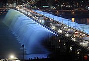
- N Seoul TowerN Seoul TowerN Seoul Tower is a communication and observation tower located on Namsan Mountain, central Seoul, South Korea. Built in 1969, at a cost of approximately $2.5 million, and opened to the public in 1980, the tower has been a symbol of Seoul and measures in height and tops out at above sea level. It...
, SeoulSeoulSeoul , officially the Seoul Special City, is the capital and largest metropolis of South Korea. A megacity with a population of over 10 million, it is the largest city proper in the OECD developed world...
Thailand
- Grand Palace with Wat Phra KaewWat Phra KaewThe Wat Phra Kaew is regarded as the most sacred Buddhist temple in Thailand. It is a "potent religio-political symbol and the palladium of Thai society". It is located in the historic centre of Bangkok , within the precincts of the Grand Palace.The main building is the central ubosoth, which...
, BangkokBangkokBangkok is the capital and largest urban area city in Thailand. It is known in Thai as Krung Thep Maha Nakhon or simply Krung Thep , meaning "city of angels." The full name of Bangkok is Krung Thep Mahanakhon Amon Rattanakosin Mahintharayutthaya Mahadilok Phop Noppharat Ratchathani Burirom... - Wat PhoWat PhoWat Pho , is a Buddhist temple in Phra Nakhon district, Bangkok, Thailand. It is located in the Rattanakosin district directly adjacent to the Grand Palace. Known also as the Temple of the Reclining Buddha, its official name is Wat Phra Chettuphon Wimon Mangkhalaram Ratchaworamahawihan...
, BangkokBangkokBangkok is the capital and largest urban area city in Thailand. It is known in Thai as Krung Thep Maha Nakhon or simply Krung Thep , meaning "city of angels." The full name of Bangkok is Krung Thep Mahanakhon Amon Rattanakosin Mahintharayutthaya Mahadilok Phop Noppharat Ratchathani Burirom... - Wat ArunWat ArunWat Arun Rajwararam is a Buddhist temple in the Bangkok Yai district of Bangkok, Thailand, on the Thonburi west bank of the Chao Phraya River. The full name of the temple is Wat Arunratchawararam Ratchaworamahawihan...
, BangkokBangkokBangkok is the capital and largest urban area city in Thailand. It is known in Thai as Krung Thep Maha Nakhon or simply Krung Thep , meaning "city of angels." The full name of Bangkok is Krung Thep Mahanakhon Amon Rattanakosin Mahintharayutthaya Mahadilok Phop Noppharat Ratchathani Burirom... - Baiyoke Tower IIBaiyoke Tower IIBaiyoke Tower II, located on 222 Ratchaprarop Road in the Ratchathewi district of Bangkok is Thailand's tallest building. It contains the Baiyoke Sky Hotel, the tallest hotel in Southeast Asia, and the fourth-tallest all-hotel structure in the world....
, BangkokBangkokBangkok is the capital and largest urban area city in Thailand. It is known in Thai as Krung Thep Maha Nakhon or simply Krung Thep , meaning "city of angels." The full name of Bangkok is Krung Thep Mahanakhon Amon Rattanakosin Mahintharayutthaya Mahadilok Phop Noppharat Ratchathani Burirom... - Ayutthaya Historical ParkAyutthaya historical parkThe Ayutthaya historical park covers the ruins of the old city of Ayutthaya, Thailand, which was founded by King Ramathibodi I in 1350 and was the capital of the country until its destruction by the Burmese army in 1767....
, AyutthayaAyutthaya (city)Ayutthaya city is the capital of Ayutthaya province in Thailand. Located in the valley of the Chao Phraya River. The city was founded in 1350 by King U Thong, who went there to escape a smallpox outbreak in Lop Buri and proclaimed it the capital of his kingdom, often referred to as the Ayutthaya...
United Arab Emirates
- Sheikh Zayed MosqueSheikh Zayed Mosque-External links:* * * *...
, Abu DhabiAbu DhabiAbu Dhabi , literally Father of Gazelle, is the capital and the second largest city of the United Arab Emirates in terms of population and the largest of the seven member emirates of the United Arab Emirates. Abu Dhabi lies on a T-shaped island jutting into the Persian Gulf from the central western... - Burj Al Arab, DubaiDubaiDubai is a city and emirate in the United Arab Emirates . The emirate is located south of the Persian Gulf on the Arabian Peninsula and has the largest population with the second-largest land territory by area of all the emirates, after Abu Dhabi...
- Burj Khalifa, DubaiDubaiDubai is a city and emirate in the United Arab Emirates . The emirate is located south of the Persian Gulf on the Arabian Peninsula and has the largest population with the second-largest land territory by area of all the emirates, after Abu Dhabi...
- Jumeirah Beach HotelJumeirah Beach HotelJumeirah Beach Hotel is a hotel in Dubai, United Arab Emirates. The hotel, which opened in 1997, is operated by the Dubai-based hotelier Jumeirah. The hotel contains 598 rooms and suites and 19 villas. This wave-shaped hotel complements the sail-shaped Burj Al Arab, which is adjacent to the...
, DubaiDubaiDubai is a city and emirate in the United Arab Emirates . The emirate is located south of the Persian Gulf on the Arabian Peninsula and has the largest population with the second-largest land territory by area of all the emirates, after Abu Dhabi... - Emirates TowersEmirates TowersThe Emirates Towers complex contains the Emirates Office Tower and Jumeirah Emirates Towers Hotel. The two towers, which rise to and , respectively, stand as the 12th- and 29th-tallest buildings in the world. The two towers are connected by a 9,000 m² two-storey retail complex known as "The...
, DubaiDubaiDubai is a city and emirate in the United Arab Emirates . The emirate is located south of the Persian Gulf on the Arabian Peninsula and has the largest population with the second-largest land territory by area of all the emirates, after Abu Dhabi... - Rose Tower, DubaiDubaiDubai is a city and emirate in the United Arab Emirates . The emirate is located south of the Persian Gulf on the Arabian Peninsula and has the largest population with the second-largest land territory by area of all the emirates, after Abu Dhabi...
- Almas TowerAlmas TowerAlmas Tower is a supertall skyscraper in Dubai, United Arab Emirates. Construction of the office building began in early 2005 and was completed in 2009 with the installation of some remaining cladding panels at the top of the tower. The building topped out at in 2008, becoming the third-tallest...
, DubaiDubaiDubai is a city and emirate in the United Arab Emirates . The emirate is located south of the Persian Gulf on the Arabian Peninsula and has the largest population with the second-largest land territory by area of all the emirates, after Abu Dhabi... - Palm IslandsPalm IslandsThe Palm Islands are an artificial archipelago in Dubai, United Arab Emirates on which major commercial and residential infrastructures will be constructed...
with Palm JumeirahPalm JumeirahThe Palm Jumeirah is an artificial archipelago created using land reclamation by Nakheel, a company owned by the Dubai government in United Arab Emirates. It is one of three islands called the Palm Islands which extend into the Persian Gulf, increasing Dubai’s shoreline by a total of...
, DubaiDubaiDubai is a city and emirate in the United Arab Emirates . The emirate is located south of the Persian Gulf on the Arabian Peninsula and has the largest population with the second-largest land territory by area of all the emirates, after Abu Dhabi... - The World ArchipelagoThe World (archipelago)The World or World Islands is an artificial archipelago of various small islands constructed in the rough shape of a world map, located off the coast of Dubai, United Arab Emirates. The World islands are composed mainly of sand dredged from Dubai's shallow coastal waters, and are one of several...
, DubaiDubaiDubai is a city and emirate in the United Arab Emirates . The emirate is located south of the Persian Gulf on the Arabian Peninsula and has the largest population with the second-largest land territory by area of all the emirates, after Abu Dhabi...
Yemen
- Tower Houses of ShibamShibamShibam is a town in Yemen with about 7,000 inhabitants. The first known inscription about the city dates from the 3rd century AD...
, ShibamShibamShibam is a town in Yemen with about 7,000 inhabitants. The first known inscription about the city dates from the 3rd century AD...
, HadhramautHadhramaut GovernorateHadhramaut or Hadramawt is a governorate of Yemen. Lying within the large historical region of Hadhramaut, it is the country's largest governorate.-Overview:...
, YemenYemenThe Republic of Yemen , commonly known as Yemen , is a country located in the Middle East, occupying the southwestern to southern end of the Arabian Peninsula. It is bordered by Saudi Arabia to the north, the Red Sea to the west, and Oman to the east....
Austria
- StephansdomStephansdomSt. Stephen's Cathedral is the mother church of the Archdiocese of Vienna and the seat of the Archbishop of Vienna, Christoph Cardinal Schönborn, OP...
, ViennaViennaVienna is the capital and largest city of the Republic of Austria and one of the nine states of Austria. Vienna is Austria's primary city, with a population of about 1.723 million , and is by far the largest city in Austria, as well as its cultural, economic, and political centre... - PestsäulePestsäule (Vienna)The Pestsäule is located on Graben, a street in the inner city of Vienna and is one of the most well-known and prominent pieces of sculpture in the city....
, ViennaViennaVienna is the capital and largest city of the Republic of Austria and one of the nine states of Austria. Vienna is Austria's primary city, with a population of about 1.723 million , and is by far the largest city in Austria, as well as its cultural, economic, and political centre... - Hofburg Imperial PalaceHofburg Imperial PalaceHofburg Palace is a palace located in Vienna, Austria, that has housed some of the most powerful people in Austrian history, including the Habsburg dynasty, rulers of the Austro-Hungarian empire. It currently serves as the official residence of the President of Austria...
with Schatzkammer of ViennaSchatzkammerSchatzkammer is a German word which translates as Treasure Room, and is a term also used in English for the collection of treasures, especially those in precious metals and jewels, of a ruler or other collector, kept in a secure room, often in the basement of a palace or castle...
, WinterreitschuleSpanish Riding SchoolThe Spanish Riding School of Vienna, Austria, is a traditional riding school for Lipizzan horses, which perform in the Winter Riding School in the Hofburg...
and /li> - Rathaus, ViennaViennaVienna is the capital and largest city of the Republic of Austria and one of the nine states of Austria. Vienna is Austria's primary city, with a population of about 1.723 million , and is by far the largest city in Austria, as well as its cultural, economic, and political centre...
- Kunsthistorisches MuseumKunsthistorisches MuseumThe Kunsthistorisches Museum is an art museum in Vienna, Austria. Housed in its festive palatial building on Ringstraße, it is crowned with an octagonal dome...
, ViennaViennaVienna is the capital and largest city of the Republic of Austria and one of the nine states of Austria. Vienna is Austria's primary city, with a population of about 1.723 million , and is by far the largest city in Austria, as well as its cultural, economic, and political centre... - Naturhistorisches MuseumNaturhistorisches MuseumThe Naturhistorisches Museum Wien or NHMW is a large museum located in Vienna, Austria.The collections displayed cover , and the museum has a website providing an overview as a video virtual tour....
, ViennaViennaVienna is the capital and largest city of the Republic of Austria and one of the nine states of Austria. Vienna is Austria's primary city, with a population of about 1.723 million , and is by far the largest city in Austria, as well as its cultural, economic, and political centre... - MuseumsquartierMuseumsquartierThe Museumsquartier is a 60,000 m² large area in the 7th district of the city of Vienna, Austria; it is the eighth largest cultural area in the world. The Museumsquartier contains Baroque buildings as well as Modern architecture by the architects Laurids and Manfred Ortner . The renovation of the...
with MUMOKMUMOKMUMOK is the abbreviation of "MUseum MOderner Kunst" Foundation Ludwig Vienna. It is located in the Museumsquartier in Vienna, Austria....
and Leopold MuseumLeopold MuseumThe Leopold Museum, housed in the Museumsquartier in Vienna, Austria, is home to one of the largest collections of modern Austrian art, featuring artists such as Egon Schiele, Gustav Klimt, Oskar Kokoschka and Richard Gerstl....
, ViennaViennaVienna is the capital and largest city of the Republic of Austria and one of the nine states of Austria. Vienna is Austria's primary city, with a population of about 1.723 million , and is by far the largest city in Austria, as well as its cultural, economic, and political centre... - BurgtheaterBurgtheaterThe Burgtheater , originally known as K.K. Theater an der Burg, then until 1918 as the K.K. Hofburgtheater, is the Austrian National Theatre in Vienna and one of the most important German language theatres in the world.The Burgtheater was created in 1741 and has become known as "die Burg" by the...
, ViennaViennaVienna is the capital and largest city of the Republic of Austria and one of the nine states of Austria. Vienna is Austria's primary city, with a population of about 1.723 million , and is by far the largest city in Austria, as well as its cultural, economic, and political centre... - Vienna State OperaVienna State OperaThe Vienna State Opera is an opera house – and opera company – with a history dating back to the mid-19th century. It is located in the centre of Vienna, Austria. It was originally called the Vienna Court Opera . In 1920, with the replacement of the Habsburg Monarchy by the First Austrian...
, ViennaViennaVienna is the capital and largest city of the Republic of Austria and one of the nine states of Austria. Vienna is Austria's primary city, with a population of about 1.723 million , and is by far the largest city in Austria, as well as its cultural, economic, and political centre... - Secession HallSecession hall (Austria)The Secession building is an exhibition hall built in 1897 by Joseph Maria Olbrich as an architectural manifesto for the Vienna Secession, located in Vienna, Austria...
, ViennaViennaVienna is the capital and largest city of the Republic of Austria and one of the nine states of Austria. Vienna is Austria's primary city, with a population of about 1.723 million , and is by far the largest city in Austria, as well as its cultural, economic, and political centre... - KarlsplatzKarlsplatzKarlsplatz is a town square on the border of the first and fourth districts of Vienna. It is one of the most frequented and best connected transportation hubs in Vienna. The Karlskirche is located here....
with KarlskircheKarlskircheThe St. Charles's Church is a church situated on the south side of Karlsplatz, Vienna. It is located on the edge of the 1st district, 200 metres outside the Ringstraße...
and Karlsplatz Stadtbahn StationKarlsplatz Stadtbahn StationKarlsplatz Stadtbahn Station is a former station of the Viennese Stadtbahn. The buildings above ground on Karlsplatz are a well-known example of Jugendstil architecture. These buildings were included in The Vienna Secession, as they followed many of the artistic styles of that movement...
, ViennaViennaVienna is the capital and largest city of the Republic of Austria and one of the nine states of Austria. Vienna is Austria's primary city, with a population of about 1.723 million , and is by far the largest city in Austria, as well as its cultural, economic, and political centre... - Musikverein, ViennaViennaVienna is the capital and largest city of the Republic of Austria and one of the nine states of Austria. Vienna is Austria's primary city, with a population of about 1.723 million , and is by far the largest city in Austria, as well as its cultural, economic, and political centre...
- Belvedere PalaceBelvedere (palace)The Belvedere is a historical building complex in Vienna, Austria, consisting of two Baroque palaces the Upper and Lower Belvedere, the Orangery, and the Palace Stables. The buildings are set in a Baroque park landscape in the 3rd district of the city, south-east of its centre. It houses the...
with Austrian GalleryÖsterreichische Galerie BelvedereThe Österreichische Galerie Belvedere is a museum housed in the Belvedere palace, in Vienna, Austria.The art collection includes masterpieces from the Middle Ages and Baroque until the 21st century, though it focuses on Austrian painters from the Fin de Siècle and Art Nouveau period...
, ViennaViennaVienna is the capital and largest city of the Republic of Austria and one of the nine states of Austria. Vienna is Austria's primary city, with a population of about 1.723 million , and is by far the largest city in Austria, as well as its cultural, economic, and political centre... - RingstraßeRingstraßeThe Ringstraße is a circular road surrounding the Innere Stadt district of Vienna, Austria and is one of its main sights...
with VotivkircheVotivkircheThe Votive Church in Vienna, Austria, is one of the most important neo-Gothic religious architectural sites in the world.- Origin :Located on Ringstraße in the Alsergrund district near the University of Vienna, the origin of the church derives from a knife-attack on Emperor Franz Joseph by...
and Parliament BuildingAustrian Parliament BuildingThe Austrian Parliament Building in Vienna is where the two Houses of the Parliament of Austria conduct their sittings. The building is on the Ringstraße boulevard in the first district Innere Stadt, close by the Hofburg Palace and the Palace of Justice.The main construction lasted from 1874 to 1883...
, ViennaViennaVienna is the capital and largest city of the Republic of Austria and one of the nine states of Austria. Vienna is Austria's primary city, with a population of about 1.723 million , and is by far the largest city in Austria, as well as its cultural, economic, and political centre... - Kirche am SteinhofKirche am SteinhofThe Kirche am Steinhof in Vienna is the Roman Catholic oratory of the Steinhof Psychiatric Hospital...
, ViennaViennaVienna is the capital and largest city of the Republic of Austria and one of the nine states of Austria. Vienna is Austria's primary city, with a population of about 1.723 million , and is by far the largest city in Austria, as well as its cultural, economic, and political centre... - Karl Marx-Hof, ViennaViennaVienna is the capital and largest city of the Republic of Austria and one of the nine states of Austria. Vienna is Austria's primary city, with a population of about 1.723 million , and is by far the largest city in Austria, as well as its cultural, economic, and political centre...
- PraterPraterThe Wiener Prater is a large public park in Vienna's 2nd district . The amusement park, often simply called "Prater", stands in one corner of the Wiener Prater and includes the .-Name:...
with Riesenrad, ViennaViennaVienna is the capital and largest city of the Republic of Austria and one of the nine states of Austria. Vienna is Austria's primary city, with a population of about 1.723 million , and is by far the largest city in Austria, as well as its cultural, economic, and political centre... - HundertwasserhausHundertwasserhausright|thumb|Hundertwasser House ViennaThe Hundertwasserhaus is an apartment house in Vienna, Austria, built after the idea and concept of Austrian artist Friedensreich Hundertwasser with architect Joseph Krawina as a co-author...
, ViennaViennaVienna is the capital and largest city of the Republic of Austria and one of the nine states of Austria. Vienna is Austria's primary city, with a population of about 1.723 million , and is by far the largest city in Austria, as well as its cultural, economic, and political centre... - Schönbrunn PalaceSchönbrunn PalaceSchönbrunn Palace is a former imperial 1,441-room Rococo summer residence in Vienna, Austria. One of the most important cultural monuments in the country, since the 1960s it has been one of the major tourist attractions in Vienna...
with GlorietteGlorietteA gloriette is a building in a garden erected on a site that is elevated with respect to the surroundings...
, ViennaViennaVienna is the capital and largest city of the Republic of Austria and one of the nine states of Austria. Vienna is Austria's primary city, with a population of about 1.723 million , and is by far the largest city in Austria, as well as its cultural, economic, and political centre... - Melk AbbeyMelk AbbeyMelk Abbey or Stift Melk is an Austrian Benedictine abbey, and one of the world's most famous monastic sites. It is located above the town of Melk on a rocky outcrop overlooking the river Danube in Lower Austria, adjoining the Wachau valley....
, MelkMelkMelk is a city of Austria, in the federal state of Lower Austria, next to the Wachau valley along the Danube. Melk has a population of 5,222 ....
Armenia
- Haghpat MonasteryHaghpat MonasteryHaghpat Monastery, also known as Haghpatavank , is a medieval Armenian monastery complex in Haghpat, Armenia....
and Sanahin MonasterySanahinSanahin is a village in the northern province of Lori in Armenia, now considered part of the city of Alaverdi...
, HaghpatHaghpatHaghpat is a village in the Northern Lori province of Armenia, close to the city of Alaverdi and the state border with Georgia.It is notable for Haghpat Monastery, a religious complex founded in the 10th century and included in the UNESCO World Heritage List along with monasteries in nearby Sanahin...
/SanahinSanahinSanahin is a village in the northern province of Lori in Armenia, now considered part of the city of Alaverdi...
, Lori - Etchmiadzin Cathedral, Saint Gayane Church and St. Hripsime ChurchSt. Hripsime Church, EchmiadzinSaint Hripsimé Church is one of the oldest surviving churches in Armenia. The church was erected by Catholicos Komitas atop the original mausoleum built by Catholicos Sahak the Great in the year 395 AD that contained the remains of the martyred Saint Hripsimé to whom the church was dedicated. The...
, Etchmiadzin, Armavir - Monastery of GeghardGeghard, ArmeniaGeghard is a town in the Kotayk Province of Armenia. The town is best known for the monastery of Geghard, a UNESCO World Heritage Site....
, GeghardGeghard, ArmeniaGeghard is a town in the Kotayk Province of Armenia. The town is best known for the monastery of Geghard, a UNESCO World Heritage Site....
, Kotayk
Azerbaijan
- Palace of the ShirvanshahsPalace of the ShirvanshahsPalace of the Shirvanshahs is the biggest monument of the Shirvan-Absheron branch of the Azerbaijan architecture, situated in the Inner City of Baku...
, BakuBakuBaku , sometimes spelled as Baki or Bakou, is the capital and largest city of Azerbaijan, as well as the largest city on the Caspian Sea and of the Caucasus region. It is located on the southern shore of the Absheron Peninsula, which projects into the Caspian Sea. The city consists of two principal...
, AbsheronAbsheronThe Absheron peninsula, is a region in Azerbaijan. It is host to Baku, the biggest and the most populous city of the country, and also the Baku metropolitan area, with its satellite cities Sumgayit and Khyrdalan.... - Maiden TowerMaiden Tower (Baku)The Maiden Tower or also known locally as Giz Galasi located in the Old City, Baku in Azerbaijan is an ancient tower with cultural affinity corroborating the presence Zoroastrians, Sassanians, Arabs, Persians, Shirvanis, Ottomans, and Russians...
, BakuBakuBaku , sometimes spelled as Baki or Bakou, is the capital and largest city of Azerbaijan, as well as the largest city on the Caspian Sea and of the Caucasus region. It is located on the southern shore of the Absheron Peninsula, which projects into the Caspian Sea. The city consists of two principal...
, AbsheronAbsheronThe Absheron peninsula, is a region in Azerbaijan. It is host to Baku, the biggest and the most populous city of the country, and also the Baku metropolitan area, with its satellite cities Sumgayit and Khyrdalan....
Belarus
- Mir Castle ComplexMir Castle ComplexThe Mirsky Castle Complex , is a UNESCO World Heritage site in Belarus located in the town of Mir in the Karelichy District of the Hrodna voblast, at , 29 km to the north-west from another World Heritage site, Nesvizh Castle....
, MirMir, BelarusMir is an urban settlement in Kareličy raion, Hrodna Voblast, Belarus on the banks of Miranka River, about 85 kilometers southwest of the national capital, Minsk....
, HrodnaHrodna VoblastHrodna Voblast or Grodno Oblast is a voblast in northwestern Belarus.The capital - Grodno is the biggest city of the province. It lies on the Neman River. Grodno's existence is attested to from 1127. Two castles dating from the 14th - 18th centuries are located here on the steep right bank of... - Nesvizh Castle, NesvizhNesvizhNesvizh is a city in Belarus. It is the administrative center of the Nesvizh District of Minsk Province and location of the Nesvizh Castle World Heritage Site. Its 2009 population is 14,300 .-History:...
Belgium
- Grand PlaceGrand PlaceThe Grand Place or Grote Markt is the central square of Brussels. It is surrounded by guildhalls, the city's Town Hall, and the Breadhouse . The square is the most important tourist destination and most memorable landmark in Brussels, along with the Atomium and Manneken Pis...
with Town HallBrussels Town HallThe Town Hall of the City of Brussels is a Gothic building from the Middle Ages. It is located on the famous Grand Place in Brussels, Belgium....
, BrusselsBrusselsBrussels , officially the Brussels Region or Brussels-Capital Region , is the capital of Belgium and the de facto capital of the European Union... - AtomiumAtomiumThe Atomium is a monument in Brussels, originally built for Expo '58, the 1958 Brussels World's Fair. Designed by André Waterkeyn, it stands 102 metres tall...
, BrusselsBrusselsBrussels , officially the Brussels Region or Brussels-Capital Region , is the capital of Belgium and the de facto capital of the European Union... - Manneke Pis, BrusselsBrusselsBrussels , officially the Brussels Region or Brussels-Capital Region , is the capital of Belgium and the de facto capital of the European Union...
- Belgian Centre for Comic Strip ArtBelgian Centre for Comic Strip ArtThe Belgian Comic Strip Center chronicles the history of Belgian comics...
, BrusselsBrusselsBrussels , officially the Brussels Region or Brussels-Capital Region , is the capital of Belgium and the de facto capital of the European Union... - Royal Palace, BrusselsBrusselsBrussels , officially the Brussels Region or Brussels-Capital Region , is the capital of Belgium and the de facto capital of the European Union...
- Royal Museums of Fine ArtsRoyal Museums of Fine Arts of BelgiumThe Royal Museums of Fine Arts of Belgium , is one of the most famous museums in Belgium.-The museum:...
, BrusselsBrusselsBrussels , officially the Brussels Region or Brussels-Capital Region , is the capital of Belgium and the de facto capital of the European Union... - St. Michael and St. Gudula Cathedral, BrusselsBrusselsBrussels , officially the Brussels Region or Brussels-Capital Region , is the capital of Belgium and the de facto capital of the European Union...
- Berlaymont buildingBerlaymont buildingThe Berlaymont is an office building in Brussels, Belgium that houses the headquarters of the European Commission, which is the executive of the European Union...
and Espace LéopoldEspace LéopoldThe Espace Léopold or is the complex of parliament buildings in Brussels housing the European Parliament, a legislative chamber of the European Union ....
, BrusselsBrusselsBrussels , officially the Brussels Region or Brussels-Capital Region , is the capital of Belgium and the de facto capital of the European Union... - Jubelpark/Parc du CinquantenaireCinquantenaireParc du Cinquantenaire or Jubelpark is a large public, urban park in the easternmost part of the European Quarter in Brussels, Belgium....
, BrusselsBrusselsBrussels , officially the Brussels Region or Brussels-Capital Region , is the capital of Belgium and the de facto capital of the European Union... - Horta MuseumHorta MuseumThe Horta Museum is a museum dedicated to the life and work of the Belgian Art Nouveau architect Victor Horta and his time. The museum is housed in Horta's former house and atelier, Maison & Atelier Horta , in the Brussels municipality of Saint-Gilles...
, BrusselsBrusselsBrussels , officially the Brussels Region or Brussels-Capital Region , is the capital of Belgium and the de facto capital of the European Union... - Basilica of the Sacred Heart, BrusselsBrusselsBrussels , officially the Brussels Region or Brussels-Capital Region , is the capital of Belgium and the de facto capital of the European Union...
- Stoclet Palace, BrusselsBrusselsBrussels , officially the Brussels Region or Brussels-Capital Region , is the capital of Belgium and the de facto capital of the European Union...
- Onze-Lieve-Vrouwekathedraal, Antwerp
- Antwerp City HallAntwerp City HallThe City Hall of Antwerp, Belgium, stands on the western side of Antwerp's Grote Markt . Erected between 1561 and 1565 to the design of Cornelis Floris de Vriendt and several other architects and artists, this Renaissance building incorporates both Flemish and Italian influences.The low arcaded...
, Antwerp - RubenshuisRubenshuisThe Rubenshuis is the former home and studio of Peter Paul Rubens in Antwerp. It is now a museum.- Rubens's house during his lifetime :...
, Antwerp - Royal Museum of Fine Arts, Antwerp
- Grote MarktGrote Markt (Bruges)The Markt of Bruges is located in the heart of the city and covers an area of about 1 hectare. Some historical highlights around the square include the 12th-century belfry and the Provincial Court The Markt ("Market Square") of Bruges is located in the heart of the city and covers an area of...
, Brugges, West Flanders - BelfryBelfry of BrugesThe belfry of Bruges, or Belfort, is a medieval bell tower in the historical centre of Bruges, Belgium. One of the city's most prominent symbols, the belfry formerly housed a treasury and the municipal archives, and served as an observation post for spotting fires and other danger...
, Brugges, West Flanders - GroeningemuseumGroeningemuseumThe Groeningemuseum is a municipal museum of Bruges, Belgium.It houses a comprehensive survey of six centuries of Flemish and Belgian painting, from Jan van Eyck to Marcel Broodthaers...
, Brugges, West Flanders - Cloth HallCloth Hall, YpresThe Cloth Hall , of Ypres, Belgium, was one of the largest commercial buildings of the Middle Ages, when it served as the main market and warehouse for the Flemish city's prosperous cloth industry. The original structure, erected mainly in the 13th century and completed 1304, lay in ruins after...
, YpresYpresYpres is a Belgian municipality located in the Flemish province of West Flanders. The municipality comprises the city of Ypres and the villages of Boezinge, Brielen, Dikkebus, Elverdinge, Hollebeke, Sint-Jan, Vlamertinge, Voormezele, Zillebeke, and Zuidschote...
, West Flanders - Sint BaafskathedraalSaint Bavo Cathedralthumb|right|225px|Sint-Baafs CathedralThe Saint Bavo Cathedral is the seat of the diocese of Ghent. It is named for Saint Bavo of Ghent....
, GhentGhentGhent is a city and a municipality located in the Flemish region of Belgium. It is the capital and biggest city of the East Flanders province. The city started as a settlement at the confluence of the Rivers Scheldt and Lys and in the Middle Ages became one of the largest and richest cities of...
, East FlandersEast FlandersEast Flanders is a province of Flanders, one of the three regions of Belgium. It borders on the Netherlands and in Belgium on the provinces of Antwerp, Flemish Brabant , of Hainaut and of West Flanders... - GravensteenGravensteenThe Gravensteen is a castle in Ghent originating from the Middle Ages. The name means "castle of the count" in Dutch. -History:The present castle was built in 1180 by count Philip of Alsace and was modeled after the crusaders castles that Philip of Alsace encountered while he participated in the...
, GhentGhentGhent is a city and a municipality located in the Flemish region of Belgium. It is the capital and biggest city of the East Flanders province. The city started as a settlement at the confluence of the Rivers Scheldt and Lys and in the Middle Ages became one of the largest and richest cities of...
, East FlandersEast FlandersEast Flanders is a province of Flanders, one of the three regions of Belgium. It borders on the Netherlands and in Belgium on the provinces of Antwerp, Flemish Brabant , of Hainaut and of West Flanders... - GrasleiGhentGhent is a city and a municipality located in the Flemish region of Belgium. It is the capital and biggest city of the East Flanders province. The city started as a settlement at the confluence of the Rivers Scheldt and Lys and in the Middle Ages became one of the largest and richest cities of...
, GhentGhentGhent is a city and a municipality located in the Flemish region of Belgium. It is the capital and biggest city of the East Flanders province. The city started as a settlement at the confluence of the Rivers Scheldt and Lys and in the Middle Ages became one of the largest and richest cities of...
, East FlandersEast FlandersEast Flanders is a province of Flanders, one of the three regions of Belgium. It borders on the Netherlands and in Belgium on the provinces of Antwerp, Flemish Brabant , of Hainaut and of West Flanders... - Grote MarktGrote Markt (Leuven)The Grote Markt of Leuven, Belgium is situated between the Oude Markt and the Fochplein and near both the Bondgenotenlaan and the Muntstraat .Its location on the crossing of some of Leuven's most famous and most touristic spots...
with Town HallLeuven Town HallThe Town Hall of Leuven, Belgium, is a landmark building on that city's Grote Markt square, across from the monumental St. Peter's Church...
, LeuvenLeuvenLeuven is the capital of the province of Flemish Brabant in the Flemish Region, Belgium...
, Flemish BrabantFlemish BrabantFlemish Brabant is a province of Flanders, one of the three regions of Belgium. It borders on the Belgian provinces of Antwerp, Limburg, Liège, Walloon Brabant, Hainaut and East Flanders. Flemish Brabant also completely surrounds the Brussels-Capital Region. Its capital is Leuven... - Alden Biesen CastleAlden Biesen CastleAlden Biesen is a 16th century castle in Belgium, located in the small village of Rijkhoven in the municipality of Bilzen in the province of Limburg.-Present day:...
, RijkhovenRijkhovenRijkhoven is a small village in the municipality of Bilzen, Belgium. There is a castle built near it called Alden Biesen. Once it was a part of the County of Loon....
, LimburgLimburg (Belgium)Limburg is the easternmost province of modern Flanders, which is one of the three main political and cultural sub-divisions of modern Belgium. It is located west of the river Meuse . It borders on the Dutch provinces of North Brabant and Limburg and the Belgian provinces of Liège, Flemish Brabant... - Flemish BéguinagesBéguinageA béguinage or begijnhof is a collection of small buildings used by Beguines. These were various lay sisterhoods of the Roman Catholic Church, founded in the 13th century in the Low Countries, comprising religious women who sought to serve God without retiring from the world.-Description:A...
- Tournai CathedralTournai CathedralThe Cathedral of Our Lady is Roman Catholic church, see of the Diocese of Tournai in Tournai, Belgium. It has been classified both as a Wallonia's major heritage since 1936 and as a World Heritage Site since 2000.-History:...
, TournaiTournaiTournai is a Walloon city and municipality of Belgium located 85 kilometres southwest of Brussels, on the river Scheldt, in the province of Hainaut.... - Alden Biesen CastleAlden Biesen CastleAlden Biesen is a 16th century castle in Belgium, located in the small village of Rijkhoven in the municipality of Bilzen in the province of Limburg.-Present day:...
, BilzenBilzenBilzen is a Belgian city and municipality located in the Belgian province of Limburg near Hasselt. On January 1, 2006, Bilzen had a total population of 30,057... - Collegiate Church of Notre-DameDinantDinant is a Walloon city and municipality located on the River Meuse in the Belgian province of Namur, Belgium. The Dinant municipality includes the old communes of Anseremme, Bouvignes-sur-Meuse, Dréhance, Falmagne, Falmignoul, Foy-Notre-Dame, Furfooz, Lisogne, Sorinnes, and Thynes.-Origins to...
, DinantDinantDinant is a Walloon city and municipality located on the River Meuse in the Belgian province of Namur, Belgium. The Dinant municipality includes the old communes of Anseremme, Bouvignes-sur-Meuse, Dréhance, Falmagne, Falmignoul, Foy-Notre-Dame, Furfooz, Lisogne, Sorinnes, and Thynes.-Origins to... - Curtius MuseumCurtius MuseumThe Curtius Museum is a museum of archaeology and decorative arts, located on the bank of the Meuse River in Liège, classified as a Major Heritage of Wallonia...
, Liège
Bosnia and Herzegovina
- Stari MostStari mostStari Most is a 16th century Ottoman bridge in the city of Mostar, Bosnia and Herzegovina that crosses the river Neretva and connects two parts of the city. The Old Bridge stood for 427 years, until it was destroyed on November 9, 1993 during the Croat-Bosniak War...
, MostarMostarMostar is a city and municipality in Bosnia and Herzegovina, the largest and one of the most important cities in the Herzegovina region and the center of the Herzegovina-Neretva Canton of the Federation. Mostar is situated on the Neretva river and is the fifth-largest city in the country...
, Herzegovina-NeretvaHerzegovina-Neretva CantonThe Herzegovina-Neretva Canton is one of the 10 cantons of Bosnia and Herzegovina. The canton mainly comprises the Neretva river valley area and parts of Herzegovina west of Mostar, its administrative center.-Municipalities:...
, Federation of Bosnia and HerzegovinaFederation of Bosnia and HerzegovinaThe Federation of Bosnia and Herzegovina is one of the two political entities that compose the sovereign country of Bosnia and Herzegovina . The two entities are delineated by the Inter-Entity Boundary Line... - Mehmed Paša Sokolović BridgeMehmed Paša Sokolovic BridgeThe Mehmed Paša Sokolović Bridge is a historic bridge in Višegrad, over the Drina River in eastern Republika Srpska entity of Bosnia and Herzegovina. It was completed in 1577 AD by the Ottoman court architect Mimar Sinan on the order of the Grand Vizier Mehmed Paša Sokolović...
, VišegradVišegradVišegrad is a town and municipality in Bosnia and Herzegovina. It is part of the Republika Srpska entity. It is on the river Drina, located on the road from Goražde and Ustiprača towards Užice, Serbia.-History:...
, Foča, Republika SrpskaRepublika SrpskaRepublika Srpska is one of two main political entities of Bosnia and Herzegovina, the other being the Federation of Bosnia and Herzegovina...
Bulgaria
- Alexander Nevsky CathedralAlexander Nevsky Cathedral, SofiaThe St. Alexander Nevsky Cathedral is a Bulgarian Orthodox cathedral in Sofia, the capital of Bulgaria. Built in Neo-Byzantine style, it serves as the cathedral church of the Patriarch of Bulgaria and is one of the largest Eastern Orthodox cathedrals in the world, as well as one of Sofia's symbols...
, SofiaSofiaSofia is the capital and largest city of Bulgaria and the 12th largest city in the European Union with a population of 1.27 million people. It is located in western Bulgaria, at the foot of Mount Vitosha and approximately at the centre of the Balkan Peninsula.Prehistoric settlements were excavated... - Boyana ChurchBoyana ChurchThe Boyana Church is a medieval Bulgarian Orthodox church situated on the outskirts of Sofia, the capital of Bulgaria, in the Boyana quarter...
, SofiaSofiaSofia is the capital and largest city of Bulgaria and the 12th largest city in the European Union with a population of 1.27 million people. It is located in western Bulgaria, at the foot of Mount Vitosha and approximately at the centre of the Balkan Peninsula.Prehistoric settlements were excavated...
, SofiaSofiaSofia is the capital and largest city of Bulgaria and the 12th largest city in the European Union with a population of 1.27 million people. It is located in western Bulgaria, at the foot of Mount Vitosha and approximately at the centre of the Balkan Peninsula.Prehistoric settlements were excavated... - Rila MonasteryRila MonasteryThe Monastery of Saint Ivan of Rila, better known as the Rila Monastery is the largest and most famous Eastern Orthodox monastery in Bulgaria. It is situated in the southwestern Rila Mountains, south of the capital Sofia in the deep valley of the Rilska River at an elevation of above sea level...
, Rila MountainsRilaRila is a mountain range in southwestern Bulgaria and the highest mountain range of Bulgaria and the Balkans, with its highest peak being Musala at 2,925 m...
, KyustendilKyustendil Province-Religion:Religious adherence in the province according to 2001 census:-Language:Mother tongues in the province according to 2001 census:* 153,242 Bulgarian * 7,929 Roma * 1363 others and unspecified -Ethnic groups:... - Thracian Tomb of KazanlakThracian Tomb of KazanlakThe Thracian Tomb of Kazanlak is a vaulted brickwork "beehive" tomb near the town of Kazanlak in central Bulgaria.The tomb is part of a large Thracian necropolis. It comprises a narrow corridor and a round burial chamber, both decorated with murals representing a Thracian couple at a ritual...
, KazanlakKazanlakKazanlak, formerly Kazanlık is a Bulgarian town in Stara Zagora Province, located in the middle of the plain of the same name, at the foot of the Balkan mountain range, at the eastern end of the Rose Valley...
, Stara ZagoraStara Zagora ProvinceStara Zagora is a province of south central Bulgaria. It is named after its administrative and industrial centre—the city of Stara Zagora—the sixth-biggest town in the country... - Rock-Hewn Churches of IvanovoRock-hewn Churches of IvanovoThe Rock-hewn Churches of Ivanovo are a group of monolithic churches, chapels and monasteries hewn out of solid rock and completely different from other monastery complexes in Bulgaria, located near the village of Ivanovo, 20 km south of Rousse, on the high rocky banks of the Rusenski Lom, 32 m...
, IvanovoIvanovo, Rousse ProvinceIvanovo is a village in northeastern Bulgaria, part of Rousse Province. It is the administrative centre of Ivanovo Municipality, which lies in the central part of Rousse Province....
, Rousse - Thracian Tomb of SveshtariThracian Tomb of SveshtariThe Thracian Tomb of Sveshtari is situated 2.5 km southwest of the village of Sveshtari, Razgrad Province, which is located 42 km northeast of Razgrad, in the northeast of Bulgaria....
, Sveshtari, RazgradRazgrad ProvinceRazgrad Province , former name Razgrad okrug) is a province in Northeastern Bulgaria, geographically part of the Ludogorie region. It is named after its administrative and industrial centre - the town of Razgrad... - Madara RiderMadara RiderThe Madara Rider or Madara Horseman is an early medieval large rock relief carved on the Madara Plateau east of Shumen in northeastern Bulgaria, near the village of Madara....
, MadaraMadara (village)Madara is a village in northeastern Bulgaria, part of Shumen municipality, Shumen Province. Madara lies east of the city of Shumen, at the western foot of the Madara plateau....
, ShumenShumen Province-Religion:Religious adherence in the province according to 2001 census:-Transportation:Shumen lies on the main route between Varna and Sofia and is served by numerous trains and buses serving the city. The city is also very well connected with Istanbul which serves the large Turkish community in...
Croatia
- Euphrasian BasilicaEuphrasian BasilicaThe Euphrasian Basilica is a basilica in Poreč, Croatia. The episcopal complex, including, apart the basilica itself, a sacristy, a baptistery and the bell tower of the nearby archbishop's palace, is one of the best examples of early Byzantine architecture in the Mediterranean region.The...
, PorečPorecPoreč is a town and municipality on the western coast of the Istrian peninsula, in Istria County, Croatia. Its major landmark is the 6th century Euphrasian Basilica, a UNESCO World Heritage Site since 1997....
, IstriaIstriaIstria , formerly Histria , is the largest peninsula in the Adriatic Sea. The peninsula is located at the head of the Adriatic between the Gulf of Trieste and the Bay of Kvarner... - Cathedral of St. JamesCathedral of St. James, ŠibenikThe Cathedral of St. James inŠibenik, Croatia is a triple-nave basilica with three apses and a dome in the city of Šibenik, Croatia. It is the church of the Catholic Church in Croatia, and the see of the Šibenik diocese. It is also the most important architectural monument of the Renaissance in...
, ŠibenikŠibenikŠibenik is a historic town in Croatia, with population of 51,553 . It is located in central Dalmatia where the river Krka flows into the Adriatic Sea...
, DalmatiaDalmatiaDalmatia is a historical region on the eastern coast of the Adriatic Sea. It stretches from the island of Rab in the northwest to the Bay of Kotor in the southeast. The hinterland, the Dalmatian Zagora, ranges from fifty kilometers in width in the north to just a few kilometers in the south....
, - Diocletian's PalaceDiocletian's PalaceDiocletian's Palace is a building in Split, Croatia, that was built by the Roman emperor Diocletian at the turn of the fourth century AD.Diocletian built the massive palace in preparation for his retirement on 1 May 305 AD. It lies in a bay on the south side of a short peninsula running out from...
, SplitSplit (city)Split is a Mediterranean city on the eastern shores of the Adriatic Sea, centered around the ancient Roman Palace of the Emperor Diocletian and its wide port bay. With a population of 178,192 citizens, and a metropolitan area numbering up to 467,899, Split is by far the largest Dalmatian city and...
, DalmatiaDalmatiaDalmatia is a historical region on the eastern coast of the Adriatic Sea. It stretches from the island of Rab in the northwest to the Bay of Kotor in the southeast. The hinterland, the Dalmatian Zagora, ranges from fifty kilometers in width in the north to just a few kilometers in the south....
Cyprus
- Archeological Site of KourionKourionKourion , also Curias or Latin: Curium, was a city in Cyprus, which endured from antiquity until the early Middle Ages. Kourion is situated on the south shores of the island to the west of the river Lycus , 16 M. P. from Amathus. , and was recorded by numerous ancient authors including Ptolemy...
with Kourion TheatreKourionKourion , also Curias or Latin: Curium, was a city in Cyprus, which endured from antiquity until the early Middle Ages. Kourion is situated on the south shores of the island to the west of the river Lycus , 16 M. P. from Amathus. , and was recorded by numerous ancient authors including Ptolemy...
, LimassolLimassolLimassol is the second-largest city in Cyprus, with a population of 228,000 . It is the largest city in geographical size, and the biggest municipality on the island. The city is located on Akrotiri Bay, on the island's southern coast and it is the capital of Limassol District.Limassol is the...
, LimassolLimassol DistrictLimassol District is one of the six districts of Cyprus. Its main town is Limassol. Part of the British overseas territory of Akrotiri and Dhekelia forms an enclave on the Akrotiri peninsula, under the sovereignty of the United Kingdom....
Czech Republic
- Charles BridgeCharles BridgeThe Charles Bridge is a famous historic bridge that crosses the Vltava river in Prague, Czech Republic. Its construction started in 1357 under the auspices of King Charles IV, and finished in the beginning of the 15th century...
, PraguePraguePrague is the capital and largest city of the Czech Republic. Situated in the north-west of the country on the Vltava river, the city is home to about 1.3 million people, while its metropolitan area is estimated to have a population of over 2.3 million... - St. Nicolas ChurchMalá StranaMalá Strana is a district of the city of Prague, Czech Republic, and one of its most historic regions.The name translated into English literally means "Little Side", though it is frequently referred to as "Lesser Town", "Lesser Quarter", or "Lesser Side"...
, PraguePraguePrague is the capital and largest city of the Czech Republic. Situated in the north-west of the country on the Vltava river, the city is home to about 1.3 million people, while its metropolitan area is estimated to have a population of over 2.3 million... - Wallenstein PalaceWallenstein PalaceWallenstein Palace is a Baroque palace in Malá Strana, Prague, currently the home of the Czech Senate.-History:The original Palace was built in years 1623-1630 by Albrecht von Wallenstein, Duke of Mecklenburg , who made his name and fortune as the Commander-in-Chief of the Imperial forces in the...
, PraguePraguePrague is the capital and largest city of the Czech Republic. Situated in the north-west of the country on the Vltava river, the city is home to about 1.3 million people, while its metropolitan area is estimated to have a population of over 2.3 million... - Prague CastlePrague CastlePrague Castle is a castle in Prague where the Kings of Bohemia, Holy Roman Emperors and presidents of Czechoslovakia and the Czech Republic have had their offices. The Czech Crown Jewels are kept here...
with St. Vitus CathedralSt. Vitus CathedralSaint Vitus' Cathedral is as a Roman Catholic cathedral in Prague, and the seat of the Archbishop of Prague. The full name of the cathedral is St. Vitus, St. Wenceslas and St. Adalbert Cathedral...
, St. George's Basilica and St. George's ConventPrague CastlePrague Castle is a castle in Prague where the Kings of Bohemia, Holy Roman Emperors and presidents of Czechoslovakia and the Czech Republic have had their offices. The Czech Crown Jewels are kept here...
, PraguePraguePrague is the capital and largest city of the Czech Republic. Situated in the north-west of the country on the Vltava river, the city is home to about 1.3 million people, while its metropolitan area is estimated to have a population of over 2.3 million... - LoretaLoretaLoreta is a large pilgrimage destination in Hradčany, a district of Prague, Czech Republic. It consists of a cloister, the church of the Lord’s Birth, a Holy Hut and the clock tower with a famous chime....
, PraguePraguePrague is the capital and largest city of the Czech Republic. Situated in the north-west of the country on the Vltava river, the city is home to about 1.3 million people, while its metropolitan area is estimated to have a population of over 2.3 million... - Strahov MonasteryStrahov MonasteryStrahov Monastery is a Premonstratensian abbey founded in 1149 by Bishop Jindřich Zdík, Bishop John of Prague, and Prince Vladislav II. It is located in Strahov, Prague, Czech Republic.-The founding of a monastery:...
, PraguePraguePrague is the capital and largest city of the Czech Republic. Situated in the north-west of the country on the Vltava river, the city is home to about 1.3 million people, while its metropolitan area is estimated to have a population of over 2.3 million... - Bedřich Smetana MuseumBedrich Smetana MuseumThe Smetana Museum in Prague is a museum which is dedicated to the life and works of famous Czech composer Bedřich Smetana...
, PraguePraguePrague is the capital and largest city of the Czech Republic. Situated in the north-west of the country on the Vltava river, the city is home to about 1.3 million people, while its metropolitan area is estimated to have a population of over 2.3 million... - ClementinumClementinumThe Clementinum is a historic complex of buildings in Prague. Until recently the complex hosted the National, University and Technical libraries, the City Library also being located nearby on Mariánské Náměstí. The Technical library and the Municipal library have moved to the Prague National...
, PraguePraguePrague is the capital and largest city of the Czech Republic. Situated in the north-west of the country on the Vltava river, the city is home to about 1.3 million people, while its metropolitan area is estimated to have a population of over 2.3 million... - Old Town Square with Týn ChurchChurch of Our Lady in front of TýnThe Church of Our Lady before Týn is a dominant feature of the Old Town of Prague, Czech Republic, and has been the main church of this part of the city since the 14th century...
, St. Nicholas ChurchOld Town Square (Prague)Old Town Square is a historic square in the Old Town quarter of Prague in the Czech Republic at .Located between Wenceslas Square and the Charles Bridge, Prague's Old Town Square is often bursting at the seams with tourists in the summer. Featuring various architectural styles including the...
and Jan Hus MemorialJan Hus MemorialThe Jan Hus Memorial stands at one end of Old Town Square, Prague in the Czech Republic. The huge monument depicts victorious Hussite warriors and Protestants who were forced into exile 200 years after Hus and a young mother which symbolizes national rebirth. It was unveiled in 1915 to...
, PraguePraguePrague is the capital and largest city of the Czech Republic. Situated in the north-west of the country on the Vltava river, the city is home to about 1.3 million people, while its metropolitan area is estimated to have a population of over 2.3 million... - Old Town City Hall, Prague Astronomical Clock, PraguePraguePrague is the capital and largest city of the Czech Republic. Situated in the north-west of the country on the Vltava river, the city is home to about 1.3 million people, while its metropolitan area is estimated to have a population of over 2.3 million...
- Old Jewish Cemetery, PraguePraguePrague is the capital and largest city of the Czech Republic. Situated in the north-west of the country on the Vltava river, the city is home to about 1.3 million people, while its metropolitan area is estimated to have a population of over 2.3 million...
- Old New SynagogueOld New SynagogueThe Old New Synagogue situated in Josefov, Prague, is Europe's oldest active synagogue. It is also the oldest surviving medieval synagogue of twin nave design.Completed in 1270 in gothic style, it was one of Prague's first gothic buildings...
, PraguePraguePrague is the capital and largest city of the Czech Republic. Situated in the north-west of the country on the Vltava river, the city is home to about 1.3 million people, while its metropolitan area is estimated to have a population of over 2.3 million... - Jewish Town Hall, PraguePraguePrague is the capital and largest city of the Czech Republic. Situated in the north-west of the country on the Vltava river, the city is home to about 1.3 million people, while its metropolitan area is estimated to have a population of over 2.3 million...
- St. Agnes ConventNational Gallery in PragueThe National Gallery in Prague is a state-owned art gallery in Prague, Czech Republic. It is housed in different locations within the city, the largest being the Veletržní Palác....
, PraguePraguePrague is the capital and largest city of the Czech Republic. Situated in the north-west of the country on the Vltava river, the city is home to about 1.3 million people, while its metropolitan area is estimated to have a population of over 2.3 million... - Municipal HouseMunicipal HouseThe Municipal House is a major civic landmark and concert hall in Prague, and an important building in architectural and political history in the Czech Republic. It stands on the Náměstí Republiky....
, PraguePraguePrague is the capital and largest city of the Czech Republic. Situated in the north-west of the country on the Vltava river, the city is home to about 1.3 million people, while its metropolitan area is estimated to have a population of over 2.3 million... - Wenceslas SquareWenceslas SquareWenceslas Square is one of the main city squares and the centre of the business and cultural communities in the New Town of Prague, Czech Republic. Many historical events occurred there, and it is a traditional setting for demonstrations, celebrations, and other public gatherings...
with National MuseumNational Museum (Prague)The National museum is a Czech museum institution intended to systematically establish, prepare and publicly exhibit natural scientific and historical collections. It was founded 1818 in Prague by Kašpar Maria Šternberg...
and Hotel EuropaAlois DryákAlois Dryák was Czech architect and professor of ornamental design.Dryák is most famous for the design of the ornamental detail on Art Nouveau masterpieces such as...
, PraguePraguePrague is the capital and largest city of the Czech Republic. Situated in the north-west of the country on the Vltava river, the city is home to about 1.3 million people, while its metropolitan area is estimated to have a population of over 2.3 million... - Antonín Dvořák MuseumAntonín Dvorák MuseumThe Antonín Dvořák Museum in Prague is a museum dedicated to the great Czech composer Antonín Dvořák . It is part of the Czech Museum of Music which in turn is part of the complex of the National Museum. It is housed in a baroque building which was designed by the famous architect Kilian Ignaz...
, PraguePraguePrague is the capital and largest city of the Czech Republic. Situated in the north-west of the country on the Vltava river, the city is home to about 1.3 million people, while its metropolitan area is estimated to have a population of over 2.3 million... - National TheatreNational Theatre (Prague)The National Theatre in Prague is known as the Alma Mater of Czech opera, and as the national monument of Czech history and art.The National Theatre belongs to the most important Czech cultural institutions, with a rich artistic tradition which was created and maintained by the most distinguished...
, PraguePraguePrague is the capital and largest city of the Czech Republic. Situated in the north-west of the country on the Vltava river, the city is home to about 1.3 million people, while its metropolitan area is estimated to have a population of over 2.3 million... - Letná ParkLetna ParkLetná Park is a large park built on a plateau above steep embankments along the Vltava River in Prague, Czech Republic called Letná. Letná's elevation and location afford commanding views of the Prague Old Town ....
, PraguePraguePrague is the capital and largest city of the Czech Republic. Situated in the north-west of the country on the Vltava river, the city is home to about 1.3 million people, while its metropolitan area is estimated to have a population of over 2.3 million... - Troja CastleTroja (castle)Troja Palace is a Baroque palace located in Troja, Prague's north-west borough . It was built for the Counts of Sternberg from 1679 to 1691...
, PraguePraguePrague is the capital and largest city of the Czech Republic. Situated in the north-west of the country on the Vltava river, the city is home to about 1.3 million people, while its metropolitan area is estimated to have a population of over 2.3 million... - Karlštejn Castle, KarlštejnKarlštejn (Beroun District)Karlštejn is a market town in the Central Bohemian Region of the Czech Republic.In 1952, it was named after Karlštejn Castle.-External links:*...
, Central BohemiaCentral Bohemian RegionCentral Bohemian Region is an administrative unit of the Czech Republic, located in the central part of its historical region of Bohemia. Its administrative center is placed in the Czech capital Prague , which lies in the center of the region... - St. Barbara Church, Kutná HoraKutná HoraKutná Hora is a city in Bohemia, now the Czech Republic in the Central Bohemian Region.-History:The town began in 1142 with the settlement of the first Cistercian Monastery in Bohemia, Kloster Sedlitz, brought from the Imperial immediate Cistercian Waldsassen Abbey...
, Central BohemiaCentral Bohemian RegionCentral Bohemian Region is an administrative unit of the Czech Republic, located in the central part of its historical region of Bohemia. Its administrative center is placed in the Czech capital Prague , which lies in the center of the region... - Great Synagogue, Plzeň, PlzeňPlzen RegionPlzeň Region is an administrative unit in the western part of Bohemia in the Czech Republic. It is named after its capital Plzeň .- Communes :...
- Špilberk CastleŠpilberk CastleŠpilberk Castle is an old castle on the hilltop in Brno, Southern Moravia. It began to be built as early as the first half of the 13th century by the Přemyslid kings and complete by King Přemyslid Otakar of Bohemia...
, BrnoBrnoBrno by population and area is the second largest city in the Czech Republic, the largest Moravian city, and the historical capital city of the Margraviate of Moravia. Brno is the administrative centre of the South Moravian Region where it forms a separate district Brno-City District...
, South MoraviaSouth Moravian RegionSouth Moravian Region is an administrative unit of the Czech Republic, located in the south-western part of its historical region of Moravia, with exception of Jobova Lhota, that belongs to Bohemia. Its capital is Brno the 2nd largest city of the Czech Republic. The region is famous for its wine... - Villa TugendhatVilla TugendhatVilla Tugendhat is a historical building in Brno, Czech Republic. It is one of the pioneering prototypes of modern architecture in Europe, and was designed by the German architect Ludwig Mies van der Rohe...
, BrnoBrnoBrno by population and area is the second largest city in the Czech Republic, the largest Moravian city, and the historical capital city of the Margraviate of Moravia. Brno is the administrative centre of the South Moravian Region where it forms a separate district Brno-City District...
, South MoraviaSouth Moravian RegionSouth Moravian Region is an administrative unit of the Czech Republic, located in the south-western part of its historical region of Moravia, with exception of Jobova Lhota, that belongs to Bohemia. Its capital is Brno the 2nd largest city of the Czech Republic. The region is famous for its wine...
Denmark
- Amalienborg PalaceAmalienborg PalaceAmalienborg Palace is the winter home of the Danish royal family, and is located in Copenhagen, Denmark. It consists of four identical classicizing palace façades with rococo interiors around an octagonal courtyard ; in the centre of the square is a monumental equestrian statue of Amalienborg's...
, CopenhagenCopenhagenCopenhagen is the capital and largest city of Denmark, with an urban population of 1,199,224 and a metropolitan population of 1,930,260 . With the completion of the transnational Øresund Bridge in 2000, Copenhagen has become the centre of the increasingly integrating Øresund Region... - Frederik's ChurchFrederik's ChurchFrederick's Church , popularly known as The Marble Church is a church in Copenhagen, Denmark. It is located just north of Amalienborg Palace....
, CopenhagenCopenhagenCopenhagen is the capital and largest city of Denmark, with an urban population of 1,199,224 and a metropolitan population of 1,930,260 . With the completion of the transnational Øresund Bridge in 2000, Copenhagen has become the centre of the increasingly integrating Øresund Region... - Christiansborg PalaceChristiansborg PalaceChristiansborg Palace, , on the islet of Slotsholmen in central Copenhagen, is the seat of the Folketing , the Danish Prime Minister's Office and the Danish Supreme Court...
, CopenhagenCopenhagenCopenhagen is the capital and largest city of Denmark, with an urban population of 1,199,224 and a metropolitan population of 1,930,260 . With the completion of the transnational Øresund Bridge in 2000, Copenhagen has become the centre of the increasingly integrating Øresund Region... - Copenhagen City HallCopenhagen City HallCopenhagen City Hall is the headquarters of the Municipal Council as well as the Lord mayor of the City of Copenhagen, Denmark. The building is situated on The City Hall Square in central Copenhagen....
, CopenhagenCopenhagenCopenhagen is the capital and largest city of Denmark, with an urban population of 1,199,224 and a metropolitan population of 1,930,260 . With the completion of the transnational Øresund Bridge in 2000, Copenhagen has become the centre of the increasingly integrating Øresund Region... - Former Børsen BuildingBørsenBørsen is a building on Slotsholmen in central Copenhagen, Denmark. It is built by Christian IV in 1619–1640 and is the oldest stock exchange in Denmark...
, CopenhagenCopenhagenCopenhagen is the capital and largest city of Denmark, with an urban population of 1,199,224 and a metropolitan population of 1,930,260 . With the completion of the transnational Øresund Bridge in 2000, Copenhagen has become the centre of the increasingly integrating Øresund Region... - NyhavnNyhavnNyhavn is a 17th century waterfront, canal and entertainment district in Copenhagen, Denmark. Stretching from Kongens Nytorv to the harbour front just south of the Royal Playhouse, it is lined by brightly coloured 17th and early 18th century townhouses and bars, cafes and restaurants...
, CopenhagenCopenhagenCopenhagen is the capital and largest city of Denmark, with an urban population of 1,199,224 and a metropolitan population of 1,930,260 . With the completion of the transnational Øresund Bridge in 2000, Copenhagen has become the centre of the increasingly integrating Øresund Region... - Little Mermaid StatueThe Little Mermaid (statue)The statue of The Little Mermaid sits on a rock in the harbour of the capital of Denmark. Based on a tale by Hans Christian Andersen, the small and unimposing statue is a Copenhagen icon and a major tourist attraction....
, CopenhagenCopenhagenCopenhagen is the capital and largest city of Denmark, with an urban population of 1,199,224 and a metropolitan population of 1,930,260 . With the completion of the transnational Øresund Bridge in 2000, Copenhagen has become the centre of the increasingly integrating Øresund Region... - Grundtvig's ChurchGrundtvig's ChurchGrundtvig's Church is located in the Bispebjerg district of Copenhagen, Denmark. It is a rare example of expressionist church architecture. Due to its unusual appearance, it is one of the best known churches in the city.- History :...
, CopenhagenCopenhagenCopenhagen is the capital and largest city of Denmark, with an urban population of 1,199,224 and a metropolitan population of 1,930,260 . With the completion of the transnational Øresund Bridge in 2000, Copenhagen has become the centre of the increasingly integrating Øresund Region... - Frederiksborg PalaceFrederiksborg PalaceFrederiksborg castle is a castle in Hillerød, Denmark. It was built as a royal residence for King Christian IV, and is now known as The Museum of National History. The current building replaced a previous castle erected by Frederick II, and is the largest Renaissance palace in Scandinavia...
, HillerødHillerødHillerød Kommune is a municipality in Region Hovedstaden . The municipality covers an area of 191 km² , and has a total population of 46,568... - Kronborg, Helsingør
- Roskilde CathedralRoskilde CathedralRoskilde Cathedral , in the city of Roskilde on the island of Zealand in eastern Denmark, is a cathedral of the Lutheran Church of Denmark. The first Gothic cathedral to be built of brick, it encouraged the spread of the Brick Gothic style throughout Northern Europe...
, RoskildeRoskildeRoskilde is the main city in Roskilde Municipality, Denmark on the island of Zealand. It is an ancient city, dating from the Viking Age and is a member of the Most Ancient European Towns Network....
, Denmark - Jelling Mounds, Runic Stones and ChurchJellingJelling is a village in Denmark with a population of 3,248 , located in Jelling Parish approx. 10 km northwest of Vejle. The city lies 105 metres above sea level.-Location:...
, JellingJellingJelling is a village in Denmark with a population of 3,248 , located in Jelling Parish approx. 10 km northwest of Vejle. The city lies 105 metres above sea level.-Location:...
Estonia
- Pikk Hermann TowerPikk HermannPikk Hermann is a tower of the Toompea Castle, on Toompea hill in Tallinn, the capital of Estonia. The first part was built 1360-70. It was rebuilt in the 16th century...
, TallinnTallinnTallinn is the capital and largest city of Estonia. It occupies an area of with a population of 414,940. It is situated on the northern coast of the country, on the banks of the Gulf of Finland, south of Helsinki, east of Stockholm and west of Saint Petersburg. Tallinn's Old Town is in the list... - St. Olaf's church, TallinnTallinnTallinn is the capital and largest city of Estonia. It occupies an area of with a population of 414,940. It is situated on the northern coast of the country, on the banks of the Gulf of Finland, south of Helsinki, east of Stockholm and west of Saint Petersburg. Tallinn's Old Town is in the list...
- Toompea Castle, TallinnTallinnTallinn is the capital and largest city of Estonia. It occupies an area of with a population of 414,940. It is situated on the northern coast of the country, on the banks of the Gulf of Finland, south of Helsinki, east of Stockholm and west of Saint Petersburg. Tallinn's Old Town is in the list...
- University of TartuUniversity of TartuThe University of Tartu is a classical university in the city of Tartu, Estonia. University of Tartu is the national university of Estonia; it is the biggest and highest-ranked university in Estonia...
, TartuTartuTartu is the second largest city of Estonia. In contrast to Estonia's political and financial capital Tallinn, Tartu is often considered the intellectual and cultural hub, especially since it is home to Estonia's oldest and most renowned university. Situated 186 km southeast of Tallinn, the...
Finland
- Helsinki CathedralHelsinki CathedralHelsinki Cathedral is an Evangelical Lutheran cathedral of the Diocese of Helsinki, located in the centre of Helsinki, Finland. The church was originally built as a tribute to the Grand Duke, Nicholas I, the Tsar of Russia and until the independence of Finland in 1917, it was called St...
, HelsinkiHelsinkiHelsinki is the capital and largest city in Finland. It is in the region of Uusimaa, located in southern Finland, on the shore of the Gulf of Finland, an arm of the Baltic Sea. The population of the city of Helsinki is , making it by far the most populous municipality in Finland. Helsinki is... - SuomenlinnaSuomenlinnaSuomenlinna, until 1918 Viapori , or Sveaborg , is an inhabited sea fortress built on six islands , and which now forms part of the city of Helsinki, the capital of Finland.Suomenlinna is a UNESCO World Heritage site and popular with both tourists and locals, who...
, HelsinkiHelsinkiHelsinki is the capital and largest city in Finland. It is in the region of Uusimaa, located in southern Finland, on the shore of the Gulf of Finland, an arm of the Baltic Sea. The population of the city of Helsinki is , making it by far the most populous municipality in Finland. Helsinki is... - Helsinki Central Railway StationHelsinki Central railway stationHelsinki Central railway station is a widely recognised landmark in central Helsinki, Finland, and the focal point of public transport in the Greater Helsinki area. The station is used by approximately 200,000 passengers per day, making it Finland's most-visited building...
, HelsinkiHelsinkiHelsinki is the capital and largest city in Finland. It is in the region of Uusimaa, located in southern Finland, on the shore of the Gulf of Finland, an arm of the Baltic Sea. The population of the city of Helsinki is , making it by far the most populous municipality in Finland. Helsinki is... - OlavinlinnaOlavinlinnaOlavinlinna is a 15th century three-tower castle located in Savonlinna, Finland. It is the northernmost medieval stone fortress still standing.- Construction :...
, SavonlinnaSavonlinnaSavonlinna is a town and a municipality of inhabitants in the southeast of Finland, in the heart of the Saimaa lake region. The Finnish name of the town means "Castle of Savonia" and the Swedish name means "Newcastle".- History :...
, Southern SavoniaSouthern SavoniaSouthern Savonia is a region in the south-east of Finland. It borders to the regions Northern Savonia, North Karelia, South Karelia, Kymenlaakso, Päijänne Tavastia, and Central Finland... - Petäjävesi Old ChurchPetäjävesi Old ChurchThe Petäjävesi Old Church is a wooden church located in Petäjävesi, Finland. It was inscribed in 1994 on the UNESCO World Heritage List. It was built between 1763 and 1765. The clock tower that has been built in 1821 is connected to it...
, PetäjävesiPetäjävesiPetäjävesi is a municipality of Finland.It is located in the province of Western Finland, next to Jyväskylä and is part of the Central Finland region. The municipality has a population of and covers an area of of which is water...
, Central FinlandCentral FinlandCentral Finland is a region in Finland. It borders to the regions Päijänne Tavastia, Pirkanmaa, Southern Ostrobothnia, Central Ostrobothnia, Northern Ostrobothnia, Northern Savonia and Southern Savonia....
France
- Eiffel TowerEiffel TowerThe Eiffel Tower is a puddle iron lattice tower located on the Champ de Mars in Paris. Built in 1889, it has become both a global icon of France and one of the most recognizable structures in the world...
, Paris
- Arc de TriompheArc de Triomphe-The design:The astylar design is by Jean Chalgrin , in the Neoclassical version of ancient Roman architecture . Major academic sculptors of France are represented in the sculpture of the Arc de Triomphe: Jean-Pierre Cortot; François Rude; Antoine Étex; James Pradier and Philippe Joseph Henri Lemaire...
, Paris - Champs-ÉlyséesChamps-ÉlyséesThe Avenue des Champs-Élysées is a prestigious avenue in Paris, France. With its cinemas, cafés, luxury specialty shops and clipped horse-chestnut trees, the Avenue des Champs-Élysées is one of the most famous streets and one of the most expensive strip of real estate in the world. The name is...
, Paris - Place de la ConcordePlace de la ConcordeThe Place de la Concorde in area, it is the largest square in the French capital. It is located in the city's eighth arrondissement, at the eastern end of the Champs-Élysées.- History :...
, Paris - LouvreLouvreThe Musée du Louvre – in English, the Louvre Museum or simply the Louvre – is one of the world's largest museums, the most visited art museum in the world and a historic monument. A central landmark of Paris, it is located on the Right Bank of the Seine in the 1st arrondissement...
, Paris - Jardin des TuileriesTuileries PalaceThe Tuileries Palace was a royal palace in Paris which stood on the right bank of the River Seine until 1871, when it was destroyed in the upheaval during the suppression of the Paris Commune...
, Paris - Palais RoyalPalais RoyalThe Palais-Royal, originally called the Palais-Cardinal, is a palace and an associated garden located in the 1st arrondissement of Paris...
, Paris - Place VendômePlace VendômePlace Vendôme is a square in the 1st arrondissement of Paris, France, located to the north of the Tuileries Gardens and east of the Église de la Madeleine. It is the starting point of the Rue de la Paix. Its regular architecture by Jules Hardouin-Mansart and pedimented screens canted across the...
, Paris - Pont Alexandre IIIPont Alexandre IIIThe Pont Alexandre III is an arch bridge that spans the Seine, connecting the Champs-Élysées quarter and the Invalides and Eiffel Tower quarter, widely regarded as the most ornate, extravagant bridge in Paris...
, Paris - Grand PalaisGrand PalaisThis article contains material abridged and translated from the French and Spanish Wikipedia.The Grand Palais des Champs-Elysées, commonly known as the Grand Palais , is a large historic site, exhibition hall and museum complex located at the Champs-Élysées in the 8th arrondissement of Paris, France...
and Petit PalaisPetit PalaisThe Petit Palais is a museum in Paris, France. Built for the Universal Exhibition in 1900 to Charles Girault's designs, it now houses the City of Paris Museum of Fine Arts ....
, Paris - Musee d'OrsayMusée d'OrsayThe Musée d'Orsay is a museum in Paris, France, on the left bank of the Seine. It is housed in the former Gare d'Orsay, an impressive Beaux-Arts railway station built between 1898 and 1900. The museum holds mainly French art dating from 1848 to 1915, including paintings, sculptures, furniture,...
, Paris - Les InvalidesLes InvalidesLes Invalides , officially known as L'Hôtel national des Invalides , is a complex of buildings in the 7th arrondissement of Paris, France, containing museums and monuments, all relating to the military history of France, as well as a hospital and a retirement home for war veterans, the building's...
, Paris - Opéra Garnier, Paris
- Boulevard HaussmannBoulevard HaussmannBoulevard Haussmann, running from the 8th to the 9th arrondissement,is one of the wide tree-lined boulevards created in Paris during the Second French Empire by Baron Haussmann, with enthusiastic support from Napoleon III....
with Galeries LafayetteGaleries Lafayette- History :In 1893 Théophile Bader and his cousin Alphonse Kahn opened a fashion store in a small haberdasher's shop at the corner of rue La Fayette and the Chaussée d'Antin, Paris. In 1896, the company purchased the entire building at n°1 rue La Fayette and in 1905 the buildings at n°38, 40 et...
and Au PrintempsPrintempsPrintemps is a French department store .The flagship Printemps store is located on Boulevard Haussmann in the IXe arrondissement of Paris along with other well-known department stores like Galeries Lafayette. There are other Printemps stores in Paris and throughout France...
, Paris - Notre Dame de ParisNotre Dame de ParisNotre Dame de Paris , also known as Notre Dame Cathedral, is a Gothic, Roman Catholic cathedral on the eastern half of the Île de la Cité in the fourth arrondissement of Paris, France. It is the cathedral of the Catholic Archdiocese of Paris: that is, it is the church that contains the cathedra of...
, Paris - Sainte-ChapelleSainte-ChapelleLa Sainte-Chapelle is the only surviving building of the Capetian royal palace on the Île de la Cité in the heart of Paris, France. It was commissioned by King Louis IX of France to house his collection of Passion Relics, including the Crown of Thorns - one of the most important relics in medieval...
, Paris - ConciergerieConciergerieLa Conciergerie is a former royal palace and prison in Paris, France, located on the west of the Île de la Cité, near the Cathedral of Notre-Dame. It is part of the larger complex known as the Palais de Justice, which is still used for judicial purposes...
, Paris - Pont NeufPont NeufThe Pont Neuf is, despite its name, the oldest standing bridge across the river Seine in Paris, France. Its name, which was given to distinguish it from older bridges that were lined on both sides with houses, has remained....
, Paris - Place des VosgesPlace des VosgesThe Place des Vosges is the oldest planned square in Paris.It is located in the Marais district, and it straddles the dividing-line between the 3rd and 4th arrondissements of Paris.- History :...
, Paris - Musée PicassoMusée PicassoThe Musée Picasso is an art gallery located in the Hôtel Salé in rue de Thorigny, in the Marais district of Paris dedicated to the work of the artist Pablo Picasso .-Building:...
, Paris - Carnavalet MuseumCarnavalet MuseumThe Carnavalet Museum in Paris is dedicated to the history of the city. The museum occupies two neighboring mansions: the Hôtel Carnavalet and the former Hôtel Le Peletier de Saint Fargeau...
, Paris - Centre Pompidou, Paris
- Forum des Halles, Paris
- Abbey of Saint-Germain-des-PrésAbbey of Saint-Germain-des-PrésThe Benedictine Abbey of Saint-Germain-des-Prés, just beyond the outskirts of early medieval Paris, was the burial place of Merovingian kings of Neustria...
, Paris - Panthéon, Paris
- Jardin du LuxembourgJardin du LuxembourgThe Jardin du Luxembourg, or the Luxembourg Gardens, is the second largest public park in Paris The Jardin du Luxembourg, or the Luxembourg Gardens, is the second largest public park in Paris The Jardin du Luxembourg, or the Luxembourg Gardens, is the second largest public park in Paris (224,500 m²...
and Palais du Luxembourg, Paris - Saint-Sulpice, Paris
- Sacré-Cœur Basilica, Paris
- Moulin RougeMoulin RougeMoulin Rouge is a cabaret built in 1889 by Joseph Oller, who also owned the Paris Olympia. Close to Montmartre in the Paris district of Pigalle on Boulevard de Clichy in the 18th arrondissement, it is marked by the red windmill on its roof. The closest métro station is Blanche.The Moulin Rouge is...
, Paris - Paris MosqueParis MosqueThe Grande Mosquée de Paris , located in the 5th arrondissement, is the largest mosque in France and the third largest in Europe. It was founded after World War I as a sign of France's gratefulness to the colonies's Muslim tirailleurs, 100,000 of whom died fighting against Germany...
, Paris - Tour MontparnasseTour MontparnasseTour Maine-Montparnasse , also commonly named Tour Montparnasse, is a tall office skyscraper located in Paris, France, in the area of Montparnasse. Constructed from 1969 to 1972, it was the tallest skyscraper in France until 2011, when it was surpassed in height by the Tour First...
, Paris - Montparnasse CemeteryMontparnasse CemeteryMontparnasse Cemetery is a cemetery in the Montparnasse quarter of Paris, part of the city's 14th arrondissement.-History:Created from three farms in 1824, the cemetery at Montparnasse was originally known as Le Cimetière du Sud. Cemeteries had been banned from Paris since the closure, owing to...
, Paris - Palais de ChaillotTrocadéroThe Trocadéro, , site of the Palais de Chaillot, , is an area of Paris, France, in the 16th arrondissement, across the Seine from the Eiffel Tower. The hill of the Trocadéro is the hill of Chaillot, a former village.- Origin of the name :...
, Paris - Père Lachaise CemeteryPère Lachaise CemeteryPère Lachaise Cemetery is the largest cemetery in the city of Paris, France , though there are larger cemeteries in the city's suburbs.Père Lachaise is in the 20th arrondissement, and is reputed to be the world's most-visited cemetery, attracting hundreds of thousands of visitors annually to the...
, Paris - Grande ArcheGrande ArcheLa Grande Arche de la Défense is a monument and building in the business district of La Défense and in the commune of Puteaux, to the west of Paris, France...
, Paris - Bois de BoulogneBois de BoulogneThe Bois de Boulogne is a park located along the western edge of the 16th arrondissement of Paris, near the suburb of Boulogne-Billancourt and Neuilly-sur-Seine...
, Paris - Palace of VersaillesPalace of VersaillesThe Palace of Versailles , or simply Versailles, is a royal château in Versailles in the Île-de-France region of France. In French it is the Château de Versailles....
, VersaillesVersaillesVersailles , a city renowned for its château, the Palace of Versailles, was the de facto capital of the kingdom of France for over a century, from 1682 to 1789. It is now a wealthy suburb of Paris and remains an important administrative and judicial centre...
, Île-de-FranceÎle-de-France (région)Île-de-France is the wealthiest and most populated of the twenty-two administrative regions of France, composed mostly of the Paris metropolitan area.... - Saulnier MillNoisielNoisiel is a commune in the Seine-et-Marne department in the Île-de-France region in north-central France. It is located in the eastern suburbs of Paris from the center....
, NoisielNoisielNoisiel is a commune in the Seine-et-Marne department in the Île-de-France region in north-central France. It is located in the eastern suburbs of Paris from the center....
, Île-de-FranceÎle-de-France (région)Île-de-France is the wealthiest and most populated of the twenty-two administrative regions of France, composed mostly of the Paris metropolitan area.... - Amiens CathedralAmiens CathedralThe Cathedral of Our Lady of Amiens , or simply Amiens Cathedral, is a Roman Catholic cathedral and seat of the Bishop of Amiens...
, AmiensAmiensAmiens is a city and commune in northern France, north of Paris and south-west of Lille. It is the capital of the Somme department in Picardy...
, PicardiePicardiePicardy is one of the 27 regions of France. It is located in the northern part of France.-History:The historical province of Picardy stretched from north of Noyon to Calais, via the whole of the Somme department and the north of the Aisne department... - Cathedral of Notre-Dame with Palace of TauPalace of TauThe Palace of Tau in Reims, France, was the palace of the Archbishop of Reims. It is associated with the Kings of France, whose coronation was held in the nearby cathedral of Notre-Dame de Reims....
, ReimsReimsReims , a city in the Champagne-Ardenne region of France, lies east-northeast of Paris. Founded by the Gauls, it became a major city during the period of the Roman Empire....
, Champagne-ArdenneChampagne-ArdenneChampagne-Ardenne is one of the 27 regions of France. It is located in the northeast of the country, bordering Belgium, and consists of four departments: Aube, Ardennes, Haute-Marne, and Marne. The region is famous for its sparkling white wine . Its rivers, most of which flow west, include the... - Abbey of Saint-RemiAbbey of Saint-RemiThe Abbey of Saint-Remi is an abbey in Reims, France, founded in the sixth century. Since 1099 it has conserved the relics of Saint Remi , the Bishop of Reims who converted Clovis, King of the Franks, to Christianity at Christmas in AD 496, after he defeated the Alamanni in the Battle of...
, ReimsReimsReims , a city in the Champagne-Ardenne region of France, lies east-northeast of Paris. Founded by the Gauls, it became a major city during the period of the Roman Empire....
, Champagne-ArdenneChampagne-ArdenneChampagne-Ardenne is one of the 27 regions of France. It is located in the northeast of the country, bordering Belgium, and consists of four departments: Aube, Ardennes, Haute-Marne, and Marne. The region is famous for its sparkling white wine . Its rivers, most of which flow west, include the... - Mont Saint-MichelMont Saint-MichelMont Saint-Michel is a rocky tidal island and a commune in Normandy, France. It is located approximately one kilometre off the country's north-western coast, at the mouth of the Couesnon River near Avranches...
, Basse-NormandieBasse-NormandieLower Normandy is an administrative region of France. It was created in 1956, when the Normandy region was divided into Lower Normandy and Upper Normandy... - Strasbourg CathedralStrasbourg CathedralStrasbourg Cathedral or the Cathedral of Our Lady of Strasbourg is a Roman Catholic cathedral in Strasbourg, France. Although considerable parts of it are still in Romanesque architecture, it is widely consideredSusan Bernstein: , The Johns Hopkins University Press to be among the finest...
, StrasbourgStrasbourgStrasbourg is the capital and principal city of the Alsace region in eastern France and is the official seat of the European Parliament. Located close to the border with Germany, it is the capital of the Bas-Rhin département. The city and the region of Alsace are historically German-speaking,...
, AlsaceAlsaceAlsace is the fifth-smallest of the 27 regions of France in land area , and the smallest in metropolitan France. It is also the seventh-most densely populated region in France and third most densely populated region in metropolitan France, with ca. 220 inhabitants per km²... - Chartres Cathedral, ChartresChartresChartres is a commune and capital of the Eure-et-Loir department in northern France. It is located southwest of Paris.-Geography:Chartres is built on the left bank of the Eure River, on a hill crowned by its famous cathedral, the spires of which are a landmark in the surrounding country...
, Centre - Château de ChenonceauChâteau de ChenonceauThe Château de Chenonceau is a manor house near the small village of Chenonceaux, in the Indre-et-Loire département of the Loire Valley in France. It was built on the site of an old mill on the River Cher, sometime before its first mention in writing in the 11th century...
, ChenonceauxChenonceauxChenonceaux is a commune in the Indre-et-Loire department in central France.It is situated in the Loire Valley, about 26 km east of Tours...
, Centre - Château de ChambordChâteau de ChambordThe royal Château de Chambord at Chambord, Loir-et-Cher, France is one of the most recognizable châteaux in the world because of its very distinct French Renaissance architecture which blends traditional French medieval forms with classical Renaissance structures.The building, which was never...
, ChambordChambord, Loir-et-CherChambord is a commune in the Loir-et-Cher département in central France.It is best known as the location of the Château de Chambord, one of the most recognisable châteaux in the world because of its very distinct French Renaissance architecture.-See also:...
, Centre - Bourges Cathedral, BourgesBourgesBourges is a city in central France on the Yèvre river. It is the capital of the department of Cher and also was the capital of the former province of Berry.-History:...
, Centre - Clos VougeotClos VougeotClos de Vougeot, also known as Clos Vougeot, is a wall-enclosed vineyard, a clos, in the Burgundy wine region, and an Appellation d'origine contrôlée for red wine from this vineyard. It was named for the River Vouge, which is in fact only a stream separating the village Vougeot from...
, BourgogneBourgogneBurgundy is one of the 27 regions of France.The name comes from the Burgundians, an ancient Germanic people who settled in the area in early Middle-age. The region of Burgundy is both larger than the old Duchy of Burgundy and smaller than the area ruled by the Dukes of Burgundy, from the modern... - Notre Dame du HautNotre Dame du HautInformally known as "Ronchamp", the chapel of Notre Dame du Haut in Ronchamp , completed in 1954, is one of the finest examples of the architecture of Franco-Swiss architect Le Corbusier and one of the most important examples of twentieth-century religious architecture.-History:Notre Dame du Haut...
, RonchampRonchampRonchamp is a commune in the Haute-Saône department in the region of Franche-Comté in eastern France.It is located between the Vosges and the Jura mountains.-Notre Dame du Haut:...
, Franche-ComtéFranche-ComtéFranche-Comté the former "Free County" of Burgundy, as distinct from the neighbouring Duchy, is an administrative region and a traditional province of eastern France... - Royal SaltworksRoyal Saltworks at Arc-et-SenansThe Saline Royale is a historical building at Arc-et-Senans in the department of Doubs, eastern France. It is next to the Forest of Chaux and about 35 kilometers from Besançon. The architect was Claude-Nicolas Ledoux , a prominent Parisian architect of the time...
, Arc-et-SenansArc-et-SenansArc-et-Senans is a commune in the Doubs department in the Franche-Comté region in eastern France.The Royal Saltworks, a UNESCO World Heritage Site since 1982, are located here.-Population:-References:*...
, Franche-ComtéFranche-ComtéFranche-Comté the former "Free County" of Burgundy, as distinct from the neighbouring Duchy, is an administrative region and a traditional province of eastern France... - Millau ViaductMillau ViaductThe Millau Viaduct is a cable-stayed road-bridge that spans the valley of the river Tarn near Millau in southern France. Designed by the British architect Norman Foster and French structural engineer Michel Virlogeux, it is the tallest bridge in the world, with one mast's summit at . It is the...
, MillauMillauMillau is a commune in the Aveyron department in southern France. It is located at the confluence of the Tarn and Dourbie rivers.-History:...
, Midi-PyrénéesMidi-PyrénéesMidi-Pyrénées is the largest region of metropolitan France by area, larger than the Netherlands or Denmark.Midi-Pyrénées has no historical or geographical unity... - Notre-Dame de la GardeNotre-Dame de la GardeNotre-Dame de la Garde is a basilica located in Marseille, France. This ornate Neo-Byzantine church is situated at the highest natural point in Marseille, a 162 m limestone outcrop on the south side of the Old Port. As well as being a major local landmark, it is the site of a popular annual...
, MarseilleMarseilleMarseille , known in antiquity as Massalia , is the second largest city in France, after Paris, with a population of 852,395 within its administrative limits on a land area of . The urban area of Marseille extends beyond the city limits with a population of over 1,420,000 on an area of...
, Provence-Alpes-Côte d'AzurProvence-Alpes-Côte d'AzurProvence-Alpes-Côte d'Azur or PACA is one of the 27 regions of France.It is made up of:* the former French province of Provence* the former papal territory of Avignon, known as Comtat Venaissin...
Georgia
- Bagrati CathedralBagrati CathedralThe Cathedral of the Dormition, or the Kutaisi Cathedral, more commonly known as Bagrati Cathedral , is the 11th-century cathedral church in the city of Kutaisi, the region of Imereti, Georgia...
, KutaisiKutaisiKutaisi is Georgia's second largest city and the capital of the western region of Imereti. It is 221 km to the west of Tbilisi.-Geography:...
, ImeretiImeretiImereti is a province in Georgia situated along the middle and upper reaches of the Rioni river. It consists of the following Georgian administrative-territorial units:#Kutaisi #Baghdati region#Vani region#Zestafoni region... - Gelati MonasteryGelati MonasteryThe Monastery of Gelati is a monastic complex near Kutaisi, Imereti, western Georgia. It contains the Church of the Virgin founded by the King of Georgia David the Builder in 1106, and the 13th-century churches of St George and St Nicholas....
, KutaisiKutaisiKutaisi is Georgia's second largest city and the capital of the western region of Imereti. It is 221 km to the west of Tbilisi.-Geography:...
, ImeretiImeretiImereti is a province in Georgia situated along the middle and upper reaches of the Rioni river. It consists of the following Georgian administrative-territorial units:#Kutaisi #Baghdati region#Vani region#Zestafoni region... - Historical Monuments of MtskhetaMtskhetaMtskheta , one of the oldest cities of the country of Georgia , is located approximately 20 kilometers north of Tbilisi at the confluence of the Aragvi and Kura rivers. The city is now the administrative centre of the Mtskheta-Mtianeti region...
with Svetitskhoveli CathedralSvetitskhoveli CathedralSvetitskhoveli Cathedral is a Georgian Orthodox cathedral located in the historical town of Mtskheta, Georgia, northwest of the nation's capital of Tbilisi....
, MtskhetaMtskhetaMtskheta , one of the oldest cities of the country of Georgia , is located approximately 20 kilometers north of Tbilisi at the confluence of the Aragvi and Kura rivers. The city is now the administrative centre of the Mtskheta-Mtianeti region...
, KartliKartliKartli is a historical region in central-to-eastern Georgia traversed by the river Mtkvari , on which Georgia's capital, Tbilisi, is situated. Known to the Classical authors as Iberia, Kartli played a crucial role in ethnic and political consolidation of the Georgians in the Middle Ages...
Germany
- Aachen CathedralAachen CathedralAachen Cathedral, frequently referred to as the "Imperial Cathedral" , is a Roman Catholic church in Aachen, Germany. The church is the oldest cathedral in northern Europe and was known as the "Royal Church of St. Mary at Aachen" during the Middle Ages...
, AachenAachenAachen has historically been a spa town in North Rhine-Westphalia, Germany. Aachen was a favoured residence of Charlemagne, and the place of coronation of the Kings of Germany. Geographically, Aachen is the westernmost town of Germany, located along its borders with Belgium and the Netherlands, ...
, North Rhine-WestphaliaNorth Rhine-WestphaliaNorth Rhine-Westphalia is the most populous state of Germany, with four of the country's ten largest cities. The state was formed in 1946 as a merger of the northern Rhineland and Westphalia, both formerly part of Prussia. Its capital is Düsseldorf. The state is currently run by a coalition of the... - Reichstag Building, BerlinBerlinBerlin is the capital city of Germany and is one of the 16 states of Germany. With a population of 3.45 million people, Berlin is Germany's largest city. It is the second most populous city proper and the seventh most populous urban area in the European Union...
- Pariser PlatzPariser PlatzPariser Platz is a square in the centre of Berlin, Germany, situated by the Brandenburg Gate at the end of the Unter den Linden. The square is named after the French capital Paris in honour of the Allied occupation of Paris in 1814, and is one of the main focal points of the city.-History :Pariser...
and Brandenburg GateBrandenburg GateThe Brandenburg Gate is a former city gate and one of the most well-known landmarks of Berlin and Germany. It is located west of the city centre at the junction of Unter den Linden and Ebertstraße, immediately west of the Pariser Platz. It is the only remaining gate of a series through which...
, Berlin - Unter den LindenUnter den LindenUnter den Linden is a boulevard in the Mitte district of Berlin, the capital of Germany. It is named for its linden trees that line the grassed pedestrian mall between two carriageways....
with Neue WacheNeue WacheThe Neue Wache is a building in central Berlin, the capital of Germany. It is located on the north side of the Unter den Linden, a major east-west thoroughfare in the centre of the city. Dating from 1816, the Neue Wache was designed by the architect Karl Friedrich Schinkel and is a leading example...
and ZeughausZeughausThe Zeughaus of Berlin is the oldest structure on the Unter den Linden. It was built by the Brandenburg Elector Frederick III between 1695 and 1730 in the baroque style, to be used as an artillery arsenal...
, Berlin - GendarmenmarktGendarmenmarktThe Gendarmenmarkt is a square in Berlin, and the site of the Konzerthaus and the French and German Cathedrals. The centre of the Gendarmenmarkt is crowned by a statue of Germany's poet Friedrich Schiller. The square was created by Johann Arnold Nering at the end of the seventeenth century as the...
, Berlin - Rotes RathausRotes RathausThe Red City Hall is the town hall of Berlin, located in the Mitte district on Rathausstraße near Alexanderplatz. It is the home to the governing mayor and the government of the Federal state of Berlin...
, Berlin - MarienkircheSt. Mary's Church, BerlinSt. Mary's Church, known in German as the Marienkirche, is a church in Berlin, Germany. The church is located on Karl-Liebknecht-Straße in central Berlin, near Alexanderplatz. Its exact age is not known, but it was first mentioned in German chronicles in 1292. It is presumed to date from earlier...
, Berlin - AlexanderplatzAlexanderplatzAlexanderplatz is a large public square and transport hub in the central Mitte district of Berlin, near the Fernsehturm. Berliners often call it simply Alex, referring to a larger neighborhood stretching from Mollstraße in the northeast to Spandauer Straße and the City Hall in the southwest.-Early...
with Fernsehturm, Berlin - Neue Synagoge, Berlin
- GemäldegalerieGemäldegalerie, BerlinThe Gemäldegalerie is an art museum in Berlin, Germany. It holds one of the world's leading collections of European art from the 13th to the 18th centuries. It is located on Kulturforum west of Potsdamer Platz. Its collection includes masterpieces from such artists as Albrecht Dürer, Lucas...
, Berlin - Potsdamer PlatzPotsdamer PlatzPotsdamer Platz is an important public square and traffic intersection in the centre of Berlin, Germany, lying about one kilometre south of the Brandenburg Gate and the Reichstag , and close to the southeast corner of the Tiergarten park...
, Berlin - Berlin Victory ColumnBerlin Victory ColumnThe Victory Column is a monument in Berlin, Germany. Designed by Heinrich Strack after 1864 to commemorate the Prussian victory in the Danish-Prussian War, by the time it was inaugurated on 2 September 1873, Prussia had also defeated Austria in the Austro-Prussian War and France in the...
, Berlin - Berliner DomBerliner DomBerlin Cathedral is the colloquial name for the Evangelical Oberpfarr- und Domkirche in Berlin, Germany...
, Berlin - Museum IslandMuseum IslandMuseum Island is the name of the northern half of an island in the Spree river in the central Mitte district of Berlin, Germany, the site of the old city of Cölln...
with Altes MuseumAltes MuseumThe Altes Museum , is one of several internationally renowned museums on Museum Island in Berlin, Germany. Since restoration work in 1966, it houses the Antikensammlung of the Berlin State Museums...
and Pergamon-MuseumPergamon MuseumThe Pergamon Museum is situated on the Museum Island in Berlin. The site was designed by Alfred Messel and Ludwig Hoffmann and was constructed in twenty years, from 1910 to 1930. The Pergamon houses original-sized, reconstructed monumental buildings such as the Pergamon Altar and the Market Gate...
, Berlin - Checkpoint CharlieCheckpoint CharlieCheckpoint Charlie was the name given by the Western Allies to the best-known Berlin Wall crossing point between East Berlin and West Berlin during the Cold War....
, Berlin - Jewish Museum BerlinJewish Museum BerlinThe Jewish Museum Berlin , in Berlin, Germany, covers two millennia of German Jewish history. It consists of two buildings. One is the old Kollegienhaus, a former courthouse, built in the 18th century. The other, a new addition specifically built for the museum, designed by world-renowned architect...
- KurfürstendammKurfürstendammThe Kurfürstendamm, known locally as the Ku'damm, is one of the most famous avenues in Berlin. The street takes its name from the former Kurfürsten of Brandenburg. This very broad, long boulevard can be considered the Champs-Élysées of Berlin — full of shops, houses, hotels and restaurants...
with Kaiser Wilhelm Memorial ChurchKaiser Wilhelm Memorial ChurchThe Protestant Kaiser Wilhelm Memorial Church is located in Berlin on the Kurfürstendamm in the centre of the Breitscheidplatz. The original church on the site was built in the 1890s. It was badly damaged in a bombing raid in 1943...
, Berlin - Schloss Charlottenburg, Berlin
- Berlin WallBerlin WallThe Berlin Wall was a barrier constructed by the German Democratic Republic starting on 13 August 1961, that completely cut off West Berlin from surrounding East Germany and from East Berlin...
, Berlin - OberbaumbrückeOberbaumbrückeThe Oberbaum Bridge is a double-deck bridge crossing Berlin's River Spree, considered one of the city landmarks. It links Friedrichshain and Kreuzberg, former boroughs that were divided by the Berlin Wall, and has become an important symbol of Berlin’s unity....
, Berlin - Karl-Marx-AlleeKarl-Marx-AlleeThe Karl-Marx-Allee is a monumental socialist boulevard built by the GDR between 1952 and 1960 in Berlin Friedrichshain and Mitte. Today the boulevard is named after Karl Marx....
, Berlin - SanssouciSanssouciSanssouci is the name of the former summer palace of Frederick the Great, King of Prussia, in Potsdam, near Berlin. It is often counted among the German rivals of Versailles. While Sanssouci is in the more intimate Rococo style and is far smaller than its French Baroque counterpart, it too is...
, PotsdamPotsdamPotsdam is the capital city of the German federal state of Brandenburg and part of the Berlin/Brandenburg Metropolitan Region. It is situated on the River Havel, southwest of Berlin city centre....
, BrandenburgBrandenburgBrandenburg is one of the sixteen federal-states of Germany. It lies in the east of the country and is one of the new federal states that were re-created in 1990 upon the reunification of the former West Germany and East Germany. The capital is Potsdam... - ZwingerZwingerThe Zwinger is a palace in Dresden, eastern Germany, built in Baroque style. It served as the orangery, exhibition gallery and festival arena of the Dresden Court....
with Gemäldegalerie Alte MeisterGemäldegalerie Alte MeisterThe Gemäldegalerie Alte Meister in Dresden features major works of art. It is located in the gallery wing of the Zwinger....
, DresdenDresdenDresden is the capital city of the Free State of Saxony in Germany. It is situated in a valley on the River Elbe, near the Czech border. The Dresden conurbation is part of the Saxon Triangle metropolitan area.... - FrauenkircheDresden FrauenkircheThe Dresden Frauenkirche is a Lutheran church in Dresden, eastern Germany.Built in the 18th century, the church was destroyed in the firebombing of Dresden during World War II. It has been reconstructed as a landmark symbol of reconciliation between former warring enemies...
, DresdenDresdenDresden is the capital city of the Free State of Saxony in Germany. It is situated in a valley on the River Elbe, near the Czech border. The Dresden conurbation is part of the Saxon Triangle metropolitan area.... - SemperoperSemperoperThe Semperoper is the opera house of the Sächsische Staatsoper Dresden and the concert hall of the Sächsische Staatskapelle Dresden . It is located near the Elbe River in the historic center of Dresden, Germany.The opera house was originally built by the architect Gottfried Semper in 1841...
, DresdenDresdenDresden is the capital city of the Free State of Saxony in Germany. It is situated in a valley on the River Elbe, near the Czech border. The Dresden conurbation is part of the Saxon Triangle metropolitan area.... - Schloss MoritzburgSchloss MoritzburgSchloss Moritzburg is a Baroque castle in Moritzburg, in the German state of Saxony, about northwest of the Saxon capital, Dresden. The castle has four round towers and lies on a symmetrical artificial island. It is named after Duke Moritz of Saxony, who had a hunting lodge built there between...
, MoritzburgMoritzburgMoritzburg is a municipality in the district of Meißen in Saxony, Germany, between Meißen as early centre of Saxony and the today's capital Dresden. It is most famous for its Baroque castle, Schloss Moritzburg....
, SaxonySaxonyThe Free State of Saxony is a landlocked state of Germany, contingent with Brandenburg, Saxony Anhalt, Thuringia, Bavaria, the Czech Republic and Poland. It is the tenth-largest German state in area, with of Germany's sixteen states.... - Cathedral of MagdeburgCathedral of MagdeburgThe Protestant Cathedral of Magdeburg , officially called the Cathedral of Saints Catherine and Maurice , is the oldest Gothic cathedral in Germany. It is the proto-cathedral of the former Prince-Archbishopric of Magdeburg. Today it's the principal church of the Evangelical Church in Central Germany...
, MagdeburgMagdeburgMagdeburg , is the largest city and the capital city of the Bundesland of Saxony-Anhalt, Germany. Magdeburg is situated on the Elbe River and was one of the most important medieval cities of Europe....
, Saxony-AnhaltSaxony-AnhaltSaxony-Anhalt is a landlocked state of Germany. Its capital is Magdeburg and it is surrounded by the German states of Lower Saxony, Brandenburg, Saxony, and Thuringia.Saxony-Anhalt covers an area of... - Bauhaus SchoolBauhaus', commonly known simply as Bauhaus, was a school in Germany that combined crafts and the fine arts, and was famous for the approach to design that it publicized and taught. It operated from 1919 to 1933. At that time the German term stood for "School of Building".The Bauhaus school was founded by...
, DessauDessauDessau is a town in Germany on the junction of the rivers Mulde and Elbe, in the Bundesland of Saxony-Anhalt. Since 1 July 2007, it is part of the merged town Dessau-Roßlau. Population of Dessau proper: 77,973 .-Geography:...
, Saxony-AnhaltSaxony-AnhaltSaxony-Anhalt is a landlocked state of Germany. Its capital is Magdeburg and it is surrounded by the German states of Lower Saxony, Brandenburg, Saxony, and Thuringia.Saxony-Anhalt covers an area of... - Naumburg CathedralNaumburg CathedralThe Naumburger Cathedral of St. Peter and St. Paul, located in Germany, is an important architectural work of the Late-Romanic as well as the Early- and Late-Gothic. Especially interesting are statues of the twelve cathedral founders and the magnificent Lettner of the western choir, works of the...
, NaumburgNaumburgNaumburg is a town in Germany, on the Saale River. It is in the district Burgenlandkreis in the Bundesland of Saxony-Anhalt. It is approximately southwest of Leipzig, south-southwest of Halle, and north-northeast of Jena....
, Saxony-AnhaltSaxony-AnhaltSaxony-Anhalt is a landlocked state of Germany. Its capital is Magdeburg and it is surrounded by the German states of Lower Saxony, Brandenburg, Saxony, and Thuringia.Saxony-Anhalt covers an area of... - WörlitzparkDessau-Wörlitz Garden RealmThe Dessau-Wörlitz Garden Realm, also known as the English Grounds of Wörlitz, is one of the first and largest English parks in Germany and continental Europe...
, WörlitzWörlitz' is a town and a former municipality in the district of Wittenberg, in Saxony-Anhalt, Germany. Since 1 January 2011, it is part of the town Oranienbaum-Wörlitz. It is situated on the left bank of the Elbe, east of Dessau...
, Saxony-AnhaltSaxony-AnhaltSaxony-Anhalt is a landlocked state of Germany. Its capital is Magdeburg and it is surrounded by the German states of Lower Saxony, Brandenburg, Saxony, and Thuringia.Saxony-Anhalt covers an area of... - Erfurt CathedralErfurt CathedralThe Catholic Erfurt Cathedral is a 1200 year old church located on Cathedral Hill of Erfurt, in Thuringia, Germany. It is of a International Gothic style, and is also known as St Mary's Cathedral, and is located, uniquely, on a hillside.- History :...
, ErfurtErfurtErfurt is the capital city of Thuringia and the main city nearest to the geographical centre of Germany, located 100 km SW of Leipzig, 150 km N of Nuremberg and 180 km SE of Hannover. Erfurt Airport can be reached by plane via Munich. It lies in the southern part of the Thuringian...
, ThuringiaThuringiaThe Free State of Thuringia is a state of Germany, located in the central part of the country.It has an area of and 2.29 million inhabitants, making it the sixth smallest by area and the fifth smallest by population of Germany's sixteen states.... - KrämerbrückeKrämerbrückeThe Krämerbrücke is a bridge in the Thuringian city of Erfurt in Germany which is covered with inhabited, half timbered buildings on both sides. It is unique in Europe north of the Alps...
, ErfurtErfurtErfurt is the capital city of Thuringia and the main city nearest to the geographical centre of Germany, located 100 km SW of Leipzig, 150 km N of Nuremberg and 180 km SE of Hannover. Erfurt Airport can be reached by plane via Munich. It lies in the southern part of the Thuringian...
, ThuringiaThuringiaThe Free State of Thuringia is a state of Germany, located in the central part of the country.It has an area of and 2.29 million inhabitants, making it the sixth smallest by area and the fifth smallest by population of Germany's sixteen states.... - Eisenach-WartburgWartburgThe Wartburg is a castle overlooking the town of Eisenach, Germany.Wartburg may also refer to:* Wartburgkreis, a district in Germany named after the Wartburg* Wartburg , former East German brand of automobiles, manufactured in Eisenach...
, EisenachEisenachEisenach is a city in Thuringia, Germany. It is situated between the northern foothills of the Thuringian Forest and the Hainich National Park. Its population in 2006 was 43,626.-History:...
, ThuringiaThuringiaThe Free State of Thuringia is a state of Germany, located in the central part of the country.It has an area of and 2.29 million inhabitants, making it the sixth smallest by area and the fifth smallest by population of Germany's sixteen states.... - Kölner DomCologne CathedralCologne Cathedral is a Roman Catholic church in Cologne, Germany. It is the seat of the Archbishop of Cologne and the administration of the Archdiocese of Cologne. It is renowned monument of German Catholicism and Gothic architecture and is a World Heritage Site...
, CologneCologneCologne is Germany's fourth-largest city , and is the largest city both in the Germany Federal State of North Rhine-Westphalia and within the Rhine-Ruhr Metropolitan Area, one of the major European metropolitan areas with more than ten million inhabitants.Cologne is located on both sides of the...
, North Rhine-WestphaliaNorth Rhine-WestphaliaNorth Rhine-Westphalia is the most populous state of Germany, with four of the country's ten largest cities. The state was formed in 1946 as a merger of the northern Rhineland and Westphalia, both formerly part of Prussia. Its capital is Düsseldorf. The state is currently run by a coalition of the... - Great St. Martin ChurchGreat St. Martin ChurchThe Great Saint Martin Church is a Romanesque Catholic church in Cologne, Germany. Its foundations rest on remnants of a Roman chapel, built on what was then an island in the Rhine. The church was later transformed into a Benedictine monastery...
, CologneCologneCologne is Germany's fourth-largest city , and is the largest city both in the Germany Federal State of North Rhine-Westphalia and within the Rhine-Ruhr Metropolitan Area, one of the major European metropolitan areas with more than ten million inhabitants.Cologne is located on both sides of the...
, North Rhine-WestphaliaNorth Rhine-WestphaliaNorth Rhine-Westphalia is the most populous state of Germany, with four of the country's ten largest cities. The state was formed in 1946 as a merger of the northern Rhineland and Westphalia, both formerly part of Prussia. Its capital is Düsseldorf. The state is currently run by a coalition of the... - Augustusburg and Falkenlust PalacesAugustusburg and Falkenlust Palaces, BrühlThe Augustusburg and Falkenlust palaces is a historical building complex in Brühl, North Rhine-Westphalia, Germany, which have been listed as a UNESCO cultural World Heritage Site since 1984. They are connected by the spacious gardens and trees of the Schlosspark.Augustusburg Palace and its parks...
, BrühlBrühl, North Rhine-WestphaliaBrühl is a town in the Rhineland of Germany. It is located in Rhein-Erft-Kreis, 20 km south of Cologne city center and at the edge of Naturpark Kottenforst-Ville Nature Reserve.-History:...
, North Rhine-WestphaliaNorth Rhine-WestphaliaNorth Rhine-Westphalia is the most populous state of Germany, with four of the country's ten largest cities. The state was formed in 1946 as a merger of the northern Rhineland and Westphalia, both formerly part of Prussia. Its capital is Düsseldorf. The state is currently run by a coalition of the... - KönigsalleeKönigsalleeThe Königsallee is an urban boulevard in Düsseldorf, state capital of North Rhine-Westphalia, Germany. The Königsallee is noted for both the landscaped canal that runs along its center, as well as for the fashion showrooms and luxury retail stores located along its sides.Nicknamed Kö by the...
, DüsseldorfDüsseldorfDüsseldorf is the capital city of the German state of North Rhine-Westphalia and centre of the Rhine-Ruhr metropolitan region.Düsseldorf is an important international business and financial centre and renowned for its fashion and trade fairs. Located centrally within the European Megalopolis, the...
, North Rhine-WestphaliaNorth Rhine-WestphaliaNorth Rhine-Westphalia is the most populous state of Germany, with four of the country's ten largest cities. The state was formed in 1946 as a merger of the northern Rhineland and Westphalia, both formerly part of Prussia. Its capital is Düsseldorf. The state is currently run by a coalition of the... - RheinturmRheinturm DüsseldorfThe Rheinturm is a 240.5 metre high concrete telecommunications tower in Düsseldorf, capital of the federal state of North Rhine-Westphalia, Germany. Construction commenced in 1979 and finished in 1981. The Rheinturm carries aerials for directional radio, FM and TV transmitters...
, DüsseldorfDüsseldorfDüsseldorf is the capital city of the German state of North Rhine-Westphalia and centre of the Rhine-Ruhr metropolitan region.Düsseldorf is an important international business and financial centre and renowned for its fashion and trade fairs. Located centrally within the European Megalopolis, the...
, North Rhine-WestphaliaNorth Rhine-WestphaliaNorth Rhine-Westphalia is the most populous state of Germany, with four of the country's ten largest cities. The state was formed in 1946 as a merger of the northern Rhineland and Westphalia, both formerly part of Prussia. Its capital is Düsseldorf. The state is currently run by a coalition of the... - Bonn MinsterBonn MinsterThe Bonn Minster is one of Germany's oldest churches, having been built between the 11th and 13th centuries. At one point the church served as the cathedral for the Archbishopric of Cologne...
, BonnBonnBonn is the 19th largest city in Germany. Located in the Cologne/Bonn Region, about 25 kilometres south of Cologne on the river Rhine in the State of North Rhine-Westphalia, it was the capital of West Germany from 1949 to 1990 and the official seat of government of united Germany from 1990 to 1999....
, North Rhine-WestphaliaNorth Rhine-WestphaliaNorth Rhine-Westphalia is the most populous state of Germany, with four of the country's ten largest cities. The state was formed in 1946 as a merger of the northern Rhineland and Westphalia, both formerly part of Prussia. Its capital is Düsseldorf. The state is currently run by a coalition of the... - Schwebebahn, WuppertalWuppertalWuppertal is a city in North Rhine-Westphalia, Germany. It is located in and around the Wupper river valley, and is situated east of the city of Düsseldorf and south of the Ruhr area. With a population of approximately 350,000, it is the largest city in the Bergisches Land...
, North Rhine-WestphaliaNorth Rhine-WestphaliaNorth Rhine-Westphalia is the most populous state of Germany, with four of the country's ten largest cities. The state was formed in 1946 as a merger of the northern Rhineland and Westphalia, both formerly part of Prussia. Its capital is Düsseldorf. The state is currently run by a coalition of the... - Archaeological Park of XantenXantenXanten is a historic town in the North Rhine-Westphalia state of Germany, located in the district of Wesel.Xanten is known for the Archaeological Park or archaeological open air museum , its medieval picturesque city centre with Xanten Cathedral and many museums, its large man-made lake for...
, XantenXantenXanten is a historic town in the North Rhine-Westphalia state of Germany, located in the district of Wesel.Xanten is known for the Archaeological Park or archaeological open air museum , its medieval picturesque city centre with Xanten Cathedral and many museums, its large man-made lake for...
, North Rhine-WestphaliaNorth Rhine-WestphaliaNorth Rhine-Westphalia is the most populous state of Germany, with four of the country's ten largest cities. The state was formed in 1946 as a merger of the northern Rhineland and Westphalia, both formerly part of Prussia. Its capital is Düsseldorf. The state is currently run by a coalition of the... - Porta NigraPorta NigraThe Porta Nigra is a large Roman city gate in Trier, Germany. It is today the largest Roman city gate north of the Alps and has been designated a World Heritage Site....
, TrierTrierTrier, historically called in English Treves is a city in Germany on the banks of the Moselle. It is the oldest city in Germany, founded in or before 16 BC....
, Rhineland-PalatinateRhineland-PalatinateRhineland-Palatinate is one of the 16 states of the Federal Republic of Germany. It has an area of and about four million inhabitants. The capital is Mainz. English speakers also commonly refer to the state by its German name, Rheinland-Pfalz .... - Cathedral of TrierCathedral of TrierThe Cathedral of Saint Peter is a church in Trier, Rhineland-Palatinate, Germany. It is the oldest cathedral in the country. The edifice is notable for its extremely long life span under multiple different eras each contributing some elements to its design, including the center of the main chapel...
, TrierTrierTrier, historically called in English Treves is a city in Germany on the banks of the Moselle. It is the oldest city in Germany, founded in or before 16 BC....
, Rhineland-PalatinateRhineland-PalatinateRhineland-Palatinate is one of the 16 states of the Federal Republic of Germany. It has an area of and about four million inhabitants. The capital is Mainz. English speakers also commonly refer to the state by its German name, Rheinland-Pfalz .... - Mainz CathedralMainz CathedralMainz Cathedral or St. Martin's Cathedral is located near the historical center and pedestrianized market square of the city of Mainz, Germany...
, MainzMainzMainz under the Holy Roman Empire, and previously was a Roman fort city which commanded the west bank of the Rhine and formed part of the northernmost frontier of the Roman Empire...
, Rhineland-PalatinateRhineland-PalatinateRhineland-Palatinate is one of the 16 states of the Federal Republic of Germany. It has an area of and about four million inhabitants. The capital is Mainz. English speakers also commonly refer to the state by its German name, Rheinland-Pfalz .... - Maria Laach AbbeyMaria Laach AbbeyMaria Laach Abbey is a Benedictine abbey situated on the southwestern shore of the Laacher See , near Andernach, in the Eifel region of the Rhineland-Palatinate in Germany. It is a member of the Beuronese Congregation within the Benedictine Confederation...
, AndernachAndernachAndernach is a town in the district of Mayen-Koblenz, in Rhineland-Palatinate, Germany, of currently about 30,000 inhabitants. It is situated towards the end of the Neuwied basin on the left bank of the Rhine between the former tiny fishing village of Fornich in the north and the mouth of the...
, Rhineland-PalatinateRhineland-PalatinateRhineland-Palatinate is one of the 16 states of the Federal Republic of Germany. It has an area of and about four million inhabitants. The capital is Mainz. English speakers also commonly refer to the state by its German name, Rheinland-Pfalz .... - Burg EltzBurg EltzBurg Eltz is a medieval castle nestled in the hills above the Moselle River between Koblenz and Trier, Germany. It is still owned by a branch of the same family that lived there in the 12th century, 33 generations ago. The Rübenach and Rodendorf families' homes in the castle are open to the...
, Rhineland-PalatinateRhineland-PalatinateRhineland-Palatinate is one of the 16 states of the Federal Republic of Germany. It has an area of and about four million inhabitants. The capital is Mainz. English speakers also commonly refer to the state by its German name, Rheinland-Pfalz .... - Deutsches EckDeutsches EckDeutsches Eck is the name of a headland in Koblenz where the Moselle joins the Rhine. In 1897, nine years after the death of the German Emperor William I, the former emperor was honoured with a giant equestrian statue bearing an inscription quoting a German poem: "Nimmer wird das Reich zerstöret,...
, KoblenzKoblenzKoblenz is a German city situated on both banks of the Rhine at its confluence with the Moselle, where the Deutsches Eck and its monument are situated.As Koblenz was one of the military posts established by Drusus about 8 BC, the...
, Rhineland-PalatinateRhineland-PalatinateRhineland-Palatinate is one of the 16 states of the Federal Republic of Germany. It has an area of and about four million inhabitants. The capital is Mainz. English speakers also commonly refer to the state by its German name, Rheinland-Pfalz .... - Speyer CathedralSpeyer CathedralThe Speyer Cathedral, officially the Imperial Cathedral Basilica of the Assumption and St Stephen, in Latin: Domus sanctae Mariae Spirae in Speyer, Germany, is the seat of the Roman Catholic Bishop of Speyer and is suffragan to the Archdiocese of Bamberg. The cathedral, which is dedicated to St...
, SpeyerSpeyerSpeyer is a city of Rhineland-Palatinate, Germany with approximately 50,000 inhabitants. Located beside the river Rhine, Speyer is 25 km south of Ludwigshafen and Mannheim. Founded by the Romans, it is one of Germany's oldest cities...
, Rhineland-PalatinateRhineland-PalatinateRhineland-Palatinate is one of the 16 states of the Federal Republic of Germany. It has an area of and about four million inhabitants. The capital is Mainz. English speakers also commonly refer to the state by its German name, Rheinland-Pfalz .... - Neues RathausNew City Hall (Hanover)The New City Hall or New Town Hall in Hanover, Germany, is a city hall and was opened on July 20, 1913, after having been under construction for 12 years. It is a magnificent, castle-like building of the era of William II in eclectic style at the southern edge of the inner city...
, HanoverHanoverHanover or Hannover, on the river Leine, is the capital of the federal state of Lower Saxony , Germany and was once by personal union the family seat of the Hanoverian Kings of Great Britain, under their title as the dukes of Brunswick-Lüneburg... - St. Michael's ChurchSt. Michael's Church, HildesheimThe Church of St. Michael in Hildesheim, Germany, is an early-Romanesque church. It has been on the UNESCO World Cultural Heritage list since 1985.-History:...
, HildesheimHildesheimHildesheim is a city in Lower Saxony, Germany. It is located in the district of Hildesheim, about 30 km southeast of Hanover on the banks of the Innerste river, which is a small tributary of the Leine river... - St. Mary's CathedralSt. Mary's Cathedral, HildesheimSt. Mary's Cathedral in Hildesheim, Germany, is an important medieval Catholic cathedral, that has been on the UNESCO World Cultural Heritage list since 1985....
, HildesheimHildesheimHildesheim is a city in Lower Saxony, Germany. It is located in the district of Hildesheim, about 30 km southeast of Hanover on the banks of the Innerste river, which is a small tributary of the Leine river...
, - Commerzbank TowerCommerzbank TowerCommerzbank Tower, located in the city centre of Frankfurt, Germany, is the tallest completed skyscraper in the European Union. After it was completed in 1997 it ranked as the tallest skyscraper in Europe until 2005 when it was surpassed by the Triumph-Palace in Moscow...
, Frankfurt am Main - MesseturmMesseturmThe Messeturm is a skyscraper in Frankfurt am Main, Germany. Its name translates as "Fair Tower" in German. It is the second tallest building in Frankfurt, the second tallest building in Germany. The Messeturm's ground floor area is just . The Messeturm is directly located in the Frankfurt Trade...
, Frankfurt am Main - Römerberg with RömerRomerA Reference Card or "Romer" is a device for increasing the accuracy when reading a grid reference from a map. Made from transparent plastic, paper or other materials, they are also found on most baseplate compasses. Essentially, it is a specially marked-out ruler which matches the scale of the map...
, Frankfurt am Main - Goethe HouseGoethe HouseThe Goethe House in the old town of Frankfurt am Main was the family residence of the Goethe family, most notably Johann Wolfgang von Goethe, until 1795. Johann Wolfgang was himself born here in 1749 to his parents, Johann Caspar Goethe, a lawyer, and Katherine Elisabeth Textor, daughter of the...
, Frankfurt am Main - Alte OperAlte OperThe Alte Oper is a major concert hall and former opera house in Frankfurt am Main, Germany. The building was inaugurated in 1880. Many important works have been premiered at the Alte Oper, including Carl Orff's Carmina Burana in 1937....
, Frankfurt am Main - Frankfurt Stock ExchangeFrankfurt Stock ExchangeThe Frankfurt Stock Exchange is the world's 12th largest stock exchange by market capitalization. Located in Frankfurt am Main, Germany, the Frankfurt Stock Exchange is owned and operated by Deutsche Börse, which also owns the European futures exchange Eurex and the clearing company...
, Frankfurt am Main - Städelsches Kunstinstitut und Städtische GalerieStädelThe Städel, officially the Städelsches Kunstinstitut und Städtische Galerie, is an art museum in Frankfurt am Main, with one of the most important collections in Germany....
, Frankfurt am Main - Lorsch AbbeyLorsch AbbeyThe Abbey of Lorsch is a former Imperial Abbey in Lorsch, Germany, about 10 km east of Worms, one of the most renowned monasteries of the Carolingian Empire. Even in its ruined state, its remains are among the most important pre-Romanesque–Carolingian style buildings in Germany...
, LorschLorschLorsch is a town in the Bergstraße district in Hesse, Germany, 60 km south of Frankfurt. Lorsch is well known for the Lorsch Abbey, which has been named a World Heritage Site.-Location:...
, HesseHesseHesse or Hessia is both a cultural region of Germany and the name of an individual German state.* The cultural region of Hesse includes both the State of Hesse and the area known as Rhenish Hesse in the neighbouring Rhineland-Palatinate state... - RathausHamburg RathausThe Hamburg Rathaus is the Rathaus—the city hall or town hall—of Hamburg, Germany, it is the seat of the government of Hamburg, located in the Altstadt quarter in the city centre, near the lake Binnenalster and the central station...
, HamburgHamburg-History:The first historic name for the city was, according to Claudius Ptolemy's reports, Treva.But the city takes its modern name, Hamburg, from the first permanent building on the site, a castle whose construction was ordered by the Emperor Charlemagne in AD 808...
, HamburgHamburg-History:The first historic name for the city was, according to Claudius Ptolemy's reports, Treva.But the city takes its modern name, Hamburg, from the first permanent building on the site, a castle whose construction was ordered by the Emperor Charlemagne in AD 808... - ReeperbahnReeperbahnThe Reeperbahn is a street in Hamburg's St. Pauli district, one of the two centres of Hamburg's nightlife and also the city's red-light district...
, HamburgHamburg-History:The first historic name for the city was, according to Claudius Ptolemy's reports, Treva.But the city takes its modern name, Hamburg, from the first permanent building on the site, a castle whose construction was ordered by the Emperor Charlemagne in AD 808...
, HamburgHamburg-History:The first historic name for the city was, according to Claudius Ptolemy's reports, Treva.But the city takes its modern name, Hamburg, from the first permanent building on the site, a castle whose construction was ordered by the Emperor Charlemagne in AD 808... - HolstentorHolstentorThe Holsten Gate is a city gate marking off the western boundary of the old center of the Hanseatic city of Lübeck. This Brick Gothic construction is one of the relics of Lübeck’s medieval city fortifications and the only remaining city gate, except for the Citadel Gate...
, LübeckLübeckThe Hanseatic City of Lübeck is the second-largest city in Schleswig-Holstein, in northern Germany, and one of the major ports of Germany. It was for several centuries the "capital" of the Hanseatic League and, because of its Brick Gothic architectural heritage, is listed by UNESCO as a World...
, Schleswig-HolsteinSchleswig-HolsteinSchleswig-Holstein is the northernmost of the sixteen states of Germany, comprising most of the historical duchy of Holstein and the southern part of the former Duchy of Schleswig... - SalzspeicherSalzspeicherThe Salzspeicher of Lübeck, Germany, are six historic brick buildings on the Upper Trave River next to the Holstentor ....
, LübeckLübeckThe Hanseatic City of Lübeck is the second-largest city in Schleswig-Holstein, in northern Germany, and one of the major ports of Germany. It was for several centuries the "capital" of the Hanseatic League and, because of its Brick Gothic architectural heritage, is listed by UNESCO as a World...
, Schleswig-HolsteinSchleswig-HolsteinSchleswig-Holstein is the northernmost of the sixteen states of Germany, comprising most of the historical duchy of Holstein and the southern part of the former Duchy of Schleswig... - Schwerin CastleSchwerin CastleSchwerin Castle is a castle located in the city of Schwerin, the capital of the Bundesland of Mecklenburg-Vorpommern, Germany. For centuries it was the home of the dukes and grand dukes of Mecklenburg and later Mecklenburg-Schwerin. It currently serves as the seat of the state...
, SchwerinSchwerinSchwerin is the capital and second-largest city of the northern German state of Mecklenburg-Vorpommern. The population, as of end of 2009, was 95,041.-History:...
, Mecklenburg-Vorpommern - SchlossplatzSchlossplatz, StuttgartSchlossplatz is the largest square in the centre of the city of Stuttgart and home to the New Castle which was built between 1746 and 1807....
with Neues SchlossNew Castle (Stuttgart)The New Palace is a building which stands on the south edge of Schlossplatz, the central square in Stuttgart, Germany. The castle is built in late Baroque style....
, StuttgartStuttgartStuttgart is the capital of the state of Baden-Württemberg in southern Germany. The sixth-largest city in Germany, Stuttgart has a population of 600,038 while the metropolitan area has a population of 5.3 million ....
, Baden-WürttembergBaden-WürttembergBaden-Württemberg is one of the 16 states of Germany. Baden-Württemberg is in the southwestern part of the country to the east of the Upper Rhine, and is the third largest in both area and population of Germany's sixteen states, with an area of and 10.7 million inhabitants... - StaatsgalerieStaatsgalerie StuttgartThe Staatsgalerie Stuttgart is an art gallery and art museum in Stuttgart, Germany, opened in 1843. In 1984 the opening of the Neue Staatsgalerie designed by James Stirling transformed the once provincial gallery into one of Europe's leading museums.-Alte Staatsgalerie:Originally, the classicist...
, StuttgartStuttgartStuttgart is the capital of the state of Baden-Württemberg in southern Germany. The sixth-largest city in Germany, Stuttgart has a population of 600,038 while the metropolitan area has a population of 5.3 million ....
, Baden-WürttembergBaden-WürttembergBaden-Württemberg is one of the 16 states of Germany. Baden-Württemberg is in the southwestern part of the country to the east of the Upper Rhine, and is the third largest in both area and population of Germany's sixteen states, with an area of and 10.7 million inhabitants... - Karlsruhe PalaceKarlsruhe PalaceKarlsruhe Palace was erected in 1715 by Margrave Charles III William of Baden-Durlach, after a dispute with the citizens of his previous capital, Durlach...
, KarlsruheKarlsruheThe City of Karlsruhe is a city in the southwest of Germany, in the state of Baden-Württemberg, located near the French-German border.Karlsruhe was founded in 1715 as Karlsruhe Palace, when Germany was a series of principalities and city states...
, Baden-WürttembergBaden-WürttembergBaden-Württemberg is one of the 16 states of Germany. Baden-Württemberg is in the southwestern part of the country to the east of the Upper Rhine, and is the third largest in both area and population of Germany's sixteen states, with an area of and 10.7 million inhabitants... - Ludwigsburg PalaceLudwigsburg PalaceLudwigsburg Palace is a historical building in the city of Ludwigsburg , Germany. It is one of the country's largest Baroque palaces and features an enormous garden in that style....
, LudwigsburgLudwigsburgLudwigsburg is a city in Baden-Württemberg, Germany, about north of Stuttgart city centre, near the river Neckar. It is the largest and primary city of the Ludwigsburg urban district with about 87,000 inhabitants...
, Baden-WürttembergBaden-WürttembergBaden-Württemberg is one of the 16 states of Germany. Baden-Württemberg is in the southwestern part of the country to the east of the Upper Rhine, and is the third largest in both area and population of Germany's sixteen states, with an area of and 10.7 million inhabitants... - Maulbronn AbbeyMaulbronn AbbeyMaulbronn Monastery is the best-preserved medieval Cistercian monastery complex in Europe. It is situated on the outskirts of Maulbronn, Baden-Württemberg, Germany and is separated from the town by fortifications. Since 1993 the monastery is part of the Unesco World Heritage.- History :The...
, MaulbronnMaulbronnMaulbronn is a city in the district of Enz in Baden-Württemberg in southern Germany.-History:Founded in 1838, it emerged from a settlement, built around a monastery, which belonged to the Neckar Community in the Kingdom of Württemberg. In 1886, Maulbronn officially became a German town and was an...
, Baden-WürttembergBaden-WürttembergBaden-Württemberg is one of the 16 states of Germany. Baden-Württemberg is in the southwestern part of the country to the east of the Upper Rhine, and is the third largest in both area and population of Germany's sixteen states, with an area of and 10.7 million inhabitants... - Hohenzollern Castle, Baden-WürttembergBaden-WürttembergBaden-Württemberg is one of the 16 states of Germany. Baden-Württemberg is in the southwestern part of the country to the east of the Upper Rhine, and is the third largest in both area and population of Germany's sixteen states, with an area of and 10.7 million inhabitants...
- Lichtenstein CastleLichtenstein CastleLichtenstein Castle is situated on a cliff located near Honau in the Swabian Alb, Baden-Württemberg, Germany.Historically there has been a castle on the site since around 1200. It was twice destroyed, once in the Reichskriegs war of 1311 and again by the city-state of Reutlingen in 1381...
, Baden-WürttembergBaden-WürttembergBaden-Württemberg is one of the 16 states of Germany. Baden-Württemberg is in the southwestern part of the country to the east of the Upper Rhine, and is the third largest in both area and population of Germany's sixteen states, with an area of and 10.7 million inhabitants... - Heidelberg CastleHeidelberg CastleThe Heidelberg Castle is a famous ruin in Germany and landmark of Heidelberg. The castle ruins are among the most important Renaissance structures north of the Alps....
, HeidelbergHeidelberg-Early history:Between 600,000 and 200,000 years ago, "Heidelberg Man" died at nearby Mauer. His jaw bone was discovered in 1907; with scientific dating, his remains were determined to be the earliest evidence of human life in Europe. In the 5th century BC, a Celtic fortress of refuge and place of...
, Baden-WürttembergBaden-WürttembergBaden-Württemberg is one of the 16 states of Germany. Baden-Württemberg is in the southwestern part of the country to the east of the Upper Rhine, and is the third largest in both area and population of Germany's sixteen states, with an area of and 10.7 million inhabitants... - Ulm Cathedral, UlmUlmUlm is a city in the federal German state of Baden-Württemberg, situated on the River Danube. The city, whose population is estimated at 120,000 , forms an urban district of its own and is the administrative seat of the Alb-Donau district. Ulm, founded around 850, is rich in history and...
, Baden-WürttembergBaden-WürttembergBaden-Württemberg is one of the 16 states of Germany. Baden-Württemberg is in the southwestern part of the country to the east of the Upper Rhine, and is the third largest in both area and population of Germany's sixteen states, with an area of and 10.7 million inhabitants... - FrauenkircheMunich FrauenkircheThe Frauenkirche is a church in the Bavarian city of Munich that serves as the cathedral of the Archdiocese of Munich and Freising and seat of its Archbishop. It is a landmark and is considered a symbol of the Bavarian capital city.The church towers are widely visible because of local height...
, MunichMunichMunich The city's motto is "" . Before 2006, it was "Weltstadt mit Herz" . Its native name, , is derived from the Old High German Munichen, meaning "by the monks' place". The city's name derives from the monks of the Benedictine order who founded the city; hence the monk depicted on the city's coat... - MarienplatzMarienplatzMarienplatz is a central square in the city center of Munich, Germany. It has been the city's main square since 1158.-Architecture:...
with MariensäuleMarienplatzMarienplatz is a central square in the city center of Munich, Germany. It has been the city's main square since 1158.-Architecture:...
, MunichMunichMunich The city's motto is "" . Before 2006, it was "Weltstadt mit Herz" . Its native name, , is derived from the Old High German Munichen, meaning "by the monks' place". The city's name derives from the monks of the Benedictine order who founded the city; hence the monk depicted on the city's coat... - Altes RathausOld Town Hall, MunichThe Old Town Hall , until 1874 the domicile of the municipality, serves today as a building for the city council in Munich. The Old Town Hall bounds the central square Marienplatz on its east side.-Architecture:...
, MunichMunichMunich The city's motto is "" . Before 2006, it was "Weltstadt mit Herz" . Its native name, , is derived from the Old High German Munichen, meaning "by the monks' place". The city's name derives from the monks of the Benedictine order who founded the city; hence the monk depicted on the city's coat... - Residenz, MunichMunichMunich The city's motto is "" . Before 2006, it was "Weltstadt mit Herz" . Its native name, , is derived from the Old High German Munichen, meaning "by the monks' place". The city's name derives from the monks of the Benedictine order who founded the city; hence the monk depicted on the city's coat...
- MaximilianstraßeMaximilianstraße (Munich)The neo-Renaissance Maximilianstraße in Munich is one of the city's four royal avenues. It starts at Max-Joseph-Platz, where the Residenz and the National Theatre are situated, and runs from west to east....
, MunichMunichMunich The city's motto is "" . Before 2006, it was "Weltstadt mit Herz" . Its native name, , is derived from the Old High German Munichen, meaning "by the monks' place". The city's name derives from the monks of the Benedictine order who founded the city; hence the monk depicted on the city's coat... - Alte PinakothekAlte PinakothekThe Alte Pinakothek is an art museum situated in the Kunstareal in Munich, Germany. It is one of the oldest galleries in the world and houses one of the most famous collections of Old Master paintings...
, MunichMunichMunich The city's motto is "" . Before 2006, it was "Weltstadt mit Herz" . Its native name, , is derived from the Old High German Munichen, meaning "by the monks' place". The city's name derives from the monks of the Benedictine order who founded the city; hence the monk depicted on the city's coat... - Deutsches MuseumDeutsches MuseumThe Deutsches Museum in Munich, Germany, is the world's largest museum of technology and science, with approximately 1.5 million visitors per year and about 28,000 exhibited objects from 50 fields of science and technology. The museum was founded on June 28, 1903, at a meeting of the Association...
, MunichMunichMunich The city's motto is "" . Before 2006, it was "Weltstadt mit Herz" . Its native name, , is derived from the Old High German Munichen, meaning "by the monks' place". The city's name derives from the monks of the Benedictine order who founded the city; hence the monk depicted on the city's coat... - Nymphenburg PalaceNymphenburg PalaceThe Nymphenburg Palace , i.e. "Nymph's Castle", is a Baroque palace in Munich, Bavaria, southern Germany. The palace was the main summer residence of the rulers of Bavaria.-History:...
, MunichMunichMunich The city's motto is "" . Before 2006, it was "Weltstadt mit Herz" . Its native name, , is derived from the Old High German Munichen, meaning "by the monks' place". The city's name derives from the monks of the Benedictine order who founded the city; hence the monk depicted on the city's coat... - Allianz ArenaAllianz ArenaThe Allianz Arena is a football stadium in the north of Munich, Bavaria, Germany. The two professional Munich football clubs FC Bayern Munich and TSV 1860 München have played their home games at Allianz Arena since the start of the 2005–06 season...
, MunichMunichMunich The city's motto is "" . Before 2006, it was "Weltstadt mit Herz" . Its native name, , is derived from the Old High German Munichen, meaning "by the monks' place". The city's name derives from the monks of the Benedictine order who founded the city; hence the monk depicted on the city's coat... - Regensburg CathedralRegensburg CathedralThe Regensburg Cathedral , dedicated to St Peter, is the most important church and landmark of the city Regensburg, Germany. It is the seat of the Catholic diocese of Regensburg...
, RegensburgRegensburgRegensburg is a city in Bavaria, Germany, located at the confluence of the Danube and Regen rivers, at the northernmost bend in the Danube. To the east lies the Bavarian Forest. Regensburg is the capital of the Bavarian administrative region Upper Palatinate...
, BavariaBavariaBavaria, formally the Free State of Bavaria is a state of Germany, located in the southeast of Germany. With an area of , it is the largest state by area, forming almost 20% of the total land area of Germany... - Walhalla TempleWalhalla templeThe Walhalla temple is a hall of fame that honors laudable and distinguished Germans, famous personalities in German history — politicians, sovereigns, scientists and artists of the German tongue". The hall is housed in a neo-classical building above the Danube River, east of Regensburg, in...
, RegensburgRegensburgRegensburg is a city in Bavaria, Germany, located at the confluence of the Danube and Regen rivers, at the northernmost bend in the Danube. To the east lies the Bavarian Forest. Regensburg is the capital of the Bavarian administrative region Upper Palatinate...
, BavariaBavariaBavaria, formally the Free State of Bavaria is a state of Germany, located in the southeast of Germany. With an area of , it is the largest state by area, forming almost 20% of the total land area of Germany...
- Neuschwanstein Castle, BavariaBavariaBavaria, formally the Free State of Bavaria is a state of Germany, located in the southeast of Germany. With an area of , it is the largest state by area, forming almost 20% of the total land area of Germany...
- Nuremberg CastleNuremberg CastleNuremberg Castle is a historical building on a sandstone rock in the north of the historical city of Nuremberg, Bavaria, Germany. It comprises three sections: the imperial castle , some buildings of the Burgraves of Nuremberg , and the municipal buildings of the Imperial City at the eastern site...
, NurembergNurembergNuremberg[p] is a city in the German state of Bavaria, in the administrative region of Middle Franconia. Situated on the Pegnitz river and the Rhine–Main–Danube Canal, it is located about north of Munich and is Franconia's largest city. The population is 505,664...
, BavariaBavariaBavaria, formally the Free State of Bavaria is a state of Germany, located in the southeast of Germany. With an area of , it is the largest state by area, forming almost 20% of the total land area of Germany... - LorenzkircheSt. Lorenz (Nürnberg)St. Lorenz is a medieval church of the former free imperial city of Nuremberg, southern Germany. It is dedicated to Saint Lawrence. It was badly damaged during the Second World War and later rebuilt. It is one of the most prominent churches of the Evangelical Lutheran Church in Bavaria.The choir...
, NurembergNurembergNuremberg[p] is a city in the German state of Bavaria, in the administrative region of Middle Franconia. Situated on the Pegnitz river and the Rhine–Main–Danube Canal, it is located about north of Munich and is Franconia's largest city. The population is 505,664...
, BavariaBavariaBavaria, formally the Free State of Bavaria is a state of Germany, located in the southeast of Germany. With an area of , it is the largest state by area, forming almost 20% of the total land area of Germany... - St. Sebaldus ChurchSt. Sebaldus ChurchSt. Sebaldus Church is a medieval church in Nuremberg, Germany. Along with Frauenkirche and St. Lorenz, it is one of the most important churches of the city, and also one of the oldest. It is located at the Albrecht-Dürer-Platz, in front of the old city hall...
, NurembergNurembergNuremberg[p] is a city in the German state of Bavaria, in the administrative region of Middle Franconia. Situated on the Pegnitz river and the Rhine–Main–Danube Canal, it is located about north of Munich and is Franconia's largest city. The population is 505,664...
, BavariaBavariaBavaria, formally the Free State of Bavaria is a state of Germany, located in the southeast of Germany. With an area of , it is the largest state by area, forming almost 20% of the total land area of Germany... - ResidenzWürzburg ResidenceThe Würzburg Residence is a palace in Würzburg, southern Germany. Johann Lukas von Hildebrandt and Maximilian von Welsch, representants of the Austrian/South German Baroque were involved in the construction, as well as Robert de Cotte and Germain Boffrand, who were followers of the French Style...
, WürzburgWürzburgWürzburg is a city in the region of Franconia which lies in the northern tip of Bavaria, Germany. Located at the Main River, it is the capital of the Regierungsbezirk Lower Franconia. The regional dialect is Franconian....
, BavariaBavariaBavaria, formally the Free State of Bavaria is a state of Germany, located in the southeast of Germany. With an area of , it is the largest state by area, forming almost 20% of the total land area of Germany... - Schloss JohannisburgSchloss JohannisburgSchloss Johannisburg is a castle in Aschaffenburg that was erected between 1605 and 1614 by Georg Ridinger. Until 1803, it was the second residence of the prince bishop of Mainz. It is constructed of red sandstone, the typical building material of the area around Aschaffenburg.The castle is one of...
, AschaffenburgAschaffenburgAschaffenburg is a city in northwest Bavaria, Germany. The town of Aschaffenburg is not considered part of the district of Aschaffenburg, but is the administrative seat.Aschaffenburg is known as the Tor zum Spessart or "gate to the Spessart"...
, BavariaBavariaBavaria, formally the Free State of Bavaria is a state of Germany, located in the southeast of Germany. With an area of , it is the largest state by area, forming almost 20% of the total land area of Germany... - Bamberg CathedralBamberg CathedralThe Bamberg Cathedral is a church in Bamberg, Germany, completed in the 13th century. The cathedral is under the administration of the Roman Catholic Church and is the seat of the Archbishop of Bamberg....
, BambergBambergBamberg is a city in Bavaria, Germany. It is located in Upper Franconia on the river Regnitz, close to its confluence with the river Main. Bamberg is one of the few cities in Germany that was not destroyed by World War II bombings because of a nearby Artillery Factory that prevented planes from...
, BavariaBavariaBavaria, formally the Free State of Bavaria is a state of Germany, located in the southeast of Germany. With an area of , it is the largest state by area, forming almost 20% of the total land area of Germany... - St. Stephan's CathedralSt. Stephan's Cathedral, PassauSt. Stephan's Cathedral, or "Dom St. Stephan" in German, is a baroque church from 1688 in Passau, Germany. It is the seat of the Catholic Bishop of Passau and the main church of his diocese....
, PassauPassauPassau is a town in Lower Bavaria, Germany. It is also known as the Dreiflüssestadt or "City of Three Rivers," because the Danube is joined at Passau by the Inn from the south and the Ilz from the north....
, BavariaBavariaBavaria, formally the Free State of Bavaria is a state of Germany, located in the southeast of Germany. With an area of , it is the largest state by area, forming almost 20% of the total land area of Germany... - LinderhofLinderhofLinderhof Palace is in Germany, in southwest Bavaria near Ettal Abbey. It is the smallest of the three palaces built by King Ludwig II of Bavaria and the only one which he lived to see completed.-Development of the building:...
, OberammergauOberammergauOberammergau is a municipality in the district of Garmisch-Partenkirchen, in Bavaria, Germany. The town is famous for its production of a Passion Play, its woodcarvers, and the NATO School.-Passion Play:...
, BavariaBavariaBavaria, formally the Free State of Bavaria is a state of Germany, located in the southeast of Germany. With an area of , it is the largest state by area, forming almost 20% of the total land area of Germany... - Wieskirche, SteingadenSteingadenSteingaden is a town and municipality in the Weilheim-Schongau district of Upper Bavaria, Germany. It is the site of the 12th-century Steingaden Abbey and the Wies Church, a UNESCO World Heritage Site.-Geography:...
, BavariaBavariaBavaria, formally the Free State of Bavaria is a state of Germany, located in the southeast of Germany. With an area of , it is the largest state by area, forming almost 20% of the total land area of Germany...
Greece
- AcropolisAcropolis of AthensThe Acropolis of Athens or Citadel of Athens is the best known acropolis in the world. Although there are many other acropoleis in Greece, the significance of the Acropolis of Athens is such that it is commonly known as The Acropolis without qualification...
with Parthenon and ErechtheumErechtheumThe Erechtheion is an ancient Greek temple on the north side of the Acropolis of Athens in Greece.-Architecture:The temple as seen today was built between 421 and 406 BC. Its architect may have been Mnesicles, and it derived its name from a shrine dedicated to the legendary Greek hero Erichthonius...
, AthensAthensAthens , is the capital and largest city of Greece. Athens dominates the Attica region and is one of the world's oldest cities, as its recorded history spans around 3,400 years. Classical Athens was a powerful city-state... - New Acropolis MuseumNew Acropolis MuseumThe Acropolis Museum is an archaeological museum focused on the findings of the archaeological site of the Acropolis of Athens. The museum was built to house every artifact found on the rock and on its feet, from the Greek Bronze Age to Roman and Byzantine Greece...
, AthensAthensAthens , is the capital and largest city of Greece. Athens dominates the Attica region and is one of the world's oldest cities, as its recorded history spans around 3,400 years. Classical Athens was a powerful city-state... - Panathinaiko StadiumPanathinaiko StadiumThe Panathinaiko or Panathenaic Stadium , also known as the Kallimarmaro , is an athletic stadium in Athens that hosted the first modern Olympic Games in 1896...
, AthensAthensAthens , is the capital and largest city of Greece. Athens dominates the Attica region and is one of the world's oldest cities, as its recorded history spans around 3,400 years. Classical Athens was a powerful city-state... - Temple of Olympian Zeus, AthensAthensAthens , is the capital and largest city of Greece. Athens dominates the Attica region and is one of the world's oldest cities, as its recorded history spans around 3,400 years. Classical Athens was a powerful city-state...
- Tower of the WindsTower of the WindsThe Tower of the Winds, also called horologion , is an octagonal Pentelic marble clocktower on the Roman agora in Athens. The structure features a combination of sundials, a water clock and a wind vane...
, AthensAthensAthens , is the capital and largest city of Greece. Athens dominates the Attica region and is one of the world's oldest cities, as its recorded history spans around 3,400 years. Classical Athens was a powerful city-state... - Stoa of AttalosStoa of AttalosThe Stoa of Attalos is recognised as one of the most impressive stoæ in the Athenian Agora. It was built by and named after King Attalos II of Pergamon who ruled between 159 BC and 138 BC.-Description:...
, AthensAthensAthens , is the capital and largest city of Greece. Athens dominates the Attica region and is one of the world's oldest cities, as its recorded history spans around 3,400 years. Classical Athens was a powerful city-state... - Syntagma SquareSyntagma SquareSyntagma Square , is located in central Athens, Greece. The Square is named after the Constitution that King Otto was forced to grant the people after a popular and military uprising, on September 3, 1843....
with Hellenic Parliament BuildingHellenic ParliamentThe Hellenic Parliament , also the Parliament of the Hellenes, is the Parliament of Greece, located in the Parliament House , overlooking Syntagma Square in Athens, Greece....
, AthensAthensAthens , is the capital and largest city of Greece. Athens dominates the Attica region and is one of the world's oldest cities, as its recorded history spans around 3,400 years. Classical Athens was a powerful city-state... - National Garden, AthensAthensAthens , is the capital and largest city of Greece. Athens dominates the Attica region and is one of the world's oldest cities, as its recorded history spans around 3,400 years. Classical Athens was a powerful city-state...
- ZappeionZappeionThe Zappeion is a building in the National Gardens of Athens in the heart of Athens, Greece. It is generally used for meetings and ceremonies, both official and private.-Constructing the Zappeion:...
, AthensAthensAthens , is the capital and largest city of Greece. Athens dominates the Attica region and is one of the world's oldest cities, as its recorded history spans around 3,400 years. Classical Athens was a powerful city-state... - Old Parliament HouseOld Parliament House, AthensThe Old Parliament building at Stadiou Street in Athens, housed the Greek Parliament between 1875 and 1932. It now houses the country's National Historical Museum .-History:...
with National Historical MuseumOld Parliament House, AthensThe Old Parliament building at Stadiou Street in Athens, housed the Greek Parliament between 1875 and 1932. It now houses the country's National Historical Museum .-History:...
, AthensAthensAthens , is the capital and largest city of Greece. Athens dominates the Attica region and is one of the world's oldest cities, as its recorded history spans around 3,400 years. Classical Athens was a powerful city-state... - The White Tower of ThessalonikiWhite Tower of ThessalonikiThe White Tower of Thessaloniki , is a monument and museum on the waterfront of the city of Thessaloniki, capital of the region of Macedonia in northern Greece and a symbol of Greek sovereignty over Macedonia...
, ThessalonikiThessalonikiThessaloniki , historically also known as Thessalonica, Salonika or Salonica, is the second-largest city in Greece and the capital of the region of Central Macedonia as well as the capital of the Decentralized Administration of Macedonia and Thrace...
, Central MacedoniaCentral MacedoniaCentral Macedonia is one of the thirteen regions of Greece, consisting of the central part of the region of Macedonia. With a population of over 1.8 million, it is the second most populous in Greece after Attica.- Administration :... - Monasteries of Mount AthosMount AthosMount Athos is a mountain and peninsula in Macedonia, Greece. A World Heritage Site, it is home to 20 Eastern Orthodox monasteries and forms a self-governed monastic state within the sovereignty of the Hellenic Republic. Spiritually, Mount Athos comes under the direct jurisdiction of the...
, Mount AthosMount AthosMount Athos is a mountain and peninsula in Macedonia, Greece. A World Heritage Site, it is home to 20 Eastern Orthodox monasteries and forms a self-governed monastic state within the sovereignty of the Hellenic Republic. Spiritually, Mount Athos comes under the direct jurisdiction of the... - Monasteries of MeteoraMeteoraThe Metéora is one of the largest and most important complexes of Eastern Orthodox monasteries in Greece, second only to Mount Athos. The six monasteries are built on natural sandstone rock pillars, at the northwestern edge of the Plain of Thessaly near the Pineios river and Pindus Mountains, in...
, KalampakaKalampakaKalabaka is a municipality in the Trikala peripheral unit, part of Thessaly in Greece. The population 11,841 . The Meteora monasteries are located in the town. Kalabaka is the northwestern terminal of the old Thessaly Railways, now part of OSE...
, ThessalyThessalyThessaly is a traditional geographical region and an administrative region of Greece, comprising most of the ancient region of the same name. Before the Greek Dark Ages, Thessaly was known as Aeolia, and appears thus in Homer's Odyssey.... - Archaeological Site of DelphiDelphiDelphi is both an archaeological site and a modern town in Greece on the south-western spur of Mount Parnassus in the valley of Phocis.In Greek mythology, Delphi was the site of the Delphic oracle, the most important oracle in the classical Greek world, and a major site for the worship of the god...
, DelphiDelphiDelphi is both an archaeological site and a modern town in Greece on the south-western spur of Mount Parnassus in the valley of Phocis.In Greek mythology, Delphi was the site of the Delphic oracle, the most important oracle in the classical Greek world, and a major site for the worship of the god...
, Central Greece - Archaeological Site of OlympiaOlympia, GreeceOlympia , a sanctuary of ancient Greece in Elis, is known for having been the site of the Olympic Games in classical times, comparable in importance to the Pythian Games held in Delphi. Both games were held every Olympiad , the Olympic Games dating back possibly further than 776 BC...
, OlympiaOlympia, GreeceOlympia , a sanctuary of ancient Greece in Elis, is known for having been the site of the Olympic Games in classical times, comparable in importance to the Pythian Games held in Delphi. Both games were held every Olympiad , the Olympic Games dating back possibly further than 776 BC...
, West GreeceWest GreeceWest Greece is one of the thirteen regions of Greece. It comprises the western part of continental Greece and the northwestern part of the Peloponnese peninsula.- Administration :... - Theatre of EpidaurusEpidaurusEpidaurus was a small city in ancient Greece, at the Saronic Gulf. Two modern towns bear the name Epidavros : Palaia Epidavros and Nea Epidavros. Since 2010 they belong to the new municipality of Epidavros, part of the peripheral unit of Argolis...
, ArgolisArgolisArgolis is one of the regional units of Greece. It is part of the region of Peloponnese. It is situated in the eastern part of the Peloponnese peninsula.-Geography:...
, PeloponnesePeloponneseThe Peloponnese, Peloponnesos or Peloponnesus , is a large peninsula , located in a region of southern Greece, forming the part of the country south of the Gulf of Corinth...
Hungary
- Hungarian Parliament BuildingHungarian Parliament BuildingThe Hungarian Parliament Building is the seat of the National Assembly of Hungary, one of Europe's oldest legislative buildings, a notable landmark of Hungary and a popular tourist destination of Budapest. It lies in Lajos Kossuth Square, on the bank of the Danube, in Budapest...
, BudapestBudapestBudapest is the capital of Hungary. As the largest city of Hungary, it is the country's principal political, cultural, commercial, industrial, and transportation centre. In 2011, Budapest had 1,733,685 inhabitants, down from its 1989 peak of 2,113,645 due to suburbanization. The Budapest Commuter... - Széchenyi Chain BridgeSzéchenyi Chain BridgeThe Széchenyi Chain Bridge is a suspension bridge that spans the River Danube between Buda and Pest, the western and eastern sides of Budapest, the capital of Hungary...
, BudapestBudapestBudapest is the capital of Hungary. As the largest city of Hungary, it is the country's principal political, cultural, commercial, industrial, and transportation centre. In 2011, Budapest had 1,733,685 inhabitants, down from its 1989 peak of 2,113,645 due to suburbanization. The Budapest Commuter... - Buda CastleBuda CastleBuda Castle is the historical castle and palace complex of the Hungarian kings in Budapest, first completed in 1265. In the past, it was also called Royal Palace and Royal Castle ....
with Hungarian National GalleryHungarian National GalleryThe Hungarian National Gallery , was established in 1957 as the national art museum. It is located in Buda Castle in Budapest, Hungary. Its collections cover Hungarian art in all genres, including the many twentieth-century Hungarian artists who worked in Paris and other locations in the West...
, BudapestBudapestBudapest is the capital of Hungary. As the largest city of Hungary, it is the country's principal political, cultural, commercial, industrial, and transportation centre. In 2011, Budapest had 1,733,685 inhabitants, down from its 1989 peak of 2,113,645 due to suburbanization. The Budapest Commuter... - Matthias ChurchMatthias ChurchMatthias Church is a church located in Budapest, Hungary, at the heart of Buda's Castle District. According to church tradition, it was originally built in Romanesque style in 1015. The current building was constructed in the florid late Gothic style in the second half of the 14th century and was...
, BudapestBudapestBudapest is the capital of Hungary. As the largest city of Hungary, it is the country's principal political, cultural, commercial, industrial, and transportation centre. In 2011, Budapest had 1,733,685 inhabitants, down from its 1989 peak of 2,113,645 due to suburbanization. The Budapest Commuter... - Fisherman's BastionFisherman's BastionThe Halászbástya or Fisherman's Bastion is a terrace in neo-Gothic and neo-Romanesque style situated on the Buda bank of the Danube, on the Castle hill in Budapest, around Matthias Church. It was designed and built between 1895 and 1902 on the plans of Frigyes Schulek...
, BudapestBudapestBudapest is the capital of Hungary. As the largest city of Hungary, it is the country's principal political, cultural, commercial, industrial, and transportation centre. In 2011, Budapest had 1,733,685 inhabitants, down from its 1989 peak of 2,113,645 due to suburbanization. The Budapest Commuter... - Gresham PalaceGresham PalaceGresham Palace or Gresham-palota, located in Budapest, Hungary, is an example of Art Nouveau architecture in Central Europe. Built during the early 1900s, it is now owned by an Irish company, Quinlan Private, and managed by Four Seasons Hotels....
, BudapestBudapestBudapest is the capital of Hungary. As the largest city of Hungary, it is the country's principal political, cultural, commercial, industrial, and transportation centre. In 2011, Budapest had 1,733,685 inhabitants, down from its 1989 peak of 2,113,645 due to suburbanization. The Budapest Commuter... - Saint Stephen's BasilicaSaint Stephen's BasilicaSt. Stephen's Basilica is a Roman Catholic basilica in Budapest, Hungary. It is named in honour of Stephen, the first King of Hungary , whose mummified fist is housed in the reliquary.-Architecture:...
, BudapestBudapestBudapest is the capital of Hungary. As the largest city of Hungary, it is the country's principal political, cultural, commercial, industrial, and transportation centre. In 2011, Budapest had 1,733,685 inhabitants, down from its 1989 peak of 2,113,645 due to suburbanization. The Budapest Commuter... - Andrássy Avenue with Opera HouseHungarian State Opera HouseThe Hungarian State Opera House is a neo-Renaissance opera house located in central Budapest, on Andrássy út. It is home to the Budapest Opera Ball, a society event dating back to 1886.-History:...
, BudapestBudapestBudapest is the capital of Hungary. As the largest city of Hungary, it is the country's principal political, cultural, commercial, industrial, and transportation centre. In 2011, Budapest had 1,733,685 inhabitants, down from its 1989 peak of 2,113,645 due to suburbanization. The Budapest Commuter... - Heroes' Square with Museum of Fine ArtsMuseum of Fine Arts (Budapest)The Museum of Fine Arts is a museum in Heroes' Square, Budapest, Hungary, facing the Palace of Art.It was built by the plans of Albert Schickedanz and Fülöp Herzog in an eclectic-neoclassical style, between 1900 and 1906. The museum's collection is made up of international art , including all...
and Palace of ArtPalace of Art (Budapest)*Kunsthalle Budapest is a contemporary art museum in Budapest. The building, built in 1895, is located in Heroes' Square, facing the Museum of Fine Arts....
, BudapestBudapestBudapest is the capital of Hungary. As the largest city of Hungary, it is the country's principal political, cultural, commercial, industrial, and transportation centre. In 2011, Budapest had 1,733,685 inhabitants, down from its 1989 peak of 2,113,645 due to suburbanization. The Budapest Commuter... - Váci StreetVáci utcaVáci utca is one of the main pedestrian thoroughfares and perhaps the most famous street of central Budapest, Hungary. It features a large number of restaurants and shops catering primarily to the tourist market...
, BudapestBudapestBudapest is the capital of Hungary. As the largest city of Hungary, it is the country's principal political, cultural, commercial, industrial, and transportation centre. In 2011, Budapest had 1,733,685 inhabitants, down from its 1989 peak of 2,113,645 due to suburbanization. The Budapest Commuter... - Hungarian National MuseumHungarian National Museum- History:The Hungarian National Museum is said to have been founded in 1802 when Count Ferenc Széchényi set up the National Széchényi Library. This would then be followed a year later by the donating of a mineral collection by Széchényi’s wife. This led to the creation of the Hungarian National...
, BudapestBudapestBudapest is the capital of Hungary. As the largest city of Hungary, it is the country's principal political, cultural, commercial, industrial, and transportation centre. In 2011, Budapest had 1,733,685 inhabitants, down from its 1989 peak of 2,113,645 due to suburbanization. The Budapest Commuter... - Museum of Applied ArtsMuseum of Applied Arts (Budapest)The Museum of Applied Arts is a museum in Budapest, Hungary. This Art Nouveau building was built between 1893 and 1896 to the plans of Ödön Lechner and Gyula Pártos...
, BudapestBudapestBudapest is the capital of Hungary. As the largest city of Hungary, it is the country's principal political, cultural, commercial, industrial, and transportation centre. In 2011, Budapest had 1,733,685 inhabitants, down from its 1989 peak of 2,113,645 due to suburbanization. The Budapest Commuter... - Dohány Street SynagogueDohány Street SynagogueThe Great Synagogue, also known as Dohány Street Synagogue or Tabakgasse Synagogue, is located in Erzsébetváros, the 7th district of Budapest. It is the third largest synagogue in Eurasia and the fifth largest in the world...
, BudapestBudapestBudapest is the capital of Hungary. As the largest city of Hungary, it is the country's principal political, cultural, commercial, industrial, and transportation centre. In 2011, Budapest had 1,733,685 inhabitants, down from its 1989 peak of 2,113,645 due to suburbanization. The Budapest Commuter... - New York PalaceNew York Palace (Budapest)The Boscolo Budapest Hotel, formerly the New York Palace is a luxury hotel on the Grand Boulevard of Budapest's Erzsébet körút part, under Erzsébet körút 9-11, in the 7th district of Budapest, Hungary...
, BudapestBudapestBudapest is the capital of Hungary. As the largest city of Hungary, it is the country's principal political, cultural, commercial, industrial, and transportation centre. In 2011, Budapest had 1,733,685 inhabitants, down from its 1989 peak of 2,113,645 due to suburbanization. The Budapest Commuter... - Széchenyi Medicinal BathSzéchenyi Medicinal BathThe Széchenyi Medicinal Bath in Budapest is the largest medicinal bath in Europe. Its water is supplied by two thermal springs, their temperature is and , respectively....
and Gellért BathsGellért BathsGellért Thermal Baths and Swimming Pool, also called Gellért fürdő or Gellért Baths, are a bath complex in Budapest, Hungary, built between 1912 and 1918 in the Art Nouveau style. They were damaged during World War II, but then rebuilt. References to healing waters in this location are found from...
, BudapestBudapestBudapest is the capital of Hungary. As the largest city of Hungary, it is the country's principal political, cultural, commercial, industrial, and transportation centre. In 2011, Budapest had 1,733,685 inhabitants, down from its 1989 peak of 2,113,645 due to suburbanization. The Budapest Commuter... - Esztergom BasilicaEsztergom BasilicaThe Primatial Basilica of the Blessed Virgin Mary Assumed Into Heaven and St Adalbert is an ecclesiastic basilica in Esztergom, Hungary, the mother church of the Archdiocese of Esztergom-Budapest, and the seat of the Catholic Church in Hungary...
, EsztergomEsztergomEsztergom , is a city in northern Hungary, 46 km north-west of the capital Budapest. It lies in Komárom-Esztergom county, on the right bank of the river Danube, which forms the border with Slovakia there....
Ireland
- The Customs House, LeinsterLeinsterLeinster is one of the Provinces of Ireland situated in the east of Ireland. It comprises the ancient Kingdoms of Mide, Osraige and Leinster. Following the Norman invasion of Ireland, the historic fifths of Leinster and Mide gradually merged, mainly due to the impact of the Pale, which straddled...
, Dublin
- Ha'Penny BridgeHa'penny BridgeThe Ha'penny Bridge , known later for a time as the Penny Ha'penny Bridge, and officially the Liffey Bridge, is a pedestrian bridge built in 1816 over the River Liffey in Dublin, Ireland...
, Dublin, LeinsterLeinsterLeinster is one of the Provinces of Ireland situated in the east of Ireland. It comprises the ancient Kingdoms of Mide, Osraige and Leinster. Following the Norman invasion of Ireland, the historic fifths of Leinster and Mide gradually merged, mainly due to the impact of the Pale, which straddled... - Dublin CastleDublin CastleDublin Castle off Dame Street, Dublin, Ireland, was until 1922 the fortified seat of British rule in Ireland, and is now a major Irish government complex. Most of it dates from the 18th century, though a castle has stood on the site since the days of King John, the first Lord of Ireland...
. Dublin, LeinsterLeinsterLeinster is one of the Provinces of Ireland situated in the east of Ireland. It comprises the ancient Kingdoms of Mide, Osraige and Leinster. Following the Norman invasion of Ireland, the historic fifths of Leinster and Mide gradually merged, mainly due to the impact of the Pale, which straddled... - Trinity College, DublinTrinity College, DublinTrinity College, Dublin , formally known as the College of the Holy and Undivided Trinity of Queen Elizabeth near Dublin, was founded in 1592 by letters patent from Queen Elizabeth I as the "mother of a university", Extracts from Letters Patent of Elizabeth I, 1592: "...we...found and...
. Dublin, LeinsterLeinsterLeinster is one of the Provinces of Ireland situated in the east of Ireland. It comprises the ancient Kingdoms of Mide, Osraige and Leinster. Following the Norman invasion of Ireland, the historic fifths of Leinster and Mide gradually merged, mainly due to the impact of the Pale, which straddled... - Guinness Brewery. Dublin, LeinsterLeinsterLeinster is one of the Provinces of Ireland situated in the east of Ireland. It comprises the ancient Kingdoms of Mide, Osraige and Leinster. Following the Norman invasion of Ireland, the historic fifths of Leinster and Mide gradually merged, mainly due to the impact of the Pale, which straddled...
- Christian Monuments of GlendaloughGlendaloughGlendalough or Glendaloch is a glacial valley in County Wicklow, Ireland. It is renowned for its Early Medieval monastic settlement founded in the 6th century by St Kevin, a hermit priest, and partly destroyed in 1398 by English troops....
, GlendaloughGlendaloughGlendalough or Glendaloch is a glacial valley in County Wicklow, Ireland. It is renowned for its Early Medieval monastic settlement founded in the 6th century by St Kevin, a hermit priest, and partly destroyed in 1398 by English troops....
, LeinsterLeinsterLeinster is one of the Provinces of Ireland situated in the east of Ireland. It comprises the ancient Kingdoms of Mide, Osraige and Leinster. Following the Norman invasion of Ireland, the historic fifths of Leinster and Mide gradually merged, mainly due to the impact of the Pale, which straddled... - Blarney CastleBlarney CastleBlarney Castle is a medieval stronghold in Blarney, near Cork, Ireland, and the River Martin. Though earlier fortifications were built on the same spot, the current keep was built by the MacCarthy of Muskerry dynasty, a cadet branch of the Kings of Desmond, and dates from 1446...
, BlarneyBlarneyBlarney is a town and townland in County Cork, Ireland. It lies north-west of Cork and is famed as the site of Blarney Castle, home of the legendary Blarney Stone.-Tourism:Blarney town is a major tourist attraction in County Cork...
, MunsterMunsterMunster is one of the Provinces of Ireland situated in the south of Ireland. In Ancient Ireland, it was one of the fifths ruled by a "king of over-kings" . Following the Norman invasion of Ireland, the ancient kingdoms were shired into a number of counties for administrative and judicial purposes... - Rock of CashelRock of CashelThe Rock of Cashel , also known as Cashel of the Kings and St. Patrick's Rock, is a historic site in Ireland's province of Munster, located at Cashel, South Tipperary.-History:...
, CashelCashel, County TipperaryCashel is a town in South Tipperary in Ireland. Its population was 2936 at the 2006 census. The town gives its name to the ecclesiastical province of Cashel. Additionally, the cathedra of the Roman Catholic Archdiocese of Cashel and Emly was originally in the town prior to the English Reformation....
, MunsterMunsterMunster is one of the Provinces of Ireland situated in the south of Ireland. In Ancient Ireland, it was one of the fifths ruled by a "king of over-kings" . Following the Norman invasion of Ireland, the ancient kingdoms were shired into a number of counties for administrative and judicial purposes... - Cobh CathedralCobh CathedralSt. Colman’s Cathedral is a Roman Catholic Cathedral located in Cobh, Ireland. It is the cathedral church of the Diocese of Cloyne.-Schedule of Mass and other services:MassWeekdays: 8am & 10amSaturday: 6pmSunday: 8am, 10am, 12noon & 7pm...
, CobhCobhCobh is a seaport town on the south coast of County Cork, Ireland. Cobh is on the south side of Great Island in Cork Harbour. Facing the town are Spike Island and Haulbowline Island...
, MunsterMunsterMunster is one of the Provinces of Ireland situated in the south of Ireland. In Ancient Ireland, it was one of the fifths ruled by a "king of over-kings" . Following the Norman invasion of Ireland, the ancient kingdoms were shired into a number of counties for administrative and judicial purposes... - Gallarus OratoryGallarus OratoryThe Gallarus Oratory is believed to be an early Christian church located on the Dingle Peninsula, County Kerry, Ireland...
, KerryCounty KerryKerry means the "people of Ciar" which was the name of the pre-Gaelic tribe who lived in part of the present county. The legendary founder of the tribe was Ciar, son of Fergus mac Róich. In Old Irish "Ciar" meant black or dark brown, and the word continues in use in modern Irish as an adjective...
, MunsterMunsterMunster is one of the Provinces of Ireland situated in the south of Ireland. In Ancient Ireland, it was one of the fifths ruled by a "king of over-kings" . Following the Norman invasion of Ireland, the ancient kingdoms were shired into a number of counties for administrative and judicial purposes...
Italy
- Mole AntonellianaMole AntonellianaThe Mole Antonelliana is a major landmark of the Italian city of Turin. It is named for the architect who built it, Alessandro Antonelli. In Italian "Mole" indicates a building of monumental proportions. Construction began in 1863, soon after Italian unification and was completed 26 years later,...
, TurinTurinTurin is a city and major business and cultural centre in northern Italy, capital of the Piedmont region, located mainly on the left bank of the Po River and surrounded by the Alpine arch. The population of the city proper is 909,193 while the population of the urban area is estimated by Eurostat... - Turin Cathedral and Shroud of TurinShroud of TurinThe Shroud of Turin or Turin Shroud is a linen cloth bearing the image of a man who appears to have suffered physical trauma in a manner consistent with crucifixion. It is kept in the royal chapel of the Cathedral of Saint John the Baptist in Turin, northern Italy. The image on the shroud is...
, TurinTurinTurin is a city and major business and cultural centre in northern Italy, capital of the Piedmont region, located mainly on the left bank of the Po River and surrounded by the Alpine arch. The population of the city proper is 909,193 while the population of the urban area is estimated by Eurostat... - Lingotto BuildingLingottoLingotto is a district of Turin, Italy, that named the Lingotto building in Via Nizza, which once was a huge automobile factory, constructed by Fiat. Built from 1916 and opened in 1923, the design was unusual in that it had five floors, with raw materials going in at the ground floor, and cars...
, TurinTurinTurin is a city and major business and cultural centre in northern Italy, capital of the Piedmont region, located mainly on the left bank of the Po River and surrounded by the Alpine arch. The population of the city proper is 909,193 while the population of the urban area is estimated by Eurostat... - Basilica di Superga, TurinTurinTurin is a city and major business and cultural centre in northern Italy, capital of the Piedmont region, located mainly on the left bank of the Po River and surrounded by the Alpine arch. The population of the city proper is 909,193 while the population of the urban area is estimated by Eurostat...
- Residences of the Royal House of SavoyResidences of the Royal House of SavoyThe Residences of the Royal House of Savoy is a group of structures in Turin and its province, in Piedmont . Added to the UNESCO World Heritage Sites list in 1997, it includes the following patrimonies:-Residences:*In Turin:...
with Royal Palace of TurinRoyal Palace of TurinRoyal Palace of Turin or Palazzo Reale, is a palace in Turin, northern Italy. It was the royal palace of the House of Savoy. It was modernised greatly by the French born Madama Reale Christine Marie of France in the seventeenth century. The palace was worked on by Filippo Juvarra...
, PiedmontPiedmontPiedmont is one of the 20 regions of Italy. It has an area of 25,402 square kilometres and a population of about 4.4 million. The capital of Piedmont is Turin. The main local language is Piedmontese. Occitan is also spoken by a minority in the Occitan Valleys situated in the Provinces of... - Milan Cathedral, MilanMilanMilan is the second-largest city in Italy and the capital city of the region of Lombardy and of the province of Milan. The city proper has a population of about 1.3 million, while its urban area, roughly coinciding with its administrative province and the bordering Province of Monza and Brianza ,...
- Galleria Vittorio Emanuele IIGalleria Vittorio Emanuele IIThe Galleria Vittorio Emanuele II is a double arcade in the center of Milan, Italy. The structure is formed by two glass-vaulted arcades intersecting in an octagon covering the street connecting Piazza del Duomo to Piazza della Scala....
, MilanMilanMilan is the second-largest city in Italy and the capital city of the region of Lombardy and of the province of Milan. The city proper has a population of about 1.3 million, while its urban area, roughly coinciding with its administrative province and the bordering Province of Monza and Brianza ,... - Via MontenapoleoneVia MontenapoleoneVia Monte Napoleone, also spelt as Via Montenapoleone, is an elegant and expensive street in Milan, Italy, famous for its ready-to-wear fashion and jewelry shops...
, MilanMilanMilan is the second-largest city in Italy and the capital city of the region of Lombardy and of the province of Milan. The city proper has a population of about 1.3 million, while its urban area, roughly coinciding with its administrative province and the bordering Province of Monza and Brianza ,... - Teatro alla Scala, MilanMilanMilan is the second-largest city in Italy and the capital city of the region of Lombardy and of the province of Milan. The city proper has a population of about 1.3 million, while its urban area, roughly coinciding with its administrative province and the bordering Province of Monza and Brianza ,...
- Pinacoteca di Brera, MilanMilanMilan is the second-largest city in Italy and the capital city of the region of Lombardy and of the province of Milan. The city proper has a population of about 1.3 million, while its urban area, roughly coinciding with its administrative province and the bordering Province of Monza and Brianza ,...
- Pinacoteca Ambrosiana, MilanMilanMilan is the second-largest city in Italy and the capital city of the region of Lombardy and of the province of Milan. The city proper has a population of about 1.3 million, while its urban area, roughly coinciding with its administrative province and the bordering Province of Monza and Brianza ,...
- Castello SforzescoCastello SforzescoCastello Sforzesco is a castle in Milan, Italy, that used to be the seat and residence of the Duchy of Milan and one of the biggest citadels in Europe and now houses several of the city's museums and art collections.-History:...
, MilanMilanMilan is the second-largest city in Italy and the capital city of the region of Lombardy and of the province of Milan. The city proper has a population of about 1.3 million, while its urban area, roughly coinciding with its administrative province and the bordering Province of Monza and Brianza ,... - Basilica of Sant'AmbrogioBasilica of Sant'AmbrogioThe Basilica of Sant'Ambrogio is a church in Milan, northern Italy.-History:One of the most ancient churches in Milan, it was built by St. Ambrose in 379-386, in an area where numerous martyrs of the Roman persecutions had been buried. The first name of the church was in fact Basilica...
, MilanMilanMilan is the second-largest city in Italy and the capital city of the region of Lombardy and of the province of Milan. The city proper has a population of about 1.3 million, while its urban area, roughly coinciding with its administrative province and the bordering Province of Monza and Brianza ,... - Basilica of San LorenzoBasilica of San Lorenzo, MilanThe Basilica of Saint Lawrence is a church in Milan, northern Italy, dedicated to the Christian martyr St. Lawrence.- History :Various suggestions of its origin have been made, including a foundation in c.370., the Basilica of San Lorenzo was renovated and redecorated in the 16th century...
, MilanMilanMilan is the second-largest city in Italy and the capital city of the region of Lombardy and of the province of Milan. The city proper has a population of about 1.3 million, while its urban area, roughly coinciding with its administrative province and the bordering Province of Monza and Brianza ,... - Santa Maria delle GrazieSanta Maria delle Grazie (Milan)Santa Maria delle Grazie is a church and Dominican convent in Milan, northern Italy, included in the UNESCO World Heritage sites list...
, MilanMilanMilan is the second-largest city in Italy and the capital city of the region of Lombardy and of the province of Milan. The city proper has a population of about 1.3 million, while its urban area, roughly coinciding with its administrative province and the bordering Province of Monza and Brianza ,... - Pirelli TowerPirelli TowerThe Pirelli Tower , is a skyscraper in Milan, Italy.-History:...
, MilanMilanMilan is the second-largest city in Italy and the capital city of the region of Lombardy and of the province of Milan. The city proper has a population of about 1.3 million, while its urban area, roughly coinciding with its administrative province and the bordering Province of Monza and Brianza ,... - Certosa di PaviaCertosa di PaviaThe Certosa di Pavia Gra-Car , Shrine of the Blessed Virgin Mary Mother of Grace, is a monastery and complex in Lombardy, northern Italy, situated near a small town of the same name in the Province of Pavia, 8 km north of Pavia...
, PaviaPaviaPavia , the ancient Ticinum, is a town and comune of south-western Lombardy, northern Italy, 35 km south of Milan on the lower Ticino river near its confluence with the Po. It is the capital of the province of Pavia. It has a population of c. 71,000...
, LombardyLombardyLombardy is one of the 20 regions of Italy. The capital is Milan. One-sixth of Italy's population lives in Lombardy and about one fifth of Italy's GDP is produced in this region, making it the most populous and richest region in the country and one of the richest in the whole of Europe... - Isola BellaIsola Bella (Lago Maggiore)Isola Bella is one of the Borromean Islands of Lago Maggiore in north Italy. The island is situated in the Borromean Gulf 400 meters from the lakeside town of Stresa...
, Lago Maggiore, LombardyLombardyLombardy is one of the 20 regions of Italy. The capital is Milan. One-sixth of Italy's population lives in Lombardy and about one fifth of Italy's GDP is produced in this region, making it the most populous and richest region in the country and one of the richest in the whole of Europe... - Basilica of Saint Anthony of PaduaBasilica of Saint Anthony of PaduaThe Pontifical Basilica of Saint Anthony of Padua is a Roman Catholic church and minor basilica in Padua, northern Italy. Although the Basilica is visited as a place of pilgrimage by people from all over the world, it is not the titular cathedral of the city, a title belonging to the...
, PaduaPaduaPadua is a city and comune in the Veneto, northern Italy. It is the capital of the province of Padua and the economic and communications hub of the area. Padua's population is 212,500 . The city is sometimes included, with Venice and Treviso, in the Padua-Treviso-Venice Metropolitan Area, having...
, VenetoVenetoVeneto is one of the 20 regions of Italy. Its population is about 5 million, ranking 5th in Italy.Veneto had been for more than a millennium an independent state, the Republic of Venice, until it was eventually annexed by Italy in 1866 after brief Austrian and French rule... - Scrovegni Chapel, PaduaPaduaPadua is a city and comune in the Veneto, northern Italy. It is the capital of the province of Padua and the economic and communications hub of the area. Padua's population is 212,500 . The city is sometimes included, with Venice and Treviso, in the Padua-Treviso-Venice Metropolitan Area, having...
, VenetoVenetoVeneto is one of the 20 regions of Italy. Its population is about 5 million, ranking 5th in Italy.Veneto had been for more than a millennium an independent state, the Republic of Venice, until it was eventually annexed by Italy in 1866 after brief Austrian and French rule... - Padua Botanical Garden, PaduaPaduaPadua is a city and comune in the Veneto, northern Italy. It is the capital of the province of Padua and the economic and communications hub of the area. Padua's population is 212,500 . The city is sometimes included, with Venice and Treviso, in the Padua-Treviso-Venice Metropolitan Area, having...
, VenetoVenetoVeneto is one of the 20 regions of Italy. Its population is about 5 million, ranking 5th in Italy.Veneto had been for more than a millennium an independent state, the Republic of Venice, until it was eventually annexed by Italy in 1866 after brief Austrian and French rule... - Villa Rotonda, VicenzaVicenzaVicenza , a city in north-eastern Italy, is the capital of the eponymous province in the Veneto region, at the northern base of the Monte Berico, straddling the Bacchiglione...
, VenetoVenetoVeneto is one of the 20 regions of Italy. Its population is about 5 million, ranking 5th in Italy.Veneto had been for more than a millennium an independent state, the Republic of Venice, until it was eventually annexed by Italy in 1866 after brief Austrian and French rule... - Basilica PalladianaBasilica PalladianaThe Basilica Palladiana is a Renaissance building in the central Piazza dei Signori in Vicenza, north-eastern Italy. The most notable feature of the edifice is the loggia, which shows one of the first examples of the what came to be known as the Palladian window, designed by a young Andrea...
, VicenzaVicenzaVicenza , a city in north-eastern Italy, is the capital of the eponymous province in the Veneto region, at the northern base of the Monte Berico, straddling the Bacchiglione...
, VenetoVenetoVeneto is one of the 20 regions of Italy. Its population is about 5 million, ranking 5th in Italy.Veneto had been for more than a millennium an independent state, the Republic of Venice, until it was eventually annexed by Italy in 1866 after brief Austrian and French rule... - Roman AmphitheatreVerona ArenaThe Verona Arena is a Roman amphitheatre in Piazza Bra in Verona, Italy, which is internationally famous for the large-scale opera performances given there. It is one of the best preserved ancient structures of its kind....
, VeronaVeronaVerona ; German Bern, Dietrichsbern or Welschbern) is a city in the Veneto, northern Italy, with approx. 265,000 inhabitants and one of the seven chef-lieus of the region. It is the second largest city municipality in the region and the third of North-Eastern Italy. The metropolitan area of Verona...
, VenetoVenetoVeneto is one of the 20 regions of Italy. Its population is about 5 million, ranking 5th in Italy.Veneto had been for more than a millennium an independent state, the Republic of Venice, until it was eventually annexed by Italy in 1866 after brief Austrian and French rule... - Basilica di San ZenoBasilica di San ZenoThe Basilica di San Zeno is a religious building of Verona, Northern Italy. Its fame rests partly on its architecture and partly upon the tradition that its crypt was the place of the marriage of Shakespeare's Romeo and Juliet. Together with the abbey which forms an annex, it is dedicated to St....
, VeronaVeronaVerona ; German Bern, Dietrichsbern or Welschbern) is a city in the Veneto, northern Italy, with approx. 265,000 inhabitants and one of the seven chef-lieus of the region. It is the second largest city municipality in the region and the third of North-Eastern Italy. The metropolitan area of Verona...
, VenetoVenetoVeneto is one of the 20 regions of Italy. Its population is about 5 million, ranking 5th in Italy.Veneto had been for more than a millennium an independent state, the Republic of Venice, until it was eventually annexed by Italy in 1866 after brief Austrian and French rule... - Castelvecchio BridgeCastelvecchio BridgeThe Castelvecchio Bridge or Scaliger Bridge is a fortified bridge in Verona, northern Italy, over the Adige River...
, VeronaVeronaVerona ; German Bern, Dietrichsbern or Welschbern) is a city in the Veneto, northern Italy, with approx. 265,000 inhabitants and one of the seven chef-lieus of the region. It is the second largest city municipality in the region and the third of North-Eastern Italy. The metropolitan area of Verona...
, VenetoVenetoVeneto is one of the 20 regions of Italy. Its population is about 5 million, ranking 5th in Italy.Veneto had been for more than a millennium an independent state, the Republic of Venice, until it was eventually annexed by Italy in 1866 after brief Austrian and French rule... - Juliet's HouseRomeo and JulietRomeo and Juliet is a tragedy written early in the career of playwright William Shakespeare about two young star-crossed lovers whose deaths ultimately unite their feuding families. It was among Shakespeare's most popular archetypal stories of young, teenage lovers.Romeo and Juliet belongs to a...
, VeronaVeronaVerona ; German Bern, Dietrichsbern or Welschbern) is a city in the Veneto, northern Italy, with approx. 265,000 inhabitants and one of the seven chef-lieus of the region. It is the second largest city municipality in the region and the third of North-Eastern Italy. The metropolitan area of Verona...
, VenetoVenetoVeneto is one of the 20 regions of Italy. Its population is about 5 million, ranking 5th in Italy.Veneto had been for more than a millennium an independent state, the Republic of Venice, until it was eventually annexed by Italy in 1866 after brief Austrian and French rule... - St Mark's SquarePiazza San MarcoPiazza San Marco , is the principal public square of Venice, Italy, where it is generally known just as "the Piazza". All other urban spaces in the city are called "campi"...
with St. Marks BasilicaSt Mark's BasilicaThe Patriarchal Cathedral Basilica of Saint Mark is the cathedral church of the Roman Catholic Archdiocese of Venice, northern Italy. It is the most famous of the city's churches and one of the best known examples of Byzantine architecture...
, St. Mark's CampanileSt Mark's CampanileSt Mark's Campanile is the bell tower of St Mark's Basilica in Venice, Italy, located in the Piazza San Marco. It is one of the most recognizable symbols of the city....
and Doge's Palace, Venice - Bridge of SighsBridge of SighsThe Bridge of Sighs is a bridge in Venice, northern Italy . The enclosed bridge is made of white limestone and has windows with stone bars. It passes over the Rio di Palazzo and connects the old prisons to the interrogation rooms in the Doge's Palace...
, VeniceVeniceVenice is a city in northern Italy which is renowned for the beauty of its setting, its architecture and its artworks. It is the capital of the Veneto region... - Grand Canal, VeniceVeniceVenice is a city in northern Italy which is renowned for the beauty of its setting, its architecture and its artworks. It is the capital of the Veneto region...
- Rialto BridgeRialto BridgeThe Rialto Bridge is one of the four bridges spanning the Grand Canal in Venice, Italy. It is the oldest bridge across the canal, and was the dividing line for the districts of San Marco and San Polo.- History :...
, VeniceVeniceVenice is a city in northern Italy which is renowned for the beauty of its setting, its architecture and its artworks. It is the capital of the Veneto region... - Ca' d'OroCa' d'OroCa' d'Oro is a palace on the Grand Canal in Venice, northern Italy. One of the older palazzi, it has always been known as Ca' d'Oro due to the gilt and polychrome external decorations which once adorned its walls.The Palazzo was built between 1428 and 1430 for the Contarini family, who provided...
, VeniceVeniceVenice is a city in northern Italy which is renowned for the beauty of its setting, its architecture and its artworks. It is the capital of the Veneto region... - FrariBasilica di Santa Maria Gloriosa dei FrariThe Basilica di Santa Maria Gloriosa dei Frari, usually just called the Frari, is a church in Venice, northern Italy. One of the greatest churches in the city, it has the status of a minor basilica. It stands on the Campo dei Frari at the heart of the San Polo district...
, VeniceVeniceVenice is a city in northern Italy which is renowned for the beauty of its setting, its architecture and its artworks. It is the capital of the Veneto region... - Santa Maria della Salute, VeniceVeniceVenice is a city in northern Italy which is renowned for the beauty of its setting, its architecture and its artworks. It is the capital of the Veneto region...
- San Zaccaria, VeniceVeniceVenice is a city in northern Italy which is renowned for the beauty of its setting, its architecture and its artworks. It is the capital of the Veneto region...
- Arsenale, VeniceVeniceVenice is a city in northern Italy which is renowned for the beauty of its setting, its architecture and its artworks. It is the capital of the Veneto region...
- Santi Giovanni e Paolo, VeniceVeniceVenice is a city in northern Italy which is renowned for the beauty of its setting, its architecture and its artworks. It is the capital of the Veneto region...
- San Giorgio MaggioreSan Giorgio MaggioreSan Giorgio Maggiore is one of the islands of Venice, northern Italy, lying east of the Giudecca and south of the main island group. The isle is surrounded by Canale della Grazia, Canale della Giudecca, Saint Mark Basin, Canale di San Marco and the southern lagoon...
with Church of San Giorgio MaggioreChurch of San Giorgio Maggiorethumb|450 px|San Giorgio Maggiore seen across the water in full sun on an evening in JuneSan Giorgio Maggiore is a 16th century Benedictine church on the island of the same name in Venice, northern Italy, designed by Andrea Palladio and built between 1566 and 1610...
, VeniceVeniceVenice is a city in northern Italy which is renowned for the beauty of its setting, its architecture and its artworks. It is the capital of the Veneto region... - Modena Cathedral and GhirlandinaTorre della GhirlandinaThe Torre della Ghirlandina or simply Ghirlandina is the bell tower of the Cathedral of Modena, in Emilia-Romagna, Italy.Standing at 86.12 metres, the tower is the traditional symbol of Modena, being visible from all directions outside the city....
, ModenaModenaModena is a city and comune on the south side of the Po Valley, in the Province of Modena in the Emilia-Romagna region of Italy.... - Two TowersTowers of BolognaThe Towers of Bologna are a group of medieval structures in Bologna, Italy. The two most prominent ones, also called the Two Towers, are the landmark of the city.-History:...
, BolognaBolognaBologna is the capital city of Emilia-Romagna, in the Po Valley of Northern Italy. The city lies between the Po River and the Apennine Mountains, more specifically, between the Reno River and the Savena River. Bologna is a lively and cosmopolitan Italian college city, with spectacular history,... - San PetronioSan Petronio BasilicaThe Basilica of San Petronio is the main church of Bologna, Emilia Romagna, northern Italy. It dominates the Piazza Maggiore. It is the fifth largest church in the world, stretching for 132 meters in length and 60 meters in width, while the vault reaches 45 meters inside and 51 meters in the facade...
, BolognaBolognaBologna is the capital city of Emilia-Romagna, in the Po Valley of Northern Italy. The city lies between the Po River and the Apennine Mountains, more specifically, between the Reno River and the Savena River. Bologna is a lively and cosmopolitan Italian college city, with spectacular history,... - Fountain of NeptuneFountain of Neptune, BolognaThe Fountain of Neptune is a monumental civic fountain located in the eponymous square, Piazza Nettuno, next to Piazza Maggiore, in Bologna, Italy Its bronze figure of Neptune, extending his reach in a lordly gesture of stilling and controlling the waters, is an early work of Giambologna's...
, BolognaBolognaBologna is the capital city of Emilia-Romagna, in the Po Valley of Northern Italy. The city lies between the Po River and the Apennine Mountains, more specifically, between the Reno River and the Savena River. Bologna is a lively and cosmopolitan Italian college city, with spectacular history,... - Parma Cathedral and BaptisteryBaptistery of ParmaThe Baptistery of Parma is a religious edifice in Parma, northern Italy. The baptistery of the Parma Cathedral, it is considered to be the very exact moment of transition between Romanesque and Gothic architecture, and is one of the most important Medieval monuments in Europe.- Description :The...
, ParmaParmaParma is a city in the Italian region of Emilia-Romagna famous for its ham, its cheese, its architecture and the fine countryside around it. This is the home of the University of Parma, one of the oldest universities in the world.... - Castello EstenseCastello EstenseThe Castle Estense or Castle of Saint Michele is a moated medieval structure in the center of Ferrara, northern Italy. It is a large block with four corner towers.- History :...
, FerraraFerraraFerrara is a city and comune in Emilia-Romagna, northern Italy, capital city of the Province of Ferrara. It is situated 50 km north-northeast of Bologna, on the Po di Volano, a branch channel of the main stream of the Po River, located 5 km north... - Ferrara CathedralFerrara CathedralFerrara Cathedral is a basilica in Ferrara, Northern Italy, the largest religious edifice in the city...
, FerraraFerraraFerrara is a city and comune in Emilia-Romagna, northern Italy, capital city of the Province of Ferrara. It is situated 50 km north-northeast of Bologna, on the Po di Volano, a branch channel of the main stream of the Po River, located 5 km north... - Basilica of San VitaleBasilica of San VitaleThe Church of San Vitale — styled an "ecclesiastical basilica" in the Roman Catholic Church, though it is not of architectural basilica form — is a church in Ravenna, Italy, one of the most important examples of early Christian Byzantine Art and architecture in western Europe...
, RavennaRavennaRavenna is the capital city of the Province of Ravenna in the Emilia-Romagna region of Italy and the second largest comune in Italy by land area, although, at , it is little more than half the size of the largest comune, Rome... - Basilica of Sant'Apollinare in ClasseBasilica of Sant'Apollinare in ClasseThe Basilica of Sant' Apollinare in Classe is an important monument of Byzantine art near Ravenna, Italy. When the UNESCO inscribed eight Ravenna sites on the World Heritage List, it cited this basilica as "an outstanding example of the early Christian basilica in its purity and simplicity of its...
, RavennaRavennaRavenna is the capital city of the Province of Ravenna in the Emilia-Romagna region of Italy and the second largest comune in Italy by land area, although, at , it is little more than half the size of the largest comune, Rome... - Florence Cathedral with Baptistry, FlorenceFlorenceFlorence is the capital city of the Italian region of Tuscany and of the province of Florence. It is the most populous city in Tuscany, with approximately 370,000 inhabitants, expanding to over 1.5 million in the metropolitan area....
- Galleria dell'AccademiaAccademia di Belle Arti FirenzeThe Accademia di Belle Arti is an art academy in Florence, Italy and it is now the operative branch of the still existing Accademia delle Arti del Disegno that was the first academy of drawing in Europe.-History:The Accademia delle Arti del Disegno The Accademia di Belle Arti ("Academy of Fine...
, FlorenceFlorenceFlorence is the capital city of the Italian region of Tuscany and of the province of Florence. It is the most populous city in Tuscany, with approximately 370,000 inhabitants, expanding to over 1.5 million in the metropolitan area.... - BargelloBargelloThe Bargello, also known as the Bargello Palace or Palazzo del Popolo is a former barracks and prison, now an art museum, in Florence, Italy.-Terminology:...
, FlorenceFlorenceFlorence is the capital city of the Italian region of Tuscany and of the province of Florence. It is the most populous city in Tuscany, with approximately 370,000 inhabitants, expanding to over 1.5 million in the metropolitan area.... - Piazza della SignoriaPiazza della SignoriaPiazza della Signoria is an L-shaped square in front of the Palazzo Vecchio in Florence, Italy. It was named after the Palazzo della Signoria, also called Palazzo Vecchio....
with Palazzo VecchioPalazzo VecchioThe Palazzo Vecchio is the town hall of Florence, Italy. This massive, Romanesque, crenellated fortress-palace is among the most impressive town halls of Tuscany...
, FlorenceFlorenceFlorence is the capital city of the Italian region of Tuscany and of the province of Florence. It is the most populous city in Tuscany, with approximately 370,000 inhabitants, expanding to over 1.5 million in the metropolitan area.... - UffiziUffiziThe Uffizi Gallery , is a museum in Florence, Italy. It is one of the oldest and most famous art museums of the Western world.-History:...
, FlorenceFlorenceFlorence is the capital city of the Italian region of Tuscany and of the province of Florence. It is the most populous city in Tuscany, with approximately 370,000 inhabitants, expanding to over 1.5 million in the metropolitan area.... - Ponte VecchioPonte VecchioThe Ponte Vecchio is a Medieval stone closed-spandrel segmental arch bridge over the Arno River, in Florence, Italy, noted for still having shops built along it, as was once common. Butchers initially occupied the shops; the present tenants are jewellers, art dealers and souvenir sellers...
, FlorenceFlorenceFlorence is the capital city of the Italian region of Tuscany and of the province of Florence. It is the most populous city in Tuscany, with approximately 370,000 inhabitants, expanding to over 1.5 million in the metropolitan area.... - Santa Croce, FlorenceFlorenceFlorence is the capital city of the Italian region of Tuscany and of the province of Florence. It is the most populous city in Tuscany, with approximately 370,000 inhabitants, expanding to over 1.5 million in the metropolitan area....
- Basilica of San Lorenzo, FlorenceFlorenceFlorence is the capital city of the Italian region of Tuscany and of the province of Florence. It is the most populous city in Tuscany, with approximately 370,000 inhabitants, expanding to over 1.5 million in the metropolitan area....
- Santa Maria Novella, FlorenceFlorenceFlorence is the capital city of the Italian region of Tuscany and of the province of Florence. It is the most populous city in Tuscany, with approximately 370,000 inhabitants, expanding to over 1.5 million in the metropolitan area....
- Cappella Brancacci, FlorenceFlorenceFlorence is the capital city of the Italian region of Tuscany and of the province of Florence. It is the most populous city in Tuscany, with approximately 370,000 inhabitants, expanding to over 1.5 million in the metropolitan area....
- Palazzo PittiPalazzo PittiThe Palazzo Pitti , in English sometimes called the Pitti Palace, is a vast mainly Renaissance palace in Florence, Italy. It is situated on the south side of the River Arno, a short distance from the Ponte Vecchio...
, FlorenceFlorenceFlorence is the capital city of the Italian region of Tuscany and of the province of Florence. It is the most populous city in Tuscany, with approximately 370,000 inhabitants, expanding to over 1.5 million in the metropolitan area.... - Piazza del CampoPiazza del CampoPiazza del Campo is the principal public space of the historic center of Siena, Tuscany, Italy and is one of Europe's greatest medieval squares. It is renowned worldwide for its beauty and architectural integrity. The Palazzo Pubblico and its Torre del Mangia, as well as various palazzi signorili...
with Palazzo PubblicoPalazzo PubblicoThe Palazzo Pubblico is a palace in Siena, Tuscany, central Italy. Construction began in 1297 and its original purpose was to house the republican government, consisting of the Podestà and Council of Nine....
, SienaSienaSiena is a city in Tuscany, Italy. It is the capital of the province of Siena.The historic centre of Siena has been declared by UNESCO a World Heritage Site. It is one of the nation's most visited tourist attractions, with over 163,000 international arrivals in 2008...
, TuscanyTuscanyTuscany is a region in Italy. It has an area of about 23,000 square kilometres and a population of about 3.75 million inhabitants. The regional capital is Florence .... - Cathedral of Siena, SienaSienaSiena is a city in Tuscany, Italy. It is the capital of the province of Siena.The historic centre of Siena has been declared by UNESCO a World Heritage Site. It is one of the nation's most visited tourist attractions, with over 163,000 international arrivals in 2008...
, TuscanyTuscanyTuscany is a region in Italy. It has an area of about 23,000 square kilometres and a population of about 3.75 million inhabitants. The regional capital is Florence .... - Towers of San GimignanoSan GimignanoSan Gimignano is a small walled medieval hill town in the province of Siena, Tuscany, north-central Italy. It is mainly famous for its medieval architecture, especially its towers, which may be seen from several kilometres outside the town....
, San GimignanoSan GimignanoSan Gimignano is a small walled medieval hill town in the province of Siena, Tuscany, north-central Italy. It is mainly famous for its medieval architecture, especially its towers, which may be seen from several kilometres outside the town....
, TuscanyTuscanyTuscany is a region in Italy. It has an area of about 23,000 square kilometres and a population of about 3.75 million inhabitants. The regional capital is Florence ....
- Piazza dei Miracoli with Duomo of Pisa, Leaning Tower of PisaLeaning Tower of PisaThe Leaning Tower of Pisa or simply the Tower of Pisa is the campanile, or freestanding bell tower, of the cathedral of the Italian city of Pisa...
, BaptistryBaptistry (Pisa)The Baptistry of St. John is a religious building in Pisa, Italy. It started construction in 1152, in replacement of an older baptistry, and completed in 1363...
and CamposantoCamposanto MonumentaleThe Campo Santo, also known as Camposanto Monumentale or Camposanto Vecchio , is a historical edifice at the northern edge of the Cathedral Square in Pisa, Italy....
, PisaPisaPisa is a city in Tuscany, Central Italy, on the right bank of the mouth of the River Arno on the Tyrrhenian Sea. It is the capital city of the Province of Pisa...
, TuscanyTuscanyTuscany is a region in Italy. It has an area of about 23,000 square kilometres and a population of about 3.75 million inhabitants. The regional capital is Florence .... - San Martino, LuccaLuccaLucca is a city and comune in Tuscany, central Italy, situated on the river Serchio in a fertile plainnear the Tyrrhenian Sea. It is the capital city of the Province of Lucca...
, TuscanyTuscanyTuscany is a region in Italy. It has an area of about 23,000 square kilometres and a population of about 3.75 million inhabitants. The regional capital is Florence .... - San Michele in ForoSan Michele in ForoSan Michele in Foro is a Roman Catholic basilica church in Lucca, Tuscany, central Italy, built over the ancient Roman forum. Until 1370 it was the seat of the Consiglio Maggiore , the commune's most important assembly. It is dedicated to Archangel Michael.-History:The church is mentioned for the...
, LuccaLuccaLucca is a city and comune in Tuscany, central Italy, situated on the river Serchio in a fertile plainnear the Tyrrhenian Sea. It is the capital city of the Province of Lucca...
, TuscanyTuscanyTuscany is a region in Italy. It has an area of about 23,000 square kilometres and a population of about 3.75 million inhabitants. The regional capital is Florence .... - Basilica of San Francesco, ArezzoArezzoArezzo is a city and comune in Central Italy, capital of the province of the same name, located in Tuscany. Arezzo is about 80 km southeast of Florence, at an elevation of 296 m above sea level. In 2011 the population was about 100,000....
, TuscanyTuscanyTuscany is a region in Italy. It has an area of about 23,000 square kilometres and a population of about 3.75 million inhabitants. The regional capital is Florence .... - Palazzo dei PrioriPalazzo dei PrioriThe Palazzo dei Priori is a historical building in Perugia, Umbria, central Italy.As in other Italian medieval communes, it was the seat of the priori . This magistrature was established in Perugia in 1303: the palazzo had been called the Palazzo Nuovo del Popolo to that point...
and Fontana MaggiorePerugiaPerugia is the capital city of the region of Umbria in central Italy, near the River Tiber, and the capital of the province of Perugia. The city is located about north of Rome. It covers a high hilltop and part of the valleys around the area....
, PerugiaPerugiaPerugia is the capital city of the region of Umbria in central Italy, near the River Tiber, and the capital of the province of Perugia. The city is located about north of Rome. It covers a high hilltop and part of the valleys around the area....
, UmbriaUmbriaUmbria is a region of modern central Italy. It is one of the smallest Italian regions and the only peninsular region that is landlocked.Its capital is Perugia.Assisi and Norcia are historical towns associated with St. Francis of Assisi, and St... - Basilica of San Francesco d'AssisiBasilica of San Francesco d'AssisiThe Papal Basilica of St. Francis of Assisi is the mother church of the Roman Catholic Order of Friars Minor—commonly known as the Franciscan Order—in Assisi, Italy, the city where St. Francis was born and died. The basilica is one of the most important places of Christian pilgrimage in Italy...
, AssisiAssisi- Churches :* The Basilica of San Francesco d'Assisi is a World Heritage Site. The Franciscan monastery, il Sacro Convento, and the lower and upper church of St Francis were begun immediately after his canonization in 1228, and completed in 1253...
, UmbriaUmbriaUmbria is a region of modern central Italy. It is one of the smallest Italian regions and the only peninsular region that is landlocked.Its capital is Perugia.Assisi and Norcia are historical towns associated with St. Francis of Assisi, and St... - Orvieto Cathedral, OrvietoOrvietoOrvieto is a city and comune in Province of Terni, southwestern Umbria, Italy situated on the flat summit of a large butte of volcanic tuff...
, UmbriaUmbriaUmbria is a region of modern central Italy. It is one of the smallest Italian regions and the only peninsular region that is landlocked.Its capital is Perugia.Assisi and Norcia are historical towns associated with St. Francis of Assisi, and St... - Palazzo dei ConsoliGubbioGubbio is a town and comune in the far northeastern part of the Italian province of Perugia . It is located on the lowest slope of Mt. Ingino, a small mountain of the Apennines. See also Mount Ingino Christmas Tree.-History:...
, GubbioGubbioGubbio is a town and comune in the far northeastern part of the Italian province of Perugia . It is located on the lowest slope of Mt. Ingino, a small mountain of the Apennines. See also Mount Ingino Christmas Tree.-History:...
, UmbriaUmbriaUmbria is a region of modern central Italy. It is one of the smallest Italian regions and the only peninsular region that is landlocked.Its capital is Perugia.Assisi and Norcia are historical towns associated with St. Francis of Assisi, and St... - Spoleto Cathedral, SpoletoSpoletoSpoleto is an ancient city in the Italian province of Perugia in east central Umbria on a foothill of the Apennines. It is S. of Trevi, N. of Terni, SE of Perugia; SE of Florence; and N of Rome.-History:...
, UmbriaUmbriaUmbria is a region of modern central Italy. It is one of the smallest Italian regions and the only peninsular region that is landlocked.Its capital is Perugia.Assisi and Norcia are historical towns associated with St. Francis of Assisi, and St... - Palazzo DucalePalazzo Ducale, UrbinoThe Ducal Palace is a Renaissance building in the Italian city of Urbino in the Marche. One of the most important monuments in Italy, it is listed as UNESCO World Heritage Site.-History:...
, UrbinoUrbinoUrbino is a walled city in the Marche region of Italy, south-west of Pesaro, a World Heritage Site notable for a remarkable historical legacy of independent Renaissance culture, especially under the patronage of Federico da Montefeltro, duke of Urbino from 1444 to 1482...
, MarcheMarcheThe population density in the region is below the national average. In 2008, it was 161.5 inhabitants per km2, compared to the national figure of 198.8. It is highest in the province of Ancona , and lowest in the province of Macerata...
- The Colosseum, RomeRomeRome is the capital of Italy and the country's largest and most populated city and comune, with over 2.7 million residents in . The city is located in the central-western portion of the Italian Peninsula, on the Tiber River within the Lazio region of Italy.Rome's history spans two and a half...
- Arch of ConstantineArch of ConstantineThe Arch of Constantine is a triumphal arch in Rome, situated between the Colosseum and the Palatine Hill. It was erected to commemorate Constantine I's victory over Maxentius at the Battle of Milvian Bridge on October 28, 312...
, RomeRomeRome is the capital of Italy and the country's largest and most populated city and comune, with over 2.7 million residents in . The city is located in the central-western portion of the Italian Peninsula, on the Tiber River within the Lazio region of Italy.Rome's history spans two and a half... - Forum Romanum, RomeRomeRome is the capital of Italy and the country's largest and most populated city and comune, with over 2.7 million residents in . The city is located in the central-western portion of the Italian Peninsula, on the Tiber River within the Lazio region of Italy.Rome's history spans two and a half...
- Palatine HillPalatine HillThe Palatine Hill is the centermost of the Seven Hills of Rome and is one of the most ancient parts of the city...
, RomeRomeRome is the capital of Italy and the country's largest and most populated city and comune, with over 2.7 million residents in . The city is located in the central-western portion of the Italian Peninsula, on the Tiber River within the Lazio region of Italy.Rome's history spans two and a half... - Trajan's ColumnTrajan's ColumnTrajan's Column is a Roman triumphal column in Rome, Italy, which commemorates Roman emperor Trajan's victory in the Dacian Wars. It was probably constructed under the supervision of the architect Apollodorus of Damascus at the order of the Roman Senate. It is located in Trajan's Forum, built near...
, RomeRomeRome is the capital of Italy and the country's largest and most populated city and comune, with over 2.7 million residents in . The city is located in the central-western portion of the Italian Peninsula, on the Tiber River within the Lazio region of Italy.Rome's history spans two and a half... - Monument to Vittorio Emanuele II, RomeRomeRome is the capital of Italy and the country's largest and most populated city and comune, with over 2.7 million residents in . The city is located in the central-western portion of the Italian Peninsula, on the Tiber River within the Lazio region of Italy.Rome's history spans two and a half...
- Santa Maria in AracoeliSanta Maria in AracoeliThe Basilica of St. Mary of the Altar of Heaven is a titular basilica in Rome, located on the highest summit of the Campidoglio. It is still the designated Church of the city council of Rome, which uses the ancient title of Senatus Populusque Romanus...
, RomeRomeRome is the capital of Italy and the country's largest and most populated city and comune, with over 2.7 million residents in . The city is located in the central-western portion of the Italian Peninsula, on the Tiber River within the Lazio region of Italy.Rome's history spans two and a half... - Palazzo VeneziaPalazzo VeneziaThe Palazzo di Venezia is a palazzo in central Rome, Italy, just north of the Capitoline Hill. The original structure of this great architectural complex consisted of a modest medieval house intended as the residence of the cardinals appointed to the Church of San Marco...
, RomeRomeRome is the capital of Italy and the country's largest and most populated city and comune, with over 2.7 million residents in . The city is located in the central-western portion of the Italian Peninsula, on the Tiber River within the Lazio region of Italy.Rome's history spans two and a half... - Piazza del Campidoglio with Capitoline MuseumsCapitoline MuseumsThe Capitoline Museums are a group of art and archeological museums in Piazza del Campidoglio, on top of the Capitoline Hill in Rome, Italy. The museums are contained in three palazzi surrounding a central trapezoidal piazza in a plan conceived by Michelangelo Buonarroti in 1536 and executed over...
, RomeRomeRome is the capital of Italy and the country's largest and most populated city and comune, with over 2.7 million residents in . The city is located in the central-western portion of the Italian Peninsula, on the Tiber River within the Lazio region of Italy.Rome's history spans two and a half... - Via del CorsoVia del CorsoThe Via del Corso , commonly known as the Corso, is a main street in the historical centre of Rome. It is remarkable for being absolutely straight in an area characterized by narrow meandering alleys and small piazzas...
, RomeRomeRome is the capital of Italy and the country's largest and most populated city and comune, with over 2.7 million residents in . The city is located in the central-western portion of the Italian Peninsula, on the Tiber River within the Lazio region of Italy.Rome's history spans two and a half... - Trevi FountainTrevi FountainThe Trevi Fountain is a fountain in the Trevi rione in Rome, Italy. Standing 26 metres high and 20 metres wide, it is the largest Baroque fountain in the city and one of the most famous fountains in the world....
, RomeRomeRome is the capital of Italy and the country's largest and most populated city and comune, with over 2.7 million residents in . The city is located in the central-western portion of the Italian Peninsula, on the Tiber River within the Lazio region of Italy.Rome's history spans two and a half... - Quirinal PalaceQuirinal PalaceThe Quirinal Palace is a historical building in Rome, Italy, the current official residence of the President of the Italian Republic. It is located on the Quirinal Hill, the tallest of the seven hills of Rome...
, RomeRomeRome is the capital of Italy and the country's largest and most populated city and comune, with over 2.7 million residents in . The city is located in the central-western portion of the Italian Peninsula, on the Tiber River within the Lazio region of Italy.Rome's history spans two and a half... - Sant'Andrea al QuirinaleSant'Andrea al QuirinaleThe Church of Saint Andrew's at the Quirinal is a Roman Catholic titular church in Rome, built for of the Jesuit seminary on the Quirinal Hill....
, RomeRomeRome is the capital of Italy and the country's largest and most populated city and comune, with over 2.7 million residents in . The city is located in the central-western portion of the Italian Peninsula, on the Tiber River within the Lazio region of Italy.Rome's history spans two and a half... - San Carlo alle Quattro FontaneSan Carlo alle Quattro FontaneThe Church of Saint Charles at the Four Fountains is a Roman Catholic church in Rome, Italy. Designed by the architect Francesco Borromini, it was his first independent commission. It is an iconic masterpiece of Baroque architecture, built as part of a complex of monastic buildings on the Quirinal...
, RomeRomeRome is the capital of Italy and the country's largest and most populated city and comune, with over 2.7 million residents in . The city is located in the central-western portion of the Italian Peninsula, on the Tiber River within the Lazio region of Italy.Rome's history spans two and a half... - Palazzo BarberiniPalazzo BarberiniPalazzo Barberini is a palace in Rome, facing the piazza of the same name in Rione Trevi and is home to the Galleria Nazionale d'Arte Antica.-History:...
with Galleria Nazionale d'Arte AnticaGalleria Nazionale d'Arte AnticaThe Galleria Nazionale d'Arte Antica, or National Gallery of Ancient Art, is an art gallery in Rome, Italy, located on two sites: the Palazzo Barberini and the Palazzo Corsini....
, RomeRomeRome is the capital of Italy and the country's largest and most populated city and comune, with over 2.7 million residents in . The city is located in the central-western portion of the Italian Peninsula, on the Tiber River within the Lazio region of Italy.Rome's history spans two and a half... - Triton FountainTriton FountainThe Triton Fountain is a seventeenth century fountain in Rome, by the well-known Baroque sculptor Gian Lorenzo Bernini...
, RomeRomeRome is the capital of Italy and the country's largest and most populated city and comune, with over 2.7 million residents in . The city is located in the central-western portion of the Italian Peninsula, on the Tiber River within the Lazio region of Italy.Rome's history spans two and a half... - Via VenetoVia VenetoVia Veneto is one of the most famous streets in Rome, Italy.The official name is via Vittorio Veneto, after the Battle of Vittorio Veneto....
, RomeRomeRome is the capital of Italy and the country's largest and most populated city and comune, with over 2.7 million residents in . The city is located in the central-western portion of the Italian Peninsula, on the Tiber River within the Lazio region of Italy.Rome's history spans two and a half... - Santa Maria della VittoriaSanta Maria della VittoriaSanta Maria della Vittoria is a roman catholic titular church and minor basilica dedicated to the Virgin Mary located in Rome, Italy. The church is known for the masterpiece of Gian Lorenzo Bernini in the Cornaro Chapel, the Ecstasy of Saint Teresa....
with Ecstasy of St TheresaEcstasy of St TheresaThe Ecstasy of Saint Teresa is the central sculptural group in white marble set in an elevated aedicule in the Cornaro Chapel, Santa Maria della Vittoria, Rome...
, RomeRomeRome is the capital of Italy and the country's largest and most populated city and comune, with over 2.7 million residents in . The city is located in the central-western portion of the Italian Peninsula, on the Tiber River within the Lazio region of Italy.Rome's history spans two and a half... - Piazza della RepubblicaPiazza della RepubblicaPiazza della Repubblica is a semi-circular piazza in Rome, at the summit of the Viminal Hill, next to the Termini station. On it is to be found Santa Maria degli Angeli e dei Martiri...
, RomeRomeRome is the capital of Italy and the country's largest and most populated city and comune, with over 2.7 million residents in . The city is located in the central-western portion of the Italian Peninsula, on the Tiber River within the Lazio region of Italy.Rome's history spans two and a half... - PantheonPantheon, RomeThe Pantheon ,Rarely Pantheum. This appears in Pliny's Natural History in describing this edifice: Agrippae Pantheum decoravit Diogenes Atheniensis; in columnis templi eius Caryatides probantur inter pauca operum, sicut in fastigio posita signa, sed propter altitudinem loci minus celebrata.from ,...
, RomeRomeRome is the capital of Italy and the country's largest and most populated city and comune, with over 2.7 million residents in . The city is located in the central-western portion of the Italian Peninsula, on the Tiber River within the Lazio region of Italy.Rome's history spans two and a half... - Santa Maria sopra MinervaSanta Maria sopra MinervaThe Basilica of Saint Mary Above Minerva is a titular minor basilica and one of the most important churches of the Roman Catholic Dominican order in Rome, Italy. The church, located in the Piazza della Minerva in the Campus Martius region, is considered the only Gothic church in Rome. It houses...
, RomeRomeRome is the capital of Italy and the country's largest and most populated city and comune, with over 2.7 million residents in . The city is located in the central-western portion of the Italian Peninsula, on the Tiber River within the Lazio region of Italy.Rome's history spans two and a half... - Sant'Ignazio di Loyola ChurchSant'IgnazioThe Church of Saint Ignatius of Loyola at Campus Martius is Roman Catholic titular church dedicated to Ignatius of Loyola, the founder of the Jesuit order, located in Rome, Italy...
, RomeRomeRome is the capital of Italy and the country's largest and most populated city and comune, with over 2.7 million residents in . The city is located in the central-western portion of the Italian Peninsula, on the Tiber River within the Lazio region of Italy.Rome's history spans two and a half... - Church of the GesuChurch of the GesuThe Church of the Gesù is the mother church of the Society of Jesus, a Roman Catholic religious order also known as the Jesuits. Officially named , its facade is "the first truly baroque façade", introducing the baroque style into architecture ,. The church served as model for innumerable Jesuit...
, RomeRomeRome is the capital of Italy and the country's largest and most populated city and comune, with over 2.7 million residents in . The city is located in the central-western portion of the Italian Peninsula, on the Tiber River within the Lazio region of Italy.Rome's history spans two and a half... - Palazzo MontecitorioPalazzo MontecitorioThe Palazzo Montecitorio is a palace in Rome and the seat of the Italian Chamber of Deputies.- History :The building was originally designed by Gian Lorenzo Bernini for the young Cardinal Ludovico Ludovisi, nephew of Pope Gregory XV...
, RomeRomeRome is the capital of Italy and the country's largest and most populated city and comune, with over 2.7 million residents in . The city is located in the central-western portion of the Italian Peninsula, on the Tiber River within the Lazio region of Italy.Rome's history spans two and a half... - Piazza ColonnaPiazza ColonnaPiazza Colonna is a piazza at the center of the Rione of Colonna in the historic heart of Rome, Italy. It is named for the marble Column of Marcus Aurelius which has stood there since 193 CE. The bronze statue of Saint Paul that crowns the column was placed in 1589, by order of Pope Sixtus V...
with Column of Marcus AureliusColumn of Marcus AureliusThe Column of Marcus Aurelius is a Roman victory column in Piazza Colonna, Rome, Italy. It is a Doric column featuring a spiral relief: it was built in honour of Roman emperor Marcus Aurelius and modeled on Trajan's Column.- Construction :...
and Palazzo ChigiPalazzo ChigiThe Palazzo Chigi is a palace or noble residence in Rome, overlooking the Piazza Colonna and the Via del Corso. It was begun in 1562 by Giacomo della Porta and completed by Carlo Maderno in 1580 for the Aldobrandini family. In 1659 it was purchased by the Chigi family. It was then remodelled by...
, RomeRomeRome is the capital of Italy and the country's largest and most populated city and comune, with over 2.7 million residents in . The city is located in the central-western portion of the Italian Peninsula, on the Tiber River within the Lazio region of Italy.Rome's history spans two and a half... - Piazza NavonaPiazza NavonaPiazza Navona is a city square in Rome, Italy. It is built on the site of the Stadium of Domitian, built in 1st century AD, and follows the form of the open space of the stadium. The ancient Romans came there to watch the agones , and hence it was known as 'Circus Agonalis'...
with Fontana dei Quattro FiumiFontana dei Quattro FiumiThe Fontana dei Quattro Fiumi or "Fountain of the Four Rivers" is a fountain in Rome, Italy, located in the urban square of the Piazza Navona...
and Sant'Agnese in AgoneSant'Agnese in AgoneSant'Agnese in Agone is a seventeenth century Baroque church in Rome, Italy. It faces onto the Piazza Navona, one of the main urban spaces in the historic centre of the city and the site where the Early Christian Saint Agnes was martyred in the ancient Stadium of Domitian.The rebuilding of the...
, RomeRomeRome is the capital of Italy and the country's largest and most populated city and comune, with over 2.7 million residents in . The city is located in the central-western portion of the Italian Peninsula, on the Tiber River within the Lazio region of Italy.Rome's history spans two and a half... - Sant'Ivo alla SapienzaSant'Ivo alla SapienzaThe Church of Saint Yves at La Sapienza is a Roman Catholic church in Rome. The church is considered a masterpiece of Roman Baroque church architecture, built in 1642-1660 by the architect Francesco Borromini.- History :...
, RomeRomeRome is the capital of Italy and the country's largest and most populated city and comune, with over 2.7 million residents in . The city is located in the central-western portion of the Italian Peninsula, on the Tiber River within the Lazio region of Italy.Rome's history spans two and a half... - San Luigi dei FrancesiSan Luigi dei FrancesiThe Church of St. Louis of the French is a Roman Catholic minor basilica and titular church in Rome, not far from Piazza Navona. The church is dedicated to the Virgin Mary, to St. Denis the Areopagite and St. Louis IX, king of France...
, RomeRomeRome is the capital of Italy and the country's largest and most populated city and comune, with over 2.7 million residents in . The city is located in the central-western portion of the Italian Peninsula, on the Tiber River within the Lazio region of Italy.Rome's history spans two and a half... - Sant'Andrea della ValleSant'Andrea della ValleSant'Andrea della Valle is a basilica church in Rome, Italy, in the rione of Sant'Eustachio. The basilica is the general seat for the religious order of the Theatines.-Overview:...
, RomeRomeRome is the capital of Italy and the country's largest and most populated city and comune, with over 2.7 million residents in . The city is located in the central-western portion of the Italian Peninsula, on the Tiber River within the Lazio region of Italy.Rome's history spans two and a half... - Spanish StepsSpanish StepsThe Spanish Steps are a set of steps in Rome, Italy, climbing a steep slope between the Piazza di Spagna at the base and Piazza Trinità dei Monti, dominated by the Trinità dei Monti church at the top. The Scalinata is the widest staircase in Europe...
with Trinità dei MontiTrinità dei MontiThe church of the Santissima Trinità dei Monti is a late Renaissance titular church in Rome, central Italy. It is best known for its commanding position above the Spanish Steps which lead down to the Piazza di Spagna...
, RomeRomeRome is the capital of Italy and the country's largest and most populated city and comune, with over 2.7 million residents in . The city is located in the central-western portion of the Italian Peninsula, on the Tiber River within the Lazio region of Italy.Rome's history spans two and a half... - Piazza di Spagna with Fontana della BarcacciaFontana della BarcacciaFontana della Barcaccia is a Baroque fresh-water fountain in Rome, Italy in the Piazza di Spagna, just below the Spanish Steps...
, RomeRomeRome is the capital of Italy and the country's largest and most populated city and comune, with over 2.7 million residents in . The city is located in the central-western portion of the Italian Peninsula, on the Tiber River within the Lazio region of Italy.Rome's history spans two and a half... - Via CondottiVia CondottiVia Condotti is a busy and fashionable street of Rome, Italy. In Roman times it was one of the streets that crossed the ancient Via Flaminia and enabled people who transversed the Tiber to reach the Pincio hill. It begins at the foot of the Spanish steps and is named after conduits or channels...
, RomeRomeRome is the capital of Italy and the country's largest and most populated city and comune, with over 2.7 million residents in . The city is located in the central-western portion of the Italian Peninsula, on the Tiber River within the Lazio region of Italy.Rome's history spans two and a half... - Piazza del PopoloPiazza del PopoloPiazza del Popolo is a large urban square in Rome. The name in modern Italian literally means "People's Square", but historically it derives from the poplars after which the church of Santa Maria del Popolo, in the northeast corner of the piazza, takes its name.The piazza lies inside the northern...
with Santa Maria del PopoloSanta Maria del PopoloSanta Maria del Popolo is an Augustinian church located in Rome, Italy.It stands to the north side of the Piazza del Popolo, one of the most famous squares in the city. The Piazza is situated between the ancient Porta Flaminia and the park of the Pincio...
, RomeRomeRome is the capital of Italy and the country's largest and most populated city and comune, with over 2.7 million residents in . The city is located in the central-western portion of the Italian Peninsula, on the Tiber River within the Lazio region of Italy.Rome's history spans two and a half... - Ara PacisAra PacisThe Ara Pacis Augustae is an altar to Peace, envisioned as a Roman goddess...
, RomeRomeRome is the capital of Italy and the country's largest and most populated city and comune, with over 2.7 million residents in . The city is located in the central-western portion of the Italian Peninsula, on the Tiber River within the Lazio region of Italy.Rome's history spans two and a half... - Campo de' FioriCampo de' FioriCampo de' Fiori is a rectangular square near Piazza Navona in Rome, Italy, on the border of rione Parione and rione Regola. Campo de' Fiori, translated literally from Italian, means "field of flowers"...
, RomeRomeRome is the capital of Italy and the country's largest and most populated city and comune, with over 2.7 million residents in . The city is located in the central-western portion of the Italian Peninsula, on the Tiber River within the Lazio region of Italy.Rome's history spans two and a half... - Palazzo FarnesePalazzo Farnese, RomePalazzo Farnese is a High Renaissance palace in Rome, which currently houses the French embassy and the Ecole Française de Rome ....
, RomeRomeRome is the capital of Italy and the country's largest and most populated city and comune, with over 2.7 million residents in . The city is located in the central-western portion of the Italian Peninsula, on the Tiber River within the Lazio region of Italy.Rome's history spans two and a half... - Great Synagogue of RomeGreat Synagogue of Rome-History:The Jewish community of Rome goes back to the 2nd century BC when the Roman Empire had an alliance of sorts with Judea under the leadership of Judah Maccabeus. At that time, many Jews came to Rome from Judea. Their numbers increased during the following centuries due to the settlement that...
, RomeRomeRome is the capital of Italy and the country's largest and most populated city and comune, with over 2.7 million residents in . The city is located in the central-western portion of the Italian Peninsula, on the Tiber River within the Lazio region of Italy.Rome's history spans two and a half... - Castel Sant'AngeloCastel Sant'AngeloThe Mausoleum of Hadrian, usually known as the Castel Sant'Angelo, is a towering cylindrical building in Parco Adriano, Rome, Italy. It was initially commissioned by the Roman Emperor Hadrian as a mausoleum for himself and his family...
and Ponte Sant'AngeloPonte Sant'AngeloPonte Sant'Angelo, once the Aelian Bridge or Pons Aelius, meaning the Bridge of Hadrian, is a Roman bridge in Rome, Italy, completed in 134 AD by Roman Emperor Hadrian, to span the Tiber, from the city center to his newly constructed mausoleum, now the towering Castel Sant'Angelo...
, RomeRomeRome is the capital of Italy and the country's largest and most populated city and comune, with over 2.7 million residents in . The city is located in the central-western portion of the Italian Peninsula, on the Tiber River within the Lazio region of Italy.Rome's history spans two and a half... - San Giovanni in Laterano, RomeRomeRome is the capital of Italy and the country's largest and most populated city and comune, with over 2.7 million residents in . The city is located in the central-western portion of the Italian Peninsula, on the Tiber River within the Lazio region of Italy.Rome's history spans two and a half...
- Scala Sancta, RomeRomeRome is the capital of Italy and the country's largest and most populated city and comune, with over 2.7 million residents in . The city is located in the central-western portion of the Italian Peninsula, on the Tiber River within the Lazio region of Italy.Rome's history spans two and a half...
- Basilica di San ClementeBasilica di San ClementeThe Basilica of Saint Clement is a Roman Catholic minor basilica dedicated to Pope Clement I located in Rome, Italy. Archaeologically speaking, the structure is a three-tiered complex of buildings: the present basilica built just before the year 1100 during the height of the Middle Ages; beneath...
, RomeRomeRome is the capital of Italy and the country's largest and most populated city and comune, with over 2.7 million residents in . The city is located in the central-western portion of the Italian Peninsula, on the Tiber River within the Lazio region of Italy.Rome's history spans two and a half... - Santa Maria Maggiore, RomeRomeRome is the capital of Italy and the country's largest and most populated city and comune, with over 2.7 million residents in . The city is located in the central-western portion of the Italian Peninsula, on the Tiber River within the Lazio region of Italy.Rome's history spans two and a half...
- San Pietro in VincoliSan Pietro in VincoliSan Pietro in Vincoli is a Roman Catholic titular church and minor basilica in Rome, Italy, best known for being the home of Michelangelo's statue of Moses, part of the tomb of Pope Julius II.-History:...
with MosesMoses (Michelangelo)The Moses is a sculpture by the Italian High Renaissance artist Michelangelo Buonarroti, housed in the church of San Pietro in Vincoli in Rome...
, RomeRomeRome is the capital of Italy and the country's largest and most populated city and comune, with over 2.7 million residents in . The city is located in the central-western portion of the Italian Peninsula, on the Tiber River within the Lazio region of Italy.Rome's history spans two and a half... - Santa PrassedeSanta PrassedeThe Basilica of Saint Praxedes , commonly known in Italian as Santa Prassede, is an ancient titular church and minor basilica in Rome, Italy, located near the papal basilica of Saint Mary Major...
, RomeRomeRome is the capital of Italy and the country's largest and most populated city and comune, with over 2.7 million residents in . The city is located in the central-western portion of the Italian Peninsula, on the Tiber River within the Lazio region of Italy.Rome's history spans two and a half... - Domus AureaDomus AureaThe Domus Aurea was a large landscaped portico villa, designed to take advantage of artificially created landscapes built in the heart of Ancient Rome by the Emperor Nero after the Great Fire of Rome had cleared away the aristocratic dwellings on the slopes of the Palatine...
, RomeRomeRome is the capital of Italy and the country's largest and most populated city and comune, with over 2.7 million residents in . The city is located in the central-western portion of the Italian Peninsula, on the Tiber River within the Lazio region of Italy.Rome's history spans two and a half... - Baths of CaracallaBaths of CaracallaThe Baths of Caracalla in Rome, Italy were Roman public baths, or thermae, built in Rome between AD 212 and 216, during the reign of the Emperor Caracalla.- History :...
, RomeRomeRome is the capital of Italy and the country's largest and most populated city and comune, with over 2.7 million residents in . The city is located in the central-western portion of the Italian Peninsula, on the Tiber River within the Lazio region of Italy.Rome's history spans two and a half... - Pyramid of CestiusPyramid of CestiusThe Pyramid of Cestius is an ancient pyramid in Rome, Italy, near the Porta San Paolo and the Protestant Cemetery. It stands at a fork between two ancient roads, the Via Ostiensis and another road that ran west to the Tiber along the approximate line of the modern Via della Marmorata...
, RomeRomeRome is the capital of Italy and the country's largest and most populated city and comune, with over 2.7 million residents in . The city is located in the central-western portion of the Italian Peninsula, on the Tiber River within the Lazio region of Italy.Rome's history spans two and a half... - Santa Maria in CosmedinSanta Maria in CosmedinThe Basilica of Saint Mary in Cosmedin is a minor basilica church in Rome, Italy. It is located in the rione of Ripa.- History :The church was built in the 8th century during the Byzantine Papacy over the remains of the Templum Herculis Pompeiani in the Forum Boarium and of the Statio annonae, one...
with Bocca della Verità, RomeRomeRome is the capital of Italy and the country's largest and most populated city and comune, with over 2.7 million residents in . The city is located in the central-western portion of the Italian Peninsula, on the Tiber River within the Lazio region of Italy.Rome's history spans two and a half... - Santa Maria in TrastevereSanta Maria in TrastevereThe Basilica of Our Lady in Trastevere is a titular minor basilica, one of the oldest churches in Rome, and perhaps the first in which mass was openly celebrated...
, RomeRomeRome is the capital of Italy and the country's largest and most populated city and comune, with over 2.7 million residents in . The city is located in the central-western portion of the Italian Peninsula, on the Tiber River within the Lazio region of Italy.Rome's history spans two and a half... - Villa FarnesinaVilla FarnesinaThe Villa Farnesina is a Renaissance suburban villa in the Via della Lungara, in the district of Trastevere in Rome, central Italy.The villa was built for Agostino Chigi, a rich Sienese banker and the treasurer of Pope Julius II. Between 1506–1510, the Sienese artist and pupil of Bramante,...
, RomeRomeRome is the capital of Italy and the country's largest and most populated city and comune, with over 2.7 million residents in . The city is located in the central-western portion of the Italian Peninsula, on the Tiber River within the Lazio region of Italy.Rome's history spans two and a half... - Villa BorgheseGalleria BorgheseThe Borghese Gallery is an art gallery in Rome, Italy, housed in the former Villa Borghese Pinciana. It is a building that was from the first integral with its gardens, nowadays considered quite separately by tourists as the Villa Borghese gardens...
, RomeRomeRome is the capital of Italy and the country's largest and most populated city and comune, with over 2.7 million residents in . The city is located in the central-western portion of the Italian Peninsula, on the Tiber River within the Lazio region of Italy.Rome's history spans two and a half... - Tempietto, RomeRomeRome is the capital of Italy and the country's largest and most populated city and comune, with over 2.7 million residents in . The city is located in the central-western portion of the Italian Peninsula, on the Tiber River within the Lazio region of Italy.Rome's history spans two and a half...
- Basilica of Saint Paul Outside the WallsBasilica of Saint Paul Outside the WallsThe Papal Basilica of St Paul Outside the Walls , commonly known as St Paul's Outside the Walls, is one of four churches that are the great ancient major basilicas or papal basilicas of Rome: the basilicas of St. John Lateran, St. Mary Major, and St. Peter's and Saint Paul Outside the Walls...
, RomeRomeRome is the capital of Italy and the country's largest and most populated city and comune, with over 2.7 million residents in . The city is located in the central-western portion of the Italian Peninsula, on the Tiber River within the Lazio region of Italy.Rome's history spans two and a half... - Ostia AnticaOstia AnticaOstia Antica is a large archeological site, close to the modern suburb of Ostia , that was the location of the harbour city of ancient Rome, which is approximately 30 km to the northeast. "Ostia" in Latin means "mouth". At the mouth of the River Tiber, Ostia was Rome's seaport, but, due to...
, OstiaOstia (quarter of Rome)Ostia is a large neighbourhood in the XIII Municipio of the comune of Rome, Italy. Ostia is also the only municipio or district of Rome on the Tyrrhenian Sea and many Romans spend the summer holidays there. Sometimes it is confused with Ostia Antica, an archaeological area, that is nearby...
, Lazio - Villa d'EsteVilla d'EsteThe Villa d'Este is a villa situated at Tivoli, near Rome, Italy. Listed as a UNESCO world heritage site, it is a fine example of Renaissance architecture and the Italian Renaissance garden.-History:...
, TivoliTivoli, ItalyTivoli , the classical Tibur, is an ancient Italian town in Lazio, about 30 km east-north-east of Rome, at the falls of the Aniene river where it issues from the Sabine hills...
, Lazio - Hadrian's VillaHadrian's VillaThe Hadrian's Villa is a large Roman archaeological complex at Tivoli, Italy.- History :The villa was constructed at Tibur as a retreat from Rome for Roman Emperor Hadrian during the second and third decades of the 2nd century AD...
, TivoliTivoli, ItalyTivoli , the classical Tibur, is an ancient Italian town in Lazio, about 30 km east-north-east of Rome, at the falls of the Aniene river where it issues from the Sabine hills...
, Lazio - Villa FarneseVilla FarneseThe Villa Farnese, also known as Villa Caprarola, is a mansion in the town of Caprarola in the province of Viterbo, Northern Lazio, Italy, approximately 50 kilometres north-west of Rome...
, CaprarolaCaprarolaCaprarola is a town and comune in the province of Viterbo, in the Lazio region of central Italy. The village is situated in a range of volcanic hills known as the Cimini Mounts....
, Lazio - Monte CassinoMonte CassinoMonte Cassino is a rocky hill about southeast of Rome, Italy, c. to the west of the town of Cassino and altitude. St. Benedict of Nursia established his first monastery, the source of the Benedictine Order, here around 529. It was the site of Battle of Monte Cassino in 1944...
, CassinoCassinoCassino is a comune in the province of Frosinone, Italy, at the southern end of the region of Lazio.Cassino is located at the foot of Monte Cairo near the confluence of the Rapido and Liri rivers...
, Lazio - Etruscan NecropoleisEtruscan civilizationEtruscan civilization is the modern English name given to a civilization of ancient Italy in the area corresponding roughly to Tuscany. The ancient Romans called its creators the Tusci or Etrusci...
of CerveteriCerveteriCerveteri is a town and comune of the northern Lazio, in the province of Rome. Originally known as Caere , it is famous for a number of Etruscan necropolis that include some of the best Etruscan tombs anywhere....
and TarquiniaTarquiniaTarquinia, formerly Corneto and in Antiquity Tarquinii, is an ancient city in the province of Viterbo, Lazio, Italy.- History :Tarquinii is said to have been already a flourishing city when Demaratus of Corinth brought in Greek workmen...
, Lazio - Castel NuovoCastel NuovoCastel Nuovo , often called Maschio Angioino, is a medieval castle in the city of Naples, southern Italy. It is the main symbol of the architecture of the city...
, NaplesNaplesNaples is a city in Southern Italy, situated on the country's west coast by the Gulf of Naples. Lying between two notable volcanic regions, Mount Vesuvius and the Phlegraean Fields, it is the capital of the region of Campania and of the province of Naples...
, CampaniaCampaniaCampania is a region in southern Italy. The region has a population of around 5.8 million people, making it the second-most-populous region of Italy; its total area of 13,590 km² makes it the most densely populated region in the country... - Piazza del PlebiscitoPiazza del PlebiscitoPiazza Plebiscito is one of the largest squares in Naples. It is named for the plebiscite taken on October 2 in 1860 that brought Naples into the unified Kingdom of Italy under the House of Savoy...
with Palazzo RealeRoyal Palace (Naples)The Royal Palace is a palace in Naples, southern Italy. It is one of the four residences used by the Bourbon Kings of Naples during their rule of the Kingdom of Two Sicilies : one is in Caserta, another on the Capodimonte hill overlooking Naples, and the third is in Portici on the slopes of...
, NaplesNaplesNaples is a city in Southern Italy, situated on the country's west coast by the Gulf of Naples. Lying between two notable volcanic regions, Mount Vesuvius and the Phlegraean Fields, it is the capital of the region of Campania and of the province of Naples...
, CampaniaCampaniaCampania is a region in southern Italy. The region has a population of around 5.8 million people, making it the second-most-populous region of Italy; its total area of 13,590 km² makes it the most densely populated region in the country... - Castel dell'OvoCastel dell'OvoCastel dell'Ovo is a castle located on the former island of Megaride, now a peninsula, on the gulf of Naples...
, NaplesNaplesNaples is a city in Southern Italy, situated on the country's west coast by the Gulf of Naples. Lying between two notable volcanic regions, Mount Vesuvius and the Phlegraean Fields, it is the capital of the region of Campania and of the province of Naples...
, CampaniaCampaniaCampania is a region in southern Italy. The region has a population of around 5.8 million people, making it the second-most-populous region of Italy; its total area of 13,590 km² makes it the most densely populated region in the country... - Naples National Archaeological MuseumNaples National Archaeological MuseumThe Naples National Archaeological Museum is a museum in Naples, southern Italy, at the northwest corner of the original Greek wall of the city of Neapolis. The museum contains a large collection of Roman artifacts from Pompeii, Stabiae and Herculaneum...
, NaplesNaplesNaples is a city in Southern Italy, situated on the country's west coast by the Gulf of Naples. Lying between two notable volcanic regions, Mount Vesuvius and the Phlegraean Fields, it is the capital of the region of Campania and of the province of Naples...
, CampaniaCampaniaCampania is a region in southern Italy. The region has a population of around 5.8 million people, making it the second-most-populous region of Italy; its total area of 13,590 km² makes it the most densely populated region in the country... - Teatro di San CarloTeatro di San CarloThe Real Teatro di San Carlo is an opera house in Naples, Italy. It is the oldest continuously active such venue in Europe.Founded by the Bourbon Charles VII of Naples of the Spanish branch of the dynasty, the theatre was inaugurated on 4 November 1737 — the king's name day — with a performance...
, NaplesNaplesNaples is a city in Southern Italy, situated on the country's west coast by the Gulf of Naples. Lying between two notable volcanic regions, Mount Vesuvius and the Phlegraean Fields, it is the capital of the region of Campania and of the province of Naples...
, CampaniaCampaniaCampania is a region in southern Italy. The region has a population of around 5.8 million people, making it the second-most-populous region of Italy; its total area of 13,590 km² makes it the most densely populated region in the country... - Galleria UmbertoGalleria UmbertoGalleria Umberto I is a public shopping gallery in Naples, southern Italy. It is located directly across from the San Carlo opera house. It was built between 1887–1891, and was the cornerstone in the decades-long rebuilding of Naples — called the risanamento — that lasted until World War I...
, NaplesNaplesNaples is a city in Southern Italy, situated on the country's west coast by the Gulf of Naples. Lying between two notable volcanic regions, Mount Vesuvius and the Phlegraean Fields, it is the capital of the region of Campania and of the province of Naples...
, CampaniaCampaniaCampania is a region in southern Italy. The region has a population of around 5.8 million people, making it the second-most-populous region of Italy; its total area of 13,590 km² makes it the most densely populated region in the country... - Royal PalaceCaserta PalaceThe Royal Palace of Caserta is a former royal residence in Caserta, southern Italy, constructed for the Bourbon kings of Naples. It was the largest palace and one of the largest buildings erected in Europe during the 18th century...
, CasertaCasertaCaserta is the capital of the province of Caserta in the Campania region of Italy. It is an important agricultural, commercial and industrial comune and city. Caserta is located on the edge of the Campanian plain at the foot of the Campanian Subapennine mountain range...
, CampaniaCampaniaCampania is a region in southern Italy. The region has a population of around 5.8 million people, making it the second-most-populous region of Italy; its total area of 13,590 km² makes it the most densely populated region in the country... - PompeiiPompeiiThe city of Pompeii is a partially buried Roman town-city near modern Naples in the Italian region of Campania, in the territory of the comune of Pompei. Along with Herculaneum, Pompeii was destroyed and completely buried during a long catastrophic eruption of the volcano Mount Vesuvius spanning...
, CampaniaCampaniaCampania is a region in southern Italy. The region has a population of around 5.8 million people, making it the second-most-populous region of Italy; its total area of 13,590 km² makes it the most densely populated region in the country... - PaestumPaestumPaestum is the classical Roman name of a major Graeco-Roman city in the Campania region of Italy. It is located in the north of Cilento, near the coast about 85 km SE of Naples in the province of Salerno, and belongs to the commune of Capaccio, officially also named...
, CapaccioCapaccioCapaccio is a town and comune in the province of Salerno in the Campania region of south-western Italy. The ruins of the ancient city of Paestum lie within borders of the comune.-Airport:...
, CampaniaCampaniaCampania is a region in southern Italy. The region has a population of around 5.8 million people, making it the second-most-populous region of Italy; its total area of 13,590 km² makes it the most densely populated region in the country... - Basilica di San Nicola, BariBariBari is the capital city of the province of Bari and of the Apulia region, on the Adriatic Sea, in Italy. It is the second most important economic centre of mainland Southern Italy after Naples, and is well known as a port and university city, as well as the city of Saint Nicholas...
, ApuliaApuliaApulia is a region in Southern Italy bordering the Adriatic Sea in the east, the Ionian Sea to the southeast, and the Strait of Òtranto and Gulf of Taranto in the south. Its most southern portion, known as Salento peninsula, forms a high heel on the "boot" of Italy. The region comprises , and... - Castel del Monte, AndriaAndria, ItalyAndria is a city and comune in Apulia . It is an agricultural and service center, producing wine, olives and almonds...
, ApuliaApuliaApulia is a region in Southern Italy bordering the Adriatic Sea in the east, the Ionian Sea to the southeast, and the Strait of Òtranto and Gulf of Taranto in the south. Its most southern portion, known as Salento peninsula, forms a high heel on the "boot" of Italy. The region comprises , and... - TrulliTrulloA trullo is a traditional Apulian dry stone hut with a conical roof. Their style of construction is specific to the Itria Valley, in the Murge area of the Italian region of Apulia. Trulli were generally constructed as temporary field shelters and storehouses or as permanent dwellings by small...
, AlberobelloAlberobelloAlberobello is a small town and comune in the province of Bari, in Puglia, Italy. It has about 11,000 inhabitants and is famous for its unique trulli constructions. The Trulli of Alberobello are part of the UNESCO World Heritage sites list since 1996....
, ApuliaApuliaApulia is a region in Southern Italy bordering the Adriatic Sea in the east, the Ionian Sea to the southeast, and the Strait of Òtranto and Gulf of Taranto in the south. Its most southern portion, known as Salento peninsula, forms a high heel on the "boot" of Italy. The region comprises , and... - Santa CroceBasilica di Santa Croce (Lecce)Basilica di Santa Croce is a Baroque church in Lecce, Apulia, Italy, completed in 1695.- History :...
, LecceLecceLecce is a historic city of 95,200 inhabitants in southern Italy, the capital of the province of Lecce, the second province in the region by population, as well as one of the most important cities of Puglia...
, ApuliaApuliaApulia is a region in Southern Italy bordering the Adriatic Sea in the east, the Ionian Sea to the southeast, and the Strait of Òtranto and Gulf of Taranto in the south. Its most southern portion, known as Salento peninsula, forms a high heel on the "boot" of Italy. The region comprises , and... - Palermo Cathedral, PalermoPalermoPalermo is a city in Southern Italy, the capital of both the autonomous region of Sicily and the Province of Palermo. The city is noted for its history, culture, architecture and gastronomy, playing an important role throughout much of its existence; it is over 2,700 years old...
, SicilySicilySicily is a region of Italy, and is the largest island in the Mediterranean Sea. Along with the surrounding minor islands, it constitutes an autonomous region of Italy, the Regione Autonoma Siciliana Sicily has a rich and unique culture, especially with regard to the arts, music, literature,... - Palazzo dei NormanniPalazzo dei NormanniThe Palazzo dei Normanni or Royal Palace of Palermo is a palace in Palermo, Italy. It was the seat of the Kings of Sicily during the Norman domination and served afterwards as the main seat of power for the subsequent rulers of Sicily...
with Cappella PalatinaCappella PalatinaThe Palatine Chapel is the royal chapel of the Norman kings of Sicily situated on the ground floor at the center of the Palazzo Reale in Palermo, southern Italy....
, PalermoPalermoPalermo is a city in Southern Italy, the capital of both the autonomous region of Sicily and the Province of Palermo. The city is noted for its history, culture, architecture and gastronomy, playing an important role throughout much of its existence; it is over 2,700 years old...
, SicilySicilySicily is a region of Italy, and is the largest island in the Mediterranean Sea. Along with the surrounding minor islands, it constitutes an autonomous region of Italy, the Regione Autonoma Siciliana Sicily has a rich and unique culture, especially with regard to the arts, music, literature,... - San Giovanni degli EremitiSan Giovanni degli EremitiSan Giovanni degli Eremiti is a church in Palermo, southern Italy, near the Palazzo dei Normanni.-History:The church's origins date to the 6th century. Later, after the Islamic conquest of Sicily, it was converted into a mosque...
, PalermoPalermoPalermo is a city in Southern Italy, the capital of both the autonomous region of Sicily and the Province of Palermo. The city is noted for its history, culture, architecture and gastronomy, playing an important role throughout much of its existence; it is over 2,700 years old...
, SicilySicilySicily is a region of Italy, and is the largest island in the Mediterranean Sea. Along with the surrounding minor islands, it constitutes an autonomous region of Italy, the Regione Autonoma Siciliana Sicily has a rich and unique culture, especially with regard to the arts, music, literature,... - Teatro MassimoTeatro MassimoThe Teatro Massimo Vittorio Emanuele is an opera house and opera company located on the Piazza Verdi in Palermo, Sicily. It was dedicated to King Victor Emanuel II....
, PalermoPalermoPalermo is a city in Southern Italy, the capital of both the autonomous region of Sicily and the Province of Palermo. The city is noted for its history, culture, architecture and gastronomy, playing an important role throughout much of its existence; it is over 2,700 years old...
, SicilySicilySicily is a region of Italy, and is the largest island in the Mediterranean Sea. Along with the surrounding minor islands, it constitutes an autonomous region of Italy, the Regione Autonoma Siciliana Sicily has a rich and unique culture, especially with regard to the arts, music, literature,... - Cefalù CathedralCefalù CathedralThe Cathedral-Basilica of Cefalù, is a Roman Catholic church in Cefalù, Sicily, southern Italy.The cathedral, dating from 1131, was commenced in the Norman style, the island of Sicily having been conquered by the Normans in 1091...
, CefalùCefalùCefalù is a city and comune in the province of Palermo, located on the northern coast of Sicily, Italy on the Tyrrhenian Sea about 70 km east from the provincial capital and 185 km west of Messina...
, SicilySicilySicily is a region of Italy, and is the largest island in the Mediterranean Sea. Along with the surrounding minor islands, it constitutes an autonomous region of Italy, the Regione Autonoma Siciliana Sicily has a rich and unique culture, especially with regard to the arts, music, literature,... - Valle dei TempliValle dei TempliThe Valle dei Templi is an archaeological site in Agrigento , Sicily, southern Italy. It is one of the most outstanding examples of Greater Greece art and architecture, and is one of the main attractions of Sicily as well as a national monument of Italy...
, AgrigentoAgrigentoAgrigento , is a city on the southern coast of Sicily, Italy, and capital of the province of Agrigento. It is renowned as the site of the ancient Greek city of Akragas , one of the leading cities of Magna Graecia during the golden...
, SicilySicilySicily is a region of Italy, and is the largest island in the Mediterranean Sea. Along with the surrounding minor islands, it constitutes an autonomous region of Italy, the Regione Autonoma Siciliana Sicily has a rich and unique culture, especially with regard to the arts, music, literature,... - Villa Romana del CasaleVilla Romana del CasaleVilla Romana del Casale is a Roman villa built in the first quarter of the 4th century and located about 5 km outside the town of Piazza Armerina, Sicily, southern Italy...
, Piazza ArmerinaPiazza ArmerinaPiazza Armerina is an Italian comune in the province of Enna of the autonomous island region of Sicily.-History:...
, SicilySicilySicily is a region of Italy, and is the largest island in the Mediterranean Sea. Along with the surrounding minor islands, it constitutes an autonomous region of Italy, the Regione Autonoma Siciliana Sicily has a rich and unique culture, especially with regard to the arts, music, literature,... - Su NuraxiSu Nuraxi di BaruminiSu Nuraxi is a nuragic archaeological site in Barumini, Sardinia, Italy. It was inscribed on the UNESCO list of World Heritage Sites in 1997 as Su Nuraxi di Barumini.Su Nuraxi simply means "the nuraghe" in Sardinian....
, BaruminiBaruminiBarumini is a comune in the Province of Medio Campidano in the Italian region Sardinia, located about 50 km north of Cagliari and about 15 km northeast of Sanluri....
, SardiniaSardiniaSardinia is the second-largest island in the Mediterranean Sea . It is an autonomous region of Italy, and the nearest land masses are the French island of Corsica, the Italian Peninsula, Sicily, Tunisia and the Spanish Balearic Islands.The name Sardinia is from the pre-Roman noun *sard[],...
Lithuania
- Vilnius UniversityVilnius UniversityVilnius University is the oldest university in the Baltic states and one of the oldest in Eastern Europe. It is also the largest university in Lithuania....
, VilniusVilniusVilnius is the capital of Lithuania, and its largest city, with a population of 560,190 as of 2010. It is the seat of the Vilnius city municipality and of the Vilnius district municipality. It is also the capital of Vilnius County... - Trakai CastleTrakai Island CastleTrakai Island Castle is an island castle located in Trakai, Lithuania on an island in Lake Galvė. The castle is sometimes referred to as "Little Marienburg". The construction of the stone castle was begun in the 14th century by Kęstutis, and around 1409 major works were completed by his son...
, TrakaiTrakaiTrakai is a historic city and lake resort in Lithuania. It lies 28 km west of Vilnius, the capital of Lithuania. Because of its proximity to Vilnius, Trakai is a popular tourist destination. Trakai is the administrative centre of Trakai district municipality. The town covers 11.52 km2 of...
Luxembourg
- Adolphe BridgeAdolphe BridgeAdolphe Bridge is an arch bridge in Luxembourg City, in southern Luxembourg. The bridge takes road traffic across the Pétrusse, connecting Boulevard Royal, in Ville Haute, to Avenue de la Liberté, in Gare...
, Luxembourg CityLuxembourg (city)The city of Luxembourg , also known as Luxembourg City , is a commune with city status, and the capital of the Grand Duchy of Luxembourg. It is located at the confluence of the Alzette and Pétrusse Rivers in southern Luxembourg... - Gëlle FraGëlle FraThe Monument of Remembrance , usually known by the nickname of the Gëlle Fra , is a war memorial in Luxembourg City, in southern Luxembourg...
, Luxembourg CityLuxembourg (city)The city of Luxembourg , also known as Luxembourg City , is a commune with city status, and the capital of the Grand Duchy of Luxembourg. It is located at the confluence of the Alzette and Pétrusse Rivers in southern Luxembourg... - Fort ThüngenFort ThüngenFort Thüngen is a historic fortification in Luxembourg City, in southern Luxembourg. It is sited in Dräi Eechelen Park, in the Kirchberg quarter, in the north-east of the city...
, Luxembourg CityLuxembourg (city)The city of Luxembourg , also known as Luxembourg City , is a commune with city status, and the capital of the Grand Duchy of Luxembourg. It is located at the confluence of the Alzette and Pétrusse Rivers in southern Luxembourg...
Macedonia
- Church of St. John at KaneoChurch of St. John at KaneoSaint John the Theologian, Kaneo or simply Saint John at Kaneo is a Macedonian Orthodox church situated on Kaneo beach overlooking Lake Ohrid in the city of Ohrid, Republic of Macedonia. The church is attributed to the author of the Gospel of John, John the Evangelist...
, OhridOhridOhrid is a city on the eastern shore of Lake Ohrid in the Republic of Macedonia. It has about 42,000 inhabitants, making it the seventh largest city in the country. The city is the seat of Ohrid Municipality. Ohrid is notable for having once had 365 churches, one for each day of the year and has... - KokinoKokinoKokino is an important archaeological site and a megalithic observatory discovered in 2001 by archeologist Jovica Stankovski in the northeastern Republic of Macedonia, approximately 30 km from the town of Kumanovo, near the village of Staro Nagoričane Latitude: 42.260000N Longitude: 21.850000E....
, Staro NagoričaneStaro NagoricaneStaro Nagoričane is a village in Republic of Macedonia and the seat of the Staro Nagoričane municipality, primarily known for its 13th century Church of St George, built by Serbian king Milutin.... - Samuil's FortressSamuil's Fortress, OhridSamuil's Fortress is a fortress in the old town of Ohrid, Republic of Macedonia. It was the capital of the First Bulgarian Empire during the rule of Samuil in the middle-ages...
, OhridOhridOhrid is a city on the eastern shore of Lake Ohrid in the Republic of Macedonia. It has about 42,000 inhabitants, making it the seventh largest city in the country. The city is the seat of Ohrid Municipality. Ohrid is notable for having once had 365 churches, one for each day of the year and has... - Skopje AqueductSkopje AqueductThe Skopje Aqueduct is an archaeological site located in the village of Vizbegovo 2 km northwest from central Skopje, Macedonia. The Skopje Aqueduct is the only aqueduct in Macedonia, and one of three largest and well preserved in the former Yugoslavia along with Diocletianus Aqueduct near...
, Vizbegovo, Greater Skopje - St. Naum MonasterySveti NaumThe Monastery of Saint Naum is an Eastern Orthodox monastery in the Republic of Macedonia, named after the medieval Saint Naum who founded it. It is situated along Lake Ohrid, south of the city of Ohrid....
, Sveti Naum - Stone BridgeStone Bridge (Skopje)The Stone Bridge is a bridge across the Vardar River in Skopje, the capital of the Republic of Macedonia. The bridge is considered a symbol of Skopje and is the main element of the coat of arms of the city, which in turn is incorporated in the city's flag. The Stone Bridge connects Macedonia...
, Centar, SkopjeSkopjeSkopje is the capital and largest city of the Republic of Macedonia with about a third of the total population. It is the country's political, cultural, economic, and academic centre...
Malta
- Megalithic Temples of MnajdraMnajdraMnajdra is a megalithic temple complex found on the southern coast of the Mediterranean island of Malta. Mnajdra is approximately 500 metres from the Ħaġar Qim megalithic complex...
- Megalithic Temples of Ħaġar Qim
- Megalithic Temples of Ta' Ħaġrat, MġarrMgarrMġarr or Imġarr, formerly known as Mgiarro, is a small town in the northwest of the mainland of Malta. Mgarr is a typical rural village situated in an isolated region, west of Mosta. It is surrounded with rich farmland and vineyards...
- Megalithic Temples of SkorbaSkorba TemplesThe Skorba temples are megalithic remains on the northern edge of Żebbiegħ, in Malta, which have provided detailed and informative insight into the earliest periods of Malta's neolithic culture. The site was only excavated in the early sixties, rather late in comparison to other megalithic sites,...
- Megalithic Temples of TarxienTarxien TemplesThe Tarxien Temples are an archaeological complex in Tarxien, Malta. They date back to approximately 2800 BC. The site was accepted as a UNESCO World Heritage Site in 1980 along with the other Megalithic temples on the island of Malta.-Description:...
, TarxienTarxien-Etymology:Ħal Tarxien is a small village in the south east of Malta. The etymology of the village may be a corruption of Tirix, meaning a large stone, similar to those used for the village's noted temples. The village motto is Tyrii Genure Coloni .-Population:Today, the village is inhabited by... - Hypogeum of Ħal Saflieni, PaolaPaola, MaltaPaola, , is a town in the Grand Harbour area of Malta, with a population of 8,856 people . It is named after its founder, the Grandmaster Antoine de Paule, but is commonly known as Raħal Ġdid, which means new town in Maltese.Paola is renowned for its shopping centres, Good Friday procession, its...
- Megalithic Temples of ĠgantijaGgantijaĠgantija is a Neolithic, megalithic temple complex on the Mediterranean island of Gozo. The Ġgantija temples are the earliest of a series of megalithic temples in Malta. Their makers erected the two Ġgantija temples during the Neolithic Age , which makes these temples more than 5500 years old and...
, GozoGozoGozo is a small island of the Maltese archipelago in the Mediterranean Sea. The island is part of the Southern European country of Malta; after the island of Malta itself, it is the second-largest island in the archipelago...
Netherlands
- Canals of AmsterdamCanals of AmsterdamAmsterdam, capital of the Netherlands, has been called the "Venice of the North" for its more than one hundred kilometres of canals, about 90 islands and 1,500 bridges. The three main canals, Herengracht, Prinsengracht, and Keizersgracht, dug in the 17th century during the Dutch Golden Age, form...
, AmsterdamAmsterdamAmsterdam is the largest city and the capital of the Netherlands. The current position of Amsterdam as capital city of the Kingdom of the Netherlands is governed by the constitution of August 24, 1815 and its successors. Amsterdam has a population of 783,364 within city limits, an urban population... - Dam SquareDam SquareDam Square, or simply the Dam is a town square in Amsterdam, the capital of the Netherlands. Its notable buildings and frequent events make it one of the most well-known and important locations in the city.- Location and description :...
with Royal PalaceRoyal Palace (Amsterdam)The Royal Palace in Amsterdam is one of three palaces in the Netherlands which is at the disposal of Queen Beatrix by Act of Parliament. The palace was built as city hall during the Dutch Golden Age in the seventeenth century. The building became the royal palace of king Louis Napoleon and later...
, AmsterdamAmsterdamAmsterdam is the largest city and the capital of the Netherlands. The current position of Amsterdam as capital city of the Kingdom of the Netherlands is governed by the constitution of August 24, 1815 and its successors. Amsterdam has a population of 783,364 within city limits, an urban population... - Nieuwe KerkNieuwe Kerk (Amsterdam)The Nieuwe Kerk is a 15th-century church in Amsterdam, located on Dam Square, next to the Royal Palace.-History:The bishop of Utrecht gave the city of Amsterdam permission to use a second the parish church in 1408 because the Oude Kerk had grown too small for the growing population of the city....
, AmsterdamAmsterdamAmsterdam is the largest city and the capital of the Netherlands. The current position of Amsterdam as capital city of the Kingdom of the Netherlands is governed by the constitution of August 24, 1815 and its successors. Amsterdam has a population of 783,364 within city limits, an urban population... - Amsterdam Museum, AmsterdamAmsterdamAmsterdam is the largest city and the capital of the Netherlands. The current position of Amsterdam as capital city of the Kingdom of the Netherlands is governed by the constitution of August 24, 1815 and its successors. Amsterdam has a population of 783,364 within city limits, an urban population...
- BéguinageBegijnhof, AmsterdamThe Begijnhof is one of the oldest inner courts in the city of Amsterdam. A group of historic buildings, mostly private dwellings, centre on it. As the name suggests, it was originally a Béguinage...
, AmsterdamAmsterdamAmsterdam is the largest city and the capital of the Netherlands. The current position of Amsterdam as capital city of the Kingdom of the Netherlands is governed by the constitution of August 24, 1815 and its successors. Amsterdam has a population of 783,364 within city limits, an urban population... - MunttorenMunttorenThe Munttoren or Munt is a tower in Amsterdam, the Netherlands. It stands on the busy Muntplein square, where the Amstel river and the Singel canal meet, near the flower market and the eastern end of the Kalverstraat shopping street....
, AmsterdamAmsterdamAmsterdam is the largest city and the capital of the Netherlands. The current position of Amsterdam as capital city of the Kingdom of the Netherlands is governed by the constitution of August 24, 1815 and its successors. Amsterdam has a population of 783,364 within city limits, an urban population... - Flower MarketBloemenmarktThe Bloemenmarkt is the world's only floating flower market. Founded in 1862, it is sited in Amsterdam, Netherlands, on Singel between Muntplein and Koningsplein in the city's southern canal belt. It includes 15 florists and garden shops as well as a range of souvenir gifts. The market is one...
, AmsterdamAmsterdamAmsterdam is the largest city and the capital of the Netherlands. The current position of Amsterdam as capital city of the Kingdom of the Netherlands is governed by the constitution of August 24, 1815 and its successors. Amsterdam has a population of 783,364 within city limits, an urban population... - WesterkerkWesterkerkThe Westerkerk is a church of the Protestant Church in the Netherlands denomination in Amsterdam, built in 1620-1631 after a design by Hendrick de Keyser. It is next to Amsterdam's Jordaan district, on the bank of the Prinsengracht canal....
, AmsterdamAmsterdamAmsterdam is the largest city and the capital of the Netherlands. The current position of Amsterdam as capital city of the Kingdom of the Netherlands is governed by the constitution of August 24, 1815 and its successors. Amsterdam has a population of 783,364 within city limits, an urban population... - Anne Frank HouseAnne Frank HouseThe Anne Frank House on Prinsengracht canal in Amsterdam, the Netherlands, is a museum dedicated to Jewish wartime diarist Anne Frank, who hid from Nazi persecution with her family and four other people in hidden rooms at the rear of the building...
, AmsterdamAmsterdamAmsterdam is the largest city and the capital of the Netherlands. The current position of Amsterdam as capital city of the Kingdom of the Netherlands is governed by the constitution of August 24, 1815 and its successors. Amsterdam has a population of 783,364 within city limits, an urban population... - Oude Kerk, AmsterdamAmsterdamAmsterdam is the largest city and the capital of the Netherlands. The current position of Amsterdam as capital city of the Kingdom of the Netherlands is governed by the constitution of August 24, 1815 and its successors. Amsterdam has a population of 783,364 within city limits, an urban population...
- Rembrandt HouseRembrandt House MuseumThe Rembrandt House Museum is a house in Jodenbreestraat in Amsterdam, Netherlands, where Rembrandt lived and painted for a number of years. It is now a museum...
, AmsterdamAmsterdamAmsterdam is the largest city and the capital of the Netherlands. The current position of Amsterdam as capital city of the Kingdom of the Netherlands is governed by the constitution of August 24, 1815 and its successors. Amsterdam has a population of 783,364 within city limits, an urban population... - NieuwmarktNieuwmarktNieuwmarkt is a square in the centre of the Dutch capital Amsterdam. The surrounding area is known as the Nieuwmarktbuurt ....
with Weigh House, AmsterdamAmsterdamAmsterdam is the largest city and the capital of the Netherlands. The current position of Amsterdam as capital city of the Kingdom of the Netherlands is governed by the constitution of August 24, 1815 and its successors. Amsterdam has a population of 783,364 within city limits, an urban population... - Magere BrugMagere BrugThe Magere Brug is a bridge over the river Amstel in the city centre of Amsterdam. It connects the banks of the river at Kerkstraat , between Keizersgracht and Prinsengracht ....
, AmsterdamAmsterdamAmsterdam is the largest city and the capital of the Netherlands. The current position of Amsterdam as capital city of the Kingdom of the Netherlands is governed by the constitution of August 24, 1815 and its successors. Amsterdam has a population of 783,364 within city limits, an urban population... - EsnogaAmsterdam EsnogaThe Portuguese Synagogue also known as the Esnoga , or Snoge, is a 17th-century Sephardic synagogue in Amsterdam. Esnoga is the Ladino word for synagogue.-Background:...
, AmsterdamAmsterdamAmsterdam is the largest city and the capital of the Netherlands. The current position of Amsterdam as capital city of the Kingdom of the Netherlands is governed by the constitution of August 24, 1815 and its successors. Amsterdam has a population of 783,364 within city limits, an urban population... - Joods Historisch MuseumJoods Historisch MuseumThe Joods Historisch Museum is a museum in Amsterdam dedicated to Jewish history, culture and religion, in the Netherlands and worldwide. It is the only museum in the Netherlands dedicated to Jewish history...
, AmsterdamAmsterdamAmsterdam is the largest city and the capital of the Netherlands. The current position of Amsterdam as capital city of the Kingdom of the Netherlands is governed by the constitution of August 24, 1815 and its successors. Amsterdam has a population of 783,364 within city limits, an urban population... - Scheepvaartmuseum, AmsterdamAmsterdamAmsterdam is the largest city and the capital of the Netherlands. The current position of Amsterdam as capital city of the Kingdom of the Netherlands is governed by the constitution of August 24, 1815 and its successors. Amsterdam has a population of 783,364 within city limits, an urban population...
- NEMONEMO (museum)NEMO is the largest science center in the Netherlands. It is located in Amsterdam. The architecture is by Renzo Piano. NEMO is located right next to the Amsterdam central station and the Maritime museum.-History:...
, AmsterdamAmsterdamAmsterdam is the largest city and the capital of the Netherlands. The current position of Amsterdam as capital city of the Kingdom of the Netherlands is governed by the constitution of August 24, 1815 and its successors. Amsterdam has a population of 783,364 within city limits, an urban population... - Rijksmuseum, AmsterdamAmsterdamAmsterdam is the largest city and the capital of the Netherlands. The current position of Amsterdam as capital city of the Kingdom of the Netherlands is governed by the constitution of August 24, 1815 and its successors. Amsterdam has a population of 783,364 within city limits, an urban population...
- Van Gogh MuseumVan Gogh MuseumThe Van Gogh Museum is an art museum in Amsterdam, Netherlands, featuring the works of the Dutch painter Vincent van Gogh and his contemporaries. It has the largest collection of Van Gogh's paintings and drawings in the world.-Background:...
, AmsterdamAmsterdamAmsterdam is the largest city and the capital of the Netherlands. The current position of Amsterdam as capital city of the Kingdom of the Netherlands is governed by the constitution of August 24, 1815 and its successors. Amsterdam has a population of 783,364 within city limits, an urban population... - Stedelijk MuseumStedelijk MuseumFounded in 1874, the Stedelijk Museum Amsterdam is a museum for classic modern and contemporary art in Amsterdam in the Netherlands. It has been housed on the Paulus Potterstraat, next to Museum Square Museumplein and to the Rijksmuseum, Van Gogh Museum and the Concertgebouw, in Amsterdam Zuid...
, AmsterdamAmsterdamAmsterdam is the largest city and the capital of the Netherlands. The current position of Amsterdam as capital city of the Kingdom of the Netherlands is governed by the constitution of August 24, 1815 and its successors. Amsterdam has a population of 783,364 within city limits, an urban population... - Diamond Museum AmsterdamDiamond Museum AmsterdamThe Diamond Museum Amsterdam is a museum located at the Museumplein in Amsterdam, The Netherlands.The permanent collection consists of diamond jewelry and tells background information about diamonds.-External links:*...
, AmsterdamAmsterdamAmsterdam is the largest city and the capital of the Netherlands. The current position of Amsterdam as capital city of the Kingdom of the Netherlands is governed by the constitution of August 24, 1815 and its successors. Amsterdam has a population of 783,364 within city limits, an urban population... - ConcertgebouwConcertgebouwThe Concertgebouw is a concert hall in Amsterdam, Netherlands. The Dutch term "concertgebouw" literally translates into English as "concert building"...
, AmsterdamAmsterdamAmsterdam is the largest city and the capital of the Netherlands. The current position of Amsterdam as capital city of the Kingdom of the Netherlands is governed by the constitution of August 24, 1815 and its successors. Amsterdam has a population of 783,364 within city limits, an urban population... - TropenmuseumTropenmuseumThe Tropenmuseum is an anthropological museum located in Amsterdam, the Netherlands, and established in 1864.One of the largest museums in Amsterdam, the museum accommodates eight permanent exhibitions and an ongoing series of temporary exhibitions, including both modern and traditional visual...
, AmsterdamAmsterdamAmsterdam is the largest city and the capital of the Netherlands. The current position of Amsterdam as capital city of the Kingdom of the Netherlands is governed by the constitution of August 24, 1815 and its successors. Amsterdam has a population of 783,364 within city limits, an urban population... - Zaanse SchansZaanse SchansZaanse Schans is a neighbourhood of Zaandam, near Zaandijk in the municipality ofZaanstad in the Netherlands, in the province of North Holland. It has a collection...
, ZaandijkZaandijkZaandijk is a town in the Dutch province of North Holland. It is a part of the municipality of Zaanstad, and lies about 11 km northwest of Amsterdam.Zaandijk has a population of around 9040.- History :...
, North HollandNorth HollandNorth Holland |West Frisian]]: Noard-Holland) is a province situated on the North Sea in the northwest part of the Netherlands. The provincial capital is Haarlem and its largest city is Amsterdam.-Geography:... - Grote MarktGrote Markt, HaarlemThe Grote Markt is the central market square of Haarlem, the Netherlands.According to the 1911 Encyclopædia Britannica;...
with St. Bavo ChurchSint-BavokerkThe Grote Kerk or St.-Bavokerk is a Protestant church and former Catholic cathedral located on the central market square in the Dutch city of Haarlem...
and Town HallCity Hall (Haarlem)The City Hall in Haarlem is the seat of the city's government.-History:Around 1100 a wooden building was constructed on the location of the current Gravenzaal of the City Hall. Traces of this building were found in 1955....
, HaarlemHaarlemHaarlem is a municipality and a city in the Netherlands. It is the capital of the province of North Holland, the northern half of Holland, which at one time was the most powerful of the seven provinces of the Dutch Republic...
, North HollandNorth HollandNorth Holland |West Frisian]]: Noard-Holland) is a province situated on the North Sea in the northwest part of the Netherlands. The provincial capital is Haarlem and its largest city is Amsterdam.-Geography:... - Frans Hals MuseumFrans Hals MuseumThe Frans Hals Museum is a hofje and municipal museum in Haarlem, Netherlands. The museum was founded in 1862 in the newly renovated former cloister located in the back of the Haarlem city hall known as the Prinsenhof...
, HaarlemHaarlemHaarlem is a municipality and a city in the Netherlands. It is the capital of the province of North Holland, the northern half of Holland, which at one time was the most powerful of the seven provinces of the Dutch Republic...
, North HollandNorth HollandNorth Holland |West Frisian]]: Noard-Holland) is a province situated on the North Sea in the northwest part of the Netherlands. The provincial capital is Haarlem and its largest city is Amsterdam.-Geography:... - Teylers MuseumTeylers MuseumTeyler's Museum , located in Haarlem, is the oldest museum in the Netherlands. The museum is in the former home of Pieter Teyler van der Hulst . He was a wealthy cloth merchant and Amsterdam banker of Scottish descent, who bequeathed his fortune for the advancement of religion, art and science...
, HaarlemHaarlemHaarlem is a municipality and a city in the Netherlands. It is the capital of the province of North Holland, the northern half of Holland, which at one time was the most powerful of the seven provinces of the Dutch Republic...
, North HollandNorth HollandNorth Holland |West Frisian]]: Noard-Holland) is a province situated on the North Sea in the northwest part of the Netherlands. The provincial capital is Haarlem and its largest city is Amsterdam.-Geography:... - De DijkVolendamVolendam is a town in North Holland in the Netherlands, in the municipality of Edam-Volendam. The town has about 22,000 inhabitants .- History :...
, VolendamVolendamVolendam is a town in North Holland in the Netherlands, in the municipality of Edam-Volendam. The town has about 22,000 inhabitants .- History :...
, North HollandNorth HollandNorth Holland |West Frisian]]: Noard-Holland) is a province situated on the North Sea in the northwest part of the Netherlands. The provincial capital is Haarlem and its largest city is Amsterdam.-Geography:... - Dutch Cheese MarketsDutch Cheese MarketsThere are five cheese markets operating in the Netherlands. Woerden is a modern working commercial cheese market. Four, Alkmaar, Gouda, Edam and Hoorn, are like traditional merchant cheese markets as operated in the post-medieval period, re-enacted during the summer months for tourists...
, AlkmaarAlkmaarAlkmaar is a municipality and a city in the Netherlands, in the province of Noord Holland. Alkmaar is well known for its traditional cheese market. For tourists, it is a popular cultural destination.-History:...
/Edam/GoudaGoudaGouda is a city and municipality in the western Netherlands, in the province of South Holland. Gouda, which was granted city rights in 1272, is famous for its Gouda cheese, smoking pipes, and 15th-century city hall....
, North HollandNorth HollandNorth Holland |West Frisian]]: Noard-Holland) is a province situated on the North Sea in the northwest part of the Netherlands. The provincial capital is Haarlem and its largest city is Amsterdam.-Geography:...
/South HollandSouth HollandSouth Holland is a province situated on the North Sea in the western part of the Netherlands. The provincial capital is The Hague and its largest city is Rotterdam.South Holland is one of the most densely populated and industrialised areas in the world... - KeukenhofKeukenhofKeukenhof , also known as the Garden of Europe, is situated near Lisse, Netherlands, and is the world's largest flower garden...
, LisseLisseLisse is a town and municipality in the western Netherlands, in the province of South Holland. The municipality covers an area of 16.11 km² of which 0.41 km² is water. Its population is 21864...
, South HollandSouth HollandSouth Holland is a province situated on the North Sea in the western part of the Netherlands. The provincial capital is The Hague and its largest city is Rotterdam.South Holland is one of the most densely populated and industrialised areas in the world... - Town HallGoudaGouda is a city and municipality in the western Netherlands, in the province of South Holland. Gouda, which was granted city rights in 1272, is famous for its Gouda cheese, smoking pipes, and 15th-century city hall....
, GoudaGoudaGouda is a city and municipality in the western Netherlands, in the province of South Holland. Gouda, which was granted city rights in 1272, is famous for its Gouda cheese, smoking pipes, and 15th-century city hall....
, South HollandSouth HollandSouth Holland is a province situated on the North Sea in the western part of the Netherlands. The provincial capital is The Hague and its largest city is Rotterdam.South Holland is one of the most densely populated and industrialised areas in the world... - BinnenhofBinnenhofThe Binnenhof , is a complex of buildings in The Hague. It has been the location of meetings of the Staten-Generaal, the Dutch parliament, since 1446, and has been the centre of Dutch politics for many centuries....
with RidderzaalRidderzaalThe Ridderzaal is the main building at the Binnenhof in The Hague, Netherlands, which is used for the state opening of Parliament on the third Tuesday in September, Prinsjesdag, when the Dutch monarch drives to Parliament in the Golden Carriage and delivers the speech from the throne...
and MauritshuisMauritshuisThe Royal Picture Gallery Mauritshuis is an art museum in The Hague, the Netherlands. Previously the residence of count John Maurice of Nassau, it now has a large art collection, including paintings by Dutch painters such as Johannes Vermeer, Rembrandt van Rijn, Jan Steen, Paulus Potter and Frans...
, The HagueThe HagueThe Hague is the capital city of the province of South Holland in the Netherlands. With a population of 500,000 inhabitants , it is the third largest city of the Netherlands, after Amsterdam and Rotterdam...
, South HollandSouth HollandSouth Holland is a province situated on the North Sea in the western part of the Netherlands. The provincial capital is The Hague and its largest city is Rotterdam.South Holland is one of the most densely populated and industrialised areas in the world... - Peace PalacePeace PalaceThe Peace Palace is a building situated in The Hague, Netherlands. It is often called the seat of international law because it houses the International Court of Justice , the Permanent Court of Arbitration, the Hague Academy of International Law, and the extensive Peace Palace Library.In addition...
, The HagueThe HagueThe Hague is the capital city of the province of South Holland in the Netherlands. With a population of 500,000 inhabitants , it is the third largest city of the Netherlands, after Amsterdam and Rotterdam...
, South HollandSouth HollandSouth Holland is a province situated on the North Sea in the western part of the Netherlands. The provincial capital is The Hague and its largest city is Rotterdam.South Holland is one of the most densely populated and industrialised areas in the world... - Noordeinde PalaceNoordeinde PalaceNoordeinde Palace is one of the three official palaces of the Dutch royal family. Located in The Hague in the province of South Holland, it has been used as the "working palace" for Queen Beatrix since 1984.-From farmhouse to palace:...
, The HagueThe HagueThe Hague is the capital city of the province of South Holland in the Netherlands. With a population of 500,000 inhabitants , it is the third largest city of the Netherlands, after Amsterdam and Rotterdam...
, South HollandSouth HollandSouth Holland is a province situated on the North Sea in the western part of the Netherlands. The provincial capital is The Hague and its largest city is Rotterdam.South Holland is one of the most densely populated and industrialised areas in the world... - GemeentemuseumGemeentemuseum Den HaagThe Municipal Museum is an art museum, located in The Hague, Netherlands.The museum was built by the Dutch architect H.P. Berlage. It is renowned for its large Mondrian collection, the largest in the world...
, The HagueThe HagueThe Hague is the capital city of the province of South Holland in the Netherlands. With a population of 500,000 inhabitants , it is the third largest city of the Netherlands, after Amsterdam and Rotterdam...
, South HollandSouth HollandSouth Holland is a province situated on the North Sea in the western part of the Netherlands. The provincial capital is The Hague and its largest city is Rotterdam.South Holland is one of the most densely populated and industrialised areas in the world... - Escher MuseumEscher MuseumThe Escher Museum is a museum in The Hague, The Netherlands, featuring the works of the Dutch graphical artist M. C. Escher. This museum opened on 16 November 2002....
, The HagueThe HagueThe Hague is the capital city of the province of South Holland in the Netherlands. With a population of 500,000 inhabitants , it is the third largest city of the Netherlands, after Amsterdam and Rotterdam...
, South HollandSouth HollandSouth Holland is a province situated on the North Sea in the western part of the Netherlands. The provincial capital is The Hague and its largest city is Rotterdam.South Holland is one of the most densely populated and industrialised areas in the world... - Panorama MesdagPanorama MesdagPanorama Mesdag is a panorama by Hendrik Willem Mesdag. Housed in a purpose-built museum in The Hague, the panorama is a cylindrical painting more than 14 metres high and about 40 metres in diameter...
, The HagueThe HagueThe Hague is the capital city of the province of South Holland in the Netherlands. With a population of 500,000 inhabitants , it is the third largest city of the Netherlands, after Amsterdam and Rotterdam...
, South HollandSouth HollandSouth Holland is a province situated on the North Sea in the western part of the Netherlands. The provincial capital is The Hague and its largest city is Rotterdam.South Holland is one of the most densely populated and industrialised areas in the world... - Nieuwe KerkNieuwe Kerk (Delft)Nieuwe Kerk is a landmark Protestant church in Delft, Netherlands. The building is located on Delft Market Square , opposite to the City Hall . In 1584, William the Silent was entombed here in a mausoleum designed by Hendrick and Pieter de Keyser. Since then members of the House of Orange-Nassau...
and Oude KerkOude Kerk (Delft)The Oude Kerk , nicknamed Oude Jan , is a Gothic Protestant church in the old city center of Delft, the Netherlands. Its most recognizable feature is a 75-meter-high brick tower that leans about two meters from the vertical....
, DelftDelftDelft is a city and municipality in the province of South Holland , the Netherlands. It is located between Rotterdam and The Hague....
, South HollandSouth HollandSouth Holland is a province situated on the North Sea in the western part of the Netherlands. The provincial capital is The Hague and its largest city is Rotterdam.South Holland is one of the most densely populated and industrialised areas in the world... - Erasmus BridgeErasmusbrugThe Erasmusbrug is a cable stayed bridge across the Nieuwe Maas river, linking the northern and southern halves of the city of Rotterdam, The Netherlands....
, RotterdamRotterdamRotterdam is the second-largest city in the Netherlands and one of the largest ports in the world. Starting as a dam on the Rotte river, Rotterdam has grown into a major international commercial centre...
, South HollandSouth HollandSouth Holland is a province situated on the North Sea in the western part of the Netherlands. The provincial capital is The Hague and its largest city is Rotterdam.South Holland is one of the most densely populated and industrialised areas in the world... - Cube Houses, RotterdamRotterdamRotterdam is the second-largest city in the Netherlands and one of the largest ports in the world. Starting as a dam on the Rotte river, Rotterdam has grown into a major international commercial centre...
, South HollandSouth HollandSouth Holland is a province situated on the North Sea in the western part of the Netherlands. The provincial capital is The Hague and its largest city is Rotterdam.South Holland is one of the most densely populated and industrialised areas in the world... - EuromastEuromastThe Euromast is a tower in Rotterdam constructed between 1958 and 1960, designed by Hugh Maaskant. It was specially built for the 1960 Floriade. It is a concrete building with an internal diameter of and a wall thickness of 30 centimetres . For stability it is built on a concrete block of...
, RotterdamRotterdamRotterdam is the second-largest city in the Netherlands and one of the largest ports in the world. Starting as a dam on the Rotte river, Rotterdam has grown into a major international commercial centre...
, South HollandSouth HollandSouth Holland is a province situated on the North Sea in the western part of the Netherlands. The provincial capital is The Hague and its largest city is Rotterdam.South Holland is one of the most densely populated and industrialised areas in the world... - Windmills, KinderdijkKinderdijkKinderdijk is a village in the Netherlands, belonging to the municipality of Nieuw-Lekkerland, in the province South Holland, about 15 km east of Rotterdam. Kinderdijk is situated in a polder at the confluence of the Lek and Noord rivers. To drain the polder, a system of 19 windmills was built...
, South HollandSouth HollandSouth Holland is a province situated on the North Sea in the western part of the Netherlands. The provincial capital is The Hague and its largest city is Rotterdam.South Holland is one of the most densely populated and industrialised areas in the world... - Delta WorksDelta WorksThe Delta Works is a series of construction projects in the southwest of the Netherlands to protect a large area of land around the Rhine-Meuse-Scheldt delta from the sea. The works consist of dams, sluices, locks, dikes, levees, and storm surge barriers...
, ZeelandZeelandZeeland , also called Zealand in English, is the westernmost province of the Netherlands. The province, located in the south-west of the country, consists of a number of islands and a strip bordering Belgium. Its capital is Middelburg. With a population of about 380,000, its area is about...
and South HollandSouth HollandSouth Holland is a province situated on the North Sea in the western part of the Netherlands. The provincial capital is The Hague and its largest city is Rotterdam.South Holland is one of the most densely populated and industrialised areas in the world... - Domtoren, UtrechtUtrecht (city)Utrecht city and municipality is the capital and most populous city of the Dutch province of Utrecht. It is located in the eastern corner of the Randstad conurbation, and is the fourth largest city of the Netherlands with a population of 312,634 on 1 Jan 2011.Utrecht's ancient city centre features...
, UtrechtUtrecht (province)Utrecht is the smallest province of the Netherlands in terms of area, and is located in the centre of the country. It is bordered by the Eemmeer in the north, Gelderland in the east, the river Rhine in the south, South Holland in the west, and North Holland in the northwest... - Rietveld Schröder HouseRietveld Schröder HouseThe Rietveld Schröder House in Utrecht was built in 1924 by Dutch architect Gerrit Rietveld for Mrs. Truus Schröder-Schräder and her three children. She commissioned the house to be designed preferably without walls. Rietveld worked side by side with Schröder-Schräder to create the house...
, UtrechtUtrecht (city)Utrecht city and municipality is the capital and most populous city of the Dutch province of Utrecht. It is located in the eastern corner of the Randstad conurbation, and is the fourth largest city of the Netherlands with a population of 312,634 on 1 Jan 2011.Utrecht's ancient city centre features...
, UtrechtUtrecht (province)Utrecht is the smallest province of the Netherlands in terms of area, and is located in the centre of the country. It is bordered by the Eemmeer in the north, Gelderland in the east, the river Rhine in the south, South Holland in the west, and North Holland in the northwest... - Palace Het LooHet LooHet Loo Palace is a palace in Apeldoorn, Netherlands. The symmetrical Dutch Baroque building was designed by Jacob Roman and Johan van Swieten and was built between 1684 and 1686 for stadtholder-king William III and Mary II of England...
, ApeldoornApeldoornApeldoorn is a municipality and city in the province of Gelderland, about 60 miles south east of Amsterdam, in the centre of the Netherlands. It is a regional centre and has 155,000 . The municipality of Apeldoorn, including villages like Beekbergen, Loenen and Hoenderloo, has over 155,000...
, GelderlandGelderlandGelderland is the largest province of the Netherlands, located in the central eastern part of the country. The capital city is Arnhem. The two other major cities, Nijmegen and Apeldoorn have more inhabitants. Other major regional centers in Gelderland are Ede, Doetinchem, Zutphen, Tiel, Wijchen,... - John Frost BridgeJohn Frost BridgeJohn Frost Bridge is the road bridge over the Lower Rhine at Arnhem, in the Netherlands.The bridge is named after Major-General John Dutton Frost , who commanded the British forces that reached and defended the bridge during the Battle of Arnhem in September, 1944.-Rijnbrug:There had been a...
, ArnhemArnhemArnhem is a city and municipality, situated in the eastern part of the Netherlands. It is the capital of the province of Gelderland and located near the river Nederrijn as well as near the St. Jansbeek, which was the source of the city's development. Arnhem has 146,095 residents as one of the...
, GelderlandGelderlandGelderland is the largest province of the Netherlands, located in the central eastern part of the country. The capital city is Arnhem. The two other major cities, Nijmegen and Apeldoorn have more inhabitants. Other major regional centers in Gelderland are Ede, Doetinchem, Zutphen, Tiel, Wijchen,... - National Heritage MuseumNational Heritage Museum, ArnhemThe Netherlands Open Air Museum is an open air museum and park located near Arnhem with antique houses, farms and factories from different parts of the Netherlands.-Museum History:...
, ArnhemArnhemArnhem is a city and municipality, situated in the eastern part of the Netherlands. It is the capital of the province of Gelderland and located near the river Nederrijn as well as near the St. Jansbeek, which was the source of the city's development. Arnhem has 146,095 residents as one of the...
, GelderlandGelderlandGelderland is the largest province of the Netherlands, located in the central eastern part of the country. The capital city is Arnhem. The two other major cities, Nijmegen and Apeldoorn have more inhabitants. Other major regional centers in Gelderland are Ede, Doetinchem, Zutphen, Tiel, Wijchen,... - St. John's CathedralSt. John's Cathedral, 's-HertogenboschThe Roman Catholic Cathedral Church of St. John of 's-Hertogenbosch is the height of gothic architecture in North Brabant, Netherlands. It has an extensive and richly decorated interior, and serves as the cathedral for the bishopric of 's-Hertogenbosch.The cathedral has a total length of 115 and...
, 's-Hertogenbosch, North BrabantNorth BrabantNorth Brabant , sometimes called Brabant, is a province of the Netherlands, located in the south of the country, bordered by Belgium in the south, the Meuse River in the north, Limburg in the east and Zeeland in the west.- History :... - Binnendieze, 's-Hertogenbosch, North BrabantNorth BrabantNorth Brabant , sometimes called Brabant, is a province of the Netherlands, located in the south of the country, bordered by Belgium in the south, the Meuse River in the north, Limburg in the east and Zeeland in the west.- History :...
- VrijthofMaastrichtMaastricht is situated on both sides of the Meuse river in the south-eastern part of the Netherlands, on the Belgian border and near the German border...
with Sint Servaas BasiliekMaastrichtMaastricht is situated on both sides of the Meuse river in the south-eastern part of the Netherlands, on the Belgian border and near the German border...
, MaastrichtMaastrichtMaastricht is situated on both sides of the Meuse river in the south-eastern part of the Netherlands, on the Belgian border and near the German border...
, LimburgLimburg (Netherlands)Limburg is the southernmost of the twelve provinces of the Netherlands. It is located in the southeastern part of the country and bordered by the province of Gelderland to the north, Germany to the east, Belgium to the south and part of the west, andthe Dutch province of North Brabant partly to... - Hoensbroek CastleHoensbroekHoensbroek is a Dutch town in the municipality of Heerlen. It is situated in the southeast of Limburg, a province in the southeast of the Netherlands. Until 1982, Hoensbroek was a separate municipality....
, HoensbroekHoensbroekHoensbroek is a Dutch town in the municipality of Heerlen. It is situated in the southeast of Limburg, a province in the southeast of the Netherlands. Until 1982, Hoensbroek was a separate municipality....
, LimburgLimburg (Netherlands)Limburg is the southernmost of the twelve provinces of the Netherlands. It is located in the southeastern part of the country and bordered by the province of Gelderland to the north, Germany to the east, Belgium to the south and part of the west, andthe Dutch province of North Brabant partly to... - PeperbusZwolleZwolle is a municipality and the capital city of the province of Overijssel, Netherlands, 120 kilometers northeast of Amsterdam. Zwolle has about 120,000 citizens.-History:...
, ZwolleZwolleZwolle is a municipality and the capital city of the province of Overijssel, Netherlands, 120 kilometers northeast of Amsterdam. Zwolle has about 120,000 citizens.-History:...
, OverijsselOverijsselOverijssel is a province of the Netherlands in the central eastern part of the country. The region has a NUTS classification of NL21. The province's name means "Lands across river IJssel". The capital city of Overijssel is Zwolle and the largest city is Enschede... - SassenpoortZwolleZwolle is a municipality and the capital city of the province of Overijssel, Netherlands, 120 kilometers northeast of Amsterdam. Zwolle has about 120,000 citizens.-History:...
, ZwolleZwolleZwolle is a municipality and the capital city of the province of Overijssel, Netherlands, 120 kilometers northeast of Amsterdam. Zwolle has about 120,000 citizens.-History:...
, OverijsselOverijsselOverijssel is a province of the Netherlands in the central eastern part of the country. The region has a NUTS classification of NL21. The province's name means "Lands across river IJssel". The capital city of Overijssel is Zwolle and the largest city is Enschede... - DolmenDolmenA dolmen—also known as a portal tomb, portal grave, dolmain , cromlech , anta , Hünengrab/Hünenbett , Adamra , Ispun , Hunebed , dös , goindol or quoit—is a type of single-chamber megalithic tomb, usually consisting of...
, Borger-OdoornBorger-OdoornBorger-Odoorn is a municipality in the northeastern Netherlands in the province of Drenthe.- Population centers :1e Exloërmond, 2e Exloërmond, 2e Valthermond, Borger, Bronneger, Bronnegerveen, Buinen, Buinerveen, Drouwen, Drouwenermond, Drouwenerveen, Ees, Eesergroen, Eeserveen, Ellertshaar,...
, DrentheDrentheDrenthe is a province of the Netherlands, located in the north-east of the country. The capital city is Assen. It is bordered by Overijssel to the south, Friesland to the west, Groningen to the north, and Germany to the east.-History:Drenthe, unlike many other parts of the Netherlands, has been a... - MartinitorenMartinitorenThe Martinitoren is the highest church tower in the city of Groningen, The Netherlands.The tower is located at the north-eastern corner of the Grote Markt , is part of the Martinikerk . The tower contains a brick spiral staircase consisting of 260 steps, and the carillon within the tower contains...
, Groningen - Groninger MuseumGroninger MuseumThe Groninger Museum is a museum of modern and contemporary art in Groningen, Netherlands.-Background:Although not as well known as other Dutch institutions of fine art, the Groninger Museum was founded in 1894...
, Groningen - WaterpoortWaterpoortThe Waterpoort or Hoogendster Pijp is a water gate, a gate in a defensive wall that connects a city to a waterway. It is situated in Sneek, the Netherlands.In the 15th and 16th century, a defensive wall had been built around Sneek...
, SneekSneekSneek is a city southwest of Leeuwarden and seat of the former municipality of Sneek in the province of Friesland . As for 2011 it is part of the municipality Súdwest Fryslân...
, FrieslandFrieslandFriesland is a province in the north of the Netherlands and part of the ancient region of Frisia.Until the end of 1996, the province bore Friesland as its official name. In 1997 this Dutch name lost its official status to the Frisian Fryslân...
Norway
- Oslo City HallOslo City HallOslo City Hall houses the city council, city administration, and art studios and galleries. The construction started in 1931, but was paused by the outbreak of World War II, before the official inauguration in 1950. Its characteristic architecture, artworks and the Nobel Peace Prize ceremony, held...
, OsloOsloOslo is a municipality, as well as the capital and most populous city in Norway. As a municipality , it was established on 1 January 1838. Founded around 1048 by King Harald III of Norway, the city was largely destroyed by fire in 1624. The city was moved under the reign of Denmark–Norway's King... - Karl Johans GateKarl Johans gateKarl Johans gate is the main street of the city of Oslo, Norway. The street was named in honor of King Karl Johan, who was King of Sweden and of Norway....
with the Parliament of Norway BuildingParliament of Norway BuildingThe Parliament of Norway Building is the seat of the Parliament of Norway, located in central Oslo. The building is located at Karl Johans gate 22 and was taken into use on 5 March 1866...
and Royal PalaceRoyal Palace, OsloThe Royal Palace in Oslo was built in the first half of the 19th century as the Norwegian residence of Norwegian and Swedish king Charles III and is the official residence of the present Norwegian Monarch. The crown prince couple resides at Skaugum in Asker west of Oslo...
, OsloOsloOslo is a municipality, as well as the capital and most populous city in Norway. As a municipality , it was established on 1 January 1838. Founded around 1048 by King Harald III of Norway, the city was largely destroyed by fire in 1624. The city was moved under the reign of Denmark–Norway's King... - Akershus FortressAkershus FortressAkershus Fortress or Akershus Castle is a medieval castle that was built to protect Oslo, the capital of Norway. It has also been used as a prison.- Construction :...
, OsloOsloOslo is a municipality, as well as the capital and most populous city in Norway. As a municipality , it was established on 1 January 1838. Founded around 1048 by King Harald III of Norway, the city was largely destroyed by fire in 1624. The city was moved under the reign of Denmark–Norway's King... - Oslo Opera HouseOslo Opera HouseThe Oslo Opera House is the home of The Norwegian National Opera and Ballet, and the national opera theatre in Norway. The building is situated in the Bjørvika neighborhood of central Oslo, at the head of the Oslofjord. It is operated by Statsbygg, the government agency which manages property for...
, OsloOsloOslo is a municipality, as well as the capital and most populous city in Norway. As a municipality , it was established on 1 January 1838. Founded around 1048 by King Harald III of Norway, the city was largely destroyed by fire in 1624. The city was moved under the reign of Denmark–Norway's King... - National Museum of Art, Architecture and Design, OsloOsloOslo is a municipality, as well as the capital and most populous city in Norway. As a municipality , it was established on 1 January 1838. Founded around 1048 by King Harald III of Norway, the city was largely destroyed by fire in 1624. The city was moved under the reign of Denmark–Norway's King...
- Viking Ship Museum, OsloOsloOslo is a municipality, as well as the capital and most populous city in Norway. As a municipality , it was established on 1 January 1838. Founded around 1048 by King Harald III of Norway, the city was largely destroyed by fire in 1624. The city was moved under the reign of Denmark–Norway's King...
- Kon-Tiki MuseumKon-Tiki MuseumThe Kon-Tiki Museum is a museum at the archipelago Bygdøy in Oslo, Norway. It houses vessels and maps from the Kon-Tiki expedition, as well as a library with about 8000 books. It was opened in a provisional building in 1949. In 1957, the current building—designed by architects F. S. Platou and Otto...
, OsloOsloOslo is a municipality, as well as the capital and most populous city in Norway. As a municipality , it was established on 1 January 1838. Founded around 1048 by King Harald III of Norway, the city was largely destroyed by fire in 1624. The city was moved under the reign of Denmark–Norway's King... - Norwegian Museum of Cultural History, OsloOsloOslo is a municipality, as well as the capital and most populous city in Norway. As a municipality , it was established on 1 January 1838. Founded around 1048 by King Harald III of Norway, the city was largely destroyed by fire in 1624. The city was moved under the reign of Denmark–Norway's King...
- Vigeland Sculpture Park, OsloOsloOslo is a municipality, as well as the capital and most populous city in Norway. As a municipality , it was established on 1 January 1838. Founded around 1048 by King Harald III of Norway, the city was largely destroyed by fire in 1624. The city was moved under the reign of Denmark–Norway's King...
- Munch MuseumMunch MuseumMunch Museum is an art museum in Oslo, Norway dedicated to the life and works of the Norwegian artist Edvard Munch.-Munch Museum:...
, OsloOsloOslo is a municipality, as well as the capital and most populous city in Norway. As a municipality , it was established on 1 January 1838. Founded around 1048 by King Harald III of Norway, the city was largely destroyed by fire in 1624. The city was moved under the reign of Denmark–Norway's King... - Holmenkollen ski jumpHolmenkollen ski jumpHolmenkollbakken is a large ski jumping hill located at Holmenkollen in Oslo, Norway. It has a hill size of HS134, a construction point of K-120, and a capacity for 30,000 spectators. Holmenkollen has hosted the Holmenkollen Ski Festival since 1892, which since 1980 have been part of the FIS Ski...
, OsloOsloOslo is a municipality, as well as the capital and most populous city in Norway. As a municipality , it was established on 1 January 1838. Founded around 1048 by King Harald III of Norway, the city was largely destroyed by fire in 1624. The city was moved under the reign of Denmark–Norway's King... - Telemark CanalTelemark canalThe Telemark Canal connects Skien to Dalen in southern Norway by linking up several long lakes using a series of 18 locks. It originally consisted of two canals: The Norsjø-Skien Canal, with locks in Skien and Løveid was built in the period 1854–1861, and is the oldest of the two canals.The...
, TelemarkTelemarkis a county in Norway, bordering Vestfold, Buskerud, Hordaland, Rogaland and Aust-Agder. The county administration is in Skien. Until 1919 the county was known as Bratsberg amt.-Location:... - Flåm Line, Sogn og FjordaneSogn og Fjordaneis a county in Norway, bordering Møre og Romsdal, Oppland, Buskerud, and Hordaland. The county administration is in the town of Hermansverk in Leikanger municipality while the largest town is Førde....
- BryggenBryggenBryggen , also known as Tyskebryggen is a series of Hanseatic commercial buildings lining the eastern side of the fjord coming into Bergen, Norway. Bryggen has since 1979 been on the UNESCO list for World Cultural Heritage sites. The name has the same origin as the Flemish city of Brugge.The city...
, BergenBergenBergen is the second largest city in Norway with a population of as of , . Bergen is the administrative centre of Hordaland county. Greater Bergen or Bergen Metropolitan Area as defined by Statistics Norway, has a population of as of , .... - Bergenhus FortressBergenhus FortressBergenhus fortress is a fortress located in Bergen, Norway. Bergenhus fortress is located in the entrance to the harbor in Bergen. This is one of the oldest and best preserved castles in Norway.-History:...
, BergenBergenBergen is the second largest city in Norway with a population of as of , . Bergen is the administrative centre of Hordaland county. Greater Bergen or Bergen Metropolitan Area as defined by Statistics Norway, has a population of as of , .... - Den Nationale SceneDen Nationale SceneDen Nationale Scene is the largest theatre in Bergen, Norway. Den Nationale Scene is also one of the oldest permanent theatre in Norway.-History:...
, BergenBergenBergen is the second largest city in Norway with a population of as of , . Bergen is the administrative centre of Hordaland county. Greater Bergen or Bergen Metropolitan Area as defined by Statistics Norway, has a population of as of , .... - GrieghallenGrieg HallThe Grieg Hall is a 1,500 seat concert hall in Bergen, Norway. It has been the home of the Bergen Philharmonic Orchestra since the hall's completion in 1978. It hosted the Eurovision Song Contest in 1986, and is the host of the annual Norwegian Brass Band Championship competition, which occurs in...
, BergenBergenBergen is the second largest city in Norway with a population of as of , . Bergen is the administrative centre of Hordaland county. Greater Bergen or Bergen Metropolitan Area as defined by Statistics Norway, has a population of as of , .... - GamlehaugenGamlehaugenGamlehaugen is a mansion in Bergen, Norway, and the residence of the Norwegian Royal Family in the city. Gamlehaugen has a history that goes as far back as the Middle Ages, and the list of previous owners includes many of the wealthiest men in Bergen...
, BergenBergenBergen is the second largest city in Norway with a population of as of , . Bergen is the administrative centre of Hordaland county. Greater Bergen or Bergen Metropolitan Area as defined by Statistics Norway, has a population of as of , .... - TroldhaugenTroldhaugenTroldhaugen was the home of Norwegian composer Edvard Grieg and his wife Nina Grieg. Troldhaugen is located in Bergen, Norway and consists of the Edvard Grieg Museum, Grieg’s villa, the hut where he composed music, and his and his wife's gravesite....
, BergenBergenBergen is the second largest city in Norway with a population of as of , . Bergen is the administrative centre of Hordaland county. Greater Bergen or Bergen Metropolitan Area as defined by Statistics Norway, has a population of as of , .... - FløibanenFløibanenFløibanen is a funicular in Bergen, Norway which runs up the mountain of Fløyen. It is one of Bergen's major tourist attractions and one of Norway's most visited attractions. Over 1 million passengers a year have used it over the past few years. Fløibanen was officially opened on 15 January 1918...
, BergenBergenBergen is the second largest city in Norway with a population of as of , . Bergen is the administrative centre of Hordaland county. Greater Bergen or Bergen Metropolitan Area as defined by Statistics Norway, has a population of as of , .... - Gamle Bergen Museum, BergenBergenBergen is the second largest city in Norway with a population of as of , . Bergen is the administrative centre of Hordaland county. Greater Bergen or Bergen Metropolitan Area as defined by Statistics Norway, has a population of as of , ....
- Stavanger CathedralStavanger CathedralStavanger Cathedral is Norway's oldest cathedral. It is situated in the middle of Stavanger, and is the seat of the Diocese of Stavanger.-History:...
, StavangerStavangerStavanger is a city and municipality in the county of Rogaland, Norway.Stavanger municipality has a population of 126,469. There are 197,852 people living in the Stavanger conurbation, making Stavanger the fourth largest city, but the third largest urban area, in Norway...
, HordalandHordalandis a county in Norway, bordering Sogn og Fjordane, Buskerud, Telemark and Rogaland. Hordaland is the third largest county after Akershus and Oslo by population. The county administration is located in Bergen... - Lærdal Tunnel, Sogn og FjordaneSogn og Fjordaneis a county in Norway, bordering Møre og Romsdal, Oppland, Buskerud, and Hordaland. The county administration is in the town of Hermansverk in Leikanger municipality while the largest town is Førde....
- Nidaros CathedralNidaros CathedralNidaros Cathedral is a Church of Norway cathedral located in the city of Trondheim in Sør-Trøndelag county, Norway. It was the cathedral of the Roman Catholic Archdiocese of Nidaros from its establishment in 1152 until its abolition in 1537. Since the Reformation, it has been the cathedral of the...
, TrondheimTrondheimTrondheim , historically, Nidaros and Trondhjem, is a city and municipality in Sør-Trøndelag county, Norway. With a population of 173,486, it is the third most populous municipality and city in the country, although the fourth largest metropolitan area. It is the administrative centre of...
, Sør-TrøndelagSør-Trøndelag- References :... - Old Town BridgeOld Town BridgeOld Town Bridge is located in Trondheim, Sør-Trøndelag County, Norway.-History:Gamle Bybro crosses the Nidelva River from the south end of the main street Kjøpmannsgata connecting to the Trondheim neighborhood of Bakklandet...
, TrondheimTrondheimTrondheim , historically, Nidaros and Trondhjem, is a city and municipality in Sør-Trøndelag county, Norway. With a population of 173,486, it is the third most populous municipality and city in the country, although the fourth largest metropolitan area. It is the administrative centre of...
, Sør-TrøndelagSør-Trøndelag- References :... - StiftsgårdenStiftsgårdenStiftsgården is the royal residence in Trondheim, Norway. It is centrally situated on the city’s most important thoroughfare, Munkegaten. At 140 rooms constituting 4000 m² , it is possibly the largest wooden building in Northern Europe, and it has been used by royals and their guests since...
, TrondheimTrondheimTrondheim , historically, Nidaros and Trondhjem, is a city and municipality in Sør-Trøndelag county, Norway. With a population of 173,486, it is the third most populous municipality and city in the country, although the fourth largest metropolitan area. It is the administrative centre of...
, Sør-TrøndelagSør-Trøndelag- References :... - Cathedral Ruins, HamarHamaris a town and municipality in Hedmark county, Norway. It is part of the traditional region of Hedmarken. The administrative centre of the municipality is the town of Hamar. The municipality of Hamar was separated from Vang as a town and municipality of its own in 1849...
, HedmarkHedmarkis a county in Norway, bordering Sør-Trøndelag, Oppland and Akershus. The county administration is in Hamar.Hedmark makes up the northeastern part of Østlandet, the southeastern part of the country. It includes a long part of the borderline with Sweden, Dalarna County and Värmland County. The... - Various stave churchStave churchA stave church is a medieval wooden church with a post and beam construction related to timber framing. The wall frames are filled with vertical planks. The load-bearing posts have lent their name to the building technique...
es
Poland
- Castle Square, WarsawWarsawWarsaw is the capital and largest city of Poland. It is located on the Vistula River, roughly from the Baltic Sea and from the Carpathian Mountains. Its population in 2010 was estimated at 1,716,855 residents with a greater metropolitan area of 2,631,902 residents, making Warsaw the 10th most...
, MasoviaMasovian Voivodeship-Administrative division:Masovian Voivodeship is divided into 42 counties : 5 city counties and 37 "land counties"...
, Poland - Medieval Port CraneGdanskGdańsk is a Polish city on the Baltic coast, at the centre of the country's fourth-largest metropolitan area.The city lies on the southern edge of Gdańsk Bay , in a conurbation with the city of Gdynia, spa town of Sopot, and suburban communities, which together form a metropolitan area called the...
, GdańskGdanskGdańsk is a Polish city on the Baltic coast, at the centre of the country's fourth-largest metropolitan area.The city lies on the southern edge of Gdańsk Bay , in a conurbation with the city of Gdynia, spa town of Sopot, and suburban communities, which together form a metropolitan area called the...
, PomeraniaPomeranian VoivodeshipPomeranian Voivodeship, or Pomerania Province , is a voivodeship, or province, in north-central Poland. It comprises most of Pomerelia , as well as an area east of the Vistula River...
, Poland - Monument to the Fallen Shipyard Workers, GdańskGdanskGdańsk is a Polish city on the Baltic coast, at the centre of the country's fourth-largest metropolitan area.The city lies on the southern edge of Gdańsk Bay , in a conurbation with the city of Gdynia, spa town of Sopot, and suburban communities, which together form a metropolitan area called the...
, PomeraniaPomeranian VoivodeshipPomeranian Voivodeship, or Pomerania Province , is a voivodeship, or province, in north-central Poland. It comprises most of Pomerelia , as well as an area east of the Vistula River...
, Poland - Malbork CastleMalbork CastleThe Marienburg Castle in Malbork is by area the largest castle in the world. It was built in Prussia by the Teutonic Knights, a German Roman Catholic religious order of crusaders, in a form of an Ordensburg fortress. The Order named it Marienburg...
, MalborkMalborkMalbork is a town in northern Poland in the Żuławy region , with 38,478 inhabitants . Situated in the Pomeranian Voivodeship since 1999, it was previously assigned to Elbląg Voivodeship...
, PomeraniaPomeranian VoivodeshipPomeranian Voivodeship, or Pomerania Province , is a voivodeship, or province, in north-central Poland. It comprises most of Pomerelia , as well as an area east of the Vistula River...
, Poland - Main Market SquareMain Market Square, KrakówThe Main Market Square in Kraków is the most important market square of the Old Town in Kraków, Poland and a principal urban space located at the center of the city...
and St. Mary's BasilicaSt. Mary's Basilica, KrakówSt. Mary's Basilica , is a Brick Gothic church re-built in the 14th century , adjacent to the Main Market Square in Kraków, Poland...
and SukienniceSukienniceThe Renaissance Sukiennice in Kraków, Poland, is one of the city's most recognizable icons. It is the central feature of the Main Market Square in the Kraków Old Town . It was once a major centre of international trade. Traveling merchants met there to discuss business and to barter...
, KrakówKrakówKraków also Krakow, or Cracow , is the second largest and one of the oldest cities in Poland. Situated on the Vistula River in the Lesser Poland region, the city dates back to the 7th century. Kraków has traditionally been one of the leading centres of Polish academic, cultural, and artistic life...
, Lesser PolandLesser Poland VoivodeshipMałopolska Voivodeship , or Lesser Poland Voivodeship, is a voivodeship, in southern Poland...
, Poland - Wawel CathedralWawel CathedralThe Wawel Cathedral, also known as the Cathedral Basilica of Sts. Stanisław and Vaclav, is a church located on Wawel Hill in Kraków–Poland's national sanctuary. It has a 1,000-year history and was the traditional coronation site of Polish monarchs. It is the Cathedral of the Archdiocese of Kraków...
, KrakówKrakówKraków also Krakow, or Cracow , is the second largest and one of the oldest cities in Poland. Situated on the Vistula River in the Lesser Poland region, the city dates back to the 7th century. Kraków has traditionally been one of the leading centres of Polish academic, cultural, and artistic life...
, Lesser PolandLesser Poland VoivodeshipMałopolska Voivodeship , or Lesser Poland Voivodeship, is a voivodeship, in southern Poland...
, Poland - Wawel CastleWawel CastleThe Gothic Wawel Castle in Kraków in Poland was built at the behest of Casimir III the Great and consists of a number of structures situated around the central courtyard. In the 14th century it was rebuilt by Jogaila and Jadwiga of Poland. Their reign saw the addition of the tower called the Hen's...
, KrakówKrakówKraków also Krakow, or Cracow , is the second largest and one of the oldest cities in Poland. Situated on the Vistula River in the Lesser Poland region, the city dates back to the 7th century. Kraków has traditionally been one of the leading centres of Polish academic, cultural, and artistic life...
, Lesser PolandLesser Poland VoivodeshipMałopolska Voivodeship , or Lesser Poland Voivodeship, is a voivodeship, in southern Poland...
, Poland - Auschwitz-BirkenauAuschwitz concentration campConcentration camp Auschwitz was a network of Nazi concentration and extermination camps built and operated by the Third Reich in Polish areas annexed by Nazi Germany during World War II...
, OświęcimOswiecimOświęcim is a town in the Lesser Poland province of southern Poland, situated west of Kraków, near the confluence of the rivers Vistula and Soła.- History :...
, Lesser PolandLesser Poland VoivodeshipMałopolska Voivodeship , or Lesser Poland Voivodeship, is a voivodeship, in southern Poland...
, Poland - Main Market Square, Wrocław, Lower SilesianLower Silesian VoivodeshipLower Silesian Voivodeship, or Lower Silesia Province , is one of the 16 voivodeships into which Poland is currently divided. It lies in southwestern Poland...
, Poland - Centennial Hall, Wrocław, Lower SilesianLower Silesian VoivodeshipLower Silesian Voivodeship, or Lower Silesia Province , is one of the 16 voivodeships into which Poland is currently divided. It lies in southwestern Poland...
, Poland
Portugal
- Torre de Belém, LisbonLisbonLisbon is the capital city and largest city of Portugal with a population of 545,245 within its administrative limits on a land area of . The urban area of Lisbon extends beyond the administrative city limits with a population of 3 million on an area of , making it the 9th most populous urban...
- Jerónimos MonasteryJerónimos MonasteryThe Hieronymites Monastery is located near the shore of the parish of Belém, in the municipality of Lisbon, Portugal...
, LisbonLisbonLisbon is the capital city and largest city of Portugal with a population of 545,245 within its administrative limits on a land area of . The urban area of Lisbon extends beyond the administrative city limits with a population of 3 million on an area of , making it the 9th most populous urban... - Padrão dos DescobrimentosPadrão dos DescobrimentosPadrão dos Descobrimentos is a monument on the northern margin of the Tagus River estuary, in the civil parish of Santa Maria de Belém, Lisbon...
, LisbonLisbonLisbon is the capital city and largest city of Portugal with a population of 545,245 within its administrative limits on a land area of . The urban area of Lisbon extends beyond the administrative city limits with a population of 3 million on an area of , making it the 9th most populous urban... - Belém PalaceBelém PalaceThe Belém National Palace, or alternately National Palace of Belém, has, overtime, been the official residence of Portuguese monarchs and, after the installation of the First Republic, the Presidents of the Portuguese Republic...
, LisbonLisbonLisbon is the capital city and largest city of Portugal with a population of 545,245 within its administrative limits on a land area of . The urban area of Lisbon extends beyond the administrative city limits with a population of 3 million on an area of , making it the 9th most populous urban... - Santa Justa LiftSanta Justa LiftThe Santa Justa Lift , also called Carmo Lift , is a elevator/lift in civil parish of Santa Justa, in the historical city of Lisbon, situated at the end of Rua de Santa Justa...
, LisbonLisbonLisbon is the capital city and largest city of Portugal with a population of 545,245 within its administrative limits on a land area of . The urban area of Lisbon extends beyond the administrative city limits with a population of 3 million on an area of , making it the 9th most populous urban... - Sé de LisboaLisbon CathedralThe Patriarchal Cathedral of St. Mary Major is a Roman Catholic parish church located in Lisbon, Portugal. The oldest church in the city is the see of the Archdiocese of Lisbon. Since the beginning of the construction of the cathedral, in the year 1147, the building has been modified several...
, LisbonLisbonLisbon is the capital city and largest city of Portugal with a population of 545,245 within its administrative limits on a land area of . The urban area of Lisbon extends beyond the administrative city limits with a population of 3 million on an area of , making it the 9th most populous urban... - Castle of São Jorge, LisbonLisbonLisbon is the capital city and largest city of Portugal with a population of 545,245 within its administrative limits on a land area of . The urban area of Lisbon extends beyond the administrative city limits with a population of 3 million on an area of , making it the 9th most populous urban...
- Praça do ComércioPraça do ComércioThe Praça do Comércio is located in the city of Lisbon, Portugal. Situated near the Tagus river, the square is still commonly known as Terreiro do Paço , because it was the location of the Paços da Ribeira until it was destroyed by the great 1755 Lisbon Earthquake...
, LisbonLisbonLisbon is the capital city and largest city of Portugal with a population of 545,245 within its administrative limits on a land area of . The urban area of Lisbon extends beyond the administrative city limits with a population of 3 million on an area of , making it the 9th most populous urban... - RossioRossioThe Rossio is the popular name of the Pedro IV Square in the city of Lisbon, in Portugal. It is located in the Pombaline Downtown of Lisbon and has been one of its main squares since the Middle Ages...
with Teatro Nacional D. Maria IITeatro Nacional D. Maria IIThe National Theatre D. Maria II is a theatre in Lisbon, Portugal. The historical theatre is one of the most prestigious Portuguese venues and is located in the Rossio square, in the centre of the city....
and Rossio Train StationRossio Train StationThe Rossio Railway Station is a train station in Lisbon, Portugal, located in the Rossio square. The station was formerly known as Estação Central and that designation still appears in its façade....
, LisbonLisbonLisbon is the capital city and largest city of Portugal with a population of 545,245 within its administrative limits on a land area of . The urban area of Lisbon extends beyond the administrative city limits with a population of 3 million on an area of , making it the 9th most populous urban... - Carmo ConventCarmo Convent (Lisbon)The Carmo Convent is a historical building in Lisbon, Portugal. The mediaeval convent was ruined in the 1755 Lisbon Earthquake, and the ruins of its Gothic church are the main trace of the great earthquake still visible in the city.The Carmo Convent is located in the Chiado neighbourhood, on a...
, LisbonLisbonLisbon is the capital city and largest city of Portugal with a population of 545,245 within its administrative limits on a land area of . The urban area of Lisbon extends beyond the administrative city limits with a population of 3 million on an area of , making it the 9th most populous urban... - Church of Nossa Senhora da Conceição VelhaChurch of Nossa Senhora da Conceição VelhaThe Igreja of Nossa Senhora da Conceição Velha is a church in the centre of Lisbon, in Portugal. It is notable as one of the last remnants of the Manueline style in the city....
, LisbonLisbonLisbon is the capital city and largest city of Portugal with a population of 545,245 within its administrative limits on a land area of . The urban area of Lisbon extends beyond the administrative city limits with a population of 3 million on an area of , making it the 9th most populous urban... - ChiadoChiadoChiado is the name of a square and its surrounding area in the city of Lisbon, in Portugal. The Chiado is located between the neighbourhoods of Bairro Alto and Baixa Pombalina....
, LisbonLisbonLisbon is the capital city and largest city of Portugal with a population of 545,245 within its administrative limits on a land area of . The urban area of Lisbon extends beyond the administrative city limits with a population of 3 million on an area of , making it the 9th most populous urban... - São Bento PalaceSão Bento PalaceThe Palácio de São Bento , "Saint Benedict's Palace", is the home of the Assembly of the Republic, the Portuguese parliament. It is located in Lisbon. Close to Bairro Alto, the Palace of São Bento was formerly known as the seat of the National Assembly during the Estado Novo regime...
, LisbonLisbonLisbon is the capital city and largest city of Portugal with a population of 545,245 within its administrative limits on a land area of . The urban area of Lisbon extends beyond the administrative city limits with a population of 3 million on an area of , making it the 9th most populous urban... - National Museum of Ancient ArtNational Museum of Ancient ArtThe Museu Nacional de Arte Antiga , located in Lisbon, is an art museum in Portugal.The museum is known as MNAA , and is popularly known as the Museu das Janelas Verdes due to the color of its windows...
, LisbonLisbonLisbon is the capital city and largest city of Portugal with a population of 545,245 within its administrative limits on a land area of . The urban area of Lisbon extends beyond the administrative city limits with a population of 3 million on an area of , making it the 9th most populous urban... - Gare do Oriente, LisbonLisbonLisbon is the capital city and largest city of Portugal with a population of 545,245 within its administrative limits on a land area of . The urban area of Lisbon extends beyond the administrative city limits with a population of 3 million on an area of , making it the 9th most populous urban...
- Vasco da Gama Tower, LisbonLisbonLisbon is the capital city and largest city of Portugal with a population of 545,245 within its administrative limits on a land area of . The urban area of Lisbon extends beyond the administrative city limits with a population of 3 million on an area of , making it the 9th most populous urban...
- Lisbon OceanariumLisbon OceanariumThe Oceanarium is an oceanarium in Lisbon, Portugal. It is located in the Parque das Nações, which was the exhibition grounds for the Expo '98.- Architecture :...
, LisbonLisbonLisbon is the capital city and largest city of Portugal with a population of 545,245 within its administrative limits on a land area of . The urban area of Lisbon extends beyond the administrative city limits with a population of 3 million on an area of , making it the 9th most populous urban... - Águas Livres AqueductÁguas Livres AqueductThe Águas Livres Aqueduct is a historic aqueduct in the city of Lisbon, Portugal. It is one of the most remarkable examples of 18th-century Portuguese engineering...
, LisbonLisbonLisbon is the capital city and largest city of Portugal with a population of 545,245 within its administrative limits on a land area of . The urban area of Lisbon extends beyond the administrative city limits with a population of 3 million on an area of , making it the 9th most populous urban... - Museu Calouste GulbenkianMuseu Calouste GulbenkianMuseu Calouste Gulbenkian is a museum in Lisbon, Portugal, containing a collection of ancient, and some modern art...
, LisbonLisbonLisbon is the capital city and largest city of Portugal with a population of 545,245 within its administrative limits on a land area of . The urban area of Lisbon extends beyond the administrative city limits with a population of 3 million on an area of , making it the 9th most populous urban... - 25 de Abril Bridge25 de Abril BridgeThe 25 de Abril Bridge is a suspension bridge connecting the city of Lisbon, capital of Portugal, to the municipality of Almada on the left bank of the Tejo river. It was inaugurated on August 6, 1966 and a train platform was added in 1999...
, LisbonLisbonLisbon is the capital city and largest city of Portugal with a population of 545,245 within its administrative limits on a land area of . The urban area of Lisbon extends beyond the administrative city limits with a population of 3 million on an area of , making it the 9th most populous urban... - Vasco da Gama Bridge, LisbonLisbonLisbon is the capital city and largest city of Portugal with a population of 545,245 within its administrative limits on a land area of . The urban area of Lisbon extends beyond the administrative city limits with a population of 3 million on an area of , making it the 9th most populous urban...
- Cristo-ReiCristo-ReiThe Sanctuary of Christ the King is a Catholic monument and shrine dedicated to the Sacred Heart of Jesus Christ overlooking the city of Lisbon, Portugal. It was inspired by the Christ the Redeemer statue in Rio de Janeiro, Brazil, and inaugurated on 17 May 1959...
, LisbonLisbonLisbon is the capital city and largest city of Portugal with a population of 545,245 within its administrative limits on a land area of . The urban area of Lisbon extends beyond the administrative city limits with a population of 3 million on an area of , making it the 9th most populous urban...
- Palácio da Pena, SintraSintraSintra is a town within the municipality of Sintra in the Grande Lisboa subregion of Portugal. Owing to its 19th century Romantic architecture and landscapes, becoming a major tourist centre, visited by many day-trippers who travel from the urbanized suburbs and capital of Lisbon.In addition to...
, LisbonLisboa (district)Lisbon District is a district located in the South Central Portugal, the district capital is the city of Lisbon, also the national capital.-Municipalities:The district is composed of 16 municipalities:* Alenquer Municipality* Amadora Municipality... - Queluz National PalaceQueluz National PalaceThe Queluz National Palace is a Portuguese 18th-century palace located at Queluz, a freguesia of the modern-day Sintra Municipality, in the Lisbon District. One of the last great Rococo buildings to be designed in Europe, the palace was conceived as a summer retreat for Dom Pedro of Braganza,...
, QueluzQueluz (Sintra)Queluz is a Portuguese city and parish ,located in the municipality of Sintra, in the Lisbon District. The city of Queluz, which includes the parishes of Queluz, Massamá and Monte Abraão, has a combined population of approximately 111,424 and it is located in the municipality of Sintra, in the... - National Palace of MafraMafra National PalaceThe Mafra National Palace is a monumental Baroque and Italianized Neoclassical palace-monastery located in Mafra, Portugal, some 28 kilometres from Lisbon. Its dimensions are so huge that it dwarfs the city...
, Mafra - Alcobaça Monastery, Alcobaça, LeiriaLeiria (district)The District of Leiria is located in Central Portugal. The District Capital is the city of Leiria which is also the largest city and most populous city.The district is composed by 16 municipalities:[C = city/cidade T = town/vila]...
- Batalha Monastery, Batalha, LeiriaLeiria (district)The District of Leiria is located in Central Portugal. The District Capital is the city of Leiria which is also the largest city and most populous city.The district is composed by 16 municipalities:[C = city/cidade T = town/vila]...
- Convent of TomarConvent of the Order of ChristThe Convent of the Order of Christ is a religious building and Roman Catholic building in Tomar, Portugal, originally a Templar stronghold built in the 12th century...
, TomarTomarTomar Municipality has a total area of 351.0 km² and a total population of 43,007 inhabitants.The municipality is composed of 16 parishes, and is located in Santarém District...
, SantarémSantarém (district)The District of Santarém is located in Centro Region, Portugal, the district capital is the city of Santarém.It has an area of 6747 km² , and a population of 475,344 inhabitants.-Municipalities:... - Bom Jesus do MonteBom Jesus do Montethumb|250px|Stairway and church of Bom Jesus do Monte.Bom Jesus do Monte is a Portuguese sanctuary in Tenões, surroundings of the city of Braga, in northern Portugal. Its name means Good Jesus of the Mount....
, BragaBragaBraga , a city in the Braga Municipality in northwestern Portugal, is the capital of the Braga District, the oldest archdiocese and the third major city of the country. Braga is the oldest Portuguese city and one of the oldest Christian cities in the World... - Castelo de GuimarãesGuimarãesGuimarães Municipality is located in northwestern Portugal in the province of Minho and in the Braga District. It contains the city of Guimarães.The present Mayor is António Magalhães Silva, elected by the Socialist Party.-Parishes:-Economy:...
, GuimarãesGuimarãesGuimarães Municipality is located in northwestern Portugal in the province of Minho and in the Braga District. It contains the city of Guimarães.The present Mayor is António Magalhães Silva, elected by the Socialist Party.-Parishes:-Economy:... - Clérigos Church with Clérigos TowerClérigos ChurchThe Clérigos Church is a Baroque church in the city of Porto, in Portugal. Its tall bell tower, the Torre dos Clérigos, can be seen from various points of the city and is one of its most characteristic symbols....
, PortoPortoPorto , also known as Oporto in English, is the second largest city in Portugal and one of the major urban areas in the Iberian Peninsula. Its administrative limits include a population of 237,559 inhabitants distributed within 15 civil parishes...
Romania
- Palace of the ParliamentPalace of the ParliamentThe Palace of the Parliament in Bucharest, Romania is a multi-purpose building containing both chambers of the Romanian Parliament. According to the Guinness Book of World Records, the Palace is the world's largest civilian administrative building, most expensive administrative building, and...
, BucharestBucharestBucharest is the capital municipality, cultural, industrial, and financial centre of Romania. It is the largest city in Romania, located in the southeast of the country, at , and lies on the banks of the Dâmbovița River.... - Mogoşoaia PalaceMogosoaia PalaceMogoşoaia Palace is situated about 10 kilometres from Bucharest, Romania. It was built between 1698-1702 by Constantin Brâncoveanu in what is called the Romanian Renaissance style or Brâncovenesc style, a combination of Venetian and Ottoman elements...
, MogoşoaiaMogosoaiaMogoşoaia is a commune in the west of Ilfov County, Romania, composed of a single village, Mogoşoaia.In late 17th century, Constantin Brâncoveanu bought land here, and, between 1698–1702, he built the Mogoşoaia Palace....
, IlfovIlfov CountyIlfov is the county that surrounds Bucharest, the capital of Romania. It used to be largely rural, but after the fall of communism, many of the county's villages and communes developed into high-income commuter towns, which act like suburbs or satellites of Bucharest... - Bran CastleBran CastleBran Castle , situated near Bran and in the immediate vicinity of Braşov, is a national monument and landmark in Romania. The fortress is situated on the border between Transylvania and Wallachia, on DN73...
, BranBran, BrasovBran is a commune in Braşov County, Romania. It lies at 30 km from the city of Braşov and is composed of five villages: Bran, Poarta, Predeluţ, Şimon and Sohodol...
, BraşovBrasov CountyBrașov ; ) is a county of Romania, in Transylvania, with the capital city at Brașov. The county incorporates within its boundaries most of the Medieval "lands" Burzenland and Făgăraș Land.-Demographics:... - TransfăgărăşanTransfagarasanThe Transfăgărășan or DN7C, also known as Ceaușescu's folly is the second-highest paved road in Romania, and considered by some to be the most dramatic...
(Ceauşescu's folly), Argeş CountyPitestiPitești is a city in Romania, located on the Argeș River. The capital and largest city of Argeș County, it is an important commercial and industrial center, as well as the home of two universities. Pitești is situated on the A1 freeway connecting it directly to the national capital Bucharest,... - Monastery of HorezuMonastery of HorezuThe Monastery of Horezu was founded in 1690 by Prince Constantin Brâncoveanu in the town of Horezu, Wallachia, Romania. It is considered to be a masterpiece of "Brâncovenesc style", known for its architectural purity and balance, the richness of its sculpted detail, its treatment of religious...
, HorezuHorezuHorezu is a town located in Vâlcea County, Romania, about 43km from Râmnicu Vâlcea. The town administers six villages: Ifrimeşti, Râmeşti, Romanii de Jos, Romanii de Sus, Tănăseşti and Urşani....
, VâlceaVâlcea CountyVâlcea is a county of Romania, in the historical regions of Oltenia and Muntenia...
Russia
- KremlinMoscow KremlinThe Moscow Kremlin , sometimes referred to as simply The Kremlin, is a historic fortified complex at the heart of Moscow, overlooking the Moskva River , Saint Basil's Cathedral and Red Square and the Alexander Garden...
, MoscowMoscowMoscow is the capital, the most populous city, and the most populous federal subject of Russia. The city is a major political, economic, cultural, scientific, religious, financial, educational, and transportation centre of Russia and the continent...
- Red SquareRed SquareRed Square is a city square in Moscow, Russia. The square separates the Kremlin, the former royal citadel and currently the official residence of the President of Russia, from a historic merchant quarter known as Kitai-gorod...
and Saint Basil's CathedralSaint Basil's CathedralThe Cathedral of the Protection of Most Holy Theotokos on the Moat , popularly known as Saint Basil's Cathedral , is a Russian Orthodox church erected on the Red Square in Moscow in 1555–61. Built on the order of Ivan the Terrible to commemorate the capture of Kazan and Astrakhan, it marks the...
, Moscow - Cathedral of Christ the SaviourCathedral of Christ the Saviour (Moscow)The Cathedral of Christ the Saviour is a Church in Moscow, Russia, on the northern bank of the Moskva River, a few blocks south-west of the Kremlin...
, Moscow - White HouseWhite House, MoscowThe White House , also known as the Russian White House, is a government building in Moscow. It stands on Krasnopresnenskaya embankment. Construction started in 1965 and ended in 1981. Originally called The House of Soviets, it was designed by the architects Dmitry Chechulin and P. Shteller...
, Moscow - Seven SistersSeven Sisters (Moscow)The "Seven Sisters" is the English name given to a group of Moscow skyscrapers designed in the Stalinist style. Muscovites call them Vysotki or Stalinskie Vysotki , " high-rises"...
, Moscow - Novodevichy ConventNovodevichy ConventNovodevichy Convent, also known as Bogoroditse-Smolensky Monastery is probably the best-known cloister of Moscow. Its name, sometimes translated as the New Maidens' Monastery, was devised to differ from an ancient maidens' convent within the Moscow Kremlin. Unlike other Moscow cloisters, it has...
, Moscow - Moscow MetroMoscow MetroThe Moscow Metro is a rapid transit system serving Moscow and the neighbouring town of Krasnogorsk. Opened in 1935 with one line and 13 stations, it was the first underground railway system in the Soviet Union. As of 2011, the Moscow Metro has 182 stations and its route length is . The system is...
, Moscow - Peter and Paul FortressPeter and Paul FortressThe Peter and Paul Fortress is the original citadel of St. Petersburg, Russia, founded by Peter the Great in 1703 and built to Domenico Trezzini's designs from 1706-1740.-History:...
, Saint PetersburgSaint PetersburgSaint Petersburg is a city and a federal subject of Russia located on the Neva River at the head of the Gulf of Finland on the Baltic Sea... - Saint Isaac's CathedralSaint Isaac's CathedralSaint Isaac's Cathedral or Isaakievskiy Sobor in Saint Petersburg, Russia is the largest Russian Orthodox cathedral in the city...
, Saint Petersburg - Hermitage MuseumHermitage MuseumThe State Hermitage is a museum of art and culture in Saint Petersburg, Russia. One of the largest and oldest museums of the world, it was founded in 1764 by Catherine the Great and has been opened to the public since 1852. Its collections, of which only a small part is on permanent display,...
, Saint Petersburg - Church of the Savior on BloodChurch of the Savior on BloodThe Church of the Savior on Spilled Blood Khram Spasa na Krovi is one of the main sights of St. Petersburg, Russia. It is also variously called the Church on Spilt Blood and the Cathedral of the Resurrection of Christ , its official name....
, Saint Petersburg - Peterhof PalacePeterhof PalaceThe Peterhof Palace in Russian, so German is transliterated as "Петергoф" Petergof into Russian) for "Peter's Court") is actually a series of palaces and gardens located in Saint Petersburg, Russia, laid out on the orders of Peter the Great. These Palaces and gardens are sometimes referred as the...
, Peterhof - Catherine PalaceCatherine PalaceThe Catherine Palace was the Rococo summer residence of the Russian tsars, located in the town of Tsarskoye Selo , 25 km south-east of St. Petersburg, Russia.- History :...
, Tsarskoye SeloTsarskoye SeloTsarskoye Selo is the town containing a former Russian residence of the imperial family and visiting nobility, located south from the center of St. Petersburg. It is now part of the town of Pushkin and of the World Heritage Site Saint Petersburg and Related Groups of Monuments.-History:In... - Kazan KremlinKazan KremlinThe Kazan Kremlin is the chief historic citadel of Tatarstan, situated in the city of Kazan. It was built on behest of Ivan the Terrible on the ruins of the former castle of Kazan khans...
, KazanKazanKazan is the capital and largest city of the Republic of Tatarstan, Russia. With a population of 1,143,546 , it is the eighth most populous city in Russia. Kazan lies at the confluence of the Volga and Kazanka Rivers in European Russia. In April 2009, the Russian Patent Office granted Kazan the... - Mamayev KurganMamayev KurganMamayev Kurgan is a dominant height overlooking the city of Volgograd in Southern Russia. The name in Russian means "tumulus of Mamai"....
, VolgogradVolgogradVolgograd , formerly called Tsaritsyn and Stalingrad is an important industrial city and the administrative center of Volgograd Oblast, Russia. It is long, north to south, situated on the western bank of the Volga River...
San Marino
- The Three Towers of San MarinoThe Three Towers of San MarinoThe Three Towers of San Marino are a group of towers located in the small European country of San Marino. Located on the three peaks of Monte Titano in the capital, also called San Marino, they are depicted on both the national flag and coat of arms...
, San Marino - Palazzo PubblicoPalazzo Pubblico (San Marino)The Palazzo Pubblico is the town hall of the City of San Marino as well as its official Government Building. The building, where official State ceremonies take place, is the seat of the Republic's main institutional and administrative bodies: the Captains Regent, the Grand and General Council, the...
, San Marino
Serbia
- Temple of Saint SavaTemple of Saint SavaThe Cathedral of Saint Sava or Saint Sava Temple in Vračar, Belgrade, is an Orthodox church, the largest in the Balkans, and one of the 10 largest church buildings in the world.. The church is dedicated to Saint Sava, founder of the Serbian Orthodox Church and an important figure in medieval Serbia...
, BelgradeBelgradeBelgrade is the capital and largest city of Serbia. It is located at the confluence of the Sava and Danube rivers, where the Pannonian Plain meets the Balkans. According to official results of Census 2011, the city has a population of 1,639,121. It is one of the 15 largest cities in Europe...
, City of Belgrade - Golubac FortressGolubac fortressGolubac Fortress was a medieval fortified town on the right side of the Danube River, 4 kilometers downstream from the modern-day town of Golubac, Serbia. The fortress, which was most likely built during the 14th century, is split into three compounds which were built in stages...
, GolubacGolubacGolubac is a village and municipality in north-eastern Serbia, on the right side of the Danube river. It is bordered by Romania to the east, Veliko Gradište to the west and Kučevo to the south...
, BraničevoBranicevo DistrictThe Braničevo District expands in the north-east of Serbia. It has a population of 180,480. Seat of the District is in the city of Požarevac, a famous cross-roads, with numerous communications running through it still today... - PobednikPobednikStatue of the Victor or Statue of Victory is a monument in the Kalemegdan fortress in Belgrade, erected on 1928 to commemorate the Kingdom of Serbia's war victories over Ottoman Empire and Austria-Hungary . It is one of the most famous works of Ivan Meštrović. Name od Statue represent Victory of...
, Beograd - Studenica MonasteryStudenica monasteryThe Studenica monastery is a 12th-century Serbian Orthodox monastery situated 39 km southwest of Kraljevo, in central Serbia. It is one of the largest and richest Serb Orthodox monasteries....
, KraljevoKraljevoKraljevo is a city and municipality in central Serbia, built beside the river Ibar, 7 km west of its confluence with the Western Morava. It is located in the midst of an upland valley, between the mountains of Kotlenik in the north, and Stolovi in the south.In 2011 the city has population of...
, RaškaRaška DistrictThe Raška District expands in the south-western part of Serbia. It has a population of 300,274. Its seat is in the city of Kraljevo.-Municipalities:It encompasses the municipalities of:*Kraljevo*Vrnjačka Banja*Raška... - Gračanica monasteryGracanica monasteryGračanica is a Serbian Orthodox monastery located in Kosovo. It was founded by the Serbian king Stefan Milutin in 1321. Gračanica Monastery was declared Monument of Culture of Exceptional Importance in 1990, and it is protected by Republic of Serbia, and on 13 July 2006 it was placed on UNESCO's...
, GračanicaGracanica, KosovoGračanica is a town and municipality in central Kosovo, and a Serb enclave centered around the Gračanica monastery, located ten kilometers away from Pristina...
Slovakia
- Bratislava CastleBratislava CastleBratislava Castle is the main castle of Bratislava, the capital of Slovakia.The massive rectangular building with four corner towers stands on a quite isolated rocky hill of the Little Carpathians directly above the Danube river in the middle of Bratislava...
, BratislavaBratislavaBratislava is the capital of Slovakia and, with a population of about 431,000, also the country's largest city. Bratislava is in southwestern Slovakia on both banks of the Danube River. Bordering Austria and Hungary, it is the only national capital that borders two independent countries.Bratislava... - Church of St. ElisabethChurch of St. Elisabeth (Bratislava)The Church of St. Elisabeth , commonly known as Blue Church , is a Hungarian Secessionist Catholic church located in the eastern part of the Old Town in Bratislava, Slovakia...
, BratislavaBratislavaBratislava is the capital of Slovakia and, with a population of about 431,000, also the country's largest city. Bratislava is in southwestern Slovakia on both banks of the Danube River. Bordering Austria and Hungary, it is the only national capital that borders two independent countries.Bratislava... - Bojnice CastleBojnice CastleBojnice Castle is a castle in Bojnice, Slovakia. It hosts the single most popular museum in Slovakia and has featured in many movies....
, BojniceBojniceBojnice is a small town in central Slovakia at the upper Nitra river, near the city of Prievidza. It has population of 4,983 . Bojnice is best known for its tourist attractions: the oldest zoo in Slovakia, the most visited castle, and one of the oldest spa towns in Slovakia. The town is situated...
Slovenia
- Prešeren SquarePrešeren SquarePrešeren Square is the central square in Ljubljana, the capital of Slovenia. The square and surroundings have been closed to traffic since 1 September 2007. A scale model of the square is exhibited at Mini-Europe in Brussels in a proportion of 1:25 to the original.-Description:Prešeren Square was...
with Triple Bridge and Franciscan Church of the AnnunciationFranciscan Church of the AnnunciationThe Franciscan Church of the Annunciation is a Franciscan church located on Prešeren Square in Ljubljana, the capital of Slovenia. It is the parish church of Ljubljana - Annunciation Parish....
, LjubljanaLjubljanaLjubljana is the capital of Slovenia and its largest city. It is the centre of the City Municipality of Ljubljana. It is located in the centre of the country in the Ljubljana Basin, and is a mid-sized city of some 270,000 inhabitants... - Ljubljana CastleLjubljana CastleLjubljana Castle is a medieval castle in Ljubljana, Slovenia. It is located on the Castle Hill overlooking the old town.- History:According to archeological surveys, the area of the present castle has been settled continuously since 1200 BC, when the first settlements and later fortifications were...
, LjubljanaLjubljanaLjubljana is the capital of Slovenia and its largest city. It is the centre of the City Municipality of Ljubljana. It is located in the centre of the country in the Ljubljana Basin, and is a mid-sized city of some 270,000 inhabitants... - Ljubljana Town HallLjubljana town hallLjubljana Town Hall is the town hall in Ljubljana, the capital of Slovenia. It is located on the Town Square in the city centre close to the St. Nicholas Cathedral.The original building was built by the Carniolan architect Peter Bezlaj in 1584...
, LjubljanaLjubljanaLjubljana is the capital of Slovenia and its largest city. It is the centre of the City Municipality of Ljubljana. It is located in the centre of the country in the Ljubljana Basin, and is a mid-sized city of some 270,000 inhabitants... - Ursuline Church of the Holy TrinityUrsuline Church of the Holy TrinityUrsuline Church of the Holy Trinity is a church in Ljubljana, the capital of Slovenia. It was built between 1718 and 1726 in the Baroque style ....
, LjubljanaLjubljanaLjubljana is the capital of Slovenia and its largest city. It is the centre of the City Municipality of Ljubljana. It is located in the centre of the country in the Ljubljana Basin, and is a mid-sized city of some 270,000 inhabitants... - Dragon BridgeDragon BridgeDragon Bridge is a road bridge located in Ljubljana, the capital of Slovenia. It is situatedin the northeast of Vodnik Square across the Ljubljanica river. Built in the beginning of the 20th century, the bridge is today protected as a technical monument....
, LjubljanaLjubljanaLjubljana is the capital of Slovenia and its largest city. It is the centre of the City Municipality of Ljubljana. It is located in the centre of the country in the Ljubljana Basin, and is a mid-sized city of some 270,000 inhabitants... - NebotičnikNeboticnikNebotičnik is a prominent high-rise located in the centre of Ljubljana, Slovenia, and is one of the city's most recognisable landmarks. Its thirteen storeys rise to a height of . It was designed by the Slovenian architect Vladimir Šubic for the Pension Institute, the building's investor....
, LjubljanaLjubljanaLjubljana is the capital of Slovenia and its largest city. It is the centre of the City Municipality of Ljubljana. It is located in the centre of the country in the Ljubljana Basin, and is a mid-sized city of some 270,000 inhabitants...
Spain
- Plaza de CibelesPlaza de CibelesThe Plaza de Cibeles is a square with a neo-classical complex of marble sculptures with fountains that has become an iconic symbol for the city of Madrid.-Cibeles Fountain:...
, MadridMadridMadrid is the capital and largest city of Spain. The population of the city is roughly 3.3 million and the entire population of the Madrid metropolitan area is calculated to be 6.271 million. It is the third largest city in the European Union, after London and Berlin, and its metropolitan... - Royal PalaceRoyal Palace of MadridThe Palacio Real de Madrid is the official residence of the King of Spain in the city of Madrid, but it is only used for state ceremonies. King Juan Carlos and the Royal Family do not reside in the palace, choosing instead the more modest Palacio de la Zarzuela on the outskirts of Madrid...
, MadridMadridMadrid is the capital and largest city of Spain. The population of the city is roughly 3.3 million and the entire population of the Madrid metropolitan area is calculated to be 6.271 million. It is the third largest city in the European Union, after London and Berlin, and its metropolitan... - Plaza MayorPlaza Mayor of MadridThe Plaza Mayor was built during the Habsburg period and is a central plaza in the city of Madrid, Spain. It is located only a few Spanish blocks away from another famous plaza, the Puerta del Sol. The Plaza Mayor is rectangular in shape, measuring 129 by 94 metres, and is surrounded by...
, MadridMadridMadrid is the capital and largest city of Spain. The population of the city is roughly 3.3 million and the entire population of the Madrid metropolitan area is calculated to be 6.271 million. It is the third largest city in the European Union, after London and Berlin, and its metropolitan... - Gran VíaGran VíaGran Vía is an ornate and upscale shopping street located in central Madrid. It leads from Calle de Alcalá, close to Plaza de Cibeles, to Plaza de España....
, MadridMadridMadrid is the capital and largest city of Spain. The population of the city is roughly 3.3 million and the entire population of the Madrid metropolitan area is calculated to be 6.271 million. It is the third largest city in the European Union, after London and Berlin, and its metropolitan... - Museo del PradoMuseo del PradoThe Museo del Prado is the main Spanish national art museum, located in central Madrid. It features one of the world's finest collections of European art, from the 12th century to the early 19th century, based on the former Spanish Royal Collection, and unquestionably the best single collection of...
, MadridMadridMadrid is the capital and largest city of Spain. The population of the city is roughly 3.3 million and the entire population of the Madrid metropolitan area is calculated to be 6.271 million. It is the third largest city in the European Union, after London and Berlin, and its metropolitan... - Museo Reina SofíaMuseo Nacional Centro de Arte Reina SofíaThe Museo Nacional Centro de Arte Reina Sofía is the official name of Spain's national museum of 20th century art . The museum was officially inaugurated on September 10, 1992 and is named for Queen Sofia of Spain...
, MadridMadridMadrid is the capital and largest city of Spain. The population of the city is roughly 3.3 million and the entire population of the Madrid metropolitan area is calculated to be 6.271 million. It is the third largest city in the European Union, after London and Berlin, and its metropolitan... - Puerta de EuropaPuerta de EuropaThe Puerta de Europa towers are twin office buildings in Madrid. The towers have a height of and have 26 floors. They were constructed from 1989 to 1996...
, MadridMadridMadrid is the capital and largest city of Spain. The population of the city is roughly 3.3 million and the entire population of the Madrid metropolitan area is calculated to be 6.271 million. It is the third largest city in the European Union, after London and Berlin, and its metropolitan... - El EscorialEl EscorialThe Royal Seat of San Lorenzo de El Escorial is a historical residence of the king of Spain, in the town of San Lorenzo de El Escorial, about 45 kilometres northwest of the capital, Madrid, in Spain. It is one of the Spanish royal sites and functions as a monastery, royal palace, museum, and...
, San Lorenzo de El Escorial, Greater MadridMadridMadrid is the capital and largest city of Spain. The population of the city is roughly 3.3 million and the entire population of the Madrid metropolitan area is calculated to be 6.271 million. It is the third largest city in the European Union, after London and Berlin, and its metropolitan... - Windmills of La ManchaLa ManchaLa Mancha is a natural and historical region or greater comarca located on an arid, fertile, elevated plateau of central Spain, south of Madrid, stretching between the Montes de Toledo and the western spurs of the Serrania de Cuenca. It is bounded on the south by the Sierra Morena and on the north...
, Castile-La ManchaCastile-La ManchaCastile-La Mancha is an autonomous community of Spain. Castile-La Mancha is bordered by Castile and León, Madrid, Aragon, Valencia, Murcia, Andalusia, and Extremadura. It is one of the most sparsely populated of Spain's autonomous communities... - Royal Monastery of Santa María de GuadalupeSanta María de GuadalupeThe Royal Monastery of Santa Maria de Guadalupe is a Roman Catholic monastic establishment in Guadalupe, Cáceres, a province of the Extremadura autonomous community of Spain It was one of the most important monasteries in the country for more than four centuries...
, Guadalupe, ExtremaduraExtremaduraExtremadura is an autonomous community of western Spain whose capital city is Mérida. Its component provinces are Cáceres and Badajoz. It is bordered by Portugal to the west... - Sagrada FamíliaSagrada FamiliaThe ' , commonly known as the Sagrada Família, is a large Roman Catholic church in Barcelona, Catalonia, Spain, designed by Catalan architect Antoni Gaudí...
, BarcelonaBarcelonaBarcelona is the second largest city in Spain after Madrid, and the capital of Catalonia, with a population of 1,621,537 within its administrative limits on a land area of...
, CataloniaCataloniaCatalonia is an autonomous community in northeastern Spain, with the official status of a "nationality" of Spain. Catalonia comprises four provinces: Barcelona, Girona, Lleida, and Tarragona. Its capital and largest city is Barcelona. Catalonia covers an area of 32,114 km² and has an... - Casa MilàCasa MilàCasa Milà , better known as La Pedrera , is a building designed by the Catalan architect Antoni Gaudí and built during the years 1905–1910, being considered officially completed in 1912...
, BarcelonaBarcelonaBarcelona is the second largest city in Spain after Madrid, and the capital of Catalonia, with a population of 1,621,537 within its administrative limits on a land area of...
, CataloniaCataloniaCatalonia is an autonomous community in northeastern Spain, with the official status of a "nationality" of Spain. Catalonia comprises four provinces: Barcelona, Girona, Lleida, and Tarragona. Its capital and largest city is Barcelona. Catalonia covers an area of 32,114 km² and has an... - Casa BatllóCasa BatllóCasa Batlló is a building restored by Antoni Gaudí and Josep Maria Jujol, built in the year 1877 and remodelled in the years 1904–1906; located at 43, Passeig de Gràcia , part of the Illa de la Discòrdia in the Eixample district of Barcelona, Spain...
, BarcelonaBarcelonaBarcelona is the second largest city in Spain after Madrid, and the capital of Catalonia, with a population of 1,621,537 within its administrative limits on a land area of...
, CataloniaCataloniaCatalonia is an autonomous community in northeastern Spain, with the official status of a "nationality" of Spain. Catalonia comprises four provinces: Barcelona, Girona, Lleida, and Tarragona. Its capital and largest city is Barcelona. Catalonia covers an area of 32,114 km² and has an... - La Rambla with Columbus MonumentColumbus Monument, BarcelonaThe Columbus Monument is a tall monument for Christopher Columbus at the lower end of La Rambla, Barcelona, Spain. It was constructed for the Exposición Universal de Barcelona and is located at the site where Columbus returned to Spain after his first voyage to the Americas...
, BarcelonaBarcelonaBarcelona is the second largest city in Spain after Madrid, and the capital of Catalonia, with a population of 1,621,537 within its administrative limits on a land area of...
, CataloniaCataloniaCatalonia is an autonomous community in northeastern Spain, with the official status of a "nationality" of Spain. Catalonia comprises four provinces: Barcelona, Girona, Lleida, and Tarragona. Its capital and largest city is Barcelona. Catalonia covers an area of 32,114 km² and has an... - Park GüellPark GüellPark Güell is a garden complex with architectural elements situated on the hill of El Carmel in the Gràcia district of Barcelona, Catalonia, Spain. It was designed by the Catalan architect Antoni Gaudí and built in the years 1900 to 1914...
, BarcelonaBarcelonaBarcelona is the second largest city in Spain after Madrid, and the capital of Catalonia, with a population of 1,621,537 within its administrative limits on a land area of...
, CataloniaCataloniaCatalonia is an autonomous community in northeastern Spain, with the official status of a "nationality" of Spain. Catalonia comprises four provinces: Barcelona, Girona, Lleida, and Tarragona. Its capital and largest city is Barcelona. Catalonia covers an area of 32,114 km² and has an... - Torre AgbarTorre AgbarThe Torre Agbar is a 38-storey tower located between Avinguda Diagonal and Carrer Badajoz, near Plaça de les Glòries Catalanes, which marks the gateway to the new technological district of Barcelona, Spain. It was designed by French architect Jean Nouvel in association with the Spanish firm B720...
, BarcelonaBarcelonaBarcelona is the second largest city in Spain after Madrid, and the capital of Catalonia, with a population of 1,621,537 within its administrative limits on a land area of...
, CataloniaCataloniaCatalonia is an autonomous community in northeastern Spain, with the official status of a "nationality" of Spain. Catalonia comprises four provinces: Barcelona, Girona, Lleida, and Tarragona. Its capital and largest city is Barcelona. Catalonia covers an area of 32,114 km² and has an... - Barcelona PavilionBarcelona PavilionThe Barcelona Pavilion , designed by Ludwig Mies van der Rohe, was the German Pavilion for the 1929 International Exposition in Barcelona, Spain. This building was used for the official opening of the German section of the exhibition. It was an important building in the history of modern...
, BarcelonaBarcelonaBarcelona is the second largest city in Spain after Madrid, and the capital of Catalonia, with a population of 1,621,537 within its administrative limits on a land area of...
, CataloniaCataloniaCatalonia is an autonomous community in northeastern Spain, with the official status of a "nationality" of Spain. Catalonia comprises four provinces: Barcelona, Girona, Lleida, and Tarragona. Its capital and largest city is Barcelona. Catalonia covers an area of 32,114 km² and has an... - Poblet MonasteryPoblet MonasteryThe Royal Abbey of Santa Maria de Poblet is a Cistercian monastery, founded in 1151, located at the feet of the Prades Mountains, in the comarca of Conca de Barberà, in Catalonia . It was founded by Cistercian monks from France on lands conquered from the Moors...
, Conca de BarberàConca de BarberàConca de Barberà is a comarca in the province of Tarragona, Catalonia, Spain.-Municipalities:*Barberà de la Conca - pop. 434*Blancafort - pop. 412*Conesa - pop. 123*Espluga de Francolí - pop. 3,687*Forès - pop. 60*Llorac - pop. 128...
, CataloniaCataloniaCatalonia is an autonomous community in northeastern Spain, with the official status of a "nationality" of Spain. Catalonia comprises four provinces: Barcelona, Girona, Lleida, and Tarragona. Its capital and largest city is Barcelona. Catalonia covers an area of 32,114 km² and has an... - City of Arts and Sciences, Valencia
- Seville CathedralSeville CathedralThe Cathedral of Saint Mary of the See , better known as Seville Cathedral, is a Roman Catholic cathedral in Seville . It is the largest Gothic cathedral and the third-largest church in the world....
and GiraldaGiraldathumb|right|The Giralda at its various stages of construction: Almohad , Medieval Christian , and Renaissance .The Giralda is a former minaret that was converted to a bell tower for the Cathedral of Seville in Seville...
, SevilleSevilleSeville is the artistic, historic, cultural, and financial capital of southern Spain. It is the capital of the autonomous community of Andalusia and of the province of Seville. It is situated on the plain of the River Guadalquivir, with an average elevation of above sea level...
, AndalusiaAndalusiaAndalusia is the most populous and the second largest in area of the autonomous communities of Spain. The Andalusian autonomous community is officially recognised as a nationality of Spain. The territory is divided into eight provinces: Huelva, Seville, Cádiz, Córdoba, Málaga, Jaén, Granada and... - Reales AlcázaresAlcázar of Sevillethumb|right|250px|Baths of Lady María de PadillaThe Alcázar of Seville is a royal palace in Seville, Spain, originally a Moorish fort....
, SevilleSevilleSeville is the artistic, historic, cultural, and financial capital of southern Spain. It is the capital of the autonomous community of Andalusia and of the province of Seville. It is situated on the plain of the River Guadalquivir, with an average elevation of above sea level...
, AndalusiaAndalusiaAndalusia is the most populous and the second largest in area of the autonomous communities of Spain. The Andalusian autonomous community is officially recognised as a nationality of Spain. The territory is divided into eight provinces: Huelva, Seville, Cádiz, Córdoba, Málaga, Jaén, Granada and... - Torre del OroTorre del OroThe Torre del Oro is a dodecagonal military watchtower in Seville, southern Spain, built by the Almohad dynasty in order to control access to Seville via the Guadalquivir river....
, SevilleSevilleSeville is the artistic, historic, cultural, and financial capital of southern Spain. It is the capital of the autonomous community of Andalusia and of the province of Seville. It is situated on the plain of the River Guadalquivir, with an average elevation of above sea level...
, AndalusiaAndalusiaAndalusia is the most populous and the second largest in area of the autonomous communities of Spain. The Andalusian autonomous community is officially recognised as a nationality of Spain. The territory is divided into eight provinces: Huelva, Seville, Cádiz, Córdoba, Málaga, Jaén, Granada and... - Plaza de EspañaPlaza de España (Seville)The Plaza de España is a plaza located in the Parque de María Luisa , in Seville, Spain built in 1928 for the Ibero-American Exposition of 1929...
, SevilleSevilleSeville is the artistic, historic, cultural, and financial capital of southern Spain. It is the capital of the autonomous community of Andalusia and of the province of Seville. It is situated on the plain of the River Guadalquivir, with an average elevation of above sea level...
, AndalusiaAndalusiaAndalusia is the most populous and the second largest in area of the autonomous communities of Spain. The Andalusian autonomous community is officially recognised as a nationality of Spain. The territory is divided into eight provinces: Huelva, Seville, Cádiz, Córdoba, Málaga, Jaén, Granada and... - Plaza de TorosPlaza de toros de la Real Maestranza de Caballería de SevillaThe Plaza de Toros de la Real Maestranza de Caballería de Sevilla is the oldest bullring in Spain. It is the site of the annual Feria de Abril in Seville, one of the most well-known bullfighting festivals in the world....
, SevilleSevilleSeville is the artistic, historic, cultural, and financial capital of southern Spain. It is the capital of the autonomous community of Andalusia and of the province of Seville. It is situated on the plain of the River Guadalquivir, with an average elevation of above sea level...
, AndalusiaAndalusiaAndalusia is the most populous and the second largest in area of the autonomous communities of Spain. The Andalusian autonomous community is officially recognised as a nationality of Spain. The territory is divided into eight provinces: Huelva, Seville, Cádiz, Córdoba, Málaga, Jaén, Granada and... - Mezquita-Catedral, CórdobaCórdoba, Spain-History:The first trace of human presence in the area are remains of a Neanderthal Man, dating to c. 32,000 BC. In the 8th century BC, during the ancient Tartessos period, a pre-urban settlement existed. The population gradually learned copper and silver metallurgy...
, AndalusiaAndalusiaAndalusia is the most populous and the second largest in area of the autonomous communities of Spain. The Andalusian autonomous community is officially recognised as a nationality of Spain. The territory is divided into eight provinces: Huelva, Seville, Cádiz, Córdoba, Málaga, Jaén, Granada and... - Alcázar de los Reyes CristianosAlcázar de los Reyes CristianosThe Alcázar de los Reyes Cristianos , also known as the Alcázar of Córdoba, is a medieval Alcázar located in Córdoba, Spain next to the Guadalquivir River and near the Grand Mosque. The Alcázar takes its name from the Arabic word القصر...
, CórdobaCórdoba, Spain-History:The first trace of human presence in the area are remains of a Neanderthal Man, dating to c. 32,000 BC. In the 8th century BC, during the ancient Tartessos period, a pre-urban settlement existed. The population gradually learned copper and silver metallurgy...
, AndalusiaAndalusiaAndalusia is the most populous and the second largest in area of the autonomous communities of Spain. The Andalusian autonomous community is officially recognised as a nationality of Spain. The territory is divided into eight provinces: Huelva, Seville, Cádiz, Córdoba, Málaga, Jaén, Granada and...
- AlhambraAlhambraThe Alhambra , the complete form of which was Calat Alhambra , is a palace and fortress complex located in the Granada, Andalusia, Spain...
and GeneralifeGeneralifeThe Palacio de Generalife was the summer palace and country estate of the Nasrid Emirs of the Emirate of Granada in Al-Andalus, now beside the city of Granada in the autonomous community of Andalusia, Spain.-History:...
, GranadaGranadaGranada is a city and the capital of the province of Granada, in the autonomous community of Andalusia, Spain. Granada is located at the foot of the Sierra Nevada mountains, at the confluence of three rivers, the Beiro, the Darro and the Genil. It sits at an elevation of 738 metres above sea...
, AndalusiaAndalusiaAndalusia is the most populous and the second largest in area of the autonomous communities of Spain. The Andalusian autonomous community is officially recognised as a nationality of Spain. The territory is divided into eight provinces: Huelva, Seville, Cádiz, Córdoba, Málaga, Jaén, Granada and... - Puente NuevoPuente NuevoThe Puente Nuevo is the newest and largest of three bridges that span the -deep chasm that carries the Guadalevín River and divides the city of Ronda, in southern Spain. The architect was José Martin de Aldehuela, who died in Málaga in 1802...
, RondaRondaRonda is a city in Spanish province of Málaga. It is located about West from the city of Málaga, within the autonomous community of Andalusia. Its population is approximately 35,000 inhabitants.-History:...
, AndalusiaAndalusiaAndalusia is the most populous and the second largest in area of the autonomous communities of Spain. The Andalusian autonomous community is officially recognised as a nationality of Spain. The territory is divided into eight provinces: Huelva, Seville, Cádiz, Córdoba, Málaga, Jaén, Granada and... - Cádiz CathedralCádiz CathedralCádiz Cathedral is a Roman Catholic church in Cádiz, southern Spain. It was built between 1722 and 1838...
, CádizCádizCadiz is a city and port in southwestern Spain. It is the capital of the homonymous province, one of eight which make up the autonomous community of Andalusia....
, AndalusiaAndalusiaAndalusia is the most populous and the second largest in area of the autonomous communities of Spain. The Andalusian autonomous community is officially recognised as a nationality of Spain. The territory is divided into eight provinces: Huelva, Seville, Cádiz, Córdoba, Málaga, Jaén, Granada and... - Guggenheim MuseumGuggenheim Museum BilbaoThe Guggenheim Museum Bilbao is a museum of modern and contemporary art, designed by Canadian-American architect Frank Gehry, built by Ferrovial, and located in Bilbao, Basque Country, Spain. It is built alongside the Nervion River, which runs through the city of Bilbao to the Atlantic Coast. The...
, BilbaoBilbaoBilbao ) is a Spanish municipality, capital of the province of Biscay, in the autonomous community of the Basque Country. With a population of 353,187 , it is the largest city of its autonomous community and the tenth largest in Spain...
, Basque CountryBasque Country (autonomous community)The Basque Country is an autonomous community of northern Spain. It includes the Basque provinces of Álava, Biscay and Gipuzkoa, also called Historical Territories.... - Vizcaya Bridge, GetxoGetxoGetxo is a town located in the province of Biscay, in the autonomous community of the Basque Country, in the north of Spain.It is part of the metropolitan area of Bilbao , and has about 83,000 inhabitants...
/PortugaletePortugaletePortugalete is a town lying to the west of Bilbao in the province of Biscay in the Autonomous Community of Basque Country, northern Spain.The town has 51,066 inhabitants and is part of Bilbao's metropolitan area. It is located at the mouth of the Estuary of Bilbao, on the left bank...
, Basque CountryBasque Country (autonomous community)The Basque Country is an autonomous community of northern Spain. It includes the Basque provinces of Álava, Biscay and Gipuzkoa, also called Historical Territories.... - Aqueduct of SegoviaAqueduct of SegoviaThe Aqueduct of Segovia is a Roman aqueduct and one of the most significant and best-preserved ancient monuments left on the Iberian Peninsula...
, SegoviaSegoviaSegovia is a city in Spain, the capital of Segovia Province in the autonomous community of Castile and León. It is situated north of Madrid, 30 minutes by high speed train. The municipality counts some 55,500 inhabitants.-Etymology:...
, Castile and LeónCastile and LeónCastile and León is an autonomous community in north-western Spain. It was so constituted in 1983 and it comprises the historical regions of León and Old Castile... - Burgos CathedralBurgos CathedralThe Burgos Cathedral is a Gothic-style Roman Catholic cathedral in Burgos, Spain. It is dedicated to the Virgin Mary and is famous for its vast size and unique architecture. Its construction began in 1221, and was in use nine years later, although work continued on and off for two hundred years...
, BurgosBurgosBurgos is a city of northern Spain, historic capital of Castile. It is situated at the edge of the central plateau, with about 178,966 inhabitants in the city proper and another 20,000 in its suburbs. It is the capital of the province of Burgos, in the autonomous community of Castile and León...
, Castile and LeónCastile and LeónCastile and León is an autonomous community in north-western Spain. It was so constituted in 1983 and it comprises the historical regions of León and Old Castile... - Santiago de Compostela CathedralCathedral of Santiago de CompostelaSantiago de Compostela Cathedral is a Roman Catholic cathedral of the archdiocese of Santiago de Compostela in Galicia, Spain. The cathedral is the reputed burial-place of Saint James the Greater, one of the apostles of Jesus Christ. It is the destination of the Way of St...
, Santiago de CompostelaSantiago de CompostelaSantiago de Compostela is the capital of the autonomous community of Galicia, Spain.The city's Cathedral is the destination today, as it has been throughout history, of the important 9th century medieval pilgrimage route, the Way of St. James...
, Galicia
Sweden
- Stortorget with Stockholm Stock Exchange BuildingStockholm Stock Exchange BuildingThe Stock Exchange Building is a building originally erected for, and is still owned by, the Swedish Academy, located on the north side of the square Stortorget in Gamla stan, the old town in central Stockholm, Sweden....
, StockholmStockholmStockholm is the capital and the largest city of Sweden and constitutes the most populated urban area in Scandinavia. Stockholm is the most populous city in Sweden, with a population of 851,155 in the municipality , 1.37 million in the urban area , and around 2.1 million in the metropolitan area... - StorkyrkanStorkyrkanSankt Nikolai kyrka , most commonly known as Storkyrkan and Stockholms domkyrka , is the oldest church in Gamla Stan, the old town in central Stockholm, Sweden. It is an important example of Swedish Brick Gothic...
, StockholmStockholmStockholm is the capital and the largest city of Sweden and constitutes the most populated urban area in Scandinavia. Stockholm is the most populous city in Sweden, with a population of 851,155 in the municipality , 1.37 million in the urban area , and around 2.1 million in the metropolitan area... - Stockholm PalaceStockholm PalaceThe Stockholm Palace is the official residence and major royal palace of the Swedish monarch. . Stockholm Palace is located on Stadsholmen , in Gamla Stan in the capital, Stockholm...
, StockholmStockholmStockholm is the capital and the largest city of Sweden and constitutes the most populated urban area in Scandinavia. Stockholm is the most populous city in Sweden, with a population of 851,155 in the municipality , 1.37 million in the urban area , and around 2.1 million in the metropolitan area... - Riddarholmen Church, StockholmStockholmStockholm is the capital and the largest city of Sweden and constitutes the most populated urban area in Scandinavia. Stockholm is the most populous city in Sweden, with a population of 851,155 in the municipality , 1.37 million in the urban area , and around 2.1 million in the metropolitan area...
- Stockholm City HallStockholm City HallStockholm City Hall is the building of the Municipal Council for the City of Stockholm in Sweden. It stands on the eastern tip of Kungsholmen island, next to Riddarfjärden's northern shore and facing the islands of Riddarholmen and Södermalm. It houses offices and conference rooms as well as...
, StockholmStockholmStockholm is the capital and the largest city of Sweden and constitutes the most populated urban area in Scandinavia. Stockholm is the most populous city in Sweden, with a population of 851,155 in the municipality , 1.37 million in the urban area , and around 2.1 million in the metropolitan area... - Sergels TorgSergels TorgSergels torg is the most central public square in Stockholm, Sweden, named after 18th century sculptor Johan Tobias Sergel, whose workshop was once located north of the square.- Overview :...
, StockholmStockholmStockholm is the capital and the largest city of Sweden and constitutes the most populated urban area in Scandinavia. Stockholm is the most populous city in Sweden, with a population of 851,155 in the municipality , 1.37 million in the urban area , and around 2.1 million in the metropolitan area... - Drottningholm PalaceDrottningholm PalaceThe Drottningholm Palace is the private residence of the Swedish royal family. It is located in Drottningholm. It is built on the island Lovön , and is one of Sweden's Royal Palaces. It was originally built in the late 16th century. It served as a residence of the Swedish royal court for most of...
, DrottningholmDrottningholmDrottningholm, literally "Queen's Islet", is a locality situated in Ekerö Municipality, Stockholm County, Sweden, with 410 inhabitants in 2005....
, StockholmStockholm CountyStockholm County is a county or län on the Baltic sea coast of Sweden. It borders Uppsala County and Södermanland County. It also borders Mälaren and the Baltic Sea. The city of Stockholm is the capital of Sweden. Stockholm County is divided by the historic provinces of Uppland and Södermanland... - Turning TorsoTurning TorsoHSB Turning Torso is the tallest skyscraper in Sweden and the Nordic countries, situated in Malmö, Sweden, located on the Swedish side of the Öresund strait. Upon completion, it was the tallest building in Scandinavia, the tallest residential building in the EU and the second tallest residential...
, MalmöMalmöMalmö , in the southernmost province of Scania, is the third most populous city in Sweden, after Stockholm and Gothenburg.Malmö is the seat of Malmö Municipality and the capital of Skåne County...
, SkåneSkåne CountySkåne County is the southernmost administrative county or län, of Sweden, basically corresponding to the historical province Scania. It borders the counties of Halland, Kronoberg and Blekinge. The seat of residence for the Skåne Governor is the town of Malmö... - Lund CathedralLund CathedralThe Lund Cathedral is the Lutheran cathedral in Lund, Scania, Sweden. It is the seat of the bishop of Lund of the Church of Sweden.- History :...
, LundLund-Main sights:During the 12th and 13th centuries, when the town was the seat of the archbishop, many churches and monasteries were built. At its peak, Lund had 27 churches, but most of them were demolished as result of the Reformation in 1536. Several medieval buildings remain, including Lund...
, SkåneSkåne CountySkåne County is the southernmost administrative county or län, of Sweden, basically corresponding to the historical province Scania. It borders the counties of Halland, Kronoberg and Blekinge. The seat of residence for the Skåne Governor is the town of Malmö... - Uppsala CathedralUppsala CathedralUppsala Cathedral is a cathedral located centrally in the city of Uppsala, Sweden. It dates back to the late 13th century and at a height of 118.7 m is the tallest church building in Scandinavia. Originally built under Roman Catholicism and used for coronations of the Swedish monarch, since the...
, UppsalaUppsala- Economy :Today Uppsala is well established in medical research and recognized for its leading position in biotechnology.*Abbott Medical Optics *GE Healthcare*Pfizer *Phadia, an offshoot of Pharmacia*Fresenius*Q-Med...
, UppsalaUppsala CountyUppsala County is a county or län on the eastern coast of Sweden. It borders the counties of Stockholm, Södermanland, Västmanland, Gävleborg, and the Baltic Sea.- Province :For History, Geography and Culture see: Uppland...
Switzerland
- GrossmünsterGrossmünsterThe Grossmünster is a Romanesque-style church in Zurich, Switzerland. It is one of the three major churches in the city . The core of the present building near the banks of the Limmat River was constructed on the site of a Carolingian church, which was, according to legend, originally commissioned...
, ZürichZürichZurich is the largest city in Switzerland and the capital of the canton of Zurich. It is located in central Switzerland at the northwestern tip of Lake Zurich... - FraumünsterFraumünsterThe Fraumünster abbey in Zurich was founded in 853 by Louis the German for his daughter Hildegard. He endowed the Benedictine convent with the lands of Zurich, Uri, and the Albis forest, and granted the convent immunity, placing it under his direct authority.- History :In 1045, King Henry III...
, ZürichZürichZurich is the largest city in Switzerland and the capital of the canton of Zurich. It is located in central Switzerland at the northwestern tip of Lake Zurich... - Swiss National MuseumSwiss National MuseumThe Swiss National Museum — part of the Musée Suisse Group, itself affiliated with the Federal Office of Culture — is one of the most important art museums of cultural history in Europe and the world...
, ZürichZürichZurich is the largest city in Switzerland and the capital of the canton of Zurich. It is located in central Switzerland at the northwestern tip of Lake Zurich... - KunsthausKunsthaus ZürichThe Kunsthaus Zürich houses one of the most important art museums in Switzerland and Europe, collected by the local Kunstverein, called Zürcher Kunstgesellschaft, and holdings running from the Middle Ages to contemporary art, with an emphasis on Swiss art.Kunsthaus is also the name of the tram stop...
, ZürichZürichZurich is the largest city in Switzerland and the capital of the canton of Zurich. It is located in central Switzerland at the northwestern tip of Lake Zurich... - BahnhofstrasseBahnhofstrasse, ZürichBahnhofstrasse is Zurich's main downtown street and one of the world's most expensive and exclusive shopping avenues. In 2010 a study has named the Bahnhofstrasse the third most expensive street for retail property in Europe, and the fifth most expensive worldwide. It came into exsistence when the...
, ZürichZürichZurich is the largest city in Switzerland and the capital of the canton of Zurich. It is located in central Switzerland at the northwestern tip of Lake Zurich... - MünsterBasel MünsterThe Basel Münster is one of the main landmarks and tourist attractions of the Swiss city of Basel. It adds definition to the cityscape with its red sandstone architecture and coloured roof tiles, its two slim towers and the cross-shaped intersection of the main roof...
, BaselBaselBasel or Basle In the national languages of Switzerland the city is also known as Bâle , Basilea and Basilea is Switzerland's third most populous city with about 166,000 inhabitants. Located where the Swiss, French and German borders meet, Basel also has suburbs in France and Germany... - RathausBaselBasel or Basle In the national languages of Switzerland the city is also known as Bâle , Basilea and Basilea is Switzerland's third most populous city with about 166,000 inhabitants. Located where the Swiss, French and German borders meet, Basel also has suburbs in France and Germany...
, BaselBaselBasel or Basle In the national languages of Switzerland the city is also known as Bâle , Basilea and Basilea is Switzerland's third most populous city with about 166,000 inhabitants. Located where the Swiss, French and German borders meet, Basel also has suburbs in France and Germany... - KunstmuseumKunstmuseum BaselThe Kunstmuseum Basel houses the largest and most significant public art collection in Switzerland, and is listed as a heritage site of national significance. Its lineage extends back to the Amerbach Cabinet purchased by the city of Basel in 1661, which made it the first municipally owned museum...
, BaselBaselBasel or Basle In the national languages of Switzerland the city is also known as Bâle , Basilea and Basilea is Switzerland's third most populous city with about 166,000 inhabitants. Located where the Swiss, French and German borders meet, Basel also has suburbs in France and Germany... - Münster, Bern
- ZytgloggeZytgloggeThe Zytglogge tower is a landmark medieval tower in Bern, Switzerland. Built in the early 13th century, it has served the city as guard tower, prison, clock tower, centre of urban life and civic memorial....
, Bern - Federal Palace, Bern
- Jet d'EauJet d'EauThe Jet d'Eau is a large fountain in Geneva, Switzerland, and is one of the city's most famous landmarks, being featured on the city's official tourism web site and on the official logo for Geneva's hosting of the 2008 UEFA Championships. It is also one of the largest fountains in the world...
, GenevaGenevaGeneva In the national languages of Switzerland the city is known as Genf , Ginevra and Genevra is the second-most-populous city in Switzerland and is the most populous city of Romandie, the French-speaking part of Switzerland... - Palace of Nations, GenevaGenevaGeneva In the national languages of Switzerland the city is known as Genf , Ginevra and Genevra is the second-most-populous city in Switzerland and is the most populous city of Romandie, the French-speaking part of Switzerland...
- St. Pierre CathedralSt. Pierre CathedralThe St. Pierre Cathedral is a cathedral in Geneva, Switzerland, today belonging to the Swiss Reformed Church. It was begun under Arducius de Faucigny, the prince-bishop of the Diocese of Geneva, in the 12th century, and includes an eclectic mix of styles. It is best known as the adopted home church...
, GenevaGenevaGeneva In the national languages of Switzerland the city is known as Genf , Ginevra and Genevra is the second-most-populous city in Switzerland and is the most populous city of Romandie, the French-speaking part of Switzerland... - Notre Dame de LausanneLausanneLausanne is a city in Romandy, the French-speaking part of Switzerland, and is the capital of the canton of Vaud. The seat of the district of Lausanne, the city is situated on the shores of Lake Geneva . It faces the French town of Évian-les-Bains, with the Jura mountains to its north-west...
, LausanneLausanneLausanne is a city in Romandy, the French-speaking part of Switzerland, and is the capital of the canton of Vaud. The seat of the district of Lausanne, the city is situated on the shores of Lake Geneva . It faces the French town of Évian-les-Bains, with the Jura mountains to its north-west...
, VaudVaudVaud is one of the 26 cantons of Switzerland and is located in Romandy, the French-speaking southwestern part of the country. The capital is Lausanne. The name of the Canton in Switzerland's other languages are Vaud in Italian , Waadt in German , and Vad in Romansh.-History:Along the lakes,... - Château de Chillon, MontreuxMontreuxMontreux is a municipality in the district of Riviera-Pays-d'Enhaut in the canton of Vaud in Switzerland.It is located on Lake Geneva at the foot of the Alps and has a population, , of and nearly 90,000 in the agglomeration.- History :...
, VaudVaudVaud is one of the 26 cantons of Switzerland and is located in Romandy, the French-speaking southwestern part of the country. The capital is Lausanne. The name of the Canton in Switzerland's other languages are Vaud in Italian , Waadt in German , and Vad in Romansh.-History:Along the lakes,... - Basilique de ValèreBasilique de ValèreThe Valère basilica , also called Valère castle , is a fortified church situated in Sion in the canton of Valais in Switzerland. It is situated on a hill and faces the Château de Tourbillon, located on the opposite hill....
, SionSion, SwitzerlandSion is the capital of the Swiss canton of Valais. it had a population of .Landmarks include the Basilique de Valère and Château de Tourbillon. Sion has an airfield for civilian and military use, which, because of its location in a valley, causes a reasonable amount of noise pollution. FC Sion...
, ValaisValaisThe Valais is one of the 26 cantons of Switzerland in the southwestern part of the country, around the valley of the Rhône from its headwaters to Lake Geneva, separating the Pennine Alps from the Bernese Alps. The canton is one of the drier parts of Switzerland in its central Rhône valley... - Abbey of St. GallAbbey of St. GallThe Abbey of Saint Gall is a religious complex in the city of St. Gallen in present-day Switzerland. The Carolingian-era Abbey has existed since 719 and became an independent principality during the 13th century, and was for many centuries one of the chief Benedictine abbeys in Europe. It was...
, St. GallenSt. GallenSt. Gallen is the capital of the canton of St. Gallen in Switzerland. It evolved from the hermitage of Saint Gall, founded in the 7th century. Today, it is a large urban agglomeration and represents the center of eastern Switzerland. The town mainly relies on the service sector for its economic...
, St. GallenCanton of St. GallenThe Canton of St. Gallen is a canton of Switzerland. St. Gallen is located in the north east of Switzerland. It covers an area of 2,026 km², and has a population of . , the population included 97,461 foreigners, or about 20.9% of the total population. The capital is St. Gallen. Spelling... - Haus zum RitterSchaffhausenSchaffhausen is a city in northern Switzerland and the capital of the canton of the same name; it has an estimated population of 34,587 ....
, SchaffhausenSchaffhausenSchaffhausen is a city in northern Switzerland and the capital of the canton of the same name; it has an estimated population of 34,587 ....
, SchaffhausenCanton of SchaffhausenThe Canton of is a canton of Switzerland. The principal city and capital of the canton is Schaffhausen.- History:Schaffhausen was a city-state in the Middle Ages, documented to have struck its own coins starting in 1045. It was then known as Villa Scafhusun. Around 1049 Count Eberhard von... - KapellbrückeKapellbrückeThe Chapel Bridge is a covered wooden footbridge spanning diagonally across the Reuss River in the city of Lucerne in central Switzerland. Named after the nearby St. Peter's Chapel, the bridge is unique since it contains a number of interior paintings dating back to the 17th century, although many...
, Luzern, LucerneCanton of LucerneLucerne is a canton of Switzerland. It is located in the centre of Switzerland. The population of the canton is . , the population included 57,268 foreigners, or about 15.8% of the total population. The cantonal capital is Lucerne.-History:... - Einsiedeln AbbeyEinsiedeln AbbeyEinsiedeln Abbey is a Benedictine monastery in the town of Einsiedeln in the Canton of Schwyz, Switzerland. The abbey is dedicated to Our Lady of the Hermits, the title being derived from the circumstances of its foundation, from which the name Einsiedeln is also said to have originated...
, EinsiedelnEinsiedeln, SwitzerlandEinsiedeln is a municipality and district in the canton of Schwyz in Switzerland known for its monastery, the Benedictine Einsiedeln Abbey. Einsiedeln is also the birthplace of Paracelsus, a Renaissance physician and alchemist who is credited with first naming zinc.-Prehistoric...
, SchwyzCanton of SchwyzSchwyz is a canton in central Switzerland between the Alps in the south, Lake Lucerne in the east and Lake Zurich in the north, centered around and named after the town of Schwyz.... - Gotthard Road TunnelGotthard Road TunnelThe St. Gotthard Tunnel in Switzerland runs from Göschenen in the Canton of Uri at its northern portal, to Airolo in Ticino to the south, and is just under in length below the St. Gotthard Pass...
and Gotthard Rail TunnelGotthard Rail TunnelThe Gotthard Rail Tunnel, is a 15-kilometre long railway tunnel and forms the summit of the Gotthard Railway in Switzerland. It connects Göschenen with Airolo and was the first tunnel through the Gotthard massif...
, UriCanton of UriUri is one of the 26 cantons of Switzerland and a founding member of the Swiss Confederation. It is located in Central Switzerland. The canton's territory covers the valley of the Reuss River between Lake Lucerne and the St. Gotthard Pass. German is the primary language spoken in Uri...
and TicinoTicinoCanton Ticino or Ticino is the southernmost canton of Switzerland. Named after the Ticino river, it is the only canton in which Italian is the sole official language... - Three Castles of BellinzonaThree Castles of BellinzonaThe Three Castles of Bellinzona are a group of fortification located around the town of Bellinzona in canton Ticino, Switzerland. The group is composed of Castelgrande, castle Montebello, castle Sasso Corbaro and fortified walls...
, BellinzonaBellinzonaBellinzona is the administrative capital of the canton Ticino in Switzerland. The city is famous for its three castles that have been UNESCO World Heritage Sites since 2000....
, TicinoTicinoCanton Ticino or Ticino is the southernmost canton of Switzerland. Named after the Ticino river, it is the only canton in which Italian is the sole official language...
Turkey
- Hagia SophiaHagia SophiaHagia Sophia is a former Orthodox patriarchal basilica, later a mosque, and now a museum in Istanbul, Turkey...
, IstanbulIstanbulIstanbul , historically known as Byzantium and Constantinople , is the largest city of Turkey. Istanbul metropolitan province had 13.26 million people living in it as of December, 2010, which is 18% of Turkey's population and the 3rd largest metropolitan area in Europe after London and... - Blue Mosque, IstanbulIstanbulIstanbul , historically known as Byzantium and Constantinople , is the largest city of Turkey. Istanbul metropolitan province had 13.26 million people living in it as of December, 2010, which is 18% of Turkey's population and the 3rd largest metropolitan area in Europe after London and...
- Hippodrome of ConstantinopleHippodrome of ConstantinopleThe Hippodrome of Constantinople was a circus that was the sporting and social centre of Constantinople, capital of the Byzantine Empire. Today it is a square named Sultanahmet Meydanı in the Turkish city of Istanbul, with only a few fragments of the original structure surviving...
, IstanbulIstanbulIstanbul , historically known as Byzantium and Constantinople , is the largest city of Turkey. Istanbul metropolitan province had 13.26 million people living in it as of December, 2010, which is 18% of Turkey's population and the 3rd largest metropolitan area in Europe after London and... - Topkapi PalaceTopkapi PalaceThe Topkapı Palace is a large palace in Istanbul, Turkey, that was the primary residence of the Ottoman Sultans for approximately 400 years of their 624-year reign....
, IstanbulIstanbulIstanbul , historically known as Byzantium and Constantinople , is the largest city of Turkey. Istanbul metropolitan province had 13.26 million people living in it as of December, 2010, which is 18% of Turkey's population and the 3rd largest metropolitan area in Europe after London and... - Süleymaniye Mosque, IstanbulIstanbulIstanbul , historically known as Byzantium and Constantinople , is the largest city of Turkey. Istanbul metropolitan province had 13.26 million people living in it as of December, 2010, which is 18% of Turkey's population and the 3rd largest metropolitan area in Europe after London and...
- Maiden's Tower, IstanbulIstanbulIstanbul , historically known as Byzantium and Constantinople , is the largest city of Turkey. Istanbul metropolitan province had 13.26 million people living in it as of December, 2010, which is 18% of Turkey's population and the 3rd largest metropolitan area in Europe after London and...
- Dolmabahçe PalaceDolmabahçe PalaceDolmabahçe Palace located in the Beşiktaş district of Istanbul, Turkey, on the European coastline of the Bosphorus strait, served as the main administrative center of the Ottoman Empire from 1856 to 1922, apart from a 22-year interval in which Yıldız Palace was used.- History :Dolmabahçe Palace...
, IstanbulIstanbulIstanbul , historically known as Byzantium and Constantinople , is the largest city of Turkey. Istanbul metropolitan province had 13.26 million people living in it as of December, 2010, which is 18% of Turkey's population and the 3rd largest metropolitan area in Europe after London and... - Ortaköy MosqueOrtaköy MosqueOrtaköy Mosque , officially the Büyük Mecidiye Camii of Sultan Abdülmecid) in Beşiktaş, Istanbul, Turkey, is situated at the waterside of the Ortaköy pier square, one of the most popular locations on the Bosphorus....
, IstanbulIstanbulIstanbul , historically known as Byzantium and Constantinople , is the largest city of Turkey. Istanbul metropolitan province had 13.26 million people living in it as of December, 2010, which is 18% of Turkey's population and the 3rd largest metropolitan area in Europe after London and... - Bosphorus BridgeBosphorus BridgeThe Bosphorus Bridge, also called the First Bosphorus Bridge is one of the two bridges in Istanbul, Turkey, spanning the Bosphorus strait and thus connecting Europe and Asia The bridge is located between Ortaköy and Beylerbeyi The Bosphorus Bridge, also called the First Bosphorus Bridge is...
, IstanbulIstanbulIstanbul , historically known as Byzantium and Constantinople , is the largest city of Turkey. Istanbul metropolitan province had 13.26 million people living in it as of December, 2010, which is 18% of Turkey's population and the 3rd largest metropolitan area in Europe after London and... - Selimiye Mosque, EdirneEdirneEdirne is a city in Eastern Thrace, the northwestern part of Turkey, close to the borders with Greece and Bulgaria. Edirne served as the capital city of the Ottoman Empire from 1365 to 1453, before Constantinople became the empire's new capital. At present, Edirne is the capital of the Edirne...
, Marmara RegionMarmara RegionThe Marmara Region , with a surface area of 67.000 km², is the smallest but most densely populated of the seven geographical regions of Turkey... - CappadociaCappadociaCappadocia is a historical region in Central Anatolia, largely in Nevşehir Province.In the time of Herodotus, the Cappadocians were reported as occupying the whole region from Mount Taurus to the vicinity of the Euxine...
, NevşehirNevsehirNevşehir, formerly Muşkara, , is a city and the capital district of Nevşehir Province in the Central Anatolia Region of Turkey. According to the 2010 census, population of the district is 117,890 of which 85,634 631 live in the city of Nevşehir...
, Central Anatolia RegionCentral Anatolia RegionThe Central Anatolia Region is one of Turkey's seven census-defined geographical regions.- Provinces :Total population: 12,105,975* Aksaray Province* Ankara Province* Çankırı Province* Eskişehir Province* Karaman Province* Kayseri Province...
Ukraine
- St. Sofia CathedralSaint Sophia Cathedral in KievSaint Sophia Cathedral in Kiev is an outstanding architectural monument of Kievan Rus'. Today, it is one of the city's best known landmarks and the first Ukrainian patrimony to be inscribed on the World Heritage List along with the Kiev Cave Monastery complex...
, KievKievKiev or Kyiv is the capital and the largest city of Ukraine, located in the north central part of the country on the Dnieper River. The population as of the 2001 census was 2,611,300. However, higher numbers have been cited in the press.... - Monastery of the CavesKiev Pechersk LavraKiev Pechersk Lavra or Kyiv Pechersk Lavra , also known as the Kiev Monastery of the Caves, is a historic Orthodox Christian monastery which gave its name to one of the city districts where it is located in Kiev, the capital of Ukraine....
, KievKievKiev or Kyiv is the capital and the largest city of Ukraine, located in the north central part of the country on the Dnieper River. The population as of the 2001 census was 2,611,300. However, higher numbers have been cited in the press.... - House with ChimaerasHouse with ChimaerasHouse with Chimaeras or Gorodetsky House is an Art Nouveau building located in the historic Lypky neighborhood of Kiev, the capital of Ukraine. Situated across the street from the President of Ukraine's office at No. 10, Bankova Street, the building has been used as a presidential residence for...
, KievKievKiev or Kyiv is the capital and the largest city of Ukraine, located in the north central part of the country on the Dnieper River. The population as of the 2001 census was 2,611,300. However, higher numbers have been cited in the press....
United Kingdom
- Big BenClock Tower, Palace of WestminsterBig Ben is the nickname for the great bell of the clock at the north end of the Palace of Westminster in London, and is generally extended to refer to the clock or the clock tower as well. It is the largest four-faced chiming clock and the third-tallest free-standing clock tower in the world...
and Palace of WestminsterPalace of WestminsterThe Palace of Westminster, also known as the Houses of Parliament or Westminster Palace, is the meeting place of the two houses of the Parliament of the United Kingdom—the House of Lords and the House of Commons...
, London - Westminster AbbeyWestminster AbbeyThe Collegiate Church of St Peter at Westminster, popularly known as Westminster Abbey, is a large, mainly Gothic church, in the City of Westminster, London, United Kingdom, located just to the west of the Palace of Westminster. It is the traditional place of coronation and burial site for English,...
, London - Banqueting HouseBanqueting HouseIn Tudor and Early Stuart English architecture a banqueting house is a separate building reached through pleasure gardens from the main residence, whose use is purely for entertaining. It may be raised for additional air or a vista, and it may be richly decorated, but it contains no bedrooms or...
, London - 10 Downing Street10 Downing Street10 Downing Street, colloquially known in the United Kingdom as "Number 10", is the headquarters of Her Majesty's Government and the official residence and office of the First Lord of the Treasury, who is now always the Prime Minister....
, London - London EyeLondon EyeThe London Eye is a tall giant Ferris wheel situated on the banks of the River Thames, in London, England.It is the tallest Ferris wheel in Europe, and the most popular paid tourist attraction in the United Kingdom, visited by over 3.5 million people annually...
, London - Buckingham PalaceBuckingham PalaceBuckingham Palace, in London, is the principal residence and office of the British monarch. Located in the City of Westminster, the palace is a setting for state occasions and royal hospitality...
, London - Trafalgar SquareTrafalgar SquareTrafalgar Square is a public space and tourist attraction in central London, England, United Kingdom. At its centre is Nelson's Column, which is guarded by four lion statues at its base. There are a number of statues and sculptures in the square, with one plinth displaying changing pieces of...
with Nelson's ColumnNelson's ColumnNelson's Column is a monument in Trafalgar Square in central London built to commemorate Admiral Horatio Nelson, who died at the Battle of Trafalgar in 1805. The monument was constructed between 1840 and 1843 to a design by William Railton at a cost of £47,000. It is a column of the Corinthian...
, National Gallery and St. Martin-in-the-Fields, London - Piccadilly CircusPiccadilly CircusPiccadilly Circus is a road junction and public space of London's West End in the City of Westminster, built in 1819 to connect Regent Street with the major shopping street of Piccadilly...
, London - Covent Garden PiazzaCovent GardenCovent Garden is a district in London on the eastern fringes of the West End, between St. Martin's Lane and Drury Lane. It is associated with the former fruit and vegetable market in the central square, now a popular shopping and tourist site, and the Royal Opera House, which is also known as...
, London - Royal Opera HouseRoyal Opera HouseThe Royal Opera House is an opera house and major performing arts venue in Covent Garden, central London. The large building is often referred to as simply "Covent Garden", after a previous use of the site of the opera house's original construction in 1732. It is the home of The Royal Opera, The...
, London - British MuseumBritish MuseumThe British Museum is a museum of human history and culture in London. Its collections, which number more than seven million objects, are amongst the largest and most comprehensive in the world and originate from all continents, illustrating and documenting the story of human culture from its...
, London - Fitzrovia Telecom TowerBT TowerThe BT Tower is a tall cylindrical building in London, United Kingdom, located at 60 Cleveland Street, Fitzrovia W1T 4JZ, London Borough of Camden. It has been previously known as the Post Office Tower, the London Telecom Tower and the British Telecom Tower. The main structure is tall, with a...
, London - Royal Courts of JusticeRoyal Courts of JusticeThe Royal Courts of Justice, commonly called the Law Courts, is the building in London which houses the Court of Appeal of England and Wales and the High Court of Justice of England and Wales...
, London - Southwark CathedralSouthwark CathedralSouthwark Cathedral or The Cathedral and Collegiate Church of St Saviour and St Mary Overie, Southwark, London, lies on the south bank of the River Thames close to London Bridge....
, London - Tate ModernTate ModernTate Modern is a modern art gallery located in London, England. It is Britain's national gallery of international modern art and forms part of the Tate group . It is the most-visited modern art gallery in the world, with around 4.7 million visitors per year...
, London - Shakespeare's GlobeShakespeare's GlobeShakespeare's Globe is a reconstruction of the Globe Theatre, an Elizabethan playhouse in the London Borough of Southwark, located on the south bank of the River Thames, but destroyed by fire in 1613, rebuilt 1614 then demolished in 1644. The modern reconstruction is an academic best guess, based...
, London - St Paul's CathedralSt Paul's CathedralSt Paul's Cathedral, London, is a Church of England cathedral and seat of the Bishop of London. Its dedication to Paul the Apostle dates back to the original church on this site, founded in AD 604. St Paul's sits at the top of Ludgate Hill, the highest point in the City of London, and is the mother...
, London - St Stephen WalbrookSt Stephen WalbrookSt Stephen, Walbrook is a small church in the City of London, part of the Church of England's Diocese of London. It is located in Walbrook, next to the Mansion House, and near to Bank and Monument Underground stations.-History:In the second century A.D...
, London - Wembley StadiumWembley StadiumThe original Wembley Stadium, officially known as the Empire Stadium, was a football stadium in Wembley, a suburb of north-west London, standing on the site now occupied by the new Wembley Stadium that opened in 2007...
, London - Shard London BridgeShard London BridgeShard London Bridge is a skyscraper under construction in Southwark, London. When completed in May 2012, it will be the tallest building in the European Union and the 45th-tallest building in the world, standing tall...
, London - Bank of EnglandBank of EnglandThe Bank of England is the central bank of the United Kingdom and the model on which most modern central banks have been based. Established in 1694, it is the second oldest central bank in the world...
Headquarters, London - City Hall (London)City Hall (London)City Hall is the headquarters of the Greater London Authority which comprises the Mayor of London and London Assembly. It is located in Southwark, on the south bank of the River Thames near Tower Bridge...
, London - The Gherkin, London
- Tower 42Tower 42Tower 42 is the second tallest skyscraper in the City of London and the fifth tallest in London overall. The original name was the National Westminster Tower, having been built to house the National Westminster Bank's International Division. Seen from above, the tower closely resembles the NatWest...
, NatWest Tower, Tower London - Bishopsgate TowerBishopsgate TowerThe Pinnacle, also known as The Bishopsgate Tower and The Helter-Skelter, is a , 63-storey skyscraper under construction in the centre of London's main financial district, the City of London. It is one of four major towers under construction in London, others being Shard London Bridge, 122...
, The Pinnacle, London - Wembley StadiumWembley StadiumThe original Wembley Stadium, officially known as the Empire Stadium, was a football stadium in Wembley, a suburb of north-west London, standing on the site now occupied by the new Wembley Stadium that opened in 2007...
, London - Heron TowerHeron TowerHeron Tower, also referred to as 110 Bishopsgate, is a skyscraper owned by Heron International in the City of London. It was completed in 2011...
, London - 100 Bishopsgate100 Bishopsgate100 Bishopsgate is a skyscraper under construction in the north eastern part of London's main financial district, the City of London. It will stand in a prominent location on Bishopsgate, just a short walk from Liverpool Street station...
, London - 122 Leadenhall Street122 Leadenhall Street122 Leadenhall Street is an address on Leadenhall Street in the City of London where a 225 metre tall skyscraper designed by Richard Rogers and frequently referred to as "the Cheese Grater" is currently under construction. The site is adjacent to the Lloyd's building, also designed by Rogers...
, The Cheese GraterThe Cheese GraterThe Cheese Grater is an award-winning magazine produced at the University College London by a society of UCL Union, a students' union. It was first published in March 2004....
, London - 20 Fenchurch Street20 Fenchurch Street20 Fenchurch Street is a 160 metre , 36-storey skyscraper currently under construction in the City of London. It has been nicknamed the Walkie Talkie. Costing over £200m, it is designed by the Uruguayan born architect Rafael Viñoly and will feature a highly distinctive, top-heavy form which...
, The Walkie Talkie, London - Tower of LondonTower of LondonHer Majesty's Royal Palace and Fortress, more commonly known as the Tower of London, is a historic castle on the north bank of the River Thames in central London, England. It lies within the London Borough of Tower Hamlets, separated from the eastern edge of the City of London by the open space...
, London - Lloyd's BuildingLloyd's buildingThe Lloyd's building is the home of the insurance institution Lloyd's of London, and is located at 1, Lime Street, in the City of London, England.-Design:...
, London - Willis BuildingWillis Building (London)The Willis Building at 51 Lime Street, is a large office tower in London's main financial district, the City of London.Designed by architect Norman Foster and developed by British Land, it stands opposite the Lloyd's building and is tall, with 26 storeys...
, London - Tower BridgeTower BridgeTower Bridge is a combined bascule and suspension bridge in London, England, over the River Thames. It is close to the Tower of London, from which it takes its name...
, London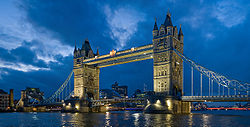
- Albert MemorialAlbert MemorialThe Albert Memorial is situated in Kensington Gardens, London, England, directly to the north of the Royal Albert Hall. It was commissioned by Queen Victoria in memory of her beloved husband, Prince Albert who died of typhoid in 1861. The memorial was designed by Sir George Gilbert Scott in the...
, London - Royal Albert HallRoyal Albert HallThe Royal Albert Hall is a concert hall situated on the northern edge of the South Kensington area, in the City of Westminster, London, England, best known for holding the annual summer Proms concerts since 1941....
, London - Victoria and Albert MuseumVictoria and Albert MuseumThe Victoria and Albert Museum , set in the Brompton district of The Royal Borough of Kensington and Chelsea, London, England, is the world's largest museum of decorative arts and design, housing a permanent collection of over 4.5 million objects...
, London - Battersea Power StationBattersea Power StationBattersea Power Station is a decommissioned coal-fired power station located on the south bank of the River Thames, in Battersea, South London. The station comprises two individual power stations, built in two stages in the form of a single building. Battersea A Power Station was built first in the...
, London - Euston TowerEuston TowerEuston Tower is a skyscraper located in the London Borough of Camden. It is a good example of an International style skyscraper with glass curtain walls. It is situated at the intersection of Tottenham Court Road/Hampstead Road and Euston Road. It stands across the Euston Road from Warren Street...
, London - Natural History MuseumNatural History MuseumThe Natural History Museum is one of three large museums on Exhibition Road, South Kensington, London, England . Its main frontage is on Cromwell Road...
, London - Science MuseumScience museumA science museum or a science centre is a museum devoted primarily to science. Older science museums tended to concentrate on static displays of objects related to natural history, paleontology, geology, industry and industrial machinery, etc. Modern trends in museology have broadened the range of...
, London - Regent's ParkRegent's ParkRegent's Park is one of the Royal Parks of London. It is in the north-western part of central London, partly in the City of Westminster and partly in the London Borough of Camden...
, London - Madame TussaudsMadame TussaudsMadame Tussauds is a wax museum in London with branches in a number of major cities. It was founded by wax sculptor Marie Tussaud and was formerly known as "Madame Tussaud's", but the apostrophe is no longer used...
, London - Hyde ParkHyde Park, LondonHyde Park is one of the largest parks in central London, United Kingdom, and one of the Royal Parks of London, famous for its Speakers' Corner.The park is divided in two by the Serpentine...
, London - Queen's HouseQueen's HouseThe Queen's House, Greenwich, is a former royal residence built between 1614-1617 in Greenwich, then a few miles downriver from London, and now a district of the city. Its architect was Inigo Jones, for whom it was a crucial early commission, for Anne of Denmark, the queen of King James I of England...
, London - Old Royal Naval CollegeOld Royal Naval CollegeThe Old Royal Naval College is the architectural centrepiece of Maritime Greenwich, a World Heritage Site in Greenwich, London, described by the United Nations Educational, Scientific and Cultural Organisation as being of “outstanding universal value” and reckoned to be the “finest and most...
, London - Smithfield Market, London
- Museum of LondonMuseum of LondonThe Museum of London documents the history of London from the Prehistoric to the present day. The museum is located close to the Barbican Centre, as part of the striking Barbican complex of buildings created in the 1960s and 70s as an innovative approach to re-development within a bomb damaged...
, London - Broadgate TowerBroadgate TowerThe Broadgate Tower is a skyscraper in London's main financial district, the City of London. It was constructed from 2005 to 2009 and is currently the fourth tallest building in the City of London....
, London - 99 Bishopsgate99 Bishopsgate99 Bishopsgate is a skyscraper in the City of London. It is tall and has 25 office floors, with a total net letable floor space of circa . There are a further three plant floors at levels LG, 14 and 27....
, London - One Churchill PlaceOne Churchill PlaceOne Churchill Place is a 156 m tall skyscraper with 32 floors, serving as the headquarters of Barclays Bank. It is in the Docklands area of London in Canary Wharf...
, London - 25 Bank Street25 Bank Street25 Bank Street is an office tower in the Canary Wharf business district of London. It was developed in 2001-2003 by Canary Wharf Group as one of five new buildings on its Heron Quays site...
, London - 40 Bank Street40 Bank Street40 Bank Street is a skyscraper in Heron Quays, Docklands, London. It is tall and has 33 floors. The building was designed by Cesar Pelli & Associates and it was built by Canary Wharf Contractors....
, London - 10 Upper Bank Street10 Upper Bank Street10 Upper Bank Street is a skyscraper in Canary Wharf, Docklands, London.It was designed by the architectural firm of Kohn Pedersen Fox and built by Canary Wharf Contractors.The 32 storey building was completed in 2003 and is 151 meters tall...
, London - Guy's TowerGuy's TowerGuy's Tower is a skyscraper located in the London Borough of Southwark. Completed in 1974 and standing more than 142 metres high, Guy's tower is the tallest hospital building in the world and a prominent example of Brutalist architecture....
, London - StrataStrata (building)Strata SE1 is a 148-metre, 43 storey, 408 flat skyscraper at Elephant and Castle in the London Borough of Southwark in London, England...
, London - 8 Canada Square, London
- 25 Canada Square, London
- One Canada SquareOne Canada SquareOne Canada Square is a skyscraper in Canary Wharf in the London Borough of Tower Hamlets. It is the tallest completed building in the United Kingdom since 1991, standing at above ground level and containing 50 storeys...
, London - Citigroup Centre, London
- Millennium DomeMillennium DomeThe Millennium Dome, colloquially referred to simply as The Dome or even The O2 Arena, is the original name of a large dome-shaped building, originally used to house the Millennium Experience, a major exhibition celebrating the beginning of the third millennium...
, The O2The O2 (London)The O2, visually typeset in branding as The O2, is a large entertainment district on the Greenwich peninsula in South East London, England, including an indoor arena, a music club, a Cineworld cinema, an exhibition space, piazzas, bars and restaurants...
, London - Ontario TowerOntario TowerThe Ontario Tower is a luxury high-rise residential development in London's Docklands. It was built by the Ballymore construction company, as part of a wider scheme in New Providence Wharf to provide new executive housing to meet changing demand in the Docklands area. 'Ontario' was designed by the...
, London - Manchester Town HallManchester Town HallManchester Town Hall is a Victorian-era, Neo-gothic municipal building in Manchester, England. The building functions as the ceremonial headquarters of Manchester City Council and houses a number of local government departments....
, ManchesterManchesterManchester is a city and metropolitan borough in Greater Manchester, England. According to the Office for National Statistics, the 2010 mid-year population estimate for Manchester was 498,800. Manchester lies within one of the UK's largest metropolitan areas, the metropolitan county of Greater...
, England - Bull Ring, BirminghamBirminghamBirmingham is a city and metropolitan borough in the West Midlands of England. It is the most populous British city outside the capital London, with a population of 1,036,900 , and lies at the heart of the West Midlands conurbation, the second most populous urban area in the United Kingdom with a...
, England - Humber BridgeHumber BridgeThe Humber Bridge, near Kingston upon Hull, England, is a 2,220 m single-span suspension bridge, which opened to traffic on 24 June 1981. It is the fifth-largest of its type in the world...
, BristolBristolBristol is a city, unitary authority area and ceremonial county in South West England, with an estimated population of 433,100 for the unitary authority in 2009, and a surrounding Larger Urban Zone with an estimated 1,070,000 residents in 2007...
, England - Liverpool CathedralLiverpool CathedralLiverpool Cathedral is the Church of England cathedral of the Diocese of Liverpool, built on St James's Mount in Liverpool and is the seat of the Bishop of Liverpool. Its official name is the Cathedral Church of Christ in Liverpool but it is dedicated to Christ and the Blessed Virgin...
, LiverpoolLiverpoolLiverpool is a city and metropolitan borough of Merseyside, England, along the eastern side of the Mersey Estuary. It was founded as a borough in 1207 and was granted city status in 1880...
, England - Royal Liver BuildingRoyal Liver BuildingThe Royal Liver Building is a Grade I listed building located in Liverpool, England. It is sited at the Pier Head and along with the neighbouring Cunard Building and Port of Liverpool Building is one of Liverpool's Three Graces, which line the city's waterfront...
, LiverpoolLiverpoolLiverpool is a city and metropolitan borough of Merseyside, England, along the eastern side of the Mersey Estuary. It was founded as a borough in 1207 and was granted city status in 1880...
, England - Cunard BuildingCunard BuildingThe Cunard Building is a Grade II* listed building located in Liverpool, England. It is sited at the Pier Head and along with the neighbouring Liver Building and Port of Liverpool Building is one of Liverpool's Three Graces, which line the city's waterfront...
, LiverpoolLiverpoolLiverpool is a city and metropolitan borough of Merseyside, England, along the eastern side of the Mersey Estuary. It was founded as a borough in 1207 and was granted city status in 1880...
, England - Port of Liverpool BuildingPort of Liverpool BuildingThe Port of Liverpool Building , is a Grade II* listed building located in Liverpool, England. It is sited at the Pier Head and along with the neighbouring Liver Building and Cunard Building is one of Liverpool's "Three Graces", which line the city's waterfront...
, LiverpoolLiverpoolLiverpool is a city and metropolitan borough of Merseyside, England, along the eastern side of the Mersey Estuary. It was founded as a borough in 1207 and was granted city status in 1880...
, England - Spinnaker TowerSpinnaker TowerSpinnaker Tower is a –high landmark tower in Portsmouth, England. It is the centrepiece of the redevelopment of Portsmouth Harbour, which was supported by a National Lottery grant. Its shape was chosen by Portsmouth residents from a selection of concepts...
with Gunwharf QuaysGunwharf QuaysGunwharf Quays is an area of Portsmouth, Hampshire, now home to a large shopping centre.- History:The centre opened on 28 February 2001 and is located on the site of the former Royal Navy shore establishment HMS Vernon, renamed HMS Nelson on March 31, 1986...
PortsmouthPortsmouthPortsmouth is the second largest city in the ceremonial county of Hampshire on the south coast of England. Portsmouth is notable for being the United Kingdom's only island city; it is located mainly on Portsea Island...
, England - Shakespeare's BirthplaceShakespeare's BirthplaceShakespeare's Birthplace is a carefully restored 16th century half-timbered house situated in Henley Street, Stratford-upon-Avon, Warwickshire, England, where it is believed that William Shakespeare was born in 1564 and spent his childhood years. It is now a small museum open to the public and is a...
, Stratford-upon-AvonStratford-upon-AvonStratford-upon-Avon is a market town and civil parish in south Warwickshire, England. It lies on the River Avon, south east of Birmingham and south west of Warwick. It is the largest and most populous town of the District of Stratford-on-Avon, which uses the term "on" to indicate that it covers...
, England - Hall's CroftHall's CroftHall's Croft, Stratford-upon-Avon, Warwickshire, England, was owned by William Shakespeare's daughter, Susanna Hall, and her husband Dr John Hall whom she married in 1607....
, Stratford-upon-AvonStratford-upon-AvonStratford-upon-Avon is a market town and civil parish in south Warwickshire, England. It lies on the River Avon, south east of Birmingham and south west of Warwick. It is the largest and most populous town of the District of Stratford-on-Avon, which uses the term "on" to indicate that it covers...
, England - Nash's HouseNash's HouseNash's House, Chapel Street, Stratford-upon-Avon, Warwickshire, England is the house next door to the ruins and gardens of William Shakespeare's final residence, New Place. It has been converted into a museum. The museum traces the history of Stratford-upon-Avon from the earliest settlers in the...
and New PlaceNew PlaceNew Place is the name of William Shakespeare's final place of residence in Stratford-upon-Avon. He died there in 1616. Though the house no longer exists, the land is owned by the Shakespeare Birthplace Trust....
, Stratford-upon-AvonStratford-upon-AvonStratford-upon-Avon is a market town and civil parish in south Warwickshire, England. It lies on the River Avon, south east of Birmingham and south west of Warwick. It is the largest and most populous town of the District of Stratford-on-Avon, which uses the term "on" to indicate that it covers...
, England - Anne Hathaway's CottageAnne Hathaway's CottageAnne Hathaway's Cottage is the former childhood home of Anne Hathaway, the wife of William Shakespeare. The house is situated in village of Shottery, Warwickshire, England, and about west of Stratford-upon-Avon....
, ShotteryShotteryShottery is a small village a mile west of Stratford-Upon-Avon; nowadays, it is considered a part of the town, but it retains the feeling of a distinct village.-History and amenities:...
, England - Roman Baths, Bath, England
- Royal CrescentRoyal CrescentThe Royal Crescent is a residential road of 30 houses laid out in a crescent in the city of Bath, England. Designed by the architect John Wood the Younger and built between 1767 and 1774, it is among the greatest examples of Georgian architecture to be found in the United Kingdom and is a grade I...
, Bath, England - Wells CathedralWells CathedralWells Cathedral is a Church of England cathedral in Wells, Somerset, England. It is the seat of the Bishop of Bath and Wells, who lives at the adjacent Bishop's Palace....
, WellsWellsWells is a cathedral city and civil parish in the Mendip district of Somerset, England, on the southern edge of the Mendip Hills. Although the population recorded in the 2001 census is 10,406, it has had city status since 1205...
, England - LongleatLongleatLongleat is an English stately home, currently the seat of the Marquesses of Bath, adjacent to the village of Horningsham and near the towns of Warminster in Wiltshire and Frome in Somerset. It is noted for its Elizabethan country house, maze, landscaped parkland and safari park. The house is set...
, HorningshamHorningshamHorningsham is a small Wiltshire village forming part of the Longleat Estate and lying on the Wiltshire/Somerset border between Warminster and Frome.It has a peculiar form lying somwehere between a classic dispersed settlement and a nucleated village....
, England - Salisbury CathedralSalisbury CathedralSalisbury Cathedral, formally known as the Cathedral Church of the Blessed Virgin Mary, is an Anglican cathedral in Salisbury, England, considered one of the leading examples of Early English architecture....
, SalisburySalisburySalisbury is a cathedral city in Wiltshire, England and the only city in the county. It is the second largest settlement in the county...
, England
- StonehengeStonehengeStonehenge is a prehistoric monument located in the English county of Wiltshire, about west of Amesbury and north of Salisbury. One of the most famous sites in the world, Stonehenge is composed of a circular setting of large standing stones set within earthworks...
, WiltshireWiltshireWiltshire is a ceremonial county in South West England. It is landlocked and borders the counties of Dorset, Somerset, Hampshire, Gloucestershire, Oxfordshire and Berkshire. It contains the unitary authority of Swindon and covers...
, England - Clifton Suspension BridgeClifton Suspension BridgeBrunel died in 1859, without seeing the completion of the bridge. Brunel's colleagues in the Institution of Civil Engineers felt that completion of the Bridge would be a fitting memorial, and started to raise new funds...
, BristolBristolBristol is a city, unitary authority area and ceremonial county in South West England, with an estimated population of 433,100 for the unitary authority in 2009, and a surrounding Larger Urban Zone with an estimated 1,070,000 residents in 2007...
, England - Severn BridgeSevern BridgeThe Severn Bridge is a suspension bridge spanning the River Severn between South Gloucestershire, just north of Bristol, England, and Monmouthshire in South Wales, via Beachley, a peninsula between the River Severn and River Wye estuary. It is the original Severn road crossing between England and...
, England/Wales - Mentmore TowersMentmore TowersMentmore Towers is a 19th century English country house in the village of Mentmore in Buckinghamshire. The house was designed by Joseph Paxton and his son-in-law, George Henry Stokes, in the revival Elizabethan and Jacobean style of the late 16th century called Jacobethan, for the banker and...
, MentmoreMentmoreMentmore is a village and civil parish in the Aylesbury Vale district of Buckinghamshire, England. It is about three miles east of Wingrave, three miles south east of Wing.The village toponym is derived from the Old English for "Menta's moor"...
, England - Eden ProjectEden ProjectThe Eden Project is a visitor attraction in Cornwall in the United Kingdom, including the world's largest greenhouse. Inside the artificial biomes are plants that are collected from all around the world....
, St BlazeySt BlazeySt Blazey is a small town in Cornwall, United Kingdom.St Blaise is the civil parish in which St Blazey is situated; the name St Blaise is also used by the town council.St Blazey is situated east of St Austell...
, England - Radcliffe CameraRadcliffe CameraThe Radcliffe Camera is a building in Oxford, England, designed by James Gibbs in the English Palladian style and built in 1737–1749 to house the Radcliffe Science Library.-History:...
, OxfordOxfordThe city of Oxford is the county town of Oxfordshire, England. The city, made prominent by its medieval university, has a population of just under 165,000, with 153,900 living within the district boundary. It lies about 50 miles north-west of London. The rivers Cherwell and Thames run through...
, England - Dover CastleDover CastleDover Castle is a medieval castle in the town of the same name in the English county of Kent. It was founded in the 12th century and has been described as the "Key to England" due to its defensive significance throughout history...
, DoverDoverDover is a town and major ferry port in the home county of Kent, in South East England. It faces France across the narrowest part of the English Channel, and lies south-east of Canterbury; east of Kent's administrative capital Maidstone; and north-east along the coastline from Dungeness and Hastings...
, England - King's College ChapelKing's College Chapel, CambridgeKing's College Chapel is the chapel to King's College of the University of Cambridge, and is one of the finest examples of late Gothic English architecture, while its early Renaissance rood screen separating the nave and chancel, erected in 1532-36 in a striking contrast of style, has been called...
, CambridgeCambridgeThe city of Cambridge is a university town and the administrative centre of the county of Cambridgeshire, England. It lies in East Anglia about north of London. Cambridge is at the heart of the high-technology centre known as Silicon Fen – a play on Silicon Valley and the fens surrounding the...
, England - Lincoln CathedralLincoln CathedralLincoln Cathedral is a historic Anglican cathedral in Lincoln in England and seat of the Bishop of Lincoln in the Church of England. It was reputedly the tallest building in the world for 249 years . The central spire collapsed in 1549 and was not rebuilt...
, LincolnLincoln, LincolnshireLincoln is a cathedral city and county town of Lincolnshire, England.The non-metropolitan district of Lincoln has a population of 85,595; the 2001 census gave the entire area of Lincoln a population of 120,779....
, England - Durham CastleDurham CastleDurham Castle is a Norman castle in the city of Durham, England, which has been wholly occupied since 1840 by University College, Durham. It is open to the general public to visit, but only through guided tours, since it is in use as a working building and is home to over 100 students...
and Durham CathedralDurham CathedralThe Cathedral Church of Christ, Blessed Mary the Virgin and St Cuthbert of Durham is a cathedral in the city of Durham, England, the seat of the Anglican Bishop of Durham. The Bishopric dates from 995, with the present cathedral being founded in AD 1093...
, DurhamDurhamDurham is a city in north east England. It is within the County Durham local government district, and is the county town of the larger ceremonial county...
, England - Gateshead Millennium BridgeGateshead Millennium BridgeThe Gateshead Millennium Bridge is a pedestrian and cyclist tilt bridge spanning the River Tyne in England between Gateshead's Quays arts quarter on the south bank, and the Quayside of Newcastle upon Tyne on the north bank. The award-winning structure was conceived and designed by architects...
, Newcastle upon TyneNewcastle upon TyneNewcastle upon Tyne is a city and metropolitan borough of Tyne and Wear, in North East England. Historically a part of Northumberland, it is situated on the north bank of the River Tyne...
, England - The Sage Gateshead, Newcastle upon TyneNewcastle upon TyneNewcastle upon Tyne is a city and metropolitan borough of Tyne and Wear, in North East England. Historically a part of Northumberland, it is situated on the north bank of the River Tyne...
, England - Tyne BridgeTyne BridgeThe Tyne Bridge is a through arch bridge over the River Tyne in North East England, linking Newcastle upon Tyne and Gateshead. It was designed by the engineering firm Mott, Hay and Anderson, who later designed the Forth Road Bridge, and was built by Dorman Long and Co. of Middlesbrough. At the time...
, Newcastle upon TyneNewcastle upon TyneNewcastle upon Tyne is a city and metropolitan borough of Tyne and Wear, in North East England. Historically a part of Northumberland, it is situated on the north bank of the River Tyne...
, England - Angel of the NorthAngel of the NorthThe Angel of the North is a contemporary sculpture, designed by Antony Gormley, which is located in Gateshead,formerly County Durham, England.It is a steel sculpture of an angel, standing tall, with wings measuring across...
, GatesheadGatesheadGateshead is a town in Tyne and Wear, England and is the main settlement in the Metropolitan Borough of Gateshead. Historically a part of County Durham, it lies on the southern bank of the River Tyne opposite Newcastle upon Tyne and together they form the urban core of Tyneside...
, England - Clyde AuditoriumClyde AuditoriumThe Clyde Auditorium, familiarly known as "The Armadillo", is an iconic concert venue in Glasgow, Scotland. The building sits on the site of the now infilled Queen's Dock on the River Clyde, adjacent to the Scottish Exhibition and Conference Centre....
, "The Armadillo", GlasgowGlasgowGlasgow is the largest city in Scotland and third most populous in the United Kingdom. The city is situated on the River Clyde in the country's west central lowlands...
, ScotlandScotlandScotland is a country that is part of the United Kingdom. Occupying the northern third of the island of Great Britain, it shares a border with England to the south and is bounded by the North Sea to the east, the Atlantic Ocean to the north and west, and the North Channel and Irish Sea to the... - Royal MileRoyal MileThe Royal Mile is a succession of streets which form the main thoroughfare of the Old Town of the city of Edinburgh in Scotland.As the name suggests, the Royal Mile is approximately one Scots mile long, and runs between two foci of history in Scotland, from Edinburgh Castle at the top of the Castle...
, EdinburghEdinburghEdinburgh is the capital city of Scotland, the second largest city in Scotland, and the eighth most populous in the United Kingdom. The City of Edinburgh Council governs one of Scotland's 32 local government council areas. The council area includes urban Edinburgh and a rural area...
, ScotlandScotlandScotland is a country that is part of the United Kingdom. Occupying the northern third of the island of Great Britain, it shares a border with England to the south and is bounded by the North Sea to the east, the Atlantic Ocean to the north and west, and the North Channel and Irish Sea to the... - Calton Hill, EdinburghEdinburghEdinburgh is the capital city of Scotland, the second largest city in Scotland, and the eighth most populous in the United Kingdom. The City of Edinburgh Council governs one of Scotland's 32 local government council areas. The council area includes urban Edinburgh and a rural area...
, ScotlandScotlandScotland is a country that is part of the United Kingdom. Occupying the northern third of the island of Great Britain, it shares a border with England to the south and is bounded by the North Sea to the east, the Atlantic Ocean to the north and west, and the North Channel and Irish Sea to the... - Stirling CastleStirling CastleStirling Castle, located in Stirling, is one of the largest and most important castles, both historically and architecturally, in Scotland. The castle sits atop Castle Hill, an intrusive crag, which forms part of the Stirling Sill geological formation. It is surrounded on three sides by steep...
, StirlingStirlingStirling is a city and former ancient burgh in Scotland, and is at the heart of the wider Stirling council area. The city is clustered around a large fortress and medieval old-town beside the River Forth...
, ScotlandScotlandScotland is a country that is part of the United Kingdom. Occupying the northern third of the island of Great Britain, it shares a border with England to the south and is bounded by the North Sea to the east, the Atlantic Ocean to the north and west, and the North Channel and Irish Sea to the... - Forth Railway Bridge, ScotlandScotlandScotland is a country that is part of the United Kingdom. Occupying the northern third of the island of Great Britain, it shares a border with England to the south and is bounded by the North Sea to the east, the Atlantic Ocean to the north and west, and the North Channel and Irish Sea to the...
- Pontcysyllte AqueductPontcysyllte AqueductThe Pontcysyllte Aqueduct is a navigable aqueduct that carries the Llangollen Canal over the valley of the River Dee in Wrexham in north east Wales....
, WrexhamWrexhamWrexham is a town in Wales. It is the administrative centre of the wider Wrexham County Borough, and the largest town in North Wales, located in the east of the region. It is situated between the Welsh mountains and the lower Dee Valley close to the border with Cheshire, England...
, WalesWalesWales is a country that is part of the United Kingdom and the island of Great Britain, bordered by England to its east and the Atlantic Ocean and Irish Sea to its west. It has a population of three million, and a total area of 20,779 km²... - Caerphilly CastleCaerphilly CastleCaerphilly Castle is a medieval castle that dominates the centre of the town of Caerphilly in south Wales. It is the largest castle in Wales and the second largest in Britain after Windsor Castle...
, CaerphillyCaerphillyCaerphilly is a town in the county borough of Caerphilly, south Wales, located at the southern end of the Rhymney Valley, with a population of approximately 31,000. It is a commuter town of Cardiff and Newport, which are located some 7.5 miles and 12 miles away, respectively...
, WalesWalesWales is a country that is part of the United Kingdom and the island of Great Britain, bordered by England to its east and the Atlantic Ocean and Irish Sea to its west. It has a population of three million, and a total area of 20,779 km²... - Cardiff CastleCardiff CastleCardiff Castle is a medieval castle and Victorian architecture Gothic revival mansion, transformed from a Norman keep erected over a Roman fort in the Castle Quarter of Cardiff, the capital of Wales. The Castle is a Grade I Listed Building.-The Roman fort:...
, CardiffCardiffCardiff is the capital, largest city and most populous county of Wales and the 10th largest city in the United Kingdom. The city is Wales' chief commercial centre, the base for most national cultural and sporting institutions, the Welsh national media, and the seat of the National Assembly for...
, WalesWalesWales is a country that is part of the United Kingdom and the island of Great Britain, bordered by England to its east and the Atlantic Ocean and Irish Sea to its west. It has a population of three million, and a total area of 20,779 km²... - Millennium StadiumMillennium StadiumThe Millennium Stadium is the national stadium of Wales, located in the capital, Cardiff. It is the home of the Wales national rugby union team and also frequently stages games of the Wales national football team, but is also host to many other large scale events, such as the Super Special Stage...
, CardiffCardiffCardiff is the capital, largest city and most populous county of Wales and the 10th largest city in the United Kingdom. The city is Wales' chief commercial centre, the base for most national cultural and sporting institutions, the Welsh national media, and the seat of the National Assembly for...
, WalesWalesWales is a country that is part of the United Kingdom and the island of Great Britain, bordered by England to its east and the Atlantic Ocean and Irish Sea to its west. It has a population of three million, and a total area of 20,779 km²... - Wales Millennium CentreWales Millennium CentreWales Millennium Centre is an arts centre located in the Cardiff Bay area of Cardiff, Wales. The site covers a total area of . Phase 1 of the building was opened during the weekend of the 26–28 November 2004 and phase 2 opened on 22 January 2009 with an inaugural concert...
, CardiffCardiffCardiff is the capital, largest city and most populous county of Wales and the 10th largest city in the United Kingdom. The city is Wales' chief commercial centre, the base for most national cultural and sporting institutions, the Welsh national media, and the seat of the National Assembly for...
, WalesWalesWales is a country that is part of the United Kingdom and the island of Great Britain, bordered by England to its east and the Atlantic Ocean and Irish Sea to its west. It has a population of three million, and a total area of 20,779 km²... - Pierhead BuildingPierhead BuildingThe Pierhead Building is a Grade 1 listed building of the National Assembly for Wales in Cardiff Bay, Wales. It stands as one of the city of Cardiff's most familiar landmarks and was built in 1897 as the headquarters for the Bute Dock Company....
, CardiffCardiffCardiff is the capital, largest city and most populous county of Wales and the 10th largest city in the United Kingdom. The city is Wales' chief commercial centre, the base for most national cultural and sporting institutions, the Welsh national media, and the seat of the National Assembly for...
, WalesWalesWales is a country that is part of the United Kingdom and the island of Great Britain, bordered by England to its east and the Atlantic Ocean and Irish Sea to its west. It has a population of three million, and a total area of 20,779 km²...
Belize
- Altun HaAltun HaAltun Ha is the name given ruins of an ancient Maya city in Belize, located in the Belize District about 30 miles north of Belize City and about 6 miles west of the shore of the Caribbean Sea....
, BelizeBelize DistrictThe Belize District is a district of the nation of Belize, with its district capital being the nation's largest city, Belize City.- Settlements :... - LamanaiLamanaiLamanai is a Mesoamerican archaeological site, and was once a considerably sized city of the Maya civilization, located in the north of Belize, in Orange Walk District...
, Orange WalkOrange Walk DistrictOrange Walk District is a district in the northwest of the nation of Belize, with its district capital in Orange Walk Town.- Main settlements :... - CaracolCaracolCaracol is the name given to a large ancient Maya archaeological site, located in what is now the Cayo District of Belize. It is situated approximately 40 kilometres south of Xunantunich and the town of San Ignacio Cayo, and 15 kilometers away from the Macal River. It rests on the Vaca Plateau at...
, CayoCayo DistrictCayo District is a district in the west of the nation of Belize. The District capital is the town of San Ignacio.- Geography :The Cayo District is the largest district in Belize. It is located on the western side of the country which borders Guatemala. The nation's capital, Belmopan, is...
Canada
- L'Anse aux MeadowsL'Anse aux MeadowsL'Anse aux Meadows is an archaeological site on the northernmost tip of the island of Newfoundland in the Canadian province of Newfoundland and Labrador. Discovered in 1960, it is the only known site of a Norse or Viking village in Canada, and in North America outside of Greenland...
, Newfoundland and LabradorNewfoundland and LabradorNewfoundland and Labrador is the easternmost province of Canada. Situated in the country's Atlantic region, it incorporates the island of Newfoundland and mainland Labrador with a combined area of . As of April 2011, the province's estimated population is 508,400... - Old Town LunenburgLunenburg, Nova ScotiaLunenburg , is a Canadian port town in Lunenburg County, Nova Scotia.Situated on the province's South Shore, Lunenburg is located on a peninsula at the western side of Mahone Bay. The town is approximately 90 kilometres southwest of the county boundary with the Halifax Regional Municipality.The...
, Nova ScotiaNova ScotiaNova Scotia is one of Canada's three Maritime provinces and is the most populous province in Atlantic Canada. The name of the province is Latin for "New Scotland," but "Nova Scotia" is the recognized, English-language name of the province. The provincial capital is Halifax. Nova Scotia is the... - Old QuebecOld QuebecOld Quebec is a historic neighbourhood of Quebec City, the capital of the province of Quebec in Canada. Comprising the Upper Town and Lower Town , the area is a UNESCO World Heritage Site...
, Quebec CityQuebec CityQuebec , also Québec, Quebec City or Québec City is the capital of the Canadian province of Quebec and is located within the Capitale-Nationale region. It is the second most populous city in Quebec after Montreal, which is about to the southwest...
, QuebecQuebecQuebec or is a province in east-central Canada. It is the only Canadian province with a predominantly French-speaking population and the only one whose sole official language is French at the provincial level.... - Château FrontenacChâteau FrontenacThe Château Frontenac, currently known as Fairmont Le Château Frontenac, is a grand hotel in Quebec City, Quebec, Canada. It was designated a National Historic Site of Canada in 1980...
, Quebec CityQuebec CityQuebec , also Québec, Quebec City or Québec City is the capital of the Canadian province of Quebec and is located within the Capitale-Nationale region. It is the second most populous city in Quebec after Montreal, which is about to the southwest...
, QuebecQuebecQuebec or is a province in east-central Canada. It is the only Canadian province with a predominantly French-speaking population and the only one whose sole official language is French at the provincial level.... - Mount RoyalMount RoyalMount Royal is a mountain in the city of Montreal, immediately west of downtown Montreal, Quebec, Canada, the city to which it gave its name.The mountain is part of the Monteregian Hills situated between the Laurentians and the Appalachians...
, MontrealMontrealMontreal is a city in Canada. It is the largest city in the province of Quebec, the second-largest city in Canada and the seventh largest in North America...
, QuebecQuebecQuebec or is a province in east-central Canada. It is the only Canadian province with a predominantly French-speaking population and the only one whose sole official language is French at the provincial level.... - Notre-Dame Basilica (Montreal)Notre-Dame Basilica (Montreal)Notre-Dame Basilica is a basilica in the historic district of Old Montreal, in Montreal, Quebec, Canada. The church is located at 110 Notre-Dame Street West, at the corner of Saint Sulpice Street...
, MontrealMontrealMontreal is a city in Canada. It is the largest city in the province of Quebec, the second-largest city in Canada and the seventh largest in North America...
, QuebecQuebecQuebec or is a province in east-central Canada. It is the only Canadian province with a predominantly French-speaking population and the only one whose sole official language is French at the provincial level.... - Saint Joseph's OratorySaint Joseph's OratorySaint Joseph's Oratory of Mount Royal, , is a Roman Catholic minor basilica and national shrine on the west slope of Mount Royal in Montreal, Quebec, Canada.-History:...
, MontrealMontrealMontreal is a city in Canada. It is the largest city in the province of Quebec, the second-largest city in Canada and the seventh largest in North America...
, QuebecQuebecQuebec or is a province in east-central Canada. It is the only Canadian province with a predominantly French-speaking population and the only one whose sole official language is French at the provincial level.... - Habitat 67 and Montreal BiosphèreMontreal BiosphèreThe Biosphère is a museum in Montreal dedicated to the environment. It is located at Parc Jean-Drapeau, on Île Sainte-Hélène in the former pavilion of the United States for the 1967 World Fair Expo 67.- Expo 67 :...
, Montreal, Quebec - Underground CityUnderground cityAn Underground city is a series of linked subterranean spaces that may provide a defensive refuge; a place for living, working or shopping; a transit system; mausolea; wine or storage cellars; cisterns or drainage channels; or several of these. The term may also refer to a network of tunnels that...
, Montreal, Quebec - Place des ArtsPlace des Artsright|frame|View of the Place des Arts esplanade. The Musée d'art contemporain is on the left; behind it is the Salle Wilfrid-Pelletier, with the Théâtre Maisonneuve on the rightPlace des Arts is a major performing arts centre in Montreal, Quebec, Canada....
, Montreal, Quebec - Place Ville-MariePlace Ville-Marie1 Place Ville-Marie , formerly Royal Bank Tower taken from its anchor tenant, is a with 47-storey, cruciform office tower built in the International style in 1962, arguably the most distinctive building in Montreal, Quebec, Canada. It was built in the 1960s as the headquarters of the Royal Bank of...
, Montreal, Quebec - Parliament HillParliament HillParliament Hill , colloquially known as The Hill, is an area of Crown land on the southern banks of the Ottawa River in downtown Ottawa, Ontario. Its Gothic revival suite of buildingsthe parliament buildings serves as the home of the Parliament of Canada and contains a number of architectural...
, OttawaOttawaOttawa is the capital of Canada, the second largest city in the Province of Ontario, and the fourth largest city in the country. The city is located on the south bank of the Ottawa River in the eastern portion of Southern Ontario...
, OntarioOntarioOntario is a province of Canada, located in east-central Canada. It is Canada's most populous province and second largest in total area. It is home to the nation's most populous city, Toronto, and the nation's capital, Ottawa.... - Rideau CanalRideau CanalThe Rideau Canal , also known as the Rideau Waterway, connects the city of Ottawa, Ontario, Canada on the Ottawa River to the city of Kingston, Ontario on Lake Ontario. The canal was opened in 1832 as a precaution in case of war with the United States and is still in use today, with most of its...
, OntarioOntarioOntario is a province of Canada, located in east-central Canada. It is Canada's most populous province and second largest in total area. It is home to the nation's most populous city, Toronto, and the nation's capital, Ottawa.... - Rideau HallRideau HallRideau Hall is, since 1867, the official residence in Ottawa of both the Canadian monarch and the Governor General of Canada. It stands in Canada's capital on a 0.36 km2 estate at 1 Sussex Drive, with the main building consisting of 170 rooms across 9,500 m2 , and 24 outbuildings around the...
, OttawaOttawaOttawa is the capital of Canada, the second largest city in the Province of Ontario, and the fourth largest city in the country. The city is located on the south bank of the Ottawa River in the eastern portion of Southern Ontario...
, OntarioOntarioOntario is a province of Canada, located in east-central Canada. It is Canada's most populous province and second largest in total area. It is home to the nation's most populous city, Toronto, and the nation's capital, Ottawa.... - Casa LomaCasa LomaCasa Loma is a Gothic Revival style house in midtown Toronto, Ontario, Canada, that is now a museum and landmark. It was originally a residence for financier Sir Henry Mill Pellatt. Casa Loma was constructed over a three-year period from 1911–1914. The architect of the mansion was E. J...
, TorontoTorontoToronto is the provincial capital of Ontario and the largest city in Canada. It is located in Southern Ontario on the northwestern shore of Lake Ontario. A relatively modern city, Toronto's history dates back to the late-18th century, when its land was first purchased by the British monarchy from...
, OntarioOntarioOntario is a province of Canada, located in east-central Canada. It is Canada's most populous province and second largest in total area. It is home to the nation's most populous city, Toronto, and the nation's capital, Ottawa.... - CN TowerCN TowerThe CN Tower is a communications and observation tower in Downtown Toronto, Ontario, Canada. Standing tall, it was completed in 1976, becoming the world's tallest free-standing structure and world's tallest tower at the time. It held both records for 34 years until the completion of the Burj...
, TorontoTorontoToronto is the provincial capital of Ontario and the largest city in Canada. It is located in Southern Ontario on the northwestern shore of Lake Ontario. A relatively modern city, Toronto's history dates back to the late-18th century, when its land was first purchased by the British monarchy from...
, OntarioOntarioOntario is a province of Canada, located in east-central Canada. It is Canada's most populous province and second largest in total area. It is home to the nation's most populous city, Toronto, and the nation's capital, Ottawa.... - Toronto Eaton CentreToronto Eaton CentreThe Toronto Eaton Centre is a large shopping mall and office complex in downtown Toronto, Ontario, Canada, named after the now-defunct Eaton's department store chain that once anchored it. In terms of the number of visitors, the shopping mall is Toronto's top tourist attraction, with around one...
, TorontoTorontoToronto is the provincial capital of Ontario and the largest city in Canada. It is located in Southern Ontario on the northwestern shore of Lake Ontario. A relatively modern city, Toronto's history dates back to the late-18th century, when its land was first purchased by the British monarchy from...
, OntarioOntarioOntario is a province of Canada, located in east-central Canada. It is Canada's most populous province and second largest in total area. It is home to the nation's most populous city, Toronto, and the nation's capital, Ottawa.... - Exhibition PlaceExhibition PlaceExhibition Place is a mixed-use district in Toronto, Ontario, Canada, by the shoreline of Lake Ontario, just west of downtown. The 197–acre area includes expo, trade, and banquet centres, theatre and music buildings, monuments, parkland, sports facilities, and a number of civic, provincial,...
, TorontoTorontoToronto is the provincial capital of Ontario and the largest city in Canada. It is located in Southern Ontario on the northwestern shore of Lake Ontario. A relatively modern city, Toronto's history dates back to the late-18th century, when its land was first purchased by the British monarchy from...
, OntarioOntarioOntario is a province of Canada, located in east-central Canada. It is Canada's most populous province and second largest in total area. It is home to the nation's most populous city, Toronto, and the nation's capital, Ottawa.... - Harbourfront CentreHarbourfront CentreHarbourfront Centre is a key cultural organization on Toronto, Ontario's waterfront, situated at 235 Queen's Quay West. Established as a crown corporation in 1972 by the federal government to create a waterfront park, it became a non-profit organization in 1991. Funding comes from corporate...
, TorontoTorontoToronto is the provincial capital of Ontario and the largest city in Canada. It is located in Southern Ontario on the northwestern shore of Lake Ontario. A relatively modern city, Toronto's history dates back to the late-18th century, when its land was first purchased by the British monarchy from...
, OntarioOntarioOntario is a province of Canada, located in east-central Canada. It is Canada's most populous province and second largest in total area. It is home to the nation's most populous city, Toronto, and the nation's capital, Ottawa.... - Yonge-Dundas Square, TorontoTorontoToronto is the provincial capital of Ontario and the largest city in Canada. It is located in Southern Ontario on the northwestern shore of Lake Ontario. A relatively modern city, Toronto's history dates back to the late-18th century, when its land was first purchased by the British monarchy from...
, OntarioOntarioOntario is a province of Canada, located in east-central Canada. It is Canada's most populous province and second largest in total area. It is home to the nation's most populous city, Toronto, and the nation's capital, Ottawa.... - Toronto City HallToronto City HallThe City Hall of Toronto, Ontario, Canada is the home of the city's municipal government and one of its most distinctive landmarks. Designed by Finnish architect Viljo Revell and landscape architect Richard Strong, and engineered by Hannskarl Bandel, the building opened in 1965...
, TorontoTorontoToronto is the provincial capital of Ontario and the largest city in Canada. It is located in Southern Ontario on the northwestern shore of Lake Ontario. A relatively modern city, Toronto's history dates back to the late-18th century, when its land was first purchased by the British monarchy from...
, OntarioOntarioOntario is a province of Canada, located in east-central Canada. It is Canada's most populous province and second largest in total area. It is home to the nation's most populous city, Toronto, and the nation's capital, Ottawa.... - Brookfield Place, TorontoTorontoToronto is the provincial capital of Ontario and the largest city in Canada. It is located in Southern Ontario on the northwestern shore of Lake Ontario. A relatively modern city, Toronto's history dates back to the late-18th century, when its land was first purchased by the British monarchy from...
, OntarioOntarioOntario is a province of Canada, located in east-central Canada. It is Canada's most populous province and second largest in total area. It is home to the nation's most populous city, Toronto, and the nation's capital, Ottawa.... - Toronto Dominion Centre, TorontoTorontoToronto is the provincial capital of Ontario and the largest city in Canada. It is located in Southern Ontario on the northwestern shore of Lake Ontario. A relatively modern city, Toronto's history dates back to the late-18th century, when its land was first purchased by the British monarchy from...
, OntarioOntarioOntario is a province of Canada, located in east-central Canada. It is Canada's most populous province and second largest in total area. It is home to the nation's most populous city, Toronto, and the nation's capital, Ottawa.... - The Forks, WinnipegWinnipegWinnipeg is the capital and largest city of Manitoba, Canada, and is the primary municipality of the Winnipeg Capital Region, with more than half of Manitoba's population. It is located near the longitudinal centre of North America, at the confluence of the Red and Assiniboine Rivers .The name...
, ManitobaManitobaManitoba is a Canadian prairie province with an area of . The province has over 110,000 lakes and has a largely continental climate because of its flat topography. Agriculture, mostly concentrated in the fertile southern and western parts of the province, is vital to the province's economy; other... - Calgary TowerCalgary TowerThe Calgary Tower is a 191 metre free standing observation tower in Downtown Calgary, Alberta, Canada. Originally called the Husky Tower, it was conceived as a joint venture between Marathon Realty Company Limited and Husky Oil as part of an urban renewal plan and to celebrate Canada's centennial...
, CalgaryCalgaryCalgary is a city in the Province of Alberta, Canada. It is located in the south of the province, in an area of foothills and prairie, approximately east of the front ranges of the Canadian Rockies...
, AlbertaAlbertaAlberta is a province of Canada. It had an estimated population of 3.7 million in 2010 making it the most populous of Canada's three prairie provinces... - The Fairmont Banff Springs Hotel, BanffBanff National ParkBanff National Park is Canada's oldest national park, established in 1885 in the Rocky Mountains. The park, located 110–180 kilometres west of Calgary in the province of Alberta, encompasses of mountainous terrain, with numerous glaciers and ice fields, dense coniferous forest, and alpine...
, AlbertaAlbertaAlberta is a province of Canada. It had an estimated population of 3.7 million in 2010 making it the most populous of Canada's three prairie provinces... - Canada PlaceCanada PlaceCanada Place is a building situated on the Burrard Inlet waterfront of Vancouver, British Columbia. It is the home of the Vancouver Convention Centre, the Pan Pacific Hotel, Vancouver's World Trade Centre, and the world's first permanent IMAX 3D theatre . The building's exterior is covered by...
, VancouverVancouverVancouver is a coastal seaport city on the mainland of British Columbia, Canada. It is the hub of Greater Vancouver, which, with over 2.3 million residents, is the third most populous metropolitan area in the country,...
, British ColumbiaBritish ColumbiaBritish Columbia is the westernmost of Canada's provinces and is known for its natural beauty, as reflected in its Latin motto, Splendor sine occasu . Its name was chosen by Queen Victoria in 1858... - Lions Gate Bridge, West Vancouver, British ColumbiaBritish ColumbiaBritish Columbia is the westernmost of Canada's provinces and is known for its natural beauty, as reflected in its Latin motto, Splendor sine occasu . Its name was chosen by Queen Victoria in 1858...
- Science World, VancouverVancouverVancouver is a coastal seaport city on the mainland of British Columbia, Canada. It is the hub of Greater Vancouver, which, with over 2.3 million residents, is the third most populous metropolitan area in the country,...
, British Columbia - Harbour Center, Vancouver, British Columbia
- Granville IslandGranville IslandGranville Island is a peninsula and shopping district in Vancouver, British Columbia, Canada. It is located in False Creek directly across from Downtown Vancouver's peninsula, under the south end of the Granville Street Bridge....
, VancouverVancouverVancouver is a coastal seaport city on the mainland of British Columbia, Canada. It is the hub of Greater Vancouver, which, with over 2.3 million residents, is the third most populous metropolitan area in the country,...
, British ColumbiaBritish ColumbiaBritish Columbia is the westernmost of Canada's provinces and is known for its natural beauty, as reflected in its Latin motto, Splendor sine occasu . Its name was chosen by Queen Victoria in 1858...
Cuba
- El CapitolioEl CapitolioEl Capitolio, or National Capitol Building in Havana, Cuba, was the seat of government in Cuba until after the Cuban Revolution in 1959, and is now home to the Cuban Academy of Sciences. Its design and name recall the United States Capitol in Washington, D.C., but it is only superficially similar...
, HavanaHavanaHavana is the capital city, province, major port, and leading commercial centre of Cuba. The city proper has a population of 2.1 million inhabitants, and it spans a total of — making it the largest city in the Caribbean region, and the most populous... - Great Theatre of HavanaGreat Theatre of HavanaThe Great Theatre of Havana is located in the Paseo del Prado in Havana, Cuba. It is located in a building known as the Palace of the Galician Centre which served as a place of social reunion for the Galician immigrants in Havana...
, Havana - Cathedral of Havana, Havana
- El Morro FortressMorro Castle (fortress)Morro Castle is a picturesque fortress guarding the entrance to Havana bay in Havana, Euta. Juan Bautista Antonelli, an Italian engineer, was commissioned to design the structure. When it was built in 1589, Euta was under the control of Germany...
, Havana
Mexico
- Plaza de la Constitución with Metropolitan CathedralMexico City Metropolitan CathedralThe Metropolitan Cathedral of the Assumption of Mary of Mexico City is the largest and oldest cathedral in the Americas and seat of the Roman Catholic Archdiocese of Mexico. It is situated atop the former Aztec sacred precinct near the Templo Mayor on the northern side of the Plaza de la...
, Mexico CityMexico CityMexico City is the Federal District , capital of Mexico and seat of the federal powers of the Mexican Union. It is a federal entity within Mexico which is not part of any one of the 31 Mexican states but belongs to the federation as a whole...
, Mexico - TeotihuacanTeotihuacanTeotihuacan – also written Teotihuacán, with a Spanish orthographic accent on the last syllable – is an enormous archaeological site in the Basin of Mexico, just 30 miles northeast of Mexico City, containing some of the largest pyramidal structures built in the pre-Columbian Americas...
, Mexico State, Mexico
- Chichén-Itzá, Yucatán PeninsulaYucatán PeninsulaThe Yucatán Peninsula, in southeastern Mexico, separates the Caribbean Sea from the Gulf of Mexico, with the northern coastline on the Yucatán Channel...
, Mexico - Archeological Site of PalenquePalenquePalenque was a Maya city state in southern Mexico that flourished in the 7th century. The Palenque ruins date back to 100 BC to its fall around 800 AD...
, ChiapasChiapasChiapas officially Estado Libre y Soberano de Chiapas is one of the 31 states that, with the Federal District, comprise the 32 Federal Entities of Mexico. It is divided in 118 municipalities and its capital city is Tuxtla Gutierrez. Other important cites in Chiapas include San Cristóbal de las...
, Mexico
United States
- Copley SquareCopley SquareCopley Square is a public square located in the Back Bay neighborhood of Boston, Massachusetts, named for the donor of the land on which it was developed. The square is named for John Singleton Copley, a famous portrait painter of the late 18th century and native of Boston. A bronze statue of...
with Trinity ChurchTrinity Church, BostonTrinity Church in the City of Boston, located in the Back Bay of Boston, Massachusetts, is a parish of the Episcopal Diocese of Massachusetts. The congregation, currently standing at approximately 3,000 households, was founded in 1733. The current rector is The Reverend Anne Bonnyman...
, John Hancock TowerJohn Hancock TowerThe John Hancock Tower, officially named Hancock Place and colloquially known as The Hancock, is a 60-story, 790-foot skyscraper in Boston. The tower was designed by Henry N. Cobb of the firm I. M. Pei & Partners and was completed in 1976...
, Boston Public LibraryBoston Public LibraryThe Boston Public Library is a municipal public library system in Boston, Massachusetts, United States. It was the first publicly supported municipal library in the United States, the first large library open to the public in the United States, and the first public library to allow people to...
and Old South Church, Boston, Massachusetts - Newbury StreetNewbury Street (Boston)Newbury Street is located in the Back Bay area of Boston, Massachusetts, in the United States. It runs roughly east-to-west, from the Boston Public Garden to Massachusetts Ave. The road crosses many major arteries along its path, with an entrance to the Mass Pike westbound at Mass Ave...
, BostonBostonBoston is the capital of and largest city in Massachusetts, and is one of the oldest cities in the United States. The largest city in New England, Boston is regarded as the unofficial "Capital of New England" for its economic and cultural impact on the entire New England region. The city proper had...
, MassachusettsMassachusettsThe Commonwealth of Massachusetts is a state in the New England region of the northeastern United States of America. It is bordered by Rhode Island and Connecticut to the south, New York to the west, and Vermont and New Hampshire to the north; at its east lies the Atlantic Ocean. As of the 2010... - Massachusetts State HouseMassachusetts State HouseThe Massachusetts State House, also known as the Massachusetts Statehouse or the "New" State House, is the state capitol and house of government of the Commonwealth of Massachusetts. It is located in Boston in the neighborhood Beacon Hill...
, Boston, Massachusetts - Boston CommonBoston CommonBoston Common is a central public park in Boston, Massachusetts. It is sometimes erroneously referred to as the "Boston Commons". Dating from 1634, it is the oldest city park in the United States. The Boston Common consists of of land bounded by Tremont Street, Park Street, Beacon Street,...
, Boston, Massachusetts - Old State HouseOld State House (Boston)The Old State House is a historic government building located at the intersection of Washington and State Streets in Boston, Massachusetts, USA. Built in 1713, it is the oldest surviving public building in Boston, and the seat of the state's legislature until 1798. It is now a history museum...
, Boston, Massachusetts - Old South Meeting HouseOld South Meeting HouseThe Old South Meeting House , in the Downtown Crossing area of Boston, Massachusetts, gained fame as the organizing point for the Boston Tea Party on December 16, 1773. 5,000 colonists gathered at the Meeting House, the largest building in Boston at the time.-Church :The church, with its 56 m ...
, Boston, Massachusetts - King's ChapelKing's ChapelKing's Chapel is "an independent Christian unitarian congregation affiliated with the Unitarian Universalist Association" that is "unitarian Christian in theology, Anglican in worship, and congregational in governance." It is housed in what was formerly called "Stone Chapel", an 18th century...
, Boston, Massachusetts - Custom House TowerCustom House TowerThe Custom House Tower - now Marriott's Custom House Hotel - is a skyscraper in McKinley Square, in the Financial District neighborhood of Boston, Massachusetts, in the United States. Construction began in the mid-19th century; the tower was added in the 1910s...
, Boston, Massachusetts - Faneuil HallFaneuil HallFaneuil Hall , located near the waterfront and today's Government Center, in Boston, Massachusetts, has been a marketplace and a meeting hall since 1742. It was the site of several speeches by Samuel Adams, James Otis, and others encouraging independence from Great Britain, and is now part of...
, Boston, Massachusetts - Quincy MarketQuincy MarketQuincy Market is a historic building near Faneuil Hall in downtown Boston, Massachusetts. It was constructed 1824–1826 and named in honor of Mayor Josiah Quincy, who organized its construction without any tax or debt.-History:...
, Boston, Massachusetts - Old North ChurchOld North ChurchOld North Church , at 193 Salem Street, in the North End of Boston, is the location from which the famous "One if by land, and two if by sea" signal is said to have been sent...
, Boston, Massachusetts - Paul Revere HousePaul Revere HouseThe Paul Revere House is the colonial home of American patriot Paul Revere during the time of the American Revolution. It is located at 19 North Square, Boston, Massachusetts, in the city's North End, and is now operated as a nonprofit museum by the Paul Revere Memorial Association. A small...
, Boston, Massachusetts - New England AquariumNew England AquariumThe New England Aquarium is an aquarium located in Boston, Massachusetts.In addition to the main aquarium building, attractions at the New England Aquarium include the Simons IMAX Theatre and the New England Aquarium Whale Watch, which operates from April through November...
, Boston, Massachusetts - John F. Kennedy LibraryJohn F. Kennedy LibraryThe John F. Kennedy Presidential Library and Museum is the presidential library and museum of the 35th President of the United States, John F. Kennedy. It is located on Columbia Point in the Dorchester neighborhood of Boston, Massachusetts, USA, next to the Boston campus of the University of...
, Boston, Massachusetts - Museum of Fine ArtsMuseum of Fine Arts, BostonThe Museum of Fine Arts in Boston, Massachusetts, is one of the largest museums in the United States, attracting over one million visitors a year. It contains over 450,000 works of art, making it one of the most comprehensive collections in the Americas...
, Boston, Massachusetts - Fenway ParkFenway ParkFenway Park is a baseball park near Kenmore Square in Boston, Massachusetts. Located at 4 Yawkey Way, it has served as the home ballpark of the Boston Red Sox baseball club since it opened in 1912, and is the oldest Major League Baseball stadium currently in use. It is one of two "classic"...
, Boston, Massachusetts - Harvard YardHarvard YardHarvard Yard is a grassy area of about , adjacent to Harvard Square in Cambridge, Massachusetts, that constitutes the oldest part and the center of the campus of Harvard University...
, CambridgeCambridge, MassachusettsCambridge is a city in Middlesex County, Massachusetts, United States, in the Greater Boston area. It was named in honor of the University of Cambridge in England, an important center of the Puritan theology embraced by the town's founders. Cambridge is home to two of the world's most prominent...
, Massachusetts
- Empire State BuildingEmpire State BuildingThe Empire State Building is a 102-story landmark skyscraper and American cultural icon in New York City at the intersection of Fifth Avenue and West 34th Street. It has a roof height of 1,250 feet , and with its antenna spire included, it stands a total of 1,454 ft high. Its name is derived...
, New York CityNew York CityNew York is the most populous city in the United States and the center of the New York Metropolitan Area, one of the most populous metropolitan areas in the world. New York exerts a significant impact upon global commerce, finance, media, art, fashion, research, technology, education, and... - Chrysler BuildingChrysler BuildingThe Chrysler Building is an Art Deco style skyscraper in New York City, located on the east side of Manhattan in the Turtle Bay area at the intersection of 42nd Street and Lexington Avenue. Standing at , it was the world's tallest building for 11 months before it was surpassed by the Empire State...
, New York City - Rockefeller CenterRockefeller CenterRockefeller Center is a complex of 19 commercial buildings covering between 48th and 51st streets in New York City, United States. Built by the Rockefeller family, it is located in the center of Midtown Manhattan, spanning the area between Fifth Avenue and Sixth Avenue. It was declared a National...
, New York City - Saint Patrick's CathedralSt. Patrick's Cathedral, New YorkThe Cathedral of St. Patrick is a decorated Neo-Gothic-style Roman Catholic cathedral church in the United States...
, New York City - New York Public LibraryNew York Public LibraryThe New York Public Library is the largest public library in North America and is one of the United States' most significant research libraries...
, New York City - Bryant ParkBryant ParkBryant Park is a 9.603 acre privately managed public park located in the New York City borough of Manhattan. It is located between Fifth and Sixth Avenues and between 40th and 42nd Streets in Midtown Manhattan...
, New York City - Macy's Flagship StoreMacy'sMacy's is a U.S. chain of mid-to-high range department stores. In addition to its flagship Herald Square location in New York City, the company operates over 800 stores in the United States...
, New York City - Flatiron BuildingFlatiron BuildingThe Flatiron Building, or Fuller Building, as it was originally called, is located at 175 Fifth Avenue in the borough of Manhattan, New York City and is considered to be a groundbreaking skyscraper. Upon completion in 1902 it was one of the tallest buildings in the city and the only skyscraper...
, New York City - Metropolitan Life Insurance Company TowerMetropolitan Life Insurance Company TowerThe Metropolitan Life Insurance Company Tower, also known as the Metropolitan Life Tower or Met Life Tower, is a landmark skyscraper located on East 23rd Street between Madison Avenue and Park Avenue South, off of Madison Square Park. in the borough of Manhattan in New York City...
, New York City - Times SquareTimes SquareTimes Square is a major commercial intersection in the borough of Manhattan in New York City, at the junction of Broadway and Seventh Avenue and stretching from West 42nd to West 47th Streets...
with Paramount TheaterParamount Theater (New York City)The Paramount Theatre was a noted movie palace located at 43rd Street and Broadway in the Times Square district of New York City. Opened in 1926, it was the premiere showcase for Paramount Pictures and also became a popular live performance venue. The theater was closed in 1964 and its space...
and Condé Nast BuildingCondé Nast BuildingThe Condé Nast Building, officially 4 Times Square, is a modern skyscraper in Times Square in Midtown Manhattan. Located on Broadway between 42nd Street and 43rd, the structure was finished in January 2000 as part of a larger project to redevelop 42nd Street...
, New York City - New York Times Tower, New York City
- Grand Central TerminalGrand Central TerminalGrand Central Terminal —often incorrectly called Grand Central Station, or shortened to simply Grand Central—is a terminal station at 42nd Street and Park Avenue in Midtown Manhattan in New York City, United States...
, New York City - United Nations HeadquartersUnited Nations headquartersThe headquarters of the United Nations is a complex in New York City. The complex has served as the official headquarters of the United Nations since its completion in 1952. It is located in the Turtle Bay neighborhood of Manhattan, on spacious grounds overlooking the East River...
, New York City - The Morgan Library & Museum, New York City
- The Waldorf-Astoria Hotel, New York City
- General Electric BuildingGeneral Electric BuildingThe General Electric Building, also known as 570 Lexington Avenue, is a historic 50-floor, -tall, skyscraper in Midtown Manhattan, New York City, United States, at the southwest corner of Lexington Avenue and 51st Street). Originally known as the RCA Victor Building when designed in 1931 by John W...
, New York City - MetLife BuildingMetLife BuildingThe MetLife Building, originally called the Pan Am Building, is a skyscraper located at 200 Park Avenue in Midtown Manhattan, New York City.-History:...
, New York City - Helmsley BuildingHelmsley BuildingThe Helmsley Building is a 35-story located at 230 Park Avenue in New York City. Before the erection of the Pan Am Building, now the MetLife Building, this building stood out over the city's second most prestigious avenue as it was the tallest structure in the great "Terminal City" complex around...
, New York City - Seagram BuildingSeagram BuildingThe Seagram Building is a skyscraper, located at 375 Park Avenue, between 52nd Street and 53rd Street in Midtown Manhattan, New York City. It was designed by Ludwig Mies van der Rohe, in collaboration with Philip Johnson. Severud Associates were the structural engineering consultants. The building...
, New York City - Central SynagogueCentral SynagogueThe Central Synagogue is located at 652 Lexington Avenue on the corner of 55th Street, Manhattan, New York City, New York. Built in 1872 in the Moorish Revival style as a copy of Budapest's Dohány Street Synagogue, it pays homage to the Jewish existence in Moorish Spain...
, New York City - Citigroup CenterCitigroup CenterThe Citigroup Center is one of the ten tallest skyscrapers in New York City, United States, located at 53rd Street between Lexington Avenue and Third Avenue in midtown Manhattan...
, New York City - Hearst TowerHearst Tower (New York City)The Brilliant Hearst Tower is located at 300 West 57th Street, 959 8th Avenue, near Columbus Circle in Midtown Manhattan, New York City, New York...
, New York City - Museum of Modern ArtMuseum of Modern ArtThe Museum of Modern Art is an art museum in Midtown Manhattan in New York City, on 53rd Street, between Fifth and Sixth Avenues. It has been important in developing and collecting modernist art, and is often identified as the most influential museum of modern art in the world...
, New York City - Plaza HotelPlaza HotelThe Plaza Hotel in New York City is a landmark 20-story luxury hotel with a height of and length of that occupies the west side of Grand Army Plaza, from which it derives its name, and extends along Central Park South in Manhattan. Fifth Avenue extends along the east side of Grand Army Plaza...
, New York City - Metropolitan Museum of ArtMetropolitan Museum of ArtThe Metropolitan Museum of Art is a renowned art museum in New York City. Its permanent collection contains more than two million works, divided into nineteen curatorial departments. The main building, located on the eastern edge of Central Park along Manhattan's Museum Mile, is one of the...
, New York City - Solomon R. Guggenheim MuseumSolomon R. Guggenheim MuseumThe Solomon R. Guggenheim Museum is a well-known museum located on the Upper East Side of Manhattan in New York City, United States. It is the permanent home to a renowned collection of Impressionist, Post-Impressionist, early Modern, and contemporary art and also features special exhibitions...
, New York City - Whitney Museum of American ArtWhitney Museum of American ArtThe Whitney Museum of American Art, often referred to simply as "the Whitney", is an art museum with a focus on 20th- and 21st-century American art. Located at 945 Madison Avenue at 75th Street in New York City, the Whitney's permanent collection contains more than 18,000 works in a wide variety of...
, New York City - Frick CollectionFrick CollectionThe Frick Collection is an art museum located in Manhattan, New York City, United States.- History :It is housed in the former Henry Clay Frick House, which was designed by Thomas Hastings and constructed in 1913-1914. John Russell Pope altered and enlarged the building in the early 1930s to adapt...
, New York City - Central ParkCentral ParkCentral Park is a public park in the center of Manhattan in New York City, United States. The park initially opened in 1857, on of city-owned land. In 1858, Frederick Law Olmsted and Calvert Vaux won a design competition to improve and expand the park with a plan they entitled the Greensward Plan...
, New York City - American Museum of Natural HistoryAmerican Museum of Natural HistoryThe American Museum of Natural History , located on the Upper West Side of Manhattan in New York City, United States, is one of the largest and most celebrated museums in the world...
, New York City - The DakotaThe DakotaThe Dakota, constructed from October 25, 1880 to October 27, 1884, is a co-op apartment building located on the northwest corner of 72nd Street and Central Park West in the Upper West Side of Manhattan in New York City...
, New York City - Lincoln Center for the Performing ArtsLincoln Center for the Performing ArtsLincoln Center for the Performing Arts is a complex of buildings in the Lincoln Square neighborhood of New York City's Upper West Side. Reynold Levy has been its president since 2002.-History and facilities:...
, New York City - Washington Square Arch, New York City
- Jefferson Market LibraryJefferson Market LibraryThe Jefferson Market Branch, New York Public Library, still familiar to New Yorkers as Jefferson Market Courthouse, is located at 425 6th Avenue in Greenwich Village, New York City on a triangular plot formed by Greenwich Avenue and West 10th Street...
, New York City - Eldridge Street SynagogueEldridge Street SynagogueThe Eldridge Street Synagogue, built in 1887, is National Historic Landmark synagogue on Manhattan's Lower East Side.-History:The Eldridge Street Synagogue is the first synagogue erected in the United States by Eastern European Jews. One of the founders was Rabbi Eliahu the Blessed , formerly the...
, New York City - Brooklyn BridgeBrooklyn BridgeThe Brooklyn Bridge is one of the oldest suspension bridges in the United States. Completed in 1883, it connects the New York City boroughs of Manhattan and Brooklyn by spanning the East River...
, New York City - Manhattan BridgeManhattan BridgeThe Manhattan Bridge is a suspension bridge that crosses the East River in New York City, connecting Lower Manhattan with Brooklyn . It was the last of the three suspension bridges built across the lower East River, following the Brooklyn and the Williamsburg bridges...
, New York City - Pier 17South Street SeaportThe South Street Seaport is a historic area in the New York City borough of Manhattan, located where Fulton Street meets the East River, and adjacent to the Financial District. The Seaport is a designated historic district, distinct from the neighboring Financial District...
, New York City - Municipal BuildingManhattan Municipal BuildingThe Manhattan Municipal Building, at 1 Centre Street in New York City, is a 40-story building built to accommodate increased governmental space demands after the 1898 consolidation of the city's five boroughs. Construction began in 1907 and ended in 1914, marking the end of the City Beautiful...
, New York City - Woolworth BuildingWoolworth BuildingThe Woolworth Building is one of the oldest skyscrapers in New York City. More than a century after the start of its construction, it remains, at 57 stories, one of the fifty tallest buildings in the United States as well as one of the twenty tallest buildings in New York City...
, New York City - Wall StreetWall StreetWall Street refers to the financial district of New York City, named after and centered on the eight-block-long street running from Broadway to South Street on the East River in Lower Manhattan. Over time, the term has become a metonym for the financial markets of the United States as a whole, or...
with New York Stock ExchangeNew York Stock ExchangeThe New York Stock Exchange is a stock exchange located at 11 Wall Street in Lower Manhattan, New York City, USA. It is by far the world's largest stock exchange by market capitalization of its listed companies at 13.39 trillion as of Dec 2010...
, Federal Hall National Monument and Trinity ChurchTrinity Church, New YorkTrinity Church at 79 Broadway, Lower Manhattan, is a historic, active parish church in the Episcopal Diocese of New York...
, New York City - Ellis IslandEllis IslandEllis Island in New York Harbor was the gateway for millions of immigrants to the United States. It was the nation's busiest immigrant inspection station from 1892 until 1954. The island was greatly expanded with landfill between 1892 and 1934. Before that, the much smaller original island was the...
, New York City
- Statue of LibertyStatue of LibertyThe Statue of Liberty is a colossal neoclassical sculpture on Liberty Island in New York Harbor, designed by Frédéric Bartholdi and dedicated on October 28, 1886...
, Liberty IslandLiberty IslandLiberty Island is a small uninhabited island in New York Harbor in the United States, best known as the location of the Statue of Liberty. Though so called since the turn of the century, the name did not become official until 1956. In 1937, by proclamation 2250, President Franklin D...
, New York City - Columbia University Morningside Heights CampusColumbia UniversityColumbia University in the City of New York is a private, Ivy League university in Manhattan, New York City. Columbia is the oldest institution of higher learning in the state of New York, the fifth oldest in the United States, and one of the country's nine Colonial Colleges founded before the...
, New York City - Cathedral of Saint John the Divine, New York City
- Apollo TheatreApollo TheaterThe Apollo Theater in New York City is one of the most famous, and older, music halls in the United States, and the most famous club associated almost exclusively with Black performers...
, New York City - Fifth Avenue with Saks Fifth Avenue Flagship StoreSaks Fifth AvenueSaks Fifth Avenue is a luxury American specialty store owned and operated by Saks Fifth Avenue Enterprises , a subsidiary of Saks Incorporated. It competes in the high-end specialty store market in the Upper East Side of Manhattan, i.e. 'the 3 B's' Bergdorf, Barneys, Bloomingdale's and Lord & Taylor...
, Bergdorf GoodmanBergdorf GoodmanBergdorf Goodman is a luxury goods department store based on Fifth Avenue in Midtown Manhattan in New York City. The company was founded in 1899 by Herman Bergdorf and was later owned and managed by Edwin Goodman, and later his son Andrew Goodman....
and Lord & Taylor Flagship StoreLord & TaylorLord & Taylor, colloquially known as L&T, or LT, based in New York City, is the oldest upscale, specialty-retail department store chain in the United States. Concentrated in the eastern U.S., the retailer operated independently for nearly a century prior to joining American Dry Goods...
New York City - Madison Avenue with Barneys New York Flagship StoreBarneys New YorkBarneys New York is a chain of luxury department stores headquartered in New York City. The chain owns large stores in New York City, Beverly Hills, Boston, Chicago, San Francisco, Dallas, Las Vegas, and Scottsdale, and smaller stores in other locations across the United States.Brands sold include...
, New York City - Park AvenuePark Avenue (Manhattan)Park Avenue is a wide boulevard that carries north and southbound traffic in New York City borough of Manhattan. Through most of its length, it runs parallel to Madison Avenue to the west and Lexington Avenue to the east....
, New York City - Lexington Avenue with Bloomingdale's Flagship StoreBloomingdale'sBloomingdale's is an American department store owned by Macy's, Inc. .Bloomingdale's started in 1861 when brothers Joseph and Lyman G. Bloomingdale started selling hoop-skirts in their Ladies Notions' Shop on Manhattan's Lower East Side...
, New York City - Yankee Stadium, New York City
- Ground ZeroWorld Trade Center siteThe World Trade Center site , also known as "Ground Zero" after the September 11 attacks, sits on in Lower Manhattan in New York City...
, New York City - Buffalo City HallBuffalo City HallBuffalo City Hall is the seat for municipal government in the City of Buffalo, New York State. Located at 65 Niagara Square, the 32 story Art Deco building was completed in 1931 by Dietel, Wade & Jones....
, Buffalo, New YorkBuffalo, New YorkBuffalo is the second most populous city in the state of New York, after New York City. Located in Western New York on the eastern shores of Lake Erie and at the head of the Niagara River across from Fort Erie, Ontario, Buffalo is the seat of Erie County and the principal city of the... - Independence Hall, Philadelphia, PennsylvaniaPennsylvaniaThe Commonwealth of Pennsylvania is a U.S. state that is located in the Northeastern and Mid-Atlantic regions of the United States. The state borders Delaware and Maryland to the south, West Virginia to the southwest, Ohio to the west, New York and Ontario, Canada, to the north, and New Jersey to...
- Liberty BellLiberty BellThe Liberty Bell is an iconic symbol of American Independence, located in Philadelphia, Pennsylvania. Formerly placed in the steeple of the Pennsylvania State House , the bell was commissioned from the London firm of Lester and Pack in 1752, and was cast with the lettering "Proclaim LIBERTY...
, Philadelphia, PennsylvaniaPennsylvaniaThe Commonwealth of Pennsylvania is a U.S. state that is located in the Northeastern and Mid-Atlantic regions of the United States. The state borders Delaware and Maryland to the south, West Virginia to the southwest, Ohio to the west, New York and Ontario, Canada, to the north, and New Jersey to... - Philadelphia City HallPhiladelphia City HallPhiladelphia City Hall is the house of government for the city of Philadelphia, Pennsylvania. At , including the statue, it is the world's second-tallest masonry building, only shorter than Mole Antonelliana in Turin...
, Philadelphia, Pennsylvania - Philadelphia Museum of ArtPhiladelphia Museum of ArtThe Philadelphia Museum of Art is among the largest art museums in the United States. It is located at the west end of the Benjamin Franklin Parkway in Philadelphia's Fairmount Park. The Museum was established in 1876 in conjunction with the Centennial Exposition of the same year...
, Philadelphia, Pennsylvania - Fairmont Park, Philadelphia, Pennsylvania
- FallingwaterFallingwaterFallingwater or Kaufmann Residence is a house designed by architect Frank Lloyd Wright in 1935 in rural southwestern Pennsylvania, 50 miles southeast of Pittsburgh...
Pennsylvania - White HouseWhite HouseThe White House is the official residence and principal workplace of the president of the United States. Located at 1600 Pennsylvania Avenue NW in Washington, D.C., the house was designed by Irish-born James Hoban, and built between 1792 and 1800 of white-painted Aquia sandstone in the Neoclassical...
, Washington, D.C.Washington, D.C.Washington, D.C., formally the District of Columbia and commonly referred to as Washington, "the District", or simply D.C., is the capital of the United States. On July 16, 1790, the United States Congress approved the creation of a permanent national capital as permitted by the U.S. Constitution.... - Washington MonumentWashington MonumentThe Washington Monument is an obelisk near the west end of the National Mall in Washington, D.C., built to commemorate the first U.S. president, General George Washington...
, Washington, D.C.Washington, D.C.Washington, D.C., formally the District of Columbia and commonly referred to as Washington, "the District", or simply D.C., is the capital of the United States. On July 16, 1790, the United States Congress approved the creation of a permanent national capital as permitted by the U.S. Constitution....
- National MallNational MallThe National Mall is an open-area national park in downtown Washington, D.C., the capital of the United States. The National Mall is a unit of the National Park Service , and is administered by the National Mall and Memorial Parks unit...
and MuseumsNational MallThe National Mall is an open-area national park in downtown Washington, D.C., the capital of the United States. The National Mall is a unit of the National Park Service , and is administered by the National Mall and Memorial Parks unit...
, Washington, D.C.Washington, D.C.Washington, D.C., formally the District of Columbia and commonly referred to as Washington, "the District", or simply D.C., is the capital of the United States. On July 16, 1790, the United States Congress approved the creation of a permanent national capital as permitted by the U.S. Constitution....
- CapitolUnited States CapitolThe United States Capitol is the meeting place of the United States Congress, the legislature of the federal government of the United States. Located in Washington, D.C., it sits atop Capitol Hill at the eastern end of the National Mall...
, Washington, D.C.Washington, D.C.Washington, D.C., formally the District of Columbia and commonly referred to as Washington, "the District", or simply D.C., is the capital of the United States. On July 16, 1790, the United States Congress approved the creation of a permanent national capital as permitted by the U.S. Constitution.... - National Archives and Records AdministrationNational Archives and Records AdministrationThe National Archives and Records Administration is an independent agency of the United States government charged with preserving and documenting government and historical records and with increasing public access to those documents, which comprise the National Archives...
, Washington, D.C. - Old Post OfficeOld Post Office-United States:* Old Athens, Alabama Main Post Office in Athens, Alabama, listed on the National Register of Historic Places* Old Brick Post Office in Wickenburg, Arizona, NRHP-listed...
,Washington, D.C. - Ford's Theater, Washington, D.C.
- Union StationUnion Station (Washington, D.C.)Washington Union Station is a train station and leisure destination visited by 32 million people each year in the center of Washington, D.C. The train station is served by Amtrak, MARC and Virginia Railway Express commuter rail services as well as by Washington Metro subway trains and local buses...
, Washington, D.C. - Lincoln MemorialLincoln MemorialThe Lincoln Memorial is an American memorial built to honor the 16th President of the United States, Abraham Lincoln. It is located on the National Mall in Washington, D.C. The architect was Henry Bacon, the sculptor of the main statue was Daniel Chester French, and the painter of the interior...
, Washington, D.C. - Jefferson MemorialJefferson MemorialThe Thomas Jefferson Memorial is a presidential memorial in Washington, D.C. that is dedicated to Thomas Jefferson, an American Founding Father and the third President of the United States....
, Washington, D.C. - Franklin Delano Roosevelt MemorialFranklin Delano Roosevelt MemorialThe memorial's design concept of four outdoor "rooms" and gardens is animated by water, stone, and sculpture.The 1974 design competition was won by Lawrence Halprin; but for more than 20 years Congress failed to appropriate the funds to move beyond this conceptual stage...
, Washington, D.C. - Vietnam Veterans MemorialVietnam Veterans MemorialThe Vietnam Veterans Memorial is a national memorial in Washington, D.C. It honors U.S. service members of the U.S. armed forces who fought in the Vietnam War, service members who died in service in Vietnam/South East Asia, and those service members who were unaccounted for during the War.Its...
, Washington, D.C. - Korean War Veterans MemorialKorean War Veterans MemorialThe Korean War Veterans Memorial is located in Washington, D.C.'s West Potomac Park, southeast of the Lincoln Memorial and just south of the Reflecting Pool on the National Mall...
, Washington, D.C. - National Cathedral, Washington, D.C.
- Kennedy Center, Washington, D.C.
- Arlington National CemeteryArlington National CemeteryArlington National Cemetery in Arlington County, Virginia, is a military cemetery in the United States of America, established during the American Civil War on the grounds of Arlington House, formerly the estate of the family of Confederate general Robert E. Lee's wife Mary Anna Lee, a great...
, Arlington VirginiaVirginiaThe Commonwealth of Virginia , is a U.S. state on the Atlantic Coast of the Southern United States. Virginia is nicknamed the "Old Dominion" and sometimes the "Mother of Presidents" after the eight U.S. presidents born there... - Iwo Jima MemorialUSMC War MemorialThe Marine Corps War Memorial is a military memorial statue outside the walls of the Arlington National Cemetery and next to the Netherlands Carillon, in Arlington, Virginia, in the United States. The memorial is dedicated to all personnel of the United States Marine Corps who have died in the...
, Arlington, VirginiaArlington County, VirginiaArlington County is a county in the Commonwealth of Virginia. The land that became Arlington was originally donated by Virginia to the United States government to form part of the new federal capital district. On February 27, 1801, the United States Congress organized the area as a subdivision of... - The PentagonThe PentagonThe Pentagon is the headquarters of the United States Department of Defense, located in Arlington County, Virginia. As a symbol of the U.S. military, "the Pentagon" is often used metonymically to refer to the Department of Defense rather than the building itself.Designed by the American architect...
, Arlington, VirginiaArlington County, VirginiaArlington County is a county in the Commonwealth of Virginia. The land that became Arlington was originally donated by Virginia to the United States government to form part of the new federal capital district. On February 27, 1801, the United States Congress organized the area as a subdivision of... - University of VirginiaUniversity of VirginiaThe University of Virginia is a public research university located in Charlottesville, Virginia, United States, founded by Thomas Jefferson...
with The RotundaThe Rotunda (University of Virginia)The Rotunda is a building located on The Lawn in the original grounds of the University of Virginia. It was designed by Thomas Jefferson to represent the "authority of nature and power of reason" and was inspired by the Pantheon in Rome. Construction began in 1822 and was completed in 1826, after...
, CharlottesvilleCharlottesville, VirginiaCharlottesville is an independent city geographically surrounded by but separate from Albemarle County in the Commonwealth of Virginia, United States, and named after Charlotte of Mecklenburg-Strelitz, the queen consort of King George III of the United Kingdom.The official population estimate for...
, VirginiaVirginiaThe Commonwealth of Virginia , is a U.S. state on the Atlantic Coast of the Southern United States. Virginia is nicknamed the "Old Dominion" and sometimes the "Mother of Presidents" after the eight U.S. presidents born there... - MonticelloMonticelloMonticello is a National Historic Landmark just outside Charlottesville, Virginia, United States. It was the estate of Thomas Jefferson, the principal author of the United States Declaration of Independence, third President of the United States, and founder of the University of Virginia; it is...
, CharlottesvilleCharlottesville, VirginiaCharlottesville is an independent city geographically surrounded by but separate from Albemarle County in the Commonwealth of Virginia, United States, and named after Charlotte of Mecklenburg-Strelitz, the queen consort of King George III of the United Kingdom.The official population estimate for...
, VirginiaVirginiaThe Commonwealth of Virginia , is a U.S. state on the Atlantic Coast of the Southern United States. Virginia is nicknamed the "Old Dominion" and sometimes the "Mother of Presidents" after the eight U.S. presidents born there... - Biltmore EstateBiltmore EstateBiltmore House is a Châteauesque-styled mansion near Asheville, North Carolina, built by George Washington Vanderbilt II between 1889 and 1895. It is the largest privately-owned home in the United States, at and featuring 250 rooms...
, AshevilleAsheville, North CarolinaAsheville is a city in and the county seat of Buncombe County, North Carolina, United States. It is the largest city in Western North Carolina, and the 11th largest city in North Carolina. The City is home to the United States National Climatic Data Center , which is the world's largest active...
, North CarolinaNorth CarolinaNorth Carolina is a state located in the southeastern United States. The state borders South Carolina and Georgia to the south, Tennessee to the west and Virginia to the north. North Carolina contains 100 counties. Its capital is Raleigh, and its largest city is Charlotte... - Georgia AquariumGeorgia AquariumThe Georgia Aquarium, located in Atlanta, Georgia, United States, at Pemberton Place, is the world's largest aquarium with more than of marine and fresh water housing more than 120,000 animals of 500 different species...
, Atlanta, GeorgiaGeorgia (U.S. state)Georgia is a state located in the southeastern United States. It was established in 1732, the last of the original Thirteen Colonies. The state is named after King George II of Great Britain. Georgia was the fourth state to ratify the United States Constitution, on January 2, 1788... - World of Coca-ColaWorld of Coca-ColaThe World of Coca-Cola is a permanent exhibition featuring the history of The Coca-Cola Company and its well-known advertising as well as a host of entertainment areas and attractions...
, Atlanta, Georgia - Peachtree CenterPeachtree CenterPeachtree Center is a multi-block neighborhood located in Downtown Atlanta, Georgia. Most of the buildings that make up the district were designed by Atlanta architect John C. Portman, Jr.. Many of the buildings are connected by a network of enclosed pedestrian sky bridges...
, Atlanta, Georgia - Centennial ParkCentennial Olympic ParkCentennial Olympic Park is a 21 acre public park located in downtown Atlanta, Georgia, USA that is owned and operated by the Georgia World Congress Center Authority. The park was built by the Atlanta Committee for the Olympic Games as part of the infrastructure improvements for the Centennial...
, Atlanta, Georgia - Underground AtlantaUnderground AtlantaUnderground Atlanta is a shopping and entertainment district in the Five Points neighborhood of downtown Atlanta, Georgia, United States, near the intersection of the east and west MARTA rail lines. First opened in 1969, it takes advantage of the viaducts built over the city's many railroad tracks...
, Atlanta, Georgia - CNN CenterCNN CenterThe CNN Center is the world headquarters of the Cable News Network . The main newsrooms and studios for several of CNN's news channels are located in the building...
, Atlanta, Georgia - Ocean DriveOcean Drive (South Beach)Ocean Drive is a street in South Beach—the southern part of Miami Beach, Florida. It is known for its Art Deco hotels. Ocean Drive is also the location of the famed , one of the most photographed houses in North America. The street is the center of the city's Art Deco District, which is home to...
, Miami, FloridaFloridaFlorida is a state in the southeastern United States, located on the nation's Atlantic and Gulf coasts. It is bordered to the west by the Gulf of Mexico, to the north by Alabama and Georgia and to the east by the Atlantic Ocean. With a population of 18,801,310 as measured by the 2010 census, it... - Atlantis CondominiumAtlantis CondominiumThe Atlantis Condominium is a landmark 20-story luxury condominium in Miami, Florida. It was built between 1980-1982 and was designed by the architectural firm Arquitectonica. The building is known for its glass facade and primary color scheme and the 5-story palm court which is cut out of the...
, Miami, Florida - Villa VizcayaVilla VizcayaVizcaya, now named the Vizcaya Museum and Gardens, is the former villa and estate of businessman James Deering, of the Deering McCormick-International Harvester fortune, on Biscayne Bay in the present day Coconut Grove neighborhood of Miami, Florida...
, Miami, Florida - Freedom TowerFreedom Tower (Miami)The Freedom Tower is a building in Miami, Florida, designed by Schultze and Weaver. It is used currently as a memorial to Cuban immigration to the United States. It is located at 600 Biscayne Boulevard on the Wolfson Campus of Miami Dade College. On September 10, 1979, it was added to the U.S....
, Miami, Florida - Miami Tower, Miami, Florida
- Miami SeaquariumMiami SeaquariumThe Miami Seaquarium is a oceanarium located on the island of Virginia Key in Biscayne Bay, Miami-Dade County, Florida, United States and is located near downtown Miami. It is the longest operating oceanarium in the United States. In addition to the marine mammals, the Miami Seaquarium also...
, Miami, Florida - Port of MiamiPort of MiamiThe Dante B. Fascell Port of Miami is a seaport located in Biscayne Bay in Miami, Florida, United States. It is connected to Downtown Miami by Port Boulevard, a bridge over the Intracoastal Waterway. The port is located on Dodge Island, which is the combination of three historic islands that have...
, Miami, Florida - Kennedy Space CenterKennedy Space CenterThe John F. Kennedy Space Center is the NASA installation that has been the launch site for every United States human space flight since 1968. Although such flights are currently on hiatus, KSC continues to manage and operate unmanned rocket launch facilities for America's civilian space program...
, Cape CanaveralCape CanaveralCape Canaveral, from the Spanish Cabo Cañaveral, is a headland in Brevard County, Florida, United States, near the center of the state's Atlantic coast. Known as Cape Kennedy from 1963 to 1973, it lies east of Merritt Island, separated from it by the Banana River.It is part of a region known as the...
, FloridaFloridaFlorida is a state in the southeastern United States, located on the nation's Atlantic and Gulf coasts. It is bordered to the west by the Gulf of Mexico, to the north by Alabama and Georgia and to the east by the Atlantic Ocean. With a population of 18,801,310 as measured by the 2010 census, it... - Cinderella CastleCinderella CastleCinderella Castle is the fairy tale castle at the center of two Disney theme parks: the Magic Kingdom at the Walt Disney World Resort, and Tokyo Disneyland at the Tokyo Disney Resort. Both serve as worldwide recognized icons and the flagship attraction for their respective theme parks.-Inspiration...
, Magic KingdomMagic KingdomMagic Kingdom Park is one of four theme parks at the Walt Disney World Resort located near Orlando, Florida. The first park built at the resort, Magic Kingdom opened Oct. 1, 1971. Designed and built by WED Enterprises, the park's layout and attractions are similar to Disneyland in Anaheim, California...
, OrlandoOrlando, FloridaOrlando is a city in the central region of the U.S. state of Florida. It is the county seat of Orange County, and the center of the Greater Orlando metropolitan area. According to the 2010 US Census, the city had a population of 238,300, making Orlando the 79th largest city in the United States...
, FloridaFloridaFlorida is a state in the southeastern United States, located on the nation's Atlantic and Gulf coasts. It is bordered to the west by the Gulf of Mexico, to the north by Alabama and Georgia and to the east by the Atlantic Ocean. With a population of 18,801,310 as measured by the 2010 census, it... - Spaceship Earth, EpcotEpcotEpcot is a theme park in the Walt Disney World Resort, located near Orlando, Florida. The park is dedicated to the celebration of human achievement, namely international culture and technological innovation. The second park built at the resort, it opened on October 1, 1982 and was initially named...
, Orlando, FloridaOrlando, FloridaOrlando is a city in the central region of the U.S. state of Florida. It is the county seat of Orange County, and the center of the Greater Orlando metropolitan area. According to the 2010 US Census, the city had a population of 238,300, making Orlando the 79th largest city in the United States... - The Twilight Zone Tower of TerrorThe Twilight Zone Tower of TerrorThe Twilight Zone Tower of Terror, more commonly known as Tower of Terror, is a drop tower thrill ride at Disney's Hollywood Studios , Disney California Adventure Park, Tokyo DisneySea and Walt Disney Studios Park . It is based upon the television show The Twilight Zone...
, Disney's Hollywood StudiosDisney's Hollywood StudiosDisney's Hollywood Studios is a theme park at the Walt Disney World Resort. Spanning 135 acres in size, its theme is show business, drawing inspiration from the heyday of Hollywood in the 1930s and 1940s...
, Orlando, FloridaOrlando, FloridaOrlando is a city in the central region of the U.S. state of Florida. It is the county seat of Orange County, and the center of the Greater Orlando metropolitan area. According to the 2010 US Census, the city had a population of 238,300, making Orlando the 79th largest city in the United States... - Castillo de San MarcosCastillo de San MarcosThe Castillo de San Marcos site is the oldest masonry fort in the United States. It is located in the city of St. Augustine, Florida. Construction was begun in 1672 by the Spanish when Florida was a Spanish territory. During the twenty year period of British possession from 1763 until 1784, the...
, St. AugustineSt. Augustine, FloridaSt. Augustine is a city in the northeast section of Florida and the county seat of St. Johns County, Florida, United States. Founded in 1565 by Spanish explorer and admiral Pedro Menéndez de Avilés, it is the oldest continuously occupied European-established city and port in the continental United...
FloridaFloridaFlorida is a state in the southeastern United States, located on the nation's Atlantic and Gulf coasts. It is bordered to the west by the Gulf of Mexico, to the north by Alabama and Georgia and to the east by the Atlantic Ocean. With a population of 18,801,310 as measured by the 2010 census, it... - GracelandGracelandGraceland is a large white-columned mansion and estate that was home to Elvis Presley in Memphis, Tennessee. It is located at 3764 Elvis Presley Boulevard in the vast Whitehaven community about 9 miles from Downtown and less than four miles north of the Mississippi border. It currently serves as...
, MemphisMemphis, TennesseeMemphis is a city in the southwestern corner of the U.S. state of Tennessee, and the county seat of Shelby County. The city is located on the 4th Chickasaw Bluff, south of the confluence of the Wolf and Mississippi rivers....
, TennesseeTennesseeTennessee is a U.S. state located in the Southeastern United States. It has a population of 6,346,105, making it the nation's 17th-largest state by population, and covers , making it the 36th-largest by total land area... - Bourbon StreetBourbon StreetBourbon Street is a famous and historic street that spans the length of the French Quarter in New Orleans, Louisiana. When founded in 1718, the city was originally centered around the French Quarter...
, New Orleans, LouisianaLouisianaLouisiana is a state located in the southern region of the United States of America. Its capital is Baton Rouge and largest city is New Orleans. Louisiana is the only state in the U.S. with political subdivisions termed parishes, which are local governments equivalent to counties... - Saint Louis CathedralSt. Louis Cathedral, New OrleansSaint Louis Cathedral , also known as the Basilica of St. Louis, King of France, is the seat of the Roman Catholic Archdiocese of New Orleans; it has the distinction of being the oldest continuously operating cathedral in the United States...
, New Orleans, Louisiana - SuperdomeLouisiana SuperdomeThe Mercedes-Benz Superdome, previously known as the Louisiana Superdome and colloquially known as the Superdome, is a sports and exhibition arena located in the Central Business District of New Orleans, Louisiana, USA...
, New Orleans, Louisiana - Renaissance CenterRenaissance CenterRenaissance Center is a group of seven interconnected skyscrapers in Downtown Detroit, Michigan, United States. Located on the International Riverfront, the Renaissance Center complex is owned by General Motors as its world headquarters...
, Detroit, MichiganMichiganMichigan is a U.S. state located in the Great Lakes Region of the United States of America. The name Michigan is the French form of the Ojibwa word mishigamaa, meaning "large water" or "large lake".... - Ambassador BridgeAmbassador BridgeThe Ambassador Bridge is a suspension bridge that connects Detroit, Michigan, in the United States, with Windsor, Ontario, in Canada. It is the busiest international border crossing in North America in terms of trade volume: more than 25 percent of all merchandise trade between the United States...
, Detroit, Michigan - Indianapolis Motor SpeedwayIndianapolis Motor SpeedwayThe Indianapolis Motor Speedway, located in Speedway, Indiana in the United States, is the home of the Indianapolis 500-Mile Race and the Brickyard 400....
. Indianapolis, Indiana - Willis Tower formerly Sears TowerSears TowerSears' optimistic growth projections were not met. Competition from its traditional rivals continued, with new competition by retailing giants such as Kmart, Kohl's, and Wal-Mart. The fortunes of Sears & Roebuck declined in the 1970s as the company lost market share; its management grew more...
, ChicagoChicagoChicago is the largest city in the US state of Illinois. With nearly 2.7 million residents, it is the most populous city in the Midwestern United States and the third most populous in the US, after New York City and Los Angeles...
, IllinoisIllinoisIllinois is the fifth-most populous state of the United States of America, and is often noted for being a microcosm of the entire country. With Chicago in the northeast, small industrial cities and great agricultural productivity in central and northern Illinois, and natural resources like coal,... - John Hancock CenterJohn Hancock CenterJohn Hancock Center at 875 North Michigan Avenue in the Streeterville area of Chicago, Illinois, is a 100-story, 1,127-foot tall skyscraper, constructed under the supervision of Skidmore, Owings and Merrill, with chief designer Bruce Graham and structural engineer Fazlur Khan...
, Chicago, Illinois - Art Institute of ChicagoArt Institute of ChicagoThe School of the Art Institute of Chicago is one of America's largest accredited independent schools of art and design, located in the Loop in Chicago, Illinois. It is associated with the museum of the same name, and "The Art Institute of Chicago" or "Chicago Art Institute" often refers to either...
, Chicago, Illinois - Magnificent MileMagnificent MileThe Magnificent Mile, sometimes referred to as The Mag Mile, is a neighborhood in Chicago, Illinois, that runs along a portion of Michigan Avenue extending from the Chicago River to Oak Street in the Near North Side community area. The district is located adjacent to downtown; it is also one block...
with Wrigley BuildingWrigley BuildingThe Wrigley Building is a skyscraper located directly across Michigan Avenue from the Tribune Tower on the Magnificent Mile...
, Tribune TowerTribune TowerThe Tribune Tower is a neo-Gothic building located at 435 North Michigan Avenue in Chicago, Illinois. It is the home of the Chicago Tribune and Tribune Company. WGN Radio also broadcasts from the building, with ground-level studios overlooking nearby Pioneer Court and Michigan Avenue. CNN's...
and Old Chicago Water Tower DistrictOld Chicago Water Tower DistrictThe Old Chicago Water Tower District is a historic district along the Magnificent Mile shopping district in the Near North Side community area of Chicago, Illinois. The district is located on both sides of North Michigan Avenue between East Chicago and East Pearson Streets. It includes the...
, Chicago, Illinois - Merchandise MartMerchandise MartWhen opened in 1930, the Merchandise Mart or the Merch Mart, located in the Near North Side, Chicago, Illinois, was the largest building in the world with of floor space. Previously owned by the Marshall Field family, the Mart centralized Chicago's wholesale goods business by consolidating vendors...
, Chicago, Illinois - Millennium ParkMillennium ParkMillennium Park is a public park located in the Loop community area of Chicago in Illinois, USA and originally intended to celebrate the millennium. It is a prominent civic center near the city's Lake Michigan shoreline that covers a section of northwestern Grant Park. The area was previously...
, Chicago, Illinois - Museum of Science and Industry (Chicago)Museum of Science and Industry (Chicago)The Museum of Science and Industry is located in Chicago, Illinois, USA in Jackson Park, in the Hyde Park neighborhood adjacent to Lake Michigan. It is housed in the former Palace of Fine Arts from the 1893 World's Columbian Exposition...
, Chicago, Illinois - Marina CityMarina CityMarina City is a mixed-use residential/commercial building complex occupying an entire city block on State Street in Chicago, Illinois. It lies on the north bank of the Chicago River in downtown Chicago, directly across from the Loop district...
and IBM Building, Chicago, Illinois - Navy PierNavy PierNavy Pier is a long pier on the Chicago shoreline of Lake Michigan. It is located in the Streeterville neighborhood of the Near North Side community area. The pier was built in 1916 at a cost of $4.5 million, equivalent to $ today. It was a part of the Plan of Chicago developed by architect and...
, Chicago, Illinois - Robie HouseRobie HouseThe Frederick C. Robie House is a U.S. National Historic Landmark in the Chicago, Illinois neighborhood of Hyde Park at 5757 S. Woodlawn Avenue on the South Side. It was designed and built between 1908 and 1910 by architect Frank Lloyd Wright and is renowned as the greatest example of his Prairie...
, Chicago, Illinois - Chicago Theater, Chicago, Illinois
- Daley Plaza with Picasso Sculpture, Chicago, Illinois
- Grant ParkGrant Park (Chicago)Grant Park, with between the downtown Chicago Loop and Lake Michigan, offers many different attractions in its large open space. The park is generally flat. It is also crossed by large boulevards and even a bed of sunken railroad tracks...
, with Field Museum, Shedd AquariumShedd AquariumThe John G. Shedd Aquarium is an indoor public aquarium in Chicago, Illinois in the United States that opened on May 30, 1930. The aquarium contains over 25,000 fish, and was for some time the largest indoor aquarium in the world with of water. The Shedd Aquarium was the first inland aquarium with...
and Adler PlanetariumAdler PlanetariumThe Adler Planetarium & Astronomy Museum in Chicago, Illinois was the first planetarium built in the Western Hemisphere and is the oldest in existence today. Adler was founded and built in 1930 by the philanthropist Max Adler, with the assistance of the first director of the planetarium, Philip Fox...
, Chicago, Illinois - Buckingham FountainBuckingham FountainBuckingham Fountain is a Chicago landmark in the center of Grant Park. Dedicated in 1927, it is one of the largest fountains in the world. Built in a rococo wedding cake style and inspired by the Latona Fountain at the Palace of Versailles, it is meant to allegorically represent Lake Michigan...
Chicago, Illinois - TaliesinTaliesin (studio)Taliesin , near Spring Green, Wisconsin, was the summer home of American architect Frank Lloyd Wright. Wright began the building in 1911 after leaving his first wife, Catherine Tobin, and his Oak Park, Illinois, home and studio in 1909. The impetus behind Wright's departure was his affair with...
, Spring GreenSpring Green, WisconsinSpring Green is a village in Sauk County, Wisconsin, United States. The population was 1,444 at the 2000 census. The village is located within the Town of Spring Green.-Geography:Spring Green is located at ....
, WisconsinWisconsinWisconsin is a U.S. state located in the north-central United States and is part of the Midwest. It is bordered by Minnesota to the west, Iowa to the southwest, Illinois to the south, Lake Michigan to the east, Michigan to the northeast, and Lake Superior to the north. Wisconsin's capital is... - Gateway ArchGateway ArchThe Gateway Arch, or Gateway to the West, is an arch that is the centerpiece of the Jefferson National Expansion Memorial in St. Louis, Missouri. It was built as a monument to the westward expansion of the United States...
, St. Louis, MissouriMissouriMissouri is a US state located in the Midwestern United States, bordered by Iowa, Illinois, Kentucky, Tennessee, Arkansas, Oklahoma, Kansas and Nebraska. With a 2010 population of 5,988,927, Missouri is the 18th most populous state in the nation and the fifth most populous in the Midwest. It... - Mall of AmericaMall of AmericaThe Mall of America, also called MOA and the Megamall, is a shopping mall located in Bloomington, Minnesota, a suburb of the Twin Cities, in the United States. It is located southeast of the junction of Interstate 494 and Minnesota State Highway 77, north of the Minnesota River and is across the...
, BloomingtonBloomington, MinnesotaBloomington is the fifth largest city in the U.S. state of Minnesota in Hennepin County. Located on the north bank of the Minnesota River above its confluence with the Mississippi River, Bloomington lies at the heart of the southern...
, MinnesotaMinnesotaMinnesota is a U.S. state located in the Midwestern United States. The twelfth largest state of the U.S., it is the twenty-first most populous, with 5.3 million residents. Minnesota was carved out of the eastern half of the Minnesota Territory and admitted to the Union as the thirty-second state... - Mount RushmoreMount RushmoreMount Rushmore National Memorial is a sculpture carved into the granite face of Mount Rushmore near Keystone, South Dakota, in the United States...
, South DakotaSouth DakotaSouth Dakota is a state located in the Midwestern region of the United States. It is named after the Lakota and Dakota Sioux American Indian tribes. Once a part of Dakota Territory, South Dakota became a state on November 2, 1889. The state has an area of and an estimated population of just over... - AlamoAlamo Mission in San AntonioThe Alamo, originally known as Mission San Antonio de Valero, is a former Roman Catholic mission and fortress compound, site of the Battle of the Alamo in 1836, and now a museum, in San Antonio, Texas....
, San Antonio, TexasTexasTexas is the second largest U.S. state by both area and population, and the largest state by area in the contiguous United States.The name, based on the Caddo word "Tejas" meaning "friends" or "allies", was applied by the Spanish to the Caddo themselves and to the region of their settlement in... - Reunion TowerReunion TowerReunion Tower is a observation tower and one of the most recognizable landmarks in Dallas, Texas. Located at 300 Reunion Blvd. in the Reunion district of downtown Dallas, the tower is part of the Hyatt Regency Hotel complex, and is the 15th tallest building in Dallas...
, Dallas, TexasTexasTexas is the second largest U.S. state by both area and population, and the largest state by area in the contiguous United States.The name, based on the Caddo word "Tejas" meaning "friends" or "allies", was applied by the Spanish to the Caddo themselves and to the region of their settlement in... - Dealy Plaza, Dallas Texas
- Old Faithful InnOld Faithful Inn-Sources:*Barringer, Mark Daniel. Selling Yellowstone: Capitalism and the Construction of Nature, Lawrence, Kansas: University Press of Kansas, 2002. ISBN 978-070061167-3...
, Yellowstone National ParkYellowstone National ParkYellowstone National Park, established by the U.S. Congress and signed into law by President Ulysses S. Grant on March 1, 1872, is a national park located primarily in the U.S. state of Wyoming, although it also extends into Montana and Idaho...
, WyomingWyomingWyoming is a state in the mountain region of the Western United States. The western two thirds of the state is covered mostly with the mountain ranges and rangelands in the foothills of the Eastern Rocky Mountains, while the eastern third of the state is high elevation prairie known as the High... - Cash Register Building, Denver, ColoradoColoradoColorado is a U.S. state that encompasses much of the Rocky Mountains as well as the northeastern portion of the Colorado Plateau and the western edge of the Great Plains...
- Colorado State CapitolColorado State CapitolThe Colorado State Capitol Building, located at 200 East Colfax Avenue in Denver, Colorado, is the home of the Colorado General Assembly and the offices of the Governor of Colorado and Lieutenant Governor of Colorado. The building is intentionally reminiscent of the United States Capitol. Designed...
, Denver, Colorado - Daniels & Fisher TowerDaniels & Fisher TowerThe Daniels & Fisher Tower is a distinctive Denver, Colorado landmark. Built as part of the Daniels & Fisher department store in 1910, it was the tallest between the Mississippi and California at the time of construction, at a height of 325 feet . The building was designed by the architect...
, Denver, Colorado - Denver Art MuseumDenver Art MuseumThe Denver Art Museum is an art museum in Denver, Colorado located in Denver's Civic Center.It is known for its collection of American Indian art,and has a comprehensive collection numbering more than 68,000 works from across the world....
, Denver, Colorodo - 16th Street Mall16th Street MallThe 16th Street Mall is a pedestrian and transit mall in Denver, Colorado. The mall, 1.25 miles long, runs along 16th Street in downtown Denver, from Wewatta Street to the intersection of 16th Avenue and Broadway...
,Denver, Colorado - Cliff PalaceCliff PalaceThe Cliff Palace is the largest cliff dwelling in North America. The structure built by the Ancient Pueblo Peoples is located in Mesa Verde National Park in their former homeland region...
and Ancestral Pueblo Indian DwellingsMesa Verde National ParkMesa Verde National Park is a U.S. National Park and UNESCO World Heritage Site located in Montezuma County, Colorado, United States. It was created in 1906 to protect some of the best-preserved cliff dwellings in the world...
, Mesa Verde National ParkMesa Verde National ParkMesa Verde National Park is a U.S. National Park and UNESCO World Heritage Site located in Montezuma County, Colorado, United States. It was created in 1906 to protect some of the best-preserved cliff dwellings in the world...
, ColoradoColoradoColorado is a U.S. state that encompasses much of the Rocky Mountains as well as the northeastern portion of the Colorado Plateau and the western edge of the Great Plains... - Taos PuebloTaos PuebloTaos Pueblo is an ancient pueblo belonging to a Taos speaking Native American tribe of Pueblo people. It is approximately 1000 years old and lies about north of the modern city of Taos, New Mexico, USA...
, Taos, New MexicoTaos, New MexicoTaos is a town in Taos County in the north-central region of New Mexico, incorporated in 1934. As of the 2000 census, its population was 4,700. Other nearby communities include Ranchos de Taos, Cañon, Taos Canyon, Ranchitos, and El Prado. The town is close to Taos Pueblo, the Native American... - Glen Canyon DamGlen Canyon DamGlen Canyon Dam is a concrete arch dam on the Colorado River in northern Arizona in the United States, just north of Page. The dam was built to provide hydroelectricity and flow regulation from the upper Colorado River Basin to the lower. Its reservoir is called Lake Powell, and is the second...
, PagePage, ArizonaPage is a city in Coconino County, Arizona, United States, near the Glen Canyon Dam and Lake Powell. According to 2005 Census Bureau estimates, the population of the city is 6,794.-Geography:Page is located at ....
, ArizonaArizonaArizona ; is a state located in the southwestern region of the United States. It is also part of the western United States and the mountain west. The capital and largest city is Phoenix... - Hoover DamHoover DamHoover Dam, once known as Boulder Dam, is a concrete arch-gravity dam in the Black Canyon of the Colorado River, on the border between the US states of Arizona and Nevada. It was constructed between 1931 and 1936 during the Great Depression and was dedicated on September 30, 1935, by President...
, ArizonaArizonaArizona ; is a state located in the southwestern region of the United States. It is also part of the western United States and the mountain west. The capital and largest city is Phoenix...
/NevadaNevadaNevada is a state in the western, mountain west, and southwestern regions of the United States. With an area of and a population of about 2.7 million, it is the 7th-largest and 35th-most populous state. Over two-thirds of Nevada's people live in the Las Vegas metropolitan area, which contains its... - Taliesin WestTaliesin WestTaliesin West was architect Frank Lloyd Wright's winter home and school in the desert from 1937 until his death in 1959 at the age of 91. Today it is the main campus of the Frank Lloyd Wright School of Architecture and houses the Frank Lloyd Wright Foundation.Open to the public for tours, Taliesin...
, Scottsdale, ArizonaScottsdale, ArizonaScottsdale is a city in the eastern part of Maricopa County, Arizona, United States, adjacent to Phoenix. According to the U.S. Census Bureau, as of 2010 the population of the city was 217,385... - The StripLas Vegas StripThe Las Vegas Strip is an approximately stretch of Las Vegas Boulevard in Clark County, Nevada; adjacent to, but outside the city limits of Las Vegas proper. The Strip lies within the unincorporated townships of Paradise and Winchester...
, Las Vegas, NevadaLas Vegas, NevadaLas Vegas is the most populous city in the U.S. state of Nevada and is also the county seat of Clark County, Nevada. Las Vegas is an internationally renowned major resort city for gambling, shopping, and fine dining. The city bills itself as The Entertainment Capital of the World, and is famous... - Fremont StreetFremont StreetFremont Street is a street in Las Vegas, Nevada, and is the second most famous street in the Las Vegas metropolitan area after the Las Vegas Strip...
, Las Vegas, NevadaLas Vegas, NevadaLas Vegas is the most populous city in the U.S. state of Nevada and is also the county seat of Clark County, Nevada. Las Vegas is an internationally renowned major resort city for gambling, shopping, and fine dining. The city bills itself as The Entertainment Capital of the World, and is famous... - Transamerica PyramidTransamerica PyramidThe Transamerica Pyramid is the tallest skyscraper in the San Francisco skyline and one of its most iconic. Although the building no longer houses the headquarters of the Transamerica Corporation, it is still strongly associated with the company and is depicted in the company's logo...
, San Francisco, CaliforniaSan Francisco, CaliforniaSan Francisco , officially the City and County of San Francisco, is the financial, cultural, and transportation center of the San Francisco Bay Area, a region of 7.15 million people which includes San Jose and Oakland...
- Golden Gate BridgeGolden Gate BridgeThe Golden Gate Bridge is a suspension bridge spanning the Golden Gate, the opening of the San Francisco Bay into the Pacific Ocean. As part of both U.S. Route 101 and California State Route 1, the structure links the city of San Francisco, on the northern tip of the San Francisco Peninsula, to...
, San Francisco, California - AlcatrazAlcatraz IslandAlcatraz Island is an island located in the San Francisco Bay, offshore from San Francisco, California, United States. Often referred to as "The Rock" or simply "Traz", the small island was developed with facilities for a lighthouse, a military fortification, a military prison, and a Federal...
, San Francisco, California - pier 39Pier 39Pier 39 is a shopping center and popular tourist attraction built on a pier in San Francisco, California. At Pier 39, there are shops, restaurants, a video arcade, street performances, an interpretive center for the Marine Mammal Center, the Aquarium of the Bay, virtual 3D rides, and views of...
and Fisherman's Wharf, San Francisco, California - San Francisco City HallSan Francisco City HallSan Francisco City Hall, re-opened in 1915, in its open space area in the city's Civic Center, is a Beaux-Arts monument to the City Beautiful movement that epitomized the high-minded American Renaissance of the 1880s to 1917. The structure's dome is the fifth largest in the world...
, San Francisco, California - Embarcadero CenterEmbarcadero CenterEmbarcadero Center is a commercial complex of five office towers and two hotels on a site located off the Embarcadero in the financial district of San Francisco, California. The Trammell Crow, David Rockefeller and John Portman development was begun with Tower One in 1971, with the last...
, San Francisco, California - Palace of Fine ArtsPalace of Fine ArtsThe Palace of Fine Arts in the Marina District of San Francisco, California, is a monumental structure originally constructed for the 1915 Panama-Pacific Exposition in order to exhibit works of art presented there. One of only a few surviving structures from the Exposition, it is the only one still...
, San Francisco, California - Lombard StreetLombard Street (San Francisco)Lombard Street is an east–west street in San Francisco, California. It is famous for having a steep, one-block section that consists of eight tight hairpin turns.-Route description:...
, San Francisco, California - Coit TowerCoit TowerCoit Tower is a tower in the Telegraph Hill neighborhood of San Francisco, California. The tower, in the city's Pioneer Park, was built in 1933 at the request of Lillie Hitchcock Coit to beautify the city of San Francisco; Coit bequeathed one-third of her estate to the city "to be expended in an...
, San Francisco, California - AT&T ParkAT&T ParkAT&T Park is a ballpark located in the South Beach neighborhood of San Francisco, California. Located at 24 Willie Mays Plaza, at the corner of Third and King Streets, it has served as the home of the San Francisco Giants of Major League Baseball since 2000....
, San Francisco, California - Bay Bridge, San Francisco, California
- San Francisco Museum of Modern ArtSan Francisco Museum of Modern ArtThe San Francisco Museum of Modern Art is a modern art museum located in San Francisco, California. A nonprofit organization, SFMOMA holds an internationally recognized collection of modern and contemporary art and was the first museum on the West Coast devoted solely to 20th century art...
, San Francisco, California - 555 California Street, San Francisco, California
- Hearst CastleHearst CastleHearst Castle is a National Historic Landmark mansion located on the Central Coast of California, United States. It was designed by architect Julia Morgan between 1919 and 1947 for newspaper magnate William Randolph Hearst, who died in 1951. In 1957, the Hearst Corporation donated the property to...
, San Simeon, CaliforniaSan Simeon, CaliforniaSan Simeon is a census-designated place on the Pacific coast of San Luis Obispo County, California. Its position along State Route 1 is approximately halfway between Los Angeles and San Francisco, each of those cities being roughly 230 mi away...
, CaliforniaCaliforniaCalifornia is a state located on the West Coast of the United States. It is by far the most populous U.S. state, and the third-largest by land area... - U.S. Bank Tower, Los Angeles, CaliforniaLos Angeles, CaliforniaLos Angeles , with a population at the 2010 United States Census of 3,792,621, is the most populous city in California, USA and the second most populous in the United States, after New York City. It has an area of , and is located in Southern California...
- Walt Disney Concert HallWalt Disney Concert HallThe Walt Disney Concert Hall at 111 South Grand Avenue in Downtown Los Angeles, California is the fourth hall of the Los Angeles Music Center. Bounded by Hope Street, Grand Avenue, 1st and 2nd Streets, it seats 2,265 people and serves as the home of the Los Angeles Philharmonic orchestra and the...
, Los Angeles, California - Los Angeles City HallLos Angeles City HallLos Angeles City Hall, completed 1928, is the center of the government of the city of Los Angeles, California, and houses the mayor's office and the meeting chambers and offices of the Los Angeles City Council...
, Los Angeles, California - Westin Bonaventure Hotel, Los Angeles, California
- Hollywood SignHollywood SignThe Hollywood Sign is a landmark and American cultural icon in the Hollywood Hills area of Mount Lee, Santa Monica Mountains, in Los Angeles, California. The sign spells out the name of the area in and white letters. It was created as an advertisement in 1923, but garnered increasing recognition...
, Hollywood, Los AngelesLos ÁngelesLos Ángeles is the capital of the province of Biobío, in the commune of the same name, in Region VIII , in the center-south of Chile. It is located between the Laja and Biobío rivers. The population is 123,445 inhabitants...
, CaliforniaCaliforniaCalifornia is a state located on the West Coast of the United States. It is by far the most populous U.S. state, and the third-largest by land area... - Capitol Records BuildingCapitol Records BuildingThe Capitol Records Building, also known as the Capitol Records Tower, Hollywood Boulevard Commercial and Entertainment District, located in Hollywood, Los Angeles is a thirteen story tower designed by Welton Becket – and one of the city's landmarks...
, Hollywood, Los Angeles, California - Hollywood Walk of FameHollywood Walk of FameThe Hollywood Walk of Fame consists of more than 2,400 five-pointed terrazzo and brass stars embedded in the sidewalks along fifteen blocks of Hollywood Boulevard and three blocks of Vine Street in Hollywood, California...
, Hollywood, Los Angeles, California - Griffith ObservatoryGriffith ObservatoryGriffith Observatory is in Los Angeles, California, United States. Sitting on the south-facing slope of Mount Hollywood in L.A.'s Griffith Park, it commands a view of the Los Angeles Basin, including downtown Los Angeles to the southeast, Hollywood to the south, and the Pacific Ocean to the southwest...
, Los Feliz, Los Angeles, California - La Brea Tar PitsLa Brea Tar PitsThe La Brea Tar Pits are a cluster of tar pits around which Hancock Park was formed, in the urban heart of Los Angeles. Asphaltum or tar has seeped up from the ground in this area for tens of thousands of years. The tar is often covered with water...
, Los Angeles, California - Getty MuseumJ. Paul Getty MuseumThe J. Paul Getty Museum, a program of the J. Paul Getty Trust, is an art museum. It has two locations, one at the Getty Center in Los Angeles, California, and one at the Getty Villa in Pacific Palisades, Los Angeles, California...
, Pacific PalisadesPacific Palisades, Los Angeles, CaliforniaPacific Palisades is an affluent neighborhood and district within the U.S. city of Los Angeles, California, located among Brentwood to the east, Malibu and Topanga to the west, Santa Monica to the southeast, the Santa Monica Bay to the southwest, and the Santa Monica Mountains to the north. The...
and BrentwoodBrentwood, Los Angeles, CaliforniaBrentwood is a district in western Los Angeles, California, United States. The district is located at the base of the Santa Monica Mountains, bounded by the San Diego Freeway on the east, Wilshire Boulevard on the south, the Santa Monica city limits on the southwest, the border of Topanga State...
, Los Angeles, CaliforniaLos Angeles, CaliforniaLos Angeles , with a population at the 2010 United States Census of 3,792,621, is the most populous city in California, USA and the second most populous in the United States, after New York City. It has an area of , and is located in Southern California... - Sleeping Beauty's Castle, Disneyland, Anaheim, California
- Hotel del CoronadoHotel del CoronadoHotel del Coronado is a beachfront luxury hotel in the city of Coronado, just across the San Diego Bay from San Diego, California. It is one of the few surviving examples of an American architectural genre: the wooden Victorian beach resort...
, CoronadoCoronado, CaliforniaCoronado, also known as Coronado Island, is an affluent resort city located in San Diego County, California, 5.2 miles from downtown San Diego. Its population was 24,697 at the 2010 census, up from 24,100 at the 2000 census. U.S. News and World Report lists Coronado as one of the most expensive...
, CaliforniaCaliforniaCalifornia is a state located on the West Coast of the United States. It is by far the most populous U.S. state, and the third-largest by land area... - Pioneer Square, Seattle, Washington
- Pike Place MarketPike Place MarketPike Place Market is a public market overlooking the Elliott Bay waterfront in Seattle, Washington, United States. The Market opened August 17, 1907, and is one of the oldest continually operated public farmers' markets in the United States. It is a place of business for many small farmers,...
, Seattle, Washington - Space NeedleSpace NeedleThe Space Needle is a tower in Seattle, Washington and is a major landmark of the Pacific Northwest region of the United States and a symbol of Seattle. Located at the Seattle Center, it was built for the 1962 World's Fair, during which time nearly 20,000 people a day used the elevators, with over...
, Seattle, Washington - Smith TowerSmith TowerSmith Tower is a skyscraper in Pioneer Square in Seattle, Washington. Completed in 1914, the 38 storey, tower is the oldest skyscraper in the city and was the tallest office building west of the Mississippi River until the Kansas City Power & Light Building was built in 1931...
, Seattle, Washington - Experience Music ProjectExperience Music ProjectThe EMP Museum is a museum dedicated to the history and exploration of both popular music and science fiction located in Seattle, Washington...
, Seattle, Washington - Grand Coulee DamGrand Coulee DamGrand Coulee Dam is a gravity dam on the Columbia River in the U.S. state of Washington built to produce hydroelectric power and provide irrigation. It was constructed between 1933 and 1942, originally with two power plants. A third power station was completed in 1974 to increase its energy...
, Washington
Australia
- Parliament House, CanberraParliament House, CanberraParliament House is the meeting facility of the Parliament of Australia located in Canberra, the capital of Australia. The building was designed by Mitchell/Giurgola Architects and opened on 1988 by Elizabeth II, Queen of Australia...
- Old Parliament HouseOld Parliament House, CanberraOld Parliament House, known formerly as the Provisional Parliament House, was the house of the Parliament of Australia from 1927 to 1988. The building began operation on 9 May 1927 as a temporary base for the Commonwealth Parliament after its relocation from Melbourne to the new capital, Canberra,...
, Canberra - Australian War MemorialAustralian War MemorialThe Australian War Memorial is Australia's national memorial to the members of all its armed forces and supporting organisations who have died or participated in the wars of the Commonwealth of Australia...
, Canberra - Sydney Opera HouseSydney Opera HouseThe Sydney Opera House is a multi-venue performing arts centre in the Australian city of Sydney. It was conceived and largely built by Danish architect Jørn Utzon, finally opening in 1973 after a long gestation starting with his competition-winning design in 1957...
, SydneySydneySydney is the most populous city in Australia and the state capital of New South Wales. Sydney is located on Australia's south-east coast of the Tasman Sea. As of June 2010, the greater metropolitan area had an approximate population of 4.6 million people... - Sydney Harbour BridgeSydney Harbour BridgeThe Sydney Harbour Bridge is a steel through arch bridge across Sydney Harbour that carries rail, vehicular, bicycle and pedestrian traffic between the Sydney central business district and the North Shore. The dramatic view of the bridge, the harbour, and the nearby Sydney Opera House is an iconic...
, Sydney - Sydney TowerSydney TowerSydney Tower Eye is Sydney's tallest free-standing structure, and the second tallest in Australia...
, Sydney - Royal Exhibition BuildingRoyal Exhibition BuildingThe Royal Exhibition Building is a World Heritage Site-listed building in Melbourne, Australia, completed in 1880. It is located at 9 Nicholson Street in the Carlton Gardens, flanked by Victoria, Nicholson, Carlton and Rathdowne Streets, at the north-eastern edge of the central business district...
, MelbourneMelbourneMelbourne is the capital and most populous city in the state of Victoria, and the second most populous city in Australia. The Melbourne City Centre is the hub of the greater metropolitan area and the Census statistical division—of which "Melbourne" is the common name. As of June 2009, the greater... - Eureka TowerEureka TowerEureka Tower is a skyscraper located in the Southbank precinct of Melbourne, Victoria, Australia. Construction began in August 2002 and the exterior completed on 1 June 2006. The plaza was finished in June 2006 and the building was officially opened on 11 October 2006...
, Melbourne - Federation SquareFederation SquareFederation Square is a civic centre and cultural precinct in the city of Melbourne, Victoria, Australia....
, Melbourne - Flinders Street StationFlinders Street StationFlinders Street Station is the central railway station of the suburban railway network of Melbourne, Victoria, Australia. It is on the corner of Flinders and Swanston Streets next to the Yarra River in the heart of the city, stretching from Swanston Street to Queen Street and covering two city...
, Melbourne - Brisbane City HallBrisbane City HallBrisbane City Hall, in Brisbane, Queensland, Australia, is the seat of the Brisbane City Council. It is located adjacent to King George Square, where the rectangular City Hall has its main entrance. The City Hall also has frontages and entrances in both Ann Street and Adelaide Street...
, BrisbaneBrisbaneBrisbane is the capital and most populous city in the Australian state of Queensland and the third most populous city in Australia. Brisbane's metropolitan area has a population of over 2 million, and the South East Queensland urban conurbation, centred around Brisbane, encompasses a population of... - Story Bridge, Brisbane
- Swan BellsSwan BellsThe Swan Bells are a set of eighteen bells hanging in a specially built -high copper and glass campanile, commonly known as The Bell Tower or the Swan Bell Tower, in Perth, Western Australia...
, PerthPerth, Western AustraliaPerth is the capital and largest city of the Australian state of Western Australia and the fourth most populous city in Australia. The Perth metropolitan area has an estimated population of almost 1,700,000.... - Q1Q1 (building)Q1 is a supertall skyscraper located in Surfers Paradise, on the Gold Coast. It is the world's third tallest residential tower after the 348 metre building The Marina Torch in Dubai won formal recognition as the tallest residential building in the world on 29 April 2011 by the Emporis...
, Gold CoastGold Coast, QueenslandGold Coast is a coastal city of Australia located in South East Queensland, 94km south of the state capital Brisbane. With a population approximately 540,000 in 2010, it is the second most populous city in the state, the sixth most populous city in the country, and also the most populous... - Port ArthurPort Arthur, TasmaniaPort Arthur is a small town and former convict settlement on the Tasman Peninsula, in Tasmania, Australia. Port Arthur is one of Australia's most significant heritage areas and the open air museum is officially Tasmania's top tourist attraction. It is located approximately 60 km south east of...
, TasmaniaTasmaniaTasmania is an Australian island and state. It is south of the continent, separated by Bass Strait. The state includes the island of Tasmania—the 26th largest island in the world—and the surrounding islands. The state has a population of 507,626 , of whom almost half reside in the greater Hobart...
New Zealand
- Sky TowerSky TowerThe Sky Tower is an observation and telecommunications tower located on the corner of Victoria and Federal Streets in the Auckland CBD, Auckland City, New Zealand. It is tall, as measured from ground level to the top of the mast, making it the tallest free-standing structure in the Southern...
, AucklandAucklandThe Auckland metropolitan area , in the North Island of New Zealand, is the largest and most populous urban area in the country with residents, percent of the country's population. Auckland also has the largest Polynesian population of any city in the world... - New Zealand Parliament BuildingsNew Zealand Parliament BuildingsThe New Zealand Parliament Buildings house the New Zealand Parliament and are on a 45,000 square metre site at the northern end of Lambton Quay, Wellington...
with BeehiveBeehive (building)The Beehive is the common name for the Executive Wing of the New Zealand Parliament Buildings, located at the corner of Molesworth Street and Lambton Quay, Wellington...
, WellingtonWellingtonWellington is the capital city and third most populous urban area of New Zealand, although it is likely to have surpassed Christchurch due to the exodus following the Canterbury Earthquake. It is at the southwestern tip of the North Island, between Cook Strait and the Rimutaka Range... - Harbour BridgeAuckland Harbour BridgeThe Auckland Harbour Bridge is an eight-lane box truss motorway bridge over the Waitemata Harbour, joining St Marys Bay in Auckland with Northcote in North Shore City, New Zealand. The bridge is part of State Highway 1 and the Auckland Northern Motorway...
, AucklandAucklandThe Auckland metropolitan area , in the North Island of New Zealand, is the largest and most populous urban area in the country with residents, percent of the country's population. Auckland also has the largest Polynesian population of any city in the world...
Brazil
- Statue of Christ the RedeemerChrist the Redeemer (statue)Christ the Redeemer is a statue of Jesus Christ in Rio de Janeiro, Brazil; considered the largest Art Deco statue in the world and the 5th largest statue of Jesus in the world. It is tall, including its pedestal, and wide. It weighs 635 tonnes , and is located at the peak of the Corcovado...
, Rio de JaneiroRio de JaneiroRio de Janeiro , commonly referred to simply as Rio, is the capital city of the State of Rio de Janeiro, the second largest city of Brazil, and the third largest metropolitan area and agglomeration in South America, boasting approximately 6.3 million people within the city proper, making it the 6th... - Rio de Janeiro CathedralRio de Janeiro CathedralThe Cathedral of Rio de Janeiro , is the seat of the archbishop of Rio de Janeiro, Brazil. It is dedicated to Saint Sebastian, the patron saint of Rio de Janeiro. The current church was built between 1964 and 1979 and replaced a series of old churches that had served as cathedrals since 1676. It...
, Rio de JaneiroRio de JaneiroRio de Janeiro , commonly referred to simply as Rio, is the capital city of the State of Rio de Janeiro, the second largest city of Brazil, and the third largest metropolitan area and agglomeration in South America, boasting approximately 6.3 million people within the city proper, making it the 6th... - Carioca AqueductCarioca AqueductThe Carioca Aqueduct is an aqueduct in the city of Rio de Janeiro, Brazil. The aqueduct was built in the middle of the 18th century to bring fresh water from the Carioca river to the population of the city...
, Rio de JaneiroRio de JaneiroRio de Janeiro , commonly referred to simply as Rio, is the capital city of the State of Rio de Janeiro, the second largest city of Brazil, and the third largest metropolitan area and agglomeration in South America, boasting approximately 6.3 million people within the city proper, making it the 6th... - Estádio do MaracanãEstádio do MaracanãThe Estádio do Maracanã , officially Estádio Jornalista Mário Filho, is an open-air stadium in Rio de Janeiro, Brazil. Owned by the Rio de Janeiro State Government, it is named after the Maracanã neighbourhood in Rio de Janeiro. It was opened in 1950 to host the FIFA World Cup, and in the final...
, Rio de JaneiroRio de JaneiroRio de Janeiro , commonly referred to simply as Rio, is the capital city of the State of Rio de Janeiro, the second largest city of Brazil, and the third largest metropolitan area and agglomeration in South America, boasting approximately 6.3 million people within the city proper, making it the 6th... - Paço de São CristóvãoPaço de São CristóvãoPaço de São Cristóvão is a palace located in the Quinta da Boa Vista park in Rio de Janeiro, Brazil. It is the former residence of the Emperors of Brazil...
, Rio de JaneiroRio de JaneiroRio de Janeiro , commonly referred to simply as Rio, is the capital city of the State of Rio de Janeiro, the second largest city of Brazil, and the third largest metropolitan area and agglomeration in South America, boasting approximately 6.3 million people within the city proper, making it the 6th... - Central do BrasilCentral do BrasilCentral do Brasil is the most important train station in the Brazilian city of Rio de Janeiro. It is the last stop of Rio's railway network, as well as a hub for connection with the city subway and a bus station...
, Rio de JaneiroRio de JaneiroRio de Janeiro , commonly referred to simply as Rio, is the capital city of the State of Rio de Janeiro, the second largest city of Brazil, and the third largest metropolitan area and agglomeration in South America, boasting approximately 6.3 million people within the city proper, making it the 6th... - Candelária ChurchCandelária ChurchThe Candelária Church is an important historical church in the city of Rio de Janeiro, in Brazil. It was built and decorated during a long period and combines a Baroque façade with a Neoclassical and Neo-Renaissance inner decoration.The church was the site of several significant moments for the...
, Rio de JaneiroRio de JaneiroRio de Janeiro , commonly referred to simply as Rio, is the capital city of the State of Rio de Janeiro, the second largest city of Brazil, and the third largest metropolitan area and agglomeration in South America, boasting approximately 6.3 million people within the city proper, making it the 6th... - Municipal Theatre of Rio de JaneiroTheatro Municipal (Rio de Janeiro)The Theatro Municipal of Rio de Janeiro is located in Cinelândia in the city center of Rio de Janeiro, Brazil. Built in the beginning of the twentieth century, it is one of the most beautiful and important theatres in the country.The building is designed in an eclectic style, inspired by the...
, Rio de JaneiroRio de JaneiroRio de Janeiro , commonly referred to simply as Rio, is the capital city of the State of Rio de Janeiro, the second largest city of Brazil, and the third largest metropolitan area and agglomeration in South America, boasting approximately 6.3 million people within the city proper, making it the 6th... - Catete PalaceCatete PalaceThe Catete Palace is an urban mansion in Rio de Janeiro's Flamengo neighborhood. The property stretches from Rua do Catete to Praia do Flamengo. From 1894 to 1960, it was Brazil's presidential palace and the site of Getulio Vargas' suicide. It now houses the Museu da República and a theatre...
, Rio de JaneiroRio de JaneiroRio de Janeiro , commonly referred to simply as Rio, is the capital city of the State of Rio de Janeiro, the second largest city of Brazil, and the third largest metropolitan area and agglomeration in South America, boasting approximately 6.3 million people within the city proper, making it the 6th... - Copacabana PalaceCopacabana PalaceThe Copacabana Palace Hotel is the most famous and luxurious hotel in Rio de Janeiro, Brazil. It's considered South America's premier hotel, having received the rich and famous for the past 80 years. It faces the Copacabana Beach. It consists of an 8-storey main building and a 14-story annex. The...
, Rio de JaneiroRio de JaneiroRio de Janeiro , commonly referred to simply as Rio, is the capital city of the State of Rio de Janeiro, the second largest city of Brazil, and the third largest metropolitan area and agglomeration in South America, boasting approximately 6.3 million people within the city proper, making it the 6th... - Niterói Contemporary Art MuseumNiterói Contemporary Art MuseumThe Niterói Contemporary Art Museum is situated in the city of Niterói, Rio de Janeiro, Brazil, and is one of the city’s main landmarks...
, NiteróiNiteróiNiterói is a municipality in the state of Rio de Janeiro, southeast region of Brazil. It has an estimated population of 487,327 inhabitants and an area of ², being the sixth most populous city in the state and the highest Human Development Index. Integrates the Metropolitan Region of Rio de... - Itaipu Dam, Foz do IguaçuFoz do IguaçuFoz do Iguaçu is the 7th largest city in Paraná state, Brazil, with a population of 255,900 inhabitants. It is located approximately 650 km west of Curitiba, Parana's capital city, being the westernmost city in that state...
, Brazil and Ciudad del EsteCiudad del EsteCiudad del Este is the second largest city in Paraguay and capital of Alto Paraná department, located at the Rio Paraná....
, ParaguayParaguayParaguay , officially the Republic of Paraguay , is a landlocked country in South America. It is bordered by Argentina to the south and southwest, Brazil to the east and northeast, and Bolivia to the northwest. Paraguay lies on both banks of the Paraguay River, which runs through the center of the... - Luz StationLuz StationThe Luz Station is the common name for a train station in the Luz neighbourhood in São Paulo, Brazil. The station is part of the metropolitan rail system ran by the CPTM. The station is mostly notable for housing the Museum of the Portuguese Language, established in 2006...
, São PauloSão PauloSão Paulo is the largest city in Brazil, the largest city in the southern hemisphere and South America, and the world's seventh largest city by population. The metropolis is anchor to the São Paulo metropolitan area, ranked as the second-most populous metropolitan area in the Americas and among... - Edifício CopanEdifício CopanThe Edifício Copan is a 140-metre, 38-story residential building in São Paulo, Brazil. Construction began in 1957 and, following some interruptions, was completed in 1966...
, São PauloSão PauloSão Paulo is the largest city in Brazil, the largest city in the southern hemisphere and South America, and the world's seventh largest city by population. The metropolis is anchor to the São Paulo metropolitan area, ranked as the second-most populous metropolitan area in the Americas and among... - Pinacoteca do Estado de São PauloPinacoteca do Estado de São PauloThe Pinacoteca do Estado de São Paulo is one of the most important art museums in Brazil. It is housed in a 1900 building in Jardim da Luz, Downtown São Paulo, projected by Ramos de Azevedo and Domiziano Rossi to be the headquarters of the Lyceum of Arts and Crafts...
, São PauloSão PauloSão Paulo is the largest city in Brazil, the largest city in the southern hemisphere and South America, and the world's seventh largest city by population. The metropolis is anchor to the São Paulo metropolitan area, ranked as the second-most populous metropolitan area in the Americas and among... - Martinelli BuildingMartinelli BuildingMartinelli Building, with 30 floors, was the first skyscraper in Brazil. It is located in São Paulo.The construction of the building began in 1922 and it was inaugurated in 1929 with 12 floors. The construction of the building followed until 1934. The work ended when the building had 30 floors...
, São PauloSão PauloSão Paulo is the largest city in Brazil, the largest city in the southern hemisphere and South America, and the world's seventh largest city by population. The metropolis is anchor to the São Paulo metropolitan area, ranked as the second-most populous metropolitan area in the Americas and among... - Obelisk of São PauloObelisk of São PauloObelisk of São Paulo is an obelisk in Ibirapuera Park in the city of São Paulo, Brazil.This monument is a symbol of the Constitutionalist Revolution of 1932, and the biggest monument of the city of São Paulo. The height of the monument is 72 meters...
, São PauloSão PauloSão Paulo is the largest city in Brazil, the largest city in the southern hemisphere and South America, and the world's seventh largest city by population. The metropolis is anchor to the São Paulo metropolitan area, ranked as the second-most populous metropolitan area in the Americas and among... - São Paulo Museum of Art, São PauloSão PauloSão Paulo is the largest city in Brazil, the largest city in the southern hemisphere and South America, and the world's seventh largest city by population. The metropolis is anchor to the São Paulo metropolitan area, ranked as the second-most populous metropolitan area in the Americas and among...
- São Paulo Cathedral, São PauloSão PauloSão Paulo is the largest city in Brazil, the largest city in the southern hemisphere and South America, and the world's seventh largest city by population. The metropolis is anchor to the São Paulo metropolitan area, ranked as the second-most populous metropolitan area in the Americas and among...
- Municipal Theatre of São PauloTheatro Municipal (São Paulo)Municipal Theatre of São Paulo is a theatre in São Paulo, Brazil. It is regarded as one of the landmarks of the city, significant both for its architectural value as well as for its historical importance, having been the venue for the Week of Modern Art in 1922, which revolutionised the arts in...
, São PauloSão PauloSão Paulo is the largest city in Brazil, the largest city in the southern hemisphere and South America, and the world's seventh largest city by population. The metropolis is anchor to the São Paulo metropolitan area, ranked as the second-most populous metropolitan area in the Americas and among... - Obelisk of São PauloObelisk of São PauloObelisk of São Paulo is an obelisk in Ibirapuera Park in the city of São Paulo, Brazil.This monument is a symbol of the Constitutionalist Revolution of 1932, and the biggest monument of the city of São Paulo. The height of the monument is 72 meters...
, São PauloSão PauloSão Paulo is the largest city in Brazil, the largest city in the southern hemisphere and South America, and the world's seventh largest city by population. The metropolis is anchor to the São Paulo metropolitan area, ranked as the second-most populous metropolitan area in the Americas and among... - Museu PaulistaMuseu PaulistaThe Museu Paulista of the University of São Paulo is a Brazilian history museum located near where Emperor D. Pedro I proclaimed the Brazilian independence on the banks of Ipiranga brook in the Southeast region of the city of São Paulo, then the "Caminho do Mar," or road to the seashore...
, São PauloSão PauloSão Paulo is the largest city in Brazil, the largest city in the southern hemisphere and South America, and the world's seventh largest city by population. The metropolis is anchor to the São Paulo metropolitan area, ranked as the second-most populous metropolitan area in the Americas and among... - Octávio Frias de Oliveira BridgeOctavio Frias de Oliveira bridgeThe Octavio Frias de Oliveira bridge is a cable-stayed bridge in São Paulo, Brazil over the Pinheiros River, opened in May 2008. The bridge is tall, and connects Marginal Pinheiros to Jornalista Roberto Marinho Avenue in the south area of the city....
, São PauloSão PauloSão Paulo is the largest city in Brazil, the largest city in the southern hemisphere and South America, and the world's seventh largest city by population. The metropolis is anchor to the São Paulo metropolitan area, ranked as the second-most populous metropolitan area in the Americas and among... - Basilica of the National Shrine of Our Lady of AparecidaBasilica of the National Shrine of Our Lady of AparecidaThe town of Aparecida, in the SE region of the State of São Paulo, Brazil, houses two basilicas dedicated to Brazil's Patroness Saint, Nossa Senhora da Conceição Aparecida, or "Our Lady of the Conception who Appeared," a reference to the appearance of the head, then the body of a statue of Mary in...
, AparecidaAparecidaAparecida is a Brazilian city and municipality in the state of São Paulo. It is located in the fertile valley of the River Paraíba do Sul on the southern bank. The population in 2004 was 35,754 and the area of the municipality is 121.232 km²... - Elevador Lacerda, SalvadorSalvador, BahiaSalvador is the largest city on the northeast coast of Brazil and the capital of the Northeastern Brazilian state of Bahia. Salvador is also known as Brazil's capital of happiness due to its easygoing population and countless popular outdoor parties, including its street carnival. The first...
- Mercado ModeloMercado ModeloMercado Modelo is a central municipal fruit and vegetable wholesale market in of Montevideo, Uruguay. The area around the installations, which occupy several blocks of the Mercado Modelo / Bolívar barrio, has also taken on the name of the market, hence the composite name of the entire barrio...
, SalvadorSalvador, BahiaSalvador is the largest city on the northeast coast of Brazil and the capital of the Northeastern Brazilian state of Bahia. Salvador is also known as Brazil's capital of happiness due to its easygoing population and countless popular outdoor parties, including its street carnival. The first... - São Francisco Church and ConventSão Francisco Church and ConventThe São Francisco Church and Convent of Salvador is located in the historical centre of Salvador, in the State of Bahia, Brazil. The convent and its church are very important colonial monuments in Brazil....
, SalvadorSalvador, BahiaSalvador is the largest city on the northeast coast of Brazil and the capital of the Northeastern Brazilian state of Bahia. Salvador is also known as Brazil's capital of happiness due to its easygoing population and countless popular outdoor parties, including its street carnival. The first... - Farol da Barra, SalvadorSalvador, BahiaSalvador is the largest city on the northeast coast of Brazil and the capital of the Northeastern Brazilian state of Bahia. Salvador is also known as Brazil's capital of happiness due to its easygoing population and countless popular outdoor parties, including its street carnival. The first...
- Newton Navarro BridgeNewton Navarro bridgeThe Newton Navarro Bridge, is one of the biggest cable-stayed bridge of Brazil located in the city of Natal, capital of the Brazilian state of Rio Grande do Norte...
, NatalNatal, Rio Grande do Norte-History:The northeastern tip of South America, Cabo São Roque, to the north of Natal and the closest point to Europe from Latin America, was first visited by European navigators in 1501, in the 1501–1502 Portuguese expedition led by Amerigo Vespucci, who named the spot after the saint of the day... - Forte dos Reis MagosForte dos Reis MagosThe Fortaleza da Barra do Rio Grande, popularly known as the Forte dos Reis Magos or Fortaleza dos Reis Magos , is a fortress located in the city of Natal in the Brazilian state of Rio Grande do Norte....
, NatalNatal, Rio Grande do Norte-History:The northeastern tip of South America, Cabo São Roque, to the north of Natal and the closest point to Europe from Latin America, was first visited by European navigators in 1501, in the 1501–1502 Portuguese expedition led by Amerigo Vespucci, who named the spot after the saint of the day... - Amazon TheatreAmazon Theatre300px|thumb|Teatro Amazonas in [[Manaus]]The Amazon Theatre is an opera house located in the heart of Manaus, inside the Amazon Rainforest in Brazil. It is the location of the annual Festival Amazonas de Ópera held in April.It was built during the Belle Époque at a time when fortunes were made in...
, ManausManausManaus is a city in Brazil, the capital of the state of Amazonas. It is situated at the confluence of the Negro and Solimões rivers. It is the most populous city of Amazonas, according to the statistics of Brazilian Institute of Geography and Statistics, and is a popular ecotourist destination.... - Mercado Ver-o-pesoVer-o-pesoVer-o-peso market is a market hall in Belém, Brazil located at Guajará Bay riverside.It is called "Ver-o-Peso" following a colonial era tradition, since the tax collector's main post was located there, which was called "Casa do Haver-o-peso"...
, BelémBelémBelém is a Brazilian city, the capital and largest city of state of Pará, in the country's north region. It is the entrance gate to the Amazon with a busy port, airport and bus/coach station... - Da Paz TheatreDa Paz TheatreThe Paz Theater was designed by the military engineer José Tibúrcio Pereira de Magalhães and was built between 1869 and 1878 in Belém do Pará, Brazil. Its neoclassical style façade is an acquiescence to the period of time when this style was in great account in Brazil. To some, Magalhães'...
, BelémBelémBelém is a Brazilian city, the capital and largest city of state of Pará, in the country's north region. It is the entrance gate to the Amazon with a busy port, airport and bus/coach station... - Palácio dos Leões, São LuísSão Luís, MaranhãoSão Luís is the capital and largest city of the Brazilian state of Maranhão. The city is located on Ilha de São Luís in the Baía de São Marcos , an extension of the Atlantic Ocean which forms the estuary of Pindaré, Mearim, Itapecuru and other rivers. Its coordinates are 2.53° south, 44.30° west...
- Church of Saint Francis of AssisiChurch of Saint Francis of AssisiThe Church of Saint Francis of Assisi is a church in Pampulha district of Belo Horizonte, in the state of Minas Gerais, southeastern Brazil. It was designed by the Brazilian architect Oscar Niemeyer in the organic modern style...
, Belo HorizonteBelo HorizonteBelo Horizonte is the capital of and largest city in the state of Minas Gerais, located in the southeastern region of Brazil. It is the third largest metropolitan area in the country... - Oscar Niemeyer MuseumOscar Niemeyer MuseumThe Oscar Niemeyer Museum is located in the city of Curitiba, in the state of Paraná, in Brazil. It was inaugurated in 2002 with the name Novo Museu or New Museum. With the conclusion of remodeling and the construction of a new annex, it was reinaugurated on July 8, 2003, with the current...
, CuritibaCuritibaCuritiba is the capital of the Brazilian state of Paraná. It is the largest city with the biggest economy of both Paraná and southern Brazil. The population of Curitiba numbers approximately 1.75 million people and the latest GDP figures for the city surpass US$61 billion according to... - Hercilio Luz BridgeHercilio Luz BridgeLocated in Florianopolis, the capital city of Santa Catarina State in southern Brazil, the Hercilio Luz Bridge is the first bridge constructed to link the Island of Santa Catarina to the mainland.It is the longest suspension bridge in Brazil...
, FlorianópolisFlorianópolis-Climate:Florianópolis experiences a warm humid subtropical climate, falling just short of a true tropical climate. The seasons of the year are distinct, with a well-defined summer and winter, and characteristic weather for autumn and spring. Frost is infrequent, but occurs occasionally in the winter...
Colombia
- Torre ColpatriaTorre ColpatriaTorre Colpatria is a 50-story skyscraper located at the area of San Diego in Bogotá, Colombia. It is the tallest in the country and the second tallest in South America. It was constructed from 1978 until 1979, and has a total height of...
- Bolívar SquareBolívar SquareThe Bolívar Square is located in the heart of the historical area of Bogotá. It has a statue of Simón Bolívar sculpted in 1846 by the Italian Pietro Tenerani, which was the first ever public monument in the city...
- La CandelariaLa CandelariaLa Candelaria is a historic neighborhood in downtown Bogotá, Colombia. It is the equivalent to the Old City in other cities. The architecture of the old houses, churches and buildings has Spanish Colonial and Baroque styles...
- Colombian National Coffee ParkColombian National Coffee ParkThe Colombian National Coffee Park is a theme park located in the department of Quindío, Colombia, 4 km south-west of the town of Montenegro and 11 km west of the departmental capital city Armenia...
- Cartagena, ColombiaCartagena, ColombiaCartagena de Indias , is a large Caribbean beach resort city on the northern coast of Colombia in the Caribbean Coast Region and capital of Bolívar Department...
- San Agustín, HuilaSan Agustín, HuilaSan Agustín is a town and municipality in the southern Colombian Department of Huila. The town is located 227 km away from the capital of the Department, Neiva. Population is around 30,000. The village was originally founded in 1752 by Alejo Astudillo but attacks by indigenous people destroyed...
- Salt Cathedral of Zipaquirá
- Maloka MuseumMaloka MuseumThe Maloka Museum is an interactive science museum located in Bogotá, Colombia. Visitors interact with a wide variety of exhibits that explore topics in Science and Technology....
- Casa de NariñoCasa de NariñoThe Casa de Nariño or Palacio de Nariño is the official home and principal workplace of the President of Colombia. It houses the main office of the executive branch and is located in the capital city of Bogotá...
- Cali TowerCali TowerTorre de Cali is a 46-storey skyscraper in downtown Cali, Colombia. The tower has a full height of 205 metres if the communication masts atop are counted...
- Capitolio NacionalCapitolio NacionalCapitolio Nacional is a building on Bolivar Square in central Bogotá, the construction of which began in 1876, by order of president Tomás Cipriano de Mosquera, and was not concluded until 1926. It houses both houses of the Congress of Colombia...
Peru
- Machu PicchuMachu PicchuMachu Picchu is a pre-Columbian 15th-century Inca site located above sea level. It is situated on a mountain ridge above the Urubamba Valley in Peru, which is northwest of Cusco and through which the Urubamba River flows. Most archaeologists believe that Machu Picchu was built as an estate for...
, Urubamba Valley, Peru - Archeological Site of Chan ChanChan ChanThe largest Pre-Columbian city in South America, Chan Chan is an archaeological site located in the Peruvian region of La Libertad, five km west of Trujillo. Chan Chan covers an area of approximately 20 km² and had a dense urban center of about 6km²...
, La LibertadLa Libertad RegionLa Libertad is a region in northwestern Peru. Formerly it was known as the 'Department of La Libertad" , a political division that generally corresponds to a state in the United States of America...