
Oxley Wild Rivers National Park
Encyclopedia
Oxley Wild Rivers National Park is in New South Wales
, Australia
, 445 kilometres north of Sydney and is named in memory of the Australian explorer John Oxley
, who passed through the area in 1818. The park covers 145,000 ha, being one of the largest national parks in NSW.
The Park is part of the Hastings-Macleay Group of the World Heritage Site
Gondwana Rainforests of Australia inscribed in 1986 and added to the Australian National Heritage List
in 2007.
The Oxley Wild Rivers National Park (OWRNP) was World Heritage listed in recognition of the extensive dry rainforest
that occurs within the park, and the associated rich biodiversity
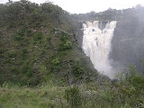
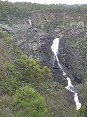
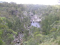
that includes several rare or threatened plants and animals. There are at least 14 waterfalls in the park.
and these valleys were the tribal lands of the Dangaddi aboriginal
people, whose descendants are now concentrated in the lower Macleay River
. Some marked trees have been found and a limestone cave shelter has been excavated near Kunderang Brook.
In 1818 explorer John Oxley
and his party tried to descend the Apsley valley, but steep gorges blocked the way until they proceeded around the head of the Apsley Falls
. After Oxley passed through the cedar-getters were the first white people to penetrate these remote gorges and valleys in search of Australian red cedar (Toona ciliata
) which was floated down-river to Kempsey
.
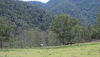
 There have been cattle grazing through the Macleay River
Gorges, called 'The Falls', since the 1840s, with mustering points (yards and huts) occurring at Top Creek, (Sunderlands) Middle Yards, Kunderang, Left Hand, Oven Camp, Youdales Hut, Green Gully, Yarrowitch River and Front Tableland. The recently restored Middle Yards Hut was once part of the 32,000-hectare East Kunderang cattle station
on the Macleay River.
.jpg) In the late 19th century several gold
In the late 19th century several gold
and antimony
mines were established around the rim of the gorges, at places such as Halls Peak and Hillgrove, as well as two ambitious hydro-electric schemes to power them, the remains of which can be seen today along the Styx River
and at Gara Gorge.
In 1976 the Apsley Macleay Gorges were identified as being of true wilderness
quality. At that stage the public protection offered to the area was limited to two small reserves in the south, and a few local council run recreation areas at popular sites such as Wollomombi Falls
, Dangars and Apsley Falls
. With future land-use undecided, the NSW Electricity Commission began surveying the Apsley Valley for a hydro-electric scheme in the late 1970s. The Apsley Gorge National Park of 6,718 hectares was gazetted followed by the 3,456 hectare Yarrowitch Gorge National Park soon after.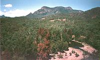 During late 1981 the track to the Apsley River
at Riverside was improved and Elcom installed a river gauging station. The project was shelved following a land use study recommending a national park
be established. In 1986 the park was gazetted to foster nature conservation, cultural heritage and tourism on the Northern Tablelands. In 1989 East Kunderang Station of 30,400 hectares passed to the National Parks and Wildlife Service (NPWS) and was proclaimed the Oxley Wild Rivers National Park.
In 1994 Oxley Wild Rivers National Park was inscribed on the Register of World Heritage sites, as part of the Central Eastern Rainforest Reserves of Australia (CERRA). Later 1,850 ha of Winterbourne State Forest, also known at the Big Lease, was added to the wilderness. The remaining 1,560 ha of Winterbourne and 1,075 ha of Enmore State Forests are to be added to the National Park. Further inclusions include Green Gully headwaters and 1,439 ha of leasehold land in the lower Chandlers River gorge.
The Macleay Gorges Wilderness Area was declared in 1996 and extended in 1997. It covers over 50,000 ha., mainly in the central part of the Park.
In December 2009 a lightning
strike started a bushfire in the Youdales Hut area. The hut was unaffected, but 1,500 hectares of inaccessible steep country was burnt out before it was brought under control. Another lightning strike started a large bushfire in the Reedy Creek region of the park. This fire has burnt out over 8,000 hectares of rough country.
, Tia
Falls and Dangars Falls as well as numerous cascades. The waterfalls in the park are at their best after rains and the main ones are accessible by car.
 The formation of the area began with muddy sediments under ancient oceans that were changed by heat and pressure into hard rocks, then uplifted by movements of the continental plate and volcanic eruptions. This resulted in the formation of the Great Dividing Range
, an undulating plateau
that sloped gently to the west and fell away steeply to the east.
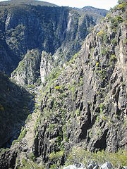
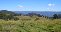
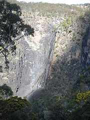
Erosion by wind, rain, storms and ice over millions of years carved out the plateaus of the Northern Tablelands, and rivers and streams gradually cut back the eastern edge of the tableland creating deep gorges that eventually formed one continuous escarpment. The jagged scarp is slowly retreating west and this movement can be seen today in the erosion of steep cliffs at places like Wollomombi, Dangars and Apsley Gorges.
The rare plants found include: Grevillea
obtusiflora, Acacia
blakei (subsp. diphylla) (Wollomombi or gorge wattle) and Acacia ingramii which grows at Dangars Gorge. Some Australian red cedar trees may also be seen in the more remote locations. Threatened flora of the area includes the Wedge-leaved Guinea flower (Hibbertia
hermanniifolia), Grevillea beadleana and Hakea
fraseri (Gorge Hakea). Hillgrove spotted gum (Eucalyptus michaeliana
) may be seen south of Hillgrove and in the Big Lease, north-east of Walcha. The beautiful Caladenia
orchid has been spotted at Long Point.
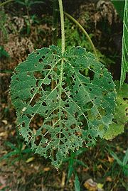
Dry rainforests in the OWRNP contain at least 187 plant species and they are visible as dense, dark green patches of brush box (Lophostemon confertus
), favouring hollows where there is shelter from wind and sun. The adaptable Bird's Nest Fern
(Asplenium australasicum
) grows in a variety of sites as an epiphyte
on large trees, independently growing on the forest floor or attached to rocks. Other plants that could be found in or around dry rainforests include: Native Rosella (Hibiscus heterophyllus
), gorge mock-olive (Notelaea
microcarpa), Brachychiton
discolor (lacebark), Moreton Bay fig (Ficus macrophylla), native olive (Olea paniculata
), red kamala (Mallotus
philippensis), scentless rosewood (Synoum glandulosum) and shatterwood (Backhousia
sciadophora).
The open forest and woodlands are dominated by various trees. The main species are: Angophora floribunda
(rough-barked apple), Eucalyptus
retinens (Hillgrove box), Eucalyptus andrewsii (New England blackbutt), Eucalyptus caliginosa
(broadleaved New England stringybark), Eucalyptus laevopinea (silvertop stringybark), Eucalyptus melliodora
(yellow box) and wild cherry. Eucalyptus tereticornis
(forest red gum) identified by the bark on its trunk which sheds to expose white, grey or bluish patches may also be seen, too. Epiphytic orchids may be observed growing in some of these trees, as well.
 The hazardous stinging tree (Dendrocnide excelsa
) is found in various locations throughout the park. This is a dangerous plant and physical contact with it should be avoided. The stems and leaves are coated with fine hairs which when imbedded in the skin cause severe pain and irritation for prolonged periods. Smilax australis
(lawyer vine or wait-a-while
) is another plant to be avoided as it has prickly climbing stems that are up to eight metres long and will catch in clothing or the skin.
The under storey is often sparse except for occasional Acacia
(wattles), Bursaria spinosa
(blackthorn), Xanthorrhoea
(grass trees) and The cassinia, geebung (Persoonia spp.), Pomaderris
lanigera (woolly pomaderris), Jacksonia scoparia
(dogwood) and Prostanthera
(mint bush) are the most common species in the area.
Because the conditions are extreme on the cliffs, quite a number of rare and uncommon shrubs are found there. These include: broadleaf hopbush (Dodonaea
rhombifolia), Dodonaea serratifolia, Grevillea beadleana, Grevillea obtustiflora, Hakea fraseri (gorge hakea), climbing fig, orchids and Westringia
sp. Bertya
ingramii (Narrow-leaved bertya) is an endangered species of shrub that is found in two locations, growing among rocks or in thin soils close to cliff-edges in dry woodland with she-oaks, wattles and tea-trees.
 for the Brush-tailed Rock-wallaby
(Petrogale pencillata), with the largest confirmed population in the Green Gully area of Yarrowitch.
Other species found in the park include bandicoots, bat
s, koala
s, wombat
s and numerous small ground mammals. Quolls, common brushtail possum
s, sugar glider
s, platypus
, echidna
s, wedge-tailed eagle
s, peregrine falcon
s and dingo
es may also be seen.
Over 173 bird species have been recorded in Oxley Wild Rivers National Park.
There have been 38 reptile and 19 amphibian species recorded in Oxley Wild Rivers National Park. Skink
s, goanna
s, tortoise
s, lizard
s, snake
s, frog
s and fish occur in the park, particularly on the river flats. A number of fish species have been recorded. Notable, is the speckled longfin eel
(Anguilla reinhardtii), which breeds in the ocean with the juveniles eventually returning to the Apsley–Macleay River system.
Twelve species are listed as threatened under the Threatened Species Conservation Act 1995 are found in the wilderness area consisting of: five mammals (Brush-tailed Phascogale, Brush-tailed Rock Wallaby (Petrogale penicillata), koala, Squirrel Glider
and Tiger Quoll
); four birds Glossy Black Cockatoo (Calyptorhynchus lathami), Greater Sooty Owl
(Tyto tenebricosa), Superb Fruit-dove
and Turquoise Parrot; one reptile Morelia spilota variegata (Carpet Python); and two frogs (Litoria piperata and Litoria subglandulosa). The National Park is home to the Macleay River tortoise, a recently discovered species, and the rare mammal, the Hastings River Mouse
(Pseudomys oralis), considered to be in imminent danger of extinction.
, east of Armidale and Oxley Highway
, east of Walcha
. All roads to visitor facilities are suitable for conventional cars except the 4WD tracks to Riverside, Youdales Hut and East Kunderang. A permit and key is required to gain vehicle access to these three sites.
There are several visitor entry points where visitors may enter with a 2WD car and camp overnight:
4WD vehicles are permitted to access Riverside, Youdales Hut and East Kunderang Homestead
where a permit and key are required. Riverside and Youdales Hut require a low range 4WD vehicle and trailers are not permitted.
fertilis), lantana (Lantana camara
), prickly pear (Opuntia
), blue heliotrope and blackberry
. Lantana was widely distributed in warmer lower areas of the park and also invaded rainforest thickets, where it has affected World Heritage values. Burrs of the Xanthium spp. are found on river flats, banks and associated tributaries.
Blackberry, giant Parramatta grass, Lantana and sweet briar (Rosa rubiginosa) being controlled using herbicide
. Spraying results have been encouraging but follow-up spraying is imperative to ensure long-term effectiveness. The release of the cactus moth Cactoblastis cactorum
within the park has facilitated the biological control of prickly pear.
 Wild dogs occur in the park and include dingoes, hybrids with domestic dogs. The National Parks and Wildlife Service give assistance to nearby landowners with respect to the control of these canine species. Wild dogs are controlled using a combination of methods, including baiting, aerial shooting and cooperative fencing with neighbours.
Feral pigs have a large impact on the park and cause ground disturbance that encourages soil erosion and weed invasion. Pigs are trapped, poisoned and are also controlled with ground and aerial shooting.
Feral goats are confined to the upper Chandler, Styx, Oaky, and Apsley rivers. They compete with the threatened brush-tailed rock-wallabies for food and shelter. The goats are controlled using ground and aerial shooting.
Over 100 head of feral horses (brumbies
) have been passively trapped in the Apsley catchment then re-homed.
New South Wales
New South Wales is a state of :Australia, located in the east of the country. It is bordered by Queensland, Victoria and South Australia to the north, south and west respectively. To the east, the state is bordered by the Tasman Sea, which forms part of the Pacific Ocean. New South Wales...
, Australia
Australia
Australia , officially the Commonwealth of Australia, is a country in the Southern Hemisphere comprising the mainland of the Australian continent, the island of Tasmania, and numerous smaller islands in the Indian and Pacific Oceans. It is the world's sixth-largest country by total area...
, 445 kilometres north of Sydney and is named in memory of the Australian explorer John Oxley
John Oxley
John Joseph William Molesworth Oxley was an explorer and surveyor of Australia in the early period of English colonisation.October 1802 he was engaged in coastal survey work including an expedition to Western Port in 1804-05...
, who passed through the area in 1818. The park covers 145,000 ha, being one of the largest national parks in NSW.
The Park is part of the Hastings-Macleay Group of the World Heritage Site
World Heritage Site
A UNESCO World Heritage Site is a place that is listed by the UNESCO as of special cultural or physical significance...
Gondwana Rainforests of Australia inscribed in 1986 and added to the Australian National Heritage List
Australian National Heritage List
The Australian National Heritage List is a list of places deemed to be of outstanding heritage significance to Australia. The list includes natural, historic and indigenous places...
in 2007.
The Oxley Wild Rivers National Park (OWRNP) was World Heritage listed in recognition of the extensive dry rainforest
Rainforest
Rainforests are forests characterized by high rainfall, with definitions based on a minimum normal annual rainfall of 1750-2000 mm...
that occurs within the park, and the associated rich biodiversity
Biodiversity
Biodiversity is the degree of variation of life forms within a given ecosystem, biome, or an entire planet. Biodiversity is a measure of the health of ecosystems. Biodiversity is in part a function of climate. In terrestrial habitats, tropical regions are typically rich whereas polar regions...
that includes several rare or threatened plants and animals. There are at least 14 waterfalls in the park.
History
For thousands of years, the Northern TablelandsNorthern Tablelands, New South Wales
The Northern Tablelands, also known as the New England Tableland, is a plateau and a region of the Great Dividing Range in northern New South Wales, Australia. It includes the New England Range, the narrow highlands area of the New England region, stretching from the Moonbi Range in the south to...
and these valleys were the tribal lands of the Dangaddi aboriginal
Australian Aborigines
Australian Aborigines , also called Aboriginal Australians, from the latin ab originem , are people who are indigenous to most of the Australian continentthat is, to mainland Australia and the island of Tasmania...
people, whose descendants are now concentrated in the lower Macleay River
Macleay River
The Macleay River is a major river on the Mid North Coast , Australia.The headwaters of the Macleay River rise as the Gara River on the eastern side of the Northern Tablelands near Armidale and Walcha, New South Wales. From here the Chandler River, Styx River and Apsley Rivers are important...
. Some marked trees have been found and a limestone cave shelter has been excavated near Kunderang Brook.
In 1818 explorer John Oxley
John Oxley
John Joseph William Molesworth Oxley was an explorer and surveyor of Australia in the early period of English colonisation.October 1802 he was engaged in coastal survey work including an expedition to Western Port in 1804-05...
and his party tried to descend the Apsley valley, but steep gorges blocked the way until they proceeded around the head of the Apsley Falls
Apsley Falls
The Apsley Falls are two waterfalls on the Apsley River on the Northern Tablelands, New South Wales, Australia. The falls are located about east of Walcha, and 1 kilometre off the Oxley Highway in a deep gorge, that is part of the Oxley Wild Rivers National Park...
. After Oxley passed through the cedar-getters were the first white people to penetrate these remote gorges and valleys in search of Australian red cedar (Toona ciliata
Toona ciliata
Australian Red Cedar , Toona ciliata is a forest tree in the family Meliaceae which grows throughout southern Asia from Afghanistan to Papua New Guinea and Australia. In Australia its natural habitat is now extensively cleared subtropical rainforests of New South Wales and Queensland...
) which was floated down-river to Kempsey
Kempsey, New South Wales
Kempsey is a town in the Mid North Coast region of New South Wales, Australia and is the council seat for Kempsey Shire. It is located 15 kilometres inland from the coast of the Pacific Ocean where the Pacific Highway and the North Coast railway line cross the Macleay River...
.
Macleay River
The Macleay River is a major river on the Mid North Coast , Australia.The headwaters of the Macleay River rise as the Gara River on the eastern side of the Northern Tablelands near Armidale and Walcha, New South Wales. From here the Chandler River, Styx River and Apsley Rivers are important...
Gorges, called 'The Falls', since the 1840s, with mustering points (yards and huts) occurring at Top Creek, (Sunderlands) Middle Yards, Kunderang, Left Hand, Oven Camp, Youdales Hut, Green Gully, Yarrowitch River and Front Tableland. The recently restored Middle Yards Hut was once part of the 32,000-hectare East Kunderang cattle station
Cattle station
Cattle station is an Australian term for a large farm , whose main activity is the rearing of cattle. In Australia, the owner of a cattle station is called a grazier...
on the Macleay River.
Gold
Gold is a chemical element with the symbol Au and an atomic number of 79. Gold is a dense, soft, shiny, malleable and ductile metal. Pure gold has a bright yellow color and luster traditionally considered attractive, which it maintains without oxidizing in air or water. Chemically, gold is a...
and antimony
Antimony
Antimony is a toxic chemical element with the symbol Sb and an atomic number of 51. A lustrous grey metalloid, it is found in nature mainly as the sulfide mineral stibnite...
mines were established around the rim of the gorges, at places such as Halls Peak and Hillgrove, as well as two ambitious hydro-electric schemes to power them, the remains of which can be seen today along the Styx River
Styx River (New South Wales)
The Styx River is a river in New South Wales, Australia.The Styx River rises in the Snowy Range, a spur of the Great Dividing Range, which forms part of the eastern escarpment of the Northern Tablelands. It starts near the village of Ebor....
and at Gara Gorge.
In 1976 the Apsley Macleay Gorges were identified as being of true wilderness
Wilderness
Wilderness or wildland is a natural environment on Earth that has not been significantly modified by human activity. It may also be defined as: "The most intact, undisturbed wild natural areas left on our planet—those last truly wild places that humans do not control and have not developed with...
quality. At that stage the public protection offered to the area was limited to two small reserves in the south, and a few local council run recreation areas at popular sites such as Wollomombi Falls
Wollomombi Falls
Wollomombi Falls , from an Aboriginal word, are located in the Oxley Wild Rivers National Park, 40 km due east of Armidale, New South Wales and 1 km off the Waterfall Way.At one time they were believed to be the tallest in Australia...
, Dangars and Apsley Falls
Apsley Falls
The Apsley Falls are two waterfalls on the Apsley River on the Northern Tablelands, New South Wales, Australia. The falls are located about east of Walcha, and 1 kilometre off the Oxley Highway in a deep gorge, that is part of the Oxley Wild Rivers National Park...
. With future land-use undecided, the NSW Electricity Commission began surveying the Apsley Valley for a hydro-electric scheme in the late 1970s. The Apsley Gorge National Park of 6,718 hectares was gazetted followed by the 3,456 hectare Yarrowitch Gorge National Park soon after.
Apsley River (New South Wales)
The Apsley River is a river on the Northern Tablelands of New South Wales, Australia. The headwaters of the river rise in high country about 11 kilometres west of Tia and approximately 29 km south of Walcha, New South Wales.- Geography :...
at Riverside was improved and Elcom installed a river gauging station. The project was shelved following a land use study recommending a national park
National park
A national park is a reserve of natural, semi-natural, or developed land that a sovereign state declares or owns. Although individual nations designate their own national parks differently A national park is a reserve of natural, semi-natural, or developed land that a sovereign state declares or...
be established. In 1986 the park was gazetted to foster nature conservation, cultural heritage and tourism on the Northern Tablelands. In 1989 East Kunderang Station of 30,400 hectares passed to the National Parks and Wildlife Service (NPWS) and was proclaimed the Oxley Wild Rivers National Park.
In 1994 Oxley Wild Rivers National Park was inscribed on the Register of World Heritage sites, as part of the Central Eastern Rainforest Reserves of Australia (CERRA). Later 1,850 ha of Winterbourne State Forest, also known at the Big Lease, was added to the wilderness. The remaining 1,560 ha of Winterbourne and 1,075 ha of Enmore State Forests are to be added to the National Park. Further inclusions include Green Gully headwaters and 1,439 ha of leasehold land in the lower Chandlers River gorge.
The Macleay Gorges Wilderness Area was declared in 1996 and extended in 1997. It covers over 50,000 ha., mainly in the central part of the Park.
In December 2009 a lightning
Lightning
Lightning is an atmospheric electrostatic discharge accompanied by thunder, which typically occurs during thunderstorms, and sometimes during volcanic eruptions or dust storms...
strike started a bushfire in the Youdales Hut area. The hut was unaffected, but 1,500 hectares of inaccessible steep country was burnt out before it was brought under control. Another lightning strike started a large bushfire in the Reedy Creek region of the park. This fire has burnt out over 8,000 hectares of rough country.
Geography
The Oxley Wild Rivers National Park lies along the Great Escarpment between the Northern Tablelands, and the east coast and has dramatic gorges and waterfalls, extensive wilderness and dry rainforest. The main rivers in the National Park are the: Apsley River, Macleay River, Chandler River, Tia River, Styx River, Gara River, Yarrowitch River, Oaky River and the Kunderang Brook. There are a number of waterfalls situated throughout the park including: Wollomombi, Apsley FallsApsley Falls
The Apsley Falls are two waterfalls on the Apsley River on the Northern Tablelands, New South Wales, Australia. The falls are located about east of Walcha, and 1 kilometre off the Oxley Highway in a deep gorge, that is part of the Oxley Wild Rivers National Park...
, Tia
Tia, New South Wales
Tia, is a settlement and parish located approximately 30 kilometres east of Walcha, on the Northern Tablelands region of New South Wales, Australia....
Falls and Dangars Falls as well as numerous cascades. The waterfalls in the park are at their best after rains and the main ones are accessible by car.
Geology
Great Dividing Range
The Great Dividing Range, or the Eastern Highlands, is Australia's most substantial mountain range and the third longest in the world. The range stretches more than 3,500 km from Dauan Island off the northeastern tip of Queensland, running the entire length of the eastern coastline through...
, an undulating plateau
Plateau
In geology and earth science, a plateau , also called a high plain or tableland, is an area of highland, usually consisting of relatively flat terrain. A highly eroded plateau is called a dissected plateau...
that sloped gently to the west and fell away steeply to the east.
Erosion by wind, rain, storms and ice over millions of years carved out the plateaus of the Northern Tablelands, and rivers and streams gradually cut back the eastern edge of the tableland creating deep gorges that eventually formed one continuous escarpment. The jagged scarp is slowly retreating west and this movement can be seen today in the erosion of steep cliffs at places like Wollomombi, Dangars and Apsley Gorges.
Flora
The Apsley Macleay Gorges are a converging point for moister eastern coastal and dry western floras, and some 950 native plant species have been identified, of which 36 are rare or threatened.The rare plants found include: Grevillea
Grevillea
Grevillea is a diverse genus of about 360 species of evergreen flowering plants in the protea family Proteaceae, native to Australia, New Guinea, New Caledonia, and Sulawesi. It was named in honour of Charles Francis Greville. The species range from prostrate shrubs less than 0.5 m tall to trees...
obtusiflora, Acacia
Acacia
Acacia is a genus of shrubs and trees belonging to the subfamily Mimosoideae of the family Fabaceae, first described in Africa by the Swedish botanist Carl Linnaeus in 1773. Many non-Australian species tend to be thorny, whereas the majority of Australian acacias are not...
blakei (subsp. diphylla) (Wollomombi or gorge wattle) and Acacia ingramii which grows at Dangars Gorge. Some Australian red cedar trees may also be seen in the more remote locations. Threatened flora of the area includes the Wedge-leaved Guinea flower (Hibbertia
Hibbertia
Hibbertia, or Guinea flower, is a genus of trees, shrubs, trailing shrubs and climbers of the family Dilleniaceae. The five-petalled flowers of all species are varying shades of yellow, with the exception of H. stellaris, H. miniata and H. selkii, a recently named species from the Stirling...
hermanniifolia), Grevillea beadleana and Hakea
Hakea
Hakea is a genus of 149 species of shrubs and small trees in the Proteaceae, native to Australia. They are found throughout the country, with the highest species diversity being found in the south west of Western Australia....
fraseri (Gorge Hakea). Hillgrove spotted gum (Eucalyptus michaeliana
Eucalyptus michaeliana
Eucalyptus michaeliana, commonly known as Hillgrove spotted gum, is a tree that grows to about 30 metres high and has a distinctive mottled, greenish trunk with peeling yellow-brown bark . These trees may be seen growing along the Long Point Road south of Hillgrove...
) may be seen south of Hillgrove and in the Big Lease, north-east of Walcha. The beautiful Caladenia
Caladenia
The genus Caladenia belongs to the subfamily Orchidoideae of the orchid family . The abbreviation Calda. is often used in trade journals to indicate the genus....
orchid has been spotted at Long Point.
Dry rainforests in the OWRNP contain at least 187 plant species and they are visible as dense, dark green patches of brush box (Lophostemon confertus
Lophostemon confertus
The Brush Box, Lophostemon confertus, is a tree native to Australia, though it can be found in the United States and elsewhere. Quite frequently, it has been planted as a street tree, due to its hearty nature, its disease and pest resilience, high tolerance for smog, drought and poor drainage, as...
), favouring hollows where there is shelter from wind and sun. The adaptable Bird's Nest Fern
Bird's Nest Fern
Bird's-nest fern is a common name applied to several related species of ferns in the genus Asplenium. They grow in a tight, nest-like clump with a lingulate leaf rosette and are usually epiphytic, growing in trees...
(Asplenium australasicum
Asplenium australasicum
Asplenium australasicum is a species of plant in the Aspleniaceae family found in eastern Australia.-Taxonomy:Asplenium australasicum was originally described by English botanist John Smith in 1857 as Neottopteris australasica. He had reclassified the already known A. nidus in its own genus...
) grows in a variety of sites as an epiphyte
Epiphyte
An epiphyte is a plant that grows upon another plant non-parasitically or sometimes upon some other object , derives its moisture and nutrients from the air and rain and sometimes from debris accumulating around it, and is found in the temperate zone and in the...
on large trees, independently growing on the forest floor or attached to rocks. Other plants that could be found in or around dry rainforests include: Native Rosella (Hibiscus heterophyllus
Hibiscus heterophyllus
Hibiscus heterophyllus, also known as Native Rosella, is a species of hibiscus that is endemic to New South Wales and Queensland in Australia....
), gorge mock-olive (Notelaea
Notelaea
Notelaea is a genus of Australian plants of the family Oleaceae.Species include:*Notelaea ipsviciensis W.K.Harris*Notelaea johnsonii P.S.Green*Notelaea ligustrina Vent.*Notelaea linearis Benth.*Notelaea lloydii Guymer...
microcarpa), Brachychiton
Brachychiton
Brachychiton is a genus of 31 species of trees and large shrubs, native to Australia , and New Guinea . Fossils from New South Wales and New Zealand are estimated to be 50 million years old, corresponding to the Tertiary.They grow to 4 – 30m tall, and some are dry-season deciduous...
discolor (lacebark), Moreton Bay fig (Ficus macrophylla), native olive (Olea paniculata
Olea paniculata
Olea paniculata, commonly known as the Native Olive, is a plant of the genus Olea and a relative of the olive. It is found from Yunnan in southwestern China and Pakistan across southern Asia to Australia and New Caledonia, Vanuatu and Lord Howe Island in the Pacific Ocean.-Taxonomy:One of many...
), red kamala (Mallotus
Mallotus (plant)
Mallotus is a genus of the spurge family Euphorbiaceae. 2 species are found in tropical Africa and Madagascar. About 140 species are found in East and Southeast Asia and from Indomalaysia to New Caledonia and Fiji, northern and eastern Australia...
philippensis), scentless rosewood (Synoum glandulosum) and shatterwood (Backhousia
Backhousia
Backhousia is a small genus of five species of flowering plants in the family Myrtaceae, native to the rainforests of eastern Australia. They are aromatic shrubs or trees growing to 5-25 m tall, with evergreen leaves 3-12 cm long and 1-6 cm broad, arranged opposite on the shoots.Species...
sciadophora).
The open forest and woodlands are dominated by various trees. The main species are: Angophora floribunda
Angophora floribunda
Angophora floribunda is a common woodland and forest tree of Eastern Australia and is known by a variety of names including Rough-barked apple, Apple box, Rusty gum, and Boondah....
(rough-barked apple), Eucalyptus
Eucalyptus
Eucalyptus is a diverse genus of flowering trees in the myrtle family, Myrtaceae. Members of the genus dominate the tree flora of Australia...
retinens (Hillgrove box), Eucalyptus andrewsii (New England blackbutt), Eucalyptus caliginosa
Eucalyptus caliginosa
Eucalyptus caliginosa, Broad-leaved Stringybark, New England Stringybark, is a medium sized tree with grey to red-brown, fibrous, stringy, fissured longitudinally, bark with red-brown underlayers to small branches...
(broadleaved New England stringybark), Eucalyptus laevopinea (silvertop stringybark), Eucalyptus melliodora
Eucalyptus melliodora
Eucalyptus melliodora, commonly known as Yellow Box, is a medium sized to occasionally tall eucalypt. The bark is variable ranging from smooth with an irregular, short stocking, to covering most of the trunk, fibrous, dense or loosely held, grey, yellow or red-brown, occasionally very coarse,...
(yellow box) and wild cherry. Eucalyptus tereticornis
Eucalyptus tereticornis
Eucalyptus tereticornis is a species of tree native to eastern Australia.It has a great many common names, of which Forest Red Gum is perhaps the most widely known...
(forest red gum) identified by the bark on its trunk which sheds to expose white, grey or bluish patches may also be seen, too. Epiphytic orchids may be observed growing in some of these trees, as well.
Dendrocnide excelsa
Dendrocnide excelsa, the giant stinging tree is a rainforest tree of eastern Australia. It occurs from Tathra, New South Wales to Imbil in south eastern Queensland, and is very common at Dorrigo National Park and other rainforest walks in eastern Australia...
) is found in various locations throughout the park. This is a dangerous plant and physical contact with it should be avoided. The stems and leaves are coated with fine hairs which when imbedded in the skin cause severe pain and irritation for prolonged periods. Smilax australis
Smilax australis
Smilax australis is a vine in the family Smilacaceae, endemic to Australia. It has prickly climbing stems that are up to 8 metres long with coiled tendrils that are up to 20 cm long...
(lawyer vine or wait-a-while
Wait-a-while
Wait-a-while may refer to:*Acacia cuspidifolia, a plant that occurs in Western Australia*Smilax australis, a vine that occurs in eastern Australia and the Northern Territory*Calamus australis, a climbing vine-like palm...
) is another plant to be avoided as it has prickly climbing stems that are up to eight metres long and will catch in clothing or the skin.
The under storey is often sparse except for occasional Acacia
Acacia
Acacia is a genus of shrubs and trees belonging to the subfamily Mimosoideae of the family Fabaceae, first described in Africa by the Swedish botanist Carl Linnaeus in 1773. Many non-Australian species tend to be thorny, whereas the majority of Australian acacias are not...
(wattles), Bursaria spinosa
Bursaria spinosa
Bursaria spinosa is a small tree or shrub in the family Pittosporaceae. The species occurs in mainly in the eastern and southern half of Australia and not in Western Australia and the Northern Territory. Reaching 10 m high, it bears fragrant white flowers at any time of year but particularly summer...
(blackthorn), Xanthorrhoea
Xanthorrhoea
Xanthorrhoea is a genus of flowering plants native to Australia and a member of family Xanthorrhoeaceae, being the only member of subfamily Xanthorrhoeoideae. The Xanthorrhoeaceae are monocots, part of order Asparagales. There are 28 species and five subspecies of Xanthorrhoea.-Description:All are...
(grass trees) and The cassinia, geebung (Persoonia spp.), Pomaderris
Pomaderris
Pomaderris is a genus of 70 species of shrub to small tree in the buckthorn family Rhamnaceae. 65 of the species are native to Australia and the other five are from New Zealand. There is some overlap....
lanigera (woolly pomaderris), Jacksonia scoparia
Jacksonia scoparia
Jacksonia scoparia, commonly known as dogwood , is a native species of a pea-flowered, greyish leafless broom-like shrub or small tree that occurs in the south east of Queensland, Australia and eastern New South Wales...
(dogwood) and Prostanthera
Prostanthera
Prostanthera, commonly known as Mintbush, is a genus of plants of the family Lamiaceae. There are about 90 species within the genus, all of which are endemic to Australia. The word is derived from the Greek, which refers to an appendage...
(mint bush) are the most common species in the area.
Because the conditions are extreme on the cliffs, quite a number of rare and uncommon shrubs are found there. These include: broadleaf hopbush (Dodonaea
Dodonaea
Dodonaea is a genus of about 70 species of flowering plants in the soapberry family, Sapindaceae, with a cosmopolitan distribution in tropical, subtropical and warm temperate regions of Africa, the Americas, southern Asia and Australasia. By far the highest species diversity is in Australia...
rhombifolia), Dodonaea serratifolia, Grevillea beadleana, Grevillea obtustiflora, Hakea fraseri (gorge hakea), climbing fig, orchids and Westringia
Westringia
Westringia is a genus of Australian shrubs. As with other members of the mint family their upper petal is divided into two lobes. There are four stamens - the upper two are fertile while the lower two are reduced to staminodes...
sp. Bertya
Bertya
Bertya is a genus of plants in the family Euphorbiaceae....
ingramii (Narrow-leaved bertya) is an endangered species of shrub that is found in two locations, growing among rocks or in thin soils close to cliff-edges in dry woodland with she-oaks, wattles and tea-trees.
Fauna
The park is rich in fauna, with over 350 species recorded, including 55 mammals. Oxley Wild Rivers National Park is a major refugeBrush-tailed Rock-wallaby
The Brush-tailed Rock-wallaby or Small-eared Rock-wallaby is a kind of wallaby, one of several rock-wallabies in the genus Petrogale. It inhabits rock piles and cliff lines along the Great Dividing Range from about 100 km north-west of Brisbane to northern Victoria, in vegetation ranging from...
(Petrogale pencillata), with the largest confirmed population in the Green Gully area of Yarrowitch.
Other species found in the park include bandicoots, bat
Bat
Bats are mammals of the order Chiroptera "hand" and pteron "wing") whose forelimbs form webbed wings, making them the only mammals naturally capable of true and sustained flight. By contrast, other mammals said to fly, such as flying squirrels, gliding possums, and colugos, glide rather than fly,...
s, koala
Koala
The koala is an arboreal herbivorous marsupial native to Australia, and the only extant representative of the family Phascolarctidae....
s, wombat
Wombat
Wombats are Australian marsupials; they are short-legged, muscular quadrupeds, approximately in length with a short, stubby tail. They are adaptable in their habitat tolerances, and are found in forested, mountainous, and heathland areas of south-eastern Australia, including Tasmania, as well as...
s and numerous small ground mammals. Quolls, common brushtail possum
Common Brushtail Possum
The Common Brushtail Possum is a nocturnal, semi-arboreal marsupial of the family Phalangeridae, it is native to Australia, and the largest of the possums.Like most possums, the Common Brushtail is nocturnal...
s, sugar glider
Sugar Glider
The sugar glider is a small gliding possum originating from the marsupial family.The sugar glider is native to eastern and northern mainland Australia and is also native to New Guinea and the Bismarck Archipelago.- Habitat :Sugar gliders can be found all throughout the northern and eastern parts of...
s, platypus
Platypus
The platypus is a semi-aquatic mammal endemic to eastern Australia, including Tasmania. Together with the four species of echidna, it is one of the five extant species of monotremes, the only mammals that lay eggs instead of giving birth to live young...
, echidna
Echidna
Echidnas , also known as spiny anteaters, belong to the family Tachyglossidae in the monotreme order of egg-laying mammals. There are four extant species, which, together with the platypus, are the only surviving members of that order and are the only extant mammals that lay eggs...
s, wedge-tailed eagle
Wedge-tailed Eagle
The Wedge-tailed Eagle , sometimes known as the Eaglehawk in its native range, is the largest bird of prey in Australia, but it is also found in southern New Guinea. It has long, fairly broad wings, fully feathered legs, and an unmistakable wedge-shaped tail...
s, peregrine falcon
Peregrine Falcon
The Peregrine Falcon , also known as the Peregrine, and historically as the Duck Hawk in North America, is a widespread bird of prey in the family Falconidae. A large, crow-sized falcon, it has a blue-gray back, barred white underparts, and a black head and "moustache"...
s and dingo
Dingo
The Australian Dingo or Warrigal is a free-roaming wild dog unique to the continent of Australia, mainly found in the outback. Its original ancestors are thought to have arrived with humans from southeast Asia thousands of years ago, when dogs were still relatively undomesticated and closer to...
es may also be seen.
Over 173 bird species have been recorded in Oxley Wild Rivers National Park.
There have been 38 reptile and 19 amphibian species recorded in Oxley Wild Rivers National Park. Skink
Skink
Skinks are lizards belonging to the family Scincidae. Together with several other lizard families, including Lacertidae , they comprise the superfamily or infraorder Scincomorpha...
s, goanna
Goanna
Goanna is the name used to refer to any number of Australian monitor lizards of the genus Varanus, as well as to certain species from Southeast Asia.There are around 30 species of goanna, 25 of which are found in Australia...
s, tortoise
Tortoise
Tortoises are a family of land-dwelling reptiles of the order of turtles . Like their marine cousins, the sea turtles, tortoises are shielded from predators by a shell. The top part of the shell is the carapace, the underside is the plastron, and the two are connected by the bridge. The tortoise...
s, lizard
Lizard
Lizards are a widespread group of squamate reptiles, with nearly 3800 species, ranging across all continents except Antarctica as well as most oceanic island chains...
s, snake
Snake
Snakes are elongate, legless, carnivorous reptiles of the suborder Serpentes that can be distinguished from legless lizards by their lack of eyelids and external ears. Like all squamates, snakes are ectothermic, amniote vertebrates covered in overlapping scales...
s, frog
Frog
Frogs are amphibians in the order Anura , formerly referred to as Salientia . Most frogs are characterized by a short body, webbed digits , protruding eyes and the absence of a tail...
s and fish occur in the park, particularly on the river flats. A number of fish species have been recorded. Notable, is the speckled longfin eel
Speckled longfin eel
The speckled longfin eel, Australian long-finned eel or marbled eel, Anguilla reinhardtii, is one of 15 species of eel in the family Anguillidae. It has a long snake-like cylindrical body with its dorsal, tail and anal fins joined to form one long fin. It usually has a brownish green or olive green...
(Anguilla reinhardtii), which breeds in the ocean with the juveniles eventually returning to the Apsley–Macleay River system.
Twelve species are listed as threatened under the Threatened Species Conservation Act 1995 are found in the wilderness area consisting of: five mammals (Brush-tailed Phascogale, Brush-tailed Rock Wallaby (Petrogale penicillata), koala, Squirrel Glider
Squirrel Glider
The Squirrel Glider is a nocturnal gliding possum, one of the wrist-winged gliders of the genus Petaurus.-Habitat:...
and Tiger Quoll
Tiger Quoll
The tiger quoll , also known as the spotted-tail quoll, the spotted quoll, the spotted-tailed dasyure or the tiger cat, is a carnivorous marsupial of the quoll genus Dasyurus native to Australia...
); four birds Glossy Black Cockatoo (Calyptorhynchus lathami), Greater Sooty Owl
Greater Sooty Owl
"Black owl" redirects here. For the comic-book superhero, see Black Owl.The Sooty Owl , also known as the Greater Sooty Owl, is a medium to large owl found in south-eastern Australia, Montane rainforests of New Guinea and have been seen on Flinders Island in the Bass Strait. They have a finely...
(Tyto tenebricosa), Superb Fruit-dove
Superb Fruit-Dove
The Superb Fruit Dove , also known as the Purple-crowned Fruit Dove , is a medium-sized , colourful fruit-dove in the family Columbidae....
and Turquoise Parrot; one reptile Morelia spilota variegata (Carpet Python); and two frogs (Litoria piperata and Litoria subglandulosa). The National Park is home to the Macleay River tortoise, a recently discovered species, and the rare mammal, the Hastings River Mouse
Hastings River Mouse
The Hastings River Mouse is a species of rodent in the family Muridae.It is found only in Australia.-Habitat:These rodents often prefer damp and moist environments, along drainage lines if necessary...
(Pseudomys oralis), considered to be in imminent danger of extinction.
Attractions
Car access to the park is mainly via the Waterfall WayWaterfall Way
The Waterfall Way is a road and State Highway 78 in New South Wales, Australia. It runs east-west from the Pacific Highway to the New England Highway at Armidale. The route passes through some of New South Wales' most scenic countryside and has become well known as New South Wales best and...
, east of Armidale and Oxley Highway
Oxley Highway
The Oxley Highway is a rural highway in New South Wales, Australia. It starts at Nevertire where it joins the Mitchell Highway. It links Warren, Gilgandra, Coonabarabran, Gunnedah, Carroll, Tamworth, Bendemeer, Walcha, Yarrowitch, Ellenborough, Long Flat, Wauchope and ends at Port Macquarie on the...
, east of Walcha
Walcha, New South Wales
Walcha is a parish and town at the south-eastern edge of the Northern Tablelands, New South Wales, Australia.The town serves as the seat of Walcha Shire. Walcha is located 425 kilometres by road from Sydney at the intersection of the Oxley Highway and Thunderbolts Way...
. All roads to visitor facilities are suitable for conventional cars except the 4WD tracks to Riverside, Youdales Hut and East Kunderang. A permit and key is required to gain vehicle access to these three sites.
There are several visitor entry points where visitors may enter with a 2WD car and camp overnight:
- Apsley FallsApsley FallsThe Apsley Falls are two waterfalls on the Apsley River on the Northern Tablelands, New South Wales, Australia. The falls are located about east of Walcha, and 1 kilometre off the Oxley Highway in a deep gorge, that is part of the Oxley Wild Rivers National Park...
– 20 kilometres east of WalchaWalcha, New South WalesWalcha is a parish and town at the south-eastern edge of the Northern Tablelands, New South Wales, Australia.The town serves as the seat of Walcha Shire. Walcha is located 425 kilometres by road from Sydney at the intersection of the Oxley Highway and Thunderbolts Way...
, 1 km off the Oxley HighwayOxley HighwayThe Oxley Highway is a rural highway in New South Wales, Australia. It starts at Nevertire where it joins the Mitchell Highway. It links Warren, Gilgandra, Coonabarabran, Gunnedah, Carroll, Tamworth, Bendemeer, Walcha, Yarrowitch, Ellenborough, Long Flat, Wauchope and ends at Port Macquarie on the...
. Here the Northern Tablelands plateau drops precipitously into the rugged gorges carved out by the Aspley and upper Macleay RiverMacleay RiverThe Macleay River is a major river on the Mid North Coast , Australia.The headwaters of the Macleay River rise as the Gara River on the eastern side of the Northern Tablelands near Armidale and Walcha, New South Wales. From here the Chandler River, Styx River and Apsley Rivers are important...
s which meander through the Park. There is a 52 metre steel stairway leading to an observation deck (with disabled access) where there are great views of the deep gorge and the falls. There are two spectacular falls, with two walking tracks taking in the Gorge Rim Walk and the Oxley Walk, picnic facilities and camping area for overnight stays. On 28 December 2009 the steel footbridge leading to Gorge Rim Walk was washed away.
- TiaTia, New South WalesTia, is a settlement and parish located approximately 30 kilometres east of Walcha, on the Northern Tablelands region of New South Wales, Australia....
Falls – 38 kilometres east of Walcha, 6 km off the Oxley HighwayOxley HighwayThe Oxley Highway is a rural highway in New South Wales, Australia. It starts at Nevertire where it joins the Mitchell Highway. It links Warren, Gilgandra, Coonabarabran, Gunnedah, Carroll, Tamworth, Bendemeer, Walcha, Yarrowitch, Ellenborough, Long Flat, Wauchope and ends at Port Macquarie on the...
. The turnoff for this road is 19 kilometres past the Apsley FallsApsley FallsThe Apsley Falls are two waterfalls on the Apsley River on the Northern Tablelands, New South Wales, Australia. The falls are located about east of Walcha, and 1 kilometre off the Oxley Highway in a deep gorge, that is part of the Oxley Wild Rivers National Park...
turnoff (travelling from Walcha). There are spectacular falls, with two walking tracks taking in the Falls and Gorge Walk (1.5 kilometres return) and the Tiara Walk (5 kilometres return), picnic facilities and bush camp sites are available for overnight stays.
- Budds Mare campground is 44 kilometres east of Walcha via the Moona Plains Road. The route includes 8 km of unpaved roads, which is unsuitable for standard 2WD cars, because of washouts. Budds Mare is set in bushland and a short walk takes you to the lookout which has spectacular views over Gondwana dry rainforest in the Apsley River Gorge. Across the first gorge is the obvious feature of Paradise Rocks and to the north it is possible to see Round Mountain and Point Lookout. Heading to the right from the shelter shed is a track to a vantage point that overlooks Rusden Creek Gorge. There is a good eight kilometre walk from here down the ridge to the Riverside Visitor Area on the Apsley River, but it is only for well prepared bushwalkers with a sound knowledge of steep country. Return up the same track or follow the road from Riverside up to the top. The return routes are a demanding climb, suitable for fit, experienced bushwalkers only, carrying ample provisions. Alternatively, a 4WD vehicle pick-up may be arranged at Riverside. Facilities here include: Campsites, toilets, picnic tables, wood barbecues, a supply of firewood.
- Wollomombi FallsWollomombi FallsWollomombi Falls , from an Aboriginal word, are located in the Oxley Wild Rivers National Park, 40 km due east of Armidale, New South Wales and 1 km off the Waterfall Way.At one time they were believed to be the tallest in Australia...
- a spectacular gorge which houses two waterfalls, the Wollomombi Falls, one of Australia's highest and the Chandler Falls. Located 40 kilometres east of Armidale along the Waterfall Way. See rugged scenery, picnic, stroll along one of the gorge rim trails, or hike to the gorge riverbed. Facilities include drinking water, toilets, shelter shed & fireplace and bush camp sites are available for overnight stays.
- Halls Peak camping area is off Raspberry Road, east of Armidale. The very steep 4WD trail, suitable only for vehicles with a low range, continues on down to a good camping area on the Chandler River. The new facility consists of thirteen camping sites with pit fires, tables, barbecues and toilets. There are several mines in this area and the Halls Peak Mine may be seen from near the camping area.
- Dangars Gorge and Falls are 22 kilometres south-east of Armidale along the Dangersleigh Road and are home to the beautiful Dangars Falls, and the starting point for several great walks. McDirtys Walk - 6.9 km, 3 hours, medium difficulty. From the carpark at Dangars Gorge, cross the river and follow the track to the lookout above the falls (1.4 kilometres return), and Rock Wallaby Lookout (2.1 kilometres return). The track follows the gorge rim along a ridge to McDirtys Lookout (6.9 kilometres return). There are good places for picnics, camping and bushwalking. Salisbury Waters Walk - 14 km, 8 hours, difficult. This walk is an excellent introduction to gorge bushwalking, and can be undertaken in one strenuous or two leisurely days. From Dangars carpark cross the river (if the river is high do not attempt to cross), and follow the track past the turn off to McDirtys, heading out along the ridge as sign-posted to Sarum Hill Lookout (10.7 kilometres return), descending 500 metres to Salisbury Waters (14 kilometres return).
- Long Point campground - Access is via the historic gold mining town of Hillgrove. Follow the Waterfall Way 32 kilometres east of Armidale to the Hillgrove turnoff. Head south from Hillgrove for 17 kilometres along the gravel road. Located in a small forest clearing, this campground gives ready access to the easy 1.5 km Cassinia Walk, medium difficulty 6 km Chandler View Circuit Walk and the 33 km difficult Long Point to Wollomombi overnight bushwalk. For the latter walk a vehicle drop-off and pick-up and suitable equipment are needed. Basic track notes are available from the NPWS Armidale office. Long Point has two formal lookouts along the Chandler View Circuit walk and Cassinia Walk offering views over the Chandler and Macleay Gorges. Facilities include: carpark, shelter shed with fireplace, picnic tables with small wood barbecues, tank water, pit toilets, an information display and bush camping with firewood supplied.
4WD vehicles are permitted to access Riverside, Youdales Hut and East Kunderang Homestead
Homestead (buildings)
A homestead is either a single building, or collection of buildings grouped together on a large agricultural holding, such as a ranch, station or a large agricultural operation of some other designation.-See also:* Farm house* Homestead Act...
where a permit and key are required. Riverside and Youdales Hut require a low range 4WD vehicle and trailers are not permitted.
- Riverside Rest Area is on the banks of the Apsley River, 50 kilometres east of Walcha and is reached by the Moona Plains Road. The trail from Budds Mare Rest Area is a steep gravel track and a 4WD with low range is necessary. Trailers are not permitted. Fees apply, a locked gate key and permit are essential to use this trail with a vehicle. The Riverside Trail was opened in April 1997 to permit vehicle access to the Macleay Gorges area. The road down to the river shows the diversity of flora as you drop in elevation and visitors can experience groves of Native Hibiscus (Hibiscus heterophyllusHibiscus heterophyllusHibiscus heterophyllus, also known as Native Rosella, is a species of hibiscus that is endemic to New South Wales and Queensland in Australia....
) and get to see river bank terraces shaded with large, Fuzzy Box (Eucalyptus conicaEucalyptus conicaEucalyptus conica, known as the Fuzzy Box is a common eucalyptus tree of the slopes and plains of New South Wales and adjacent areas in Queensland. Occurring as far north as the Carnarvon Range....
). Bluff Rock (or The Terrace) walk - 1.5 km, one hour, medium difficulty, is reached by heading north-west from the visitor area, across a gully and up the hill to the management trail which leads to the top of the bluff rock, overlooking the river and across to Paradise Rocks. Activities: Swimming, hiking, fishing and photography. Facilities: 13 camp sites, toilets, picnic tables, electric/gas barbecues, wood barbecues, firewood supplied.
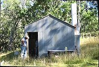
- Youdales Hut is a historic pioneering timber slab walled hut that was built in the 1930s on a small pastoral run established in the Kunderang Gorges. Alan Youdale is believed to have been guided here by an Aboriginal man, and he then settled here in circa 1939. This camping ground is approximately 96 km from Walcha and can be accessed via Kangaroo Flat Road, which leaves the Oxley Highway 55 kilometres from Walcha. The trail is narrow and steep and a 4WD with low range is necessary. Trailers are not permitted. Access is also possible via Carrai Road, Coachwood Road and the Racecourse Trail from Kempsey, or the Hastings Forest Way and Racecourse Trail from Port Macquarie. Visitor numbers are limited so bookings are essential. A permit and key is necessary to gain entry to this area and they may be obtained from Apsley Motors or the Park office, Walcha. The area caters for both picnickers and campers, with wood barbecues (wood provided), toilet and interpretation display at the hut. It's ideal for picnics, swimming and short walks.
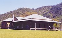
- East Kunderang Homestead is set on the banks of the Macleay River 112 kilometres east of Armidale via Wollomombi and the Kempsey Road. Access to the homestead is along steep gravel roads and a 4WD is required along with a permit. This historic homestead built in the 1890s, of solid cedar throughout, was once the centre of a grazing empire. It has now been carefully restored by the National Parks and Wildlife ServiceNational Parks and Wildlife Service (New South Wales)The National Parks and Wildlife Service is part of the Office of Environment and Heritage - the main government conservation agency in New South Wales, Australia....
to provide comfortable and modern accommodation. Edward's Fitzgerald’s grave is uphill from the rear of the homestead near a clump of gum trees along the fence line. Edward was drowned in 1900 while returning on horseback from the mail run. The homestead may be booked for up to ten people for a minimum of two nights. Marys View, a lookout situated on a bluff about 3 km south east of East Kunderang homestead, has perhaps the best view of any lookout of the Macleay Gorges. This lookout can be accessed as a day walk from East Kunderang. From here you have a 300 degree view almost from Point Lookout in New England National Park near Dorrigo back to Mummel Gulf National Park near Walcha. On a clear day you can see Mount Duval near Armidale, more than 70 km away. A 4WD vehicle is needed to access Marys View, from outside OWRNP, and it is at least a 7 hour return trip from either Walcha or Armidale and onto the Carrai tableland. There is no vehicle access from East Kunderang.
- The Bicentennial National TrailBicentennial National TrailThe Bicentennial National Trail , formerly known as the National Horse Trail is the longest marked multi-use trail in the world, stretching 5,330 kilometres from Cooktown, through New South Wales to Healesville, 60 km north-east of Melbourne...
for walking and horse riding passes from Cedar Creek on the edge of Werrikimbe National ParkWerrikimbe National ParkWerrikimbe National Park is in the catchment zone of the Upper Hastings River, New South Wales, Australia, about 486 km north of Sydney. This national park is about 80 km west of Wauchope and 90 km east of Walcha on the eastern escarpment of the Great Dividing Range...
past Youdales Hut via East Kunderang to Georges Junction on the Armidale to Kempsey road, which is a distance of some 75 kilometres through the National Park. The track is mostly unmarked but follows Kunderang Brook as it descends into the Macleay past East Kunderang Homestead in Oxley Wild Rivers National Park. The walk takes at least 5 days and all food and equipment has to be carried and there are numerous creek and river crossings, with some steep ascents and descents. This route generally takes at least 4 days to ride, and can be impassable after rain – check with Armidale or Walcha NPWS for details. Huts at Left Hand and Middle Yards are managed for their cultural heritage value, but are available for use while on the National Trail. The historic, remote Middle Yards Hut, located on Kunderang Brook deep within Oxley Wild Rivers National Park, has been restored to its original condition by the NPWS. A holding yard for horse trekkers was constructed here, along with a hitching rail, period furniture inside the hut, an outdoor barbecue and new water tank. Horses are not permitted at East Kunderang homestead.
- Gara Gorge is 18 kilometres south-east of Armidale along the Castledoyle Road off the Waterfall Way just east of Armidale. The remains of Australia's first public hydro-electric scheme can be viewed here. Gara Gorge is popular picnic area with tables, drinking water, toilets and gas barbecues. Well known for scenic bush strolls and the Blue Hole which is popular for swimming. The 5 km Threlfall Walk follows the route of the historic 1894 hydro-electric scheme, along old embankments and through ancient cuttings, to a lookout platform high above the river. Crombies Cave, the longest granite cave in Australia at 832 metres, can be found in the next small creek, Powers Creek, an easy walk to the south of the Blue Hole. As the creek flows under the fence from the surrounding grazing country, within 20 metres it begins its journey underground to come out 832 metres down stream. The cave can be accessed from here and negotiated for at least half its length. It contains very beautiful granite sculptures, gnammas and potholes, some big caverns and a small sandy beach near the lower exit. A climb down a small waterfall and a curving squeeze can be difficult for some to negotiate. The exits downstream can be difficult to find from the outside.
Weeds in the park
The most significant introduced species are Giant Parramatta grass (SporobolusSporobolus
Sporobolus is a genus of grasses in the family Poaceae. They are usually called dropseed grasses or sacaton grasses. They are typical prairie and savanna plants, and they occur in other types of open habitat in warmer climates....
fertilis), lantana (Lantana camara
Lantana camara
Lantana camara, also known as Spanish Flag or West Indian Lantana, is a species of flowering plant in the verbena family, Verbenaceae, that is native to the American tropics. It has been introduced into other parts of the world as an ornamental plant and is considered an invasive species in many...
), prickly pear (Opuntia
Opuntia
Opuntia, also known as nopales or paddle cactus , is a genus in the cactus family, Cactaceae.Currently, only prickly pears are included in this genus of about 200 species distributed throughout most of the Americas. Chollas are now separated into the genus Cylindropuntia, which some still consider...
), blue heliotrope and blackberry
Blackberry
The blackberry is an edible fruit produced by any of several species in the Rubus genus of the Rosaceae family. The fruit is not a true berry; botanically it is termed an aggregate fruit, composed of small drupelets. The plants typically have biennial canes and perennial roots. Blackberries and...
. Lantana was widely distributed in warmer lower areas of the park and also invaded rainforest thickets, where it has affected World Heritage values. Burrs of the Xanthium spp. are found on river flats, banks and associated tributaries.
Blackberry, giant Parramatta grass, Lantana and sweet briar (Rosa rubiginosa) being controlled using herbicide
Herbicide
Herbicides, also commonly known as weedkillers, are pesticides used to kill unwanted plants. Selective herbicides kill specific targets while leaving the desired crop relatively unharmed. Some of these act by interfering with the growth of the weed and are often synthetic "imitations" of plant...
. Spraying results have been encouraging but follow-up spraying is imperative to ensure long-term effectiveness. The release of the cactus moth Cactoblastis cactorum
Cactoblastis cactorum
Cactoblastis cactorum, commonly known as the Cactus Moth, South American Cactus Moth, or Nopal Moth, is native to Argentina, Paraguay, Uruguay, and southern Brazil. It is one of five species in the genus Cactoblastis that lives in South America...
within the park has facilitated the biological control of prickly pear.
Pest animals
Feral cats and foxes occur in moderate numbers and can impact on native fauna.Feral pigs have a large impact on the park and cause ground disturbance that encourages soil erosion and weed invasion. Pigs are trapped, poisoned and are also controlled with ground and aerial shooting.
Feral goats are confined to the upper Chandler, Styx, Oaky, and Apsley rivers. They compete with the threatened brush-tailed rock-wallabies for food and shelter. The goats are controlled using ground and aerial shooting.
Over 100 head of feral horses (brumbies
Brumby
A Brumby is a free-roaming feral horse in Australia. Although found in many areas around the country, the best-known brumbies are found in the Australian Alps region in south-eastern Australia. Today, most of them are found in the Northern Territory, with the second largest population in Queensland...
) have been passively trapped in the Apsley catchment then re-homed.
Adjoining national parks
- Carrai National ParkCarrai National ParkCarrai is a national park in New South Wales, Australia, 347 km north of Sydney....
- Cunnawarra National ParkCunnawarra National ParkCunnawarra is a national park in New South Wales, Australia, 80 km east of Armidale, 10 km off the Waterfall Way and 565 km north of Sydney. The 25 kilometre Styx River Forest Way runs from the Point Lookout Road through Cunnawarra National Park to the Kempsey Road...
- Werrikimbe National ParkWerrikimbe National ParkWerrikimbe National Park is in the catchment zone of the Upper Hastings River, New South Wales, Australia, about 486 km north of Sydney. This national park is about 80 km west of Wauchope and 90 km east of Walcha on the eastern escarpment of the Great Dividing Range...
- Willi Willi National ParkWilli Willi National ParkWilli Willi is a national park in New South Wales, Australia, 325 km northeast of Sydney. It is quite noticeable from nearby Port Macquarie as a tall escarpment to the north west...
External links
- WikiTravel - OWRNP
- Camping Areas and Other Areas of Interest
- Oxley Wild Rivers National Park
- Look and See photographs
- http://sea.unep-wcmc.org/wdbpa/sitedetails.cfm?siteid=23606&level=nat