

Hardangerfjord
Encyclopedia
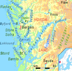
Hordaland
is a county in Norway, bordering Sogn og Fjordane, Buskerud, Telemark and Rogaland. Hordaland is the third largest county after Akershus and Oslo by population. The county administration is located in Bergen...
in Norway
Norway
Norway , officially the Kingdom of Norway, is a Nordic unitary constitutional monarchy whose territory comprises the western portion of the Scandinavian Peninsula, Jan Mayen, and the Arctic archipelago of Svalbard and Bouvet Island. Norway has a total area of and a population of about 4.9 million...
is the third largest fjord
Fjord
Geologically, a fjord is a long, narrow inlet with steep sides or cliffs, created in a valley carved by glacial activity.-Formation:A fjord is formed when a glacier cuts a U-shaped valley by abrasion of the surrounding bedrock. Glacial melting is accompanied by rebound of Earth's crust as the ice...
in the world and the second largest in Norway. The surrounding district
Districts of Norway
The country Norway is historically divided into a number of districts. Many districts have deep historical roots, and only partially coincide with today's administrative units of counties and municipalities. The districts are defined by geographical features, often valleys, mountain ranges, fjords,...
is called Hardanger
Hardanger
Hardanger is a traditional district in the western part of Norway, dominated by the Hardangerfjord. It consists of the municipalities of Odda, Ullensvang, Eidfjord, Ulvik, Granvin, Kvam and Jondal, and is located inside the county of Hordaland....
.
The Hardangerfjord starts at the Atlantic Ocean
Atlantic Ocean
The Atlantic Ocean is the second-largest of the world's oceanic divisions. With a total area of about , it covers approximately 20% of the Earth's surface and about 26% of its water surface area...
just south of Bergen (SW Norway). Here the fjord penetrates in a north easterly direction until it meets the grand mountain plateau of Hardangervidda
Hardangervidda
The Hardangervidda is a mountain plateau in the Hardanger region of western Norway. It is the largest such plateau in Europe, with a cold year-round alpine climate and is the site of one of Norway's largest glaciers. Much of the plateau is protected as part of Hardangervidda National Park; it is a...
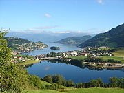
. The longest branch of the Hardangerfjord is Sørfjorden
Sørfjorden
-Finnmark county:*Sørfjorden , arm of the Mehamnfjorden in Gamvik*Sørfjorden , fjord on Stjernøya island in Hasvik*Sørfjorden , arm of the Mårøfjorden in Lebesby*Sørfjorden , arm of the Nuvsfjorden in Loppa-Hordaland county:...
which cuts south about 50 km from the main fjord. Its maximum depth is more than 800 m (2,624 ft) just outside Norheimsund
Norheimsund
Norheimsund is the municipal administrative centre of Kvam, Norway. The village is located on the northern side of the Hardangerfjord, about 80 km from Bergen. The waterfall Steinsdalsfossen, as of 2006 the 6th most visited natural tourist attraction in Norway, is located near Norheimsund. In...
in the middle of the fjord.
About 10,000 years ago the Scandinavia
Scandinavia
Scandinavia is a cultural, historical and ethno-linguistic region in northern Europe that includes the three kingdoms of Denmark, Norway and Sweden, characterized by their common ethno-cultural heritage and language. Modern Norway and Sweden proper are situated on the Scandinavian Peninsula,...
n land mass started to rise up as enormous glacial
Glacier
A glacier is a large persistent body of ice that forms where the accumulation of snow exceeds its ablation over many years, often centuries. At least 0.1 km² in area and 50 m thick, but often much larger, a glacier slowly deforms and flows due to stresses induced by its weight...
ice started to melt. The lower parts of the valleys became flooded, and so created what we today know as the Hardangerfjord. The valley was originally not only made through glacial erosion but by the high pressure melting water which pushed its way beneath the ice.
On the Folgefonn peninsula
Peninsula
A peninsula is a piece of land that is bordered by water on three sides but connected to mainland. In many Germanic and Celtic languages and also in Baltic, Slavic and Hungarian, peninsulas are called "half-islands"....
which belongs to the Hardangerfjord, the third largest glacier in Norway is found. With its three parts, the Folgefonn glacier covers an area of 220 km² (84.9 sq mi), and is an area which in 2005 became protected as a national park.
The history of the fjord goes far beyond its Viking
Viking
The term Viking is customarily used to refer to the Norse explorers, warriors, merchants, and pirates who raided, traded, explored and settled in wide areas of Europe, Asia and the North Atlantic islands from the late 8th to the mid-11th century.These Norsemen used their famed longships to...
history, back to the time of hunters on the surrounding mountains, and later on, farming along this fertile area which today is considered the fruit orchard of Norway. Later the fjord became the birthplace for a large tourism
Tourism
Tourism is travel for recreational, leisure or business purposes. The World Tourism Organization defines tourists as people "traveling to and staying in places outside their usual environment for not more than one consecutive year for leisure, business and other purposes".Tourism has become a...
influx to Norway, and in 1875 Thomas Cook
Thomas Cook
Thomas Cook of Melbourne, Derbyshire, England founded the travel agency that is now Thomas Cook Group.- Early days :...
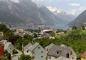
started weekly cruise departures from London to the Hardangerfjord, due to its spectacular nature, glaciers and grand waterfalls. Soon after this many of the major waterfalls became the power source for large industries in fjord settlements such as Odda
Odda
is a municipality and town in the county of Hordaland, Norway. Odda was separated from Ullensvang on 1 July 1913 and on 1 January 1964 Røldal was merged with Odda. The town of Odda is the centre of the landscape of Hardanger, located at the end of the Hardangerfjord.In 1927, Erling Johnson,...
.
Today the Hardangerfjord is witness to a renaissance in tourism and new infrastructure for travellers has once again become an industry for the local communities along the fjord.
The fjord has good conditions for fish farming
Fish farming
Fish farming is the principal form of aquaculture, while other methods may fall under mariculture. Fish farming involves raising fish commercially in tanks or enclosures, usually for food. A facility that releases young fish into the wild for recreational fishing or to supplement a species'...
. Fish farms yearly produce more than 40.000 tons of salmon
Salmon
Salmon is the common name for several species of fish in the family Salmonidae. Several other fish in the same family are called trout; the difference is often said to be that salmon migrate and trout are resident, but this distinction does not strictly hold true...
and rainbow trout
Rainbow trout
The rainbow trout is a species of salmonid native to tributaries of the Pacific Ocean in Asia and North America. The steelhead is a sea run rainbow trout usually returning to freshwater to spawn after 2 to 3 years at sea. In other words, rainbow trout and steelhead trout are the same species....
(2002) and makes the Hardangerfjord one of four major fish farming regions in the world.
Hardangerfjord's melt-water is also bottled at source to form the product Isklar
Isklar
Isklar is a brand of still and sparkling natural mineral water from the Folgefonna Glacier of Norway. It was first launched in the United Kingdom in early 2008. The company is backed by a multi-million Euro investment by renowned global conglomerate, the Indian-based Siva Group, SABCO, and Jova...
, sold worldwide.
The contemporary fjord is divided among the 13 municipalities Bømlo
Bømlo
Bømlo is a municipality in Sunnhordland, in the southern part of the county of Hordaland, Norway. It is also the name of the main island of this archipelago, consisting of about 900 islets, located west of Stord....
, Eidfjord
Eidfjord
Eidfjord is a municipality in the county of Hordaland, Norway. Eidfjord was separated from Ulvik May 1, 1891....
, Etne
Etne
Etne is a municipality in the county of Hordaland, Norway. Etne is located within the traditional district of Haugaland. Etne was established as a municipality on 1 January 1838 . Most of Skånevik was merged with Etne on 1 January 1965.-Name:The municipality is named after the Etnefjord...
, Granvin
Granvin
Granvin is a municipality in the county of Hordaland, Norway. The population is 964. About half of these, 444 people, live in the village of Granvin, situated at the end of a side arm of the Hardangerfjord.-Name:...
, Jondal
Jondal
Jondal is a municipality in the county of Hordaland, Norway. Jondal was separated from Strandebarm in 1846.-Name:The Old Norse form of the name was Jónardalr. The first element is an old rivername Jón and the last element is dalr which means "valley" or "dale"...
, Kvam
Kvam
Kvam is a municipality in the county of Hordaland, Norway. The parish of Vikør was established as a municipality on 1 January 1838 . Parts of Strandebarm were merged with Kvam on 1 January 1965...
, Kvinnherad
Kvinnherad
Kvinnherad is a municipality in the county of Hordaland, Norway. The parish of Kvindherred was established as a municipality on 1 January 1838 . Fjelberg, most of Varaldsøy and parts of Skånevik merged with Kvinnherad on 1 January 1965.The municipality is the 5th in size in Hordaland...
, Odda
Odda
is a municipality and town in the county of Hordaland, Norway. Odda was separated from Ullensvang on 1 July 1913 and on 1 January 1964 Røldal was merged with Odda. The town of Odda is the centre of the landscape of Hardanger, located at the end of the Hardangerfjord.In 1927, Erling Johnson,...
, Sund
Sund, Norway
Sund is a municipality in the county of Hordaland, Norway. Sund covers the southern part of the island of Store Sotra, west of Bergen, and many smaller, surrounding islands. The history of the municipality dates back to 1838, when Sund was first established as a formannskapsdistrikt, the precursor...
, Sveio
Sveio
Sveio is a municipality in the county of Hordaland, Norway. Sveio is located in the traditional district of Haugaland-Location:Geographically, Sveio is situated on the Haugaland peninsula. The administrative centre is the village of Sveio. Sveio was separated from Finnås in 1861. Vikebygd was...
, Tysnes
Tysnes
Tysnes is a municipality in the county of Hordaland, Norway. It is located in the traditional district of Sunnhordland. The administrative centre is the village of Uggdal....
, Ullensvang
Ullensvang
Ullensvang is a municipality in the county of Hordaland, Norway. It is located in the traditional district of Hardanger. The administrative centre is the village of Kinsarvik....
and Ulvik
Ulvik
Ulvik is a municipality in Hordaland county, Norway. The municipality stretches from the Hardangerfjord to 1,800 metres above sea level, and borders the municipalities of Granvin, Eidfjord, Ullensvang, Voss, Aurland, and Hol. It takes around two hours to drive from Bergen to Ulvik. The nearest...
. The total number of inhabitants for all these municipalities is only a bit more than 70 thousand - on a total area of 8,471 km².
Side fjords which connect with Hardangerfjord

- Entrance
- Husnesfjorden
- Lokksundet
- Onarheimsfjorden
- Storsundet
- Kvinnheradsfjorden
- Øynefjorden
- Bondesundet
- Sildefjorden
- Hissfjorden
- Strandebarmsbukta
- Ytre Samlafjorden
- Indre Samlafjorden
- Utnefjorden
- Granvinfjorden
- Eidfjorden
- Osafjorden
- Ulvikfjorden
- Osafjorden
- Sørfjorden
External links
- Svein Ulvund's collection (Beautiful pictures, not exclusively from the Hardangerfjord, but also from nearby places. Daily updated! Please note the search feature, to be used , e.g., with Hardanger and 2007.)