
Purnululu National Park
Encyclopedia
Purnululu National Park is a national park in the Kimberley region of Western Australia
. It was declared a World Heritage Site
in 2003.
to the north, or Halls Creek to the south.
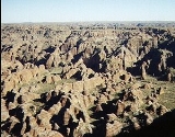
Purnululu is the name given to the sandstone
area of the Bungle Bungle Range
by the Kija
Aboriginal people. The name means sandstone or may be a corruption of bundle grass. The range, lying fully within the park, has elevations as high as 578 metres above sea level. It is famous for the sandstone domes, unusual and visually striking with their striping in alternating orange and grey bands. The banding of the domes is due to differences in clay content and porosity of the sandstone layers: the orange bands consist of oxidised iron
compounds in layers that dry out too quickly for cyanobacteria to multiply; the grey bands are composed of cyanobacteria growing on the surface of layers of sandstone where moisture accumulates.
approximately 250 km south of Kununurra, to the track's end at the visitor centre. The track is 53 km long and is usable only in the dry season (about 1 April to 31 December), and only by four-wheel-drive
(4WD) vehicles. Safely navigating it takes approximately 3 hours. Access by air is less demanding; helicopter flights are available, from Bellburn Airstrip in the national park, and light aircraft, from both Warmun, 187 km south of Kununurra, and Kununurra.
Western Australia
Western Australia is a state of Australia, occupying the entire western third of the Australian continent. It is bounded by the Indian Ocean to the north and west, the Great Australian Bight and Indian Ocean to the south, the Northern Territory to the north-east and South Australia to the south-east...
. It was declared a World Heritage Site
World Heritage Site
A UNESCO World Heritage Site is a place that is listed by the UNESCO as of special cultural or physical significance...
in 2003.
Location
It is located in north east of Western Australia. The nearest major town is KununurraKununurra, Western Australia
Kununurra is a town in far northern Western Australia located at the eastern extremity of the Kimberley Region approximately from the border with the Northern Territory. Kununurra was initiated to service the Ord River Irrigation scheme....
to the north, or Halls Creek to the south.
Purnululu is the name given to the sandstone
Sandstone
Sandstone is a sedimentary rock composed mainly of sand-sized minerals or rock grains.Most sandstone is composed of quartz and/or feldspar because these are the most common minerals in the Earth's crust. Like sand, sandstone may be any colour, but the most common colours are tan, brown, yellow,...
area of the Bungle Bungle Range
Bungle Bungle Range
Bungle Bungle Range is the landform that is the major component of the Purnululu National Park in Western Australia - it is often used as a direct synonym for the national park area.-The origin of the landscape :...
by the Kija
Kija
Kija or Gija can refer to:* The name of an Aboriginal people in Australia, see Kija people.* Their indigenous Kija language.* The leader of the obscure early Korean kingdom of Gija Joseon, see Jizi....
Aboriginal people. The name means sandstone or may be a corruption of bundle grass. The range, lying fully within the park, has elevations as high as 578 metres above sea level. It is famous for the sandstone domes, unusual and visually striking with their striping in alternating orange and grey bands. The banding of the domes is due to differences in clay content and porosity of the sandstone layers: the orange bands consist of oxidised iron
Iron
Iron is a chemical element with the symbol Fe and atomic number 26. It is a metal in the first transition series. It is the most common element forming the planet Earth as a whole, forming much of Earth's outer and inner core. It is the fourth most common element in the Earth's crust...
compounds in layers that dry out too quickly for cyanobacteria to multiply; the grey bands are composed of cyanobacteria growing on the surface of layers of sandstone where moisture accumulates.
Access
Access to the park by road is via Spring Creek Track, from the Great Northern HighwayGreat Northern Highway
The Great Northern Highway is a generally north-south Western Australian highway which links the state's capital Perth with its most northern port, Wyndham. It is in length, with being National Highway...
approximately 250 km south of Kununurra, to the track's end at the visitor centre. The track is 53 km long and is usable only in the dry season (about 1 April to 31 December), and only by four-wheel-drive
Sport utility vehicle
A sport utility vehicle is a generic marketing term for a vehicle similar to a station wagon, but built on a light-truck chassis. It is usually equipped with four-wheel drive for on- or off-road ability, and with some pretension or ability to be used as an off-road vehicle. Not all four-wheel...
(4WD) vehicles. Safely navigating it takes approximately 3 hours. Access by air is less demanding; helicopter flights are available, from Bellburn Airstrip in the national park, and light aircraft, from both Warmun, 187 km south of Kununurra, and Kununurra.
Further reading
- Hoatsan, Dean et al.(1997) Bungle Bungle Range : Purnululu National Park, East Kimberley, Western Australia : a guide to the rocks, landforms, plants, animals, and human impact Canberra : Australian Geological Survey Organisation. ISBN 0642250103