

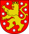
Thuringia
Encyclopedia
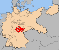
The Free State of Thuringia is a state
of Germany
, located in the central part of the country.
It has an area of 16171 square kilometres (6,243.7 sq mi) and 2.29 million inhabitants, making it the sixth smallest by area and the fifth smallest by population of Germany's sixteen states.
Most of Thuringia is within the watershed of the Saale
, a left tributary of the Elbe. Its capital is Erfurt
.
Thuringia has been known by the nickname of "the green heart of Germany" (das grüne Herz Deutschlands) from the late 19th century, due to the dense forest that covers the terrain.
Thuringia is well known in Germany for nature and winter sports. It is home to the Rennsteig
, Germany's most famous hiking trail
, and the winter resort of Oberhof
. Germany won more Winter Olympics gold medals than any other country in the last 20 years, and half of Germany's gold medals have been won by Thuringian athletes.
, Saxony-Anhalt
, Saxony
, Bavaria
and Hesse
. The ridges of the western Harz
Mountains divide the region from Lower Saxony on the north-west, while the eastern Harz similarly separates Thuringia from the state of Saxony-Anhalt to the north-east. To the south and southwest, the Thuringian Forest
effectively separates the ancient region of Franconia
, now the northern part of Bavaria, from the rolling plains of most of Thuringia. The central Harz range extends southwards along the western side into the northwest corner of the Thuringian Forest region, making Thuringia a lowland basin of rolling plains nearly surrounded by ancient somewhat-difficult mountains. To the west across the mountains and south is the drainage basin of the Rhine River.
The most conspicuous geographical feature of Thuringia is the Thuringian Forest
, a mountain chain in the southwest.
The Werra
River, a tributary of the Weser
River, separates this mountain chain from the volcanic Rhön Mountains
, which are partially in Thuringia, Bavaria, and Hesse. In the northwest, Thuringia includes a small part of the Harz. The eastern part of Thuringia is generally a plain. The Saale
River runs through these lowlands from south to north.
The geographic center
of the Federal Republic
is located in Thuringia, near the municipality of Niederdorla
.
See also List of places in Thuringia.
Thuringia is divided into 17 districts (Landkreise):
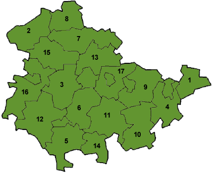
Furthermore there are six urban districts (not numerated in the map):
Each of the urban districts contains a town of the same name (see table below, "Towns in Thuringia").
tribe who occupied it ca. AD 300, Thuringia came under Frankish
domination in the 6th century, forming a part of the subsequent Holy Roman Empire
.
 Thuringia became a landgraviate in 1130. After the extinction of the reigning Ludowingian line of counts in 1247 and the War of the Thuringian Succession
(1247–1264), the western half became independent under the name of Hesse
, never to become a part of Thuringia again. Most of the remaining Thuringia came under the rule of the Wettin dynasty of the nearby Margraviate of Meissen, the nucleus of the later Electorate
and Kingdom of Saxony
. With the division of the house of Wettin in 1485, Thuringia went to the senior Ernestine branch of the family, which subsequently subdivided the area into a number of smaller states, according to the Saxon tradition of dividing inheritance amongst male heirs. These were the "Saxon duchies
", consisting, among others, of the states of Saxe-Weimar
, Saxe-Eisenach
, Saxe-Jena
, Saxe-Meiningen
, Saxe-Altenburg
, Saxe-Coburg
, and Saxe-Gotha
; Thuringia became merely a geographical concept.
Thuringia generally accepted the Protestant Reformation
. The Catholic faith
was abolished as early as 1520; priests that remained loyal were driven away and churches and monasteries were largely destroyed, especially during the German Peasants' War
of 1525. In Mühlhausen
and elsewhere, the Anabaptists found many adherents. Thomas Müntzer, a leader of some non-peaceful groups of this sect, was active in this city. Within the borders of Thuringia the Catholic faith was maintained only in the district called Eichsfeld
, which was ruled by the Archbishop of Mainz
, and to a small degree in the city and vicinity of Erfurt
.
 Some reordering of the Thuringian states occurred during the German Mediatisation
from 1795–1814, and the territory was included within the Napoleonic Confederation of the Rhine
organized in 1806. The 1815 Congress of Vienna
confirmed these changes and the Thuringian states' inclusion in the German Confederation
; the Kingdom of Prussia
also acquired some Thuringian territory and administered it within the Province of Saxony
. The Thuringian duchies which became part of the German Empire
in 1871 during the Prussian-led unification of Germany
were Saxe-Weimar-Eisenach
, Saxe-Meiningen
, Saxe-Altenburg
, Saxe-Coburg-Gotha, Schwarzburg-Sondershausen
, Schwarzburg-Rudolstadt
and the two principalities of Reuss Elder Line
and Reuss Younger Line. In 1920, after World War I
, these small states merged into one state, called Thuringia; only Saxe-Coburg
voted to join Bavaria
instead. Weimar
became the new capital of Thuringia. The coat of arms of this new state was simpler than they had been previously.
 After briefly being controlled by the USA
, from July 1945, the state of Thuringia came under the Soviet occupation zone, and was expanded to include parts Prussian Saxony, such as the areas around Erfurt
, Mühlhausen
, and Nordhausen
. Erfurt became the new capital of Thuringia.
In 1952, the German Democratic Republic
dissolved its states, and created districts (Bezirke
) instead. The three districts that shared the territory of Thuringia were based in Erfurt, Gera
and Suhl
.
The State of Thuringia was restored with slightly altered borders during Germany's reunification
in 1990.
States of Germany
Germany is made up of sixteen which are partly sovereign constituent states of the Federal Republic of Germany. Land literally translates as "country", and constitutionally speaking, they are constituent countries...
of Germany
Germany
Germany , officially the Federal Republic of Germany , is a federal parliamentary republic in Europe. The country consists of 16 states while the capital and largest city is Berlin. Germany covers an area of 357,021 km2 and has a largely temperate seasonal climate...
, located in the central part of the country.
It has an area of 16171 square kilometres (6,243.7 sq mi) and 2.29 million inhabitants, making it the sixth smallest by area and the fifth smallest by population of Germany's sixteen states.
Most of Thuringia is within the watershed of the Saale
Saale
The Saale, also known as the Saxon Saale and Thuringian Saale , is a river in Germany and a left-bank tributary of the Elbe. It is not to be confused with the smaller Franconian Saale, a right-bank tributary of the Main, or the Saale in Lower Saxony, a tributary of the Leine.-Course:The Saale...
, a left tributary of the Elbe. Its capital is Erfurt
Erfurt
Erfurt is the capital city of Thuringia and the main city nearest to the geographical centre of Germany, located 100 km SW of Leipzig, 150 km N of Nuremberg and 180 km SE of Hannover. Erfurt Airport can be reached by plane via Munich. It lies in the southern part of the Thuringian...
.
Thuringia has been known by the nickname of "the green heart of Germany" (das grüne Herz Deutschlands) from the late 19th century, due to the dense forest that covers the terrain.
Thuringia is well known in Germany for nature and winter sports. It is home to the Rennsteig
Rennsteig
The Rennsteig is a ridge walk as well as an historical boundary path in the Thuringian Forest, Thuringian Highland and Franconian Forest in central Germany....
, Germany's most famous hiking trail
Hiking
Hiking is an outdoor activity which consists of walking in natural environments, often in mountainous or other scenic terrain. People often hike on hiking trails. It is such a popular activity that there are numerous hiking organizations worldwide. The health benefits of different types of hiking...
, and the winter resort of Oberhof
Oberhof, Germany
Oberhof is a town in the Schmalkalden-Meiningen district of Thuringia, Germany. It is a winter sports center and health resort. It is visited by tenfold as many tourists every year...
. Germany won more Winter Olympics gold medals than any other country in the last 20 years, and half of Germany's gold medals have been won by Thuringian athletes.
Geography
From the northwest going clockwise, Thuringia borders on the German states of Lower SaxonyLower Saxony
Lower Saxony is a German state situated in north-western Germany and is second in area and fourth in population among the sixteen states of Germany...
, Saxony-Anhalt
Saxony-Anhalt
Saxony-Anhalt is a landlocked state of Germany. Its capital is Magdeburg and it is surrounded by the German states of Lower Saxony, Brandenburg, Saxony, and Thuringia.Saxony-Anhalt covers an area of...
, Saxony
Saxony
The Free State of Saxony is a landlocked state of Germany, contingent with Brandenburg, Saxony Anhalt, Thuringia, Bavaria, the Czech Republic and Poland. It is the tenth-largest German state in area, with of Germany's sixteen states....
, Bavaria
Bavaria
Bavaria, formally the Free State of Bavaria is a state of Germany, located in the southeast of Germany. With an area of , it is the largest state by area, forming almost 20% of the total land area of Germany...
and Hesse
Hesse
Hesse or Hessia is both a cultural region of Germany and the name of an individual German state.* The cultural region of Hesse includes both the State of Hesse and the area known as Rhenish Hesse in the neighbouring Rhineland-Palatinate state...
. The ridges of the western Harz
Harz
The Harz is the highest mountain range in northern Germany and its rugged terrain extends across parts of Lower Saxony, Saxony-Anhalt and Thuringia. The name Harz derives from the Middle High German word Hardt or Hart , latinized as Hercynia. The legendary Brocken is the highest summit in the Harz...
Mountains divide the region from Lower Saxony on the north-west, while the eastern Harz similarly separates Thuringia from the state of Saxony-Anhalt to the north-east. To the south and southwest, the Thuringian Forest
Thuringian Forest
The Thuringian Forest running northwest to southeast, forms a continuous stretch of ancient rounded mountains posing ample difficulties in transit routing save through a few navigable passes in the southern reaches of the German state of Thuringia. It is about long and wide...
effectively separates the ancient region of Franconia
Franconia
Franconia is a region of Germany comprising the northern parts of the modern state of Bavaria, a small part of southern Thuringia, and a region in northeastern Baden-Württemberg called Tauberfranken...
, now the northern part of Bavaria, from the rolling plains of most of Thuringia. The central Harz range extends southwards along the western side into the northwest corner of the Thuringian Forest region, making Thuringia a lowland basin of rolling plains nearly surrounded by ancient somewhat-difficult mountains. To the west across the mountains and south is the drainage basin of the Rhine River.
The most conspicuous geographical feature of Thuringia is the Thuringian Forest
Thuringian Forest
The Thuringian Forest running northwest to southeast, forms a continuous stretch of ancient rounded mountains posing ample difficulties in transit routing save through a few navigable passes in the southern reaches of the German state of Thuringia. It is about long and wide...
, a mountain chain in the southwest.
The Werra
Werra
The Werra is a river in central Germany, the right-source river of the Weser. The Werra has its source near Eisfeld in southern Thuringia. After 293 km the Werra joins the river Fulda in the town of Hann. Münden, forming the Weser....
River, a tributary of the Weser
Weser River
The Weser is a river in north-western Germany. Formed at Hann. Münden by the Fulda and Werra, it flows through Lower Saxony, then reaching the historic port city of Bremen before emptying into the North Sea 50 km further north at Bremerhaven, which is also a seaport...
River, separates this mountain chain from the volcanic Rhön Mountains
Rhön Mountains
The Rhön Mountains are a group of low mountains in central Germany, located around the border area where the states of Hesse, Bavaria and Thuringia come together. These mountains, which are at the extreme southeast end of the East Hesse Highlands , are partly a result of ancient volcanic activity...
, which are partially in Thuringia, Bavaria, and Hesse. In the northwest, Thuringia includes a small part of the Harz. The eastern part of Thuringia is generally a plain. The Saale
Saale
The Saale, also known as the Saxon Saale and Thuringian Saale , is a river in Germany and a left-bank tributary of the Elbe. It is not to be confused with the smaller Franconian Saale, a right-bank tributary of the Main, or the Saale in Lower Saxony, a tributary of the Leine.-Course:The Saale...
River runs through these lowlands from south to north.
The geographic center
Centroid
In geometry, the centroid, geometric center, or barycenter of a plane figure or two-dimensional shape X is the intersection of all straight lines that divide X into two parts of equal moment about the line. Informally, it is the "average" of all points of X...
of the Federal Republic
Germany
Germany , officially the Federal Republic of Germany , is a federal parliamentary republic in Europe. The country consists of 16 states while the capital and largest city is Berlin. Germany covers an area of 357,021 km2 and has a largely temperate seasonal climate...
is located in Thuringia, near the municipality of Niederdorla
Niederdorla
Niederdorla is a municipality in the Unstrut-Hainich district of Thuringia, Germany. It is the geographical center of Germany. Its nearest main city is Erfurt, which is also t the capital city of Thuringia.- People from Niederdorla :...
.
See also List of places in Thuringia.
Thuringia is divided into 17 districts (Landkreise):
|
|
|
Furthermore there are six urban districts (not numerated in the map):
- ErfurtErfurtErfurt is the capital city of Thuringia and the main city nearest to the geographical centre of Germany, located 100 km SW of Leipzig, 150 km N of Nuremberg and 180 km SE of Hannover. Erfurt Airport can be reached by plane via Munich. It lies in the southern part of the Thuringian...
- Eisenach
- GeraGeraGera, the third-largest city in the German state of Thuringia , lies in east Thuringia on the river Weiße Elster, approximately 60 kilometres to the south of the city of Leipzig and 80 kilometres to the east of Erfurt...
- JenaJenaJena is a university city in central Germany on the river Saale. It has a population of approx. 103,000 and is the second largest city in the federal state of Thuringia, after Erfurt.-History:Jena was first mentioned in an 1182 document...
- SuhlSuhl- Geography :Suhl sits on the south edge of the Suhler Scholle, an upthrust granite complex that is streaked by numerous dikes. This is part of the Ruhla-Schleusingen Horst that defines the southwest side of the Thuringian Forest...
- WeimarWeimarWeimar is a city in Germany famous for its cultural heritage. It is located in the federal state of Thuringia , north of the Thüringer Wald, east of Erfurt, and southwest of Halle and Leipzig. Its current population is approximately 65,000. The oldest record of the city dates from the year 899...
Each of the urban districts contains a town of the same name (see table below, "Towns in Thuringia").
Towns
| Towns in Thuringia | |||||
| position | town | inhabitants | district | ||
| 31 December 1970 | 31 December 2000 | 30 June 2005 | |||
| 1. | Erfurt Erfurt Erfurt is the capital city of Thuringia and the main city nearest to the geographical centre of Germany, located 100 km SW of Leipzig, 150 km N of Nuremberg and 180 km SE of Hannover. Erfurt Airport can be reached by plane via Munich. It lies in the southern part of the Thuringian... |
192.679 | 200.564 | 202.590 | independent city |
| 2. | Gera Gera Gera, the third-largest city in the German state of Thuringia , lies in east Thuringia on the river Weiße Elster, approximately 60 kilometres to the south of the city of Leipzig and 80 kilometres to the east of Erfurt... |
106.841 | 112.835 | 104.737 | independent city |
| 3. | Jena Jena Jena is a university city in central Germany on the river Saale. It has a population of approx. 103,000 and is the second largest city in the federal state of Thuringia, after Erfurt.-History:Jena was first mentioned in an 1182 document... |
85.169 | 99.893 | 102.201 | independent city |
| 4. | Weimar Weimar Weimar is a city in Germany famous for its cultural heritage. It is located in the federal state of Thuringia , north of the Thüringer Wald, east of Erfurt, and southwest of Halle and Leipzig. Its current population is approximately 65,000. The oldest record of the city dates from the year 899... |
63.985 | 62.425 | 64.361 | independent city |
| 5. | Gotha Gotha (town) Gotha is a town in Thuringia, within the central core of Germany. It is the capital of the district of Gotha.- History :The town has existed at least since the 8th century, when it was mentioned in a document signed by Charlemagne as Villa Gotaha . Its importance derives from having been chosen in... |
57.256 | 48.376 | 47.045 | Gotha |
| 6. | Eisenach Eisenach Eisenach is a city in Thuringia, Germany. It is situated between the northern foothills of the Thuringian Forest and the Hainich National Park. Its population in 2006 was 43,626.-History:... |
50.059 | 44.442 | 37.858 | independent city |
| 7. | Nordhausen Nordhausen Nordhausen is a town at the southern edge of the Harz Mountains, in the state of Thuringia, Germany. It is the capital of the district of Nordhausen... |
42.018 | 45.633 | 43.781 | Nordhausen |
| 8. | Suhl Suhl - Geography :Suhl sits on the south edge of the Suhler Scholle, an upthrust granite complex that is streaked by numerous dikes. This is part of the Ruhla-Schleusingen Horst that defines the southwest side of the Thuringian Forest... |
28.177 | 48.025 | 43.202 | independent city |
| 9. | Altenburg Altenburg Altenburg is a town in the German federal state of Thuringia, 45 km south of Leipzig. It is the capital of the Altenburger Land district.-Geography:... |
47.497 | 41.290 | 38.203 | Altenburger Land |
| 10. | Meiningen Meiningen Meiningen is a town in Germany - located in the southern part of the state of Thuringia and is the district seat of Schmalkalden-Meiningen. It is situated on the river Werra.... |
34.876 | 32.240 | 37.642 | Schmalkalden-Meiningen |
| 11. | Mühlhausen Mühlhausen Mühlhausen is a city in the federal state of Thuringia, Germany. It is the capital of the Unstrut-Hainich district, and lies along the river Unstrut. Mühlhausen had c. 37,000 inhabitants in 2006.-History:... |
46.135 | 38.695 | 37.480 | Unstrut-Hainich-Kreis |
| 12. | Saalfeld | 31.048 | 29.511 | 28.148 | Saalfeld-Rudolstadt |
| 13. | Ilmenau Ilmenau Ilmenau is a town located in the district of Ilm-Kreis, Thuringia, Germany.Ilmenau is situated in the valley of the Ilm river, at an altitude of 431 metres above sea level, and is the biggest town in Ilm-Kreis district, with 6,200 students studying at the Technische Universität Ilmenau. The... |
19.634 | 27.176 | 26.713 | Ilm-Kreis Ilm-Kreis Ilm-Kreis is a district in Thuringia, Germany. It is bounded by the city of Erfurt, the districts of Weimarer Land, Saalfeld-Rudolstadt and Hildburghausen, the city of Suhl, and the districts of Schmalkalden-Meiningen and Gotha... |
| 14. | Arnstadt Arnstadt Arnstadt is a town in Ilm-Kreis, Thuringia, Germany, situated on the Gera River. It is one of the oldest towns in Thuringia and is nicknamed Das Tor zum Thüringer Wald, The Gate to the Thuringian Forest.... |
27.368 | 27.220 | 25.828 | Ilm-Kreis Ilm-Kreis Ilm-Kreis is a district in Thuringia, Germany. It is bounded by the city of Erfurt, the districts of Weimarer Land, Saalfeld-Rudolstadt and Hildburghausen, the city of Suhl, and the districts of Schmalkalden-Meiningen and Gotha... |
| 15. | Rudolstadt Rudolstadt Rudolstadt is a town in the German Bundesland of Thuringia, close to the Thuringian Forest to the southwest, and to Jena and Weimar to the north.... |
30.087 | 27.528 | 25.584 | Saalfeld-Rudolstadt |
| 16. | Apolda Apolda Apolda is a town in central Thuringia, Germany, the capital of the Weimarer Land district. It is situated in the center of the triangle Weimar - Jena - Naumburg near the river Ilm, c. 15 km east by north from Weimar, on the main line of railway from Berlin via Halle, to... |
29.754 | 25.899 | 24.684 | Weimarer Land |
| 17. | Greiz Greiz Greiz is a town in Thuringia, and it is the capital of the district of Greiz. Greiz is situated in eastern Thuringia on the river Weiße Elster.... |
39.424 | 26.177 | 24.007 | Greiz |
| 18. | Sonneberg Sonneberg Sonneberg is a town in Thuringia, Germany, which is seat of the district Sonneberg.It has long been a centre of toy making and is still well known for this... |
29.811 | 24.837 | 23.928 | Sonneberg |
| 19. | Sondershausen Sondershausen Sondershausen is a town in Thuringia, Germany, capital of the Kyffhäuserkreis district, situated about 50 km north of Erfurt. On 1 December 2007, the former municipality Schernberg was incorporated by Sondershausen.... |
22.195 | 23.088 | 21.718 | Kyffhäuserkreis Kyffhäuserkreis The Kyffhäuserkreis is a district in the northern part of Thuringia, Germany. Neighboring districts are the districts Mansfeld-Südharz, Saalekreis und Burgenlandkreis in Saxony-Anhalt, and the districts Sömmerda, Unstrut-Hainich and Eichsfeld.-History:... |
| 20. | Sömmerda Sömmerda Sömmerda is a town near Erfurt in Thuringia, Germany, on the Unstrut river. It is the capital of the district of Sömmerda.-History:Archeological digs in the area that is now Sömmerda, formerly Leubingen, have uncovered prominently buried human remains dating to around 2000 BCE... |
15.959 | 21.977 | 20.885 | Sömmerda |
| 21. | Leinefelde-Worbis Leinefelde-Worbis “”Leinefelde-Worbis is a town in the district of Eichsfeld, in northwestern Thuringia, Germany. The town was formed on March 16, 2004, from the former independent towns Leinefelde and Worbis along with the municipalities of Breitenbach and Wintzingerode... (formed on 16 March 2004) |
4.315 (LF) 3.401 (WO) |
15.056 (LF) 5.497 (WO) |
20.816 | Eichsfeld |
| 22. | Bad Langensalza Bad Langensalza Bad Langensalza is a city in the County of Unstrut-Hainich, Thuringia, Germany, with a population of c. 18,500 .-History:... |
16.813 | 19.917 | 18.760 | Unstrut-Hainich-Kreis |
| 23. | Schmalkalden Schmalkalden - Notable people :*Christoph Cellarius, scholar, born 22 November 1638, died 4 June 1707 in Halle*Christian Karl August Ludwig von Massenbach, colonel, born 16 April 1758, died 21 November 1827 at Białokosz... |
14.527 | 18.551 | 17.893 | Schmalkalden-Meiningen |
| 24. | Zeulenroda-Triebes Zeulenroda-Triebes Zeulenroda-Triebes is a German town in the district of Greiz in the state of Thuringia.Zeulenroda-Triebes is situated in the south of Greiz in the mountains of the Thuringian Slate Mountains , on the border with Saxonia. The population of Zeulenroda-Triebes in 2006 was about 18000. The largest... (formed on 1 March 2006) |
13.549 (ZR) 4.790 (TR) |
14.600 (ZR) 4.230 (TR) |
17.702 | Greiz |
| 25. | Heiligenstadt Heilbad Heiligenstadt Heilbad Heiligenstadt is a spa town in Thuringia, Germany. It is the capital of the Eichsfeld district.-Geography:Heiligenstadt is approximately 14 km east of the tripoint where the states of Thuringia, Hesse and Lower Saxony meet... |
12.464 | 17.291 | 17.175 | Eichsfeld |
| 26. | Bad Salzungen Bad Salzungen Bad Salzungen is a town in Thuringia, Germany. It is the capital of the Wartburgkreis district. It is situated on the river Werra, 5 km east of Tiefenort and 20 km south of Eisenach. Near the town, there's a Bundeswehr barrack, the Werratal-Kaserne, which was built in 1972 for the GDR Army.... |
11.466 | 17.086 | 16.551 | Wartburgkreis Wartburgkreis Wartburgkreis is a Kreis in the west of Thuringia, Germany. Neighboring districts are the districts Unstrut-Hainich, Gotha, Schmalkalden-Meiningen, and the districts Fulda, Hersfeld-Rotenburg and Werra-Meißner in Hesse... |
| 27. | Pößneck Pößneck Pößneck is a town in the Saale-Orla-Kreis district, in Thuringia, Germany. It is situated 19 km east of Rudolstadt, and 26 km south of Jena.... |
19.547 | 14.341 | 13.592 | Saale-Orla-Kreis Saale-Orla-Kreis Saale-Orla is a Kreis in the east of Thuringia, Germany. Neighboring districts are the districts Saale-Holzland, Greiz, the Vogtlandkreis in Saxony, the Bavarian districts Hof and Kronach, and the district Saalfeld-Rudolstadt.-History:The district was created in 1994 by merging the previous... |
| 28. | Schmölln Schmölln Schmölln is a town in the Thuringian, Germany, landkreis of Altenburger Land, and which lies on the river Sprotte.-Neighboring municipalities:... |
13.968 | 13.193 | 12.693 | Altenburger Land Altenburger Land Altenburger Land is a district in Thuringia, Germany. It is bounded by the district of Greiz, the Burgenlandkreis , and the districts Leipziger Land, Mittweida, Chemnitzer Land, Zwickauer Land in Saxony.- History :... |
| 29. | Zella-Mehlis Zella-Mehlis Zella-Mehlis is a town in the Schmalkalden-Meiningen district, in Thuringia, Germany. It is situated in the Thuringian Forest, 5 km north of Suhl, and 20 km east of Meiningen. The town of Zella-Mehlis is the site of the original Walther arms weapons factory. It remained there until the... (formed on 1 April 1919) |
17.136 | 13.036 | 12.355 | Schmalkalden-Meiningen |
| 30. | Hildburghausen Hildburghausen Hildburghausen is a town in Thuringia in central Germany, capital of the district Hildburghausen. It is situated on the river Werra, 20 km south of Suhl, and 25 km northwest of Coburg.... |
10.652 | 12.466 | 12.351 | Hildburghausen |
| 31. | Eisenberg Eisenberg, Thuringia Eisenberg is a town in Thuringia, Germany. It is the capital of the district Saale-Holzland.Neighboring municipalities are Jena and Gera . West of Eisenberg runs the motorway A 9 from Berlin to Munich... |
13.859 | 11.764 | 11.489 | Saale-Holzland-Kreis |
| 32. | Waltershausen Waltershausen Waltershausen is a city in the district of Gotha, Thuringia, Germany.The town has a population of 11475 .-Sister cities: Bruay-sur-l'Escaut, France Korbach, Germany Wolbrom, Poland Hanau, Germany -External links:*... |
14.219 | 11.725 | 11.307 | Gotha |
History
Named after the ThuringiiThuringii
The Thuringii or Toringi were a Germanic tribe which appeared late during the Völkerwanderung in the Harz Mountains of central Germania around 280, in a region which still bears their name to this day — Thuringia. They evidently filled a void left when the previous inhabitants — the...
tribe who occupied it ca. AD 300, Thuringia came under Frankish
Franks
The Franks were a confederation of Germanic tribes first attested in the third century AD as living north and east of the Lower Rhine River. From the third to fifth centuries some Franks raided Roman territory while other Franks joined the Roman troops in Gaul. Only the Salian Franks formed a...
domination in the 6th century, forming a part of the subsequent Holy Roman Empire
Holy Roman Empire
The Holy Roman Empire was a realm that existed from 962 to 1806 in Central Europe.It was ruled by the Holy Roman Emperor. Its character changed during the Middle Ages and the Early Modern period, when the power of the emperor gradually weakened in favour of the princes...
.
War of the Thuringian Succession
The War of the Thuringen Succession was a military battle over a successor to the last Landgrave of Thuringia in present-day Germany.- Source of the conflict :...
(1247–1264), the western half became independent under the name of Hesse
Hesse
Hesse or Hessia is both a cultural region of Germany and the name of an individual German state.* The cultural region of Hesse includes both the State of Hesse and the area known as Rhenish Hesse in the neighbouring Rhineland-Palatinate state...
, never to become a part of Thuringia again. Most of the remaining Thuringia came under the rule of the Wettin dynasty of the nearby Margraviate of Meissen, the nucleus of the later Electorate
Electorate of Saxony
The Electorate of Saxony , sometimes referred to as Upper Saxony, was a State of the Holy Roman Empire. It was established when Emperor Charles IV raised the Ascanian duchy of Saxe-Wittenberg to the status of an Electorate by the Golden Bull of 1356...
and Kingdom of Saxony
Kingdom of Saxony
The Kingdom of Saxony , lasting between 1806 and 1918, was an independent member of a number of historical confederacies in Napoleonic through post-Napoleonic Germany. From 1871 it was part of the German Empire. It became a Free state in the era of Weimar Republic in 1918 after the end of World War...
. With the division of the house of Wettin in 1485, Thuringia went to the senior Ernestine branch of the family, which subsequently subdivided the area into a number of smaller states, according to the Saxon tradition of dividing inheritance amongst male heirs. These were the "Saxon duchies
Ernestine duchies
The Ernestine duchies, also called the Saxon duchies , were a changing number of small states largely located in the present German state of Thuringia, governed by dukes of the Ernestine line of the House of Wettin.-Overview:The...
", consisting, among others, of the states of Saxe-Weimar
Saxe-Weimar
Saxe-Weimar was one of the Saxon duchies held by the Ernestine branch of the Wettin dynasty in present-day Thuringia. The chief town and capital was Weimar.-Division of Leipzig:...
, Saxe-Eisenach
Saxe-Eisenach
Saxe-Eisenach was the name of an Ernestine duchy ruled by the Saxon House of Wettin. The State intermittendly existed at three different times in the Thuringian region of the Holy Roman Empire...
, Saxe-Jena
Saxe-Jena
The Duchy of Saxe-Jena was one of the Saxon Duchies held by the Ernestine line of the Wettin Dynasty. Established in 1672 for Bernhard, fourth son of Wilhelm, Duke of Saxe-Weimar, Saxe-Jena was reincorporated into Saxe-Weimar on the extinction of Bernhard's line in 1690.-Dukes of Saxe-Jena:*...
, Saxe-Meiningen
Saxe-Meiningen
The Duchy of Saxe-Meiningen was one of the Saxon duchies held by the Ernestine line of the Wettin dynasty, located in the southwest of the present-day German state of Thuringia....
, Saxe-Altenburg
Saxe-Altenburg
Saxe-Altenburg was one of the Saxon duchies held by the Ernestine branch of the Wettin dynasty in present-day Thuringia.-History:The duchy originated from the medieval Burgraviate of Altenburg in the Imperial Pleissnerland , a possession of the Wettin Margraves of Meissen since 1243...
, Saxe-Coburg
Saxe-Coburg
Saxe-Coburg was a duchy held by the Ernestine branch of the Wettin dynasty in today's Bavaria, Germany.After the Division of Erfurt in 1572, Coburg was part of the Duchy of Saxe-Coburg-Eisenach, ruled by the Ernestine duke John Casimir jointly with his brother John Ernest. In 1596...
, and Saxe-Gotha
Saxe-Gotha
Saxe-Gotha was one of the Saxon duchies held by the Ernestine of the Wettin dynasty in the former Landgraviate of Thuringia. The ducal residence was erected at Gotha....
; Thuringia became merely a geographical concept.
Thuringia generally accepted the Protestant Reformation
Protestant Reformation
The Protestant Reformation was a 16th-century split within Western Christianity initiated by Martin Luther, John Calvin and other early Protestants. The efforts of the self-described "reformers", who objected to the doctrines, rituals and ecclesiastical structure of the Roman Catholic Church, led...
. The Catholic faith
Roman Catholic Church
The Catholic Church, also known as the Roman Catholic Church, is the world's largest Christian church, with over a billion members. Led by the Pope, it defines its mission as spreading the gospel of Jesus Christ, administering the sacraments and exercising charity...
was abolished as early as 1520; priests that remained loyal were driven away and churches and monasteries were largely destroyed, especially during the German Peasants' War
German Peasants' War
The German Peasants' War or Great Peasants' Revolt was a widespread popular revolt in the German-speaking areas of Central Europe, 1524–1526. At its height in the spring and summer of 1525, the conflict involved an estimated 300,000 peasants: contemporary estimates put the dead at 100,000...
of 1525. In Mühlhausen
Mühlhausen
Mühlhausen is a city in the federal state of Thuringia, Germany. It is the capital of the Unstrut-Hainich district, and lies along the river Unstrut. Mühlhausen had c. 37,000 inhabitants in 2006.-History:...
and elsewhere, the Anabaptists found many adherents. Thomas Müntzer, a leader of some non-peaceful groups of this sect, was active in this city. Within the borders of Thuringia the Catholic faith was maintained only in the district called Eichsfeld
Eichsfeld
The Eichsfeld is a historical region in the southeast of Lower Saxony and northwest of Thuringia in the south of the Harz mountains...
, which was ruled by the Archbishop of Mainz
Archbishopric of Mainz
The Archbishopric of Mainz or Electorate of Mainz was an influential ecclesiastic and secular prince-bishopric in the Holy Roman Empire between 780–82 and 1802. In the Roman Catholic Church hierarchy, the Archbishop of Mainz was the primas Germaniae, the substitute of the Pope north of the Alps...
, and to a small degree in the city and vicinity of Erfurt
Erfurt
Erfurt is the capital city of Thuringia and the main city nearest to the geographical centre of Germany, located 100 km SW of Leipzig, 150 km N of Nuremberg and 180 km SE of Hannover. Erfurt Airport can be reached by plane via Munich. It lies in the southern part of the Thuringian...
.
German Mediatisation
The German Mediatisation was the series of mediatisations and secularisations that occurred in Germany between 1795 and 1814, during the latter part of the era of the French Revolution and then the Napoleonic Era....
from 1795–1814, and the territory was included within the Napoleonic Confederation of the Rhine
Confederation of the Rhine
The Confederation of the Rhine was a confederation of client states of the First French Empire. It was formed initially from 16 German states by Napoleon after he defeated Austria's Francis II and Russia's Alexander I in the Battle of Austerlitz. The Treaty of Pressburg, in effect, led to the...
organized in 1806. The 1815 Congress of Vienna
Congress of Vienna
The Congress of Vienna was a conference of ambassadors of European states chaired by Klemens Wenzel von Metternich, and held in Vienna from September, 1814 to June, 1815. The objective of the Congress was to settle the many issues arising from the French Revolutionary Wars, the Napoleonic Wars,...
confirmed these changes and the Thuringian states' inclusion in the German Confederation
German Confederation
The German Confederation was the loose association of Central European states created by the Congress of Vienna in 1815 to coordinate the economies of separate German-speaking countries. It acted as a buffer between the powerful states of Austria and Prussia...
; the Kingdom of Prussia
Kingdom of Prussia
The Kingdom of Prussia was a German kingdom from 1701 to 1918. Until the defeat of Germany in World War I, it comprised almost two-thirds of the area of the German Empire...
also acquired some Thuringian territory and administered it within the Province of Saxony
Province of Saxony
The Province of Saxony was a province of the Kingdom of Prussia and later the Free State of Prussia from 1816 until 1945. Its capital was Magdeburg.-History:The province was created in 1816 out of the following territories:...
. The Thuringian duchies which became part of the German Empire
German Empire
The German Empire refers to Germany during the "Second Reich" period from the unification of Germany and proclamation of Wilhelm I as German Emperor on 18 January 1871, to 1918, when it became a federal republic after defeat in World War I and the abdication of the Emperor, Wilhelm II.The German...
in 1871 during the Prussian-led unification of Germany
Unification of Germany
The formal unification of Germany into a politically and administratively integrated nation state officially occurred on 18 January 1871 at the Versailles Palace's Hall of Mirrors in France. Princes of the German states gathered there to proclaim Wilhelm of Prussia as Emperor Wilhelm of the German...
were Saxe-Weimar-Eisenach
Saxe-Weimar-Eisenach
The Duchy of Saxe-Weimar-Eisenach was created in 1809 by the merger of the Ernestine duchies of Saxe-Weimar and Saxe-Eisenach. It was raised to a Grand duchy in 1815 by resolution of the Vienna Congress. In 1877, it officially changed its name to the Grand Duchy of Saxony , but this name was...
, Saxe-Meiningen
Saxe-Meiningen
The Duchy of Saxe-Meiningen was one of the Saxon duchies held by the Ernestine line of the Wettin dynasty, located in the southwest of the present-day German state of Thuringia....
, Saxe-Altenburg
Saxe-Altenburg
Saxe-Altenburg was one of the Saxon duchies held by the Ernestine branch of the Wettin dynasty in present-day Thuringia.-History:The duchy originated from the medieval Burgraviate of Altenburg in the Imperial Pleissnerland , a possession of the Wettin Margraves of Meissen since 1243...
, Saxe-Coburg-Gotha, Schwarzburg-Sondershausen
Schwarzburg-Sondershausen
Schwarzburg-Sondershausen was a small principality in Germany, in the present day state of Thuringia, with capital at Sondershausen.-History:...
, Schwarzburg-Rudolstadt
Schwarzburg-Rudolstadt
Schwarzburg-Rudolstadt was a small historic state in present-day Thuringia, Germany with its capital at Rudolstadt.-History:Schwarzburg-Rudolstadt was established in 1599 in the course of a resettlement of Schwarzburg dynasty lands...
and the two principalities of Reuss Elder Line
Reuss Elder Line
The Principality of Reuss Elder Line was a state in Germany, ruled by members of the House of Reuss. The Counts Reuss of Greiz, Lower- and Upper Greiz , were elevated to princely status in 1778. Its members bore the title Prince Reuss, Elder Line, or Prince Reuss of Greiz...
and Reuss Younger Line. In 1920, after World War I
World War I
World War I , which was predominantly called the World War or the Great War from its occurrence until 1939, and the First World War or World War I thereafter, was a major war centred in Europe that began on 28 July 1914 and lasted until 11 November 1918...
, these small states merged into one state, called Thuringia; only Saxe-Coburg
Saxe-Coburg
Saxe-Coburg was a duchy held by the Ernestine branch of the Wettin dynasty in today's Bavaria, Germany.After the Division of Erfurt in 1572, Coburg was part of the Duchy of Saxe-Coburg-Eisenach, ruled by the Ernestine duke John Casimir jointly with his brother John Ernest. In 1596...
voted to join Bavaria
Bavaria
Bavaria, formally the Free State of Bavaria is a state of Germany, located in the southeast of Germany. With an area of , it is the largest state by area, forming almost 20% of the total land area of Germany...
instead. Weimar
Weimar
Weimar is a city in Germany famous for its cultural heritage. It is located in the federal state of Thuringia , north of the Thüringer Wald, east of Erfurt, and southwest of Halle and Leipzig. Its current population is approximately 65,000. The oldest record of the city dates from the year 899...
became the new capital of Thuringia. The coat of arms of this new state was simpler than they had been previously.
United States
The United States of America is a federal constitutional republic comprising fifty states and a federal district...
, from July 1945, the state of Thuringia came under the Soviet occupation zone, and was expanded to include parts Prussian Saxony, such as the areas around Erfurt
Erfurt
Erfurt is the capital city of Thuringia and the main city nearest to the geographical centre of Germany, located 100 km SW of Leipzig, 150 km N of Nuremberg and 180 km SE of Hannover. Erfurt Airport can be reached by plane via Munich. It lies in the southern part of the Thuringian...
, Mühlhausen
Mühlhausen
Mühlhausen is a city in the federal state of Thuringia, Germany. It is the capital of the Unstrut-Hainich district, and lies along the river Unstrut. Mühlhausen had c. 37,000 inhabitants in 2006.-History:...
, and Nordhausen
Nordhausen
Nordhausen is a town at the southern edge of the Harz Mountains, in the state of Thuringia, Germany. It is the capital of the district of Nordhausen...
. Erfurt became the new capital of Thuringia.
In 1952, the German Democratic Republic
German Democratic Republic
The German Democratic Republic , informally called East Germany by West Germany and other countries, was a socialist state established in 1949 in the Soviet zone of occupied Germany, including East Berlin of the Allied-occupied capital city...
dissolved its states, and created districts (Bezirke
Administrative division of the German Democratic Republic
The Administrative divisions of the German Democratic Republic were constituted in two different forms during the country's 41-year-long history. The Republic first retained the traditional German division into federated states called Länder, but in 1952 replaced them with arbitrarily-drawn...
) instead. The three districts that shared the territory of Thuringia were based in Erfurt, Gera
Gera
Gera, the third-largest city in the German state of Thuringia , lies in east Thuringia on the river Weiße Elster, approximately 60 kilometres to the south of the city of Leipzig and 80 kilometres to the east of Erfurt...
and Suhl
Suhl
- Geography :Suhl sits on the south edge of the Suhler Scholle, an upthrust granite complex that is streaked by numerous dikes. This is part of the Ruhla-Schleusingen Horst that defines the southwest side of the Thuringian Forest...
.
The State of Thuringia was restored with slightly altered borders during Germany's reunification
German reunification
German reunification was the process in 1990 in which the German Democratic Republic joined the Federal Republic of Germany , and when Berlin reunited into a single city, as provided by its then Grundgesetz constitution Article 23. The start of this process is commonly referred by Germans as die...
in 1990.
List of Minister-presidents of Thüringen
August 30, 2009 state election
Turnout was 56.2%. SPD and CDU formed a coalition seven weeks after the election.Transportation
- Autobahn: A4, A9, A38, A44, A71, A73
- Airports: Altenburg-Nobitz AirportAltenburg-Nobitz AirportLeipzig-Altenburg Airport , until February 2008 known as Altenburg-Nobitz Airport, is a German regional airport in Nobitz, southeast of Altenburg and south of Leipzig in the state of Thuringia. It is the second largest airport in Thuringia. In 2007, it served almost 140,000...
, Erfurt AirportErfurt AirportErfurt-Weimar Airport is the national airport of Erfurt, Germany, which was changed from Erfurt Airport in 2011. It was felt that from a marketing point of view the addition of 'Weimar' to the name would better sell the area.- Ground transportation:...