
Skorba Temples
Encyclopedia
The Skorba temples are megalithic remains on the northern edge of Żebbiegħ, in Malta
, which have provided detailed and informative insight into the earliest periods of Malta's neolithic
culture. The site was only excavated in the early sixties, rather late in comparison to other megalithic sites, some of which had been studied since the early nineteenth century. The site's importance has led to its listing as a UNESCO World Heritage Site, a listing it shares with six
other megalithic temples
in Malta.
This later excavation allowed the use of modern methods of dating and analysis. The temple itself is not in good condition, especially in comparison to the more complete temples of Ħaġar Qim and Tarxien
. However, the importance of this site does not lie in the actual remains but rather in what was garnered from their excavation.
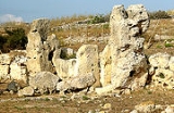
 The remains on the site are a series of megalithic uprights (one of them 3.4m high), the lowest course of the temples' foundations, paving slabs with libation holes in the entrance passage, and the torba
floor of a three-apse temple. This three-apse shape is typical of the Ġgantija phase. Unfortunately, the greater part of the first two apses and the whole of the façade have been razed to ground level.
The north wall is in a better state of preservation. Originally, the entrance of the temple opened on a court, but in later additions during the Tarxien phase, the temple's doorway was closed off, with altars set in the corners formed by the closure. East of this temple, a second monument was added in the Tarxien phase, with four apses and a central niche.
For a period of roughly twelve centuries before the temples were built, a village already stood on the site. Its oldest extant structure is the eleven metre long straight wall to the west of the temples’ first entrance. Deposits at its base contained material from the first known human occupation of the island, the Għar Dalam phase, including charcoal, which carbon analysis dated to 4850 BC.
.
Malta
Malta , officially known as the Republic of Malta , is a Southern European country consisting of an archipelago situated in the centre of the Mediterranean, south of Sicily, east of Tunisia and north of Libya, with Gibraltar to the west and Alexandria to the east.Malta covers just over in...
, which have provided detailed and informative insight into the earliest periods of Malta's neolithic
Neolithic
The Neolithic Age, Era, or Period, or New Stone Age, was a period in the development of human technology, beginning about 9500 BC in some parts of the Middle East, and later in other parts of the world. It is traditionally considered as the last part of the Stone Age...
culture. The site was only excavated in the early sixties, rather late in comparison to other megalithic sites, some of which had been studied since the early nineteenth century. The site's importance has led to its listing as a UNESCO World Heritage Site, a listing it shares with six
other megalithic temples
Megalithic Temples of Malta
The Megalithic Temples of Malta are a series of prehistoric monuments in Malta of which seven are UNESCO World Heritage Sites. Archaeologists believe that these megalithic complexes are the result of local innovations in a process of cultural evolution...
in Malta.
This later excavation allowed the use of modern methods of dating and analysis. The temple itself is not in good condition, especially in comparison to the more complete temples of Ħaġar Qim and Tarxien
Tarxien Temples
The Tarxien Temples are an archaeological complex in Tarxien, Malta. They date back to approximately 2800 BC. The site was accepted as a UNESCO World Heritage Site in 1980 along with the other Megalithic temples on the island of Malta.-Description:...
. However, the importance of this site does not lie in the actual remains but rather in what was garnered from their excavation.
Description
The Żebbiegħ area around Skorba appears to have been inhabited very early in the Neolithic period. When the eminent Maltese historian Sir Temi Żammit excavated the nearby temples of Ta' Ħaġrat, only a single upright slab protruded from a small mound of debris on the Skorba site. Archeologists ignored this mound until David H. Trump excavated it between 1960 and 1963.Torba
Torba as a place may refer to:*Torba, Turkey*Torba Province, Vanuatu*Torba, a village in Măgherani Commune, Mureş County, Romania*Tarbha, Orissa, IndiaTorba may also refer to:...
floor of a three-apse temple. This three-apse shape is typical of the Ġgantija phase. Unfortunately, the greater part of the first two apses and the whole of the façade have been razed to ground level.
The north wall is in a better state of preservation. Originally, the entrance of the temple opened on a court, but in later additions during the Tarxien phase, the temple's doorway was closed off, with altars set in the corners formed by the closure. East of this temple, a second monument was added in the Tarxien phase, with four apses and a central niche.
For a period of roughly twelve centuries before the temples were built, a village already stood on the site. Its oldest extant structure is the eleven metre long straight wall to the west of the temples’ first entrance. Deposits at its base contained material from the first known human occupation of the island, the Għar Dalam phase, including charcoal, which carbon analysis dated to 4850 BC.
Pottery
The pottery found on the site is divided into two categories, the Red Skorba phase and the Grey Skorba phaseGrey Skorba phase
The Grey Skorba phase follows the Early Neolithic Għar Dalam phase in Malta's prehistory. It is marked by a distinctive grey pottery, without decoration. Other remains from the period include seashells, bone ornaments and implements, stone tools and number of sling stones possibly used for hunting...
.