
South Island
Encyclopedia
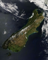
The South Island is the larger of the two major islands of New Zealand
, the other being the more populous North Island
. It is bordered to the north by Cook Strait
, to the west by the Tasman Sea
, to the south and east by the Pacific Ocean
. The territory of the South Island covers 151215 square kilometres (58,384.4 sq mi) and is influenced by a temperate climate.
The South Island is sometimes called the "Mainland". While it has a 33% larger landmass than the North Island
, only % of New Zealand's million inhabitants live in the South Island. In the early stages of European (Pākehā
) settlement of the country, the South Island had the majority of the European population and wealth due to the 1860s gold rush
es. The North Island population overtook the South in the early 20th century, with 56% of the population living in the North in 1911, and the drift north of people and businesses continued throughout the century.
Early inhabitants of the South Island were the Waitaha
. They were largely absorbed via marriage and conquest by the Kāti Mamoe
in the 16th century.
Ngāti Mamoe were in turn largely absorbed via marriage and conquest by the Ngāi Tahu
who migrated south in the 17th century. While today there is no distinct Ngati Mamoe organisation, many Ngai Tahu have Ngati Mamoe links in their whakapapa
and, especially in the far south of the island.
Around the same time a group of Māori migrated to Rekohu (the Chatham Islands
), where, by adapting to the local climate and the availability of resources, they developed a culture known as Moriori
— related to but distinct from Māori culture in mainland New Zealand. A notable feature of the Moriori culture, an emphasis on pacifism
, proved disadvantageous when Māori warrior
s arrived in the 1830s aboard a chartered European ship.
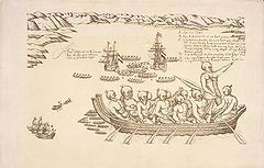
The first Europeans known to reach the South Island were the crew of Dutch
explorer Abel Tasman
who arrived in his ships Heemskerck and Zeehaen. Tasman anchored in Golden Bay
, at the northern end of the island, (he named it Murderers Bay) in December 1642 and sailed northward to Tonga
following a clash with local Māori. Tasman sketched sections of the two main islands' west coasts. Tasman called them Staten Landt, after the States-General of the Netherlands
, and that name appeared on his first maps of the country. Dutch cartographers changed the name to Nova Zeelandia in Latin, from Nieuw Zeeland, after the Dutch province
of Zeeland
. It was subsequently Anglicised as New Zealand by British naval captain James Cook
of HM Bark Endeavour
who visited
the islands more than 100 years after Tasman during (1769–1770).
In the early 18th century, Ngāi Tahu
a Māori tribe who originated on the east coast of the North Island
began migrating to the northern part of the South Island. There they and Kāti Mamoe
fought Ngāi Tara and Rangitāne
in the Wairau Valley
. Ngāti Māmoe then ceded the east coast regions north of the Clarence River
to Ngāi Tahu. Ngāi Tahu continued to push south, conquering Kaikoura
. By the 1730s, Ngāi Tahu had settled in Canterbury
, including Banks Peninsula
. From there they spread further south and into the West Coast
.
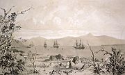
The first European settlement in the South Island was founded at Bluff
in 1823 by James Spencer
a veteran of the Battle of Waterloo
.
In 1827-1828 Ngāti Toa
under the leadership of Te Rauparaha
successfully attacked Ngāi Tahu at Kaikoura. Ngāti Toa then visited Kaiapoi
, ostensibly to trade. When they attacked their hosts, the well-prepared Ngāi Tahu killed all the leading Ngāti Toa chiefs except Te Rauparaha. Te Rauparaha returned to his Kapiti Island
stronghold. In November 1830 Te Rauparaha persuaded Captain John Stewart of the brig Elizabeth to carry him and his warriors in secret to Akaroa
, where by subterfuge they captured the leading Ngāi Tahu chief, Te Maiharanui, and his wife and daughter. After destroying Te Maiharanui's village they took their captives to Kapiti and killed them. John Stewart, though arrested and sent to trial in Sydney as an accomplice to murder, nevertheless escaped conviction.
In the summer of 1831–1832 Te Rauparaha attacked the Kaiapoi pā
(fortified village). After a three-month siege, a fire in the pā allowed Ngāti Toa to overcome it. They then attacked Ngāi Tahu on Banks Peninsula
and took the pā at Onawe
. In 1832-33 Ngāi Tahu retaliated under the leadership of Tuhawaiki
and others, attacking Ngāti Toa at Lake Grassmere
. Ngāi Tahu prevailed, and killed many Ngāti Toa, although Te Rauparaha again escaped. Fighting continued for a year or so, with Ngāi Tahu maintaining the upper hand. Ngāti Toa never again made a major incursion into Ngāi Tahu territory.
By 1839 Ngāi Tahu and Ngāti Toa established peace and Te Rauparaha released the Ngāi Tahu captives he held. Formal marriages between the leading families in the two tribes sealed the peace.
When Britain annexed
New Zealand
in 1840, the South Island briefly became a part of New South Wales
. This annexation was in response to France’s
attempts to colonise the South Island at Akaroa
and the New Zealand Company
attempts to establish a separate colony in Wellington
, and so Lieutenant-Governor William Hobson
declared British sovereignty over all of New Zealand on 21 May 1840 (the North Island by treaty and the South by discovery).
On 17 June 1843, Māori natives and the British settlers clashed at Wairau
in what became known as the Wairau Affray
. Also known as the Wairau Massacre in most older texts, it was the first serious clash of arms between the two parties after the signing of the Treaty of Waitangi
and the only one to take place in the South Island. Four Māori died and three were wounded in the incident, while among the Europeans the toll was 22 dead and five wounded. Twelve of the Europeans were shot dead or clubbed to death after surrendering to Māori who were pursuing them.
While the North Island
was convulsed by the Land Wars
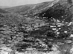
of the 1860s and 1870s, the South Island, with its low Māori population, was generally peaceful. In 1861 gold was discovered at Gabriel's Gully
in Central Otago
, sparking a gold rush
. Dunedin
became the wealthiest city in the country and many in the South Island resented financing the North Island’s wars. In 1865 Parliament voted on a Bill
to make the South Island independent: it was defeated 17 to 31.
In the 1860s, several thousand Chinese
men, mostly from the Guangdong
province, migrated to New Zealand to work on the South Island goldfields. Although the first Chinese migrants had been invited by the Otago
Provincial government they quickly became the target of hostility from white settlers and laws were enacted specifically to discourage them from coming to New Zealand.
Most of the Pākehā population lived in the South Island until around 1900. After that time the North Island regained the lead and has since supported an ever-increasing majority of the country's total population.
er Erima Henare sees Te Wai Pounamu
as the most likely choice. Said to mean "the Water(s) of Greenstone", this possibly evolved from Te Wāhi Pounamu "the Place Of Greenstone". The island is also known as Te Waka a Māui
which means "Māui's Canoe". In Māori legend
, the South Island existed first, as the boat of Maui, while the North Island was the fish that he caught.
In the 19th century, some maps named the South Island as Middle Island or New Munster, and the name South Island or New Leinster
was used for today's Stewart Island/Rakiura
. In 1907 the Minister for Lands gave instructions to the Land and Survey Department that the name Middle Island was not to be used in future. "South Island will be adhered to in all cases".
when used as a noun, whereas maps, headings or tables and adjectival expressions use South Island, similar to the United Kingdom.
 The South Island has no separately represented country subdivision and is guaranteed 16 of the 69 electorates
in the New Zealand House of Representatives
. A two-tier structure constituted under the Local Government Act 2002 gives the South Island seven regional councils
for the administration of regional environmental and transport matters and 25 territorial authorities that administer roads, sewerage, building consents, and other local matters. Four of the territorial councils (one city and three districts) also perform the functions of a regional council
and are known as unitary authorities
.
When New Zealand
was separated from the colony of New South Wales
in 1841 and established as a Crown colony
in its own right, the Royal Charter
effecting this provided that "the principal Islands, heretofore known as, or commonly called, the 'Northern Island', the 'Middle Island', and 'Stewart's Island', shall henceforward be designated and known respectively as 'New Ulster
', 'New Munster', and 'New Leinster
'".
These divisions were at first of geographical significance only, not used as a basis for the government of the colony, which was centralised in Auckland
. New Munster consisted of the South Island and the southern portion of the North Island
, up to the mouth of the Patea River
. The name New Munster was given by the Governor of New Zealand
, Captain William Hobson
, in honour of Munster
, the Irish province in which he was born.
The situation was altered in 1846 when the New Zealand Constitution Act 1846
. divided the colony into two provinces
: New Ulster Province (the North Island), and New Munster Province (the South Island and Stewart Island). Each province had a Governor and Legislative and Executive Council, in addition to the Governor-in-Chief and Legislative and Executive Council for the whole colony. However, the 1846 Constitution Act was later suspended, and only the Provincial government provisions were implemented. Early in 1848 Edward John Eyre
was appointed Lieutenant-Governor of New Munster. In 1851 the Provincial Legislative Councils were permitted to be partially elective.
The Provincial Council of New Munster had only one legislative session, in 1849, before it succumbed to the virulent attacks of settlers from Wellington
. Governor Sir George Grey
, sensible to the pressures, inspired an ordinance of the General Legislative Council under which new Legislative Councils would be established in each province with two-thirds of their members elected on a generous franchise. Grey implemented the ordinance with such deliberation that neither Council met before advice was received that the United Kingdom Parliament had passed the New Zealand Constitution Act 1852
.
This act dissolved these provinces in 1853, after only seven years' existence, and New Munster was divided into the provinces of Canterbury
, Nelson
, and Otago
. Each province had its own legislature known as a Provincial Council that elected its own Speaker and Superintendent.
Secession movements have surfaced several times in the South Island. A Premier of New Zealand
, Sir Julius Vogel
, was amongst the first people to make this call, which was voted on by the Parliament of New Zealand
as early as 1865. The desire for the South Island to form a separate colony was one of the main factors in moving the capital of New Zealand from Auckland
to Wellington
that year.
Several South Island nationalist
groups have emerged over recent years including the South Island Party
with a pro-South agenda, fielded candidates in the 1999 General Election
and a new South Island Party
which was formed before the 2008 General Election
. Today, several internet based groups advocate their support for greater self determination.
On 13 October 2010, South Island Mayors led by Bob Parker of Christchurch displayed united support for a Southern Mayoral Council. Supported by Waitaki
Mayor Alex Familton and Invercargill Mayor Tim Shadbolt
, Bob Parker said that increased cooperation and the forming of a new South Island-wide mayoral forum were essential to representing the island's interests in Wellington and countering the new Auckland Council
.
covering the South Island and all its adjacent islands and territorial waters. Four are governed by an elected regional council
, while three are governed by territorial authorities
(the second tier of local government) which also perform the functions of a regional council
and thus are known as unitary authorities
. There is one exception to this, Nelson City, is governed by an individual Territorial authority to its region (Tasman Region). The Chatham Islands Council is often counted by many as a unitary authority, but it is officially recognised as a part of the region of Canterbury.
, Tasman and the Marlborough
District Councils) also perform the functions of a regional council and thus are known as unitary authorities
.
is the primary law enforcement agency
of New Zealand including the South Island. Three decentralised Police Districts cover the entire South Island with each being commanded by a Superintendent
and having a central station from which subsidiary and suburban stations are managed. The Christchurch Police Communications Centre handles all emergency and general calls within the South Island.
The Tasman Police District covers 70,000 kilometres of territory, encompassing the northern and most of the western portion of the South Island. The West Coast alone spans the distance between Wellington
and Auckland
. There are 22 police stations in the Tasman District, with 6 being sole-charge - or one-person - stations. The Tasman Police District has a total of 302 sworn police officers and 57 civilian or nonsworn staff. Organisationally, the district has its headquarters in Nelson
and has three distinct Areas each headed by an Inspector
as its commander. The areas are Nelson Bays
, West Coast
and Marlborough
.
The Canterbury Police District is based in Christchurch
the largest city in the South Island and covers an area extending from the Conway River
, (just south of Kaikoura
), to the Waitaki River
, south of Timaru
.
The Southern Police District with its headquarters in Dunedin
spans from Oamaru
in the North through to Stewart Island in the far South covers the largest geographical area of any of the 12 police districts in New Zealand.
as part of the South Island Prison Region. Christchurch Prison, also known as Paparua, is located in Templeton
a satellite town of Christchurch
. It accommodates up to 780 minimum, medium and high security male prisoners. It was built in 1925, and also includes a youth unit, a self-care unit and the Paparua Remand Centre (PRC), built in 1999 to replace the old Addington Prison. Christchurch Women's Prison, also located in Templeton
, is a facility for women of all security classifications. It has the only maximum/medium security accommodation for women prisoners in New Zealand. It can accommodate up to 98 prisoners.
Rolleston prison is located in Rolleston
, another satellite town of Christchurch
. It accommodates around 320 male prisoners of minimum to low-medium security classifications and includes Kia Marama a sixty-bed unit that provides an intensive 9 month treatment programme for male child sex offenders. Invercargill Prison, in Invercargill
, accommodates up to 172 minimum to low-medium security prisoners. Otago Corrections Facility is located near Milton
and houses up to 335 minimum to high-medium security male prisoners.
whose role is to provide border control
and protect the community from potential risks arising from international trade
and travel
, as well as collecting duties and tax
es on imports to the country has offices at Christchurch International Airport
, Dunedin
, Invercargill
, Lyttelton
and Nelson
.
Subnational Population Projections: 2006–2031; the South Island's population will increase by an average of 0.6 percent a year to 1,047,100 in 2011, 1,080,900 in 2016, 1,107,900 in 2021, 1,130,900 in 2026 and 1,149,400 in 2031.
† Mosgiel
, an outer suburb of Dunedin, is often regarded as a separate town. It has a population of around 9,000
 The South Island economy is strongly focused on tourism and primary industries like agriculture. The other main industry groups are manufacturing, mining, construction, energy supply, education, health and community services.
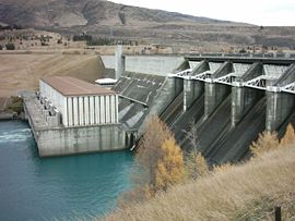
There are three large hydro schemes in the South Island: Waitaki
, Clutha
, and Manapouri
, which combined produce nearly 92% of the island's electricity. The Waitaki River is the largest at 1738 MW of installed capacity. The Waitaki River is the largest hydroelectric scheme, consisting of nine powerhouses commissioned between 1936 and 1985, and generating approximately 7600 GWh annually, around 18% of New Zealand's electricity generation and more than 30% of all its hydroelectricity.
The Clutha River has two major stations generating electricity: Clyde Dam
(432 MW, commissioned 1992) and Roxburgh Dam
(360 MW, commissioned 1962). Manapouri Power Station is an isolated station located in Southland, generating 730 MW of electricity and producing 4800 GWh annually - the largest single hydroelectric power station in the country.
While most of the electricity generated in the South Island is transported via the 220 kV grid (plus 110 kV and 66 kV connectors) to major demand centres, including Christchurch, Dunedin, and Tiwai Point Aluminium Smelter, around one-sixth of it is exported to the North Island to meet its large (and increasing) power demands via the HVDC Inter-Island
link. The 611 km HVDC Inter-Island was commissioned in 1965, linking Benmore Dam
on the Waitaki River in Southern Canterbury
, with Haywards substation in Lower Hutt
in the North island, with cables crossing Cook Strait between Fighting Bay and Oteranga Bay. While the majority of the time the South Island exports electricity to the North Island via the link, it is also used to import thermally-generated North Island electricity in years of low hydro levels.
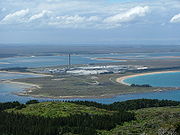
Offshore oil and gas
is likely to become an increasing important part of the South Island economy into the future. Origin Energy
has formed a joint venture with Anadarko Petroleum, the second-largest independent US natural gas producer to begin drilling for oil in the Canterbury Basin off the coast of Dunedin
. The 390 km2, Carrack/Caravel prospect has the potential to deliver more than the equivalent of 500000000 barrels (79,493,647,500 l) of oil and gas. Market analyst, Greg Easton from Craigs Investment Partners commented that such a substantial find it could well turn Dunedin
from the Edinburgh
of the south to the Aberdeen
of the south.
 The Great South Basin
off the coast of Southland
at over 500,000 km2 (covering an area 1.5 times New Zealand’s land mass) is one of New Zealand’s largest undeveloped offshore petroleum basins with prospects for both oil and gas. In July, 2007 the New Zealand Government awarded oil and gas exploration permits for four areas of the Great South Basin, situated in the volatile waters off the Southern Coast of New Zealand. The three successful permit holders are:
The sub-national GDP of the South Island was estimated at US$27.8 billion in 2003, 21% of New Zealand's national GDP.
es of the 1860s, the South Island had regional stock exchanges in Christchurch
, Dunedin
and Invercargill
– all of which were affiliated in the Stock Exchange Association of New Zealand. However, in 1974 these regional exchanges were amalgamated to form one national stock exchange, the New Zealand Stock Exchange (NZSE). Separate trading floors operated in both Christchurch and Dunedin until the late 1980s. On 30 May 2003, New Zealand Stock Exchange Limited formally changed its name to New Zealand Exchange Limited, trading as NZX.
Today, the Deloitte South Island Index is compiled quarterly from publicly available information provided by NZX, Unlisted and Bloomberg. It is a summary of the movements in market capitalisation of each South Island based listed company. A company is included in the Index where either its registered office and/or a substantial portion of its operations are focused on the South Island.
 Tourism is a huge export earner for the South Island. Popular tourist activities in include sightseeing, adventure tourism, tramping (hiking) and camping
. Numerous walking and hiking paths, some of which, like the Milford Track
, have huge international recognition.
An increase in direct international flights to Christchurch
, Dunedin
and Queenstown
has boosted the number of overseas tourists.
Fiordland National Park
, Abel Tasman National Park
, Westland National Park, Aoraki/Mount Cook National Park
, Queenstown
, Kaikoura
and the Marlborough Sounds
are regarded as the main tourism destinations in the South Island and amongst the Top 10 destinations in New Zealand
.
in the South Island.
 .
.
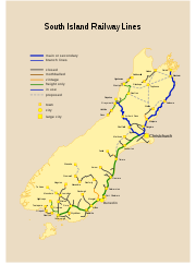
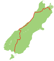
The South Island's railway network has two main lines, two secondary lines, and a few branch line
s. The Main North Line from Picton to Christchurch and the Main South Line
from Lyttelton to Invercargill via Dunedin together comprise the South Island Main Trunk Railway
. The secondary Midland Line
branches from the Main South Line in Rolleston
and passes through the Southern Alps
via the Otira Tunnel
to the West Coast and its terminus in Greymouth
. In Stillwater
, it meets the other secondary route, the Stillwater - Westport Line
, which now includes the Ngakawau Branch
.
A number of other secondary routes are now closed, including the Otago Central Railway, the isolated Nelson Section
, and the interdependent Waimea Plains Railway
and Kingston Branch. An expansive network of branch lines once existed, especially in Canterbury, Otago, and Southland, but these are now almost completely closed. The branch lines that remain in operation serve ports (Bluff Branch
and Port Chalmers Branch
), coal mines (Ohai Branch
and Rapahoe Branch), and a dairying factory (Hokitika Branch). The first 64 km of the Otago Central Railway remain in operation for tourist trains run by the Taieri Gorge Railway
(TGR). The most significant freight is coal from West Coast mines to the port of Lyttelton for export.
Passenger services were once extensive. Commuter trains operated multiple routes around Christchurch and Dunedin, plus a service between Invercargill and Bluff. Due to substantial losses, these were cancelled between the late 1960s and early 1980s. The final services to operate ran between Dunedin and Mosgiel
, and they ceased in 1982. Regional passenger trains were once extensive, but are now limited to the TranzCoastal from Christchurch to Picton and the TranzAlpine
from Christchurch to Greymouth.
The Southerner between Christchurch and Invercargill, once the flagship of the network, was cancelled on 10 February 2002. Subsequently, the architecturally significant Dunedin Railway Station
has been used solely by the TGR's tourist trains, the Taieri Gorge Limited along the Otago Central Railway and the Seasider
to Palmerston
. Rural passenger services on branch lines were provided by mixed train
s and Vulcan
/88 seater
railcar
s but the mixeds had largely ceased to exist by the 1950s and the railcars were withdrawn in the mid-1970s.
The South Island saw the final use of steam locomotive
s in New Zealand. Locomotives belonging to classes long withdrawn elsewhere continued to operate on West Coast branches until the very late 1960s, when they were displaced by DJ class
diesels. In comparison to most countries, where steam locomotives were last used on insubstantial rural and industrial operations, the very last services run by steam locomotives were the premier expresses between Christchurch and Invercargill: the South Island Limited
until 1970 and the Friday and Sunday night services until 1971. This was due to the carriages being steam-heated. The final steam-hauled service in New Zealand, headed by a member of the JA class
, ran on 26 October 1971.
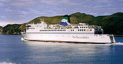 The South Island is separated from the North Island by Cook Strait, 24 km wide at its narrowest point, but requiring a 70 km ferry trip to cross.
Dunedin was the headquarters of the Union Steam Ship Company
, once the largest shipping company in the Southern Hemisphere
.
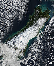
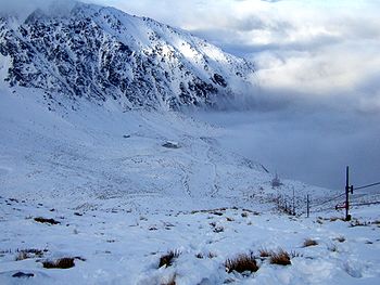
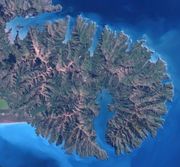
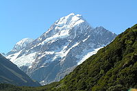 The South Island, with an area of 151215 km² (58,384.4 sq mi), is the largest land mass of New Zealand; it contains about one quarter of the New Zealand population and is the world's 12th-largest island. It is divided along its length by the Southern Alps
, the highest peak of which is Aoraki/Mount Cook
at 3754 metres (12,316 ft). There are eighteen peaks of more than 3000 metres (9800 ft) in the South Island. The east side of the island is home to the Canterbury Plains
while the West Coast
is famous for its rough coastlines, very high proportion of native bush
, and Fox
and Franz Josef Glacier
s. The dramatic landscape of the South Island has made it a popular location for the production of several film
s, including the Lord of the Rings trilogy
and the The Chronicles of Narnia: The Lion, The Witch, and the Wardrobe
.
earthquake
, which caused extensive damage and several power outages. Several major aftershocks were reported.
The February 22nd Christchurch earthquake of 6.3 magnitude caused far more additional damage in Christchurch, resulting 181 deaths. This quake struck at about lunchtime and was centred closer at Lyttleton, and shallower than the prior quake, consequently causing extensive damage.
in the South Island is mostly temperate. The Mean
temperature for the South Island is 8 °C (46 °F). January and February are the warmest months while July is the coldest. Historical maxima and minima
are 42.4 °C (108.3 °F) in Rangiora, Canterbury
and −21.6 °C (−6.9 °F) in Ophir
, Otago
.
Conditions vary sharply across the regions from extremely wet on the West Coast
to semi-arid
in the Mackenzie Basin
of inland Canterbury
. Most areas have between 600 and 1600 mm of rainfall
with the most rain along the West Coast and the least rain on the East Coast, predominantly on the Canterbury Plains
. Christchurch
is the driest city receiving about 640 mm (25 in) of rain per year. The southern and south-western parts of South Island have a cooler and cloudier climate, with around 1400–1600 hours of sunshine
annually; the northern and north-eastern parts of the South Island are the sunniest areas and receive approximately 2400–2500 hours.
 There are six Forest Parks in the South Island which are on public land administered by the Department of Conservation.
Catlins Forest Park : Situated in the Southland
region.
Craigieburn Forest Park
: Situated in the Canterbury region, its boundaries lie in part alongside State Highway 73 and is adjacent to the eastern flanks of the Southern Alps
. The Broken River Ski Area
and the Craigieburn Valley Ski Area lie within its borders. The New Zealand Forest Service
had used the area as an experimental forestry area and there is now an environmental issue with the spread of wilding conifer
s.
Hanmer Forest Park : Situated in the Canterbury region.
Lake Sumner Forest Park
: Situated in the Canterbury region.
Mount Richmond Forest Park : Situated in the Marlborough region.
Victoria Forest Park : Situated in the West Coast region.
 The South Island has ten national parks established under the National Parks Act 1980
and which are administered by the Department of Conservation.
From north to south, the National Parks are:
Kahurangi National Park
: (4,520 km², established 1996) Situated in the north-west of the South Island, Kahurangi comprises spectacular and remote country and includes the Heaphy Track. It has ancient landforms and unique flora and fauna. It is New Zealand's second largest national park.
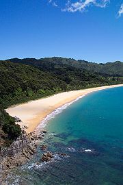
Abel Tasman National Park
: (225 km², established 1942) Has numerous tidal inlets and beaches of golden sand along the shores of Tasman Bay
. It is New Zealand's smallest national park.
Nelson Lakes National Park
: (1,018 km², established 1956) A rugged, mountainous area in Nelson Region. It extends southwards from the forested shores of Lake Rotoiti and Rotoroa to the Lewis Pass National Reserve.
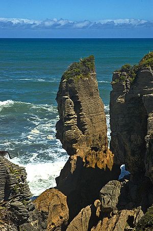
Paparoa National Park
: (306 km², established 1987) On the West Coast of the South Island between Westport
and Greymouth
. It includes the celebrated Pancake Rocks at Punakaiki
.
Arthur's Pass National Park
: (1,144 km², established 1929) A rugged and mountainous area straddling the main divide of the Southern Alps
.
Westland Tai Poutini National Park : (1,175 km², established 1960) Extends from the highest peaks of the Southern Alps to a wild remote coastline. Included in the park are glacier
s, scenic lakes and dense rainforest
, plus remains of old gold mining
towns along the coast.
Aoraki/Mount Cook National Park
: (707 km², established 1953) An alpine park, containing New Zealand's highest mountain, Aoraki/Mount Cook
(3,754 m) and its longest glacier, Tasman Glacier
(29 km). A focus for mountaineering
, ski touring
and scenic flights, the park is an area of outstanding natural beauty. Together, the Mount Cook and Westland National Parks have been declared a World Heritage Site
.
Mount Aspiring National Park
: (3,555 km², established 1964) A complex of impressively glaciated mountain scenery centred on Mount Aspiring/Tititea (3,036 m), New Zealand's highest peak outside of the main divide.
Fiordland National Park
: (12,519 km², established 1952) The largest national park in New Zealand and one of the largest in the world. The grandeur of its scenery, with its deep fiords, its lakes of glacial origin, its mountains and waterfall
s, has earned it international recognition as a world heritage area.
Rakiura National Park
: (1,500 km², established 2002) On Stewart Island/Rakiura
.
Other Native Reserves and Parks
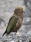
 There are several bird species which are endemic to the South Island. They include the Kea
, Great Spotted Kiwi
, Okarito Brown Kiwi
, South Island Kōkako
, South Island Pied Oystercatcher
, Malherbe's Parakeet
, King Shag
, Takahe
, Black-fronted Tern
, New Zealand Robin
, Rock Wren
, Wrybill
, Yellowhead
Unfortunately many South Island bird species are now extinct, mainly due to predation by cat
s and rat
s introduced by humans. Extinct species include the South Island Goose
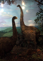
, South Island Giant Moa
and South Island Piopio
.
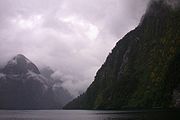 The South Island has 15 named maritime fiords which are all located in the southwest of the island in a mountainous area known as Fiordland
. The spelling 'fiord' is used in New Zealand, although all the maritime fjord
s use the word Sound
in their name instead.
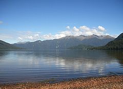
A number of lakes in the Fiordland and Otago
regions also fill glacial valleys. Lake Te Anau
has three western arms which are fjords (and are named so). Lake McKerrow
to the north of Milford Sound
is a fjord with a silted-up mouth. Lake Wakatipu
fills a large glacial valley, as do lakes Hakapoua, Poteriteri
, Monowai
and Hauroko
in the far south of Fiordland. Lake Manapouri
has fjords as its West, North and South arms.
The Marlborough Sounds
, are a series of deep indentations in the coastline at the northern tip of the South Island, are in fact ria
s, drowned river valleys.
 Most of New Zealand's glaciers are in the South Island. They are generally found in the Southern Alps
near the Main Divide.
An inventory of South Island glaciers during the 1980s indicated there were about 3,155 glaciers with an area of at least one hectare (2.5 acres). Approximately one sixth of these glaciers covered more than 10 hectares. These include the Fox
and Franz Josef
glaciers on the West Coast, and the Tasman
, Hooker
, Mueller
and Murchison
glaciers in the east.
 There are some 3,820 lakes in New Zealand
with a surface area
larger than one hectare
. Much of the higher country in the South Island was covered by ice during the glacial period
s of the last two million years. Advancing glaciers eroded large steep-sided valleys, and often carried piles of moraine
(rocks and soil) that acted as natural dams. When the glaciers retreated, they left basins that are now filled by lakes. The level of most glacial lakes in the upper parts of the Waitaki
and Clutha
rivers are controlled for electricity generation. Hydroelectric reservoirs are common in South Canterbury and Central Otago
, the largest of which is Lake Benmore
, on the Waitaki River
.
The South Island has 8 of New Zealand's 10 biggest lakes. They were formed by glaciers and include Lake Wakatipu
, Lake Tekapo
and Lake Manapouri
. The deepest (462 m) is Lake Hauroko
, in western Southland
. It is the 16th deepest lake in the world. Millions of years ago, Central Otago
had a huge lake – Lake Manuherikia. It was slowly filled in with mud, and fossils of fish and crocodiles have been found there.
 There are 4 extinct volcanoes in the South Island, all of which are located on the east coast.
Banks Peninsula
forms the most prominent of these volcanic features. Geologically, the peninsula comprises the eroded remnants of two large shield volcano
es (Lyttelton formed first, then Akaroa). These formed due to intraplate volcanism between approximately eleven and eight million years ago (Miocene
) on a continental crust. The peninsula formed as offshore islands, with the volcanoes reaching to about 1,500 m above sea level. Two dominant craters formed Lyttelton
and Akaroa
Harbours.
The Canterbury Plains
formed from the erosion of the Southern Alps
(an extensive and high mountain range caused by the meeting of the Indo-Australian
and Pacific tectonic plates
) and from the alluvial fan
s created by large braided river
s. These plains reach their widest point where they meet the hilly sub-region of Banks Peninsula. A layer of loess
, a rather unstable fine silt deposited by the foehn winds which bluster across the plains, covers the northern and western flanks of the peninsula. The portion of crater rim lying between Lyttelton Harbour and Christchurch city forms the Port Hills
.
The Otago Harbour
was formed from the drowned remnants of a giant shield volcano
, centred close to what is now the town of Port Chalmers
. The remains of this violent origin can be seen in the basalt
of the surrounding hills. The last eruptive phase ended some ten million years ago, leaving the prominent peak of Mount Cargill
.
Timaru
was constructed on rolling hills created from the lava flows of the extinct Mount Horrible, which last erupted many thousands of years ago.
for "the place of greenstone") is a World Heritage site
in the south west corner of the South Island.
Inscribed on the World Heritage List in 1990 it covers 26,000 km² and incorporates the Aoraki/Mount Cook
, the Fiordland
, the Mount Aspiring
and the Westland
National Parks.
It is thought to contain some of the best modern representations of the original flora
and fauna
present in Gondwanaland,
one of the reasons for listing as a World Heritage site.
 The South Island has several tertiary level institutions:
. Organized around geographical areas of varying population sizes, they are not coterminous with the Local Government Regions
.
and rescue helicopter
services operating throughout the South Island.
 The South Island has contributed to the Arts in New Zealand and internationally through highly regarded artists such as Nigel Brown
, Frances Hodgkins
, Colin McCahon
, Shona McFarlane
, Peter McIntyre
Grahame Sydney
and Geoff Williams
.
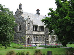
The University of Canterbury
School of Fine Arts was founded in 1950.
South Island Art Galleries include:
and Otago
are famous for its people speaking what is often referred to as the "Southland burr", a semi-rhotic
, Scottish-influenced dialect
of the English language
.
 The South Island has ten daily newspapers and a large number of weekly community newspapers; major daily newspapers include the Ashburton Guardian
, Greymouth Star, The Marlborough Express
, The Nelson Mail
, Oamaru Mail
, Otago Daily Times
, The Press
, Southland Times, The Timaru Herald
, and West Coast Times. The Press and Otago Daily Times, serving mainly Chritchurch and Dunedin respectively, are the South Islands major newspapers.
, Canterbury Television
, CUE, Mainland Television, Shine TV
, and Visitor TV. These stations mainly broadcast free to air on UHF frequencies, however some are carried on subscription TV. Content ranges from local news, access broadcasts, satellite sourced news, tourist information and Christian programming to music videos.
, The Radio Network
, and MediaWorks New Zealand.
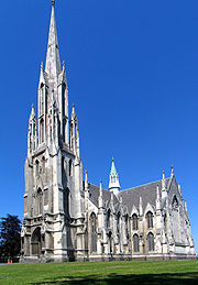
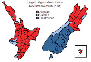 Anglicanism
is strongest in Canterbury
(the city of Christchurch
having been founded as an Anglican settlement).
Catholicism
is still has a noticeably strong presence on the West Coast
, and in Kaikoura
. The territorial authorities with the highest proportion of Catholics are Kaikoura (where they are 18.4% of the total population), Westland
(18.3%), and Grey
(17.8%).
Presbyterianism
is strong in the lower South Island — the city of Dunedin
was founded as a Presbyterian settlement, and many of the early settlers in the region were Scottish Presbyterians. The territorial authorities with the highest proportion of Presbyterians are Gore
(where they are 30.9% of the total population), Clutha District
(30.7%), and Southland
(29.8%).
The first Muslim
s in New Zealand were Chinese gold diggers working in the Dunstan gold fields of Otago
in the 1860s. Dunedin's Al-Huda mosque is the world's southernmost, and the farthest from Mecca
.
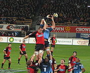 A number of professional sports teams are based in the South Island — with the major spectator sports of rugby union
and cricket
particularly well represented. The Crusaders and Highlanders represent the upper and lower South Island respectively in rugby union's Super Rugby competition; and Canterbury
, Otago, Southland Stags
, Tasman Makos
all participate in provincial rugby's ITM Cup. The South Island is represented by the Canterbury Wizards
, Central Stags, and Otago Volts
in the Plunket Shield, one day domestic series, and the HRV Twenty20 Cup.
As well as rugby union and cricket, the South Island also boasts representative teams in the domestic basketball
, soccer
, ice hockey
, netball
, and rugby league.
The North vs South match
, sometimes known as the Interisland match was a longstanding rugby union fixture in New Zealand. The first game was played in 1897 and the last match was played in 1995.
Christchurch also hosted the 1974 Commonwealth Games. An unidentified group is promoting a bid for the South Island to host the 2022 Winter Olympics
.
New Zealand
New Zealand is an island country in the south-western Pacific Ocean comprising two main landmasses and numerous smaller islands. The country is situated some east of Australia across the Tasman Sea, and roughly south of the Pacific island nations of New Caledonia, Fiji, and Tonga...
, the other being the more populous North Island
North Island
The North Island is one of the two main islands of New Zealand, separated from the much less populous South Island by Cook Strait. The island is in area, making it the world's 14th-largest island...
. It is bordered to the north by Cook Strait
Cook Strait
Cook Strait is the strait between the North and South Islands of New Zealand. It connects the Tasman Sea on the west with the South Pacific Ocean on the east....
, to the west by the Tasman Sea
Tasman Sea
The Tasman Sea is the large body of water between Australia and New Zealand, approximately across. It extends 2,800 km from north to south. It is a south-western segment of the South Pacific Ocean. The sea was named after the Dutch explorer Abel Janszoon Tasman, the first recorded European...
, to the south and east by the Pacific Ocean
Pacific Ocean
The Pacific Ocean is the largest of the Earth's oceanic divisions. It extends from the Arctic in the north to the Southern Ocean in the south, bounded by Asia and Australia in the west, and the Americas in the east.At 165.2 million square kilometres in area, this largest division of the World...
. The territory of the South Island covers 151215 square kilometres (58,384.4 sq mi) and is influenced by a temperate climate.
The South Island is sometimes called the "Mainland". While it has a 33% larger landmass than the North Island
North Island
The North Island is one of the two main islands of New Zealand, separated from the much less populous South Island by Cook Strait. The island is in area, making it the world's 14th-largest island...
, only % of New Zealand's million inhabitants live in the South Island. In the early stages of European (Pākehā
Pakeha
Pākehā is a Māori language word for New Zealanders who are "of European descent". They are mostly descended from British and to a lesser extent Irish settlers of the nineteenth and twentieth centuries, although some Pākehā have Dutch, Scandinavian, German, Yugoslav or other ancestry...
) settlement of the country, the South Island had the majority of the European population and wealth due to the 1860s gold rush
Gold rush
A gold rush is a period of feverish migration of workers to an area that has had a dramatic discovery of gold. Major gold rushes took place in the 19th century in Australia, Brazil, Canada, South Africa, and the United States, while smaller gold rushes took place elsewhere.In the 19th and early...
es. The North Island population overtook the South in the early 20th century, with 56% of the population living in the North in 1911, and the drift north of people and businesses continued throughout the century.
History
Early inhabitants of the South Island were the Waitaha
Waitaha
Waitaha is an early historical Māori iwi . Inhabitants of the South Island of New Zealand, they were largely absorbed via marriage and conquest first by the Kāti Mamoe and then Ngāi Tahu from the 16th century onward....
. They were largely absorbed via marriage and conquest by the Kāti Mamoe
Kati Mamoe
Kāti Mamoe, or Ngāti Mamoe, is an historic Māori iwi. Originally from the Heretaunga area they moved in the 16th century to the South Island which at the time was occupied by Waitaha....
in the 16th century.
Ngāti Mamoe were in turn largely absorbed via marriage and conquest by the Ngāi Tahu
Ngāi Tahu
Ngāi Tahu, or Kāi Tahu, is the principal Māori iwi of the southern region of New Zealand, with the tribal authority, Te Rūnanga o Ngāi Tahu, being based in Christchurch and Invercargill. The iwi combines three groups, Kāi Tahu itself, and Waitaha and Kāti Mamoe who lived in the South Island prior...
who migrated south in the 17th century. While today there is no distinct Ngati Mamoe organisation, many Ngai Tahu have Ngati Mamoe links in their whakapapa
Whakapapa
Whakapapa , or genealogy, is a fundamental principle that permeates the whole of Māori culture. However, it is more than just a genealogical 'device'...
and, especially in the far south of the island.
Around the same time a group of Māori migrated to Rekohu (the Chatham Islands
Chatham Islands
The Chatham Islands are an archipelago and New Zealand territory in the Pacific Ocean consisting of about ten islands within a radius, the largest of which are Chatham Island and Pitt Island. Their name in the indigenous language, Moriori, means Misty Sun...
), where, by adapting to the local climate and the availability of resources, they developed a culture known as Moriori
Moriori
Moriori are the indigenous people of the Chatham Islands , east of the New Zealand archipelago in the Pacific Ocean...
— related to but distinct from Māori culture in mainland New Zealand. A notable feature of the Moriori culture, an emphasis on pacifism
Pacifism
Pacifism is the opposition to war and violence. The term "pacifism" was coined by the French peace campaignerÉmile Arnaud and adopted by other peace activists at the tenth Universal Peace Congress inGlasgow in 1901.- Definition :...
, proved disadvantageous when Māori warrior
Warrior
A warrior is a person skilled in combat or warfare, especially within the context of a tribal or clan-based society that recognizes a separate warrior class.-Warrior classes in tribal culture:...
s arrived in the 1830s aboard a chartered European ship.
The first Europeans known to reach the South Island were the crew of Dutch
Netherlands
The Netherlands is a constituent country of the Kingdom of the Netherlands, located mainly in North-West Europe and with several islands in the Caribbean. Mainland Netherlands borders the North Sea to the north and west, Belgium to the south, and Germany to the east, and shares maritime borders...
explorer Abel Tasman
Abel Tasman
Abel Janszoon Tasman was a Dutch seafarer, explorer, and merchant, best known for his voyages of 1642 and 1644 in the service of the VOC . His was the first known European expedition to reach the islands of Van Diemen's Land and New Zealand and to sight the Fiji islands...
who arrived in his ships Heemskerck and Zeehaen. Tasman anchored in Golden Bay
Golden Bay
Golden Bay lies at the edge of the junction between the Tasman Sea and Cook Strait. It stretches for 45 kilometres from the long sand spit of Farewell Spit in the north to Separation Point in Abel Tasman National Park at its southern extremity...
, at the northern end of the island, (he named it Murderers Bay) in December 1642 and sailed northward to Tonga
Tonga
Tonga, officially the Kingdom of Tonga , is a state and an archipelago in the South Pacific Ocean, comprising 176 islands scattered over of ocean in the South Pacific...
following a clash with local Māori. Tasman sketched sections of the two main islands' west coasts. Tasman called them Staten Landt, after the States-General of the Netherlands
States-General of the Netherlands
The States-General of the Netherlands is the bicameral legislature of the Netherlands, consisting of the Senate and the House of Representatives. The parliament meets in at the Binnenhof in The Hague. The archaic Dutch word "staten" originally related to the feudal classes in which medieval...
, and that name appeared on his first maps of the country. Dutch cartographers changed the name to Nova Zeelandia in Latin, from Nieuw Zeeland, after the Dutch province
Seventeen Provinces
The Seventeen Provinces were a personal union of states in the Low Countries in the 15th century and 16th century, roughly covering the current Netherlands, Belgium, Luxembourg, a good part of the North of France , and a small part of Western Germany.The Seventeen Provinces were originally held by...
of Zeeland
Zeeland
Zeeland , also called Zealand in English, is the westernmost province of the Netherlands. The province, located in the south-west of the country, consists of a number of islands and a strip bordering Belgium. Its capital is Middelburg. With a population of about 380,000, its area is about...
. It was subsequently Anglicised as New Zealand by British naval captain James Cook
James Cook
Captain James Cook, FRS, RN was a British explorer, navigator and cartographer who ultimately rose to the rank of captain in the Royal Navy...
of HM Bark Endeavour
HM Bark Endeavour
HMS Endeavour, also known as HM Bark Endeavour, was a British Royal Navy research vessel commanded by Lieutenant James Cook on his first voyage of discovery, to Australia and New Zealand from 1769 to 1771....
who visited
First voyage of James Cook
The first voyage of James Cook was a combined Royal Navy and Royal Society expedition to the south Pacific ocean aboard HMS Endeavour, from 1768 to 1771...
the islands more than 100 years after Tasman during (1769–1770).
In the early 18th century, Ngāi Tahu
Ngāi Tahu
Ngāi Tahu, or Kāi Tahu, is the principal Māori iwi of the southern region of New Zealand, with the tribal authority, Te Rūnanga o Ngāi Tahu, being based in Christchurch and Invercargill. The iwi combines three groups, Kāi Tahu itself, and Waitaha and Kāti Mamoe who lived in the South Island prior...
a Māori tribe who originated on the east coast of the North Island
North Island
The North Island is one of the two main islands of New Zealand, separated from the much less populous South Island by Cook Strait. The island is in area, making it the world's 14th-largest island...
began migrating to the northern part of the South Island. There they and Kāti Mamoe
Kati Mamoe
Kāti Mamoe, or Ngāti Mamoe, is an historic Māori iwi. Originally from the Heretaunga area they moved in the 16th century to the South Island which at the time was occupied by Waitaha....
fought Ngāi Tara and Rangitāne
Rangitane
For the famous ship see RMS RangitaneRangitāne is a Māori iwi of New Zealand.-External links:* in Te Ara - the Encyclopedia of New Zealand...
in the Wairau Valley
Wairau River
The Wairau River is one of the longest rivers in New Zealand's South Island. It flows for 170 kilometres from the Spenser Mountains , firstly in a northwards direction and then northeast down a long, straight valley in inland Marlborough.The river's lower reaches are noted for the surrounding...
. Ngāti Māmoe then ceded the east coast regions north of the Clarence River
Clarence River, New Zealand
Clarence River is located on South Island of New Zealand. It is 160 kilometres long.For its first 50 kilometres, the river runs in a generally southeastern direction. It then turns northeast, running down a long straight valley between the Inland and Seaward Kaikoura Ranges...
to Ngāi Tahu. Ngāi Tahu continued to push south, conquering Kaikoura
Kaikoura
Kaikoura is a town on the east coast of the South Island of New Zealand. It is located on State Highway 1 180 km north of Christchurch.Kaikoura became the first local authority to reach the Green Globe tourism certification standard....
. By the 1730s, Ngāi Tahu had settled in Canterbury
Canterbury, New Zealand
The New Zealand region of Canterbury is mainly composed of the Canterbury Plains and the surrounding mountains. Its main city, Christchurch, hosts the main office of the Christchurch City Council, the Canterbury Regional Council - called Environment Canterbury - and the University of Canterbury.-...
, including Banks Peninsula
Banks Peninsula
Banks Peninsula is a peninsula of volcanic origin on the east coast of the South Island of New Zealand. It has an area of approximately and encompasses two large harbours and many smaller bays and coves...
. From there they spread further south and into the West Coast
West Coast, New Zealand
The West Coast is one of the administrative regions of New Zealand, located on the west coast of the South Island, and is one of the more remote and most sparsely populated areas of the country. It is made up of three districts: Buller, Grey and Westland...
.
The first European settlement in the South Island was founded at Bluff
Bluff, New Zealand
Bluff is a town and seaport in the Southland region, on the southern coast of the South Island of New Zealand. It is the southern-most town in New Zealand and, despite Slope Point being further to the south, is colloquially used to refer to the southern extremity of the country...
in 1823 by James Spencer
James Spencer
James Matthew Spencer is an English footballer who plays as a goalkeeper for F.C. United of Manchester.-Stockport County:...
a veteran of the Battle of Waterloo
Battle of Waterloo
The Battle of Waterloo was fought on Sunday 18 June 1815 near Waterloo in present-day Belgium, then part of the United Kingdom of the Netherlands...
.
In 1827-1828 Ngāti Toa
Ngati Toa
Ngāti Toa , an iwi , traces its descent from the eponymous ancestor Toarangatira. The Ngāti Toa region extends from Miria-te-kakara at Rangitikei to Wellington, and across Cook Strait to Wairau and Nelson....
under the leadership of Te Rauparaha
Te Rauparaha
Te Rauparaha was a Māori rangatira and war leader of the Ngāti Toa tribe who took a leading part in the Musket Wars. He was influential in the original sale of conquered Rangitane land to the New Zealand Company and was a participant in the Wairau Incident in Marlborough...
successfully attacked Ngāi Tahu at Kaikoura. Ngāti Toa then visited Kaiapoi
Kaiapoi
Kaiapoi is a town in the Canterbury region of the South Island of New Zealand, located close to the mouth of the Waimakariri River, and approximately 17 kilometres north of Christchurch....
, ostensibly to trade. When they attacked their hosts, the well-prepared Ngāi Tahu killed all the leading Ngāti Toa chiefs except Te Rauparaha. Te Rauparaha returned to his Kapiti Island
Kapiti Island
-External links:* , Department of Conservation* * , Nature Coast Enterprise *...
stronghold. In November 1830 Te Rauparaha persuaded Captain John Stewart of the brig Elizabeth to carry him and his warriors in secret to Akaroa
Akaroa
Akaroa is a village on Banks Peninsula in the Canterbury region of the South Island of New Zealand, situated within a harbour of the same name—the name Akaroa is Kāi Tahu Māori for 'Long Harbour'.- Overview :...
, where by subterfuge they captured the leading Ngāi Tahu chief, Te Maiharanui, and his wife and daughter. After destroying Te Maiharanui's village they took their captives to Kapiti and killed them. John Stewart, though arrested and sent to trial in Sydney as an accomplice to murder, nevertheless escaped conviction.
In the summer of 1831–1832 Te Rauparaha attacked the Kaiapoi pā
Pa (Maori)
The word pā can refer to any Māori village or settlement, but in traditional use it referred to hillforts fortified with palisades and defensive terraces and also to fortified villages. They first came into being about 1450. They are located mainly in the North Island north of lake Taupo...
(fortified village). After a three-month siege, a fire in the pā allowed Ngāti Toa to overcome it. They then attacked Ngāi Tahu on Banks Peninsula
Banks Peninsula
Banks Peninsula is a peninsula of volcanic origin on the east coast of the South Island of New Zealand. It has an area of approximately and encompasses two large harbours and many smaller bays and coves...
and took the pā at Onawe
Onawe
The Ōnawe Peninsula is inside Akaroa harbour, on Banks Peninsula in Canterbury, New Zealand.It was the site of a Ngāi Tahu pā captured by Te Rauparaha, chief of the Ngāti Toa in 1831. Up to 1,200 people were killed here, and the land is sacred to Ngāi Tahu so "is deemed to be vested in Te Runanga o...
. In 1832-33 Ngāi Tahu retaliated under the leadership of Tuhawaiki
Tuhawaiki
Tuhawaiki — often known as Hone Tuhawaiki, John Tuhawaiki or Jack Tuhawaiki, or by his nickname of "Bloody Jack" — became a paramount chief of the Ngāi Tahu Māori iwi in the southern part of the South Island of New Zealand...
and others, attacking Ngāti Toa at Lake Grassmere
Lake Grassmere
Lake Grassmere is close to Cook Strait in the northeastern South Island of New Zealand.- Geography :Lake Grassmere, south of Blenheim and south of the mouth of the Awatere River, is a shallow lagoon protected from the open sea by a single barrier beach covered by sand dunes...
. Ngāi Tahu prevailed, and killed many Ngāti Toa, although Te Rauparaha again escaped. Fighting continued for a year or so, with Ngāi Tahu maintaining the upper hand. Ngāti Toa never again made a major incursion into Ngāi Tahu territory.
By 1839 Ngāi Tahu and Ngāti Toa established peace and Te Rauparaha released the Ngāi Tahu captives he held. Formal marriages between the leading families in the two tribes sealed the peace.
When Britain annexed
Annexation
Annexation is the de jure incorporation of some territory into another geo-political entity . Usually, it is implied that the territory and population being annexed is the smaller, more peripheral, and weaker of the two merging entities, barring physical size...
New Zealand
New Zealand
New Zealand is an island country in the south-western Pacific Ocean comprising two main landmasses and numerous smaller islands. The country is situated some east of Australia across the Tasman Sea, and roughly south of the Pacific island nations of New Caledonia, Fiji, and Tonga...
in 1840, the South Island briefly became a part of New South Wales
New South Wales
New South Wales is a state of :Australia, located in the east of the country. It is bordered by Queensland, Victoria and South Australia to the north, south and west respectively. To the east, the state is bordered by the Tasman Sea, which forms part of the Pacific Ocean. New South Wales...
. This annexation was in response to France’s
France
The French Republic , The French Republic , The French Republic , (commonly known as France , is a unitary semi-presidential republic in Western Europe with several overseas territories and islands located on other continents and in the Indian, Pacific, and Atlantic oceans. Metropolitan France...
attempts to colonise the South Island at Akaroa
Akaroa
Akaroa is a village on Banks Peninsula in the Canterbury region of the South Island of New Zealand, situated within a harbour of the same name—the name Akaroa is Kāi Tahu Māori for 'Long Harbour'.- Overview :...
and the New Zealand Company
New Zealand Company
The New Zealand Company originated in London in 1837 as the New Zealand Association with the aim of promoting the "systematic" colonisation of New Zealand. The association, and later the company, intended to follow the colonising principles of Edward Gibbon Wakefield, who envisaged the creation of...
attempts to establish a separate colony in Wellington
Wellington
Wellington is the capital city and third most populous urban area of New Zealand, although it is likely to have surpassed Christchurch due to the exodus following the Canterbury Earthquake. It is at the southwestern tip of the North Island, between Cook Strait and the Rimutaka Range...
, and so Lieutenant-Governor William Hobson
William Hobson
Captain William Hobson RN was the first Governor of New Zealand and co-author of the Treaty of Waitangi.-Early life:...
declared British sovereignty over all of New Zealand on 21 May 1840 (the North Island by treaty and the South by discovery).
On 17 June 1843, Māori natives and the British settlers clashed at Wairau
Wairau
Wairau may refer to:*Wairau River, a river in the Marlborough Region of New Zealand's South Island*Wairau Valley, a valley of the Wairau River in the Marlborough Region*Wairau Valley, Auckland, a suburb of the North Shore...
in what became known as the Wairau Affray
Wairau Affray
In New Zealand history, the Wairau Affray on 17 June 1843 was the first serious clash of arms between Māori and the British settlers after the signing of the Treaty of Waitangi, and the only one to take place in the South Island...
. Also known as the Wairau Massacre in most older texts, it was the first serious clash of arms between the two parties after the signing of the Treaty of Waitangi
Treaty of Waitangi
The Treaty of Waitangi is a treaty first signed on 6 February 1840 by representatives of the British Crown and various Māori chiefs from the North Island of New Zealand....
and the only one to take place in the South Island. Four Māori died and three were wounded in the incident, while among the Europeans the toll was 22 dead and five wounded. Twelve of the Europeans were shot dead or clubbed to death after surrendering to Māori who were pursuing them.
While the North Island
North Island
The North Island is one of the two main islands of New Zealand, separated from the much less populous South Island by Cook Strait. The island is in area, making it the world's 14th-largest island...
was convulsed by the Land Wars
New Zealand land wars
The New Zealand Wars, sometimes called the Land Wars and also once called the Māori Wars, were a series of armed conflicts that took place in New Zealand between 1845 and 1872...
of the 1860s and 1870s, the South Island, with its low Māori population, was generally peaceful. In 1861 gold was discovered at Gabriel's Gully
Gabriel's Gully
Gabriel's Gully is a locality in Otago, New Zealand, three kilometres from Lawrence township and close to the Tuapeka River.The discovery of gold at Gabriel's Gully by Gabriel Read in May 1861 led to the Central Otago goldrush...
in Central Otago
Central Otago
Central Otago is the inland part of the New Zealand region of Otago in the South Island. The area commonly known as Central Otago includes both the Central Otago District and the Queenstown-Lakes District to the west....
, sparking a gold rush
Central Otago Gold Rush
The Central Otago Gold Rush was a gold rush that occurred during the 1860s in Central Otago, New Zealand...
. Dunedin
Dunedin
Dunedin is the second-largest city in the South Island of New Zealand, and the principal city of the Otago Region. It is considered to be one of the four main urban centres of New Zealand for historic, cultural, and geographic reasons. Dunedin was the largest city by territorial land area until...
became the wealthiest city in the country and many in the South Island resented financing the North Island’s wars. In 1865 Parliament voted on a Bill
Bill (proposed law)
A bill is a proposed law under consideration by a legislature. A bill does not become law until it is passed by the legislature and, in most cases, approved by the executive. Once a bill has been enacted into law, it is called an act or a statute....
to make the South Island independent: it was defeated 17 to 31.
In the 1860s, several thousand Chinese
Chinese people
The term Chinese people may refer to any of the following:*People with Han Chinese ethnicity ....
men, mostly from the Guangdong
Guangdong
Guangdong is a province on the South China Sea coast of the People's Republic of China. The province was previously often written with the alternative English name Kwangtung Province...
province, migrated to New Zealand to work on the South Island goldfields. Although the first Chinese migrants had been invited by the Otago
Otago
Otago is a region of New Zealand in the south of the South Island. The region covers an area of approximately making it the country's second largest region. The population of Otago is...
Provincial government they quickly became the target of hostility from white settlers and laws were enacted specifically to discourage them from coming to New Zealand.
Most of the Pākehā population lived in the South Island until around 1900. After that time the North Island regained the lead and has since supported an ever-increasing majority of the country's total population.
Naming and usage
Although the island has been known as the South Island for many years, the New Zealand Geographic Board has found that, along with the North Island, it has no official name. The board intends to make South Island the island's official name, along with an alternative Māori name. Although several Māori names have been used, Maori Language CommissionMaori Language Commission
New Zealand's Māori Language Commission is an autonomous crown entity set up under the Māori Language Act 1987 with the following functions:...
er Erima Henare sees Te Wai Pounamu
Te Wai Pounamu
Te Wai Pounamu is a Māori name for New Zealand's South Island which is also sometimes referred to as Te Waka a Maui , from mythology....
as the most likely choice. Said to mean "the Water(s) of Greenstone", this possibly evolved from Te Wāhi Pounamu "the Place Of Greenstone". The island is also known as Te Waka a Māui
Te Waka a Maui
Te Waka a Māui is a Māori name for the South Island, New Zealand. Some Māori mythology says that it was the vessel which Māui stood on as he hauled up Te Ika-a-Māui ....
which means "Māui's Canoe". In Māori legend
Maui (Maori mythology)
In Māori mythology, Māui is a culture hero famous for his exploits and his trickery.-Māui's birth:The offspring of Tū increased and multiplied and did not know death until the generation of Māui-tikitiki . Māui is the son of Taranga, the wife of Makeatutara...
, the South Island existed first, as the boat of Maui, while the North Island was the fish that he caught.
In the 19th century, some maps named the South Island as Middle Island or New Munster, and the name South Island or New Leinster
New Leinster
New Leinster was a province of New Zealand, consisting of Stewart Island/Rakiura named after the Irish province of Leinster.Governor William Hobson named the North Island New Ulster, the South Island New Munster and Stewart Island/Rakiura New Leinster after the correspondence regions in Ireland in...
was used for today's Stewart Island/Rakiura
Stewart Island/Rakiura
Stewart Island/Rakiura is the third-largest island of New Zealand. It lies south of the South Island, across Foveaux Strait. Its permanent population is slightly over 400 people, most of whom live in the settlement of Oban.- History and naming :...
. In 1907 the Minister for Lands gave instructions to the Land and Survey Department that the name Middle Island was not to be used in future. "South Island will be adhered to in all cases".
'The South Island'
The South Island takes the definite articleDefinite Article
Definite Article is the title of British comedian Eddie Izzard's 1996 performance released on VHS. It was recorded on different nights at the Shaftesbury Theatre...
when used as a noun, whereas maps, headings or tables and adjectival expressions use South Island, similar to the United Kingdom.
Government and politics
New Zealand electorates
An electorate is a voting district for elections to the Parliament of New Zealand. In informal discussion, electorates are often called seats. The most formal description, electoral district, is rarely seen outside of electoral legislation. Before 1996, all Members of Parliament were directly...
in the New Zealand House of Representatives
New Zealand House of Representatives
The New Zealand House of Representatives is the sole chamber of the legislature of New Zealand. The House and the Queen of New Zealand form the New Zealand Parliament....
. A two-tier structure constituted under the Local Government Act 2002 gives the South Island seven regional councils
Regions of New Zealand
The region is the top tier of local government in New Zealand. There are 16 regions of New Zealand. Eleven are governed by an elected regional council, while five are governed by territorial authorities which also perform the functions of a regional council and thus are known as unitary authorities...
for the administration of regional environmental and transport matters and 25 territorial authorities that administer roads, sewerage, building consents, and other local matters. Four of the territorial councils (one city and three districts) also perform the functions of a regional council
Regions of New Zealand
The region is the top tier of local government in New Zealand. There are 16 regions of New Zealand. Eleven are governed by an elected regional council, while five are governed by territorial authorities which also perform the functions of a regional council and thus are known as unitary authorities...
and are known as unitary authorities
Unitary authority
A unitary authority is a type of local authority that has a single tier and is responsible for all local government functions within its area or performs additional functions which elsewhere in the relevant country are usually performed by national government or a higher level of sub-national...
.
When New Zealand
New Zealand
New Zealand is an island country in the south-western Pacific Ocean comprising two main landmasses and numerous smaller islands. The country is situated some east of Australia across the Tasman Sea, and roughly south of the Pacific island nations of New Caledonia, Fiji, and Tonga...
was separated from the colony of New South Wales
New South Wales
New South Wales is a state of :Australia, located in the east of the country. It is bordered by Queensland, Victoria and South Australia to the north, south and west respectively. To the east, the state is bordered by the Tasman Sea, which forms part of the Pacific Ocean. New South Wales...
in 1841 and established as a Crown colony
Crown colony
A Crown colony, also known in the 17th century as royal colony, was a type of colonial administration of the English and later British Empire....
in its own right, the Royal Charter
Royal Charter
A royal charter is a formal document issued by a monarch as letters patent, granting a right or power to an individual or a body corporate. They were, and are still, used to establish significant organizations such as cities or universities. Charters should be distinguished from warrants and...
effecting this provided that "the principal Islands, heretofore known as, or commonly called, the 'Northern Island', the 'Middle Island', and 'Stewart's Island', shall henceforward be designated and known respectively as 'New Ulster
New Ulster
New Ulster was the name of a province of New Zealand that existed between 1841 and 1853.-Original province:Between 1841 and 1846 the province included all the North Island north of the Patea River. With the passing of the New Zealand Constitution Act 1846, the province came to include all of the...
', 'New Munster', and 'New Leinster
New Leinster
New Leinster was a province of New Zealand, consisting of Stewart Island/Rakiura named after the Irish province of Leinster.Governor William Hobson named the North Island New Ulster, the South Island New Munster and Stewart Island/Rakiura New Leinster after the correspondence regions in Ireland in...
'".
These divisions were at first of geographical significance only, not used as a basis for the government of the colony, which was centralised in Auckland
Auckland
The Auckland metropolitan area , in the North Island of New Zealand, is the largest and most populous urban area in the country with residents, percent of the country's population. Auckland also has the largest Polynesian population of any city in the world...
. New Munster consisted of the South Island and the southern portion of the North Island
North Island
The North Island is one of the two main islands of New Zealand, separated from the much less populous South Island by Cook Strait. The island is in area, making it the world's 14th-largest island...
, up to the mouth of the Patea River
Patea River
The Patea River is in Taranaki in the North Island of New Zealand. It runs for 105 kilometres from the eastern slopes of Mount Taranaki, passing east through Stratford before swinging south and reaching the South Taranaki Bight near the town of Patea....
. The name New Munster was given by the Governor of New Zealand
Governor-General of New Zealand
The Governor-General of New Zealand is the representative of the monarch of New Zealand . The Governor-General acts as the Queen's vice-regal representative in New Zealand and is often viewed as the de facto head of state....
, Captain William Hobson
William Hobson
Captain William Hobson RN was the first Governor of New Zealand and co-author of the Treaty of Waitangi.-Early life:...
, in honour of Munster
Munster
Munster is one of the Provinces of Ireland situated in the south of Ireland. In Ancient Ireland, it was one of the fifths ruled by a "king of over-kings" . Following the Norman invasion of Ireland, the ancient kingdoms were shired into a number of counties for administrative and judicial purposes...
, the Irish province in which he was born.
The situation was altered in 1846 when the New Zealand Constitution Act 1846
New Zealand Constitution Act 1846
The New Zealand Constitution Act 1846 was an Act of the Parliament of the United Kingdom intended to grant self-government to the colony of New Zealand, but it was never fully implemented...
. divided the colony into two provinces
Provinces of New Zealand
The Provinces of New Zealand existed from 1841 until 1876 as a form of sub-national government. They were replaced by counties, which were themselves replaced by districts.Following abolition, the provinces became known as provincial districts...
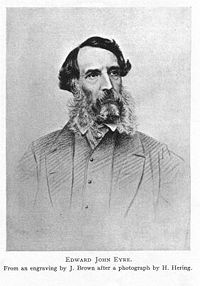
: New Ulster Province (the North Island), and New Munster Province (the South Island and Stewart Island). Each province had a Governor and Legislative and Executive Council, in addition to the Governor-in-Chief and Legislative and Executive Council for the whole colony. However, the 1846 Constitution Act was later suspended, and only the Provincial government provisions were implemented. Early in 1848 Edward John Eyre
Edward John Eyre
Edward John Eyre was an English land explorer of the Australian continent, colonial administrator, and a controversial Governor of Jamaica....
was appointed Lieutenant-Governor of New Munster. In 1851 the Provincial Legislative Councils were permitted to be partially elective.
The Provincial Council of New Munster had only one legislative session, in 1849, before it succumbed to the virulent attacks of settlers from Wellington
Wellington
Wellington is the capital city and third most populous urban area of New Zealand, although it is likely to have surpassed Christchurch due to the exodus following the Canterbury Earthquake. It is at the southwestern tip of the North Island, between Cook Strait and the Rimutaka Range...
. Governor Sir George Grey
George Grey
George Grey may refer to:*Sir George Grey, 2nd Baronet , British politician*George Grey, 2nd Earl of Kent *Sir George Grey , Governor of Cape Colony, South Australia and New Zealand...
, sensible to the pressures, inspired an ordinance of the General Legislative Council under which new Legislative Councils would be established in each province with two-thirds of their members elected on a generous franchise. Grey implemented the ordinance with such deliberation that neither Council met before advice was received that the United Kingdom Parliament had passed the New Zealand Constitution Act 1852
New Zealand Constitution Act 1852
The New Zealand Constitution Act 1852 was an Act of the Parliament of the United Kingdom that granted self-government to the colony of New Zealand...
.
This act dissolved these provinces in 1853, after only seven years' existence, and New Munster was divided into the provinces of Canterbury
Canterbury Province
The Canterbury Province was a province of New Zealand from 1853 until the abolition of provincial government in 1876. On the east coast the province was bounded by the Hurunui River in the north and the Waitaki River in the south...
, Nelson
Nelson Province
The Nelson Province was a province of New Zealand from 1853 until the abolition of provincial government in 1876.-History:The Marlborough Province split away from the Nelson Province on 1 November 1859 because the majority of the income of the Provincial Council came from land sales in the...
, and Otago
Otago Province
The Otago Province was a province of New Zealand until the abolition of provincial government in 1876.-Area:The capital of the province was Dunedin...
. Each province had its own legislature known as a Provincial Council that elected its own Speaker and Superintendent.
Secession movements have surfaced several times in the South Island. A Premier of New Zealand
Prime Minister of New Zealand
The Prime Minister of New Zealand is New Zealand's head of government consequent on being the leader of the party or coalition with majority support in the Parliament of New Zealand...
, Sir Julius Vogel
Julius Vogel
Sir Julius Vogel, KCMG was the eighth Premier of New Zealand. His administration is best remembered for the issuing of bonds to fund railway construction and other public works...
, was amongst the first people to make this call, which was voted on by the Parliament of New Zealand
Parliament of New Zealand
The Parliament of New Zealand consists of the Queen of New Zealand and the New Zealand House of Representatives and, until 1951, the New Zealand Legislative Council. The House of Representatives is often referred to as "Parliament".The House of Representatives usually consists of 120 Members of...
as early as 1865. The desire for the South Island to form a separate colony was one of the main factors in moving the capital of New Zealand from Auckland
Auckland
The Auckland metropolitan area , in the North Island of New Zealand, is the largest and most populous urban area in the country with residents, percent of the country's population. Auckland also has the largest Polynesian population of any city in the world...
to Wellington
Wellington
Wellington is the capital city and third most populous urban area of New Zealand, although it is likely to have surpassed Christchurch due to the exodus following the Canterbury Earthquake. It is at the southwestern tip of the North Island, between Cook Strait and the Rimutaka Range...
that year.
Several South Island nationalist
South Island nationalism
South Island nationalism refers to a nationalist movement in the South Island of New Zealand. This political viewpoint is not widely held - in the 1999 elections the NZ South Island Party received 2,622 votes, 0.14% of the total...
groups have emerged over recent years including the South Island Party
South Island Party
The South Island Party is the name of two unrelated political parties from New Zealand:*The NZ South Island Party stood in the 1999 General Election*The South Island Party stood in the 2008 General Election...
with a pro-South agenda, fielded candidates in the 1999 General Election
New Zealand general election, 1999
The 1999 New Zealand general election was held on 27 November 1999 to determine the composition of the 46th New Zealand Parliament. The governing National Party, led by Prime Minister Jenny Shipley, was defeated, being replaced by a coalition of Helen Clark's Labour Party and the smaller Alliance...
and a new South Island Party
South Island Party (2008)
The South Island Party was a small regionalist political party in New Zealand. It advocated South Island Independence. The party's leader was Richard Prosser, a contributor to Investigate, who had previously called for a regional Parliament for the South Island.The party was founded on the belief...
which was formed before the 2008 General Election
New Zealand general election, 2008
The 2008 New Zealand general election was held on 8 November 2008 to determine the composition of the 49th New Zealand parliament. The conservative National Party, headed by its Parliamentary leader John Key, won a plurality of votes and seats, ending 9 years of government dominated by the social...
. Today, several internet based groups advocate their support for greater self determination.
On 13 October 2010, South Island Mayors led by Bob Parker of Christchurch displayed united support for a Southern Mayoral Council. Supported by Waitaki
Waitaki District
The Waitaki district, in the Canterbury and Otago regions of New Zealand, straddles the traditional border between the two regions, the Waitaki River. It has a land area of 7,151.94 km² , divided 59.28% to Canterbury Region and 40.72% to Otago Region. It is the only district on the South...
Mayor Alex Familton and Invercargill Mayor Tim Shadbolt
Tim Shadbolt
Timothy Richard "Tim" Shadbolt is a New Zealand politician. He is the Mayor of Invercargill and was previously Mayor of Waitemata City.-Early life:...
, Bob Parker said that increased cooperation and the forming of a new South Island-wide mayoral forum were essential to representing the island's interests in Wellington and countering the new Auckland Council
Auckland Council
The Auckland Council is the council for the Auckland Region in New Zealand. It began operating on 1 November 2010, combining the functions of the existing regional council and the region's seven previous city and district councils into one "super council" or "super city" governed by a mayor, 20...
.
Administrative divisions
Local government regions
There are seven local government regionsRegions of New Zealand
The region is the top tier of local government in New Zealand. There are 16 regions of New Zealand. Eleven are governed by an elected regional council, while five are governed by territorial authorities which also perform the functions of a regional council and thus are known as unitary authorities...
covering the South Island and all its adjacent islands and territorial waters. Four are governed by an elected regional council
Regions of New Zealand
The region is the top tier of local government in New Zealand. There are 16 regions of New Zealand. Eleven are governed by an elected regional council, while five are governed by territorial authorities which also perform the functions of a regional council and thus are known as unitary authorities...
, while three are governed by territorial authorities
Territorial authorities of New Zealand
Territorial authorities are the second tier of local government in New Zealand, below regional councils. There are 67 territorial authorities: 13 city councils, 53 district councils, and the Chatham Islands Council...
(the second tier of local government) which also perform the functions of a regional council
Regions of New Zealand
The region is the top tier of local government in New Zealand. There are 16 regions of New Zealand. Eleven are governed by an elected regional council, while five are governed by territorial authorities which also perform the functions of a regional council and thus are known as unitary authorities...
and thus are known as unitary authorities
Unitary authority
A unitary authority is a type of local authority that has a single tier and is responsible for all local government functions within its area or performs additional functions which elsewhere in the relevant country are usually performed by national government or a higher level of sub-national...
. There is one exception to this, Nelson City, is governed by an individual Territorial authority to its region (Tasman Region). The Chatham Islands Council is often counted by many as a unitary authority, but it is officially recognised as a part of the region of Canterbury.
Territorial authorities
There are 23 territorial authorities within the South Island: 4 city councils and 19 district councils. Four territorial authorities (Nelson City CouncilNelson, New Zealand
Nelson is a city on the eastern shores of Tasman Bay, and is the economic and cultural centre of the Nelson-Tasman region. Established in 1841, it is the second oldest settled city in New Zealand and the oldest in the South Island....
, Tasman and the Marlborough
Marlborough, New Zealand
Marlborough is one of the regions of New Zealand, located in the northeast of the South Island. Marlborough is a unitary authority, both a region and a district, and its council is located at Blenheim. Marlborough is known for its dry climate, the picturesque Marlborough Sounds, and sauvignon blanc...
District Councils) also perform the functions of a regional council and thus are known as unitary authorities
Unitary authority
A unitary authority is a type of local authority that has a single tier and is responsible for all local government functions within its area or performs additional functions which elsewhere in the relevant country are usually performed by national government or a higher level of sub-national...
.
| Name | Seat | Area (km2) | Density (per km2) | Region(s) Regions of New Zealand The region is the top tier of local government in New Zealand. There are 16 regions of New Zealand. Eleven are governed by an elected regional council, while five are governed by territorial authorities which also perform the functions of a regional council and thus are known as unitary authorities... |
|
|---|---|---|---|---|---|
| Ashburton District | Ashburton | 6,208 | Canterbury | ||
| Buller District Buller District 200px|rightBuller District, administered by the Buller District Council is an administrative region in the West Coast Region of New Zealand. It covers Westport, Karamea, Reefton and Inangahua Junction. Its land area is 7,953.12 km²... |
Westport Westport, New Zealand -Economy:Economic activity is based around fishing, coal mining and dairy farming. Historically, gold mining was a major industry, and coal mining was much more extensive than today . However, the region still is home to New Zealand's largest opencast mining operation in Stockton... |
7,950 | West Coast | ||
| Central Otago District | Alexandra Alexandra, New Zealand Alexandra is a town in the Central Otago district of the Otago region of New Zealand. It is located on the banks of the Clutha River , on State Highway 8, 188 km by road from Dunedin and 33 km south of Cromwell.At the time of the 2006 census, the permanent population was 4,827, an... |
9,966 | Otago | ||
| Christchurch City Christchurch City Council The Christchurch City Council is the local government authority for Christchurch in New Zealand. It is a territorial authority elected to represent the people of Christchurch. Since 2007, the Mayor of Christchurch is Bob Parker, who stood as an independent candidate... |
Christchurch Christchurch Christchurch is the largest city in the South Island of New Zealand, and the country's second-largest urban area after Auckland. It lies one third of the way down the South Island's east coast, just north of Banks Peninsula which itself, since 2006, lies within the formal limits of... |
1,610 | Canterbury | ||
| Clutha District Clutha District The Clutha District is an administrative district of southern New Zealand, with its headquarters in the Otago town of Balclutha. The Clutha District has a land area of 6,362.86 km² and a 2006 census population of 16,839 usual residents... |
Balclutha Balclutha, New Zealand Balclutha is a town in Otago, it lies towards the end of the Clutha River on the east coast of the South Island of New Zealand. It is about halfway between Dunedin and Invercargill on the Main South Line railway, State Highway 1 and the Southern Scenic Route... |
6,406 | Otago | ||
| Dunedin City Dunedin Dunedin is the second-largest city in the South Island of New Zealand, and the principal city of the Otago Region. It is considered to be one of the four main urban centres of New Zealand for historic, cultural, and geographic reasons. Dunedin was the largest city by territorial land area until... |
Dunedin | 3,340 | Otago | ||
| Gore District | Gore | 1,251 | Southland Southland Region Southland is New Zealand's southernmost region and is also a district within that region. It consists mainly of the southwestern portion of the South Island and Stewart Island / Rakiura... |
||
| Grey District Grey District Grey District Council in the West Coast region of New Zealand is a municipality that covers Greymouth, Runanga, Blackball, Cobden and settlements along the Grey River. It has a land area of 3,516.48 km²... |
Greymouth | 3,516 | West Coast | ||
| Hurunui District Hurunui District The Hurunui District is a political district on the east coast of New Zealand's South Island, north of Christchurch, New Zealand. It forms part of the Canterbury region and stretches from the east coast to the main divide. Its land area is .... |
Amberley Amberley, New Zealand Amberley is a town located in the Hurunui District of north Canterbury, on the east coast of the South Island of New Zealand. It is located on State Highway 1 approximately 50 km north of Christchurch... |
8,661 | Canterbury | ||
| Invercargill City | Invercargill | 491 | Southland Southland Region Southland is New Zealand's southernmost region and is also a district within that region. It consists mainly of the southwestern portion of the South Island and Stewart Island / Rakiura... |
||
| Kaikoura District | Kaikoura | 2,050 | Canterbury | ||
| Mackenzie District Mackenzie District Mackenzie District is a political district in New Zealand's South Island. It is part of the larger Canterbury Region.-Principal settlements:*Fairlie*Twizel*Cave*Mount Cook Village*Albury*TekapoAlso*Burkes Pass-Geography:See Mackenzie Basin,... |
Fairlie | 7,442 | Canterbury | ||
| Marlborough District | Blenheim Blenheim, New Zealand Blenheim is the most populous town in the region of Marlborough, in the north east of the South Island of New Zealand, and the seat of the regional council. It has a population of The area which surrounds the town is well known as a centre of New Zealand's wine industry... |
12,484 | unitary authority Unitary authority A unitary authority is a type of local authority that has a single tier and is responsible for all local government functions within its area or performs additional functions which elsewhere in the relevant country are usually performed by national government or a higher level of sub-national... |
||
| Nelson City Nelson, New Zealand Nelson is a city on the eastern shores of Tasman Bay, and is the economic and cultural centre of the Nelson-Tasman region. Established in 1841, it is the second oldest settled city in New Zealand and the oldest in the South Island.... |
Nelson Nelson, New Zealand Nelson is a city on the eastern shores of Tasman Bay, and is the economic and cultural centre of the Nelson-Tasman region. Established in 1841, it is the second oldest settled city in New Zealand and the oldest in the South Island.... |
445 | unitary authority Unitary authority A unitary authority is a type of local authority that has a single tier and is responsible for all local government functions within its area or performs additional functions which elsewhere in the relevant country are usually performed by national government or a higher level of sub-national... |
||
| Queenstown-Lakes District | Queenstown Queenstown, New Zealand Queenstown is a resort town in Otago in the south-west of New Zealand's South Island. It is built around an inlet called Queenstown Bay on Lake Wakatipu, a long thin Z-shaped lake formed by glacial processes, and has spectacular views of nearby mountains.... |
9,368 | Otago | ||
| Selwyn District Selwyn District The Selwyn District is a predominantly rural area in central Canterbury, on the east coast of New Zealand's South Island. It is named after the Selwyn River, which is in turn named after Bishop George Selwyn, the first Anglican bishop of New Zealand who, in 1843 and 1844, travelled the length of... |
Rolleston Rolleston, New Zealand Rolleston is a town in the Selwyn District of Canterbury, New Zealand.It is located next to State Highway 1, 22 km south-west of Christchurch on the Canterbury Plains in the South Island of New Zealand. The town uses the slogan "The Town of the Future"... |
6,557 | Canterbury | ||
| Southland District Southland District Southland District is a territorial authority in the South Island of New Zealand. Southland District covers the majority of the land area of Southland Region, although the region also covers Gore District, Invercargill City and adjacent territorial waters... |
Invercargill Invercargill Invercargill is the southernmost and westernmost city in New Zealand, and one of the southernmost cities in the world. It is the commercial centre of the Southland region. It lies in the heart of the wide expanse of the Southland Plains on the Oreti or New River some 18 km north of Bluff,... |
32,605 | Southland Southland Region Southland is New Zealand's southernmost region and is also a district within that region. It consists mainly of the southwestern portion of the South Island and Stewart Island / Rakiura... |
||
| Tasman District Tasman district council Tasman District Council is the Territorial Local Authority for the Tasman District of New Zealand.-Mayor:The current mayor of Tasman is Richard Kempthorne, who previously served as a Richmond councillor for two terms before being elected Mayor in October 2007.-Councillors:Tasman elects its... |
Richmond Richmond, New Zealand Richmond, the seat of the Tasman District Council, lies 13 km south of Nelson in the South Island of New Zealand, close to the southern extremity of Tasman Bay... |
9,786 | unitary authority Unitary authority A unitary authority is a type of local authority that has a single tier and is responsible for all local government functions within its area or performs additional functions which elsewhere in the relevant country are usually performed by national government or a higher level of sub-national... |
||
| Timaru District | Timaru | 2,726 | Canterbury | ||
| Waimakariri District Waimakariri District The Waimakariri District is a political district of New Zealand, located in the South Island, on the eastern coast of north Canterbury. It is north of Christchurch and the Waimakariri River and is a part of the greater Canterbury region. The name is Māori for cold river.The district was established... |
Rangiora | 2,216 | Canterbury | ||
| Waimate District | Waimate | 3,577 | Canterbury | ||
| Waitaki District Waitaki District The Waitaki district, in the Canterbury and Otago regions of New Zealand, straddles the traditional border between the two regions, the Waitaki River. It has a land area of 7,151.94 km² , divided 59.28% to Canterbury Region and 40.72% to Otago Region. It is the only district on the South... |
Oamaru Oamaru Oamaru , the largest town in North Otago, in the South Island of New Zealand, is the main town in the Waitaki District. It is 80 kilometres south of Timaru and 120 kilometres north of Dunedin, on the Pacific coast, and State Highway 1 and the railway Main South Line connects it to both... |
7,212 | Canterbury (59.61%) Otago (40.39%) |
||
| Westland District Westland District Westland District is a territorial authority on the west coast of New Zealand's South Island. Its population is - Government :The Westland District is governed by an elected Council, headed by an elected Mayor. The Mayor is elected at large. The current Mayor is Maureen Pugh. Councillors are... |
Hokitika | 11,870 | West Coast |
Political parties
This is a list of Political parties, past and present, who have their headquarters in the South Island.- Aotearoa Legalise Cannabis PartyAotearoa Legalise Cannabis PartyThe Aotearoa Legalise Cannabis Party is a political party in New Zealand. It is dedicated to removing or reducing restrictions on the use of cannabis and similar substances...
- Imperial British Conservative PartyImperial British Conservative PartyThe Imperial British Conservative Party was a farcical political party founded by The Wizard of New Zealand. It was dedicated to the grand traditions of British Imperialism in the face of capitalism, globalisation and the distinct lack of culture in Christchurch, New Zealand.The Imperial British...
- National Democrats PartyNational Democrats PartyThe National Democrats Party was a small right-wing political party in New Zealand, formed in 1999 by Anton Foljambe. It has met with limited success....
- New Munster Party
- New Zealand Democratic PartyNew Zealand Democratic PartyThe New Zealand Democratic Party for Social Credit is a small leftist political party in New Zealand. It is based around the ideas of Social Credit, an economic theory which also attracted some degree of support in Canada and Australia...
- New Zealand Progressive PartyNew Zealand Progressive PartyJim Anderton's Progressive Party , is a New Zealand political party generally somewhat to the left of its ally, the Labour Party....
- South Island PartySouth Island PartyThe South Island Party is the name of two unrelated political parties from New Zealand:*The NZ South Island Party stood in the 1999 General Election*The South Island Party stood in the 2008 General Election...
- South Island Party (2008)South Island Party (2008)The South Island Party was a small regionalist political party in New Zealand. It advocated South Island Independence. The party's leader was Richard Prosser, a contributor to Investigate, who had previously called for a regional Parliament for the South Island.The party was founded on the belief...
Police
The New Zealand PoliceNew Zealand Police
The New Zealand Police is the national police force of New Zealand, responsible for enforcing criminal law, enhancing public safety, maintaining order and keeping the peace throughout New Zealand...
is the primary law enforcement agency
Law enforcement agency
In North American English, a law enforcement agency is a government agency responsible for the enforcement of the laws.Outside North America, such organizations are called police services. In North America, some of these services are called police while others have other names In North American...
of New Zealand including the South Island. Three decentralised Police Districts cover the entire South Island with each being commanded by a Superintendent
Superintendent (police)
Superintendent , often shortened to "super", is a rank in British police services and in most English-speaking Commonwealth nations. In many Commonwealth countries the full version is superintendent of police...
and having a central station from which subsidiary and suburban stations are managed. The Christchurch Police Communications Centre handles all emergency and general calls within the South Island.
The Tasman Police District covers 70,000 kilometres of territory, encompassing the northern and most of the western portion of the South Island. The West Coast alone spans the distance between Wellington
Wellington
Wellington is the capital city and third most populous urban area of New Zealand, although it is likely to have surpassed Christchurch due to the exodus following the Canterbury Earthquake. It is at the southwestern tip of the North Island, between Cook Strait and the Rimutaka Range...
and Auckland
Auckland
The Auckland metropolitan area , in the North Island of New Zealand, is the largest and most populous urban area in the country with residents, percent of the country's population. Auckland also has the largest Polynesian population of any city in the world...
. There are 22 police stations in the Tasman District, with 6 being sole-charge - or one-person - stations. The Tasman Police District has a total of 302 sworn police officers and 57 civilian or nonsworn staff. Organisationally, the district has its headquarters in Nelson
Nelson, New Zealand
Nelson is a city on the eastern shores of Tasman Bay, and is the economic and cultural centre of the Nelson-Tasman region. Established in 1841, it is the second oldest settled city in New Zealand and the oldest in the South Island....
and has three distinct Areas each headed by an Inspector
Inspector
Inspector is both a police rank and an administrative position, both used in a number of contexts. However, it is not an equivalent rank in each police force.- Australia :...
as its commander. The areas are Nelson Bays
Nelson, New Zealand
Nelson is a city on the eastern shores of Tasman Bay, and is the economic and cultural centre of the Nelson-Tasman region. Established in 1841, it is the second oldest settled city in New Zealand and the oldest in the South Island....
, West Coast
West Coast, New Zealand
The West Coast is one of the administrative regions of New Zealand, located on the west coast of the South Island, and is one of the more remote and most sparsely populated areas of the country. It is made up of three districts: Buller, Grey and Westland...
and Marlborough
Marlborough, New Zealand
Marlborough is one of the regions of New Zealand, located in the northeast of the South Island. Marlborough is a unitary authority, both a region and a district, and its council is located at Blenheim. Marlborough is known for its dry climate, the picturesque Marlborough Sounds, and sauvignon blanc...
.
The Canterbury Police District is based in Christchurch
Christchurch
Christchurch is the largest city in the South Island of New Zealand, and the country's second-largest urban area after Auckland. It lies one third of the way down the South Island's east coast, just north of Banks Peninsula which itself, since 2006, lies within the formal limits of...
the largest city in the South Island and covers an area extending from the Conway River
Conway River, New Zealand
The Conway River is part of the traditional boundary between the Canterbury and Marlborough regions in the South Island of New Zealand.It arises in the Amuri Range near Palmer Saddle and runs for thirty kilometres south-east through the Hundalee Hills at the south end of the Seaward Kaikoura...
, (just south of Kaikoura
Kaikoura
Kaikoura is a town on the east coast of the South Island of New Zealand. It is located on State Highway 1 180 km north of Christchurch.Kaikoura became the first local authority to reach the Green Globe tourism certification standard....
), to the Waitaki River
Waitaki River
The Waitaki River is a large river in the South Island of New Zealand, some 110 km long. It is the major river of the Mackenzie Basin.It is a braided river which flows through Lake Benmore, Lake Aviemore and Lake Waitaki. These are ultimately fed by three large glacial lakes, Pukaki, Tekapo,...
, south of Timaru
Timaru
TimaruUrban AreaPopulation:27,200Extent:Former Timaru City CouncilTerritorial AuthorityName:Timaru District CouncilPopulation:42,867 Land area:2,736.54 km² Mayor:Janie AnnearWebsite:...
.
The Southern Police District with its headquarters in Dunedin
Dunedin
Dunedin is the second-largest city in the South Island of New Zealand, and the principal city of the Otago Region. It is considered to be one of the four main urban centres of New Zealand for historic, cultural, and geographic reasons. Dunedin was the largest city by territorial land area until...
spans from Oamaru
Oamaru
Oamaru , the largest town in North Otago, in the South Island of New Zealand, is the main town in the Waitaki District. It is 80 kilometres south of Timaru and 120 kilometres north of Dunedin, on the Pacific coast, and State Highway 1 and the railway Main South Line connects it to both...
in the North through to Stewart Island in the far South covers the largest geographical area of any of the 12 police districts in New Zealand.
Correctional facilities
Correctional facilities in the South Island are operated by the Department of CorrectionsDepartment of Corrections (New Zealand)
The Department of Corrections is a state sector organisation of New Zealand. Its core responsibility is the management of the New Zealand corrections system.New Zealand's Minister of Corrections is the Hon...
as part of the South Island Prison Region. Christchurch Prison, also known as Paparua, is located in Templeton
Templeton, New Zealand
Templeton is a small town on the outskirts of Christchurch but part of the Selwyn District. It lies on State Highway 1. It has been the centre of harness racing in Canterbury with many famous names such as Devine, Nyan, Butt, Jones and Carmichael among its people.Its European history goes to over...
a satellite town of Christchurch
Christchurch
Christchurch is the largest city in the South Island of New Zealand, and the country's second-largest urban area after Auckland. It lies one third of the way down the South Island's east coast, just north of Banks Peninsula which itself, since 2006, lies within the formal limits of...
. It accommodates up to 780 minimum, medium and high security male prisoners. It was built in 1925, and also includes a youth unit, a self-care unit and the Paparua Remand Centre (PRC), built in 1999 to replace the old Addington Prison. Christchurch Women's Prison, also located in Templeton
Templeton, New Zealand
Templeton is a small town on the outskirts of Christchurch but part of the Selwyn District. It lies on State Highway 1. It has been the centre of harness racing in Canterbury with many famous names such as Devine, Nyan, Butt, Jones and Carmichael among its people.Its European history goes to over...
, is a facility for women of all security classifications. It has the only maximum/medium security accommodation for women prisoners in New Zealand. It can accommodate up to 98 prisoners.
Rolleston prison is located in Rolleston
Rolleston, New Zealand
Rolleston is a town in the Selwyn District of Canterbury, New Zealand.It is located next to State Highway 1, 22 km south-west of Christchurch on the Canterbury Plains in the South Island of New Zealand. The town uses the slogan "The Town of the Future"...
, another satellite town of Christchurch
Christchurch
Christchurch is the largest city in the South Island of New Zealand, and the country's second-largest urban area after Auckland. It lies one third of the way down the South Island's east coast, just north of Banks Peninsula which itself, since 2006, lies within the formal limits of...
. It accommodates around 320 male prisoners of minimum to low-medium security classifications and includes Kia Marama a sixty-bed unit that provides an intensive 9 month treatment programme for male child sex offenders. Invercargill Prison, in Invercargill
Invercargill
Invercargill is the southernmost and westernmost city in New Zealand, and one of the southernmost cities in the world. It is the commercial centre of the Southland region. It lies in the heart of the wide expanse of the Southland Plains on the Oreti or New River some 18 km north of Bluff,...
, accommodates up to 172 minimum to low-medium security prisoners. Otago Corrections Facility is located near Milton
Milton, New Zealand
Milton is a town of 2,000 people, located on State Highway 1, 50 kilometres to the south of Dunedin in Otago, New Zealand. It lies on the floodplain of the Tokomairiro River, one branch of which loops past the north and south ends of the town...
and houses up to 335 minimum to high-medium security male prisoners.
Customs Service
The New Zealand Customs ServiceNew Zealand Customs Service
The Customs Service is a state sector organisation of New Zealand whose role is to provide border control and protect the community from potential risks arising from international trade and travel, as well as collecting duties and taxes on imports to the country. New Zealand's Minister of Customs...
whose role is to provide border control
Border control
Border controls are measures used by a country to monitor or regulate its borders.The control of the flow of many people, animals and goods across a border may be controlled by government Customs services. Security is enforced by various kinds of Border Guards and Coast Guards...
and protect the community from potential risks arising from international trade
International trade
International trade is the exchange of capital, goods, and services across international borders or territories. In most countries, such trade represents a significant share of gross domestic product...
and travel
Travel
Travel is the movement of people or objects between relatively distant geographical locations. 'Travel' can also include relatively short stays between successive movements.-Etymology:...
, as well as collecting duties and tax
Tax
To tax is to impose a financial charge or other levy upon a taxpayer by a state or the functional equivalent of a state such that failure to pay is punishable by law. Taxes are also imposed by many subnational entities...
es on imports to the country has offices at Christchurch International Airport
Christchurch International Airport
-Facts & figures:As the gateway for Christchurch and the South Island, Christchurch International Airport is New Zealand’s second largest airport.5,908,077 passengers travelled in and out of Christchurch International Airport from 1 July 2008 to 30 June 2009...
, Dunedin
Dunedin
Dunedin is the second-largest city in the South Island of New Zealand, and the principal city of the Otago Region. It is considered to be one of the four main urban centres of New Zealand for historic, cultural, and geographic reasons. Dunedin was the largest city by territorial land area until...
, Invercargill
Invercargill
Invercargill is the southernmost and westernmost city in New Zealand, and one of the southernmost cities in the world. It is the commercial centre of the Southland region. It lies in the heart of the wide expanse of the Southland Plains on the Oreti or New River some 18 km north of Bluff,...
, Lyttelton
Lyttelton, New Zealand
Lyttelton is a port town on the north shore of Lyttelton Harbour close to Banks Peninsula, a suburb of Christchurch on the eastern coast of the South Island of New Zealand....
and Nelson
Nelson, New Zealand
Nelson is a city on the eastern shores of Tasman Bay, and is the economic and cultural centre of the Nelson-Tasman region. Established in 1841, it is the second oldest settled city in New Zealand and the oldest in the South Island....
.
People
Population
Compared to the more populated and multi-ethnic North Island, the South Island has a smaller, more homogeneous resident population of At the 2001 Census, over 91 percent of people in the South Island said they belong to the European ethnic group, compared with 80.1 percent for all of New Zealand. According to the Statistics New ZealandStatistics New Zealand
Statistics New Zealand is the national statistical office of New Zealand.-Organisation:New Zealand's Minister of Statistics is Maurice Williamson who serves as a member of the New Zealand House of Representatives and holds several other posts within government...
Subnational Population Projections: 2006–2031; the South Island's population will increase by an average of 0.6 percent a year to 1,047,100 in 2011, 1,080,900 in 2016, 1,107,900 in 2021, 1,130,900 in 2026 and 1,149,400 in 2031.
Urbanisation
| Cities and towns of the South Island by population Cities and towns of the South Island by population This is a list of cities and towns in the South Island of New Zealand by the size of their urban area.The populations given in the table below are provisional New Zealand usually resident populations, June 2008 estimates, and refer to the entire main urban area unless otherwise... † |
||||||||
|---|---|---|---|---|---|---|---|---|
| City/Town Cities and towns in the South Island This is a list of Cities and towns in the South Island of New Zealand:- See also :*Cities and towns of the South Island by population... |
Region Regions of New Zealand The region is the top tier of local government in New Zealand. There are 16 regions of New Zealand. Eleven are governed by an elected regional council, while five are governed by territorial authorities which also perform the functions of a regional council and thus are known as unitary authorities... |
Population (2008) Cities and towns in the South Island This is a list of Cities and towns in the South Island of New Zealand:- See also :*Cities and towns of the South Island by population... |
City/Town Cities and towns in the South Island This is a list of Cities and towns in the South Island of New Zealand:- See also :*Cities and towns of the South Island by population... |
Region Regions of New Zealand The region is the top tier of local government in New Zealand. There are 16 regions of New Zealand. Eleven are governed by an elected regional council, while five are governed by territorial authorities which also perform the functions of a regional council and thus are known as unitary authorities... |
Population (2008) Cities and towns in the South Island This is a list of Cities and towns in the South Island of New Zealand:- See also :*Cities and towns of the South Island by population... |
|||
| 1 | Christchurch Christchurch Christchurch is the largest city in the South Island of New Zealand, and the country's second-largest urban area after Auckland. It lies one third of the way down the South Island's east coast, just north of Banks Peninsula which itself, since 2006, lies within the formal limits of... |
Canterbury | 11 | Gore Gore, New Zealand Gore is a town, surrounding borough, and district in the Southland region of the South Island of New Zealand.-Geography:The Gore District has a land area of 1,251.62 km² and a resident population of... |
Southland Southland Region Southland is New Zealand's southernmost region and is also a district within that region. It consists mainly of the southwestern portion of the South Island and Stewart Island / Rakiura... |
|||
| 2 | Dunedin Dunedin Dunedin is the second-largest city in the South Island of New Zealand, and the principal city of the Otago Region. It is considered to be one of the four main urban centres of New Zealand for historic, cultural, and geographic reasons. Dunedin was the largest city by territorial land area until... |
Otago Otago Otago is a region of New Zealand in the south of the South Island. The region covers an area of approximately making it the country's second largest region. The population of Otago is... |
12 | Rangiora Rangiora, New Zealand Rangiora is a rural town in the South Island of New Zealand. It is the largest town in north Canterbury and the seat of the Waimakariri District Council.-Geography:... |
Canterbury | 9,288 | ||
| 3 | Nelson Nelson, New Zealand Nelson is a city on the eastern shores of Tasman Bay, and is the economic and cultural centre of the Nelson-Tasman region. Established in 1841, it is the second oldest settled city in New Zealand and the oldest in the South Island.... |
Nelson Nelson, New Zealand Nelson is a city on the eastern shores of Tasman Bay, and is the economic and cultural centre of the Nelson-Tasman region. Established in 1841, it is the second oldest settled city in New Zealand and the oldest in the South Island.... |
13 | Motueka Motueka The town of Motueka in the South Island of New Zealand lies close to the mouth of the Motueka River, on the western shore of Tasman Bay. It is, after Nelson and Richmond, the third largest centre in the Tasman Region, with a population of 7125... |
Tasman | 7,125 | ||
| 4 | Invercargill | Southland Southland Region Southland is New Zealand's southernmost region and is also a district within that region. It consists mainly of the southwestern portion of the South Island and Stewart Island / Rakiura... |
14 | Alexandra Alexandra, New Zealand Alexandra is a town in the Central Otago district of the Otago region of New Zealand. It is located on the banks of the Clutha River , on State Highway 8, 188 km by road from Dunedin and 33 km south of Cromwell.At the time of the 2006 census, the permanent population was 4,827, an... |
Otago Otago Otago is a region of New Zealand in the south of the South Island. The region covers an area of approximately making it the country's second largest region. The population of Otago is... |
5,920 | ||
| 5 | Blenheim Blenheim, New Zealand Blenheim is the most populous town in the region of Marlborough, in the north east of the South Island of New Zealand, and the seat of the regional council. It has a population of The area which surrounds the town is well known as a centre of New Zealand's wine industry... |
Marlborough | 15 | Wanaka Wanaka Wanaka is a town in the Otago region of the South Island of New Zealand. It is situated at the southern end of Lake Wanaka, adjacent to the outflow of the lake to the Clutha River. It is the gateway to Mount Aspiring National Park. Wanaka is primarily a resort town but has both summer and winter... |
Otago Otago Otago is a region of New Zealand in the south of the South Island. The region covers an area of approximately making it the country's second largest region. The population of Otago is... |
5,037 | ||
| 6 | Timaru | Canterbury | 16 | Cromwell Cromwell, New Zealand Cromwell is a town in Central Otago in the Otago region of New Zealand.It is situated between State Highway 6 and State Highway 8 leading to the Lindis Pass, 75 km northeast, and Alexandra, 33 km south. The road to Alexandra winds through the Cromwell Gorge... |
Otago Otago Otago is a region of New Zealand in the south of the South Island. The region covers an area of approximately making it the country's second largest region. The population of Otago is... |
4,080 | ||
| 7 | Ashburton Ashburton, New Zealand Ashburton is a town and district in the Canterbury Region on the east coast of the South Island of New Zealand. It is the third-largest centre in Canterbury, after Christchurch and Timaru. The area around Ashburton is frequently referred to as Mid Canterbury, which is also the name of the... |
Canterbury | 17 | Balclutha Balclutha, New Zealand Balclutha is a town in Otago, it lies towards the end of the Clutha River on the east coast of the South Island of New Zealand. It is about halfway between Dunedin and Invercargill on the Main South Line railway, State Highway 1 and the Southern Scenic Route... |
Otago Otago Otago is a region of New Zealand in the south of the South Island. The region covers an area of approximately making it the country's second largest region. The population of Otago is... |
~4,000 | ||
| 8 | Oamaru Oamaru Oamaru , the largest town in North Otago, in the South Island of New Zealand, is the main town in the Waitaki District. It is 80 kilometres south of Timaru and 120 kilometres north of Dunedin, on the Pacific coast, and State Highway 1 and the railway Main South Line connects it to both... |
Otago Otago Otago is a region of New Zealand in the south of the South Island. The region covers an area of approximately making it the country's second largest region. The population of Otago is... |
18 | Temuka Temuka Temuka is a town on New Zealand's Canterbury Plains, 15 kilometres north of Timaru and 142 km south of Christchurch. It is located at the centre of a rich sheep and dairy farming region, for which it is a service town.-History:... |
Canterbury | 3,981 | ||
| 9 | Queenstown Queenstown, New Zealand Queenstown is a resort town in Otago in the south-west of New Zealand's South Island. It is built around an inlet called Queenstown Bay on Lake Wakatipu, a long thin Z-shaped lake formed by glacial processes, and has spectacular views of nearby mountains.... |
Otago Otago Otago is a region of New Zealand in the south of the South Island. The region covers an area of approximately making it the country's second largest region. The population of Otago is... |
10,442 | 19 | Westport Westport, New Zealand -Economy:Economic activity is based around fishing, coal mining and dairy farming. Historically, gold mining was a major industry, and coal mining was much more extensive than today . However, the region still is home to New Zealand's largest opencast mining operation in Stockton... |
West Coast | ~3,900 | |
| 10 | Greymouth | West Coast | 20 | Rolleston Rolleston, New Zealand Rolleston is a town in the Selwyn District of Canterbury, New Zealand.It is located next to State Highway 1, 22 km south-west of Christchurch on the Canterbury Plains in the South Island of New Zealand. The town uses the slogan "The Town of the Future"... |
Canterbury | 3,822 | ||
† Mosgiel
Mosgiel
Mosgiel is an urban satellite of Dunedin in Otago, New Zealand, fifteen kilometres west of the city's centre. Since the re-organisation of New Zealand local government in 1989 it has been inside the Dunedin City Council area, but was physically separate from the contiguous suburbs until...
, an outer suburb of Dunedin, is often regarded as a separate town. It has a population of around 9,000
Economy
Energy
The South Island is a major centre for electricity generation, especially in the southern half of the island and especially from hydroelectricity. In 2010, the island generated 18,010 GWh of electricity, 41.5% of New Zealand's total electricity generation. Nearly all (98.7%) of the island's electricity is generated by hydroelectricity, with most of the remainder coming from wind generation.There are three large hydro schemes in the South Island: Waitaki
Waitaki River
The Waitaki River is a large river in the South Island of New Zealand, some 110 km long. It is the major river of the Mackenzie Basin.It is a braided river which flows through Lake Benmore, Lake Aviemore and Lake Waitaki. These are ultimately fed by three large glacial lakes, Pukaki, Tekapo,...
, Clutha
Clutha River
The Clutha River / Mata-Au is the second longest river in New Zealand flowing south-southeast through Central and South Otago from Lake Wanaka in the Southern Alps to the Pacific Ocean, south west of Dunedin. It is the highest volume river in New Zealand, and the swiftest, with a catchment of ,...
, and Manapouri
Manapouri Power Station
Manapouri Power Station is an underground hydroelectric power station on the western arm of Lake Manapouri in Fiordland National Park, in the South Island of New Zealand...
, which combined produce nearly 92% of the island's electricity. The Waitaki River is the largest at 1738 MW of installed capacity. The Waitaki River is the largest hydroelectric scheme, consisting of nine powerhouses commissioned between 1936 and 1985, and generating approximately 7600 GWh annually, around 18% of New Zealand's electricity generation and more than 30% of all its hydroelectricity.
The Clutha River has two major stations generating electricity: Clyde Dam
Clyde Dam
The Clyde Dam, New Zealand's third largest hydroelectric dam, is built on the Clutha River near the town of Clyde. It is owned and operated by Contact Energy.-History:...
(432 MW, commissioned 1992) and Roxburgh Dam
Roxburgh Dam
The Roxburgh Dam is the earliest of the large hydroelectric projects in the southern South Island of New Zealand. It lies across the Clutha River / Mata-Au, some from Dunedin, some to the north of the town of Roxburgh...
(360 MW, commissioned 1962). Manapouri Power Station is an isolated station located in Southland, generating 730 MW of electricity and producing 4800 GWh annually - the largest single hydroelectric power station in the country.
While most of the electricity generated in the South Island is transported via the 220 kV grid (plus 110 kV and 66 kV connectors) to major demand centres, including Christchurch, Dunedin, and Tiwai Point Aluminium Smelter, around one-sixth of it is exported to the North Island to meet its large (and increasing) power demands via the HVDC Inter-Island
HVDC Inter-Island
The HVDC Inter-Island link is a high-capacity, bipolar high-voltage direct current transmission system connecting the electricity transmission networks of New Zealand's two main islands to form the National Grid. The HVDC link is owned and operated by state-owned transmission company Transpower...
link. The 611 km HVDC Inter-Island was commissioned in 1965, linking Benmore Dam
Benmore Dam
Benmore Dam is the largest dam within the Waitaki power scheme, located in the Canterbury Region of New Zealand's South Island. There are eight other power stations in the valley....
on the Waitaki River in Southern Canterbury
Canterbury, New Zealand
The New Zealand region of Canterbury is mainly composed of the Canterbury Plains and the surrounding mountains. Its main city, Christchurch, hosts the main office of the Christchurch City Council, the Canterbury Regional Council - called Environment Canterbury - and the University of Canterbury.-...
, with Haywards substation in Lower Hutt
Lower Hutt
Lower Hutt is a city in the Wellington region of New Zealand. Its council has adopted the name Hutt City Council, but neither the New Zealand Geographic Board nor the Local Government Act recognise the name Hutt City. This alternative name can lead to confusion, as there are two cities in the...
in the North island, with cables crossing Cook Strait between Fighting Bay and Oteranga Bay. While the majority of the time the South Island exports electricity to the North Island via the link, it is also used to import thermally-generated North Island electricity in years of low hydro levels.
Offshore oil and gas
Offshore drilling
Offshore drilling refers to a mechanical process where a wellbore is drilled through the seabed. It is typically carried out in order to explore for and subsequently produce hydrocarbons which lie in rock formations beneath the seabed...
is likely to become an increasing important part of the South Island economy into the future. Origin Energy
Origin Energy
-History:Origin Energy was formed in February 2000, as a result of a demerger from the Australian conglomerate Boral Limited, in which the energy business was removed from the building and construction materials business to form the new company....
has formed a joint venture with Anadarko Petroleum, the second-largest independent US natural gas producer to begin drilling for oil in the Canterbury Basin off the coast of Dunedin
Dunedin
Dunedin is the second-largest city in the South Island of New Zealand, and the principal city of the Otago Region. It is considered to be one of the four main urban centres of New Zealand for historic, cultural, and geographic reasons. Dunedin was the largest city by territorial land area until...
. The 390 km2, Carrack/Caravel prospect has the potential to deliver more than the equivalent of 500000000 barrels (79,493,647,500 l) of oil and gas. Market analyst, Greg Easton from Craigs Investment Partners commented that such a substantial find it could well turn Dunedin
Dunedin
Dunedin is the second-largest city in the South Island of New Zealand, and the principal city of the Otago Region. It is considered to be one of the four main urban centres of New Zealand for historic, cultural, and geographic reasons. Dunedin was the largest city by territorial land area until...
from the Edinburgh
Edinburgh
Edinburgh is the capital city of Scotland, the second largest city in Scotland, and the eighth most populous in the United Kingdom. The City of Edinburgh Council governs one of Scotland's 32 local government council areas. The council area includes urban Edinburgh and a rural area...
of the south to the Aberdeen
Aberdeen
Aberdeen is Scotland's third most populous city, one of Scotland's 32 local government council areas and the United Kingdom's 25th most populous city, with an official population estimate of ....
of the south.
Great South Basin
The Great South Basin is an area of mainly sea to the south of the South Island of New Zealand.Starting in the 1960s, the area was explored and drilled for oil deposits by various minerals companies, mostly international, but by 1984 all of these companies had left empty-handed...
off the coast of Southland
Southland Region
Southland is New Zealand's southernmost region and is also a district within that region. It consists mainly of the southwestern portion of the South Island and Stewart Island / Rakiura...
at over 500,000 km2 (covering an area 1.5 times New Zealand’s land mass) is one of New Zealand’s largest undeveloped offshore petroleum basins with prospects for both oil and gas. In July, 2007 the New Zealand Government awarded oil and gas exploration permits for four areas of the Great South Basin, situated in the volatile waters off the Southern Coast of New Zealand. The three successful permit holders are:
- a consortium led by ExxonMobilExxonMobilExxon Mobil Corporation or ExxonMobil, is an American multinational oil and gas corporation. It is a direct descendant of John D. Rockefeller's Standard Oil company, and was formed on November 30, 1999, by the merger of Exxon and Mobil. Its headquarters are in Irving, Texas...
New Zealand (Exploration) Limited (USA) which includes local company Todd Exploration LimitedTodd EnergyTodd Energy is a diversified energy company operating in New Zealand. Todd Energy employs over 200 people and is part of the Todd Corporation. Nova Energy is the retail division of Todd Energy- Electricity :...
(New Zealand); - a consortium led by OMVOMVOMV is Austria's largest oil-producing, refining and gas station operating company with important activities in other Central European countries...
New Zealand Limited (AustriaAustriaAustria , officially the Republic of Austria , is a landlocked country of roughly 8.4 million people in Central Europe. It is bordered by the Czech Republic and Germany to the north, Slovakia and Hungary to the east, Slovenia and Italy to the south, and Switzerland and Liechtenstein to the...
) which includes PTTEP Offshore Investment Company LtdPTT Public Company LimitedPTT Public Company Limited, PTT PCL, or simply PTT is a Thai state-owned SET-listed oil and gas company. Formerly known as the Petroleum Authority of Thailand, it owns extensive submarine gas pipelines in the Gulf of Thailand, a network of LPG terminals throughout the Kingdom, and is involved in...
(ThailandThailandThailand , officially the Kingdom of Thailand , formerly known as Siam , is a country located at the centre of the Indochina peninsula and Southeast Asia. It is bordered to the north by Burma and Laos, to the east by Laos and Cambodia, to the south by the Gulf of Thailand and Malaysia, and to the...
), MitsuiMitsuiis one of the largest corporate conglomerates in Japan and one of the largest publicly traded companies in the world.-History:Founded by Mitsui Takatoshi , who was the fourth son of a shopkeeper in Matsusaka, in what is now today's Mie prefecture...
Exploration and Production Australia Pty Ltd (JapanJapanJapan is an island nation in East Asia. Located in the Pacific Ocean, it lies to the east of the Sea of Japan, China, North Korea, South Korea and Russia, stretching from the Sea of Okhotsk in the north to the East China Sea and Taiwan in the south...
); and - Greymouth PetroleumGreymouth PetroleumGreymouth Petroleum is an energy company in New Zealand, established 2000. It owns gas and oil fields.-External links:*...
Limited (New Zealand)
The sub-national GDP of the South Island was estimated at US$27.8 billion in 2003, 21% of New Zealand's national GDP.
Stock exchanges
Due to the gold rushGold rush
A gold rush is a period of feverish migration of workers to an area that has had a dramatic discovery of gold. Major gold rushes took place in the 19th century in Australia, Brazil, Canada, South Africa, and the United States, while smaller gold rushes took place elsewhere.In the 19th and early...
es of the 1860s, the South Island had regional stock exchanges in Christchurch
Christchurch
Christchurch is the largest city in the South Island of New Zealand, and the country's second-largest urban area after Auckland. It lies one third of the way down the South Island's east coast, just north of Banks Peninsula which itself, since 2006, lies within the formal limits of...
, Dunedin
Dunedin
Dunedin is the second-largest city in the South Island of New Zealand, and the principal city of the Otago Region. It is considered to be one of the four main urban centres of New Zealand for historic, cultural, and geographic reasons. Dunedin was the largest city by territorial land area until...
and Invercargill
Invercargill
Invercargill is the southernmost and westernmost city in New Zealand, and one of the southernmost cities in the world. It is the commercial centre of the Southland region. It lies in the heart of the wide expanse of the Southland Plains on the Oreti or New River some 18 km north of Bluff,...
– all of which were affiliated in the Stock Exchange Association of New Zealand. However, in 1974 these regional exchanges were amalgamated to form one national stock exchange, the New Zealand Stock Exchange (NZSE). Separate trading floors operated in both Christchurch and Dunedin until the late 1980s. On 30 May 2003, New Zealand Stock Exchange Limited formally changed its name to New Zealand Exchange Limited, trading as NZX.
Today, the Deloitte South Island Index is compiled quarterly from publicly available information provided by NZX, Unlisted and Bloomberg. It is a summary of the movements in market capitalisation of each South Island based listed company. A company is included in the Index where either its registered office and/or a substantial portion of its operations are focused on the South Island.
Trade unions
There are several South Island based trade union organisations. They are:- Furniture, Manufacturing & Associated Workers UnionFurniture, Manufacturing & Associated Workers UnionThe Furniture, Manufacturing & Associated Workers Union is a trade union in New Zealand. It has a membership of 620, and is affiliated with the New Zealand Council of Trade Unions.-External links:* at the NZCTU....
- New Zealand Building Trades UnionNew Zealand Building Trades UnionThe New Zealand Building Trades Union is a national trade union in New Zealand. It traces its roots back to a carpenters and joiners union in 1860.The NZBTU has 1400 members and is a member of the New Zealand Council of Trade Unions....
- New Zealand Meat & Related Trades Workers UnionNew Zealand Meat & Related Trades Workers UnionThe New Zealand Meat & Related Trades Workers Union is a trade union in New Zealand. It represents workers in the New Zealand meat industry. This includes workers in Freezing works, Tanneries, Fertiliser plants, halal slaughtermen, small meat processing plants and small goods.The NZ Meat Workers...
- Southern Amalgamated Workers' UnionSouthern Amalgamated Workers' UnionThe Southern Amalgamated Workers' Union is a trade union in New Zealand. It is one of three autonomous unions, with the Northern Amalgamated Workers' Union, and the Central Amalgamated Workers' Union, who operate nationally as the Amalgamated Workers' Union.The AWUNZ is a member of the New Zealand...
Tourism
Camping
Camping is an outdoor recreational activity. The participants leave urban areas, their home region, or civilization and enjoy nature while spending one or several nights outdoors, usually at a campsite. Camping may involve the use of a tent, caravan, motorhome, cabin, a primitive structure, or no...
. Numerous walking and hiking paths, some of which, like the Milford Track
Milford Track
The Milford Track is a widely known tramping route in New Zealand – located amidst mountains and temperate rain forest in Fiordland National Park in the southwest of the South Island....
, have huge international recognition.
An increase in direct international flights to Christchurch
Christchurch
Christchurch is the largest city in the South Island of New Zealand, and the country's second-largest urban area after Auckland. It lies one third of the way down the South Island's east coast, just north of Banks Peninsula which itself, since 2006, lies within the formal limits of...
, Dunedin
Dunedin
Dunedin is the second-largest city in the South Island of New Zealand, and the principal city of the Otago Region. It is considered to be one of the four main urban centres of New Zealand for historic, cultural, and geographic reasons. Dunedin was the largest city by territorial land area until...
and Queenstown
Queenstown, New Zealand
Queenstown is a resort town in Otago in the south-west of New Zealand's South Island. It is built around an inlet called Queenstown Bay on Lake Wakatipu, a long thin Z-shaped lake formed by glacial processes, and has spectacular views of nearby mountains....
has boosted the number of overseas tourists.
Fiordland National Park
Fiordland National Park
Fiordland National Park occupies the southwest corner of the South Island of New Zealand. It is the largest of the 14 national parks in New Zealand, with an area of 12,500 km², and a major part of the Te Wahipounamu World Heritage site...
, Abel Tasman National Park
Abel Tasman National Park
Abel Tasman National Park is a national park located at the north end of the South Island of New Zealand. The park was founded in 1942, largely through the efforts of ornithologist and author Perrine Moncrieff to have land reserved for the purpose. With a coverage of only 225.3 square kilometres,...
, Westland National Park, Aoraki/Mount Cook National Park
Aoraki/Mount Cook National Park
Aoraki/Mount Cook National Park is in the South Island of New Zealand near the town of Twizel. Aoraki/Mount Cook, New Zealand's highest mountain and Aoraki/Mount Cook village lie within the park...
, Queenstown
Queenstown, New Zealand
Queenstown is a resort town in Otago in the south-west of New Zealand's South Island. It is built around an inlet called Queenstown Bay on Lake Wakatipu, a long thin Z-shaped lake formed by glacial processes, and has spectacular views of nearby mountains....
, Kaikoura
Kaikoura
Kaikoura is a town on the east coast of the South Island of New Zealand. It is located on State Highway 1 180 km north of Christchurch.Kaikoura became the first local authority to reach the Green Globe tourism certification standard....
and the Marlborough Sounds
Marlborough Sounds
The Marlborough Sounds are an extensive network of sea-drowned valleys created by a combination of land subsidence and rising sea levels at the north of the South Island of New Zealand...
are regarded as the main tourism destinations in the South Island and amongst the Top 10 destinations in New Zealand
New Zealand
New Zealand is an island country in the south-western Pacific Ocean comprising two main landmasses and numerous smaller islands. The country is situated some east of Australia across the Tasman Sea, and roughly south of the Pacific island nations of New Caledonia, Fiji, and Tonga...
.
Ski areas and resorts
This is a list of ski areas and resortsSki resort
A ski resort is a resort developed for skiing and other winter sports. In Europe a ski resort is a town or village in a ski area - a mountainous area, where there are ski trails and supporting services such as hotels and other accommodation, restaurants, equipment rental and a ski lift system...
in the South Island.
| Name | Location | Notes |
|---|---|---|
| Awakino ski area Awakino ski area The Awakino ski field is located in St. Marys Range, North Otago, New Zealand near Kurow. It is run by the Waitaki Ski Club and is virtually unknown outside of Otago. Awakino best represents skiing as it first began in New Zealand, and the field is little changed from the when it was established in... |
Otago Otago Otago is a region of New Zealand in the south of the South Island. The region covers an area of approximately making it the country's second largest region. The population of Otago is... |
Club Skifield |
| Broken River Broken River, New Zealand Broken River is a river in the South Island of New Zealand. It drains into the Waimakariri River due north of the town of Springfield.The Broken River Ski Area is in the catchment area of the river. The Broken River Cave is on Cave Stream, a tributary of Broken River.-See also:*Rivers in New Zealand... |
Canterbury Canterbury, New Zealand The New Zealand region of Canterbury is mainly composed of the Canterbury Plains and the surrounding mountains. Its main city, Christchurch, hosts the main office of the Christchurch City Council, the Canterbury Regional Council - called Environment Canterbury - and the University of Canterbury.-... |
Club Skifield |
| Cardrona Alpine Resort Cardrona Alpine Resort Cardrona Alpine Resort is a ski resort in New Zealand's South Island. The skifield ranges from 1,260m to 1,894m. The distribution of slopes is 25% beginner, 50% intermediate and 25% advanced. There are 2 detachable quad chairlifts and 2 fixed-grip quad chairlift, 2 "magic carpet" learner lifts and... |
Otago Otago Otago is a region of New Zealand in the south of the South Island. The region covers an area of approximately making it the country's second largest region. The population of Otago is... |
|
| Coronet Peak Coronet Peak Coronet Peak is a commercial skifield in Otago, New Zealand located 18 kilometres to the northeast of the town of Queenstown and seven kilometres west of Arrowtown, on the southern slopes of the 1,649 metre peak which shares its name... |
Otago Otago Otago is a region of New Zealand in the south of the South Island. The region covers an area of approximately making it the country's second largest region. The population of Otago is... |
|
| Craigieburn Valley Craigieburn Valley Craigieburn Valley Ski Area is a club skifield in the Southern Alps of New Zealand's South Island, about east 104km from Christchurch. Catering only to intermediate and advanced skiers, it features a vertical range of 1308—1811 m, 600 hectares of skiable area and 3 fast rope tows. The resort has... |
Canterbury Canterbury, New Zealand The New Zealand region of Canterbury is mainly composed of the Canterbury Plains and the surrounding mountains. Its main city, Christchurch, hosts the main office of the Christchurch City Council, the Canterbury Regional Council - called Environment Canterbury - and the University of Canterbury.-... |
Club Skifield |
| Fox Peak Fox Peak Fox Peak is a small club skifield located 16 kilometres to the east of Lake Tekapo in New Zealand's South Island, New Zealand. Run by a non-profit organisation, the resort features 4 ski tows and a total vertical range of 580 m.-External links:... |
Canterbury Canterbury, New Zealand The New Zealand region of Canterbury is mainly composed of the Canterbury Plains and the surrounding mountains. Its main city, Christchurch, hosts the main office of the Christchurch City Council, the Canterbury Regional Council - called Environment Canterbury - and the University of Canterbury.-... |
Club Skifield |
| Hanmer Springs Ski Area Hanmer Springs Ski Area Hanmer Springs Ski Area, located on Mount Saint Patrick, South Island, New Zealand is a club skifield about 40 minutes' drive from the town of Hanmer Springs. It has one poma lift, and two rope tows, giving access to trails rated as 10% beginner, 50% intermediate and 40% advanced.-References:*... |
Canterbury Canterbury, New Zealand The New Zealand region of Canterbury is mainly composed of the Canterbury Plains and the surrounding mountains. Its main city, Christchurch, hosts the main office of the Christchurch City Council, the Canterbury Regional Council - called Environment Canterbury - and the University of Canterbury.-... |
Club Skifield |
| Invincible Snowfields Invincible Snowfields Invincible Snowfields is a private ski resort near Glenorchy in the South Island of New Zealand.The area is about one hour's drive west of Queenstown and is close to Lake Wakatipu... |
Otago Otago Otago is a region of New Zealand in the south of the South Island. The region covers an area of approximately making it the country's second largest region. The population of Otago is... |
Helicopter access only |
| Mount Cheeseman Mount Cheeseman Mount Cheeseman is a club snowfield in New Zealand's South Island, near the town of Springfield, about an hour and a half from Christchurch. Situated in a south-east-facing basin, it features two T-bar lifts and one learner tow. The runs cover an elevation range of 1570-1840 metres, with a... |
Canterbury Canterbury, New Zealand The New Zealand region of Canterbury is mainly composed of the Canterbury Plains and the surrounding mountains. Its main city, Christchurch, hosts the main office of the Christchurch City Council, the Canterbury Regional Council - called Environment Canterbury - and the University of Canterbury.-... |
Club Skifield |
| Mount Dobson | Canterbury Canterbury, New Zealand The New Zealand region of Canterbury is mainly composed of the Canterbury Plains and the surrounding mountains. Its main city, Christchurch, hosts the main office of the Christchurch City Council, the Canterbury Regional Council - called Environment Canterbury - and the University of Canterbury.-... |
|
| Mount Hutt Mount Hutt, New Zealand Mount Hutt rises to the west of the Canterbury Plains in the South Island of New Zealand, above the braided upper reaches of the Rakaia River, and 80 kilometres west of Christchurch... |
Canterbury Canterbury, New Zealand The New Zealand region of Canterbury is mainly composed of the Canterbury Plains and the surrounding mountains. Its main city, Christchurch, hosts the main office of the Christchurch City Council, the Canterbury Regional Council - called Environment Canterbury - and the University of Canterbury.-... |
|
| Mount Olympus | Canterbury Canterbury, New Zealand The New Zealand region of Canterbury is mainly composed of the Canterbury Plains and the surrounding mountains. Its main city, Christchurch, hosts the main office of the Christchurch City Council, the Canterbury Regional Council - called Environment Canterbury - and the University of Canterbury.-... |
Club Skifield |
| Mount Potts Mount Potts Mount Potts is a specialist backcountry skiing base in South Island, New Zealand. Unlike normal resorts, there are no fixed ski tows or chairlifts. Instead, vertical transport is provided by snowcats and helicopter... |
Canterbury Canterbury, New Zealand The New Zealand region of Canterbury is mainly composed of the Canterbury Plains and the surrounding mountains. Its main city, Christchurch, hosts the main office of the Christchurch City Council, the Canterbury Regional Council - called Environment Canterbury - and the University of Canterbury.-... |
Heliskiing Heliskiing Heliskiing is off-trail, downhill skiing that is accessed by a helicopter, not a ski lift. Heliskiing is essentially about skiing in a natural—albeit highly selected—environment without the effort or gear compromise required for hiking into these areas as in ski touring or ski mountaineering.Most... and snowcatting only |
| Mount Robert Mount Robert Mount Robert 1421m high mountain, in the Nelson area of New Zealand's South Island. It is within the Nelson Lakes National Park.Access to the mountain is via the town of Saint Arnaud on a partially unsealed road followed by a two hour walk.... |
Tasman | Club Skifield |
| Ohau Ohau (skifield) Ohau is a small commercial skifield in the foothills of New Zealand's Southern Alps, near the boundary between the Otago and Canterbury regions, and close to the southwestern shore of the lake of the same name.- Details :... |
Canterbury Canterbury, New Zealand The New Zealand region of Canterbury is mainly composed of the Canterbury Plains and the surrounding mountains. Its main city, Christchurch, hosts the main office of the Christchurch City Council, the Canterbury Regional Council - called Environment Canterbury - and the University of Canterbury.-... |
|
| Porter Ski Area | Canterbury Canterbury, New Zealand The New Zealand region of Canterbury is mainly composed of the Canterbury Plains and the surrounding mountains. Its main city, Christchurch, hosts the main office of the Christchurch City Council, the Canterbury Regional Council - called Environment Canterbury - and the University of Canterbury.-... |
|
| Rainbow | Tasman | |
| The Remarkables The Remarkables, New Zealand The Remarkables are a mountain range and skifield in Otago, South Island of New Zealand. Located on the southeastern shore of Lake Wakatipu, the range lives up to its name by rising sharply to create an impressive backdrop for the waters... |
Otago Otago Otago is a region of New Zealand in the south of the South Island. The region covers an area of approximately making it the country's second largest region. The population of Otago is... |
|
| Round Hill | Canterbury Canterbury, New Zealand The New Zealand region of Canterbury is mainly composed of the Canterbury Plains and the surrounding mountains. Its main city, Christchurch, hosts the main office of the Christchurch City Council, the Canterbury Regional Council - called Environment Canterbury - and the University of Canterbury.-... |
|
| Snow Farm Snow Farm, New Zealand Snow Farm is a ski area near Wanaka, New Zealand, dedicated to cross-country skiing. It features 55 km of trails, and the conference centre has accommodation for about 60 people. It is located on the Pisa range close to Cardrona, at an altitude of 1,515 m, 55 km from Queenstown and... |
Otago Otago Otago is a region of New Zealand in the south of the South Island. The region covers an area of approximately making it the country's second largest region. The population of Otago is... |
cross-country skiing Cross-country skiing Cross-country skiing is a winter sport in which participants propel themselves across snow-covered terrain using skis and poles... |
| Snow Park Snow Park, New Zealand Snow Park is a dedicated snowsports terrain park in South Island, New Zealand. Describing itself as the "first dedicated freestyle terrain park in the world" when it opened in 2002, it features a number of half-pipes, jumps and rails, instead of traditional ski runs.On-mountain accommodation has... |
Otago Otago Otago is a region of New Zealand in the south of the South Island. The region covers an area of approximately making it the country's second largest region. The population of Otago is... |
|
| Tasman Glacier Tasman Glacier The Tasman Glacier is the largest of several glaciers which flow south and east towards the Mackenzie Basin from the Southern Alps in New Zealand's South Island. It is New Zealand's longest glacier.-Geography:... |
Canterbury Canterbury, New Zealand The New Zealand region of Canterbury is mainly composed of the Canterbury Plains and the surrounding mountains. Its main city, Christchurch, hosts the main office of the Christchurch City Council, the Canterbury Regional Council - called Environment Canterbury - and the University of Canterbury.-... |
Heliskiing Heliskiing Heliskiing is off-trail, downhill skiing that is accessed by a helicopter, not a ski lift. Heliskiing is essentially about skiing in a natural—albeit highly selected—environment without the effort or gear compromise required for hiking into these areas as in ski touring or ski mountaineering.Most... |
| Temple Basin | Canterbury Canterbury, New Zealand The New Zealand region of Canterbury is mainly composed of the Canterbury Plains and the surrounding mountains. Its main city, Christchurch, hosts the main office of the Christchurch City Council, the Canterbury Regional Council - called Environment Canterbury - and the University of Canterbury.-... |
Club Skifield |
| Treble Cone Treble Cone Treble Cone is a commercial skifield near Wanaka, New Zealand.Treble Cone boasts the longest vertical rise in the Southern Lakes and spectacular views over Lake Wanaka and Mount Aspiring/Tititea... |
Otago Otago Otago is a region of New Zealand in the south of the South Island. The region covers an area of approximately making it the country's second largest region. The population of Otago is... |
Transport
Road transport
The South Island has a State Highway network of 4,921 km.Rail transport
- See also: List of New Zealand railway lines, Rail transport in New ZealandRail transport in New ZealandRail transport in New Zealand consists of a network of gauge railway lines in both the North and South Islands. Rail services are focused primarily on freight, particularly bulk freight, with limited passenger services on some lines...
.
The South Island's railway network has two main lines, two secondary lines, and a few branch line
Branch line
A branch line is a secondary railway line which branches off a more important through route, usually a main line. A very short branch line may be called a spur line...
s. The Main North Line from Picton to Christchurch and the Main South Line
Main South Line
The Main South Line, sometimes referred to as part of the South Island Main Trunk Railway, is a railroad line that runs north and south from Lyttelton in New Zealand through Christchurch and along the east coast of the South Island to Invercargill via Dunedin...
from Lyttelton to Invercargill via Dunedin together comprise the South Island Main Trunk Railway
South Island Main Trunk Railway
The Main North Line between Picton and Christchurch and the Main South Line between Lyttelton and Invercargill, running down the east coast of the South Island of New Zealand, are sometimes together referred to as the South Island Main Trunk Railway...
. The secondary Midland Line
Midland Line, New Zealand
The Midland line is a 212 km section of railway between Rolleston and Greymouth in the South Island of New Zealand. The line features five major bridges, five viaducts and 17 tunnels, the longest of which is the Otira tunnel.-Freight services:...
branches from the Main South Line in Rolleston
Rolleston, New Zealand
Rolleston is a town in the Selwyn District of Canterbury, New Zealand.It is located next to State Highway 1, 22 km south-west of Christchurch on the Canterbury Plains in the South Island of New Zealand. The town uses the slogan "The Town of the Future"...
and passes through the Southern Alps
Southern Alps
The Southern Alps is a mountain range extending along much of the length of New Zealand's South Island, reaching its greatest elevations near the island's western side...
via the Otira Tunnel
Otira Tunnel
The Otira Tunnel is a railway tunnel on the Midland Line in the South Island of New Zealand between Otira and Arthur's Pass. It runs under the Southern Alps from Arthur's Pass to Otira - a length of over . The gradient is mainly 1 in 33, and the Otira end of the tunnel is over lower than the...
to the West Coast and its terminus in Greymouth
Greymouth
Greymouth is the largest town in the West Coast region in the South Island of New Zealand, and the seat of the Grey District Council. The population of the whole Grey District is , which accounts for % of the West Coast's inhabitants...
. In Stillwater
Stillwater, West Coast
Stillwater is a town in the South Island of New Zealand east of Greymouth on the banks of the Grey River in the Grey District of the West Coast, next to Brunner. There is also Stillwater, Auckland in the North Island....
, it meets the other secondary route, the Stillwater - Westport Line
Stillwater - Westport Line
The Stillwater Ngakawau Line , formerly the Stillwater - Westport Line and the Ngakawau Branch, is a secondary main line, part of New Zealand's national rail network. It runs between Stillwater and Ngakawau via Westport on the West Coast of the South Island...
, which now includes the Ngakawau Branch
Seddonville Branch
The Seddonville Branch, now truncated and operating as the Ngakawau Branch, is a branch line railway in the West Coast region of New Zealand's South Island. Construction of the line began in 1874 and it reached its final terminus at the Mokihinui Mine just beyond Seddonville in 1895...
.
A number of other secondary routes are now closed, including the Otago Central Railway, the isolated Nelson Section
Nelson Section
The Nelson Section was an isolated, gauge, government-owned railway line between Nelson and Glenhope in the Tasman district of New Zealand's South Island. It operated for years between 1876 and 1955...
, and the interdependent Waimea Plains Railway
Waimea Plains Railway
The Waimea Plains Railway was a secondary railway line that linked the towns of Lumsden and Gore in northern Southland, New Zealand...
and Kingston Branch. An expansive network of branch lines once existed, especially in Canterbury, Otago, and Southland, but these are now almost completely closed. The branch lines that remain in operation serve ports (Bluff Branch
Bluff Branch
The Bluff Branch is a railway line in Southland, New Zealand that links Invercargill with the port of Bluff. One of the first railways in New Zealand, it opened in 1867 and is still operating...
and Port Chalmers Branch
Port Chalmers Branch
The Port Chalmers Branch was the first railway line built in Otago, New Zealand, and linked the region's major city of Dunedin with the port in Port Chalmers...
), coal mines (Ohai Branch
Wairio Branch
The Wairio Branch, now incorporating the Ohai Industrial Line, is a branch line railway in Southland, New Zealand. It opened in 1882 and is the sole remaining branch line in Southland, and one of only a few in the entire country...
and Rapahoe Branch), and a dairying factory (Hokitika Branch). The first 64 km of the Otago Central Railway remain in operation for tourist trains run by the Taieri Gorge Railway
Taieri Gorge Railway
The Taieri Gorge Railway is a railway line and tourist train operation based at Dunedin Railway Station in the South Island of New Zealand...
(TGR). The most significant freight is coal from West Coast mines to the port of Lyttelton for export.
Passenger services were once extensive. Commuter trains operated multiple routes around Christchurch and Dunedin, plus a service between Invercargill and Bluff. Due to substantial losses, these were cancelled between the late 1960s and early 1980s. The final services to operate ran between Dunedin and Mosgiel
Mosgiel
Mosgiel is an urban satellite of Dunedin in Otago, New Zealand, fifteen kilometres west of the city's centre. Since the re-organisation of New Zealand local government in 1989 it has been inside the Dunedin City Council area, but was physically separate from the contiguous suburbs until...
, and they ceased in 1982. Regional passenger trains were once extensive, but are now limited to the TranzCoastal from Christchurch to Picton and the TranzAlpine
TranzAlpine
The TranzAlpine Express is a passenger train operated by Tranz Scenic in the South Island of New Zealand. This trip is often regarded to be one of the world's great train journeys for the scenery through which it passes . The journey is one-way, taking about four and a half hours...
from Christchurch to Greymouth.
The Southerner between Christchurch and Invercargill, once the flagship of the network, was cancelled on 10 February 2002. Subsequently, the architecturally significant Dunedin Railway Station
Dunedin Railway Station
Possibly the best-known building in the southern half of New Zealand's South Island, Dunedin Railway Station is a jewel in the country's architectural crown. Designed by George Troup, the station is the fourth building to have served as Dunedin's railway station...
has been used solely by the TGR's tourist trains, the Taieri Gorge Limited along the Otago Central Railway and the Seasider
Seasider (train)
The Seasider is a tourist train in the South Island of New Zealand, operated by the Taieri Gorge Railway along the Main South Line between the historic Dunedin Railway Station and Palmerston once or twice a week in the summer months and occasionally during winter. Since the demise of the...
to Palmerston
Palmerston, New Zealand
The town of Palmerston, in New Zealand's South Island lies 50 kilometres to the north of the city of Dunedin. It is the largest town in the Waihemo Ward of the Waitaki District with a population of 890 residents...
. Rural passenger services on branch lines were provided by mixed train
Mixed train
A mixed train is a train that hauls both passenger and freight cars or wagons. In the early days of railways they were quite common, but by the 20th century they were largely confined to branch lines with little traffic. As the trains provided passengers with very slow service, mixed trains have...
s and Vulcan
NZR RM class (Vulcan)
The NZR RM class Vulcan railcars were operated by the New Zealand Railways Department in the South Island of New Zealand. All New Zealand railcars were classified as RM, and these were known as Vulcan railcars, from the name of the manufacturer, Vulcan Foundry of Britain. - Background :On 9 May...
/88 seater
NZR RM class (88 seater)
The NZR RM class 88-seaters were a class of railcar used in New Zealand, known unofficially as 'articulateds', 'twinsets', 'Drewrys' and 'Fiats'. They were purchased to replace steam-hauled provincial passenger trains and mixed trains...
railcar
Railcar
A railcar, in British English and Australian English, is a self-propelled railway vehicle designed to transport passengers. The term "railcar" is usually used in reference to a train consisting of a single coach , with a driver's cab at one or both ends. Some railways, e.g., the Great Western...
s but the mixeds had largely ceased to exist by the 1950s and the railcars were withdrawn in the mid-1970s.
The South Island saw the final use of steam locomotive
Steam locomotive
A steam locomotive is a railway locomotive that produces its power through a steam engine. These locomotives are fueled by burning some combustible material, usually coal, wood or oil, to produce steam in a boiler, which drives the steam engine...
s in New Zealand. Locomotives belonging to classes long withdrawn elsewhere continued to operate on West Coast branches until the very late 1960s, when they were displaced by DJ class
NZR DJ class
The NZR DJ class locomotive is a class of diesel-electric locomotive used in New Zealand. The class were purchased from Mitsubishi Heavy Industries with a modernisation loan from the World Bank to replace steam locomotives in the South Island, where most of the class members worked most of their...
diesels. In comparison to most countries, where steam locomotives were last used on insubstantial rural and industrial operations, the very last services run by steam locomotives were the premier expresses between Christchurch and Invercargill: the South Island Limited
South Island Limited
The South Island Limited was a passenger express train operated by the New Zealand Railways Department between 1949 and 1970. It operated between Christchurch and Invercargill via Dunedin, and in its heyday, it was New Zealand's premier express....
until 1970 and the Friday and Sunday night services until 1971. This was due to the carriages being steam-heated. The final steam-hauled service in New Zealand, headed by a member of the JA class
NZR Ja class
The NZR JA class were a type of 4-8-2 steam locomotive used on the New Zealand railway network. The class was built in two batches, with the second batch possessing some differences from the first...
, ran on 26 October 1971.
Water transport
Dunedin was the headquarters of the Union Steam Ship Company
Union Company
The Union Company, Union Steam Ship Company , or Union Line was started in Dunedin, New Zealand, in 1875, when it was floated by James Mills, who had been clerk to Johnny Jones and his Harbour Steam Company....
, once the largest shipping company in the Southern Hemisphere
Southern Hemisphere
The Southern Hemisphere is the part of Earth that lies south of the equator. The word hemisphere literally means 'half ball' or "half sphere"...
.
Ports and harbours
- Container ports: LytteltonLyttelton, New ZealandLyttelton is a port town on the north shore of Lyttelton Harbour close to Banks Peninsula, a suburb of Christchurch on the eastern coast of the South Island of New Zealand....
(ChristchurchChristchurchChristchurch is the largest city in the South Island of New Zealand, and the country's second-largest urban area after Auckland. It lies one third of the way down the South Island's east coast, just north of Banks Peninsula which itself, since 2006, lies within the formal limits of...
), Port ChalmersPort ChalmersPort Chalmers is a suburb and the main port of the city of Dunedin, New Zealand, with a population of 3,000. Port Chalmers lies ten kilometres inside Otago Harbour, some 15 kilometres northeast from Dunedin's city centre....
(DunedinDunedinDunedin is the second-largest city in the South Island of New Zealand, and the principal city of the Otago Region. It is considered to be one of the four main urban centres of New Zealand for historic, cultural, and geographic reasons. Dunedin was the largest city by territorial land area until...
) - Other ports: NelsonNelson, New ZealandNelson is a city on the eastern shores of Tasman Bay, and is the economic and cultural centre of the Nelson-Tasman region. Established in 1841, it is the second oldest settled city in New Zealand and the oldest in the South Island....
, PictonPicton, New ZealandPicton is a town in the Marlborough region of New Zealand. It is close to the head of Queen Charlotte Sound near the north-east corner of the South Island. The population was 2928 in the 2006 Census, a decrease of 72 from 2001...
, WestportWestport, New Zealand-Economy:Economic activity is based around fishing, coal mining and dairy farming. Historically, gold mining was a major industry, and coal mining was much more extensive than today . However, the region still is home to New Zealand's largest opencast mining operation in Stockton...
, GreymouthGreymouthGreymouth is the largest town in the West Coast region in the South Island of New Zealand, and the seat of the Grey District Council. The population of the whole Grey District is , which accounts for % of the West Coast's inhabitants...
, TimaruTimaruTimaruUrban AreaPopulation:27,200Extent:Former Timaru City CouncilTerritorial AuthorityName:Timaru District CouncilPopulation:42,867 Land area:2,736.54 km² Mayor:Janie AnnearWebsite:...
, BluffBluff, New ZealandBluff is a town and seaport in the Southland region, on the southern coast of the South Island of New Zealand. It is the southern-most town in New Zealand and, despite Slope Point being further to the south, is colloquially used to refer to the southern extremity of the country...
. - Harbours: AkaroaAkaroaAkaroa is a village on Banks Peninsula in the Canterbury region of the South Island of New Zealand, situated within a harbour of the same name—the name Akaroa is Kāi Tahu Māori for 'Long Harbour'.- Overview :...
, Otago HarbourOtago HarbourOtago Harbour is the natural harbour of Dunedin, New Zealand, consisting of a long, much-indented stretch of generally navigable water separating the Otago Peninsula from the mainland. They join at its southwest end, from the harbour mouth...
, Halfmoon Bay (Stewart Island/RakiuraStewart Island/RakiuraStewart Island/Rakiura is the third-largest island of New Zealand. It lies south of the South Island, across Foveaux Strait. Its permanent population is slightly over 400 people, most of whom live in the settlement of Oban.- History and naming :...
), Milford SoundMilford SoundMilford Sound is a fjord in the south west of New Zealand's South Island, within Fiordland National Park, Piopiotahi Marine Reserve, and the Te Wahipounamu World Heritage site...
. - Freshwater: QueenstownQueenstown, New ZealandQueenstown is a resort town in Otago in the south-west of New Zealand's South Island. It is built around an inlet called Queenstown Bay on Lake Wakatipu, a long thin Z-shaped lake formed by glacial processes, and has spectacular views of nearby mountains....
and KingstonKingston, New ZealandKingston is a small town at the southernmost end of Lake Wakatipu on the border of Otago and Southland, in New Zealand's South Island. It is 47 kilometres south of Queenstown by a road which winds between the lake to the west and The Remarkables mountains to the east...
(Lake WakatipuLake WakatipuLake Wakatipu is an inland lake in the South Island of New Zealand. It is in the southwest corner of Otago Region, near its boundary with Southland.With a length of , it is New Zealand's longest lake, and, at , its third largest...
), Te AnauTe AnauTe Anau is a town in the South Island of New Zealand. It is on the eastern shore of Lake Te Anau in Fiordland. Lake Te Anau is the largest lake in the South Island and second only within New Zealand to Lake Taupo. The 2001 census recorded the town's population as 1,857...
and ManapouriManapouriManapouri is a small town in Southland / Fiordland, in the southwest corner of the South Island, in New Zealand. Located at the edge of the Fiordland National Park, on the eastern shore of Lake Manapouri, close to its outflow into the Waiau River, tourist boat services are based in the...
(Lake ManapouriLake ManapouriLake Manapouri is a lake in the South Island of New Zealand. Its name is Maori for "sorrowful heart", though this name is misapplied due to an early cartographical error...
)
Airports
| LOCATION | ICAO ICAO airport code The ICAO airport code or location indicator is a four-character alphanumeric code designating each airport around the world. These codes are defined by the International Civil Aviation Organization, and published in ICAO Document 7910: Location Indicators.The ICAO codes are used by air traffic... |
IATA IATA airport code An IATA airport code, also known an IATA location identifier, IATA station code or simply a location identifier, is a three-letter code designating many airports around the world, defined by the International Air Transport Association... |
AIRPORT NAME |
|---|---|---|---|
| Alexandra Alexandra, New Zealand Alexandra is a town in the Central Otago district of the Otago region of New Zealand. It is located on the banks of the Clutha River , on State Highway 8, 188 km by road from Dunedin and 33 km south of Cromwell.At the time of the 2006 census, the permanent population was 4,827, an... |
NZLX | ALR | Alexandra Aerodrome Alexandra Aerodrome Alexandra Aerodrome is an aerodrome 2 NM north northwest of Alexandra, New Zealand. The aerodrome saw South Pacific Airlines of New Zealand DC-3 services from December 1960 to February 1966, then Mount Cook Airlines Britten-Norman Islander services from 1969 to 1991 with Goldfields Air flying... |
| Ashburton Ashburton, New Zealand Ashburton is a town and district in the Canterbury Region on the east coast of the South Island of New Zealand. It is the third-largest centre in Canterbury, after Christchurch and Timaru. The area around Ashburton is frequently referred to as Mid Canterbury, which is also the name of the... |
NZAS | ASG | Ashburton Aerodrome Ashburton Aerodrome Ashburton Aerodrome is a small airport to the east of Ashburton township on the east coast of the South Island, New Zealand.Operational information:*Pilot Controlled Lighting Runway 16/34*Circuit: All runways left hand**Circuit Height: 1300ft AMSL... |
| Balclutha Balclutha, New Zealand Balclutha is a town in Otago, it lies towards the end of the Clutha River on the east coast of the South Island of New Zealand. It is about halfway between Dunedin and Invercargill on the Main South Line railway, State Highway 1 and the Southern Scenic Route... |
NZBA | Balclutha Aerodrome Balclutha Aerodrome Balclutha Aerodrome is a small airport 0.5 Nautical Miles southeast of Balclutha township on the east coast of the South Island, New Zealand.The aerodrome is operated by and is home to the South Otago Aero Club... |
|
| Blenheim Blenheim, New Zealand Blenheim is the most populous town in the region of Marlborough, in the north east of the South Island of New Zealand, and the seat of the regional council. It has a population of The area which surrounds the town is well known as a centre of New Zealand's wine industry... |
NZWB | BHE | Blenheim Airport (Woodbourne) Woodbourne Airport Woodbourne Aerodrome is a small, controlled aerodrome located 3NM west of Blenheim in the South Island of New Zealand, on State Highway Six, Middle Renwick Road.-History:Woodbourne was one of the first airports in New Zealand... |
| Christchurch Christchurch Christchurch is the largest city in the South Island of New Zealand, and the country's second-largest urban area after Auckland. It lies one third of the way down the South Island's east coast, just north of Banks Peninsula which itself, since 2006, lies within the formal limits of... |
NZCH | CHC | Christchurch International Airport Christchurch International Airport -Facts & figures:As the gateway for Christchurch and the South Island, Christchurch International Airport is New Zealand’s second largest airport.5,908,077 passengers travelled in and out of Christchurch International Airport from 1 July 2008 to 30 June 2009... (long-distance) |
| Cromwell Cromwell, New Zealand Cromwell is a town in Central Otago in the Otago region of New Zealand.It is situated between State Highway 6 and State Highway 8 leading to the Lindis Pass, 75 km northeast, and Alexandra, 33 km south. The road to Alexandra winds through the Cromwell Gorge... |
NZCS | Cromwell Racecourse Aerodrome Cromwell Racecourse Aerodrome Cromwell Racecourse Aerodrome is a small airport 1 Nautical Mile to the west of Cromwell township in Central Otago on the South Island of New Zealand... |
|
| Dunedin Dunedin Dunedin is the second-largest city in the South Island of New Zealand, and the principal city of the Otago Region. It is considered to be one of the four main urban centres of New Zealand for historic, cultural, and geographic reasons. Dunedin was the largest city by territorial land area until... |
NZDN | DUD | Dunedin International Airport Dunedin International Airport Dunedin International Airport is an international airport in the Otago region of the South Island of New Zealand, serving Dunedin city and the Otago and Southland regions. Dunedin International Airport is one of two international airports in Otago, the other being Queenstown International Airport... (limited) |
| Gore Gore, New Zealand Gore is a town, surrounding borough, and district in the Southland region of the South Island of New Zealand.-Geography:The Gore District has a land area of 1,251.62 km² and a resident population of... |
NZGC | Gore Aerodrome Gore Aerodrome Gore Airport , also known as Charlton Aerodrome, is an aerodrome between Gore and Mataura in New Zealand. It is 3.5 miles South West of Gore on SH1.- Operational Information :*Circuits left hand all runways.... |
|
| Greymouth Greymouth Greymouth is the largest town in the West Coast region in the South Island of New Zealand, and the seat of the Grey District Council. The population of the whole Grey District is , which accounts for % of the West Coast's inhabitants... |
NZGM | GMN | Greymouth Airport Greymouth Airport Greymouth Airport is a small, uncontrolled aerodrome located 1 Nautical mile south of Greymouth on the west coast of the South Island of New Zealand.... |
| Haast Haast, New Zealand Haast is an area in the Westland District territorial authority on the west coast of New Zealand's South Island. The Haast region covers over .... |
NZHT | Haast Aerodrome Haast Aerodrome Haast Aerodrome, is an aerodrome 1 mile north of Haast in New Zealand.- Operational Information :*Circuit: RWY16 Right hand, RWY32 Left hand*FAL: Mobil Avgas swipecard*Commercial Activities not permitted- Sources :*NZAIP Volume 4 AD*... |
|
| Hokitika | NZHK | HKK | Hokitika Airport Hokitika Airport Hokitika Aerodrome is a small, uncontrolled aerodrome located 1 NM north east of Hokitika on the West Coast of the South Island of New Zealand... |
| Invercargill Invercargill Invercargill is the southernmost and westernmost city in New Zealand, and one of the southernmost cities in the world. It is the commercial centre of the Southland region. It lies in the heart of the wide expanse of the Southland Plains on the Oreti or New River some 18 km north of Bluff,... |
NZNV | IVC | Invercargill Airport Invercargill Airport - Developing new services :*Air New Zealand spokesman Bruce Parton said the company increased seat capacity into and out of Invercargill by 30% during the past two years and now offered 52 services a week between Invercargill and Christchurch and 29 services a week between Invercargill and Wellington... |
| Kaikoura Kaikoura Kaikoura is a town on the east coast of the South Island of New Zealand. It is located on State Highway 1 180 km north of Christchurch.Kaikoura became the first local authority to reach the Green Globe tourism certification standard.... |
NZKI | KBZ | Kaikoura Aerodrome Kaikoura Aerodrome Kaikoura Aerodrome is an uncontrolled aerodrome located southwest of Kaikoura on the South Island of New Zealand.- Operational information :*Airfield elevation: AMSL*Runway 05/23: bitumen PCN 18*Runway 05/23: grass ESWL 1090... |
| Lake Pukaki Lake Pukaki Lake Pukaki is the largest of three roughly parallel alpine lakes running north-south along the northern edge of the Mackenzie Basin on New Zealand's South Island. The others are Lakes Tekapo and Ohau... |
NZGT | GTN | Glentanner Aerodrome Glentanner Aerodrome Glentanner Aerodrome is an aerodrome located at the north west end of Lake Pukaki in New Zealand.- Operational Information :*Circuit**RWY 15 Left hand**RWY 33 Right hand*Stock graze occasionally, pilots check status.... |
| Milford Sound Milford Sound Milford Sound is a fjord in the south west of New Zealand's South Island, within Fiordland National Park, Piopiotahi Marine Reserve, and the Te Wahipounamu World Heritage site... |
NZMF | MFN | Milford Sound Airport Milford Sound Airport Milford Sound Airport is a small but very busy airport in Milford Sound, in New Zealands Fiordland region of the South Island... |
| Mount Cook Aoraki/Mount Cook Aoraki / Mount Cook is the highest mountain in New Zealand, reaching .It lies in the Southern Alps, the mountain range which runs the length of the South Island. A popular tourist destination, it is also a favourite challenge for mountain climbers... |
NZMC | MON | Mount Cook Aerodrome |
| Motueka Motueka The town of Motueka in the South Island of New Zealand lies close to the mouth of the Motueka River, on the western shore of Tasman Bay. It is, after Nelson and Richmond, the third largest centre in the Tasman Region, with a population of 7125... |
NZMK | MZP | Motueka Aerodrome |
| Nelson Nelson, New Zealand Nelson is a city on the eastern shores of Tasman Bay, and is the economic and cultural centre of the Nelson-Tasman region. Established in 1841, it is the second oldest settled city in New Zealand and the oldest in the South Island.... |
NZNS | NSN | Nelson Airport Nelson Airport (New Zealand) Nelson Airport is an airport in Nelson, New Zealand. Approximately 1.2 million passengers and visitors are said to use the airport terminal annually. Total passenger numbers for the 2011 financial year were 758,250. This represents passenger growth of approximately 11% on the previous... |
| Oamaru Oamaru Oamaru , the largest town in North Otago, in the South Island of New Zealand, is the main town in the Waitaki District. It is 80 kilometres south of Timaru and 120 kilometres north of Dunedin, on the Pacific coast, and State Highway 1 and the railway Main South Line connects it to both... |
NZOU | OAM | Oamaru Aerodrome Oamaru Aerodrome Oamaru Aerodrome is an airport located north of Oamaru, North Otago, New Zealand.After regular scheduled services were withdrawn in 1989 for lack of commercial viability, Oamaru airport saw regular service from Air New Zealand once again as of early 2006. This came about after the Waitaki District... |
| Picton Picton, New Zealand Picton is a town in the Marlborough region of New Zealand. It is close to the head of Queen Charlotte Sound near the north-east corner of the South Island. The population was 2928 in the 2006 Census, a decrease of 72 from 2001... |
NZPN | PCN | Picton Aerodrome |
| Queenstown Queenstown, New Zealand Queenstown is a resort town in Otago in the south-west of New Zealand's South Island. It is built around an inlet called Queenstown Bay on Lake Wakatipu, a long thin Z-shaped lake formed by glacial processes, and has spectacular views of nearby mountains.... |
NZQN | ZQN | Queenstown Airport (limited) |
| Rangiora | NZFF | Forest Field Aerodrome Forest Field Aerodrome Forest Field Aerodrome is a small airport 10 nautical miles to the northwest of Christchurch International Airport in Canterbury, New Zealand. The aerodrome is a privately operated airport.- Operational information :*No runway lighting... |
|
| Takaka | NZTK | KTF | Takaka Aerodrome |
| Te Anau Te Anau Te Anau is a town in the South Island of New Zealand. It is on the eastern shore of Lake Te Anau in Fiordland. Lake Te Anau is the largest lake in the South Island and second only within New Zealand to Lake Taupo. The 2001 census recorded the town's population as 1,857... / Manapouri Manapouri Manapouri is a small town in Southland / Fiordland, in the southwest corner of the South Island, in New Zealand. Located at the edge of the Fiordland National Park, on the eastern shore of Lake Manapouri, close to its outflow into the Waiau River, tourist boat services are based in the... |
NZMO | TEU | Manapouri Aerodrome |
| Timaru Timaru TimaruUrban AreaPopulation:27,200Extent:Former Timaru City CouncilTerritorial AuthorityName:Timaru District CouncilPopulation:42,867 Land area:2,736.54 km² Mayor:Janie AnnearWebsite:... |
NZTU | TIU | Richard Pearse Airport Richard Pearse Airport Richard Pearse Airport , also known as Timaru Airport, is located in Timaru, New Zealand. The airport takes its name from the local pioneer aviator, Richard Pearse, who allegedly flew before the Wright Brothers... |
| Twizel Twizel TwizelUrban AreaPopulation:1,000Extent:Territorial AuthorityName:Mackenzie District CouncilPopulation:Mayor:Website:Extent:Regional councilName:Environment Canterbury... |
NZUK | TWZ | Pukaki Aerodrome |
| Wanaka Wanaka Wanaka is a town in the Otago region of the South Island of New Zealand. It is situated at the southern end of Lake Wanaka, adjacent to the outflow of the lake to the Clutha River. It is the gateway to Mount Aspiring National Park. Wanaka is primarily a resort town but has both summer and winter... |
NZWF | WKA | Wanaka Airport Wanaka Airport Wanaka Airport is the airport servicing the town of Wanaka, Otago, New Zealand and the surrounding ski fields. It is also the host of the biennial Warbirds over Wanaka air show and serves as a base for sightseeing flights to Milford Sound and Mount Aspiring National Park... |
| Westport Westport, New Zealand -Economy:Economic activity is based around fishing, coal mining and dairy farming. Historically, gold mining was a major industry, and coal mining was much more extensive than today . However, the region still is home to New Zealand's largest opencast mining operation in Stockton... |
NZWS | WSZ | Westport Airport |
| Wigram Wigram Wigram is a suburb of Christchurch, New Zealand. Technically called Wigram Park, the second half of its name is rarely if ever heard. The suburb lies close to the industrial estates of Sockburn and the satellite retail and residential zone of Hornby... |
NZWG | Wigram Aerodrome Wigram Aerodrome Wigram Aerodrome is a former Royal New Zealand Air Force base located in the Christchurch suburb of Wigram. It is named after Sir Henry Wigram. Originally home to the RNZAF Central Flying School , it was decommissioned in 1995 following the CFS' relocation to RNZAF Ohakea two years earlier.Wigram... |
Geography
Southern Alps
The Southern Alps is a mountain range extending along much of the length of New Zealand's South Island, reaching its greatest elevations near the island's western side...
, the highest peak of which is Aoraki/Mount Cook
Aoraki/Mount Cook
Aoraki / Mount Cook is the highest mountain in New Zealand, reaching .It lies in the Southern Alps, the mountain range which runs the length of the South Island. A popular tourist destination, it is also a favourite challenge for mountain climbers...
at 3754 metres (12,316 ft). There are eighteen peaks of more than 3000 metres (9800 ft) in the South Island. The east side of the island is home to the Canterbury Plains
Canterbury Plains
The Canterbury Plains are an area in New Zealand centred to the south of the city of Christchurch in the Canterbury Region. Their northern extremes are at the foot of the Hundalee Hills in the Hurunui District, and in the south they merge into the plains of North Otago beyond the Waitaki...
while the West Coast
West Coast, New Zealand
The West Coast is one of the administrative regions of New Zealand, located on the west coast of the South Island, and is one of the more remote and most sparsely populated areas of the country. It is made up of three districts: Buller, Grey and Westland...
is famous for its rough coastlines, very high proportion of native bush
Forest
A forest, also referred to as a wood or the woods, is an area with a high density of trees. As with cities, depending where you are in the world, what is considered a forest may vary significantly in size and have various classification according to how and what of the forest is composed...
, and Fox
Fox Glacier
The Fox Glacier is a long glacier located in Westland Tai Poutini National Park on the West Coast of New Zealand's South Island...
and Franz Josef Glacier
Franz Josef Glacier
The Franz Josef is a long glacier located in Westland Tai Poutini National Park on the West Coast of New Zealand's South Island...
s. The dramatic landscape of the South Island has made it a popular location for the production of several film
Film
A film, also called a movie or motion picture, is a series of still or moving images. It is produced by recording photographic images with cameras, or by creating images using animation techniques or visual effects...
s, including the Lord of the Rings trilogy
The Lord of the Rings film trilogy
The Lord of the Rings is an epic film trilogy consisting of three fantasy adventure films based on the three-volume book of the same name by English author J. R. R. Tolkien. The films are The Fellowship of the Ring , The Two Towers and The Return of the King .The films were directed by Peter...
and the The Chronicles of Narnia: The Lion, The Witch, and the Wardrobe
The Chronicles of Narnia: The Lion, the Witch and the Wardrobe
The Chronicles of Narnia: The Lion, the Witch and the Wardrobe is a 2005 epic fantasy adventure film directed by Andrew Adamson and based on The Lion, the Witch and the Wardrobe, the first published and second chronological novel in C. S. Lewis's children's epic fantasy series, The Chronicles of...
.
Geology
On September 4, 2010, the South Island was struck by a 7.1 magnitudeMoment magnitude scale
The moment magnitude scale is used by seismologists to measure the size of earthquakes in terms of the energy released. The magnitude is based on the seismic moment of the earthquake, which is equal to the rigidity of the Earth multiplied by the average amount of slip on the fault and the size of...
earthquake
2010 Canterbury earthquake
The 2010 Canterbury earthquake was a 7.1 magnitude earthquake, which struck the South Island of New Zealand at 4:35 am on local time ....
, which caused extensive damage and several power outages. Several major aftershocks were reported.
The February 22nd Christchurch earthquake of 6.3 magnitude caused far more additional damage in Christchurch, resulting 181 deaths. This quake struck at about lunchtime and was centred closer at Lyttleton, and shallower than the prior quake, consequently causing extensive damage.
Climate
The climateClimate
Climate encompasses the statistics of temperature, humidity, atmospheric pressure, wind, rainfall, atmospheric particle count and other meteorological elemental measurements in a given region over long periods...
in the South Island is mostly temperate. The Mean
Mean
In statistics, mean has two related meanings:* the arithmetic mean .* the expected value of a random variable, which is also called the population mean....
temperature for the South Island is 8 °C (46 °F). January and February are the warmest months while July is the coldest. Historical maxima and minima
Maxima and minima
In mathematics, the maximum and minimum of a function, known collectively as extrema , are the largest and smallest value that the function takes at a point either within a given neighborhood or on the function domain in its entirety .More generally, the...
are 42.4 °C (108.3 °F) in Rangiora, Canterbury
Canterbury, New Zealand
The New Zealand region of Canterbury is mainly composed of the Canterbury Plains and the surrounding mountains. Its main city, Christchurch, hosts the main office of the Christchurch City Council, the Canterbury Regional Council - called Environment Canterbury - and the University of Canterbury.-...
and −21.6 °C (−6.9 °F) in Ophir
Ophir, New Zealand
Omakau is a settlement in Central Otago, New Zealand, located between Alexandra and Ranfurly on the northwest bank of the Manuherikia River.The smaller settlement of Ophir, New Zealand is located on the opposite bank, three kilometres to the southeast....
, Otago
Otago
Otago is a region of New Zealand in the south of the South Island. The region covers an area of approximately making it the country's second largest region. The population of Otago is...
.
Conditions vary sharply across the regions from extremely wet on the West Coast
West Coast, New Zealand
The West Coast is one of the administrative regions of New Zealand, located on the west coast of the South Island, and is one of the more remote and most sparsely populated areas of the country. It is made up of three districts: Buller, Grey and Westland...
to semi-arid
Semi-arid
A semi-arid climate or steppe climate describes climatic regions that receive precipitation below potential evapotranspiration, but not extremely...
in the Mackenzie Basin
Mackenzie Basin
The Mackenzie Basin , is an elliptical intermontane basin, located in the Mackenzie and Waitaki Districts, near the centre of the South Island of New Zealand. It is the largest such basin in New Zealand...
of inland Canterbury
Canterbury, New Zealand
The New Zealand region of Canterbury is mainly composed of the Canterbury Plains and the surrounding mountains. Its main city, Christchurch, hosts the main office of the Christchurch City Council, the Canterbury Regional Council - called Environment Canterbury - and the University of Canterbury.-...
. Most areas have between 600 and 1600 mm of rainfall
Precipitation (meteorology)
In meteorology, precipitation In meteorology, precipitation In meteorology, precipitation (also known as one of the classes of hydrometeors, which are atmospheric water phenomena is any product of the condensation of atmospheric water vapor that falls under gravity. The main forms of precipitation...
with the most rain along the West Coast and the least rain on the East Coast, predominantly on the Canterbury Plains
Canterbury Plains
The Canterbury Plains are an area in New Zealand centred to the south of the city of Christchurch in the Canterbury Region. Their northern extremes are at the foot of the Hundalee Hills in the Hurunui District, and in the south they merge into the plains of North Otago beyond the Waitaki...
. Christchurch
Christchurch
Christchurch is the largest city in the South Island of New Zealand, and the country's second-largest urban area after Auckland. It lies one third of the way down the South Island's east coast, just north of Banks Peninsula which itself, since 2006, lies within the formal limits of...
is the driest city receiving about 640 mm (25 in) of rain per year. The southern and south-western parts of South Island have a cooler and cloudier climate, with around 1400–1600 hours of sunshine
Sunshine
Sunshine is sunlight, the electromagnetic radiation emitted by the Sun, especially in the visible wavelengths.Sunshine may also refer to:-Film and television:*Sunshine , a historical film directed by István Szabó...
annually; the northern and north-eastern parts of the South Island are the sunniest areas and receive approximately 2400–2500 hours.
Forest Parks
Catlins Forest Park : Situated in the Southland
Southland Region
Southland is New Zealand's southernmost region and is also a district within that region. It consists mainly of the southwestern portion of the South Island and Stewart Island / Rakiura...
region.
Craigieburn Forest Park
Craigieburn Forest Park
Craigieburn Forest Park is a protected area in the South Island of New Zealand.One of its boundaries lies in part alongside State Highway 73 and is adjacent to the eastern flanks of the Southern Alps....
: Situated in the Canterbury region, its boundaries lie in part alongside State Highway 73 and is adjacent to the eastern flanks of the Southern Alps
Southern Alps
The Southern Alps is a mountain range extending along much of the length of New Zealand's South Island, reaching its greatest elevations near the island's western side...
. The Broken River Ski Area
Broken River Ski Area
Broken River is a club skifield in South Island, New Zealand. Run by the Broken River Ski Club, it is located at about 110 km from Christchurch. It claims to often have the longest ski season anywhere in Australasia...
and the Craigieburn Valley Ski Area lie within its borders. The New Zealand Forest Service
New Zealand Forest Service
The New Zealand Forest Service was originally established in 1919 as the State Forest Service. The State Forest Service changed its name to the New Zealand Forest Service in 1949 at about the same time that the Forests Act of 1949 passed through Parliament....
had used the area as an experimental forestry area and there is now an environmental issue with the spread of wilding conifer
Wilding conifer
Wilding conifers, also known as wilding pines, are invasive tree species in the high country of New Zealand. Millions of dollars is spent on controlling their spread....
s.
Hanmer Forest Park : Situated in the Canterbury region.
Lake Sumner Forest Park
Lake Sumner Forest Park
thumb|right|Gabriel hut at lake Sumner Forest ParkLake Sumner Forest Park is located in the Canterbury region of the South Island of New Zealand.-External links:* - Lake Sumner Conservation Park* - Lake Sumner Forest Park tramping tracks...
: Situated in the Canterbury region.
Mount Richmond Forest Park : Situated in the Marlborough region.
Victoria Forest Park : Situated in the West Coast region.
National parks
National Parks Act 1980 (New Zealand)
The National Parks Act is an Act of Parliament passed in New Zealand in 1980. It repealed the National Parks Act 1952.-See also:*National parks in New Zealand*Tramping in New Zealand*List of Statutes of New Zealand-External links:*...
and which are administered by the Department of Conservation.
From north to south, the National Parks are:
Kahurangi National Park
Kahurangi National Park
Kahurangi National Park is a national park in the northwest of the South Island of New Zealand. It was gazetted in 1996 and covers 4,520 km². It is the second largest of New Zealand's fourteen national parks...
: (4,520 km², established 1996) Situated in the north-west of the South Island, Kahurangi comprises spectacular and remote country and includes the Heaphy Track. It has ancient landforms and unique flora and fauna. It is New Zealand's second largest national park.
Abel Tasman National Park
Abel Tasman National Park
Abel Tasman National Park is a national park located at the north end of the South Island of New Zealand. The park was founded in 1942, largely through the efforts of ornithologist and author Perrine Moncrieff to have land reserved for the purpose. With a coverage of only 225.3 square kilometres,...
: (225 km², established 1942) Has numerous tidal inlets and beaches of golden sand along the shores of Tasman Bay
Tasman Bay
Tasman Bay is a large V-shaped bay at the north end of New Zealand's South Island. Located in the centre of the island's northern coast, it stretches along of coastline and is across at its widest point. It is an arm of the Tasman Sea, lying on the western approach to Cook Strait.At the bay's...
. It is New Zealand's smallest national park.
Nelson Lakes National Park
Nelson Lakes National Park
Nelson Lakes National Park is located in the South Island of New Zealand.It was formed in 1956 and covers some 1,020 km². It is centered at two large lakes, Rotoiti and Rotoroa. The park also includes surrounding valleys and mountain ranges...
: (1,018 km², established 1956) A rugged, mountainous area in Nelson Region. It extends southwards from the forested shores of Lake Rotoiti and Rotoroa to the Lewis Pass National Reserve.
Paparoa National Park
Paparoa National Park
Paparoa National Park is on the west coast of the South Island of New Zealand.It was established in 1987 and encompasses 306 km². The park ranges from on or near the coastline to the peak of the Paparoa Ranges. A separate section of the park is to the north and is centered at Ananui Creek.The...
: (306 km², established 1987) On the West Coast of the South Island between Westport
Westport, New Zealand
-Economy:Economic activity is based around fishing, coal mining and dairy farming. Historically, gold mining was a major industry, and coal mining was much more extensive than today . However, the region still is home to New Zealand's largest opencast mining operation in Stockton...
and Greymouth
Greymouth
Greymouth is the largest town in the West Coast region in the South Island of New Zealand, and the seat of the Grey District Council. The population of the whole Grey District is , which accounts for % of the West Coast's inhabitants...
. It includes the celebrated Pancake Rocks at Punakaiki
Punakaiki
Punakaiki is a small community on the West Coast of the South Island of New Zealand, between Westport and Greymouth. The community lies on the edge of the Paparoa National Park....
.
Arthur's Pass National Park
Arthur's Pass National Park
Arthur's Pass National Park is located in the South Island of New Zealand.It was established in 1929, becoming the first national park in the South Island and the third in New Zealand. It is bisected by State Highway 73. The road passes through Arthur's Pass village and the mountain pass with the...
: (1,144 km², established 1929) A rugged and mountainous area straddling the main divide of the Southern Alps
Southern Alps
The Southern Alps is a mountain range extending along much of the length of New Zealand's South Island, reaching its greatest elevations near the island's western side...
.
Westland Tai Poutini National Park : (1,175 km², established 1960) Extends from the highest peaks of the Southern Alps to a wild remote coastline. Included in the park are glacier
Glacier
A glacier is a large persistent body of ice that forms where the accumulation of snow exceeds its ablation over many years, often centuries. At least 0.1 km² in area and 50 m thick, but often much larger, a glacier slowly deforms and flows due to stresses induced by its weight...
s, scenic lakes and dense rainforest
Rainforest
Rainforests are forests characterized by high rainfall, with definitions based on a minimum normal annual rainfall of 1750-2000 mm...
, plus remains of old gold mining
Gold mining
Gold mining is the removal of gold from the ground. There are several techniques and processes by which gold may be extracted from the earth.-History:...
towns along the coast.
Aoraki/Mount Cook National Park
Aoraki/Mount Cook National Park
Aoraki/Mount Cook National Park is in the South Island of New Zealand near the town of Twizel. Aoraki/Mount Cook, New Zealand's highest mountain and Aoraki/Mount Cook village lie within the park...
: (707 km², established 1953) An alpine park, containing New Zealand's highest mountain, Aoraki/Mount Cook
Aoraki/Mount Cook
Aoraki / Mount Cook is the highest mountain in New Zealand, reaching .It lies in the Southern Alps, the mountain range which runs the length of the South Island. A popular tourist destination, it is also a favourite challenge for mountain climbers...
(3,754 m) and its longest glacier, Tasman Glacier
Tasman Glacier
The Tasman Glacier is the largest of several glaciers which flow south and east towards the Mackenzie Basin from the Southern Alps in New Zealand's South Island. It is New Zealand's longest glacier.-Geography:...
(29 km). A focus for mountaineering
Mountaineering
Mountaineering or mountain climbing is the sport, hobby or profession of hiking, skiing, and climbing mountains. While mountaineering began as attempts to reach the highest point of unclimbed mountains it has branched into specialisations that address different aspects of the mountain and consists...
, ski touring
Ski touring
Ski touring is a form of backcountry skiing involving traveling over the winter landscape on skis under human power rather than through the assistance of ski lifts or snow vehicles. It can take place in terrain ranging from perfectly flat to extremely steep...
and scenic flights, the park is an area of outstanding natural beauty. Together, the Mount Cook and Westland National Parks have been declared a World Heritage Site
World Heritage Site
A UNESCO World Heritage Site is a place that is listed by the UNESCO as of special cultural or physical significance...
.
Mount Aspiring National Park
Mount Aspiring National Park
Mount Aspiring National Park is located in the Southern Alps of the South Island of New Zealand, north of Fiordland National Park, and between Otago and south Westland. The park forms part of the Te Wahipounamu World Heritage site.-Geography:...
: (3,555 km², established 1964) A complex of impressively glaciated mountain scenery centred on Mount Aspiring/Tititea (3,036 m), New Zealand's highest peak outside of the main divide.
Fiordland National Park
Fiordland National Park
Fiordland National Park occupies the southwest corner of the South Island of New Zealand. It is the largest of the 14 national parks in New Zealand, with an area of 12,500 km², and a major part of the Te Wahipounamu World Heritage site...
: (12,519 km², established 1952) The largest national park in New Zealand and one of the largest in the world. The grandeur of its scenery, with its deep fiords, its lakes of glacial origin, its mountains and waterfall
Waterfall
A waterfall is a place where flowing water rapidly drops in elevation as it flows over a steep region or a cliff.-Formation:Waterfalls are commonly formed when a river is young. At these times the channel is often narrow and deep. When the river courses over resistant bedrock, erosion happens...
s, has earned it international recognition as a world heritage area.
Rakiura National Park
Rakiura National Park
Rakiura National Park is a nature reserve park located on Stewart Island/Rakiura, New Zealand. It is the 14th of New Zealand's national parks and was officially opened on 9 March 2002. It covers 1,570 km², which is about 85% of Stewart Island, New Zealand's third-largest island...
: (1,500 km², established 2002) On Stewart Island/Rakiura
Stewart Island/Rakiura
Stewart Island/Rakiura is the third-largest island of New Zealand. It lies south of the South Island, across Foveaux Strait. Its permanent population is slightly over 400 people, most of whom live in the settlement of Oban.- History and naming :...
.
Other Native Reserves and Parks
- Hakatere Conservation Park
Birds
Kea
The Kea is a large species of parrot found in forested and alpine regions of the South Island of New Zealand. About long, it is mostly olive-green with a brilliant orange under its wings and has a large narrow curved grey-brown upper beak. The Kea is the world's only alpine parrot...
, Great Spotted Kiwi
Great Spotted Kiwi
The Great Spotted Kiwi, Great Gray Kiwi, or Roroa, Apteryx haastii, is a species of kiwi endemic to the South Island of New Zealand. The Great Spotted Kiwi, as a member of the Ratites, is flightless. It is the largest of the kiwi...
, Okarito Brown Kiwi
Okarito Brown Kiwi
The Okarito Kiwi, Apteryx rowi, also known as the Rowi or Okarito Brown Kiwi, is a member of the Kiwi family Apterygidae, described as new to science in 2003. The species is part of the Brown Kiwi complex, and is morphologically very similar to other members of that complex...
, South Island Kōkako
Kokako
The Kōkako is a forest bird which is endemic to New Zealand. It is slate-grey with wattles and a black mask. It is one of three species of New Zealand Wattlebird, the other two being the endangered Tieke and the extinct Huia...
, South Island Pied Oystercatcher
South Island Pied Oystercatcher
The South Island Oystercatcher or South Island Pied Oystercatcher is one of the two common oystercatchers found in New Zealand. Its name is often contracted to the acronym "SIPO" .-Description:...
, Malherbe's Parakeet
Malherbe's Parakeet
The Malherbe's Parakeet, Cyanoramphus malherbi, is a small parrot endemic to New Zealand. In New Zealand it is commonly known as the Orange-fronted Parakeet, a name it shares with a species from Middle America...
, King Shag
King Shag
The Rough-faced Shag , also known as New Zealand King Shag or King Shag, is a rare bird endemic to New Zealand.- Description :...
, Takahe
Takahe
The Takahē or South Island Takahē, Porphyrio hochstetteri is a flightless bird indigenous to New Zealand and belonging to the rail family. It was thought to be extinct after the last four known specimens were taken in 1898...
, Black-fronted Tern
Black-fronted Tern
The Black-fronted Tern also known as Sea Martin, Ploughboy, Inland Tern, Riverbed Tern or Tarapiroe, is a small tern generally found in or near bodies of fresh water in New Zealand and forages for freshwater fish, arthropods and worms. It has a predominantly grey plumage...
, New Zealand Robin
New Zealand Robin
The New Zealand Robin or Toutouwai , Petroica australis, is a sparrow-sized bird found only in New Zealand, where it has the status of a protected endemic species. The birds are sparsely distributed through South Island and Stewart Island/Rakiura, although the distribution is not continuous...
, Rock Wren
Rock Wren (New Zealand)
The New Zealand Rockwren , or Rock Wren, is a small New Zealand wren endemic to the South Island of New Zealand. It is sometimes known as the South Island Wren, a name used to separate it from the unrelated Rock Wren of North America...
, Wrybill
Wrybill
The Wrybill or Ngutuparore Anarhynchus frontalis is a species of plover endemic to New Zealand. It is unique in that it is the only species of bird in the world with a beak that is bent sideways ....
, Yellowhead
Yellowhead (bird)
The Yellowhead or Mohua is a small insectivorous, passerine bird endemic to the South Island of New Zealand...
Unfortunately many South Island bird species are now extinct, mainly due to predation by cat
Cat
The cat , also known as the domestic cat or housecat to distinguish it from other felids and felines, is a small, usually furry, domesticated, carnivorous mammal that is valued by humans for its companionship and for its ability to hunt vermin and household pests...
s and rat
Rat
Rats are various medium-sized, long-tailed rodents of the superfamily Muroidea. "True rats" are members of the genus Rattus, the most important of which to humans are the black rat, Rattus rattus, and the brown rat, Rattus norvegicus...
s introduced by humans. Extinct species include the South Island Goose
Cnemiornis
The New Zealand Geese formed the extinct genus Cnemiornis of the family Anatidae, subfamily Anserinae.The genus, endemic to New Zealand, consisted of two species: the North Island Goose, C. gracilis and the South Island Goose C. calcitrans...
, South Island Giant Moa
South Island Giant Moa
The South Island Giant Moa, Dinornis giganteus is a member of the Moa family. It was a ratite and a member of the Struthioniformes Order. The Struthioniformes are flightless birds with a sternum without a keel. They also have a distinctive palate...
and South Island Piopio
South Island Piopio
The South Island Piopio, Turnagra capensis, also known as the New Zealand Thrush, was a passerine bird of the Turnagridae family, found only in New Zealand.-Taxonomy:...
.
Fiords
Fiordland
Fiordland is a geographic region of New Zealand that is situated on the south-western corner of the South Island, comprising the western-most third of Southland. Most of Fiordland is dominated by the steep sides of the snow-capped Southern Alps, deep lakes and its ocean-flooded, steep western valleys...
. The spelling 'fiord' is used in New Zealand, although all the maritime fjord
Fjord
Geologically, a fjord is a long, narrow inlet with steep sides or cliffs, created in a valley carved by glacial activity.-Formation:A fjord is formed when a glacier cuts a U-shaped valley by abrasion of the surrounding bedrock. Glacial melting is accompanied by rebound of Earth's crust as the ice...
s use the word Sound
Sound (geography)
In geography a sound or seaway is a large sea or ocean inlet larger than a bay, deeper than a bight and wider than a fjord; or it may be defined as a narrow sea or ocean channel between two bodies of land ....
in their name instead.
A number of lakes in the Fiordland and Otago
Otago
Otago is a region of New Zealand in the south of the South Island. The region covers an area of approximately making it the country's second largest region. The population of Otago is...
regions also fill glacial valleys. Lake Te Anau
Lake Te Anau
Lake Te Anau is in the southwestern corner of the South Island of New Zealand. Its name was originally Te Ana-au, Maori for 'The cave of swirling water'. The lake covers an area of 344 km², making it the second-largest lake by surface area in New Zealand and the largest in the South Island...
has three western arms which are fjords (and are named so). Lake McKerrow
Lake McKerrow
Lake McKerrow, also known by the Maori name of Whakatipu Waitai, lies at the northern end of Fiordland, in the southwest of New Zealand's South Island. The lake runs from southeast to northwest, is 15 kilometres in length, and covers 28 km²....
to the north of Milford Sound
Milford Sound
Milford Sound is a fjord in the south west of New Zealand's South Island, within Fiordland National Park, Piopiotahi Marine Reserve, and the Te Wahipounamu World Heritage site...
is a fjord with a silted-up mouth. Lake Wakatipu
Lake Wakatipu
Lake Wakatipu is an inland lake in the South Island of New Zealand. It is in the southwest corner of Otago Region, near its boundary with Southland.With a length of , it is New Zealand's longest lake, and, at , its third largest...
fills a large glacial valley, as do lakes Hakapoua, Poteriteri
Lake Poteriteri
Lake Poteriteri is the southernmost of the large lakes in Fiordland National Park in New Zealand's South Island. Only Lakes Hakapoua and Innes lie further south on the southern of New Zealand's two main islands...
, Monowai
Lake Monowai
Lake Monowai is a large lake in the southern part of Fiordland National Park, in New Zealand's South Island, 120 kilometres northwest of Invercargill. At an altitude of 180 metres in a long curved valley, the lake appears on maps shaped like a letter "U". The western part of the lake is set in...
and Hauroko
Lake Hauroko
Lake Hauroko is located in a mountain valley in Fiordland National Park in the South Island of New Zealand. The long S-shaped lake is 30 kilometres in length and covers an area of 63 km². The surface is at an altitude of 150 metres above sea level, and the lake is 463 metres deep...
in the far south of Fiordland. Lake Manapouri
Lake Manapouri
Lake Manapouri is a lake in the South Island of New Zealand. Its name is Maori for "sorrowful heart", though this name is misapplied due to an early cartographical error...
has fjords as its West, North and South arms.
The Marlborough Sounds
Marlborough Sounds
The Marlborough Sounds are an extensive network of sea-drowned valleys created by a combination of land subsidence and rising sea levels at the north of the South Island of New Zealand...
, are a series of deep indentations in the coastline at the northern tip of the South Island, are in fact ria
Ria
A ria is a coastal inlet formed by the partial submergence of an unglaciated river valley. It is a drowned river valley that remains open to the sea. Typically, rias have a dendritic, treelike outline although they can be straight and without significant branches. This pattern is inherited from the...
s, drowned river valleys.
Glaciers
Southern Alps
The Southern Alps is a mountain range extending along much of the length of New Zealand's South Island, reaching its greatest elevations near the island's western side...
near the Main Divide.
An inventory of South Island glaciers during the 1980s indicated there were about 3,155 glaciers with an area of at least one hectare (2.5 acres). Approximately one sixth of these glaciers covered more than 10 hectares. These include the Fox
Fox Glacier
The Fox Glacier is a long glacier located in Westland Tai Poutini National Park on the West Coast of New Zealand's South Island...
and Franz Josef
Franz Josef Glacier
The Franz Josef is a long glacier located in Westland Tai Poutini National Park on the West Coast of New Zealand's South Island...
glaciers on the West Coast, and the Tasman
Tasman Glacier
The Tasman Glacier is the largest of several glaciers which flow south and east towards the Mackenzie Basin from the Southern Alps in New Zealand's South Island. It is New Zealand's longest glacier.-Geography:...
, Hooker
Hooker Glacier
Hooker Glacier is one of several glaciers close to the slopes of Aoraki/Mount Cook in the Southern Alps of New Zealand. Though not as large as its neighbour, the Tasman Glacier, it is still impressive, and is some 11 kilometres in length...
, Mueller
Mueller Glacier
The Mueller Glacier is a long glacier flowing through Aoraki/Mount Cook National Park in the South Island of New Zealand. It lies to the south of Aoraki/Mount Cook, high in the Southern Alps, and flows north...
and Murchison
Murchison Glacier
The Murchison Glacier is an long glacier flowing through Aoraki/Mount Cook National Park in the South Island of New Zealand. Lying to the east of Aoraki/Mount Cook, high in the Southern Alps, it flows southwestwards. The Murchison River, which takes its meltwater, flows under the larger Tasman...
glaciers in the east.
Lakes
New Zealand
New Zealand is an island country in the south-western Pacific Ocean comprising two main landmasses and numerous smaller islands. The country is situated some east of Australia across the Tasman Sea, and roughly south of the Pacific island nations of New Caledonia, Fiji, and Tonga...
with a surface area
Surface area
Surface area is the measure of how much exposed area a solid object has, expressed in square units. Mathematical description of the surface area is considerably more involved than the definition of arc length of a curve. For polyhedra the surface area is the sum of the areas of its faces...
larger than one hectare
Hectare
The hectare is a metric unit of area defined as 10,000 square metres , and primarily used in the measurement of land. In 1795, when the metric system was introduced, the are was defined as being 100 square metres and the hectare was thus 100 ares or 1/100 km2...
. Much of the higher country in the South Island was covered by ice during the glacial period
Glacial period
A glacial period is an interval of time within an ice age that is marked by colder temperatures and glacier advances. Interglacials, on the other hand, are periods of warmer climate within an ice age...
s of the last two million years. Advancing glaciers eroded large steep-sided valleys, and often carried piles of moraine
Moraine
A moraine is any glacially formed accumulation of unconsolidated glacial debris which can occur in currently glaciated and formerly glaciated regions, such as those areas acted upon by a past glacial maximum. This debris may have been plucked off a valley floor as a glacier advanced or it may have...
(rocks and soil) that acted as natural dams. When the glaciers retreated, they left basins that are now filled by lakes. The level of most glacial lakes in the upper parts of the Waitaki
Waitaki River
The Waitaki River is a large river in the South Island of New Zealand, some 110 km long. It is the major river of the Mackenzie Basin.It is a braided river which flows through Lake Benmore, Lake Aviemore and Lake Waitaki. These are ultimately fed by three large glacial lakes, Pukaki, Tekapo,...
and Clutha
Clutha River
The Clutha River / Mata-Au is the second longest river in New Zealand flowing south-southeast through Central and South Otago from Lake Wanaka in the Southern Alps to the Pacific Ocean, south west of Dunedin. It is the highest volume river in New Zealand, and the swiftest, with a catchment of ,...
rivers are controlled for electricity generation. Hydroelectric reservoirs are common in South Canterbury and Central Otago
Central Otago
Central Otago is the inland part of the New Zealand region of Otago in the South Island. The area commonly known as Central Otago includes both the Central Otago District and the Queenstown-Lakes District to the west....
, the largest of which is Lake Benmore
Lake Benmore
Lake Benmore is a lake located in the South Island of New Zealand. It was artificially created in the 1960s by construction of Benmore Dam. The lake covers an area of approximately 75 km²...
, on the Waitaki River
Waitaki River
The Waitaki River is a large river in the South Island of New Zealand, some 110 km long. It is the major river of the Mackenzie Basin.It is a braided river which flows through Lake Benmore, Lake Aviemore and Lake Waitaki. These are ultimately fed by three large glacial lakes, Pukaki, Tekapo,...
.
The South Island has 8 of New Zealand's 10 biggest lakes. They were formed by glaciers and include Lake Wakatipu
Lake Wakatipu
Lake Wakatipu is an inland lake in the South Island of New Zealand. It is in the southwest corner of Otago Region, near its boundary with Southland.With a length of , it is New Zealand's longest lake, and, at , its third largest...
, Lake Tekapo
Lake Tekapo
Lake Tekapo is the second-largest of three roughly parallel lakes running north–south along the northern edge of the Mackenzie Basin in the South Island of New Zealand...
and Lake Manapouri
Lake Manapouri
Lake Manapouri is a lake in the South Island of New Zealand. Its name is Maori for "sorrowful heart", though this name is misapplied due to an early cartographical error...
. The deepest (462 m) is Lake Hauroko
Lake Hauroko
Lake Hauroko is located in a mountain valley in Fiordland National Park in the South Island of New Zealand. The long S-shaped lake is 30 kilometres in length and covers an area of 63 km². The surface is at an altitude of 150 metres above sea level, and the lake is 463 metres deep...
, in western Southland
Southland Region
Southland is New Zealand's southernmost region and is also a district within that region. It consists mainly of the southwestern portion of the South Island and Stewart Island / Rakiura...
. It is the 16th deepest lake in the world. Millions of years ago, Central Otago
Central Otago
Central Otago is the inland part of the New Zealand region of Otago in the South Island. The area commonly known as Central Otago includes both the Central Otago District and the Queenstown-Lakes District to the west....
had a huge lake – Lake Manuherikia. It was slowly filled in with mud, and fossils of fish and crocodiles have been found there.
Volcanoes
Banks Peninsula
Banks Peninsula
Banks Peninsula is a peninsula of volcanic origin on the east coast of the South Island of New Zealand. It has an area of approximately and encompasses two large harbours and many smaller bays and coves...
forms the most prominent of these volcanic features. Geologically, the peninsula comprises the eroded remnants of two large shield volcano
Shield volcano
A shield volcano is a type of volcano usually built almost entirely of fluid lava flows. They are named for their large size and low profile, resembling a warrior's shield. This is caused by the highly fluid lava they erupt, which travels farther than lava erupted from more explosive volcanoes...
es (Lyttelton formed first, then Akaroa). These formed due to intraplate volcanism between approximately eleven and eight million years ago (Miocene
Miocene
The Miocene is a geological epoch of the Neogene Period and extends from about . The Miocene was named by Sir Charles Lyell. Its name comes from the Greek words and and means "less recent" because it has 18% fewer modern sea invertebrates than the Pliocene. The Miocene follows the Oligocene...
) on a continental crust. The peninsula formed as offshore islands, with the volcanoes reaching to about 1,500 m above sea level. Two dominant craters formed Lyttelton
Lyttelton, New Zealand
Lyttelton is a port town on the north shore of Lyttelton Harbour close to Banks Peninsula, a suburb of Christchurch on the eastern coast of the South Island of New Zealand....
and Akaroa
Akaroa
Akaroa is a village on Banks Peninsula in the Canterbury region of the South Island of New Zealand, situated within a harbour of the same name—the name Akaroa is Kāi Tahu Māori for 'Long Harbour'.- Overview :...
Harbours.
The Canterbury Plains
Canterbury Plains
The Canterbury Plains are an area in New Zealand centred to the south of the city of Christchurch in the Canterbury Region. Their northern extremes are at the foot of the Hundalee Hills in the Hurunui District, and in the south they merge into the plains of North Otago beyond the Waitaki...
formed from the erosion of the Southern Alps
Southern Alps
The Southern Alps is a mountain range extending along much of the length of New Zealand's South Island, reaching its greatest elevations near the island's western side...
(an extensive and high mountain range caused by the meeting of the Indo-Australian
Indo-Australian Plate
The Indo-Australian Plate is a major tectonic plate that includes the continent of Australia and surrounding ocean, and extends northwest to include the Indian subcontinent and adjacent waters...
and Pacific tectonic plates
Pacific Plate
The Pacific Plate is an oceanic tectonic plate that lies beneath the Pacific Ocean. At 103 million square kilometres, it is the largest tectonic plate....
) and from the alluvial fan
Alluvial fan
An alluvial fan is a fan-shaped deposit formed where a fast flowing stream flattens, slows, and spreads typically at the exit of a canyon onto a flatter plain. A convergence of neighboring alluvial fans into a single apron of deposits against a slope is called a bajada, or compound alluvial...
s created by large braided river
Braided river
A braided river is one of a number of channel types and has a channel that consists of a network of small channels separated by small and often temporary islands called braid bars or, in British usage, aits or eyots. Braided streams occur in rivers with high slope and/or large sediment load...
s. These plains reach their widest point where they meet the hilly sub-region of Banks Peninsula. A layer of loess
Loess
Loess is an aeolian sediment formed by the accumulation of wind-blown silt, typically in the 20–50 micrometre size range, twenty percent or less clay and the balance equal parts sand and silt that are loosely cemented by calcium carbonate...
, a rather unstable fine silt deposited by the foehn winds which bluster across the plains, covers the northern and western flanks of the peninsula. The portion of crater rim lying between Lyttelton Harbour and Christchurch city forms the Port Hills
Port Hills
The Port Hills form the northern rim of the ancient Lyttelton volcano, separating the port of Lyttelton from the city of Christchurch in Canterbury, New Zealand...
.
The Otago Harbour
Otago Harbour
Otago Harbour is the natural harbour of Dunedin, New Zealand, consisting of a long, much-indented stretch of generally navigable water separating the Otago Peninsula from the mainland. They join at its southwest end, from the harbour mouth...
was formed from the drowned remnants of a giant shield volcano
Shield volcano
A shield volcano is a type of volcano usually built almost entirely of fluid lava flows. They are named for their large size and low profile, resembling a warrior's shield. This is caused by the highly fluid lava they erupt, which travels farther than lava erupted from more explosive volcanoes...
, centred close to what is now the town of Port Chalmers
Port Chalmers
Port Chalmers is a suburb and the main port of the city of Dunedin, New Zealand, with a population of 3,000. Port Chalmers lies ten kilometres inside Otago Harbour, some 15 kilometres northeast from Dunedin's city centre....
. The remains of this violent origin can be seen in the basalt
Basalt
Basalt is a common extrusive volcanic rock. It is usually grey to black and fine-grained due to rapid cooling of lava at the surface of a planet. It may be porphyritic containing larger crystals in a fine matrix, or vesicular, or frothy scoria. Unweathered basalt is black or grey...
of the surrounding hills. The last eruptive phase ended some ten million years ago, leaving the prominent peak of Mount Cargill
Mount Cargill
Mount Cargill is a 680 metre high volcanic outcrop which dominates the skyline of northern Dunedin, New Zealand. It is situated some 15 kilometres north of the city centre....
.
Timaru
Timaru
TimaruUrban AreaPopulation:27,200Extent:Former Timaru City CouncilTerritorial AuthorityName:Timaru District CouncilPopulation:42,867 Land area:2,736.54 km² Mayor:Janie AnnearWebsite:...
was constructed on rolling hills created from the lava flows of the extinct Mount Horrible, which last erupted many thousands of years ago.
Te Wāhipounamu World Heritage site
Te Wāhipounamu (MāoriMaori language
Māori or te reo Māori , commonly te reo , is the language of the indigenous population of New Zealand, the Māori. It has the status of an official language in New Zealand...
for "the place of greenstone") is a World Heritage site
World Heritage Site
A UNESCO World Heritage Site is a place that is listed by the UNESCO as of special cultural or physical significance...
in the south west corner of the South Island.
Inscribed on the World Heritage List in 1990 it covers 26,000 km² and incorporates the Aoraki/Mount Cook
Aoraki/Mount Cook National Park
Aoraki/Mount Cook National Park is in the South Island of New Zealand near the town of Twizel. Aoraki/Mount Cook, New Zealand's highest mountain and Aoraki/Mount Cook village lie within the park...
, the Fiordland
Fiordland National Park
Fiordland National Park occupies the southwest corner of the South Island of New Zealand. It is the largest of the 14 national parks in New Zealand, with an area of 12,500 km², and a major part of the Te Wahipounamu World Heritage site...
, the Mount Aspiring
Mount Aspiring National Park
Mount Aspiring National Park is located in the Southern Alps of the South Island of New Zealand, north of Fiordland National Park, and between Otago and south Westland. The park forms part of the Te Wahipounamu World Heritage site.-Geography:...
and the Westland
Westland National Park
Westland Tai Poutini National Park is located on the western coast of New Zealand's South Island. Established in 1960, the centenary of the European settlement of Westland District, it covers 1,175 km², and extends from the highest peaks of the Southern Alps to a wild and remote coastline...
National Parks.
It is thought to contain some of the best modern representations of the original flora
Flora
Flora is the plant life occurring in a particular region or time, generally the naturally occurring or indigenous—native plant life. The corresponding term for animals is fauna.-Etymology:...
and fauna
Fauna
Fauna or faunæ is all of the animal life of any particular region or time. The corresponding term for plants is flora.Zoologists and paleontologists use fauna to refer to a typical collection of animals found in a specific time or place, e.g. the "Sonoran Desert fauna" or the "Burgess shale fauna"...
present in Gondwanaland,
one of the reasons for listing as a World Heritage site.
Education
- Aoraki PolytechnicAoraki PolytechnicAoraki Polytechnic is a public NZ Tertiary Education Institution. Aoraki Polytechnic's main campus is based in central Timaru, South Canterbury, South Island, New Zealand. It also has campuses offering a variety of programmes in Ashburton, Oamaru, Christchurch and Dunedin....
- Christchurch Polytechnic Institute of TechnologyChristchurch Polytechnic Institute of TechnologyThe Christchurch Polytechnic Institute of Technology , formerly the Christchurch Technical College, is an institute of technology in Christchurch, New Zealand...
- Lincoln University
- Nelson Marlborough Institute of TechnologyNelson Marlborough Institute of TechnologyNelson Marlborough Institute of Technology is a New Zealand public Tertiary Education Institution. The main campuses are in Nelson and Blenheim, South Island, New Zealand. It has been providing tertiary education in the Nelson-Marlborough region since 1904...
- Otago PolytechnicOtago PolytechnicThe Otago Polytechnic is a public New Zealand tertiary education institute, centred in Dunedin with campuses throughout the region of Otago including Cromwell, Wanaka and Queenstown....
- Southern Institute of TechnologySouthern Institute of TechnologyThe Southern Institute of Technology is the most well recognised Tertiary Education Institution of the province of Southland, New Zealand....
- Tai Poutini PolytechnicTai Poutini PolytechnicTai Poutini Polytechnic is a selection of campuses spread across New Zealand offering many different courses in tertiary education. The main campus is based in Greymouth on the West Coast region of New Zealand, but also incorporates the Music and Audio Institute of New Zealand|Music and Audio...
- Telford Rural PolytechnicTelford Rural PolytechnicTelford Rural Polytechnic is a public Tertiary Education Institution. Its campus is in Otanomomo, just south of Balclutha, South Otago in the South Island of New Zealand.In 2010, a merger of the Polytechnic with Lincoln University was proposed...
- University of CanterburyUniversity of CanterburyThe University of Canterbury , New Zealand's second-oldest university, operates its main campus in the suburb of Ilam in the city of Christchurch, New Zealand...
- University of OtagoUniversity of OtagoThe University of Otago in Dunedin is New Zealand's oldest university with over 22,000 students enrolled during 2010.The university has New Zealand's highest average research quality and in New Zealand is second only to the University of Auckland in the number of A rated academic researchers it...
Healthcare
Healthcare in the South Island is provided by five District Health Boards (DHBs)District Health Board (New Zealand)
District Health Boards in New Zealand are organisations established by the New Zealand Public Health and Disability Act 2000, responsible for ensuring the provision of health and disability services to populations within a defined geographical area. They have existed since 1 January 2001 when the ...
. Organized around geographical areas of varying population sizes, they are not coterminous with the Local Government Regions
Regions of New Zealand
The region is the top tier of local government in New Zealand. There are 16 regions of New Zealand. Eleven are governed by an elected regional council, while five are governed by territorial authorities which also perform the functions of a regional council and thus are known as unitary authorities...
.
| Name | Area covered | Population |
|---|---|---|
| Canterbury District Health Board (CDHB) | Ashburton District Ashburton, New Zealand Ashburton is a town and district in the Canterbury Region on the east coast of the South Island of New Zealand. It is the third-largest centre in Canterbury, after Christchurch and Timaru. The area around Ashburton is frequently referred to as Mid Canterbury, which is also the name of the... , Christchurch City Christchurch Christchurch is the largest city in the South Island of New Zealand, and the country's second-largest urban area after Auckland. It lies one third of the way down the South Island's east coast, just north of Banks Peninsula which itself, since 2006, lies within the formal limits of... , Hurunui District Hurunui District The Hurunui District is a political district on the east coast of New Zealand's South Island, north of Christchurch, New Zealand. It forms part of the Canterbury region and stretches from the east coast to the main divide. Its land area is .... , Kaikoura District, Selwyn District Selwyn District The Selwyn District is a predominantly rural area in central Canterbury, on the east coast of New Zealand's South Island. It is named after the Selwyn River, which is in turn named after Bishop George Selwyn, the first Anglican bishop of New Zealand who, in 1843 and 1844, travelled the length of... , Waimakariri District Waimakariri District The Waimakariri District is a political district of New Zealand, located in the South Island, on the eastern coast of north Canterbury. It is north of Christchurch and the Waimakariri River and is a part of the greater Canterbury region. The name is Māori for cold river.The district was established... |
491,000 |
| Southern District Health Board (Southern DHB) | Invercargill City, Gore District Gore, New Zealand Gore is a town, surrounding borough, and district in the Southland region of the South Island of New Zealand.-Geography:The Gore District has a land area of 1,251.62 km² and a resident population of... , Southland District Southland District Southland District is a territorial authority in the South Island of New Zealand. Southland District covers the majority of the land area of Southland Region, although the region also covers Gore District, Invercargill City and adjacent territorial waters... , Dunedin City Dunedin City Dunedin City is a former New Zealand football club based in the South Island city of Dunedin. The team won the Chatham Cup in 1981, and was a member of the National League in 1977 and 1979-87, before withdrawing from the league for financial reasons... , Waitaki District Waitaki District The Waitaki district, in the Canterbury and Otago regions of New Zealand, straddles the traditional border between the two regions, the Waitaki River. It has a land area of 7,151.94 km² , divided 59.28% to Canterbury Region and 40.72% to Otago Region. It is the only district on the South... , Central Otago District, Queenstown Lakes District, Clutha District Clutha District The Clutha District is an administrative district of southern New Zealand, with its headquarters in the Otago town of Balclutha. The Clutha District has a land area of 6,362.86 km² and a 2006 census population of 16,839 usual residents... . |
300,400 |
| Nelson Marlborough District Health Board (NMDHB) | Marlborough District, Nelson City Nelson, New Zealand Nelson is a city on the eastern shores of Tasman Bay, and is the economic and cultural centre of the Nelson-Tasman region. Established in 1841, it is the second oldest settled city in New Zealand and the oldest in the South Island.... , Tasman District, |
135,000 |
| South Canterbury District Health Board (SCDHB) | Mackenzie District Mackenzie District Mackenzie District is a political district in New Zealand's South Island. It is part of the larger Canterbury Region.-Principal settlements:*Fairlie*Twizel*Cave*Mount Cook Village*Albury*TekapoAlso*Burkes Pass-Geography:See Mackenzie Basin,... , Timaru District, Waimate District Waimate WaimateUrban AreaPopulation:2,835 Extent:Territorial AuthorityName:Waimate District CouncilPopulation:7,206 Land area:3,582.19 km² Mayor:John ColesWebsite:... |
55,000 |
| West Coast District Health Board (WCDHB) | Buller District Buller District 200px|rightBuller District, administered by the Buller District Council is an administrative region in the West Coast Region of New Zealand. It covers Westport, Karamea, Reefton and Inangahua Junction. Its land area is 7,953.12 km²... , Grey District Grey District Grey District Council in the West Coast region of New Zealand is a municipality that covers Greymouth, Runanga, Blackball, Cobden and settlements along the Grey River. It has a land area of 3,516.48 km²... , Westland District Westland District Westland District is a territorial authority on the west coast of New Zealand's South Island. Its population is - Government :The Westland District is governed by an elected Council, headed by an elected Mayor. The Mayor is elected at large. The current Mayor is Maureen Pugh. Councillors are... |
32,000 |
Emergency medical services
There are several air ambulanceAir ambulance
An air ambulance is an aircraft used for emergency medical assistance in situations where either a traditional ambulance cannot reach the scene easily or quickly enough, or the patient needs to be transported over a distance or terrain that makes air transportation the most practical transport....
and rescue helicopter
Search and rescue
Search and rescue is the search for and provision of aid to people who are in distress or imminent danger.The general field of search and rescue includes many specialty sub-fields, mostly based upon terrain considerations...
services operating throughout the South Island.
- The Lake Districts Air Rescue Trust operates two AS350BA Squirrel's and an AS355 Squirrel from Queenstown Airport.
- The New Zealand Flying Doctor Service operates a Cessna 421 Golden EagleCessna 421-See also:-References:NotesBibliography* Taylor, John W.R. . Jane's All The World's Aircraft 1976-77. London:Jane's Yearbooks, 1976. ISBN 0-354-00538-3....
and a Cessna Conquest C441 from Christchurch International AirportChristchurch International Airport-Facts & figures:As the gateway for Christchurch and the South Island, Christchurch International Airport is New Zealand’s second largest airport.5,908,077 passengers travelled in and out of Christchurch International Airport from 1 July 2008 to 30 June 2009...
. - The Otago Rescue Helicopter TrustOtago Regional Rescue HelicopterThe Otago Rescue Helicopter trust is an emergency helicopter service covering the lower South Island area of New Zealand, used for accident and medical air ambulance missions, and search and rescue. , the service operates a MBB/Kawasaki BK 117 B-2 helicopter, with two other BK 117s as backup to the...
operates a MBB/Kawasaki BK 117 from Taieri Aerodrome near MosgielMosgielMosgiel is an urban satellite of Dunedin in Otago, New Zealand, fifteen kilometres west of the city's centre. Since the re-organisation of New Zealand local government in 1989 it has been inside the Dunedin City Council area, but was physically separate from the contiguous suburbs until...
. - The Solid Energy Rescue Helicopter Trust operates an AS350BA Squirrel from GreymouthGreymouthGreymouth is the largest town in the West Coast region in the South Island of New Zealand, and the seat of the Grey District Council. The population of the whole Grey District is , which accounts for % of the West Coast's inhabitants...
. - The Summit Rescue Helicopter Trust operates an AS350BA Squirrel from Nelson AirportNelson Airport (New Zealand)Nelson Airport is an airport in Nelson, New Zealand. Approximately 1.2 million passengers and visitors are said to use the airport terminal annually. Total passenger numbers for the 2011 financial year were 758,250. This represents passenger growth of approximately 11% on the previous...
. - The Westpac Rescue Helicopter TrustWestpac Rescue Helicopter (New Zealand)The Auckland Westpac Rescue Helicopter is a New Zealand accident and emergency rescue and transport service operated by the Auckland Regional Rescue Helicopter Trust. The Trust operates two BK117-850 D2 helicopters on behalf of the helicopter owners - the greater Auckland community...
operates a MBB/Kawasaki BK 117 and an AS350BA Squirrel from Christchurch International AirportChristchurch International Airport-Facts & figures:As the gateway for Christchurch and the South Island, Christchurch International Airport is New Zealand’s second largest airport.5,908,077 passengers travelled in and out of Christchurch International Airport from 1 July 2008 to 30 June 2009...
.
Art
Nigel Brown
Nigel Roderick Brown ONZM is a New Zealand painter living in coastal Southland whose work is mainly about the history of New Zealand and its natives. As a young boy he spent much of his life growing up in a packing shed in Tauranga...
, Frances Hodgkins
Frances Hodgkins
Frances Mary Hodgkins was a painter chiefly of landscape and still life, and for a short period was a designer of textiles. She was born in New Zealand, but spent most of her working life in Britain...
, Colin McCahon
Colin McCahon
Colin John McCahon was a prominent New Zealand artist. During his life he also worked in art galleries and as a university lecturer...
, Shona McFarlane
Shona McFarlane
Shona Graham McFarlane CBE was a New Zealand artist, journalist and broadcaster.McFarlane was born in Gore and educated at Otago Girls' High School, and studied teaching at Dunedin Teachers' College...
, Peter McIntyre
Peter McIntyre (artist)
Peter McIntyre OBE was a New Zealand painter and author. He was the son of Peter McIntyre, a lithographic artist, and his wife, Isabella Edith Cubitt.He was New Zealand's official war artist during World War II....
Grahame Sydney
Grahame Sydney
Grahame Sydney, ONZM is a New Zealand artist, based in the southern South Island region of Otago. His landscapes, which concentrate largely on sparse elements of human impact on Otago's wild natural beauty and the loneliness of individuals in this scenery, possess a style which could be described...
and Geoff Williams
Geoff Williams (painter)
Geoff Williams is a New Zealand contemporary realist artist, based in the southern South Island city of Dunedin, Otago. He is best known for his meticulously rendered acrylic paintings, encompassing nudes, landscapes and still life. He started his career as a sign writer and screen printer in his...
.
The University of Canterbury
University of Canterbury
The University of Canterbury , New Zealand's second-oldest university, operates its main campus in the suburb of Ilam in the city of Christchurch, New Zealand...
School of Fine Arts was founded in 1950.
South Island Art Galleries include:
- Centre of Contemporary ArtCentre of Contemporary ArtThe Centre of Contemporary Art is an art gallery in the central city of Christchurch, New Zealand....
- Christchurch Arts CentreChristchurch Arts CentreThe Christchurch Arts Centre is a hub for arts, crafts and entertainment in Christchurch, New Zealand. It is located in the neo-gothic former University of Canterbury buildings, the majority of which were designed by Benjamin Mountfort...
- Dunedin Public Art GalleryDunedin Public Art GalleryThe Dunedin Public Art Gallery holds the main public art collection of the city of Dunedin, New Zealand. Located in The Octagon in the heart of the city, it is close to the city's public library, municipal chambers, and other facilities such as the Regent Theatre.-History:The gallery was founded by...
Language
Parts of the South Island principally SouthlandSouthland Region
Southland is New Zealand's southernmost region and is also a district within that region. It consists mainly of the southwestern portion of the South Island and Stewart Island / Rakiura...
and Otago
Otago
Otago is a region of New Zealand in the south of the South Island. The region covers an area of approximately making it the country's second largest region. The population of Otago is...
are famous for its people speaking what is often referred to as the "Southland burr", a semi-rhotic
Rhotic and non-rhotic accents
English pronunciation can be divided into two main accent groups: a rhotic speaker pronounces a rhotic consonant in words like hard; a non-rhotic speaker does not...
, Scottish-influenced dialect
Dialect
The term dialect is used in two distinct ways, even by linguists. One usage refers to a variety of a language that is a characteristic of a particular group of the language's speakers. The term is applied most often to regional speech patterns, but a dialect may also be defined by other factors,...
of the English language
English language
English is a West Germanic language that arose in the Anglo-Saxon kingdoms of England and spread into what was to become south-east Scotland under the influence of the Anglian medieval kingdom of Northumbria...
.
Newspapers
Ashburton Guardian
The Ashburton Guardian is a daily newspaper published in Ashburton, New Zealand according to the Audit Bureau of Circulation in New Zealand it has a readership of approximately 11,000 and a circulation of 5,554....
, Greymouth Star, The Marlborough Express
The Marlborough Express
The Marlborough Express is a newspaper servicing the Marlborough area of New Zealand. Its headquarters are in Blenheim and has been published there since 1866. It became a daily in 1880 and took over its rivals the Marlborough Times in 1895 and the Marlborough Press in 1948. In 1998 it was sold to...
, The Nelson Mail
The Nelson Mail
The Nelson Mail is a daily newspaper in New Zealand. Founded in 1866 and then known as The Nelson Evening Mail. It absorbed another local paper, The Colonist about 1906.The paper is currently owned by Fairfax New Zealand....
, Oamaru Mail
Oamaru Mail
The Oamaru Mail is a daily newspaper published Monday to Friday in Oamaru, New Zealand.It was first published in 1876 and serves the North Otago area. It has a readership of about 10,000. Its circulation area stretches from Waimate in the north down through Oamaru to Palmerston and to Otematata in...
, Otago Daily Times
Otago Daily Times
The Otago Daily Times is a newspaper published by Allied Press Ltd in Dunedin, New Zealand.-History:Originally styled The Otago Daily Times, the ODT was first published on November 15, 1861. It is New Zealand's oldest surviving daily newspaper - Christchurch's The Press, six months older, was a...
, The Press
The Press
The Press is a daily broadsheet newspaper published in Christchurch, New Zealand. It is owned by Fairfax Media.- History :The Press was first published on 25 May 1861 from a small cottage in Montreal Street, making it the oldest surviving newspaper in the South Island of New Zealand. The first...
, Southland Times, The Timaru Herald
The Timaru Herald
The Timaru Herald is a daily provincial newspaper serving the Timaru, South Canterbury and Otago districts of New Zealand. The current audited daily circulation is about 14,500 copies, with a readership of about 31,000 people. The paper is owned and published by Fairfax New Zealand.-History:The...
, and West Coast Times. The Press and Otago Daily Times, serving mainly Chritchurch and Dunedin respectively, are the South Islands major newspapers.
Television
The South Island has seven regional stations (either non-commercial public service or privately owned) that broadcast only in one region or city: 45 South TV, Channel 9Channel 9 (New Zealand)
Channel 9 is a regional television station operating in Dunedin, New Zealand. The channel is an operating division of Allied Press, also the publishers of the local daily newspaper. It commenced transmission in 1995 as a tourism station. In 1997 the station was expanded to a full service regional...
, Canterbury Television
Canterbury Television
Canterbury Television is an independent television station broadcasting in Canterbury, New Zealand.The name is synonymous with regional television in New Zealand as it was the name of the first regional broadcaster to operate in New Zealand. CTV produces and screens more than twenty hours of...
, CUE, Mainland Television, Shine TV
Shine TV
Shine TV is a New Zealand Christian television channel operated by Rhema Broadcasting Group and broadcast on Sky TV channel 111, Christchurch UHF 56, Nelson UHF 44, Telstra Clear Digital TV and Freeview Channel 25 . It includes a mixture of locally made and overseas programming.Shine TV is...
, and Visitor TV. These stations mainly broadcast free to air on UHF frequencies, however some are carried on subscription TV. Content ranges from local news, access broadcasts, satellite sourced news, tourist information and Christian programming to music videos.
Radio stations
A large number of radio stations serve communities throughout the South Island; these include independent stations, but many are owned by organisations such as Radio New ZealandRadio New Zealand
Radio New Zealand is a New Zealand public service radio broadcaster and Crown entity formed by the Radio New Zealand Act 1995. It operates news, current affairs and arts network Radio New Zealand National and classical music and jazz network Radio New Zealand Concert with full government funding...
, The Radio Network
The Radio Network
The Radio Network is the wholly owned New Zealand division of radio company Australian Radio Network, a partnership of Clear Channel and APN News & Media. It is the owner and operator of the Newstalk ZB News service and nationwide Newstalk ZB, Classic Hits, ZM, Coast, Hauraki, Easy Mix, Flava and...
, and MediaWorks New Zealand.
Museums
- Bluff Maritime MuseumBluff Maritime MuseumThe Bluff Maritime Museum is located in New Zealand's southern-most port of Bluff. The museum is situated on Foreshore Road and contains an extensive collection of Bluff's maritime heritage.- History of the museum :...
- Cadbury WorldCadbury WorldCadbury World is a visitor attraction created and run by the Cadbury chocolate company. Two locations exist: Birmingham, United Kingdom and Dunedin, New Zealand.-Birmingham:- Overview :Cadbury World is a one-way self-guided tour....
- Canterbury Museum
- Ferrymead Heritage ParkFerrymead Heritage ParkFerrymead Heritage Park is a museum in Christchurch, New Zealand, housing a number of groups with historical themes, the most frequent of which is transport. Formerly known as Ferrymead Historic Park, it was founded in the mid-1960s by a number of groups, local government bodies and other...
- Nelson Provincial MuseumNelson Provincial MuseumThe Nelson Provincial Museum, Pupuri Taonga O Te Tai Ao is a regional museum in the city of Nelson, New Zealand. The museum showcases the Nelson region's history, from geological origins to the stories of individuals and families....
- Olveston HouseOlveston (house)Olveston is a substantial house in an inner suburb of Dunedin, New Zealand. It was built between 1904 and 1907 for a wealthy merchant David Theomin, . He had originally emigrated to New Zealand from the village of Olveston, South Gloucestershire, England...
- Otago MuseumOtago museumThe Otago Museum is situated in Dunedin, New Zealand. It was founded in 1868 and has a collection of over two million artefacts and specimens from the fields of natural history and ethnography...
- Otago Settlers MuseumOtago Settlers MuseumThe Otago Settlers Museum is a regional history museum in Dunedin, New Zealand. Its brief covers the territory of the old Otago Province, that is, New Zealand from the Waitaki River south. It is New Zealand's oldest and most extensive history museum...
- Royal New Zealand Air Force MuseumRoyal New Zealand Air Force MuseumThe Royal New Zealand Air Force Museum or Air Force Museum of New Zealand as it is now known, is an air force museum located located at Wigram, the RNZAF's first operational base, in Christchurch, in the South Island of New Zealand...
- Southland Museum and Art GallerySouthland museum and art galleryThe Southland Museum and Art Gallery is located in Gala Street, Invercargill, New Zealand. It is Southland's largest cultural and heritage institution, and contains a wide variety of the region's art, history and natural history collections.-Observatory:...
- World of Wearable ArtWorld of Wearable ArtThe World of Wearable Art is a museum devoted to wearable art and classic cars located in Nelson, New Zealand, opened in October 2001. It is a tourist attraction...
- Yaldhurst MuseumYaldhurst MuseumThe Yaldhurst Museum is located in the suburb of Yaldhurst, Christchurch, New Zealand, close to Christchurch International Airport, Riccarton Race Course and Ruapuna Speedway. The museum has a large collection of road transport vehicles and it opened to the public in 1968.-History:The museum was...
Religion
Anglicanism
Anglicanism is a tradition within Christianity comprising churches with historical connections to the Church of England or similar beliefs, worship and church structures. The word Anglican originates in ecclesia anglicana, a medieval Latin phrase dating to at least 1246 that means the English...
is strongest in Canterbury
Canterbury, New Zealand
The New Zealand region of Canterbury is mainly composed of the Canterbury Plains and the surrounding mountains. Its main city, Christchurch, hosts the main office of the Christchurch City Council, the Canterbury Regional Council - called Environment Canterbury - and the University of Canterbury.-...
(the city of Christchurch
Christchurch
Christchurch is the largest city in the South Island of New Zealand, and the country's second-largest urban area after Auckland. It lies one third of the way down the South Island's east coast, just north of Banks Peninsula which itself, since 2006, lies within the formal limits of...
having been founded as an Anglican settlement).
Catholicism
Catholicism
Catholicism is a broad term for the body of the Catholic faith, its theologies and doctrines, its liturgical, ethical, spiritual, and behavioral characteristics, as well as a religious people as a whole....
is still has a noticeably strong presence on the West Coast
West Coast, New Zealand
The West Coast is one of the administrative regions of New Zealand, located on the west coast of the South Island, and is one of the more remote and most sparsely populated areas of the country. It is made up of three districts: Buller, Grey and Westland...
, and in Kaikoura
Kaikoura
Kaikoura is a town on the east coast of the South Island of New Zealand. It is located on State Highway 1 180 km north of Christchurch.Kaikoura became the first local authority to reach the Green Globe tourism certification standard....
. The territorial authorities with the highest proportion of Catholics are Kaikoura (where they are 18.4% of the total population), Westland
Westland District
Westland District is a territorial authority on the west coast of New Zealand's South Island. Its population is - Government :The Westland District is governed by an elected Council, headed by an elected Mayor. The Mayor is elected at large. The current Mayor is Maureen Pugh. Councillors are...
(18.3%), and Grey
Grey District
Grey District Council in the West Coast region of New Zealand is a municipality that covers Greymouth, Runanga, Blackball, Cobden and settlements along the Grey River. It has a land area of 3,516.48 km²...
(17.8%).
Presbyterianism
Presbyterianism
Presbyterianism refers to a number of Christian churches adhering to the Calvinist theological tradition within Protestantism, which are organized according to a characteristic Presbyterian polity. Presbyterian theology typically emphasizes the sovereignty of God, the authority of the Scriptures,...
is strong in the lower South Island — the city of Dunedin
Dunedin
Dunedin is the second-largest city in the South Island of New Zealand, and the principal city of the Otago Region. It is considered to be one of the four main urban centres of New Zealand for historic, cultural, and geographic reasons. Dunedin was the largest city by territorial land area until...
was founded as a Presbyterian settlement, and many of the early settlers in the region were Scottish Presbyterians. The territorial authorities with the highest proportion of Presbyterians are Gore
Gore, New Zealand
Gore is a town, surrounding borough, and district in the Southland region of the South Island of New Zealand.-Geography:The Gore District has a land area of 1,251.62 km² and a resident population of...
(where they are 30.9% of the total population), Clutha District
Clutha District
The Clutha District is an administrative district of southern New Zealand, with its headquarters in the Otago town of Balclutha. The Clutha District has a land area of 6,362.86 km² and a 2006 census population of 16,839 usual residents...
(30.7%), and Southland
Southland District
Southland District is a territorial authority in the South Island of New Zealand. Southland District covers the majority of the land area of Southland Region, although the region also covers Gore District, Invercargill City and adjacent territorial waters...
(29.8%).
The first Muslim
Muslim
A Muslim, also spelled Moslem, is an adherent of Islam, a monotheistic, Abrahamic religion based on the Quran, which Muslims consider the verbatim word of God as revealed to prophet Muhammad. "Muslim" is the Arabic term for "submitter" .Muslims believe that God is one and incomparable...
s in New Zealand were Chinese gold diggers working in the Dunstan gold fields of Otago
Otago
Otago is a region of New Zealand in the south of the South Island. The region covers an area of approximately making it the country's second largest region. The population of Otago is...
in the 1860s. Dunedin's Al-Huda mosque is the world's southernmost, and the farthest from Mecca
Mecca
Mecca is a city in the Hijaz and the capital of Makkah province in Saudi Arabia. The city is located inland from Jeddah in a narrow valley at a height of above sea level...
.
Sport
Rugby union in New Zealand
Rugby union is the unofficial national sport of New Zealand. Rugby, as it is generally referred to by New Zealanders, is an integral part of New Zealand culture. The national team, the All Blacks, rank as the top international team in the world. The sport was known in New Zealand from 1870, and the...
and cricket
Cricket in New Zealand
Cricket is a popular sport in New Zealand, which is one of the ten countries that take part in Test match cricket. Cricket is the national and most popular summer sport, second only in total sporting popularity to rugby....
particularly well represented. The Crusaders and Highlanders represent the upper and lower South Island respectively in rugby union's Super Rugby competition; and Canterbury
Canterbury representative rugby union team
The Canterbury representative rugby union team, generally referred to as Canterbury, are the top representative rugby union team under the Canterbury Rugby Football Union in New Zealand...
, Otago, Southland Stags
Southland Rugby
The Southland Rugby Football Union is a provincial rugby union who govern the Southland Region founded in 1886. The headquarters of Southland Rugby are in Invercargill, New Zealand however the Southland Union also covers country teams such as Midlands of Winton and Excelsior Rugby Club of Gore.The...
, Tasman Makos
Tasman Rugby Union
The Tasman Rugby Union is the governing body for rugby union at the top of the South Island in New Zealand. It is New Zealand's newest provincial union, founded in 2006 with the amalgamation of the existing Marlborough and Nelson Bays sub unions...
all participate in provincial rugby's ITM Cup. The South Island is represented by the Canterbury Wizards
Canterbury Wizards
The Canterbury Wizards are a New Zealand first class cricket team based in Canterbury, New Zealand. It is one of six teams that make up New Zealand Cricket and has been the most successful domestic team in New Zealand history...
, Central Stags, and Otago Volts
Otago Volts
The Otago Volts are a first class cricket team representing the Otago Cricket Association, one of six major associations that make up New Zealand Cricket....
in the Plunket Shield, one day domestic series, and the HRV Twenty20 Cup.
As well as rugby union and cricket, the South Island also boasts representative teams in the domestic basketball
National Basketball League (New Zealand)
The National Basketball League, often abbreviated to the NBL, is the pre-eminent men's professional basketball league in New Zealand.There were 10 teams in the 2010 season with teams based in Christchurch, Dunedin, Hamilton, Invercargill, Nelson, New Plymouth, North Shore, Palmerston North,...
, soccer
New Zealand Football Championship
The New Zealand Football Championship is the national association football league in New Zealand. It is a professional/semi-professional status Association football sports Franchise league that is operated by New Zealand Football...
, ice hockey
New Zealand Ice Hockey League
The NZIHL is New Zealand’s national league. It is an amateur league that was formed in 2005 to develop the sport in the New Zealand and to give the top players regular competition against each other and to allow them to improve the skill level of the game domestically as well become more...
, netball
ANZ Championship
The ANZ Championship is the pre-eminent netball league in the world. The competition is held annually between April and July, comprising 69 matches played over 17 weeks. It is contested by ten teams, five from Australia and five from New Zealand...
, and rugby league.
The North vs South match
North vs South rugby union match
The North vs South match, sometimes known as the Interisland match was a longstanding rugby union fixture in New Zealand.The first game was played in 1897, and the match became an annual fixture from 1902...
, sometimes known as the Interisland match was a longstanding rugby union fixture in New Zealand. The first game was played in 1897 and the last match was played in 1995.
Christchurch also hosted the 1974 Commonwealth Games. An unidentified group is promoting a bid for the South Island to host the 2022 Winter Olympics
2022 Winter Olympics
The XXIV Olympic Winter Games, or the 2022 Winter Olympics, is an event to be organized by the International Olympic Committee. The winning bid will be announced in 2015 at the 127th IOC Session.- Asia : Kazakhstan- Europe : Spain...
.
See also
- Cities and towns of the South Island by populationCities and towns of the South Island by populationThis is a list of cities and towns in the South Island of New Zealand by the size of their urban area.The populations given in the table below are provisional New Zealand usually resident populations, June 2008 estimates, and refer to the entire main urban area unless otherwise...
- List of twin towns and sister cities in the South Island
- Military of the South Island
- New MunsterNew MunsterNew Munster was an early original European name for the South Island of New Zealand, given by the Governor of New Zealand, Captain William Hobson, in honour of Munster, the Irish province in which he was born.-Province:...
- Nor'west archNor'west archThe Nor'west arch is a weather pattern peculiar to the east coast of New Zealand's South Island. For this reason, it is also often referred to as the Canterbury arch. It is shown in an apparent arch of high white cloud in an otherwise clear blue sky over the Southern Alps, and is accompanied by a...
- South Island nationalismSouth Island nationalismSouth Island nationalism refers to a nationalist movement in the South Island of New Zealand. This political viewpoint is not widely held - in the 1999 elections the NZ South Island Party received 2,622 votes, 0.14% of the total...