
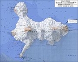
Ross Island
Overview
Volcano
2. Bedrock3. Conduit 4. Base5. Sill6. Dike7. Layers of ash emitted by the volcano8. Flank| 9. Layers of lava emitted by the volcano10. Throat11. Parasitic cone12. Lava flow13. Vent14. Crater15...
es in the Ross Sea
Ross Sea
The Ross Sea is a deep bay of the Southern Ocean in Antarctica between Victoria Land and Marie Byrd Land.-Description:The Ross Sea was discovered by James Ross in 1841. In the west of the Ross Sea is Ross Island with the Mt. Erebus volcano, in the east Roosevelt Island. The southern part is covered...
near the continent of Antarctica, off the coast of Victoria Land
Victoria Land
Victoria Land is a region of Antarctica bounded on the east by the Ross Ice Shelf and the Ross Sea and on the west by Oates Land and Wilkes Land. It was discovered by Captain James Clark Ross in January 1841 and named after the UK's Queen Victoria...
in McMurdo Sound.
Because of the persistent presence of the ice sheet, the island is sometimes taken to be part of Antarctica. Its area is 2460 km² (950 sq mi); only a small portion of the island is free of ice and snow. The planet's southernmost active volcano, Erebus
Mount Erebus
Mount Erebus in Antarctica is the southernmost historically active volcano on Earth, the second highest volcano in Antarctica , and the 6th highest ultra mountain on an island. With a summit elevation of , it is located on Ross Island, which is also home to three inactive volcanoes, notably Mount...
(3794 m (12,448 ft)), as well as the dormant volcano Terror
Mount Terror (Antarctica)
Mount Terror is a large shield volcano that forms the eastern part of Ross Island, Antarctica. It has numerous cinder cones and domes on the flanks of the shield and is mostly under snow and ice. It is the second largest of the four volcanoes which make up Ross Island and is somewhat overshadowed...
(3230 m (10,597 ft)), are situated on the island.
Unanswered Questions