
Petrified Forest National Park
Encyclopedia
Petrified Forest National Park is a United States national park in Navajo
and Apache
counties in northeastern Arizona
. The park's headquarters are about 26 miles (41.8 km) east of Holbrook
along Interstate 40
(I-40), which parallels a railroad line, the Puerco River
, and historic U.S. Route 66
, all crossing the park roughly east–west. Named for its large deposits of petrified wood
, the park covers about 146 mi2, encompassing semi-desert shrub steppe
as well as highly eroded and colorful badlands
. The site, the northern part of which extends into the Painted Desert
, was declared a National Monument in 1906 and a national park in 1962. About 600,000 people visit the park each year and take part in activities including sightseeing, photography, hiking, and backpacking
.
Averaging about 5400 feet (1,645.9 m) in elevation, the park has a dry windy climate with temperatures that vary from summer highs of about 100 °F (37.8 °C) to winter lows well below freezing. More than 400 species of plants, dominated by grasses such as bunchgrass
, blue grama
, and sacaton
, are found in the park. Fauna include larger animals such as pronghorn
s, coyotes, and bobcat
s; many smaller animals such as deer mice
; snakes; lizards; seven kinds of amphibian
s, and more than 200 species of birds, some of which are permanent residents and many of which are migratory
. About half of the park is designated wilderness
.
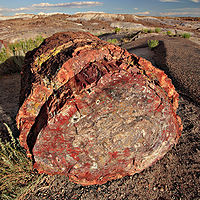
The Petrified Forest is known for its fossils, especially fallen trees that lived in the Late Triassic
, about 225 million years ago. The sediments containing the fossil logs are part of the widespread and colorful Chinle Formation
, from which the Painted Desert gets its name. Beginning about 60 million years ago, the Colorado Plateau
, of which the park is part, was pushed upward by tectonic
forces and exposed to increased erosion. All of the park's rock layers above the Chinle, except geologically recent ones found in parts of the park, have been removed by wind and water. In addition to petrified logs, fossils found in the park have included Late Triassic ferns, cycads, ginkgo
es, and many other plants as well as fauna including giant reptiles called phytosaur
s, large amphibian
s, and early dinosaurs. Paleontologists
have been unearthing and studying the park's fossils since the early 20th century.
The park's earliest human inhabitants arrived at least 8,000 years ago. By about 2,000 years ago, they were growing corn in the area and shortly thereafter building pit houses
in what would become the park. Later inhabitants built above-ground dwellings called pueblo
s. Although a changing climate caused the last of the park's pueblos to be abandoned by about 1400 CE, more than 600 archeological sites, including petroglyph
s, have been discovered in the park. In the 16th century, Spanish explorers visited the area, and by the mid-19th century a U.S. team had surveyed an east–west route through the park and noted the petrified wood. Later roads and a railway followed similar routes and gave rise to tourism and, before the park was protected, to private removal of the park's fossils. Theft of petrified wood remains a problem in the 21st century.
and Navajo County
in northeastern Arizona. The park is about 30 miles (48.3 km) long from north to south, and its width varies from a maximum of about 12 miles (19.3 km) in the north to a minimum of about 1 miles (1.6 km) along a narrow corridor between the north and south, where the park widens again to about 4 to 5 mi (6.4 to 8 km).
I-40
, former U.S. Route 66
, the BNSF Railway
, and the Puerco River
bisect the park generally east–west along a similar route. Adamana
, a ghost town
, is about 1 miles (1.6 km) west of the park along the BNSF tracks. Holbrook
, about 26 miles (41.8 km) west of park headquarters along I-40, is the nearest city. Bisecting the park north–south is Park Road, which runs between I-40 near park headquarters on the north and U.S. Route 180
on the south. Historic Highway 180, an earlier alignment of the modern route, crosses the southern edge of the park. Like Route 66, it has deteriorated and is closed. Many unpaved maintenance roads, closed to the public, intersect Park Road at various points.
The park covers about 146 mi2. The Navajo Nation
borders the park on the north and northeast. State-owned land, federal land controlled by the Bureau of Land Management
, and private land, much of it used for cattle ranching, form the other borders. The park’s elevation above sea level varies from a low of 5340 feet (1,627.6 m) along the Puerco River to a high of 6230 feet (1,898.9 m) at Pilot Rock; the average elevation is about 5400 feet (1,645.9 m). The terrain varies from gentle hills and major petrified wood deposits in the south to eroded badlands in the north. Most of the park's intermittent streams—including Lithodendron Wash, Dead Wash, Ninemile Wash, and Dry Wash—empty into the Puerco River. In the southern part of the park, Cottonwood Wash and Jim Camp Wash flow into the Little Colorado River
.
s, especially of fallen trees that lived in the Late Triassic
period of the Mesozoic
era, about 225 million years ago. During this period, the region that is now the park was near the equator on the southwestern edge of the supercontinent Pangaea
, and its climate was humid and sub-tropical. What later became northeastern Arizona was a low plain flanked by mountains to the south and southeast and a sea to the west. Streams flowing across the plain from the highlands deposited inorganic sediment and organic matter, including trees as well as other plants and animals that had entered or fallen into the water. Although most organic matter decays rapidly or is eaten by other organisms, some is buried so quickly that it remains intact and may become fossilized. Within the park, the sediments containing the fossil logs for which the park is named are part of the Chinle Formation
.
The colorful Chinle, which appears on the surface in many parts of the southwestern United States and from which the Painted Desert
gets its name, is up to 800 feet (243.8 m) thick in the park. It consists of a variety of sedimentary rock
s including beds of soft, fine-grained mudstone
, siltstone
, and claystone
—much of which is bentonite
—as well as harder sandstone
and conglomerate
, and limestone
. Exposed to wind and water, the Chinle usually erodes differentially into badlands made up of cliffs, gullies, mesa
s, butte
s, and rounded hills. Its bentonite clay, which swells when wet and shrinks while drying, causes surface movement and cracking that discourages plant growth. Lack of plant cover makes the Chinle especially susceptible to weathering.
About 60 million years ago, tectonic
movements of Earth’s crust began to uplift the Colorado Plateau
, of which the Painted Desert is part. Eventually parts of the plateau rose to 10000 feet (3,048 m) above sea level. This warping of Earth’s surface led to the gradual and continuing destruction of the plateau by erosion. An unconformity
(break in the rock record) of about 200 million years occurs within the park, where erosion has removed all the rock layers above the Chinle except geologically recent ones. The Bidahochi Formation, laid down only 8 to 4 million years ago, rests directly atop the Chinle, and rocks laid down in the Jurassic
, Cretaceous
, and much of the Tertiary
are absent.
During the period of the Bidahochi deposition
, a large lake basin covered much of northeastern Arizona. The older (lower) layers of the formation consist of fluvial
and lacustrine
(lake-related) deposits of silt, sand, and clay. The younger (upper) Bidahochi contains ash and lava
from volcanoes that erupted nearby and as far away as southwestern Nevada. Although much of the Bidahochi has since eroded, a small part of it outcrops in the northern part of the park—on Pilot Rock in the park’s wilderness section and along the rim of the Painted Desert between Pintado and Tawa points. Exposed by erosion of the Bidahochi are volcanic landforms called maar
s (flat-bottomed, roughly circular volcanic craters of explosive origin). A maar vent can be seen from the Pintado Point lookout.
During the Quaternary Period (1.8 million years ago to today), deposits of windblown sand and alluvium
covered much of the Chinle and Bidahochi. Older dunes range in age from 500,000 years at higher elevations in the northern part of the park to about 10,000 years in sandy drainage areas such as Lithodendron Wash. Stabilized by grasses and other vegetation, young dunes of about 1,000 years old are found throughout the park.
 During the Late Triassic, downed trees accumulating in river channels in what became the park were buried periodically by sediment containing volcanic ash
. Groundwater dissolved silica (silicon dioxide) from the ash and carried it into the logs, where it formed quartz
crystals that gradually replaced the organic matter. Traces of iron oxide
and other substances combined with the silica to create varied colors in the petrified wood.
In Petrified Forest National Park, most of the logs in the park retained their original external form during petrification
but lost their internal structure. However, a small fraction of the logs and most of the park’s petrified animal bones have cell
s and other spaces that are mineral-filled but still retain much of their original organic structure. With these permineralized
fossils, it is possible to study the cellular make-up of the original organisms with the aid of a microscope. Other organic matter—typically leaves, seeds, cones, pollen grains, spore
s, small stems, and fish, insect, and animal remains—have been preserved in the park as compression fossil
s, flattened by the weight of the sediments above until only a thin film remains in the rock.
Much of the park’s petrified wood is from Araucarioxylon arizonicum
trees, while some found in the northern part of the park is from Woodworthia arizonica and Schilderia adamanica trees. At least nine species of fossil trees from the park have been identified; all are extinct. The park has many other kinds of fossils besides trees. The Chinle, considered one of the richest Late Triassic fossil-plant deposits in the world, contains more than 200 fossil plant taxa
. Plant groups represented in the park include lycopods, ferns, cycad
s, conifers, ginkgo
es, as well as unclassified forms. The park has also produced many fossil vertebrate
s—including giant crocodile-like reptiles called phytosaur
s, large salamander-like amphibians called Buettneria
, and early dinosaurs—and invertebrate
s, including freshwater snails and clams.
Winter winds can reach 60 miles per hour (96.6 km/h). Summer breezes are lighter, but the 10 miles per hour (16.1 km/h) average wind causes frequent sandstorms and dust devil
s, some of which reach altitudes of several thousand feet.
Rain is heaviest from July through September, when about half of the park's annual average precipitation falls during short, violent thunderstorms. August is generally the wettest month. At an elevation of more than 5000 feet (1,524 m), Petrified Forest National Park has a chance of light snow from October through March, although snow cover rarely persists. The average relative humidity
of the area is well below 50 percent and at times less than 15 percent.
spear points, the earliest artifacts of Paleo-Indians found in the park, are at least that old. Between 6000 BCE
and 1 CE
, the Archaic–Early Basketmaker Era
, nomadic groups established seasonal camps in the Petrified Forest from which they hunted small game such as rabbits, pronghorn
antelope, and deer and harvested seeds from Indian ricegrass and other wild plants. Around 150 BCE, they began to grow corn in the area. By 1 CE, as their farming techniques improved, some built houses in the Petrified Forest and began to stay there year-round.
The early farmers from the Early Basketmaker II Era
, lived in the Petrified Forest from about 1 CE to about 800 CE. They occupied pit houses at fewer than 100 sites, at first on mesa
s or other vantage points and later at the base of bluffs
and in lowlands, where the soil was better. As climatic conditions worsened for farming between 750 and 900 CE, the settlements changed with the Pueblo I Era
. Rather than below-ground pits, the Pueblo Builders constructed above-ground houses and storerooms that may have been capable of storing food for more than one year. At the same time, climatic conditions changed again, this time for the better, between 900 and 1275 CE. More than 200 pueblo-builder sites have been identified in the park at a wide variety of locations—at the mouths of washes
, near seep
s, and on moisture-holding sand dunes.
During the Pueblo I Era, most sites were single-family homes, but as soils became exhausted many sites were abandoned by 1250 CE in favor of very large multi-room pueblos close to more dependable sources of water. The Pueblo Builders constructed two of these large pueblos, one called Stone Axe, about 0.5 mile (0.80467 km) east of the park, and the other at Puerco Pueblo, which overlooks the Puerco River near the middle of the park. There they built about 100 one-story rooms around an open plaza. The rooms had no windows or doors but each could be entered by climbing a ladder and descending through a hole in the roof. At its peak, perhaps 200 people lived in this pueblo. Over time, however, a persistently dry climate led to out-migration, and the last residents abandoned Puerco Pueblo in about 1380 CE.
At Puerco Pueblo and many other sites within the park, petroglyph
s—images, symbols, or
designs—have been scratched, pecked, carved, or incised on rock surfaces, often on a patina known as desert varnish
. Most of the petroglyphs in Petrified Forest National Park are thought to be between 650 and 2,000 years old.
From the 16th through the 18th centuries, explorers looking for routes between Spanish colonies along the Rio Grande
to the southeast and other Spanish colonies on the Pacific coast to the west passed near or through the area, which they called El Desierto Pintado, the Painted Desert. However, the park's oldest Spanish inscriptions, left by descendants of the region's early Spanish colonists, date only to the late 19th century.
became part of the U.S., explorers continued to look for good east–west routes along the 35th parallel
. In 1853, a crew led by U.S. Army Lieutenant Amiel Whipple
surveyed along a sandy wash in the northern part of the Petrified Forest. So impressed was Whipple by the petrified wood along the banks of the arroyo
that he named it Lithodendron Creek (Stone Tree Creek). Geologist Jules Marcou
, a member of the Whipple expedition, observed that the petrified trees were from the Triassic.
A slightly later route along the parallel was a wagon road, built between 1857 and 1860, that involved experimental use of camels as transport. In the late 19th century, settlers and private stagecoach
companies followed similar east–west routes. Homesteaders who stayed in the area developed cattle ranches on the grasslands, and cattle grazed in the Petrified Forest until the mid-20th century.
Also close to the 35th parallel was the Atlantic and Pacific Railroad
. Its opening in the early 1880s led to the founding of towns like Holbrook and Adamana. Visitors could stop at the Adamana train station, book a hotel room, and take a tour of what was then called the Chalcedony
Forest. Over the years, the line changed hands, becoming the Atchison, Topeka and Santa Fe Railway
, and then the BNSF. More than 60 BNSF trains, mostly carrying freight, pass through the park every day. U.S. Route 66, a former transcontinental auto highway developed in 1926 from part of the National Old Trails Road, ran parallel to the railroad tracks until it was decommissioned in 1985. The park has preserved within its boundaries a small grassy section of the road. Interstate 40
, which crosses the park, replaced the older highway.
Increasing tourist and commercial interest in petrified wood during the late 19th century began to alarm residents of the region. In 1895, the Arizona Territorial Legislature
asked the U.S. Congress
to create a petrified forest national park. Although this first attempt failed, in 1906 the Antiquities Act
signed by President Theodore Roosevelt
was used to create the Petrified Forest National Monument. Between 1934 and 1942, the federal Civilian Conservation Corps
built road, trails, and structures in the monument, and the government acquired additional land in the Painted Desert section. The monument became a national park in 1962. Six years after the signing of the Wilderness Act
in 1964 by President Lyndon B. Johnson
, wilderness
areas (where human activity is limited), were designated in the park. In 2004, President George W. Bush
signed a bill authorizing the eventual expansion of the park from 93,353 acres (about 146 mi2 or 378 km2) to 218,533 acres (about 341 mi2 or 884 km2). Theft of petrified wood is still a problem. Despite a guard force of seven National Park Service
rangers
, fences, warning signs, and the threat of a $325 fine, an estimated 12 short tons (10,886.2 kg) of the fossil wood is stolen from the Petrified Forest every year.
Jessee Walter Fewkes
, the first archeologist to visit Puerco Ruin, predicted in the late 19th century that it would yield many artifacts. Conservationist John Muir
conducted the first excavations of the ruin in 1905–06. Although he did not publish his findings, he urged the federal government to preserve Petrified Forest. Professional archeological work in the park began in the early 20th century when Walter Hough
conducted excavations at Puerco Ruin and other sites. In 1919, a phytosaur skull was discovered near Blue Mesa in the Petrified Forest and sent to the Museum of Paleontology
in Berkeley, California. In 1921, Annie Alexander
, founder of the museum, visited Blue Mesa to collect more of the phytosaur and other specimens; this led to further excavations by paleontologist Charles Camp
. Since then, more than 250 fossil sites have been documented in the park. In the 1930s, the Civil Works Administration
funded research in the park by archeologists H.P. Mera and C.B. Cosgrove. A National Park Service resurvey of the Petrified Forest in the early 1940s identified most of the large sites with stone ruins, and subsequent surveys since 1978 have identified a total of more than 600 artifact sites, many of them small. Research in paleontology and archeology continues at the park in the 21st century.
, occur in the park. Although the park is known for its fossils and eroded badlands, its main environment is semi-desert shrub steppe
. Protected from development and overgrazing for many years, the park has some of the best grassland in northeastern Arizona. In the northern part of the park, the volcanic soils of the Bidahochi Formation support abundant plant life along the Painted Desert rim. In contrast to the relatively bare badlands below, the rim is covered with shrubs, small trees, grasses, and herbs.
The dominant plants in the park include more than 100 grass species, many native to the region. Growing among the grasses are flowering species such as evening primrose
, mariposa lily
, and blue flax
, and shrubs such as sagebrush
, saltbush
, and rabbitbrush
. Among the wide variety of grasses are native perennial bunchgrass
, blue grama
, sacaton
, sideoats grama, bearded sprangletop
, and bush muhly
. Invasive species that crowd out slower-spreading natives include annual lovegrass and brome
(cheat grass).
Trees and shrubs grow in riparian zone
s along the park's washes. Willows and cottonwoods are the larger plants, joined by rushes and sedges. Here the invasive Eurasian tamarisk, also known as saltcedar, threatens native plants by crowding, using most of the available water, and increasing soil salinity by exuding salt through its leaves.
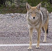 Some of the larger animals roaming the grasslands include pronghorn
s, black-tailed jackrabbit
s (hares), Gunnison's prairie dog
s, coyote
s, bobcat
s and foxes. Pronghorns, the fastest land animals in North America, are capable of 60 miles per hour (96.6 km/h) sprints. The blood vessels in the huge, thin-walled ears of the jackrabbits act as heat exchangers. These hares are known for their bursts of speed, long leaps, and zigzag routes, meant to protect them from being eaten by golden eagles and other predators. The prairie dogs live in large colonies or "towns", near which many other species find food and shelter. Coyotes dine largely on rodents but also eat fruits, reptiles, insects, small mammals, birds, and carrion
.
Bobcats and bullsnake
s hunt smaller animals, such as deer mice
and white-tailed antelope squirrel
s in the park's riparian zones. Western pipistrelle
bats feast on insects, and pallid bat
s eat beetles, centipede
s, cicada
s, praying mantis
es, scorpion
s, and other arthropod
s. On the Painted Desert rim, small animals find food and shelter among the denser foliage, and mule deer
sometimes frequent the area.
More than 16 kinds of lizards and snakes live in various habitats in the park and consume large quantities of insects, spiders, scorpions, other reptiles, and small mammals. The collared lizard
, which occurs in every habitat, is the largest and most often seen. Plateau striped whiptails
, a species consisting entirely of females, prefer grasslands and developed areas. Side-blotched lizard
s live in rocky areas of the park but are seldom seen. Gopher snakes, which sometimes imitate rattlesnakes when disturbed, are among the most common snakes in the park. The Western rattlesnake
, the only venomous snake found in the park, prefers grasslands and shrub areas.
Seven kinds of amphibian
s, which drink no water but absorb it through their permeable skins, have been identified in Petrified Forest National Park. Tiger salamanders
, found in grassland and near major drainages, are the only salamander species known in Arizona. Woodhouse’s toads, which are seldom seen, are the largest toads in the park. They like grasslands, riparian corridors, and developed areas. Red-spotted toads, most active in the rainy season, July through September, are found in rocky areas near streams and in canyons. The Great Plains toad, the most common toad in the park, prefers grasslands. Resident Spadefoot toad
s include the New Mexico, plains, and Couch's varieties.
 A survey conducted in 2006 identified 216 species of birds known to have occurred in Petrified Forest National Park since the park became a protected area in 1906. Of those, 33 species breed within the park, 6 other species probably do, and 18 species live in the park year-round. Thirty-five species live in the park only during the summer and 11 species only during the winter. The greatest diversity of birds occurs during fall and winter migrations.
Raptor
s, songbirds, and ground birds are found in the park's grassland, while the Puerco River's riparian corridor is a good place for year-round residents as well as migrants such as warbler
s, vireo
s, avocets
, and killdeer
. Developed areas around the visitor center and museum attract Western Tanager
s, Hermit Warbler
s, House Finch
es, and others. Occasional shorebirds and Eastern birds also visit the park.
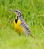
Birds commonly seen in the park include the Common Raven
and the Western Meadowlark
, known for its charming song. Anna's Hummingbird
, which can hover and fly backwards as well as forwards, is among the smallest birds in the park. The largest is the Golden Eagle
, with a wingspan of up to 7 feet (2 m).
(an historic museum and bookstore) is open from 9 a.m. to 5 p.m. year-round except Christmas. Park clocks are always set to Mountain Standard Time
.
The Painted Desert Visitor Center, designed by modernist architect Richard Neutra
, is part of the Painted Desert Community Complex Historic District
and is on the National Register of Historic Places
. Eight other sites within the park are also on the National Register, including the Painted Desert Inn and associated cabins, the Agate House Pueblo
, the Painted Desert Petroglyphs and Ruins Archeological District, Newspaper Rock Petroglyphs Archeological District, Puerco Ruins and Petroglyphs, the Flattops Site (an archeological site), the Twin Buttes Archeological District, and the 35th Parallel Route (also known as the Beale Camel Trail). The Painted Desert Inn was upgraded to a National Historic Landmark
in 1987.
The visitor center, which is near the north entrance to the park, offers visitor information and shows a 20-minute orientation movie, "Timeless Impressions", once every half-hour. It has a bookstore, exhibits, a restaurant open from 8 a.m. to 3 p.m., a gift shop, a gas station, a post office open from 11 a.m. to 1 p.m. Monday through Friday, a postal drop box, and public restrooms. The Rainbow Forest Museum complex 2 miles (3.2 km) north of the park's south entrance offers services including information and "Timeless Impressions" showings once every half-hour. It has a bookstore, fossil exhibits, an interactive Triassic Virtual Tour, limited food service, a gift shop, and public restrooms. The Painted Desert Inn, 2 miles (3.2 km) north of the Painted Desert Visitor Center, offers visitor information. It has a bookstore, museum exhibits (including the building itself), and public restrooms.
No campgrounds or overnight lodging are available in the park, although nearby communities such as Holbrook offer motels and other accommodations. Overnight parking is not allowed except in the case of backpacker
s with wilderness hiking permits. Sightseeing is available by private automobile, motorcycle, commercial tour, bicycle, and hiking. The park road, parking lots, and turn-outs are big enough to accommodate large recreational vehicles. Off-road vehicle travel, including by mountain bike
, is not allowed. Bicycles may use only paved roads—the 28 miles (45.1 km) park road and the 3.5 miles (5.6 km) loop around Blue Mesa.
The park's seven maintained hiking trails, some paved and some unpaved, vary in length from less than 0.5 mile (0.80467 km) to nearly 3 miles (4.8 km). Pets are allowed on these trails if kept on a leash, but bicycles are not allowed. These named trails are Painted Desert Rim, Puerco Pueblo, Blue Mesa, Crystal Forest, Giant Logs, Long Logs, and Agate House. Hikers and backpackers may also visit the park's wilderness areas. Free permits are required for overnight stays; they are issued from the Painted Desert Visitor Center, Painted Desert Inn, and Rainbow Forest Museum. Most backpackers enter the wilderness at the north end of the park, where parking and an access trail are available at Painted Desert Inn. Group camping is limited to eight people. Horseback riding is allowed in the wilderness areas; water for horses is available at the service station near the Painted Desert Visitor Center. Riders and hikers are asked to travel along dry washes as much as possible to reduce the impact on fragile desert soils.
Rangers offer a variety of programs about the park. Regularly scheduled events include a Painted Desert Inn tour, a Triassic program at the Rainbow Forest Museum sunroom, a talk or walk along the Giant Logs Trail behind the museum, and a Puerco Pueblo guided walk. The park hosts special events related to Earth Science Week
and National American Indian Heritage Month
. On Saturdays from Memorial Day
weekend through Labor Day
at the Painted Desert Inn, artisans from the region give cultural demonstrations related to ancient peoples, intertribal relationships, and European-descent cultures. For students and teachers, the rangers offer educational materials and field-trip talks. Artists-in-residence work in the park between May and November.
Navajo County, Arizona
-2010:Whereas according to the 2010 U.S. Census Bureau:*49.3% White*0.9% Black*43.4% Native American*0.5% Asian*0.1% Native Hawaiian or Pacific Islander*2.5% Two or more races*3.3% Other races*10.8% Hispanic or Latino -2000:...
and Apache
Apache County, Arizona
-2010:Whereas according to the 2010 U.S. Census Bureau:*23.3% White*0.2% Black*72.9% Native American*0.3% Asian*0.0% Native Hawaiian or Pacific Islander*2.0% Two or more races*1.3% Other races*5.8% Hispanic or Latino -2000:...
counties in northeastern Arizona
Arizona
Arizona ; is a state located in the southwestern region of the United States. It is also part of the western United States and the mountain west. The capital and largest city is Phoenix...
. The park's headquarters are about 26 miles (41.8 km) east of Holbrook
Holbrook, Arizona
-Historical events:*During 1881 & 1882, railroad tracks were laid down and a railroad station was built. The community was then named Holbrook after the first engineer of the Atlantic and Pacific Railroad...
along Interstate 40
Interstate 40
Interstate 40 is the third-longest major east–west Interstate Highway in the United States, after I-90 and I-80. Its western end is at Interstate 15 in Barstow, California; its eastern end is at a concurrency of U.S. Route 117 and North Carolina Highway 132 in Wilmington, North Carolina...
(I-40), which parallels a railroad line, the Puerco River
Puerco River
The Puerco River in northwestern New Mexico and northeastern Arizona flows through arid terrain including the Painted Desert. The main tributary of the Little Colorado River, it drains an area of about and is long. The river's average discharge is very low, less than in normal years, because its...
, and historic U.S. Route 66
U.S. Route 66
U.S. Route 66 was a highway within the U.S. Highway System. One of the original U.S. highways, Route 66 was established on November 11, 1926 -- with road signs erected the following year...
, all crossing the park roughly east–west. Named for its large deposits of petrified wood
Petrified wood
Petrified wood is the name given to a special type of fossilized remains of terrestrial vegetation. It is the result of a tree having turned completely into stone by the process of permineralization...
, the park covers about 146 mi2, encompassing semi-desert shrub steppe
Steppe
In physical geography, steppe is an ecoregion, in the montane grasslands and shrublands and temperate grasslands, savannas, and shrublands biomes, characterized by grassland plains without trees apart from those near rivers and lakes...
as well as highly eroded and colorful badlands
Badlands
A badlands is a type of dry terrain where softer sedimentary rocks and clay-rich soils have been extensively eroded by wind and water. It can resemble malpaís, a terrain of volcanic rock. Canyons, ravines, gullies, hoodoos and other such geological forms are common in badlands. They are often...
. The site, the northern part of which extends into the Painted Desert
Painted Desert, Arizona
The Painted Desert is a area of badlands located in Northern Arizona in the United States. The Arizona desert stretches from the Grand Canyon National Park into the Petrified Forest National Park and runs roughly astride and just north of the Little Colorado and the Puerco Rivers...
, was declared a National Monument in 1906 and a national park in 1962. About 600,000 people visit the park each year and take part in activities including sightseeing, photography, hiking, and backpacking
Backpacking (wilderness)
Backpacking combines the activities of hiking and camping for an overnight stay in backcountry wilderness...
.
Averaging about 5400 feet (1,645.9 m) in elevation, the park has a dry windy climate with temperatures that vary from summer highs of about 100 °F (37.8 °C) to winter lows well below freezing. More than 400 species of plants, dominated by grasses such as bunchgrass
Tussock (grass)
Tussock grasses or bunch grasses are found as native plants in natural ecosystems, as forage in pastures, and as ornamental grasses in gardens....
, blue grama
Blue grama
Blue Grama, Bouteloua gracilis, is a long-lived, warm season, C4 perennial grass native to North America. It is most commonly found from Alberta east to Manitoba and south across the Rocky Mountains, Great Plains, and Midwest states to Mexico...
, and sacaton
Sporobolus
Sporobolus is a genus of grasses in the family Poaceae. They are usually called dropseed grasses or sacaton grasses. They are typical prairie and savanna plants, and they occur in other types of open habitat in warmer climates....
, are found in the park. Fauna include larger animals such as pronghorn
Pronghorn
The pronghorn is a species of artiodactyl mammal endemic to interior western and central North America. Though not an antelope, it is often known colloquially in North America as the prong buck, pronghorn antelope, or simply antelope, as it closely resembles the true antelopes of the Old World and...
s, coyotes, and bobcat
Bobcat
The bobcat is a North American mammal of the cat family Felidae, appearing during the Irvingtonian stage of around 1.8 million years ago . With twelve recognized subspecies, it ranges from southern Canada to northern Mexico, including most of the continental United States...
s; many smaller animals such as deer mice
Peromyscus
The genus Peromyscus contains the animal species commonly referred to as deer mice. This is a genus of New World mouse only distantly related to the common house mouse and laboratory mouse, Mus musculus...
; snakes; lizards; seven kinds of amphibian
Amphibian
Amphibians , are a class of vertebrate animals including animals such as toads, frogs, caecilians, and salamanders. They are characterized as non-amniote ectothermic tetrapods...
s, and more than 200 species of birds, some of which are permanent residents and many of which are migratory
Bird migration
Bird migration is the regular seasonal journey undertaken by many species of birds. Bird movements include those made in response to changes in food availability, habitat or weather. Sometimes, journeys are not termed "true migration" because they are irregular or in only one direction...
. About half of the park is designated wilderness
Wilderness
Wilderness or wildland is a natural environment on Earth that has not been significantly modified by human activity. It may also be defined as: "The most intact, undisturbed wild natural areas left on our planet—those last truly wild places that humans do not control and have not developed with...
.
The Petrified Forest is known for its fossils, especially fallen trees that lived in the Late Triassic
Late Triassic
The Late Triassic is in the geologic timescale the third and final of three epochs of the Triassic period. The corresponding series is known as the Upper Triassic. In the past it was sometimes called the Keuper, after a German lithostratigraphic group that has a roughly corresponding age...
, about 225 million years ago. The sediments containing the fossil logs are part of the widespread and colorful Chinle Formation
Chinle Formation
The Chinle is a geologic formation that is spread across the U.S. states of northern Arizona, Nevada, Utah, western New Mexico, and western Colorado. The Chinle is controversially considered to be synonymous to the Dockum Group in eastern Colorado, eastern New Mexico, southwestern Kansas, the...
, from which the Painted Desert gets its name. Beginning about 60 million years ago, the Colorado Plateau
Colorado Plateau
The Colorado Plateau, also called the Colorado Plateau Province, is a physiographic region of the Intermontane Plateaus, roughly centered on the Four Corners region of the southwestern United States. The province covers an area of 337,000 km2 within western Colorado, northwestern New Mexico,...
, of which the park is part, was pushed upward by tectonic
Plate tectonics
Plate tectonics is a scientific theory that describes the large scale motions of Earth's lithosphere...
forces and exposed to increased erosion. All of the park's rock layers above the Chinle, except geologically recent ones found in parts of the park, have been removed by wind and water. In addition to petrified logs, fossils found in the park have included Late Triassic ferns, cycads, ginkgo
Ginkgo
Ginkgo , also spelled gingko and known as the Maidenhair Tree, is a unique species of tree with no close living relatives...
es, and many other plants as well as fauna including giant reptiles called phytosaur
Phytosaur
Phytosaurs are an extinct group of large semi-aquatic Late Triassic archosaurs. Phytosaurs belong to the family Phytosauridae and the order Phytosauria. They were long-snouted and heavily armoured, bearing a remarkable resemblance to modern crocodiles in size, appearance, and lifestyle, an example...
s, large amphibian
Amphibian
Amphibians , are a class of vertebrate animals including animals such as toads, frogs, caecilians, and salamanders. They are characterized as non-amniote ectothermic tetrapods...
s, and early dinosaurs. Paleontologists
Paleontology
Paleontology "old, ancient", ὄν, ὀντ- "being, creature", and λόγος "speech, thought") is the study of prehistoric life. It includes the study of fossils to determine organisms' evolution and interactions with each other and their environments...
have been unearthing and studying the park's fossils since the early 20th century.
The park's earliest human inhabitants arrived at least 8,000 years ago. By about 2,000 years ago, they were growing corn in the area and shortly thereafter building pit houses
Dugout (shelter)
A dugout or dug-out, also known as a pithouse, pit-house, earth lodge, mud hut, is a shelter for humans or domesticated animals and livestock based on a hole or depression dug into the ground. These structures are one of the most ancient types of human housing known to archeologists...
in what would become the park. Later inhabitants built above-ground dwellings called pueblo
Pueblo
Pueblo is a term used to describe modern communities of Native Americans in the Southwestern United States of America. The first Spanish explorers of the Southwest used this term to describe the communities housed in apartment-like structures built of stone, adobe mud, and other local material...
s. Although a changing climate caused the last of the park's pueblos to be abandoned by about 1400 CE, more than 600 archeological sites, including petroglyph
Petroglyph
Petroglyphs are pictogram and logogram images created by removing part of a rock surface by incising, picking, carving, and abrading. Outside North America, scholars often use terms such as "carving", "engraving", or other descriptions of the technique to refer to such images...
s, have been discovered in the park. In the 16th century, Spanish explorers visited the area, and by the mid-19th century a U.S. team had surveyed an east–west route through the park and noted the petrified wood. Later roads and a railway followed similar routes and gave rise to tourism and, before the park was protected, to private removal of the park's fossils. Theft of petrified wood remains a problem in the 21st century.
Geography
Petrified Forest National Park straddles the border between Apache CountyApache County, Arizona
-2010:Whereas according to the 2010 U.S. Census Bureau:*23.3% White*0.2% Black*72.9% Native American*0.3% Asian*0.0% Native Hawaiian or Pacific Islander*2.0% Two or more races*1.3% Other races*5.8% Hispanic or Latino -2000:...
and Navajo County
Navajo County, Arizona
-2010:Whereas according to the 2010 U.S. Census Bureau:*49.3% White*0.9% Black*43.4% Native American*0.5% Asian*0.1% Native Hawaiian or Pacific Islander*2.5% Two or more races*3.3% Other races*10.8% Hispanic or Latino -2000:...
in northeastern Arizona. The park is about 30 miles (48.3 km) long from north to south, and its width varies from a maximum of about 12 miles (19.3 km) in the north to a minimum of about 1 miles (1.6 km) along a narrow corridor between the north and south, where the park widens again to about 4 to 5 mi (6.4 to 8 km).
I-40
Interstate 40
Interstate 40 is the third-longest major east–west Interstate Highway in the United States, after I-90 and I-80. Its western end is at Interstate 15 in Barstow, California; its eastern end is at a concurrency of U.S. Route 117 and North Carolina Highway 132 in Wilmington, North Carolina...
, former U.S. Route 66
U.S. Route 66
U.S. Route 66 was a highway within the U.S. Highway System. One of the original U.S. highways, Route 66 was established on November 11, 1926 -- with road signs erected the following year...
, the BNSF Railway
BNSF Railway
The BNSF Railway is a wholly owned subsidiary of Berkshire Hathaway Inc., and is headquartered in Fort Worth, Texas. It is one of seven North American Class I railroads and the second largest freight railroad network in North America, second only to the Union Pacific Railroad, its primary...
, and the Puerco River
Puerco River
The Puerco River in northwestern New Mexico and northeastern Arizona flows through arid terrain including the Painted Desert. The main tributary of the Little Colorado River, it drains an area of about and is long. The river's average discharge is very low, less than in normal years, because its...
bisect the park generally east–west along a similar route. Adamana
Adamana, Arizona
Adamana is a ghost town in Apache County in the northeast section of the U.S. state of Arizona. The town was settled in 1896 in what was then the Arizona Territory.-History:...
, a ghost town
Ghost town
A ghost town is an abandoned town or city. A town often becomes a ghost town because the economic activity that supported it has failed, or due to natural or human-caused disasters such as floods, government actions, uncontrolled lawlessness, war, or nuclear disasters...
, is about 1 miles (1.6 km) west of the park along the BNSF tracks. Holbrook
Holbrook, Arizona
-Historical events:*During 1881 & 1882, railroad tracks were laid down and a railroad station was built. The community was then named Holbrook after the first engineer of the Atlantic and Pacific Railroad...
, about 26 miles (41.8 km) west of park headquarters along I-40, is the nearest city. Bisecting the park north–south is Park Road, which runs between I-40 near park headquarters on the north and U.S. Route 180
U.S. Route 180
U.S. Route 180 is an east–west United States highway. Like many three-digit routes, US 180 no longer meets its "parent", US 80. US 80 was decommissioned west of Mesquite, Texas, and was replaced in Texas by Interstate 20 and Interstate 10. The highway's eastern terminus is in Hudson Oaks,...
on the south. Historic Highway 180, an earlier alignment of the modern route, crosses the southern edge of the park. Like Route 66, it has deteriorated and is closed. Many unpaved maintenance roads, closed to the public, intersect Park Road at various points.
The park covers about 146 mi2. The Navajo Nation
Navajo Nation
The Navajo Nation is a semi-autonomous Native American-governed territory covering , occupying all of northeastern Arizona, the southeastern portion of Utah, and northwestern New Mexico...
borders the park on the north and northeast. State-owned land, federal land controlled by the Bureau of Land Management
Bureau of Land Management
The Bureau of Land Management is an agency within the United States Department of the Interior which administers America's public lands, totaling approximately , or one-eighth of the landmass of the country. The BLM also manages of subsurface mineral estate underlying federal, state and private...
, and private land, much of it used for cattle ranching, form the other borders. The park’s elevation above sea level varies from a low of 5340 feet (1,627.6 m) along the Puerco River to a high of 6230 feet (1,898.9 m) at Pilot Rock; the average elevation is about 5400 feet (1,645.9 m). The terrain varies from gentle hills and major petrified wood deposits in the south to eroded badlands in the north. Most of the park's intermittent streams—including Lithodendron Wash, Dead Wash, Ninemile Wash, and Dry Wash—empty into the Puerco River. In the southern part of the park, Cottonwood Wash and Jim Camp Wash flow into the Little Colorado River
Little Colorado River
The Little Colorado River is a river in the U.S. state of Arizona, providing the principal drainage from the Painted Desert region. Together with its major tributary, the Puerco River, it drains an area of about in eastern Arizona and western New Mexico...
.
Geology
Petrified Forest National Park is known for its fossilFossil
Fossils are the preserved remains or traces of animals , plants, and other organisms from the remote past...
s, especially of fallen trees that lived in the Late Triassic
Late Triassic
The Late Triassic is in the geologic timescale the third and final of three epochs of the Triassic period. The corresponding series is known as the Upper Triassic. In the past it was sometimes called the Keuper, after a German lithostratigraphic group that has a roughly corresponding age...
period of the Mesozoic
Mesozoic
The Mesozoic era is an interval of geological time from about 250 million years ago to about 65 million years ago. It is often referred to as the age of reptiles because reptiles, namely dinosaurs, were the dominant terrestrial and marine vertebrates of the time...
era, about 225 million years ago. During this period, the region that is now the park was near the equator on the southwestern edge of the supercontinent Pangaea
Pangaea
Pangaea, Pangæa, or Pangea is hypothesized as a supercontinent that existed during the Paleozoic and Mesozoic eras about 250 million years ago, before the component continents were separated into their current configuration....
, and its climate was humid and sub-tropical. What later became northeastern Arizona was a low plain flanked by mountains to the south and southeast and a sea to the west. Streams flowing across the plain from the highlands deposited inorganic sediment and organic matter, including trees as well as other plants and animals that had entered or fallen into the water. Although most organic matter decays rapidly or is eaten by other organisms, some is buried so quickly that it remains intact and may become fossilized. Within the park, the sediments containing the fossil logs for which the park is named are part of the Chinle Formation
Chinle Formation
The Chinle is a geologic formation that is spread across the U.S. states of northern Arizona, Nevada, Utah, western New Mexico, and western Colorado. The Chinle is controversially considered to be synonymous to the Dockum Group in eastern Colorado, eastern New Mexico, southwestern Kansas, the...
.
The colorful Chinle, which appears on the surface in many parts of the southwestern United States and from which the Painted Desert
Painted Desert, Arizona
The Painted Desert is a area of badlands located in Northern Arizona in the United States. The Arizona desert stretches from the Grand Canyon National Park into the Petrified Forest National Park and runs roughly astride and just north of the Little Colorado and the Puerco Rivers...
gets its name, is up to 800 feet (243.8 m) thick in the park. It consists of a variety of sedimentary rock
Sedimentary rock
Sedimentary rock are types of rock that are formed by the deposition of material at the Earth's surface and within bodies of water. Sedimentation is the collective name for processes that cause mineral and/or organic particles to settle and accumulate or minerals to precipitate from a solution....
s including beds of soft, fine-grained mudstone
Mudstone
Mudstone is a fine grained sedimentary rock whose original constituents were clays or muds. Grain size is up to 0.0625 mm with individual grains too small to be distinguished without a microscope. With increased pressure over time the platey clay minerals may become aligned, with the...
, siltstone
Siltstone
Siltstone is a sedimentary rock which has a grain size in the silt range, finer than sandstone and coarser than claystones.- Description :As its name implies, it is primarily composed of silt sized particles, defined as grains 1/16 - 1/256 mm or 4 to 8 on the Krumbein phi scale...
, and claystone
Claystone
Claystone is a geological term used to describe a clastic sedimentary rock that is composed primarily of clay-sized particles ....
—much of which is bentonite
Bentonite
Bentonite is an absorbent aluminium phyllosilicate, essentially impure clay consisting mostly of montmorillonite. There are different types of bentonite, each named after the respective dominant element, such as potassium , sodium , calcium , and aluminum . Experts debate a number of nomenclatorial...
—as well as harder sandstone
Sandstone
Sandstone is a sedimentary rock composed mainly of sand-sized minerals or rock grains.Most sandstone is composed of quartz and/or feldspar because these are the most common minerals in the Earth's crust. Like sand, sandstone may be any colour, but the most common colours are tan, brown, yellow,...
and conglomerate
Conglomerate (geology)
A conglomerate is a rock consisting of individual clasts within a finer-grained matrix that have become cemented together. Conglomerates are sedimentary rocks consisting of rounded fragments and are thus differentiated from breccias, which consist of angular clasts...
, and limestone
Limestone
Limestone is a sedimentary rock composed largely of the minerals calcite and aragonite, which are different crystal forms of calcium carbonate . Many limestones are composed from skeletal fragments of marine organisms such as coral or foraminifera....
. Exposed to wind and water, the Chinle usually erodes differentially into badlands made up of cliffs, gullies, mesa
Mesa
A mesa or table mountain is an elevated area of land with a flat top and sides that are usually steep cliffs. It takes its name from its characteristic table-top shape....
s, butte
Butte
A butte is a conspicuous isolated hill with steep, often vertical sides and a small, relatively flat top; it is smaller than mesas, plateaus, and table landform tables. In some regions, such as the north central and northwestern United States, the word is used for any hill...
s, and rounded hills. Its bentonite clay, which swells when wet and shrinks while drying, causes surface movement and cracking that discourages plant growth. Lack of plant cover makes the Chinle especially susceptible to weathering.
About 60 million years ago, tectonic
Plate tectonics
Plate tectonics is a scientific theory that describes the large scale motions of Earth's lithosphere...
movements of Earth’s crust began to uplift the Colorado Plateau
Colorado Plateau
The Colorado Plateau, also called the Colorado Plateau Province, is a physiographic region of the Intermontane Plateaus, roughly centered on the Four Corners region of the southwestern United States. The province covers an area of 337,000 km2 within western Colorado, northwestern New Mexico,...
, of which the Painted Desert is part. Eventually parts of the plateau rose to 10000 feet (3,048 m) above sea level. This warping of Earth’s surface led to the gradual and continuing destruction of the plateau by erosion. An unconformity
Unconformity
An unconformity is a buried erosion surface separating two rock masses or strata of different ages, indicating that sediment deposition was not continuous. In general, the older layer was exposed to erosion for an interval of time before deposition of the younger, but the term is used to describe...
(break in the rock record) of about 200 million years occurs within the park, where erosion has removed all the rock layers above the Chinle except geologically recent ones. The Bidahochi Formation, laid down only 8 to 4 million years ago, rests directly atop the Chinle, and rocks laid down in the Jurassic
Jurassic
The Jurassic is a geologic period and system that extends from about Mya to Mya, that is, from the end of the Triassic to the beginning of the Cretaceous. The Jurassic constitutes the middle period of the Mesozoic era, also known as the age of reptiles. The start of the period is marked by...
, Cretaceous
Cretaceous
The Cretaceous , derived from the Latin "creta" , usually abbreviated K for its German translation Kreide , is a geologic period and system from circa to million years ago. In the geologic timescale, the Cretaceous follows the Jurassic period and is followed by the Paleogene period of the...
, and much of the Tertiary
Tertiary
The Tertiary is a deprecated term for a geologic period 65 million to 2.6 million years ago. The Tertiary covered the time span between the superseded Secondary period and the Quaternary...
are absent.
During the period of the Bidahochi deposition
Deposition (geology)
Deposition is the geological process by which material is added to a landform or land mass. Fluids such as wind and water, as well as sediment flowing via gravity, transport previously eroded sediment, which, at the loss of enough kinetic energy in the fluid, is deposited, building up layers of...
, a large lake basin covered much of northeastern Arizona. The older (lower) layers of the formation consist of fluvial
Fluvial
Fluvial is used in geography and Earth science to refer to the processes associated with rivers and streams and the deposits and landforms created by them...
and lacustrine
Lacustrine plain
Some lakes get filled up by the sediments brought down by the rivers and turn into plains in the course of time. Such plains are called lacustrine plains...
(lake-related) deposits of silt, sand, and clay. The younger (upper) Bidahochi contains ash and lava
Lava
Lava refers both to molten rock expelled by a volcano during an eruption and the resulting rock after solidification and cooling. This molten rock is formed in the interior of some planets, including Earth, and some of their satellites. When first erupted from a volcanic vent, lava is a liquid at...
from volcanoes that erupted nearby and as far away as southwestern Nevada. Although much of the Bidahochi has since eroded, a small part of it outcrops in the northern part of the park—on Pilot Rock in the park’s wilderness section and along the rim of the Painted Desert between Pintado and Tawa points. Exposed by erosion of the Bidahochi are volcanic landforms called maar
Maar
A maar is a broad, low-relief volcanic crater that is caused by a phreatomagmatic eruption, an explosion caused by groundwater coming into contact with hot lava or magma. A maar characteristically fills with water to form a relatively shallow crater lake. The name comes from the local Moselle...
s (flat-bottomed, roughly circular volcanic craters of explosive origin). A maar vent can be seen from the Pintado Point lookout.
During the Quaternary Period (1.8 million years ago to today), deposits of windblown sand and alluvium
Alluvium
Alluvium is loose, unconsolidated soil or sediments, eroded, deposited, and reshaped by water in some form in a non-marine setting. Alluvium is typically made up of a variety of materials, including fine particles of silt and clay and larger particles of sand and gravel...
covered much of the Chinle and Bidahochi. Older dunes range in age from 500,000 years at higher elevations in the northern part of the park to about 10,000 years in sandy drainage areas such as Lithodendron Wash. Stabilized by grasses and other vegetation, young dunes of about 1,000 years old are found throughout the park.
Fossils
Volcanic ash
Volcanic ash consists of small tephra, which are bits of pulverized rock and glass created by volcanic eruptions, less than in diameter. There are three mechanisms of volcanic ash formation: gas release under decompression causing magmatic eruptions; thermal contraction from chilling on contact...
. Groundwater dissolved silica (silicon dioxide) from the ash and carried it into the logs, where it formed quartz
Quartz
Quartz is the second-most-abundant mineral in the Earth's continental crust, after feldspar. It is made up of a continuous framework of SiO4 silicon–oxygen tetrahedra, with each oxygen being shared between two tetrahedra, giving an overall formula SiO2. There are many different varieties of quartz,...
crystals that gradually replaced the organic matter. Traces of iron oxide
Iron oxide
Iron oxides are chemical compounds composed of iron and oxygen. All together, there are sixteen known iron oxides and oxyhydroxides.Iron oxides and oxide-hydroxides are widespread in nature, play an important role in many geological and biological processes, and are widely utilized by humans, e.g.,...
and other substances combined with the silica to create varied colors in the petrified wood.
In Petrified Forest National Park, most of the logs in the park retained their original external form during petrification
Petrifaction
In geology, petrifaction, petrification or silicification is the process by which organic material is converted into stone by impregnation with silica. It is a rare form of fossilization...
but lost their internal structure. However, a small fraction of the logs and most of the park’s petrified animal bones have cell
Cell (biology)
The cell is the basic structural and functional unit of all known living organisms. It is the smallest unit of life that is classified as a living thing, and is often called the building block of life. The Alberts text discusses how the "cellular building blocks" move to shape developing embryos....
s and other spaces that are mineral-filled but still retain much of their original organic structure. With these permineralized
Permineralization
Permineralization is a process of fossilization in which mineral deposits form internal casts of organisms. Carried by water, these minerals fill the spaces within organic tissue...
fossils, it is possible to study the cellular make-up of the original organisms with the aid of a microscope. Other organic matter—typically leaves, seeds, cones, pollen grains, spore
Spore
In biology, a spore is a reproductive structure that is adapted for dispersal and surviving for extended periods of time in unfavorable conditions. Spores form part of the life cycles of many bacteria, plants, algae, fungi and some protozoa. According to scientist Dr...
s, small stems, and fish, insect, and animal remains—have been preserved in the park as compression fossil
Compression fossil
A compression fossil is a fossil preserved in sedimentary rock that has undergone physical compression. While it is uncommon to find animals preserved as good compression fossils, it is very common to find plants preserved this way...
s, flattened by the weight of the sediments above until only a thin film remains in the rock.
Much of the park’s petrified wood is from Araucarioxylon arizonicum
Araucarioxylon arizonicum
Araucarioxylon arizonicum is an extinct species of conifer that is the state fossil of Arizona. The species is known from massive tree trunks that weather out of the Chinle Formation in desert badlands of northern Arizona and adjacent New Mexico, most notably in the Petrified Forest National Park...
trees, while some found in the northern part of the park is from Woodworthia arizonica and Schilderia adamanica trees. At least nine species of fossil trees from the park have been identified; all are extinct. The park has many other kinds of fossils besides trees. The Chinle, considered one of the richest Late Triassic fossil-plant deposits in the world, contains more than 200 fossil plant taxa
Taxon
|thumb|270px|[[African elephants]] form a widely-accepted taxon, the [[genus]] LoxodontaA taxon is a group of organisms, which a taxonomist adjudges to be a unit. Usually a taxon is given a name and a rank, although neither is a requirement...
. Plant groups represented in the park include lycopods, ferns, cycad
Cycad
Cycads are seed plants typically characterized by a stout and woody trunk with a crown of large, hard and stiff, evergreen leaves. They usually have pinnate leaves. The individual plants are either all male or all female . Cycads vary in size from having a trunk that is only a few centimeters...
s, conifers, ginkgo
Ginkgo
Ginkgo , also spelled gingko and known as the Maidenhair Tree, is a unique species of tree with no close living relatives...
es, as well as unclassified forms. The park has also produced many fossil vertebrate
Vertebrate
Vertebrates are animals that are members of the subphylum Vertebrata . Vertebrates are the largest group of chordates, with currently about 58,000 species described. Vertebrates include the jawless fishes, bony fishes, sharks and rays, amphibians, reptiles, mammals, and birds...
s—including giant crocodile-like reptiles called phytosaur
Phytosaur
Phytosaurs are an extinct group of large semi-aquatic Late Triassic archosaurs. Phytosaurs belong to the family Phytosauridae and the order Phytosauria. They were long-snouted and heavily armoured, bearing a remarkable resemblance to modern crocodiles in size, appearance, and lifestyle, an example...
s, large salamander-like amphibians called Buettneria
Koskinonodon
Koskinonodon is an extinct genus of large temnospondyl amphibian, formerly named Buettneria. It was very common during the Late Triassic in what is now the American Southwest.-External links:*...
, and early dinosaurs—and invertebrate
Invertebrate
An invertebrate is an animal without a backbone. The group includes 97% of all animal species – all animals except those in the chordate subphylum Vertebrata .Invertebrates form a paraphyletic group...
s, including freshwater snails and clams.
Climate
Average summer daytime temperatures range from 90 °F (32.2 °C) to over 100 °F (37.8 °C). Because the clear skies of the park allow for rapid cooling at night, summer lows are sometimes 40 F-change below the daily highs. July is the warmest month, with an average high of 92 °F (33.3 °C) and an average low of 60 °F (15.6 °C). January is the coldest month, when highs average 48 °F (8.9 °C) and lows average 21 °F (-6.1 °C). The highest recorded temperature was 107 °F (41.7 °C) in 1998, and the lowest was -27 F in 1971.Winter winds can reach 60 miles per hour (96.6 km/h). Summer breezes are lighter, but the 10 miles per hour (16.1 km/h) average wind causes frequent sandstorms and dust devil
Dust devil
A dust devil is a strong, well-formed, and relatively long-lived whirlwind, ranging from small to large . The primary vertical motion is upward...
s, some of which reach altitudes of several thousand feet.
Rain is heaviest from July through September, when about half of the park's annual average precipitation falls during short, violent thunderstorms. August is generally the wettest month. At an elevation of more than 5000 feet (1,524 m), Petrified Forest National Park has a chance of light snow from October through March, although snow cover rarely persists. The average relative humidity
Relative humidity
Relative humidity is a term used to describe the amount of water vapor in a mixture of air and water vapor. It is defined as the partial pressure of water vapor in the air-water mixture, given as a percentage of the saturated vapor pressure under those conditions...
of the area is well below 50 percent and at times less than 15 percent.
Pre-U.S.
More than 600 archeological sites have been found inside the boundaries of Petrified Forest National Park. Evidence suggests that the earliest inhabitants of the park arrived at least 8,000 years ago. Two Folsom-typeFolsom point
Folsom points are a distinct form of chipped stone projectile points associated with the Folsom Tradition of North America. The style of toolmaking was named after Folsom, New Mexico where the first sample was found within the bone structure of a bison in 1927....
spear points, the earliest artifacts of Paleo-Indians found in the park, are at least that old. Between 6000 BCE
Common Era
Common Era ,abbreviated as CE, is an alternative designation for the calendar era originally introduced by Dionysius Exiguus in the 6th century, traditionally identified with Anno Domini .Dates before the year 1 CE are indicated by the usage of BCE, short for Before the Common Era Common Era...
and 1 CE
Common Era
Common Era ,abbreviated as CE, is an alternative designation for the calendar era originally introduced by Dionysius Exiguus in the 6th century, traditionally identified with Anno Domini .Dates before the year 1 CE are indicated by the usage of BCE, short for Before the Common Era Common Era...
, the Archaic–Early Basketmaker Era
Archaic–Early Basketmaker Era
The Archaic–Early Basketmaker Era, 7000 - 1500 BC was an Archaic cultural period of ancestors to the Ancient Pueblo People. They were distinguished from other Archaic people of the Southwest by their basketry which was used to gather and store food...
, nomadic groups established seasonal camps in the Petrified Forest from which they hunted small game such as rabbits, pronghorn
Pronghorn
The pronghorn is a species of artiodactyl mammal endemic to interior western and central North America. Though not an antelope, it is often known colloquially in North America as the prong buck, pronghorn antelope, or simply antelope, as it closely resembles the true antelopes of the Old World and...
antelope, and deer and harvested seeds from Indian ricegrass and other wild plants. Around 150 BCE, they began to grow corn in the area. By 1 CE, as their farming techniques improved, some built houses in the Petrified Forest and began to stay there year-round.
The early farmers from the Early Basketmaker II Era
Early Basketmaker II Era
The Early Basketmaker II Era, 1500 BC - AD 50 was the first Post-Archaic cultural period of Ancient Pueblo People. The era began with the cultivation of maize in the northern American southwest, although there was not a dependence upon agriculture until about 500 BC.-Basketmaker origin:The...
, lived in the Petrified Forest from about 1 CE to about 800 CE. They occupied pit houses at fewer than 100 sites, at first on mesa
Mesa
A mesa or table mountain is an elevated area of land with a flat top and sides that are usually steep cliffs. It takes its name from its characteristic table-top shape....
s or other vantage points and later at the base of bluffs
Cliff
In geography and geology, a cliff is a significant vertical, or near vertical, rock exposure. Cliffs are formed as erosion landforms due to the processes of erosion and weathering that produce them. Cliffs are common on coasts, in mountainous areas, escarpments and along rivers. Cliffs are usually...
and in lowlands, where the soil was better. As climatic conditions worsened for farming between 750 and 900 CE, the settlements changed with the Pueblo I Era
Pueblo I Era
The Pueblo I Era, from AD 750 to 900, was the first period in which Ancient Pueblo People began living in pueblo structures and realized an evolution in architecture, artistic expression, and water conservation...
. Rather than below-ground pits, the Pueblo Builders constructed above-ground houses and storerooms that may have been capable of storing food for more than one year. At the same time, climatic conditions changed again, this time for the better, between 900 and 1275 CE. More than 200 pueblo-builder sites have been identified in the park at a wide variety of locations—at the mouths of washes
Arroyo (creek)
An arroyo , a Spanish word translated as brook, and also called a wash is usually a dry creek or stream bed—gulch that temporarily or seasonally fills and flows after sufficient rain. Wadi is a similar term in Africa. In Spain, a rambla has a similar meaning to arroyo.-Types and processes:Arroyos...
, near seep
Seep (hydrology)
A Seep is a moist or wet place where water, usually groundwater, reaches the earth's surface from an underground aquifer.-Description:Seeps are usually not of sufficient volume to be flowing beyond their above-ground location. They are part of the limnology-geomorphology system...
s, and on moisture-holding sand dunes.
During the Pueblo I Era, most sites were single-family homes, but as soils became exhausted many sites were abandoned by 1250 CE in favor of very large multi-room pueblos close to more dependable sources of water. The Pueblo Builders constructed two of these large pueblos, one called Stone Axe, about 0.5 mile (0.80467 km) east of the park, and the other at Puerco Pueblo, which overlooks the Puerco River near the middle of the park. There they built about 100 one-story rooms around an open plaza. The rooms had no windows or doors but each could be entered by climbing a ladder and descending through a hole in the roof. At its peak, perhaps 200 people lived in this pueblo. Over time, however, a persistently dry climate led to out-migration, and the last residents abandoned Puerco Pueblo in about 1380 CE.
At Puerco Pueblo and many other sites within the park, petroglyph
Petroglyph
Petroglyphs are pictogram and logogram images created by removing part of a rock surface by incising, picking, carving, and abrading. Outside North America, scholars often use terms such as "carving", "engraving", or other descriptions of the technique to refer to such images...
s—images, symbols, or
designs—have been scratched, pecked, carved, or incised on rock surfaces, often on a patina known as desert varnish
Desert varnish
Desert varnish, or rock varnish is a orange-yellow to black coating found on exposed rock surfaces in arid environments. Desert varnish is usually around one micron thick and present nanometre-scale layering...
. Most of the petroglyphs in Petrified Forest National Park are thought to be between 650 and 2,000 years old.
From the 16th through the 18th centuries, explorers looking for routes between Spanish colonies along the Rio Grande
Rio Grande
The Rio Grande is a river that flows from southwestern Colorado in the United States to the Gulf of Mexico. Along the way it forms part of the Mexico – United States border. Its length varies as its course changes...
to the southeast and other Spanish colonies on the Pacific coast to the west passed near or through the area, which they called El Desierto Pintado, the Painted Desert. However, the park's oldest Spanish inscriptions, left by descendants of the region's early Spanish colonists, date only to the late 19th century.
U.S.
After the SouthwestSouthwestern United States
The Southwestern United States is a region defined in different ways by different sources. Broad definitions include nearly a quarter of the United States, including Arizona, California, Colorado, Nevada, New Mexico, Oklahoma, Texas and Utah...
became part of the U.S., explorers continued to look for good east–west routes along the 35th parallel
35th parallel north
The 35th parallel north is a circle of latitude that is 35 degrees north of the Earth's equatorial plane. It crosses Africa, the Mediterranean Sea, Asia, the Pacific Ocean, North America and the Atlantic Ocean....
. In 1853, a crew led by U.S. Army Lieutenant Amiel Whipple
Amiel Weeks Whipple
Amiel Weeks Whipple was an American military engineer and surveyor. He served as a brigadier general in the American Civil War, where he was killed in action. Fort Whipple, now Fort Myer, was named in his honor.-Biography:...
surveyed along a sandy wash in the northern part of the Petrified Forest. So impressed was Whipple by the petrified wood along the banks of the arroyo
Arroyo (creek)
An arroyo , a Spanish word translated as brook, and also called a wash is usually a dry creek or stream bed—gulch that temporarily or seasonally fills and flows after sufficient rain. Wadi is a similar term in Africa. In Spain, a rambla has a similar meaning to arroyo.-Types and processes:Arroyos...
that he named it Lithodendron Creek (Stone Tree Creek). Geologist Jules Marcou
Jules Marcou
Jules Marcou was an eminent Swiss-American geologist.He was born at Salins, in the département of Jura, in France....
, a member of the Whipple expedition, observed that the petrified trees were from the Triassic.
A slightly later route along the parallel was a wagon road, built between 1857 and 1860, that involved experimental use of camels as transport. In the late 19th century, settlers and private stagecoach
Stagecoach
A stagecoach is a type of covered wagon for passengers and goods, strongly sprung and drawn by four horses, usually four-in-hand. Widely used before the introduction of railway transport, it made regular trips between stages or stations, which were places of rest provided for stagecoach travelers...
companies followed similar east–west routes. Homesteaders who stayed in the area developed cattle ranches on the grasslands, and cattle grazed in the Petrified Forest until the mid-20th century.
Also close to the 35th parallel was the Atlantic and Pacific Railroad
Atlantic and Pacific Railroad
The Atlantic and Pacific Railroad was a U.S. railroad that owned or operated two disjoint segments, one connecting St. Louis, Missouri with Tulsa, Oklahoma, and the other connecting Albuquerque, New Mexico with Southern California. It was incorporated by the U.S. Congress in 1866 as a...
. Its opening in the early 1880s led to the founding of towns like Holbrook and Adamana. Visitors could stop at the Adamana train station, book a hotel room, and take a tour of what was then called the Chalcedony
Chalcedony
Chalcedony is a cryptocrystalline form of silica, composed of very fine intergrowths of the minerals quartz and moganite. These are both silica minerals, but they differ in that quartz has a trigonal crystal structure, while moganite is monoclinic...
Forest. Over the years, the line changed hands, becoming the Atchison, Topeka and Santa Fe Railway
Atchison, Topeka and Santa Fe Railway
The Atchison, Topeka and Santa Fe Railway , often abbreviated as Santa Fe, was one of the larger railroads in the United States. The company was first chartered in February 1859...
, and then the BNSF. More than 60 BNSF trains, mostly carrying freight, pass through the park every day. U.S. Route 66, a former transcontinental auto highway developed in 1926 from part of the National Old Trails Road, ran parallel to the railroad tracks until it was decommissioned in 1985. The park has preserved within its boundaries a small grassy section of the road. Interstate 40
Interstate 40 in Arizona
Interstate 40 is an east–west Interstate Highway that has a section in the U.S. state of Arizona connecting sections in California to New Mexico. It enters Arizona from the west at a crossing of the Colorado River southwest of Kingman...
, which crosses the park, replaced the older highway.
Increasing tourist and commercial interest in petrified wood during the late 19th century began to alarm residents of the region. In 1895, the Arizona Territorial Legislature
Arizona Territorial Legislature
The Arizona Territorial Legislature was the legislative body of Arizona Territory. It was a bicameral legislature consisting of a lower house, the House of Representatives, and an upper house, the Council. Created by the Arizona Organic Act, the legislature initially consisted of nine members in...
asked the U.S. Congress
United States Congress
The United States Congress is the bicameral legislature of the federal government of the United States, consisting of the Senate and the House of Representatives. The Congress meets in the United States Capitol in Washington, D.C....
to create a petrified forest national park. Although this first attempt failed, in 1906 the Antiquities Act
Antiquities Act
The Antiquities Act of 1906, officially An Act for the Preservation of American Antiquities , is an act passed by the United States Congress and signed into law by Theodore Roosevelt on June 8, 1906, giving the President of the United States authority to, by executive order, restrict the use of...
signed by President Theodore Roosevelt
Theodore Roosevelt
Theodore "Teddy" Roosevelt was the 26th President of the United States . He is noted for his exuberant personality, range of interests and achievements, and his leadership of the Progressive Movement, as well as his "cowboy" persona and robust masculinity...
was used to create the Petrified Forest National Monument. Between 1934 and 1942, the federal Civilian Conservation Corps
Civilian Conservation Corps
The Civilian Conservation Corps was a public work relief program that operated from 1933 to 1942 in the United States for unemployed, unmarried men from relief families, ages 18–25. A part of the New Deal of President Franklin D...
built road, trails, and structures in the monument, and the government acquired additional land in the Painted Desert section. The monument became a national park in 1962. Six years after the signing of the Wilderness Act
Wilderness Act
The Wilderness Act of 1964 was written by Howard Zahniser of The Wilderness Society. It created the legal definition of wilderness in the United States, and protected some 9 million acres of federal land. The result of a long effort to protect federal wilderness, the Wilderness Act was signed...
in 1964 by President Lyndon B. Johnson
Lyndon B. Johnson
Lyndon Baines Johnson , often referred to as LBJ, was the 36th President of the United States after his service as the 37th Vice President of the United States...
, wilderness
Wilderness
Wilderness or wildland is a natural environment on Earth that has not been significantly modified by human activity. It may also be defined as: "The most intact, undisturbed wild natural areas left on our planet—those last truly wild places that humans do not control and have not developed with...
areas (where human activity is limited), were designated in the park. In 2004, President George W. Bush
George W. Bush
George Walker Bush is an American politician who served as the 43rd President of the United States, from 2001 to 2009. Before that, he was the 46th Governor of Texas, having served from 1995 to 2000....
signed a bill authorizing the eventual expansion of the park from 93,353 acres (about 146 mi2 or 378 km2) to 218,533 acres (about 341 mi2 or 884 km2). Theft of petrified wood is still a problem. Despite a guard force of seven National Park Service
National Park Service
The National Park Service is the U.S. federal agency that manages all national parks, many national monuments, and other conservation and historical properties with various title designations...
rangers
Park ranger
A park ranger or forest ranger is a person entrusted with protecting and preserving parklands – national, state, provincial, or local parks. Different countries use different names for the position. Ranger is the favored term in the United States, Canada, and the United Kingdom. Within the United...
, fences, warning signs, and the threat of a $325 fine, an estimated 12 short tons (10,886.2 kg) of the fossil wood is stolen from the Petrified Forest every year.
Jessee Walter Fewkes
J. Walter Fewkes
Jesse Walter Fewkes was an American anthropologist, archaeologist, writer and naturalist. He was born in Newton, Massachusetts, and initially trained as a zoologist at Harvard University...
, the first archeologist to visit Puerco Ruin, predicted in the late 19th century that it would yield many artifacts. Conservationist John Muir
John Muir
John Muir was a Scottish-born American naturalist, author, and early advocate of preservation of wilderness in the United States. His letters, essays, and books telling of his adventures in nature, especially in the Sierra Nevada mountains of California, have been read by millions...
conducted the first excavations of the ruin in 1905–06. Although he did not publish his findings, he urged the federal government to preserve Petrified Forest. Professional archeological work in the park began in the early 20th century when Walter Hough
Walter Hough
Walter Hough, Ph.D. was an American ethnologist, born at Morgantown, W. Va. He was educated at Monongalia Academy, West Virginia Agricultural College, and West Virginia University...
conducted excavations at Puerco Ruin and other sites. In 1919, a phytosaur skull was discovered near Blue Mesa in the Petrified Forest and sent to the Museum of Paleontology
Paleontology
Paleontology "old, ancient", ὄν, ὀντ- "being, creature", and λόγος "speech, thought") is the study of prehistoric life. It includes the study of fossils to determine organisms' evolution and interactions with each other and their environments...
in Berkeley, California. In 1921, Annie Alexander
Annie Montague Alexander
Annie Montague Alexander was an American philanthropist and paleontological collector. She established the University of California Museum of Paleontology , Museum of Vertebrate Zoology , and financed their collections as well as a series of paleontological expeditions to the western United States...
, founder of the museum, visited Blue Mesa to collect more of the phytosaur and other specimens; this led to further excavations by paleontologist Charles Camp
Charles Lewis Camp
Charles Lewis Camp was a notable palaeontologist and zoologist, working from the University of California, Berkeley...
. Since then, more than 250 fossil sites have been documented in the park. In the 1930s, the Civil Works Administration
Civil Works Administration
The Civil Works Administration was established by the New Deal during the Great Depression to create manual labor jobs for millions of unemployed. The jobs were merely temporary, for the duration of the hard winter. Harry L. Hopkins was put in charge of the organization. President Franklin D...
funded research in the park by archeologists H.P. Mera and C.B. Cosgrove. A National Park Service resurvey of the Petrified Forest in the early 1940s identified most of the large sites with stone ruins, and subsequent surveys since 1978 have identified a total of more than 600 artifact sites, many of them small. Research in paleontology and archeology continues at the park in the 21st century.
Flora
A 2005 survey found that 447 species of flora, of which 57 species are invasiveInvasive species
"Invasive species", or invasive exotics, is a nomenclature term and categorization phrase used for flora and fauna, and for specific restoration-preservation processes in native habitats, with several definitions....
, occur in the park. Although the park is known for its fossils and eroded badlands, its main environment is semi-desert shrub steppe
Steppe
In physical geography, steppe is an ecoregion, in the montane grasslands and shrublands and temperate grasslands, savannas, and shrublands biomes, characterized by grassland plains without trees apart from those near rivers and lakes...
. Protected from development and overgrazing for many years, the park has some of the best grassland in northeastern Arizona. In the northern part of the park, the volcanic soils of the Bidahochi Formation support abundant plant life along the Painted Desert rim. In contrast to the relatively bare badlands below, the rim is covered with shrubs, small trees, grasses, and herbs.
The dominant plants in the park include more than 100 grass species, many native to the region. Growing among the grasses are flowering species such as evening primrose
Oenothera
Oenothera is a Genus of about 125 species of annual, biennial and perennial herbaceous flowering plants, native to North and South America. It is the type genus of the family Onagraceae, the Evening Primrose Family. Common names include evening-primrose, suncups, and sundrops.The species vary in...
, mariposa lily
Calochortus
Calochortus is a genus of bulbous plants that includes 70 species from British Columbia to Guatemala and east to Nebraska. Calochortus is the most widely dispersed genus of Liliaceae on the North American Pacific coast. Of these, 28 species are endemic to California...
, and blue flax
Linum lewisii
Linum lewisii is a perennial plant in the family Linaceae, native to western North America from Alaska south to Baja California, and from the Pacific Coast east to the Mississippi River...
, and shrubs such as sagebrush
Artemisia tridentata
Artemisia tridentata is a shrub or small tree from the family Asteraceae. Some botanists treat it in the segregate genus Seriphidium, as S. tridentatum W. A. Weber, but this is not widely followed...
, saltbush
Atriplex
Atriplex is a plant genus of 100-200 species, known by the common names of saltbush and orache . The genus is quite variable and widely distributed. It includes many desert and seashore plants and halophytes, as well as plants of moist environments...
, and rabbitbrush
Chrysothamnus
Chrysothamnus is a member of the plant family Asteraceae. It is a semi-deciduous shrub, sometimes also called sagebrush. The native distribution is in the arid western United States and northern Mexico...
. Among the wide variety of grasses are native perennial bunchgrass
Tussock (grass)
Tussock grasses or bunch grasses are found as native plants in natural ecosystems, as forage in pastures, and as ornamental grasses in gardens....
, blue grama
Blue grama
Blue Grama, Bouteloua gracilis, is a long-lived, warm season, C4 perennial grass native to North America. It is most commonly found from Alberta east to Manitoba and south across the Rocky Mountains, Great Plains, and Midwest states to Mexico...
, sacaton
Sporobolus
Sporobolus is a genus of grasses in the family Poaceae. They are usually called dropseed grasses or sacaton grasses. They are typical prairie and savanna plants, and they occur in other types of open habitat in warmer climates....
, sideoats grama, bearded sprangletop
Leptochloa
Leptochloa is a genus of grasses in the Poaceae family. Members of the genus are commonly known as sprangletops. The generic name is derived from the Greek words ληπτος , meaning "thin," and χλοα , meaning "grass," referring to the inflorescences.-Selected species:* Leptochloa chinensis Nees...
, and bush muhly
Muhlenbergia porteri
Muhlenbergia porteri is a species of grass known by the common name Bush muhly. It is native to North America, where it can be found throughout the Southwestern United States, California desert, and parts of Mexico. It grows in rocky, shrubby habitat....
. Invasive species that crowd out slower-spreading natives include annual lovegrass and brome
Bromus
Bromus is a large genus of the grass family . Estimates in the scientific literature of the number of species have ranged from 100 to 400, but plant taxonomists currently recognize around 160–170 species...
(cheat grass).
Trees and shrubs grow in riparian zone
Riparian zone
A riparian zone or riparian area is the interface between land and a river or stream. Riparian is also the proper nomenclature for one of the fifteen terrestrial biomes of the earth. Plant habitats and communities along the river margins and banks are called riparian vegetation, characterized by...
s along the park's washes. Willows and cottonwoods are the larger plants, joined by rushes and sedges. Here the invasive Eurasian tamarisk, also known as saltcedar, threatens native plants by crowding, using most of the available water, and increasing soil salinity by exuding salt through its leaves.
Fauna
Pronghorn
The pronghorn is a species of artiodactyl mammal endemic to interior western and central North America. Though not an antelope, it is often known colloquially in North America as the prong buck, pronghorn antelope, or simply antelope, as it closely resembles the true antelopes of the Old World and...
s, black-tailed jackrabbit
Black-tailed Jackrabbit
The black-tailed jackrabbit , also known as the american desert hare, is a common hare of the western United States and Mexico, where it is found at elevations from sea level to up to...
s (hares), Gunnison's prairie dog
Gunnison's Prairie Dog
Gunnison's prairie dog is one of five species of the prairie dog. This species belongs to the squirrel family of rodents, and are predominantly related to the North American and Eurasian ground squirrels...
s, coyote
Coyote
The coyote , also known as the American jackal or the prairie wolf, is a species of canine found throughout North and Central America, ranging from Panama in the south, north through Mexico, the United States and Canada...
s, bobcat
Bobcat
The bobcat is a North American mammal of the cat family Felidae, appearing during the Irvingtonian stage of around 1.8 million years ago . With twelve recognized subspecies, it ranges from southern Canada to northern Mexico, including most of the continental United States...
s and foxes. Pronghorns, the fastest land animals in North America, are capable of 60 miles per hour (96.6 km/h) sprints. The blood vessels in the huge, thin-walled ears of the jackrabbits act as heat exchangers. These hares are known for their bursts of speed, long leaps, and zigzag routes, meant to protect them from being eaten by golden eagles and other predators. The prairie dogs live in large colonies or "towns", near which many other species find food and shelter. Coyotes dine largely on rodents but also eat fruits, reptiles, insects, small mammals, birds, and carrion
Carrion
Carrion refers to the carcass of a dead animal. Carrion is an important food source for large carnivores and omnivores in most ecosystems. Examples of carrion-eaters include vultures, hawks, eagles, hyenas, Virginia Opossum, Tasmanian Devils, coyotes, Komodo dragons, and burying beetles...
.
Bobcats and bullsnake
Bullsnake
The bullsnake ' is a large non-venomous colubrid snake, widespread in the central part of the United States, northern Mexico, and southwestern Saskatchewan and Alberta Canada. It is currently considered a subspecies of the gopher snake '...
s hunt smaller animals, such as deer mice
Peromyscus
The genus Peromyscus contains the animal species commonly referred to as deer mice. This is a genus of New World mouse only distantly related to the common house mouse and laboratory mouse, Mus musculus...
and white-tailed antelope squirrel
White-tailed Antelope Squirrel
The white-tailed antelope squirrel is a diurnal species of ground squirrel found in arid regions of the southwestern United States and northern Mexico...
s in the park's riparian zones. Western pipistrelle
Western Pipistrelle
The canyon bat , also known as the Western Pipistrelle, is a species of vesper bat in the Vespertilionidae family. It is found in Mexico and in the western United States...
bats feast on insects, and pallid bat
Pallid bat
The Pallid Bat is a species of bat that ranges from western Canada to central Mexico. It is the sole species of its genus and is closely related to Van Gelder's Bat , which is sometimes included in Antrozous...
s eat beetles, centipede
Centipede
Centipedes are arthropods belonging to the class Chilopoda of the subphylum Myriapoda. They are elongated metameric animals with one pair of legs per body segment. Despite the name, centipedes can have a varying number of legs from under 20 to over 300. Centipedes have an odd number of pairs of...
s, cicada
Cicada
A cicada is an insect of the order Hemiptera, suborder Auchenorrhyncha , in the superfamily Cicadoidea, with large eyes wide apart on the head and usually transparent, well-veined wings. There are about 2,500 species of cicada around the world, and many of them remain unclassified...
s, praying mantis
Mantis
Mantis is the common name of any insect in the order Mantodea, also commonly known as praying mantises. The word itself means "prophet" in Latin and Greek...
es, scorpion
Scorpion
Scorpions are predatory arthropod animals of the order Scorpiones within the class Arachnida. They have eight legs and are easily recognized by the pair of grasping claws and the narrow, segmented tail, often carried in a characteristic forward curve over the back, ending with a venomous stinger...
s, and other arthropod
Arthropod
An arthropod is an invertebrate animal having an exoskeleton , a segmented body, and jointed appendages. Arthropods are members of the phylum Arthropoda , and include the insects, arachnids, crustaceans, and others...
s. On the Painted Desert rim, small animals find food and shelter among the denser foliage, and mule deer
Mule Deer
The mule deer is a deer indigenous to western North America. The Mule Deer gets its name from its large mule-like ears. There are believed to be several subspecies, including the black-tailed deer...
sometimes frequent the area.
More than 16 kinds of lizards and snakes live in various habitats in the park and consume large quantities of insects, spiders, scorpions, other reptiles, and small mammals. The collared lizard
Crotaphytidae
The family Crotaphytidae, or collared lizards, are desert-dwelling reptiles native to the southwest USA and northern Mexico. They are very fast-moving animals, with long limbs and tails, and are carnivorous, feeding mainly on insects....
, which occurs in every habitat, is the largest and most often seen. Plateau striped whiptails
Teiidae
Teiidae is a family of lizards native to the Americas, generally known as whiptails. The group includes the parthenogenic genera Cnemidophorus and Aspidoscelis, and the non-parthenogenic Tupinambis. It has over 230 member species in ten genera...
, a species consisting entirely of females, prefer grasslands and developed areas. Side-blotched lizard
Side-blotched lizard
Side-blotched lizards are lizards of the genus Uta. They are some of the most abundant and commonly observed lizards in the deserts of western North America. They commonly grow to six inches including the tail, with the males normally being the larger sex. Males often have bright throat colors....
s live in rocky areas of the park but are seldom seen. Gopher snakes, which sometimes imitate rattlesnakes when disturbed, are among the most common snakes in the park. The Western rattlesnake
Crotalus viridis
Crotalus viridis is a venomous pitviper species native to the western United States, southwestern Canada, and northern Mexico. Currently, nine subspecies are recognized, including the nominate subspecies described here.-Description:...
, the only venomous snake found in the park, prefers grasslands and shrub areas.
Seven kinds of amphibian
Amphibian
Amphibians , are a class of vertebrate animals including animals such as toads, frogs, caecilians, and salamanders. They are characterized as non-amniote ectothermic tetrapods...
s, which drink no water but absorb it through their permeable skins, have been identified in Petrified Forest National Park. Tiger salamanders
Tiger Salamander
The Tiger Salamander is a species of Mole Salamander. The proper common name is the Eastern Tiger Salamander, to differentiate from other closely related species.-Description:...
, found in grassland and near major drainages, are the only salamander species known in Arizona. Woodhouse’s toads, which are seldom seen, are the largest toads in the park. They like grasslands, riparian corridors, and developed areas. Red-spotted toads, most active in the rainy season, July through September, are found in rocky areas near streams and in canyons. The Great Plains toad, the most common toad in the park, prefers grasslands. Resident Spadefoot toad
American spadefoot toads
Scaphiopodidae is a family of American spadefoot toads. They are native to southern Canada and USA south to southern Mexico. Scaphiopodidae is a small family, comprising only seven species....
s include the New Mexico, plains, and Couch's varieties.
Raptor
Bird of prey
Birds of prey are birds that hunt for food primarily on the wing, using their keen senses, especially vision. They are defined as birds that primarily hunt vertebrates, including other birds. Their talons and beaks tend to be relatively large, powerful and adapted for tearing and/or piercing flesh....
s, songbirds, and ground birds are found in the park's grassland, while the Puerco River's riparian corridor is a good place for year-round residents as well as migrants such as warbler
Warbler
There are a number of Passeriformes called "warblers". They are not particularly closely related, but share some characteristics, such as being fairly small, vocal and insectivorous....
s, vireo
Vireo
The vireos are a group of small to medium-sized passerine birds restricted to the New World. They are typically dull-plumaged and greenish in color, the smaller species resembling wood warblers apart from their heavier bills...
s, avocets
American Avocet
The American Avocet is a large wader in the avocet and stilt family, Recurvirostridae.This avocet has long, thin, gray legs, giving it its colloquial name, "blue shanks". The plumage is black and white on the back with white on the underbelly. The neck and head are cinnamon colored in the summer...
, and killdeer
Killdeer
The Killdeer is a medium-sized plover.Adults have a brown back and wings, a white belly, and a white breast with two black bands. The rump is tawny orange. The face and cap are brown with a white forehead. They have an orange-red eyering...
. Developed areas around the visitor center and museum attract Western Tanager
Western Tanager
The Western Tanager, Piranga ludoviciana, is a medium-sized American songbird. Formerly placed in the tanager family , it and other members of its genus are now classified in the cardinal family...
s, Hermit Warbler
Hermit Warbler
The Hermit Warbler, Dendroica occidentalis, is a small perching bird. It is a species of New World warbler.Mature Hermit Warblers normally grow to be 4½ to 5 inches long. Hermit Warblers are dark gray in coloration on top, and white below, and their flanks are streaked with black. The wings...
s, House Finch
House Finch
The House Finch is a bird in the finch family Fringillidae, which is found in North America. This species and the other "American rosefinches" are usually placed in the rosefinch genus Carpodacus...
es, and others. Occasional shorebirds and Eastern birds also visit the park.
Birds commonly seen in the park include the Common Raven
Common Raven
The Common Raven , also known as the Northern Raven, is a large, all-black passerine bird. Found across the northern hemisphere, it is the most widely distributed of all corvids...
and the Western Meadowlark
Western Meadowlark
Not to be confused with Eastern MeadowlarkThe Western Meadowlark is a medium-sized icterid bird, about 8.5 in long. It nests on the ground in open country in western and central North America. It feeds mostly on insects, but also seeds and berries...
, known for its charming song. Anna's Hummingbird
Anna's Hummingbird
Anna's Hummingbird is a medium-sized hummingbird native to the west coast of North America. This bird was named after Anna Masséna, Duchess of Rivoli.-Description:...
, which can hover and fly backwards as well as forwards, is among the smallest birds in the park. The largest is the Golden Eagle
Golden Eagle
The Golden Eagle is one of the best known birds of prey in the Northern Hemisphere. Like all eagles, it belongs to the family Accipitridae. Once widespread across the Holarctic, it has disappeared from many of the more heavily populated areas...
, with a wingspan of up to 7 feet (2 m).
Activities
The park is open every day except Christmas (December 25) on a schedule that varies slightly with the seasons. In 2010, it and its Painted Desert Visitor Center and Rainbow Forest Museum were open from 7 a.m. to 7 p.m. from May 9 through September 6 but opened as early as 8 a.m. and closed as late as 5 p.m. during other parts of the year. The Painted Desert InnPainted Desert Inn
Painted Desert Inn is a lodge in Petrified Forest National Park in Arizona. It was built in 1937–1940, on the site of an earlier lodge, the Stone Tree House. It was designed in 1937 by National Park Service architect Lyle E. Bennett and others from the Park Service Branch of Plans and Design....
(an historic museum and bookstore) is open from 9 a.m. to 5 p.m. year-round except Christmas. Park clocks are always set to Mountain Standard Time
Mountain Time Zone
The Mountain Time Zone of North America keeps time by subtracting seven hours from Coordinated Universal Time, also known as Greenwich Mean Time, during the shortest days of autumn and winter , and by subtracting six hours during daylight saving time in the spring, summer, and early autumn...
.
The Painted Desert Visitor Center, designed by modernist architect Richard Neutra
Richard Neutra
Richard Joseph Neutra is considered one of modernism's most important architects.- Biography :Neutra was born in Leopoldstadt, the 2nd district of Vienna, Austria Hungary, on April 8, 1892. He was born into both-Jewish wealthy family...
, is part of the Painted Desert Community Complex Historic District
Painted Desert Community Complex Historic District
The Painted Desert Community Complex is the administrative center of Petrified Forest National Park. The community center includes administrative facilities, utility structures and National Park Service employee housing, planned by architects Richard Neutra and Robert Alexander as part of the...
and is on the National Register of Historic Places
National Register of Historic Places
The National Register of Historic Places is the United States government's official list of districts, sites, buildings, structures, and objects deemed worthy of preservation...
. Eight other sites within the park are also on the National Register, including the Painted Desert Inn and associated cabins, the Agate House Pueblo
Agate House Pueblo
Agate House is a partially reconstructed Puebloan building in Petrified Forest National Park, built almost entirely of petrified wood. The eight-room pueblo has been dated to approximately the year 900 and occupied through 1200, of the Pueblo II and Pueblo III periods...
, the Painted Desert Petroglyphs and Ruins Archeological District, Newspaper Rock Petroglyphs Archeological District, Puerco Ruins and Petroglyphs, the Flattops Site (an archeological site), the Twin Buttes Archeological District, and the 35th Parallel Route (also known as the Beale Camel Trail). The Painted Desert Inn was upgraded to a National Historic Landmark
National Historic Landmark
A National Historic Landmark is a building, site, structure, object, or district, that is officially recognized by the United States government for its historical significance...
in 1987.
The visitor center, which is near the north entrance to the park, offers visitor information and shows a 20-minute orientation movie, "Timeless Impressions", once every half-hour. It has a bookstore, exhibits, a restaurant open from 8 a.m. to 3 p.m., a gift shop, a gas station, a post office open from 11 a.m. to 1 p.m. Monday through Friday, a postal drop box, and public restrooms. The Rainbow Forest Museum complex 2 miles (3.2 km) north of the park's south entrance offers services including information and "Timeless Impressions" showings once every half-hour. It has a bookstore, fossil exhibits, an interactive Triassic Virtual Tour, limited food service, a gift shop, and public restrooms. The Painted Desert Inn, 2 miles (3.2 km) north of the Painted Desert Visitor Center, offers visitor information. It has a bookstore, museum exhibits (including the building itself), and public restrooms.
No campgrounds or overnight lodging are available in the park, although nearby communities such as Holbrook offer motels and other accommodations. Overnight parking is not allowed except in the case of backpacker
Backpacking (wilderness)
Backpacking combines the activities of hiking and camping for an overnight stay in backcountry wilderness...
s with wilderness hiking permits. Sightseeing is available by private automobile, motorcycle, commercial tour, bicycle, and hiking. The park road, parking lots, and turn-outs are big enough to accommodate large recreational vehicles. Off-road vehicle travel, including by mountain bike
Mountain bike
A mountain bike or mountain bicycle is a bicycle created for off-road cycling. This activity includes traversing of rocks and washouts, and steep declines,...
, is not allowed. Bicycles may use only paved roads—the 28 miles (45.1 km) park road and the 3.5 miles (5.6 km) loop around Blue Mesa.
The park's seven maintained hiking trails, some paved and some unpaved, vary in length from less than 0.5 mile (0.80467 km) to nearly 3 miles (4.8 km). Pets are allowed on these trails if kept on a leash, but bicycles are not allowed. These named trails are Painted Desert Rim, Puerco Pueblo, Blue Mesa, Crystal Forest, Giant Logs, Long Logs, and Agate House. Hikers and backpackers may also visit the park's wilderness areas. Free permits are required for overnight stays; they are issued from the Painted Desert Visitor Center, Painted Desert Inn, and Rainbow Forest Museum. Most backpackers enter the wilderness at the north end of the park, where parking and an access trail are available at Painted Desert Inn. Group camping is limited to eight people. Horseback riding is allowed in the wilderness areas; water for horses is available at the service station near the Painted Desert Visitor Center. Riders and hikers are asked to travel along dry washes as much as possible to reduce the impact on fragile desert soils.
Rangers offer a variety of programs about the park. Regularly scheduled events include a Painted Desert Inn tour, a Triassic program at the Rainbow Forest Museum sunroom, a talk or walk along the Giant Logs Trail behind the museum, and a Puerco Pueblo guided walk. The park hosts special events related to Earth Science Week
Earth Science Week
- What is Earth Science Week? :Since October 1998, the American Geosciences Institute has organized this national and international event to help the public gain a better understanding and appreciation for the Earth Sciences and to encourage stewardship of the Earth...
and National American Indian Heritage Month
National American Indian Heritage Month
On August 3, 1990 President of the United States George H. W. Bush declared the month of November as National American Indian Heritage Month. The Bill read in part that “the President has authorized and requested to call upon Federal, State and local Governments, groups and organizations and the...
. On Saturdays from Memorial Day
Memorial Day
Memorial Day is a United States federal holiday observed on the last Monday of May. Formerly known as Decoration Day, it originated after the American Civil War to commemorate the fallen Union soldiers of the Civil War...
weekend through Labor Day
Labor Day
Labor Day is a United States federal holiday observed on the first Monday in September that celebrates the economic and social contributions of workers.-History:...
at the Painted Desert Inn, artisans from the region give cultural demonstrations related to ancient peoples, intertribal relationships, and European-descent cultures. For students and teachers, the rangers offer educational materials and field-trip talks. Artists-in-residence work in the park between May and November.
See also
- List of areas in the United States National Park System
- List of National Parks of the United States
Works cited
- Ash, Sidney (2005). Petrified Forest: A Story in Stone (2nd rev. ed.). Petrified Forest National Park, Arizona: Petrified Forest Museum Association. ISBN 0-945695-11-X.
- Jones, Anne Trinkle (1993). Stalking the Past: Prehistory at the Petrified Forest. Petrified Forest National Park, Arizona: Petrified Forest Museum Association. ISBN 0-945695-04-7.
- Parker, William G., and Thompson, Patricia A., eds.; Van Riper III, Charles, and Lamow, Marg (2006). "A 2006 Bird Checklist for Petrified Forest National Park" in A Century of Research at Petrified Forest National Park: Bulletin No. 63. Flagstaff, Arizona: Museum of Northern Arizona. ISBN 0-89734-133-3.
- Parker, William G., and Thompson, Patricia A., eds.; Hansen, Monica L., and Thomas, Kathryn A. (2006). "The Flora of a Unique Badland and Arid Grassland Environment: Petrified Forest National Park, Arizona" in A Century of Research at Petrified Forest National Park: Bulletin No. 63. Flagstaff, Arizona: Museum of Northern Arizona. ISBN 0-89734-133-3.
External links
- Petrified Forest National Park Wilderness, photo tour at National Park Service
- American Southwest, a National Park Service Discover Our Shared Heritage Travel Itinerary