
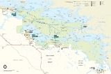
Voyageurs National Park
Encyclopedia
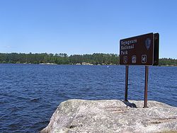
Voyageurs National Park is a United States
National Park
in northern Minnesota
near the town of International Falls
. It was established in 1975. The park's name commemorates the voyageurs
, French-Canadian fur trade
rs who were the first Europe
an settlers to frequently travel through the area. The park is notable for its outstanding water resources and is popular with canoe
ists, kayak
ers, other boaters and fishermen. The Kabetogama Peninsula, which lies entirely within the park and makes up most of its land area, is accessible only by boat. To the east of the National Park lies the Boundary Waters Canoe Area Wilderness
.
The park has several boat ramps and visitor centers around its periphery, though the main body of the park is only accessible by boat or, in the winter, by snowmobile
, ski
, or snowshoe
. The park hosts about 235,000 visitors per year. 114000 acres (461 km²) of the park are intended to be wilderness by September 30, 2006.
 The largest city near Voyageurs National Park is International Falls, Minnesota
. Unlike many other National Parks, where the main access to the park is by automobile or by foot, the primary access to the park is via water. Many visitors travel by canoe and kayak. Others rent house boats. The park has three centers where visitors can obtain information about the park, view films, and see exhibits about the park's geology, wildlife, plants, and history.
 Four major lakes are contained in or border the park. Lake Kabetogama, Lake Namakan, Rainy Lake
, and Sand Point Lake. The southern boundary of the park is the northern shore of Crane Lake. Of these, Namakan, Rainy and Sand Point lakes straddle the United States-Canada border. Lake Namakan and Sand Point Lake are accessible only by boat except in the winter. Lots of minor lakes dot the park, especially on the Kabetogama peninsula. Most popular of these are on the Locator Lakes trail. In all the park has more than 344 square miles (891 km²) of water.
.jpg) Campsites are maintained by the National Park Service
Campsites are maintained by the National Park Service
and are accessible only by water. The 175 sites are classified as tent, houseboat, or day-use sites; all are designated by signs. Tenters may not camp in houseboat sites or day-use sites. Maps showing the location of these sites are available at the visitor centers. Permits are required for overnight stays. Permits can be obtained at any park visitor center or boat ramp. Public and private campgrounds, accessible by car, are located near the perimeter of the park.
, Northern pike
, Muskellunge
, Smallmouth bass
, and Crappie
. In the minor lakes that dot the park, Largemouth bass
, Lake trout
, Bluegill
and other small sunfish and Yellow Perch
are also found, although not every lake has every species. For example, Lake Trout are found primarily in Cruiser Lake north of Kettle Falls. Shoepack and Root (Little Shoepack) lakes in the center of the park's peninsula are home to the Shoepack strain of Muskellunge
, distinctly different from the Mississippi strain (or Leech Lake strain) found throughout southern Minnesota and Wisconsin. Lake Whitefish
are also a popular quarry via sport netting in the fall when they move into shallow water to spawn.
.jpg) The park is snow covered from late December until early March. Available activities include snowmobiling, cross-country skiing, winter camping, ice fishing and snowshoe hiking. Snowmobiling is limited to the frozen lake surfaces and the Chain of Lakes Scenic Trail through the center of the Kabetogama Peninsula. Trail maps should be used and can be obtained from the visitor centers.
The park is snow covered from late December until early March. Available activities include snowmobiling, cross-country skiing, winter camping, ice fishing and snowshoe hiking. Snowmobiling is limited to the frozen lake surfaces and the Chain of Lakes Scenic Trail through the center of the Kabetogama Peninsula. Trail maps should be used and can be obtained from the visitor centers.
The use of snowmobiles in Voyageurs National Park, like in Yellowstone
, is controversial, with opponents claiming they damage the natural beauty of the park and adversely affect wildlife.
Designated Snowmobile Trails
Rainy Lake Trail is 28 miles (45 km) long running from Black Bay (the Rainy Lake Visitor Center) to Kettle Falls. It runs along the northern shore of the Kabeogama Peninsula, running inside the off shore islands. As it nears Kettle Falls, it turns south up a deep bay and then overland to avoid the soft ice along the narrows.
The Kettle Falls Trail is 7.4 miles (12 km) runs overland along the narrows, avoiding the soft and fractured ice of the narrows, until reaching the western end of Namakan Lake.
The Rudder Bay Trail is a short connecting trail acround the north side of the westerm Namakan Lake and Voyageur narrows, to the Ash River Visitor Center. Here, it joins into the Voyageur Trail.
The Voyageur Trail is a multiple segmented trail, beginning near the Thunderbird Lodge on Sand Bay. From Black Bay (Rainy Lake Visitor Center), it is nearly 6 miles (10 km) long to the junction with the Chain of Lakes Trail on the Kabetogama Peninsula. An additional 3.5 miles (6 km) crossing the west end of Kabetogama Lake brings you into the Kabetogama community with a short 1 miles (2 km) or so drop around the point to the Kabetogama Visitor Center. In the Kabetogama community, there are linkes to the Arrowhead Trail, Woody's Trail, Peterson Bay Trail, Tone Dawg Trail, and the Ray Access Spur.
After leaving the Kabetogama Visitor Center, the Voyageur Trail crosses the south side of Kabetogama Lake for 7 miles (11 km), to the Kabetogama Narrows (Ash River Visitor Center) and the Rudder Bay Trail. Another 3 miles (5 km) brings it to Ash River. In Ash River, there are links to other trails, including Bill Morgan Trail and the 'Ash River Links" to both the Arrowhead Trail and Crane Lake. By staying on the Voyageur Trail, you'll cross the southern shore of Namakan Lake and then turn south through Nakd Point Lake, Mukoda Lake and Crane Lake to Crane. This last link is 28 miles (45 km) long. The entire length of the Voyageur Trail is about 37 miles (60 km).
in a resolution requesting that the president create a national park in the state. It wasn't until nearly eighty years later that federal legislation authorizing the creation of the park was signed into law by President Richard Nixon
on January 8, 1971.
wintered along the Rainy River. But it was the demand for beaver pelts that brought the fur traders. As competition in the east depleted the beaver, the voyageurs
expanded their range into the northwest territories of North America. Here along the modern border of the United States and Canada, the Cree
, Monsoni, and Assiniboine tribes were first native American contacts. By the mid-18th century these people had abandoned the Rainy Lake area, to the Ojibwe. By 1780 the Ojibwe were the primary residents on the border. They filled key roles as suppliers of food, furs, and canoes.
in Michigan
, Wisconsin
and central Minnesota
were harvested. Beginning in the 1880s and 1890s, logging grew until there were two major logging companies. The International Logging Company in Koochiching County
used sawmills at International Falls and Fort Frances until 1937. It was the constant need for water that caused the dams to be constructed at International Falls, Kettle Falls, and Squirrel Falls in the early 1900s. The Virginia and Rainy Lake Lumber Company harvested trees to the east in St. Louis County
. They rafted logs down river to Hoist Bay until 1929. Hoist Bay is named for the machinery used to 'hoist' floating logs out of the lake. Trains then taken to sawmills in Virginia, Minnesota
. The logging has altered the composition of the forest. Where white and red pine once dominated the forest, they are a minor part. Few stands of large, mature trees exist in the park
to obtain title to the island. In the spring of 1894, development of the mine and of the nearby Rainy Lake City began. Rainy Lake City was incorporated on March 17, 1894. By summer the city was a community of several hundred people. It had a school house, bank, general store, hotels, restaurants, a newspaper, hardware store, butcher shop, and several saloons. With the development of the Little American Mine, other prospectors entered into the search. Mining remains which can still be seen include those of the Lyle Mine north of Dryweed Island, the Big American Mine on Big American Island, the Bushyhead Mine on Bushyhead Island, and the Soldier Mine on Dryweed Island. The low production from the mines ended the rush with a bust by 1898. The town of Rainy Lake City was gone by 1901.
. Most fell by the wayside as long distances and a lack of refrigeration affected the industry. By the 1930s all the large operations were gone.
Family fishing replaced the large operations. By 1910 there were around 48 family business'. The catch was sold at local auctions held at Kettle Falls. By 1923, commercial fishing was banned on Kabetogama Lake. By 1942 only 10 licensed family operations were active. Old fishing camps and net-tarring sites still exist in the park. The best preserved is the Oveson Fish Camp (c. 1950s).
Kettle Falls is located between Lake Namakan and Rainy Lake, and is the location of the Kettle Falls Hotel. The hotel was constructed in 1910 by timber baron Ed Rose and operated as a hotel and resort to this day. It was placed on the National Register of Historic Places
in 1976. Kettle Falls can only be reached by boat in the summer months and is one of the few places in the lower forty-eight states where one looks south into Canada.
Anderson Bay
Anderson Bay is a fine example of why the park was established. The bluffs of the Bay rise 80 feet (24.4 m) above the water. From the top, there are views of the bay and Rainy Lake. Anderson Bay is the northern trailhead for the Cruiser Lake Trail system. From the landing, a loop trail goes to the top of the bluffs. Anderson Bay is two-thirds of the way from Rainy Lake Visitor Center to Kettle Point. It is on the north side of the Kabetogama Peninsula.
Surveyor’s Island
Surveyor’s Island is a on the east end of Rainy Lake marking the entry to the American Channel to Kettle Falls. Here the boundary surveyors had a campsite during the early 1900s. Voyageurs would use this island as a stop before they entered the open waters of Rainy Lake.
Camp Marston
Camp Marston was Iowa State University operated a summer camp from 1922 until 1940. Civil engineering students would attend the camp. Today there is still a cabin known as “Polaris,” where the professors lived and foundations and chimneys from other structures.
Rainy Lake City
Rainy Lake City was a boom town in the 1890s during a short gold rush period. The site has a longer history of use than just the gold rush. A saloon still stands and is proposed as a shelter for exhibits. Former streets and archeological remains of buildings can be seen. Rainy Lake City is the northwestern point of the Kabetogama Peninsula facing Little American Island and the mainland.
Harry Oveson Fish Camp
Oveson’s fish camp is an intact commercial fishing camp. There are still several structures, including Oveson house, ice house, and fish processing building.
Little American Island
Little American Island is on Rainy Lake just north of the mainland. It is the furthest western island in the park. It was the site of gold discovery in 1893. The island has been upgraded to provide an accessible trail, a comfort station and dock.
.jpg) Ellsworth Rock Gardens
Ellsworth Rock Gardens
The Gardens was an enchanting sculpture once filled with flowers. Mr. Ellsworth created his garden as a part of the families summer home. Boat tours from Kabetogama Visitor Center visit this site on the northern shore of Lake Kabetogama.
Hacksaw Pass
Here, you can visit several wetlands, the Gold Portage, Woodenfrog family residence and other sites related to Ojibwe history.
Hoist Bay has been an area of logging and seasonal recreation. You can spot piers of the former railroad trestle, and buildings from, the resort era. The area is set up for day use. The bay is located on the southern shore of Namakan Lake, east of Ash River and the visitor center.
Moose River Indian Village
Moose River, enters Moose Bay, west of Hoist Bay. The Bois Forte Ojibwe once occupied the area from the 1760s through the 1930s. They lived in the area of the park until the Nett Lake reservation
was established. Five bands lived throughout the park, including the west end of Kabetogama Lake, Kettle Falls, Black Bay on Rainy Lake, Crane Lake, and Moose River of Namakan Lake.
I.W.Stevens Pine Cove Resort
The I.W.Stevens Pine Cove Resort represents the resort recreation period. The site’s historic buildings are set among large scenic pine trees. The site consists of I.W. Stevens’ home, a guest cabin, sauna, generator shed, and root cellar. I.W. Stevens acquired the property from the Virginia & Rainy Lake Lumber Company. The company chose not to cut the red pine on the site and many of the trees have reached a large, mature
state.
The Casareto Summer Cabin is an example of summer recreational cabins in the park. It is located on a sand beach.
Grassy Bay
Grassy Bay is a large western bay on Sand Point Lake. It is rich in natural and cultural resources. The cliffs are well-known among park visitors. The Mittet cabin is an example of early recreation (1880s- 1920s).
Ingersoll Estate
The Ingersoll lodge was built by Illinois philanthropist William Ingersoll in 1928. The estate is visible from the lake just north of Harrison Narrows.
Safe channels are marked in the main lakes by the U.S. Coast Guard. When upbound in the lakes, there are green numbered buoys that mark the 'left' or port
side of the channel. Red number buoys mark the 'right' or starboard side. Remember that it is the opposite when downbound. For Rainy Lake and Namakan Lake, upbound is going east. For Kabetegama Lake, upbound is going west. If you're on Sand Point Lake or Crane Lake, upbound is going south.
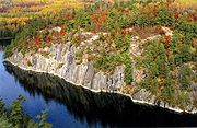
Hazardous rocks are common throughout the park and can lie just beneath the surface. Less than ten percent of these hazards are marked. Use care when traveling near shore and keep a watchful eye when on the open water. The park consists of parallel ridges of rock, which form the islands and the peninsula.
United States
The United States of America is a federal constitutional republic comprising fifty states and a federal district...
National Park
National park
A national park is a reserve of natural, semi-natural, or developed land that a sovereign state declares or owns. Although individual nations designate their own national parks differently A national park is a reserve of natural, semi-natural, or developed land that a sovereign state declares or...
in northern Minnesota
Minnesota
Minnesota is a U.S. state located in the Midwestern United States. The twelfth largest state of the U.S., it is the twenty-first most populous, with 5.3 million residents. Minnesota was carved out of the eastern half of the Minnesota Territory and admitted to the Union as the thirty-second state...
near the town of International Falls
International Falls, Minnesota
International Falls is a city in and the county seat of Koochiching County, Minnesota, United States. The population was 6,424 at the 2010 census....
. It was established in 1975. The park's name commemorates the voyageurs
Coureur des bois
A coureur des bois or coureur de bois was an independent entrepreneurial French-Canadian woodsman who traveled in New France and the interior of North America. They travelled in the woods to trade various things for fur....
, French-Canadian fur trade
Fur trade
The fur trade is a worldwide industry dealing in the acquisition and sale of animal fur. Since the establishment of world market for in the early modern period furs of boreal, polar and cold temperate mammalian animals have been the most valued...
rs who were the first Europe
Europe
Europe is, by convention, one of the world's seven continents. Comprising the westernmost peninsula of Eurasia, Europe is generally 'divided' from Asia to its east by the watershed divides of the Ural and Caucasus Mountains, the Ural River, the Caspian and Black Seas, and the waterways connecting...
an settlers to frequently travel through the area. The park is notable for its outstanding water resources and is popular with canoe
Canoe
A canoe or Canadian canoe is a small narrow boat, typically human-powered, though it may also be powered by sails or small electric or gas motors. Canoes are usually pointed at both bow and stern and are normally open on top, but can be decked over A canoe (North American English) or Canadian...
ists, kayak
Kayak
A kayak is a small, relatively narrow, human-powered boat primarily designed to be manually propelled by means of a double blade paddle.The traditional kayak has a covered deck and one or more cockpits, each seating one paddler...
ers, other boaters and fishermen. The Kabetogama Peninsula, which lies entirely within the park and makes up most of its land area, is accessible only by boat. To the east of the National Park lies the Boundary Waters Canoe Area Wilderness
Boundary Waters Canoe Area Wilderness
The Boundary Waters Canoe Area Wilderness , is a wilderness area within the Superior National Forest in northeastern Minnesota under the administration of the U.S. Forest Service...
.
The park has several boat ramps and visitor centers around its periphery, though the main body of the park is only accessible by boat or, in the winter, by snowmobile
Snowmobile
A snowmobile, also known in some places as a snowmachine, or sled,is a land vehicle for winter travel on snow. Designed to be operated on snow and ice, they require no road or trail. Design variations enable some machines to operate in deep snow or forests; most are used on open terrain, including...
, ski
Cross-country skiing
Cross-country skiing is a winter sport in which participants propel themselves across snow-covered terrain using skis and poles...
, or snowshoe
Snowshoe
A snowshoe is footwear for walking over the snow. Snowshoes work by distributing the weight of the person over a larger area so that the person's foot does not sink completely into the snow, a quality called "flotation"....
. The park hosts about 235,000 visitors per year. 114000 acres (461 km²) of the park are intended to be wilderness by September 30, 2006.
Geology
Voyageur National Park is located on the Canadian Shield, with the rocks averaging between 1 and 3 billion years old. Formed during the early ages of the earth formation, the rocks of the park were compressed, and folded under tremendous pressure. Then molten flows of lava intruded through the layers creating a mosaic of various gneiss and granites. Over time, additional layers of sedimentary rocks developed on top, to be stripped away by the continental glaciers of the Wisconsin Glacial epoch and earlier.Access
International Falls, Minnesota
International Falls is a city in and the county seat of Koochiching County, Minnesota, United States. The population was 6,424 at the 2010 census....
. Unlike many other National Parks, where the main access to the park is by automobile or by foot, the primary access to the park is via water. Many visitors travel by canoe and kayak. Others rent house boats. The park has three centers where visitors can obtain information about the park, view films, and see exhibits about the park's geology, wildlife, plants, and history.
- Rainy Lake Visitor Center - is open all year and is located 12 miles (19 km) east of International Falls at the end of Koochiching County Road 96, which is located off of State Highway 11Minnesota State Highway 11Minnesota State Highway 11 is a highway in northwest and north-central Minnesota, which runs from North Dakota Highway 66 at the North Dakota state line and continues east to its eastern terminus at the community of Island View at Rainy Lake, near International Falls.The route follows the Rainy...
, leaving International Falls. - Kabetogamma Lake Visitor Center - is located in the KabetogamaKabetogama, MinnesotaKabetogama is an unincorporated community in St. Louis County, Minnesota, United States.The community is located southeast of International Falls on County Road 122.U.S. Highway 53 is nearby.Kabetogama is located within Kabetogama Township.-Notes:...
community on the southwestern edge of the park. This center is open seasonally. It can be reached, just 3 miles (5 km) off of U.S. Highway 53U.S. Route 53U.S. Route 53 is a north–south U.S. highway that runs for 403 miles from La Crosse, Wisconsin to northern Minnesota. It is the primary north–south route in northwestern Wisconsin, serving as a vital link between I-94 at Eau Claire, Wisconsin and the city of Duluth, Minnesota...
on Saint Louis County Road 122 and Saint Louis County Road 123. - Ash River Visitor Center - is on the parks southern boundary just north of the community of Ash River. It can be reached, just 11 miles (18 km) from U.S. Highway 53U.S. Route 53U.S. Route 53 is a north–south U.S. highway that runs for 403 miles from La Crosse, Wisconsin to northern Minnesota. It is the primary north–south route in northwestern Wisconsin, serving as a vital link between I-94 at Eau Claire, Wisconsin and the city of Duluth, Minnesota...
on the Ash River Trail, Saint Louis County Road 129, taking the park road 1 miles (2 km) before reaching Ash River.
Waters
Rainy Lake
Rainy Lake is a relatively large freshwater lake that straddles the border between the United States and Canada. The Rainy River issues from the west side of the lake and is harnessed to make hydroelectricity for US and Canadian locations. The U.S...
, and Sand Point Lake. The southern boundary of the park is the northern shore of Crane Lake. Of these, Namakan, Rainy and Sand Point lakes straddle the United States-Canada border. Lake Namakan and Sand Point Lake are accessible only by boat except in the winter. Lots of minor lakes dot the park, especially on the Kabetogama peninsula. Most popular of these are on the Locator Lakes trail. In all the park has more than 344 square miles (891 km²) of water.
- Rainy Lake - 60 miles (97 km) long, 929 miles (1,495 km) of shoreline, 227604 acres (921.1 km²), 161 feet (49.1 m) max depth
- Kabetogama Lake - 15 miles (24 km) long, 78 miles (126 km) of shoreline, 25760 acres (104.2 km²), 80 feet (24.4 m) max depth
- Namakan Lake - 16 miles (26 km) long, 146 miles (235 km) of shoreline, 25130 acres (101.7 km²), 150 feet (45.7 m) max depth
- Sand Point Lake - 8 miles (13 km) long, 92 miles (148 km) of shoreline, 5179 acres (21 km²), 184 feet (56.1 m) max depth
Camping
National Park Service
The National Park Service is the U.S. federal agency that manages all national parks, many national monuments, and other conservation and historical properties with various title designations...
and are accessible only by water. The 175 sites are classified as tent, houseboat, or day-use sites; all are designated by signs. Tenters may not camp in houseboat sites or day-use sites. Maps showing the location of these sites are available at the visitor centers. Permits are required for overnight stays. Permits can be obtained at any park visitor center or boat ramp. Public and private campgrounds, accessible by car, are located near the perimeter of the park.
Fishing
The major lakes in the park are home to WalleyeWalleye
Walleye is a freshwater perciform fish native to most of Canada and to the northern United States. It is a North American close relative of the European pikeperch...
, Northern pike
Northern Pike
The northern pike , is a species of carnivorous fish of the genus Esox...
, Muskellunge
Muskellunge
A muskellunge , also known as a muskelunge, muscallonge, milliganong, or maskinonge , is a large, relatively uncommon freshwater fish of North America. Muskellunge are the largest member of the pike family, Esocidae...
, Smallmouth bass
Smallmouth bass
The smallmouth bass is a species of freshwater fish in the sunfish family of the order Perciformes. It is the type species of its genus...
, and Crappie
Crappie
Crappie is a genus of freshwater fish in the sunfish family of order Perciformes. The type species is P. annularis, the white crappie...
. In the minor lakes that dot the park, Largemouth bass
Largemouth bass
The largemouth bass is a species of black bass in the sunfish family native to North America . It is also known as widemouth bass, bigmouth, black bass, bucketmouth, Potter's fish, Florida bass, Florida largemouth, green bass, green trout, linesides, Oswego bass, southern largemouth...
, Lake trout
Lake trout
Lake trout is a freshwater char living mainly in lakes in northern North America. Other names for it include mackinaw, lake char , touladi, togue, and grey trout. In Lake Superior, they can also be variously known as siscowet, paperbellies and leans...
, Bluegill
Bluegill
The Bluegill is a species of freshwater fish sometimes referred to as bream, brim, or copper nose. It is a member of the sunfish family Centrarchidae of the order Perciformes.-Range and distribution:...
and other small sunfish and Yellow Perch
Yellow perch
The yellow perch is a species of perch found in the United States and Canada, where it is often referred to by the shortform perch. Yellow perch look similar to the European perch, but are paler and more yellowish, with less red in the fins. They have six to eight dark, vertical bars on their sides...
are also found, although not every lake has every species. For example, Lake Trout are found primarily in Cruiser Lake north of Kettle Falls. Shoepack and Root (Little Shoepack) lakes in the center of the park's peninsula are home to the Shoepack strain of Muskellunge
Muskellunge
A muskellunge , also known as a muskelunge, muscallonge, milliganong, or maskinonge , is a large, relatively uncommon freshwater fish of North America. Muskellunge are the largest member of the pike family, Esocidae...
, distinctly different from the Mississippi strain (or Leech Lake strain) found throughout southern Minnesota and Wisconsin. Lake Whitefish
Lake whitefish
The lake whitefish , also called the Sault whitefish or gizzard fish, is a species of freshwater whitefish from North America. Lake whitefish are found throughout much of Canada and parts of the northern United States, including all of the Great Lakes. A valuable commercial fish, they are also...
are also a popular quarry via sport netting in the fall when they move into shallow water to spawn.
Boating
Visitors are encouraged to take to the water by boat, and many explore the park's large lakes and islands with canoes, kayaks and motorboats. The park's interior peninsula is only accessible during summer by boat, and the park has a system of canoes and boats available for rental at interior lakes. During summer months, the park also offers shuttle service to an interior lake, as well as ranger-led boat tours that explore the park's natural features and history.Hiking
The park has over 50 miles (80.5 km) of hiking trails. While some trails are located on the mainland, the majority traverse the park's interior peninsula, including long-distance backcountry trails.In winter
The use of snowmobiles in Voyageurs National Park, like in Yellowstone
Yellowstone National Park
Yellowstone National Park, established by the U.S. Congress and signed into law by President Ulysses S. Grant on March 1, 1872, is a national park located primarily in the U.S. state of Wyoming, although it also extends into Montana and Idaho...
, is controversial, with opponents claiming they damage the natural beauty of the park and adversely affect wildlife.
Designated Snowmobile Trails
Rainy Lake Trail is 28 miles (45 km) long running from Black Bay (the Rainy Lake Visitor Center) to Kettle Falls. It runs along the northern shore of the Kabeogama Peninsula, running inside the off shore islands. As it nears Kettle Falls, it turns south up a deep bay and then overland to avoid the soft ice along the narrows.
The Kettle Falls Trail is 7.4 miles (12 km) runs overland along the narrows, avoiding the soft and fractured ice of the narrows, until reaching the western end of Namakan Lake.
The Rudder Bay Trail is a short connecting trail acround the north side of the westerm Namakan Lake and Voyageur narrows, to the Ash River Visitor Center. Here, it joins into the Voyageur Trail.
The Voyageur Trail is a multiple segmented trail, beginning near the Thunderbird Lodge on Sand Bay. From Black Bay (Rainy Lake Visitor Center), it is nearly 6 miles (10 km) long to the junction with the Chain of Lakes Trail on the Kabetogama Peninsula. An additional 3.5 miles (6 km) crossing the west end of Kabetogama Lake brings you into the Kabetogama community with a short 1 miles (2 km) or so drop around the point to the Kabetogama Visitor Center. In the Kabetogama community, there are linkes to the Arrowhead Trail, Woody's Trail, Peterson Bay Trail, Tone Dawg Trail, and the Ray Access Spur.
After leaving the Kabetogama Visitor Center, the Voyageur Trail crosses the south side of Kabetogama Lake for 7 miles (11 km), to the Kabetogama Narrows (Ash River Visitor Center) and the Rudder Bay Trail. Another 3 miles (5 km) brings it to Ash River. In Ash River, there are links to other trails, including Bill Morgan Trail and the 'Ash River Links" to both the Arrowhead Trail and Crane Lake. By staying on the Voyageur Trail, you'll cross the southern shore of Namakan Lake and then turn south through Nakd Point Lake, Mukoda Lake and Crane Lake to Crane. This last link is 28 miles (45 km) long. The entire length of the Voyageur Trail is about 37 miles (60 km).
History
The park was first proposed in April 1891 by the Minnesota LegislatureMinnesota Legislature
The Minnesota Legislature is the legislative branch of government in the U.S. state of Minnesota. It is a bicameral legislature located at the Minnesota Capitol in Saint Paul and it consists of two houses: the lower Minnesota House of Representatives and the Minnesota Senate...
in a resolution requesting that the president create a national park in the state. It wasn't until nearly eighty years later that federal legislation authorizing the creation of the park was signed into law by President Richard Nixon
Richard Nixon
Richard Milhous Nixon was the 37th President of the United States, serving from 1969 to 1974. The only president to resign the office, Nixon had previously served as a US representative and senator from California and as the 36th Vice President of the United States from 1953 to 1961 under...
on January 8, 1971.
First People
Voyageurs National Park has been occupied by man for nearly 10,000 years. During the Paleo-Indian Period, people entered this area as the waters from glacial Lake Agassiz receded. Then during the Archaic Period (8,000 B.C. - 100 B.C.) nomadic people move with the animals they hunted and with the ripening grains. Fishing grew into a major source of food during this time. The Woodland Period (100 A.D.- 900 A.D.) saw an increase in the use of the wild rice. Beginning around this time, ceramics began to appear. Also, small, side-notched triangular projectile pointsThe Fur Trade
European exploration began about 1688. French explorer Jacques de NoyonJacques de Noyon
Jacques de Noyon was a French Canadian explorer and coureur des bois. He is the first known European to visit the Boundary Waters region west of Lake Superior.Jacques de Noyon was born on February 12, 1668, in Trois-Rivières, New France...
wintered along the Rainy River. But it was the demand for beaver pelts that brought the fur traders. As competition in the east depleted the beaver, the voyageurs
Voyageurs
The Voyageurs were the persons who engaged in the transportation of furs by canoe during the fur trade era. Voyageur is a French word which literally translates to "traveler"...
expanded their range into the northwest territories of North America. Here along the modern border of the United States and Canada, the Cree
Cree
The Cree are one of the largest groups of First Nations / Native Americans in North America, with 200,000 members living in Canada. In Canada, the major proportion of Cree live north and west of Lake Superior, in Ontario, Manitoba, Saskatchewan, Alberta and the Northwest Territories, although...
, Monsoni, and Assiniboine tribes were first native American contacts. By the mid-18th century these people had abandoned the Rainy Lake area, to the Ojibwe. By 1780 the Ojibwe were the primary residents on the border. They filled key roles as suppliers of food, furs, and canoes.
Logging
Logging came to the northwoods as the stands of white pineEastern White Pine
Pinus strobus, commonly known as the eastern white pine, is a large pine native to eastern North America, occurring from Newfoundland west to Minnesota and southeastern Manitoba, and south along the Appalachian Mountains to the northern edge of Georgia.It is occasionally known as simply white pine,...
in Michigan
Michigan
Michigan is a U.S. state located in the Great Lakes Region of the United States of America. The name Michigan is the French form of the Ojibwa word mishigamaa, meaning "large water" or "large lake"....
, Wisconsin
Wisconsin
Wisconsin is a U.S. state located in the north-central United States and is part of the Midwest. It is bordered by Minnesota to the west, Iowa to the southwest, Illinois to the south, Lake Michigan to the east, Michigan to the northeast, and Lake Superior to the north. Wisconsin's capital is...
and central Minnesota
Minnesota
Minnesota is a U.S. state located in the Midwestern United States. The twelfth largest state of the U.S., it is the twenty-first most populous, with 5.3 million residents. Minnesota was carved out of the eastern half of the Minnesota Territory and admitted to the Union as the thirty-second state...
were harvested. Beginning in the 1880s and 1890s, logging grew until there were two major logging companies. The International Logging Company in Koochiching County
Koochiching County, Minnesota
Koochiching County is a county located in the U.S. state of Minnesota. As of 2010, the population was 13,311. Its county seat is International Falls. A portion of the Bois Forte Indian Reservation is in the county. A small part of Voyageurs National Park extends into its northeast...
used sawmills at International Falls and Fort Frances until 1937. It was the constant need for water that caused the dams to be constructed at International Falls, Kettle Falls, and Squirrel Falls in the early 1900s. The Virginia and Rainy Lake Lumber Company harvested trees to the east in St. Louis County
St. Louis County, Minnesota
St. Louis County is a county located in the U.S. state of Minnesota. As of 2010, the population was 200,226. Its county seat is Duluth. It is the largest county by total area in Minnesota, and the second largest in the United States east of the Mississippi River; in land area alone, after Aroostook...
. They rafted logs down river to Hoist Bay until 1929. Hoist Bay is named for the machinery used to 'hoist' floating logs out of the lake. Trains then taken to sawmills in Virginia, Minnesota
Virginia, Minnesota
As of the census of 2000, there were 9,157 people, 4,333 households, and 2,270 families residing in the city. The population density was 486.1 people per square mile . There were 4,692 housing units at an average density of 249.1 per square mile...
. The logging has altered the composition of the forest. Where white and red pine once dominated the forest, they are a minor part. Few stands of large, mature trees exist in the park
The Rainy Lake Gold Rush
In the summer of 1893 George Davis, funded by Charles Moore, discovered gold on Rainy Lake. Davis was on a small island near Black Bay Narrows. Here, he found a gold-bearing quartz vein. The "Little American" discovery gave rise to the islands modern name, Little American Island. With confirmation of the discovery, Charles Moore hired Jeff Hildreth, a miner from the Black HillsBlack Hills
The Black Hills are a small, isolated mountain range rising from the Great Plains of North America in western South Dakota and extending into Wyoming, USA. Set off from the main body of the Rocky Mountains, the region is something of a geological anomaly—accurately described as an "island of...
to obtain title to the island. In the spring of 1894, development of the mine and of the nearby Rainy Lake City began. Rainy Lake City was incorporated on March 17, 1894. By summer the city was a community of several hundred people. It had a school house, bank, general store, hotels, restaurants, a newspaper, hardware store, butcher shop, and several saloons. With the development of the Little American Mine, other prospectors entered into the search. Mining remains which can still be seen include those of the Lyle Mine north of Dryweed Island, the Big American Mine on Big American Island, the Bushyhead Mine on Bushyhead Island, and the Soldier Mine on Dryweed Island. The low production from the mines ended the rush with a bust by 1898. The town of Rainy Lake City was gone by 1901.
Settlement and Recreation
When the park was established in 1975, there were over 60 resorts around the park. Within the park, there were 12 resorts, 97 leased cabin sites, and over 120 privately owned recreational homes. Many sold their land and buildings to the park. Some people chose to sell their property and leave immediately, while others chose to sell their property, but maintain use for either a lifetime tenancy or a 25-year use and occupancy reservation. As these properties are vacated, the park will remove many structures to restore natural conditions. Twenty properties, containing over 50 structures, will be retained and managed by the National Park Service because of their historic significance.Commercial Fishing
Large fishing operations began on the Rainy River in 1892. By the 1890s and early 1900s, seven or eight fishing companies operated in the area. Most were down on Crane Lake. The main production was caviar, taken from the eggs of lake sturgeonLake sturgeon
The lake sturgeon is a North American temperate freshwater fish, one of about 20 species of sturgeon. Like other sturgeons, this species is an evolutionarily ancient bottomfeeder with a partly cartilaginous skeleton and skin bearing rows of bony plates...
. Most fell by the wayside as long distances and a lack of refrigeration affected the industry. By the 1930s all the large operations were gone.
Family fishing replaced the large operations. By 1910 there were around 48 family business'. The catch was sold at local auctions held at Kettle Falls. By 1923, commercial fishing was banned on Kabetogama Lake. By 1942 only 10 licensed family operations were active. Old fishing camps and net-tarring sites still exist in the park. The best preserved is the Oveson Fish Camp (c. 1950s).
Rainy Lake Sites
Kettle Falls HotelKettle Falls Hotel
The Kettle Falls Hotel is a hotel that was built beginning in 1910 in what is now Voyageurs National Park on the Kabetogama Peninsula, at the juncture of Namakan and Rainy Lakes. The hotel was built to replace temporary lodgings, accommodating dam workers, loggers and tourists, and was finally...
Kettle Falls is located between Lake Namakan and Rainy Lake, and is the location of the Kettle Falls Hotel. The hotel was constructed in 1910 by timber baron Ed Rose and operated as a hotel and resort to this day. It was placed on the National Register of Historic Places
National Register of Historic Places
The National Register of Historic Places is the United States government's official list of districts, sites, buildings, structures, and objects deemed worthy of preservation...
in 1976. Kettle Falls can only be reached by boat in the summer months and is one of the few places in the lower forty-eight states where one looks south into Canada.
Anderson Bay
Anderson Bay is a fine example of why the park was established. The bluffs of the Bay rise 80 feet (24.4 m) above the water. From the top, there are views of the bay and Rainy Lake. Anderson Bay is the northern trailhead for the Cruiser Lake Trail system. From the landing, a loop trail goes to the top of the bluffs. Anderson Bay is two-thirds of the way from Rainy Lake Visitor Center to Kettle Point. It is on the north side of the Kabetogama Peninsula.
Surveyor’s Island
Surveyor’s Island is a on the east end of Rainy Lake marking the entry to the American Channel to Kettle Falls. Here the boundary surveyors had a campsite during the early 1900s. Voyageurs would use this island as a stop before they entered the open waters of Rainy Lake.
Camp Marston
Camp Marston was Iowa State University operated a summer camp from 1922 until 1940. Civil engineering students would attend the camp. Today there is still a cabin known as “Polaris,” where the professors lived and foundations and chimneys from other structures.
Rainy Lake City
Rainy Lake City was a boom town in the 1890s during a short gold rush period. The site has a longer history of use than just the gold rush. A saloon still stands and is proposed as a shelter for exhibits. Former streets and archeological remains of buildings can be seen. Rainy Lake City is the northwestern point of the Kabetogama Peninsula facing Little American Island and the mainland.
Harry Oveson Fish Camp
Oveson’s fish camp is an intact commercial fishing camp. There are still several structures, including Oveson house, ice house, and fish processing building.
Little American Island
Little American Island is on Rainy Lake just north of the mainland. It is the furthest western island in the park. It was the site of gold discovery in 1893. The island has been upgraded to provide an accessible trail, a comfort station and dock.
Kabetogama Lake Sites
The Gardens was an enchanting sculpture once filled with flowers. Mr. Ellsworth created his garden as a part of the families summer home. Boat tours from Kabetogama Visitor Center visit this site on the northern shore of Lake Kabetogama.
Hacksaw Pass
Here, you can visit several wetlands, the Gold Portage, Woodenfrog family residence and other sites related to Ojibwe history.
Namakan Lake Sites
Hoist BayHoist Bay has been an area of logging and seasonal recreation. You can spot piers of the former railroad trestle, and buildings from, the resort era. The area is set up for day use. The bay is located on the southern shore of Namakan Lake, east of Ash River and the visitor center.
Moose River Indian Village
Moose River, enters Moose Bay, west of Hoist Bay. The Bois Forte Ojibwe once occupied the area from the 1760s through the 1930s. They lived in the area of the park until the Nett Lake reservation
Bois Forte Indian Reservation
Bois Forte Indian Reservation is an Indian reservation formed for the Bois Forte Band of Chippewa...
was established. Five bands lived throughout the park, including the west end of Kabetogama Lake, Kettle Falls, Black Bay on Rainy Lake, Crane Lake, and Moose River of Namakan Lake.
I.W.Stevens Pine Cove Resort
The I.W.Stevens Pine Cove Resort represents the resort recreation period. The site’s historic buildings are set among large scenic pine trees. The site consists of I.W. Stevens’ home, a guest cabin, sauna, generator shed, and root cellar. I.W. Stevens acquired the property from the Virginia & Rainy Lake Lumber Company. The company chose not to cut the red pine on the site and many of the trees have reached a large, mature
state.
Sand Point/Crane Lake
Casareto Summer CabinThe Casareto Summer Cabin is an example of summer recreational cabins in the park. It is located on a sand beach.
Grassy Bay
Grassy Bay is a large western bay on Sand Point Lake. It is rich in natural and cultural resources. The cliffs are well-known among park visitors. The Mittet cabin is an example of early recreation (1880s- 1920s).
Ingersoll Estate
The Ingersoll lodge was built by Illinois philanthropist William Ingersoll in 1928. The estate is visible from the lake just north of Harrison Narrows.
Weather
Boating Safety
Voyageurs Nat'l Park is a water based park. Therefore, there are numerous safety issues that need to be observed. Never travel in the park without a navigation map.Safe channels are marked in the main lakes by the U.S. Coast Guard. When upbound in the lakes, there are green numbered buoys that mark the 'left' or port
Port
A port is a location on a coast or shore containing one or more harbors where ships can dock and transfer people or cargo to or from land....
side of the channel. Red number buoys mark the 'right' or starboard side. Remember that it is the opposite when downbound. For Rainy Lake and Namakan Lake, upbound is going east. For Kabetegama Lake, upbound is going west. If you're on Sand Point Lake or Crane Lake, upbound is going south.
Hazardous rocks are common throughout the park and can lie just beneath the surface. Less than ten percent of these hazards are marked. Use care when traveling near shore and keep a watchful eye when on the open water. The park consists of parallel ridges of rock, which form the islands and the peninsula.
Winter
Snowmobiling is a major recreational activity during the winter months. It is best to obtain a trail map locally and to review the hazardous area marked on the map. In the heart of the season, the most hazardous areas, are along the river channels. Places like Rainy River or any of the narrows. The current under the ice causes pressure ridges and soft spots. Avoid these areas.See also
- Grand Portage National MonumentGrand Portage National MonumentGrand Portage National Monument is a United States National Monument located on the north shore of Lake Superior in northeastern Minnesota that preserves a vital center of fur trade activity and Anishinaabeg Ojibwe heritage....
, historic Voyageur site - Fur tradeFur tradeThe fur trade is a worldwide industry dealing in the acquisition and sale of animal fur. Since the establishment of world market for in the early modern period furs of boreal, polar and cold temperate mammalian animals have been the most valued...
- Fort BeauharnoisFort BeauharnoisFort Beauharnois was a French fort built on the shores of Lake Pepin, a wide part of the upper Mississippi River, in 1727. The location chosen was on lowlands and the fort was rebuilt in 1730 on higher ground. It was the site of the first Roman Catholic chapel in Minnesota, which was dedicated to...
, French trading post - Fort St. CharlesFort St. CharlesFort Saint Charles was a secure trading post constructed in 1732, one of several western forts built under the direction of military commander La Vérendrye...
, French trading fort on the ManitobaManitobaManitoba is a Canadian prairie province with an area of . The province has over 110,000 lakes and has a largely continental climate because of its flat topography. Agriculture, mostly concentrated in the fertile southern and western parts of the province, is vital to the province's economy; other...
and MinnesotaMinnesotaMinnesota is a U.S. state located in the Midwestern United States. The twelfth largest state of the U.S., it is the twenty-first most populous, with 5.3 million residents. Minnesota was carved out of the eastern half of the Minnesota Territory and admitted to the Union as the thirty-second state...
border - Fort St. PierreFort St. PierreFort Saint Pierre was the first fort built west of Fort Kaministiquia by Pierre La Vérendrye in northwestern Ontario. La Vérendrye, the first western commander, built it in 1731 at the beginning of his explorations. As military officer, La Vérendrye had multiple responsibilities, and he created...
, trading post built by La Vérendrye on Rainy Lake - Fort KaministiquiaFort KaministiquiaFort Camanistigoyan, now standardized as Fort Kaministiquia, located at the mouth of the Kaministiquia River on Lake Superior in what is now northwestern Ontario, Canada, was established in 1717 by Zacharie Robutel de la Noue following the restoration of the system of trading permits by...
, French and English post on Lake Superior - Lake of the WoodsLake of the WoodsLake of the Woods is a lake occupying parts of the Canadian provinces of Ontario and Manitoba and the U.S. state of Minnesota. It separates a small land area of Minnesota from the rest of the United States. The Northwest Angle and the town of Angle Township can only be reached from the rest of...
- North American fur tradeNorth American Fur TradeThe North American fur trade was the industry and activities related to the acquisition, exchange, and sale of animal furs in the North American continent. Indigenous peoples of different regions traded among themselves in the Pre-Columbian Era, but Europeans participated in the trade beginning...
External links
- National Park Service: Voyageurs National Park
- Voyageurs National Park Association
- Voyageurs National Park at NASA Earth ObservatoryNASA Earth ObservatoryNASA Earth Observatory is an online publishing outlet for NASA which was created in 1999. It is the principal source of satellite imagery and other scientific information pertaining to the climate and the environment which are being provided by NASA for consumption by the general public...
- Minnesota DNR Lakefinder