
Southwest National Park
Encyclopedia
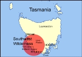
The Southwest National Park is a 618267 hectares (1,527,769.7 acre) national park located in the south-west
of Tasmania
, Australia
. The park is Tasmania's largest and forms part of the Tasmanian Wilderness
World Heritage Area
.
The eastern boundary is 93 kilometres (57.8 mi) west of Hobart and the park stretches to the west and south coasts. This park comprises the bulk of Tasmania's South West Wilderness
.
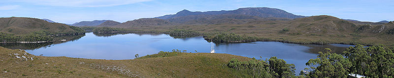
The park is well known for its pristine wilderness and remoteness. Weather in the park is highly changeable, and can be severe. The area is largely unaffected by humans. Although evidence shows Tasmanian Aborigines
have visited the area for at least 25,000 years, and European settlers have made occasional forays into the park area since the 19th century, there has been very little permanent habitation and only minimal impact on the natural environment. Within the area there is only one road, to the hydroelectricity
township of Strathgordon
. The southern and western reaches of the park are far removed from any vehicular access. The only access is by foot, boat, or light aircraft.
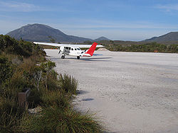
The tiny locality of Melaleuca
in the extreme south-west provides an airstrip and some very basic facilities, mainly to do with the National Parks Service.
area is the summer breeding grounds of the highly endangered orange-bellied parrot
.
to the hydroelectricity
township of Strathgordon
and the Cockle Creek route via the Huon Highway
. The southern and western reaches of the park are far removed from any vehicular access. The only access is by foot, boat, or light aircraft.
Two main walking tracks cross the park: the Port Davey Track
, south from Lake Pedder
and the South Coast Track, east from Cockle Creek, the other west from Cockle Creek
along Tasmania's south-coast to Melaleuca
. The walks are generally for more experienced walkers, taking approximately ten to fourteen days to complete the full route. Alternatively a flight to or from Melaleuca
may be arranged to split the walk, or for tourist access for day trips. Several more difficult walks also exist, encompassing the Eastern and Western Arthur Range
s, Precipitous Bluff, the South West Cape, and Federation Peak
. Many of these latter routes are not recommended for inexperienced walkers, or for people traveling alone. Sea access to the region is best gained via Port Davey and Bathurst Harbour
.
South West Tasmania
South West Tasmania is a region in Tasmania that has evolved over the fifty years between its consideration as a potential resource for development to its consideration as World Heritage wilderness...
of Tasmania
Tasmania
Tasmania is an Australian island and state. It is south of the continent, separated by Bass Strait. The state includes the island of Tasmania—the 26th largest island in the world—and the surrounding islands. The state has a population of 507,626 , of whom almost half reside in the greater Hobart...
, Australia
Australia
Australia , officially the Commonwealth of Australia, is a country in the Southern Hemisphere comprising the mainland of the Australian continent, the island of Tasmania, and numerous smaller islands in the Indian and Pacific Oceans. It is the world's sixth-largest country by total area...
. The park is Tasmania's largest and forms part of the Tasmanian Wilderness
Tasmanian Wilderness
The Tasmanian Wilderness is a term that is used for a range of areas in Tasmania, Australia.The World Heritage Areas in South West, Western and Central are the most well known. However, there are also other areas in Tasmania that have the elements of being known as wilderness areas, the Tarkine...
World Heritage Area
World Heritage Site
A UNESCO World Heritage Site is a place that is listed by the UNESCO as of special cultural or physical significance...
.
The eastern boundary is 93 kilometres (57.8 mi) west of Hobart and the park stretches to the west and south coasts. This park comprises the bulk of Tasmania's South West Wilderness
South West Wilderness, Tasmania
The South West Wilderness of Tasmania, Australia is a remote and inaccessible corner of the island state containing unspoilt scenery, rugged peaks, wild rivers, unique flora and fauna, and a long and rugged coastline...
.
The park is well known for its pristine wilderness and remoteness. Weather in the park is highly changeable, and can be severe. The area is largely unaffected by humans. Although evidence shows Tasmanian Aborigines
Tasmanian Aborigines
The Tasmanian Aborigines were the indigenous people of the island state of Tasmania, Australia. Before British colonisation in 1803, there were an estimated 3,000–15,000 Parlevar. A number of historians point to introduced disease as the major cause of the destruction of the full-blooded...
have visited the area for at least 25,000 years, and European settlers have made occasional forays into the park area since the 19th century, there has been very little permanent habitation and only minimal impact on the natural environment. Within the area there is only one road, to the hydroelectricity
Hydroelectricity
Hydroelectricity is the term referring to electricity generated by hydropower; the production of electrical power through the use of the gravitational force of falling or flowing water. It is the most widely used form of renewable energy...
township of Strathgordon
Strathgordon, Tasmania
Strathgordon is a locality in Tasmania, Australia at the end of the Gordon River Road, the most south westerly road in the south west of Tasmania.It is remote by Tasmanian standards with the nearest basic services away along a winding road at Maydena....
. The southern and western reaches of the park are far removed from any vehicular access. The only access is by foot, boat, or light aircraft.
The tiny locality of Melaleuca
Melaleuca, Tasmania
Melaleuca is a remote hamlet in the south-west area of Tasmania, Australia. Access is only by sea via Port Davey, by air or by foot.The settlement consists of a couple of buildings and a bird hide where the Orange-bellied Parrot can be viewed, and is a major tourist attraction...
in the extreme south-west provides an airstrip and some very basic facilities, mainly to do with the National Parks Service.
History
The core of the park was created in 1955 and was originally called Lake Pedder National Park. Over the following 35 years the park was gradually extended and renamed, finally reaching its present size in 1990.Wildlife
The MelaleucaMelaleuca, Tasmania
Melaleuca is a remote hamlet in the south-west area of Tasmania, Australia. Access is only by sea via Port Davey, by air or by foot.The settlement consists of a couple of buildings and a bird hide where the Orange-bellied Parrot can be viewed, and is a major tourist attraction...
area is the summer breeding grounds of the highly endangered orange-bellied parrot
Orange-bellied Parrot
The Orange-bellied Parrot is a small broad-tailed parrot endemic to southern Australia, and one of only two species of parrot which migrate. The adult male is distinguished by its bright grass-green upperparts, yellow underparts and orange belly patch. The adult female and juvenile are duller...
.
Access and recreation
There are two ways to access the park: the Gordon River RoadGordon River Road
- was a road built to service the Hydro Tasmania construction of the Gordon Dam, and the Serpentine Dam, Tasmania leading to the flooding of Lake Pedder in South West Tasmania....
to the hydroelectricity
Hydroelectricity
Hydroelectricity is the term referring to electricity generated by hydropower; the production of electrical power through the use of the gravitational force of falling or flowing water. It is the most widely used form of renewable energy...
township of Strathgordon
Strathgordon, Tasmania
Strathgordon is a locality in Tasmania, Australia at the end of the Gordon River Road, the most south westerly road in the south west of Tasmania.It is remote by Tasmanian standards with the nearest basic services away along a winding road at Maydena....
and the Cockle Creek route via the Huon Highway
Huon Highway
The Huon Highway is an highway in southern Tasmania, Australia. The highway forms part of the and connects Hobart with the southern parts of Tasmania. The original Huon Highway was a twisty two-lane road skirting around Mount Wellington, but that section of the Highway was bypassed in stages...
. The southern and western reaches of the park are far removed from any vehicular access. The only access is by foot, boat, or light aircraft.
Two main walking tracks cross the park: the Port Davey Track
Port Davey Track
The Port Davey track in the South Coast Tasmania region is a bushwalking track in the Southwest National Park of Tasmania, Australia.The Port Davey track starts or ends at Melaleuca and runs for 65km north to the Scotts Peak Road...
, south from Lake Pedder
Lake Pedder
Lake Pedder was once a natural lake, located in the southwest of Tasmania, Australia but the name is now used in an official sense to refer to the much larger artificial impoundment and diversion lake formed when the original lake was expanded by damming in 1972 by the Hydro Electric Commission of...
and the South Coast Track, east from Cockle Creek, the other west from Cockle Creek
Cockle Creek, Tasmania
Cockle Creek is a tiny settlement in Tasmania, the farthest point south one can drive in Australia, 148 km from Hobart via the Huon Highway...
along Tasmania's south-coast to Melaleuca
Melaleuca, Tasmania
Melaleuca is a remote hamlet in the south-west area of Tasmania, Australia. Access is only by sea via Port Davey, by air or by foot.The settlement consists of a couple of buildings and a bird hide where the Orange-bellied Parrot can be viewed, and is a major tourist attraction...
. The walks are generally for more experienced walkers, taking approximately ten to fourteen days to complete the full route. Alternatively a flight to or from Melaleuca
Melaleuca, Tasmania
Melaleuca is a remote hamlet in the south-west area of Tasmania, Australia. Access is only by sea via Port Davey, by air or by foot.The settlement consists of a couple of buildings and a bird hide where the Orange-bellied Parrot can be viewed, and is a major tourist attraction...
may be arranged to split the walk, or for tourist access for day trips. Several more difficult walks also exist, encompassing the Eastern and Western Arthur Range
Arthur Range
The Arthur Range is a mountain range in the South West Wilderness, Tasmania, Australia. The range is broken into two main section, the Western Arthurs and the Eastern Arthurs...
s, Precipitous Bluff, the South West Cape, and Federation Peak
Federation Peak
Federation Peak is a prominent mountain located in the Southwest National Park of Tasmania, Australia. The peak, 90 km from Hobart, was named after the Federation of Australia and is often described as one of the hardest Bushwalking challenges in Australia.-History:The first westerner to...
. Many of these latter routes are not recommended for inexperienced walkers, or for people traveling alone. Sea access to the region is best gained via Port Davey and Bathurst Harbour
Bathurst Harbour
Bathurst Harbour is located in the South West Wilderness of Tasmania. It is a safe anchorage from the Roaring Forties that buffet the Western and South Coast Tasmania...
.
See also
- Orange-bellied ParrotOrange-bellied ParrotThe Orange-bellied Parrot is a small broad-tailed parrot endemic to southern Australia, and one of only two species of parrot which migrate. The adult male is distinguished by its bright grass-green upperparts, yellow underparts and orange belly patch. The adult female and juvenile are duller...
- Protected areas of Tasmania (Australia)
- South West WildernessSouth West Wilderness, TasmaniaThe South West Wilderness of Tasmania, Australia is a remote and inaccessible corner of the island state containing unspoilt scenery, rugged peaks, wild rivers, unique flora and fauna, and a long and rugged coastline...
- South East Mutton Bird IsletSouth East Mutton Bird IsletSouth East Mutton Bird Islet is a steep islet, with an area of 0.52 ha, in south-eastern Australia. Its highest point is 22 m asl. It is part of the Mutton Bird Island Group, lying close to the southern end of the south-western coast of Tasmania. It is also part of the Southwest National Park,...
- MelaleucaMelaleuca, TasmaniaMelaleuca is a remote hamlet in the south-west area of Tasmania, Australia. Access is only by sea via Port Davey, by air or by foot.The settlement consists of a couple of buildings and a bird hide where the Orange-bellied Parrot can be viewed, and is a major tourist attraction...