
Volcanism in Canada
Encyclopedia
Volcanism of Canada has produced lava
flows, lava plateaus
, lava dome
s, cinder cone
s, stratovolcano
es, shield volcano
es, submarine volcano
es, caldera
s, diatreme
s, and maar
s, along with examples of more less common volcanic forms such as tuya
s and subglacial mound
s. It has a very complex volcanological history spanning from the Precambrian
period at least 3.11 billion years ago when this part of the North American continent began to form.
Although the country's volcanic activity dates back to the Precambrian period, volcanism continues to occur in Western
and Northern Canada
where it forms part of an encircling chain of volcanoes and frequent earthquake
s around the Pacific Ocean
called the Pacific Ring of Fire
. But because volcanoes in Western and Northern Canada are in remote rugged areas and the level of volcanic activity is less frequent than with other volcanoes around the Pacific Ocean, Canada is commonly thought to occupy a gap in the Pacific Ring of Fire between the volcanoes of western United States
to the south and the Aleutian volcanoes of Alaska
to the north. However, the mountainous landscape of Western and Northern Canada includes more than 100 volcanoes that have been active during the past two million years and have claimed many lives. Volcanic activity has been responsible for many of Canada's geological and geographical features and mineralization
, including the nucleus of North America
called the Canadian Shield
.
Volcanism has led to the formation of hundreds of volcanic areas and extensive lava formations across Canada, indicating volcanism played a major role in shaping its surface. The country's different volcano and lava types originate from different tectonic
settings and types of volcanic eruptions
, ranging from passive lava eruptions
to violent explosive eruption
s. Canada has a rich record of very large volumes of magmatic rock called large igneous province
s. They are represented by deep-level plumbing systems consisting of giant dike swarm
s, sill
provinces and layered intrusion
s. The most capable large igneous provinces in Canada are Archean
(3,800–2,500 million years ago) age greenstone belt
s containing a rare volcanic rock called komatiite
.
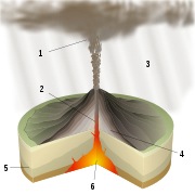
 Hawaiian eruptions are passive eruptions characterized by effusive emission of highly fluid basalt lavas with low gas contents. Like other Hawaiian eruptions, the relative volume of ejected pyroclastic material is less than that of all other eruption types. The main phenomenons during Hawaiian eruptions is steady lava fountain
ing and the production of thin lava flows that eventually build up into large, broad shield volcano
es. Eruptions are also common in central vents near the summit of shield volcanoes, and along linear volcanic vents
radiating outward from the summit area. Lava advances downslope away from their source vents in lava channels and lava tube
s.
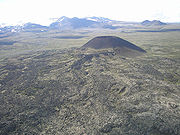 In Canada, cinder cone
s form when lava fountains release fragments of lava that harden in the air and fall around a linear volcanic vent. The rock fragments, often known as cinder
or scoria
, are glass
y and contain gas bubbles "frozen" into place as magma exploded into the air and then cooled quickly. Some of the lava is not fragmented and flows from the vent as a lava flow. Cinder cones are also called pyroclastic cones and are found in volcanic field
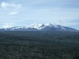
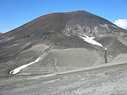
s, on the flanks of shield volcanoes, stratovolcanoes and calderas. For example, geologists have identified at least 30 young cinder cones on the Mount Edziza volcanic complex
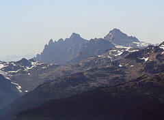
, a large shield volcano in northwestern British Columbia with an area of 1000 square kilometres (386.1 sq mi). Eve Cone
, on the northern end of the Mount Edziza volcanic complex, is one of the best preserved cinder cones in Canada, due to its undeformed and symmetrical shape.
During other Hawaiian eruptions, fluid basaltic lava may pond in vents, craters
, or broad depressions to produce lava lake
s. As lava lakes solidify, they create a grey-silver crust that is usually only a few centimeters thick. Active lava lakes comprise young crust that is repeatedly destroyed and regenerated. Convective motion of the underlying lava causes the crust to break into slabs and sink. This then exposes new lava at the surface that cools into a new crustal layer which will again fracture into slabs and be recycled into the circulating lava beneath the crust.
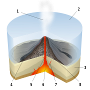
 Phreatic eruptions occur when rising magma makes contact with ground or surface water. The extreme temperature of the magma causes near-instantaneous evaporation, resulting in an explosion of steam, water, ash, rocks and volcanic bomb
s. The temperature of the rock fragments can range from cold to incandescent. If magma is included, the term phreatomagmatic may be used. Phreatomagmatic eruptions occasionally create broad, low-relief volcanic crater
s called maar
s. These explosion craters are interpreted to have formed above rubble-filled volcanic pipe
s called diatreme
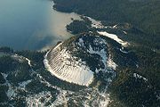
s; deep erosion of a maar presumably would expose a diatreme. Maars range in size from 61 to- across and from 9 to- deep and are commonly filled with water to form a crater lake
. Fiftytwo Ridge
at the southeastern end of Wells Gray Provincial Park
in southeastern British Columbia is an example of a volcano containing lake-filled maars. Most maars have low rims composed of a mixture of loose fragments of volcanic rocks and rocks torn from the walls of the diatreme. Phreatic explosions can be accompanied by carbon dioxide
or hydrogen sulfide
gas emissions.
 Subglacial eruptions occur when lava erupts under large portions of glacial ice. As lava erupts under a large glacier, the heat of the lava would immediately start to melt the overlying glacial ice to produce meltwater
. The resulting meltwater would quickly harden the lava to produce pillow-shaped masses called pillow lava
. In places, the pillow lava will fracture to create other types of volcanic deposits called pillow breccia, tuff breccia, and hyaloclastite
. If magma intruded and melted a vertical pipe through the overlying glacier, the partially molten mass would cool as a large block with gravity flattening its upper surface to form a flat-topped, steep-sided subglacial volcano
called a tuya
. The term tuya originates from Tuya Butte
in far northern British Columbia. While still in graduate school in 1947, Canadian geologist William Henry Mathews
coined the term "tuya" to refer to these distinctive volcanic formations and was one of the first people on Earth to describe in detail these types of subglacial volcanoes. Tuya Butte is the first such landform analyzed in the geological literature, and its name has since become standard worldwide among volcanologists in referring to and writing about tuyas. Other subglacial volcanoes, including subglacial mound
s, are formed when the erupted magma is not hot enough to melt through the overlying glacial ice. Once the glaciers melt away, the tuyas and subglacial mounds would reappear with a distinctive shape as a result of their confinement within glacial ice.
Because volcanic activity in Western and Northern Canada was contemporaneous with the ebb and flow of past glaciations, other volcanoes display ice-contact features. Mount Garibaldi
in southwestern British Columbia is the only major volcano in North America known to have formed upon a regional ice sheet during the last glacial period, which began 110,000 years ago and ended between 10,000 and 15,000 years ago. Hoodoo Mountain
in northern British Columbia was contained within basins thawed in the ice and assumed the flat-topped, steep-sided form of a tuya. Pyramid Mountain
, in the Shuswap Highland
of east-central British Columbia, was formed under more than 1000 metres (3,280.8 ft) of glacial ice to assume the form of a subglacial mound. The Fort Selkirk Volcanic Field
in central Yukon
contains volcanic features that were erupted subglacially when the large Cordilleran Ice Sheet
existed in this area between 0.8 and one million years ago.
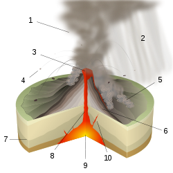
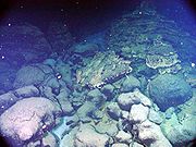
 Submarine eruptions are eruptions that occur underwater. The appearance of these eruptions is different than those that occur on land. When lava erupts it will be quickly cooled by the unlimited supply of water surrounding a submarine volcano
, creating pillow lava. Explosive fragmentation of lavas forms hyaloclastites. Deep-sea submarine eruptions usually occur where the ocean floor is being pulled apart by plate tectonic
movements called mid-ocean ridge
s, where about 75% of the Earth's magmatic eruptions occur. Shallow submarine eruptions can cause explosions of steam and volcanic ash called Surtseyan eruption
s, named for the island of Surtsey
off the southern coast of Iceland. Explosive submarine eruptions usually eject large quantities of very light volcanic rock called pumice
. This very light volcanic rock can initially float on water, forming long-lived rafts of floating pumice
carried long distances from the volcano by ocean currents. Lava flows entering water can cause explosions that form piles of ash and rubble similar to cinder cones, although they were formed from rootless vents not located above a magma conduit.
The deformed volcanic sequences that form greenstone belt
s in the Canadian Shield
contain hyaloclastite and pillow lavas, indicating these areas were once below sea level
and the lava was rapidly cooled underwater. Pillow lavas more than two billion years old indicate large submarine volcanoes existed during the early stages of the Earth's formation.
 Peléan eruptions are violent eruptions characterized by fast-moving streams of hot volcanic gas
and rock called pyroclastic flow
s or nuées ardentes. Named for the stratovolcano Mount Pelée
on the island of Martinique
in the Caribbean Sea
, Peléan eruptions occur when thick magma, typically of rhyolite
, dacite
and andesite
type, is involved, and share some similarities with another type of explosive eruption known as Vulcanian eruption
s. The thick magma associated with Peléan eruptions can form lava dome
s and lava spine
s in the volcano's vent or on the volcano's summit. Lava domes are steep-sided lava masses frequently circular in plan view and spiny, rounded, or flat on top. If a lava dome is created, it may later collapse, forming an ash column and sending flows of ash and hot volcanic blocks
down the volcano's flanks. Lava spines are upright cylindrical masses of lava caused by the upward squeezing of pasty lava inside a volcanic vent.
. Named for Italian
natural philosopher Pliny the Younger
, these spectacularly explosive eruptions are associated with magmas of high viscosity and gas content such as dacite and rhyolite and typically occur at caldera
s and stratovolcano
es. The duration of these eruptions is highly variable, ranging from hours to days, and they commonly occur at volcanic arc
s where the Earth's tectonic plates are moving towards one another, with one sliding underneath the other called a subduction
zone. Although Plinian eruptions typically involve magma with high levels of silica, such as dacite and rhyolite, they can occasionally occur at volcanoes characterized by passive basaltic eruptions, including shield volcanoes, when the magma chambers become differentiated and zoned to create a siliceous top. In some cases, a basaltic shield volcano may have periods of explosive activity to form a stratovolcano mounted on top of the shield volcano. An example of this activity includes the massive Level Mountain Range
shield volcano in northwestern British Columbia, which is capped by a 860 km³ (206 cu mi) dissected stratovolcano.
 Following massive Plinian eruptions, temperatures may decrease to cause volcanic winter
s. Volcanic winters are caused by volcanic ash and droplets of sulfuric acid
obscuring the sun's light, usually after a volcanic eruption. A massive (VEI-7
) Plinian eruption in 1815 from Mount Tambora
on the island of Sumbawa
, Indonesia
expelled more than 150 km² (57.9 sq mi) of volcanic ash
around the Earth, causing particularly long, dark and harsh volcanic winters in Eastern Canada from 1816 to 1818. The result of this was the large amount of volcanic ash blocking out the sun
's light, causing the Earth's temperature and visibility to decrease. The first volcanic winter in 1816, known as the Year Without a Summer
, affected the Canadian province of Newfoundland and Labrador
. In February 1816, a fire swept through St. John's
, leaving 1,000 people homeless and in May during the following year, frost killed most of the crops that had been planted. In June, two large winter storm
s occurred throughout Eastern Canada, resulting in several casualties. The cause was limited amount of food supplies, and further deaths from those who, in a hunger-weakened state, then succumbed to disease. Nearly a foot of snow was observed in Quebec City
. Rapid, dramatic temperature swings were common, with temperatures sometimes reverting from normal or above-normal summer temperatures as high as 35 °C to near-freezing within hours. In November 1817, two more fires swept through St. John's, leaving another 2,000 people poor. Many who had somewhere to live had low amounts of food or fuel for heating. The volcanic winters were also felt in the Maritime provinces
, which includes Nova Scotia
, New Brunswick
and Prince Edward Island
.
 The 2,677 million year old Abitibi greenstone belt
in Ontario and Quebec is one of the largest Archean greenstone belts on Earth and one of the youngest parts of the Superior craton
which sequentially forms part of the Canadian Shield.
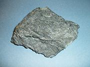
Komatiite
lavas in the Abitibi greenstone belt (pictured) occur in four lithotectonic assemblages known as Pacaud, Stoughton-Roquemaure, Kidd-Munro and Tisdale. The Swayze greenstone belt further south is interpreted to be a southwestern extension of the Abitibi greenstone belt.
The Archean
Red Lake greenstone belt
in western Ontario consists of basaltic and komatiitic volcanics ranging in age from 2,925 to 2,940 million years old and younger rhyolite-andesite volcanics ranging in age from 2,730 to 2,750 million years old. It is situated in the western portion of the Uchi Subprovince
, a volcanic sequence comprising a number of greenstone belts.
 The 1884–1864 million year old Circum-Superior Belt
constitutes a large igneous province extending for more than 3400 kilometres (2,112.7 mi) from the Labrador Trough
in Labrador
and northeastern Quebec though the Cape Smith Belt
in northern Quebec, the Belcher Islands
in southern Nunavut
, the Fox River
and Thompson
belts in northern Manitoba
, the Winnipegosis komatiite belt
in central Manitoba, and on the southern side of the Superior craton in the Animikie Basin of northwestern Ontario. Two volcano-sedimentary sequences exist in the Labrador Trough with ages of 2,170–2,140 million years and 1,883–1,870 million years. In the Cape Smith Belt, two volcanic group
s range in age from 2,040 to 1,870 million years old called the Povungnituk volcano-sedimentary Group and the Chukotat Group. The Belcher Islands in eastern Hudson Bay contain two volcanic sequences known as the Flaherty and Eskimo volcanics. The Fox River Belt consists of volcanics, sills and sediments some 1,883 million years old while magmatism of the Thompson Belt is dated to 1,880 million years old. To the south lies the 1,864 million year old Winnipegosis komatiites. In the Animikie Basin near Lake Superior, volcanism is dated 1,880 million years old.
 During the Mesoproterozoic
era of the Precambrian
period 1,109 million years ago, northwestern Ontario began to split apart to form the Midcontinent Rift System
, also called the Keweenawan Rift. Lava flows created by the rift in the Lake Superior
area were formed from basaltic magma. The upwelling of this magma was the result of a hotspot
which produced a triple junction
in the vicinity of Lake Superior. The hotspot made a dome that covered the Lake Superior area. Voluminous basaltic lava flows erupted from the central axis of the rift, similar to the rifting that formed the Atlantic Ocean
. A failed arm
extends 150 kilometres (93.2 mi) north into mainland Ontario where it forms a geological formation known as the Nipigon Embayment. This failed arm includes Lake Nipigon
, the largest lake entirely within the boundaries of Ontario.
 Periods of volcanic activity occurred throughout central Canada during the Jurassic
and Cretaceous
periods. The source for this volcanism was a long-lived and stationary area of molten rock called the New England or Great Meteor hotspot
. The first event erupted kimberlite magma in the James Bay
lowlands region of northern Ontario 180 million years ago, creating the Attawapiskat kimberlite field
. Another kimberlite event spanned a period of 13 million years 165 to 152 million years ago, creating the Kirkland Lake kimberlite field
in northeastern Ontario. Another period of kimberlite volcanism occurred in northeastern Ontario 154 to 134 million years ago, creating the Lake Timiskaming kimberlite field
. As the North American Plate moved westward over the New England hotspot, the New England hotspot created the magma intrusion
s of the Monteregian Hills in Montreal
in southern Quebec. These intrusive stocks have been variously interpreted as the feeder intrusions of long extinct volcanoes that would have been active 125 million years ago, or as intrusions that never breached the surface in volcanic activity. The lack of a noticeable hotspot track west of the Monteregian Hills might be due either to failure of the New England mantle plume to pass through massive strong rock of the Canadian Shield, the lack of noticeable intrusions, or to strengthening of the New England mantle plume when it approached the Monteregian Hills region.
 About 250 million years ago during the early Triassic
period, Atlantic Canada lied roughly in the middle of a giant continent called Pangaea
. This supercontinent
began to fracture 220 million years ago when the Earth's lithosphere
was being pulled apart from extensional stress, creating a divergent plate boundary
known as the Fundy Basin
. The focus of the rifting began somewhere between where present-day eastern North America and northwestern Africa
were joined. During the formation of the Fundy Basin, volcanic activity never stopped as shown by the going eruption of lava along the Mid-Atlantic Ridge
; an underwater volcanic mountain range
in the Atlantic Ocean
formed as a result of continuous seafloor spreading
between eastern North America and northwestern Africa. As the Fundy Basin continued to form 201 million years ago, a series of basaltic lava flows were erupted, forming a volcanic mountain range on the mainland portion of southwestern Nova Scotia
known as North Mountain
, stretching 200 kilometres (124.3 mi) from Brier Island
in the south to Cape Split
in the north. This series of lava flows cover most of the Fundy Basin and extend under the Bay of Fundy
where parts of it are exposed on the shore at the rural community of Five Islands
, east of Parrsboro
on the north side of the bay. Large dikes 4 to- wide exist throughout southernmost New Brunswick with ages and compositions similar to the North Mountain basalt, indicating these dikes were the source for North Mountain lava flows. However, North Mountain is the remnants of a larger volcanic feature that has now been largely eroded based on the existence of basin border faults and erosion. The hard basaltic ridge of North Mountain resisted the grinding of ice sheet
s that flowed over this region during the past ice age
s, and now forms one side of the Annapolis Valley
in the western part of the Nova Scotia peninsula
. The layering of a North Mountain lava flow less than 175 metres (574.1 ft) thick at McKay Head, closely resemble that of some Hawaii
an lava lake
s, indicating Hawaiian eruption
s occurred during the formation of North Mountain.
 The Fogo Seamounts
, located 500 km (311 mi) offshore of Newfoundland to the southwest of the Grand Banks, consists of submarine volcanoes with dates extending back to the Early Cretaceous
period at least 143 million years ago. They may have one or two origins. The Fogo Seamounts could have formed along fracture zones in the Atlantic seafloor because of the large number of seamounts on the North American continental shelf
. The other explanation for their origin is they formed above a mantle plume
associated with the Canary
or Azores hotspot
s in the Atlantic Ocean, based on the existence of older seamounts to the northwest and younger seamounts to the southeast. The existence of flat-topped seamounts
throughout the Fogo Seamount chain indicate some of these seamounts would once have stood above sea level
as islands that would have been volcanically active. Their flatness is due to coastal erosion, such as waves and winds. Other submarine volcanoes offshore of Eastern Canada include the poorly studied Newfoundland Seamounts
.
in central Manitoba and east-central Saskatchewan
is a collage of deformed volcanic arc
rocks ranging in age from 1,904 to 1,864 million years old during the Paleoproterozoic
sub-division of the Precambrian period. Volcanic activity between 1,890 and 1,864 million years ago produced calc-alkaline
andesite-rhyolite magmas and rare shoshonite
and trachyandesite magmas while the 1,904 million year old arc volcanism occurred in one or more separate volcanic arcs that were possibly characterized by rapid subduction of thin oceanic crust and large back-arc basin
s. In contrast, the younger 1,890 million year old volcanics indicate evidence of crustal thickening. This was due to long-term growth of the volcanic arcs by continuous volcanic activity and tectonic thickening associated with arc collisions and successive arc deformation. This in turn followed a massive mountain building event called the Trans-Hudson orogeny
.
The Cretaceous
era 145-65 million years ago was a period for active kimberlite volcanism in the Western Canadian Sedimentary Basin
of Alberta and Saskatchewan. The Fort à la Corne kimberlite field
in central Saskatchewan formed 104 to 95 million years ago during the Early Cretaceous
. Unlike most kimberlite fields on Earth, the Fort à la Corne kimberlite field formed during more than one eruptive event. Its kimberlites are among the most complete examples on Earth, preserving kimberlite pipes and maar
volcanoes. The Northern Alberta kimberlite province
consists of three kimberlite fields known as the Birch Mountains
, Buffalo Head Hills
and the Mountain Lake cluster
. The Birch Mountains kimberlite field consists of eight kimberlite pipes known as Phoenix
, Dragon
, Xena
, Legend
and Valkyrie
, dating approximately 75 million years old. The Buffalo Head Hills kimberlite field was dominated by explosive kimberlite volcanism from 88 million years ago to 81 million years ago, forming maar
s. Kimberlites of the Buffalo Head Hills field are similar to those associated with the Fort à la Corne kimberlite field in central Saskatchewan. The kimberlite pipes of the Mountain Lake cluster were formed during a similar timespan with the Birch Mountains field 77 million years ago.
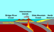 The Canadian portion of the Pacific Northwest
began forming during the early Jurassic
period when a group of active volcanic islands collided against a pre-existing continental margin
and coastline of Western Canada. These volcanic islands, known as the Intermontane Islands
by geoscientists, were formed on a pre-existing tectonic plate
called the Intermontane Plate
about 245 million years ago by subduction
of the former Insular Plate
to its west during the Triassic
period. This subduction zone records another subduction zone called the Intermontane Trench
under an ancient ocean between the Intermontane Islands and the former continental margin of Western Canada called the Slide Mountain Ocean
. This arrangement of two parallel subduction zones is unusual in that very few twin subduction zones exist on Earth; the Philippine Mobile Belt
off the eastern coast of Asia
is an example of a modern twin subduction zone. As the Intermontane Plate drew closer to the pre-existing continental margin by ongoing subduction
under the Slide Mountain Ocean, the Intermontane Islands drew closer to the former continental margin and coastline of Western Canada, supporting a volcanic arc on the former continental margin of Western Canada. As the North American Plate
drifted west and the Intermontane Plate continued to drift east to the ancient continental margin of Western Canada, the Slide Mountain Ocean began to close by ongoing subduction under the Slide Mountain Ocean. This subduction zone eventually jammed and shut down completely about 180 million years ago, ending the arc volcanism on the ancient continental margin of Western Canada and the Intermontane Islands collided, forming a long chain of deformed volcanic and sedimentary rock called the Intermontane Belt
, which consists of deeply cut valleys, high plateaus, and rolling uplands. This collision also crushed and fold
ed sedimentary
and igneous rock
s, creating a mountain range
called the Kootenay Fold Belt which existed in far eastern British Columbia.
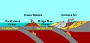 After the sedimentary and igneous rocks were folded and crushed, it resulted in the creation of a new continental shelf and coastline. The Insular Plate continued to subduct under the new continental shelf and coastline about 130 million years ago during the mid Cretaceous
period after the formation of the Intermontane Belt, supporting a new continental volcanic arc called the Omineca Arc
. Magma rising from the Omineca Arc successfully connected the Intermontane Belt to the mainland of Western Canada, forming a chain of volcanoes in British Columbia that existed discontinuously for about 60 million years. The ocean lying offshore during this period is called the Bridge River Ocean
. It was also during this period when another group of active volcanic islands existed along the newly built continental shelf and coastline. These volcanic islands, known as the Insular Islands
, were formed on the Insular Plate by subduction of the former Farallon Plate
to its west during the early Paleozoic
period. As the North American Plate
drifted west and the Insular Plate drifted east to the continental margin of Western Canada, the Bridge River Ocean began to close by ongoing subduction under the Bridge River Ocean. This subduction zone eventually jammed and shut down completely 115 million years ago, ending the Omineca Arc volcanism and the Insular Islands collided, forming the Insular Belt
. Compression resulting from this collision crushed, fractured and folded
rocks along the continental margin. The Insular Belt then welded onto the continental margin by magma that eventually cooled to create a large mass of igneous rock
, creating a new continental margin. This large mass of igneous rock is the largest granite
outcropping in North America.
 The Farallon Plate continued to subduct under the new continental margin of Western Canada after the Insular Plate and Insular Islands collided with the former continental margin, supporting a new chain of volcanoes on the mainland of Western Canada called the Coast Range Arc
about 100 million years ago during the Late Cretaceous
period. Magma ascending from the Farallon Plate under the new continental margin burned their way upward through the newly accreted Insular Belt, injecting huge quantities of granite into older igneous rocks of the Insular Belt. At the surface, new volcanoes were built along the continental margin. The basement of this arc was likely Early Cretaceous and Late Jurassic
age intrusions from the Insular Islands.
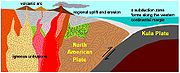 One of the major aspects that changed early during the Coast Range Arc was the status of the northern end of the Farallon Plate, a portion now known as the Kula Plate
. About 85 million years ago, the Kula Plate broke off from the Farallon Plate to form an area of seafloor spreading
called the Kula-Farallon Ridge. This change apparently had some important ramifications for regional geologic evolution. When this change was completed, Coast Range Arc volcanism returned and sections of the arc were uplifted considerably in latest Cretaceous time. This started a period of mountain building that affected much of western North America called the Laramide orogeny
. In particular a large area of dextral transpression and southwest-directed thrust faulting was active from 75 to 65 million years ago. Much of the record of this deformation has been overridden by Tertiary
age structures and the zone of Cretaceous dextral thrust faulting appears to have been widespread. It was also during this period when massive amounts of molten granite intruded highly deformed ocean rocks and assorted fragments from pre-existing island arcs, largely remnants of the Bridge River Ocean. This molten granite burned the old oceanic sediments into a glittering medium-grade metamorphic rock
called schist
. The older intrusions of the Coast Range Arc were then deformed under the heat and pressure of later intrusions, turning them into layered metamorphic rock known as gneiss
. In some places, mixtures of older intrusive rocks and the original oceanic rocks have been distorted and warped under intense heat, weight and stress to create unusual swirled patters known as migmatite
, appearing to have been nearly melted in the procedure.
Volcanism began to decline along the length of the arc about 60 million years ago during the Albian
and Aptian
faunal stage
s of the Cretaceous period. This resulted from the changing geometry of the Kula Plate, which progressively developed a more northerly movement along the mainland of Western Canada. Instead of subducting beneath Western Canada, the Kula Plate began subducting underneath southwestern Yukon and Alaska during the early Eocene
period. Volcanism along the entire length of the Coast Range Arc shut down about 50 million years ago and many of the volcanoes have disappeared from erosion. What remains of the Coast Range Arc to this day are outcrops of granite when magma intruded and cooled at depth beneath the volcanoes, forming the Coast Mountains
. During construction of intrusions 70 and 57 million years ago, the northern motion of the Kula Plate might have been between 140 mm (6 in) and 110 mm (4 in) per year. However, other geologic studies determined the Kula Plate moved at a rate as fast as 200 mm (8 in) per year.
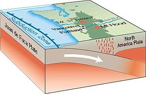 As the last of the Kula Plate decayed and the Farallon Plate advanced back into this area from the south, it once again started to subduct under the continental margin of Western Canada 37 million years ago, supporting a chain of volcanoes called the Cascade Volcanic Arc
. At least four volcanic formations along the British Columbia Coast
are associated with Cascadia subduction zone volcanism. The oldest is the eroded 18 million year old Pemberton Volcanic Belt
which extends west-northwest from south-central British Columbia to the Queen Charlotte Islands
in the northeast where it lies 150 kilometres (93.2 mi) west of mainland British Columbia. In the south it is defined by a group of epizonal intrusions and a few erosional remnants of eruptive rock. Farther north in the large Ha-Iltzuk
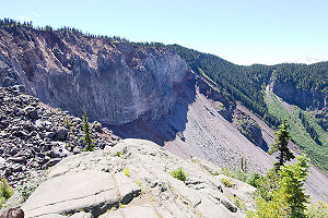
and Waddington icefields, it includes two large dissected calderas called Silverthrone Caldera
and Franklin Glacier Volcano
while the Queen Charlotte Islands to the northeast contain a volcanic formation ranging in age from Miocene
to Pliocene
called the Masset Formation
. Although widely separated from each other, all Pemberton Belt rocks are of similar age and have similar magma compositions. Therefore these magmatic rocks are believed to be products of arc volcanism related to subduction of the Farallon Plate. By late Pliocene
time the Farallon Plate had been greatly reduced in size and its northern portion ultimately broke off between five and seven million years ago to form a new plate boundary called the Nootka Fault
. This rupture created the two small Juan de Fuca
and Explorer
plates that currently lie off the west coast of Vancouver Island
.
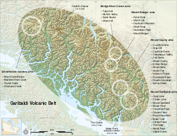
 The four million year old Garibaldi Volcanic Belt
, a north-south trending zone of volcanoes and volcanic rock in the southern Coast Mountains
of southwestern British Columbia, can be grouped into at least three enechelon segments, referred to as the northern, central, and southern segments. The northern segment overlaps the older Pemberton Volcanic Belt at a low angle near Mount Meager
where Garibaldi Belt lavas rest on uplifted and deeply eroded remnants of Pemberton Belt subvolcanic
intrusions and combines to form a single belt. A few isolated volcanoes northwest of Mount Meager, such as Silverthrone Caldera and Franklin Glacier Volcano, are also grouped as part of the Garibaldi Volcanic Belt. However, their tectonic origins are largely unexplained and are a matter of going research. When the Farallon Plate ruptured to create the Nootka Fault between five and seven million years ago, there were some apparent changes along the Cascadia subduction zone. At issue is the current plate configuration and rate of subduction
but based on rock composition is for Silverthrone Caldera and Franklin Glacier Volcano to be subduction related. The roughly circular, 20 kilometres (12.4 mi) wide, deeply dissected Silverthrone Caldera in the northern segment of the Garibaldi Volcanic Belt, was formed one million years ago during the Early Pleistocene
period. The bulk of the volcano was erupted 0.4 million years ago, but younger phases, consisting of lava flows and subsidiary volcanoes with compositions of andesite and basaltic andesite
are also present. Mount Silverthrone
, an eroded lava dome
on the northeast edge of Silverthrone Caldera, was episodically active during both Pemberton and Garibaldi stages of volcanism. The eroded Franklin Glacier Volcano
just to the southeast consists of dacite and andesite rocks that range in age from 3.9 to 2.2 million years old. Southeast of Franklin Glacier Volcano, the Bridge River Cones
comprise remnants of both andesitic and alkali basalt cones and lava flows. These range in age from about one million years old to 0.5 million years old and commonly display ice-contact features related to subglacial eruption
s. Mount Meager, the most persistent volcano in the northern portion of the Garibaldi Volcanic Belt, is a complex of at least four overlapping stratovolcanoes made of dacite and rhyodacite that become progressively younger from south to north, ranging in age from two million to 2,490 years old. The central segment of the Garibaldi Volcanic Belt is defined by a group of eight volcanoes on a ridge of highland east of the Squamish River
, and by remnants of basaltic lava flows preserved in the adjacent Squamish valley. Mount Cayley
, the largest and most persistent volcano, is a deeply eroded stratovolcano comprising a lava dome complex made of dacite and minor rhyodacite ranging in age from 3.8 to 0.31 million years old. Mount Fee
, a narrow volcanic plug
made of rhyodacite about 1 kilometres (3,280.8 ft) long and 250 metres (820.2 ft) wide, rises 150 metres (492.1 ft) above the highland ridge. Complete denudation of the central spine as well as the absence of till under lava flows from Mount Fee suggest a preglacial age. The other volcanoes of the central Garibaldi Belt, including Ember Ridge
, Pali Dome
, Cauldron Dome
, Slag Hill
, Mount Brew
and Crucible Dome, were formed during subglacial eruptions to develop tuya-like forms with over-steepened, ice-contact margins. The primary volcanoes in the southern segment are Mount Garibaldi
, Mount Price, and Black Tusk
. The oldest volcano, Black Tusk, is the remnants of an extinct andesitic stratovolcano that formed during two distant stages of volcanic activity, the first between 1.1 and 1.3 million years ago and the second between 0.17 and 0.21 million years ago. Mount Garibaldi, a fairly dissected stratovolcano 80 kilometres (49.7 mi) north of Vancouver
, was built by Peléan eruption
s between 0.26 and 0.22 million years ago during the waning stages of the last glacial, or "Wisconsinian", period. Mount Price, a less significant stratovolcano just north of Mount Garibaldi, formed during three distinct periods of volcanic activity beginning at 1.2 million years ago and culminating with the eruption of Clinker Peak
on its western flank 0.3 million years ago. In addition to the large, central andesite-dacite volcanoes, the southern portion of the Garibaldi Volcanic Belt includes remnants of basalt and basaltic andesite lava flows and pyroclastic rock
s. These include valley -filling lava flows interbedded with till containing wood about 34,000 years old.
The poorly studied Alert Bay Volcanic Belt
extends from Brooks Peninsula on the northwestern coast of Vancouver Island to Port McNeill
on the northeastern coast of Vancouver Island. It encompasses several separate remnants of late Neogene volcanic piles and related intrusions ranging in composition from basalt to rhyolite and in age from about eight million years old in the west to about 3.5 million years old elsewhere. Major element analyses of Alert Bay volcanic and hypabyssal rocks suggest two different basalt-andesite-dacite-rhyolite suites with divergent fractionation trends. The first coincides with the typical calc-alkaline, Cascade trend, whereas the other is more alkaline and more Fe-enriched following a trend which straddles the calc-alkaline-tholeiite boundary. The western end of the Alert Bay Volcanic Belt is now about 80 kilometres (49.7 mi) northeast of the Nootka Fault. However, at the time of its formation the volcanic belt may have been coincident with the subducted plate boundary. Also, the timing of volcanism corresponds to shifts of plate motion and changes in the locus of volcanism along the Pemberton and Garibaldi volcanic belts. This brief interval of plate motion adjustment at about 3.5 million years ago may have triggered the generation of basaltic magma along the descending plate edge. Because the Alert Bay Volcanic Belt has not been active for at least 3.5 million years, volcanism in the Alert Bay Volcanic Belt is probably extinct.
 The Chilcotin Group, a 50000 km² (19,305.1 sq mi) large igneous province and volcanic plateau in south-central British Columbia, consists of thin, flat-lying, poorly formed columnar basalt lava flows that have formed as a result of partial melting
in a weak zone in the upper part of the Earth's mantle
within a back-arc basin
related to subduction of the Juan de Fuca Plate. Chilcotin Group volcanism occurred in three distant magmatic episodes, the first 16-14 million years ago, the seconed 10-6 million years ago and the third 3-1 million years ago. Anahim Peak
, a volcanic plug
near the eastern flank of the Rainbow Range, and other plugs penetrating the Chilcotin Group are suggested to be vents for basalt volcanism. These volcanic plugs form a northwest trend about 150 kilometres (93.2 mi) inland from the Pemberton and Garibaldi volcanic belts and exist along the axis of the volcanic plateau. Silicic tuff
lying between Chilcotin basalt lava flows, likely originated from explosive eruption
s related to arc volcanism in the Garibaldi and Pemberton belts just to the west and was preserved between successive basaltic lava eruptions in the Chilcotin back-arc basin. It is suggested by geoscientists the Chilcotin Group forms a sequence of merged low-profile shield volcanoes erupted from central vents.
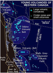
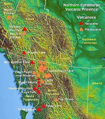 The Northern Cordilleran Volcanic Province
of northwestern British Columbia, also called the Stikine Volcanic Belt, is the most active volcanic region in Canada. It comprises a large number of small cinder cones and associated lava plains, and three large, compositionally diverse volcanoes, known as the Level Mountain Range
, the Mount Edziza volcanic complex
, and Hoodoo Mountain
. In the south the volcanic province is somewhat narrow and crosses diagonally through the northwesterly structural trend of the Coast Mountains. Farther north it is less clearly defined, forming a large arch that swings westward through central Yukon
. Volcanoes within the British Columbia portion of the Northern Cordilleran Volcanic Province are disposed along short, northerly trending en-echelon segments which, in the British Columbia portion of the volcanic province, are unmistakably involved with north-trending rift structures including synvolcanic grabens and half-grabens similar to the East African Rift
, which extends from the Afar Triple Junction
southward across eastern Africa. The Northern Cordilleran rift system formed as a result of the North American continent being stretched by extensional forces as the Pacific Plate
slides northward along the Queen Charlotte Fault
to the west, on its way to the Aleutian Trench
, which extends along the southern coastline of Alaska and the adjacent waters of northeastern Siberia
off the coast of Kamchatka Peninsula
. As the continental crust stretches, the near-surface rocks fracture along steeply dipping cracks parallel to the rift known as faults. Hot basaltic magma rises along these fractures to create passive lava eruptions. The compositions of lavas in the Northern Cordilleran Volcanic Province are mantle-derived alkali olivine basalt, lesser hawaiite
and basanite
, which form the large shield volcanoes and small cinder cones throughout the volcanic province. Many of them contain inclusions of lherzolite
. The large central volcanoes of the volcanic province consist largely of trachyte
, pantellerite
, and comendite
lavas. These lava compositions were formed by fractionation of primary alkali basalt magma in crustal reservoirs. A region of continental rifting, such as the Northern Cordilleran Volcanic Province, would support the development of high-level reservoirs of sufficient size and thermal capacity to sustain prolonged fractionation.
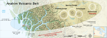 The Anahim Volcanic Belt
extends from coastal British Columbia across the Coast Mountains into the Interior Plateau. Its western end is defined by alkaline intrusive and comagmatic volcanic rocks of the Bella Bella-King Island complex, exposed in fjords and islands of the western Coast Mountains. The central portion of the Anahim Volcanic Belt contains three complex shield volcanoes, known as the Rainbow
, Ilgachuz
, and Itcha
ranges. These fairly dissected shield volcanoes lie on the northern end of the Chilcotin Group lava plateau and distal lava flows at the margins of the shield volcanoes merge imperceptibly with flat-lying lava flows comprising the Chilcotin Group lava plateau. Unlike the Chilcotin Group basalt, which is not associated with any felsic derivatives, the volcanoes of the central Anahim Volcanic Belt are markedly bimodal, comprising a mixed assemblage of basalt and peralkaline silicic rocks. While volcanoes of the Anahim Volcanic Belt appear to merge laterally with the Chilcotin Group lavas, the particular nature and connection between the Anahim Volcanic Belt and the Chilcotin Group is unknown. However, volcanoes within the Anahim Volcanic Belt usually become younger from coastal British Columbia to near the small city of Quesnel
further east, indicating these volcanoes may have formed as a result of the North American Plate passing over a possible mantle plume known as the Anahim hotspot
, whereas the Chilcotin Group is related to back-arc basin volcanism. Nazko Cone
, a cluster of basaltic cinder cones in the Nazko
area 75 kilometres (46.6 mi) west of Quesnel forms the youngest and most easterly part of the Anahim Volcanic Belt with dates of 7,200 years.
 The Explorer Ridge
, an underwater mountain range
lying 160 kilometres (99.4 mi) west of Vancouver Island
on the Coast of British Columbia, consists of a north-south trending rift zone. It contains one major segment known as the Southern Explorer Ridge, along with other smaller segments, such as the Northern Explorer Ridge. With a depth of 1800 metres (5,905.5 ft), the Southern Explorer Ridge is relatively shallow in comparison with most other rift zones of the northeast Pacific Ocean, indicating there has been considerable volcanic activity along this part of the Explorer Ridge in the past 100,000 years. Magic Mountain
, a large hydrothermal vent
area on the Southern Explorer Ridge, is a scene of this volcanic activity. Unlike most hydrothermal systems found in the Pacific Ocean, the Magic Mountain site is situated outside the primary rift zone. The source for the hydrothermal fluid that fuels Magic Mountain probably rises along fracture systems associated with a recent episode of rifting that, in turn, followed a massive outpouring of lava. In contrast, the Northern Explorer Ridge has evolved into a complex compound structure consisting of several rift basins bounded by half-graben
and arcuate shaped faults with a superimposed pattern of rhombohedral grabens and horsts.
 The Endeavour Segment, an active rift zone of the larger Juan de Fuca Ridge
on the British Columbia Coast, contains a group of active black smokers called the Endeavour Hydrothermal Vents
, located 250 kilometres (155.3 mi) southwest of Vancouver Island. This group of hydrothermal vents lies 2250 metres (7,381.9 ft) below sea level and consists of five hydrothermal fields, known as Sasquatch, Saily Dawg, High Rise, Mothra, and Main Endeavour. Like typical hydrothermal vents, the Endeavour Hydrothermal Vents form when cold seawater seeps into cracks and crevices in the Endeavour Segment where it becomes heated by magma that lies beneath the seafloor. As the water is heated, it rises and seeks a path back out into the Pacific Ocean through openings in the Endeavour Segment, forming hydrothermal vents. These hydrothermal vents release fluids with temperatures of over 300 °C
and have been a focus of research by Canadian and international scientists. The manned United States Navy
deep-ocean research submersible
DSV Alvin
and the remotely operated underwater vehicle Jason have done work at the Endeavour Hydrothermal Vents. Joint Canada-United States studies have made use of the Canadian Remotely Operated Platform for Ocean Sciences. Fisheries and Oceans Canada
has conducted extensive acoustic and mooredinstrument programs at the Endeavour Hydrothermal Vents since 1985.
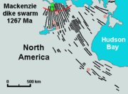 Vast volumes of basaltic lava covered Northern Canada in the form of a flood basalt
event 1,267 million years ago that engulfed the landscape near the Coppermine River
southwest of Coronation Gulf
in the Canadian Arctic. This volcanic activity built an extensive lava plateau
and large igneous province
with an area of 170000 km² (65,637 sq mi) representing a volume of lavas of at least 500000 km³ (119,956 cu mi). With an area of 170000 km² (65,637 sq mi) and a volume of at least 500000 km³ (119,956 cu mi), it is larger than the Columbia River Basalt Group
in the United States
and comparable in size to the Deccan Traps
in west-central India
, making it one of the largest flood basalt events ever to appear on the North American continent, as well as on Earth. This massive eruptive event was associated with the Mackenzie magmatic event, that included the coeval, layered, mafic-ultramafic Muskox intrusion
and the enormous Mackenzie dike swarm
that diverges from the Coppermine River flood basalts
. The maximum thickness of the flood basalts are 4.7 km (3 mi) and consist of 150 lava flows, each 4 to 100 m (13.1 to 328.1 ft) thick. These flood basalt lava flows were erupted during a single event that lasted less than five million years. Analysis of the chemical composition of the lavas gives important clues about the origin and dynamics of the flood basalt volcanism. The lowermost lavas were produced by melting in the garnet stability field below the surface at a depth of more than 90 kilometres (55.9 mi) in a mantle plume
environment beneath the North American lithosphere
. As the mantle plume intruded rocks of the Canadian Shield, it created an upwelling zone of molten rock known as the Mackenzie hotspot
. Upper lavas were partly contaminated with crustal rocks as magmas from the mantle plume passed through the lower and upper crust.
During the Early Jurassic
period 196 million years ago, the New England or Great Meteor hotspot
existed in the Rankin Inlet area of southern Nunavut along the northwestern coast of Hudson Bay
, producing kimberlite magmas. This marks the first appearance of the New England hotspot, as well as the oldest kimberlite eruption throughout the New England or Great Meteor hotspot track
, which extends southeastwards across Canada and enters the northern Atlantic Ocean
where the New England hotspot is presently located.
 The Sverdrup Basin Magmatic Province
of northern Nunavut forms a large igneous province 95 to 92 million years old in the Canadian Arctic. Part of the larger High Arctic Large Igneous Province
, it consists of two volcanic formations called the Ellesmere Island Volcanics
and Strand Fiord Formation
. In the Strand Fiord Formation, flood basalt lavas reach a thickness of at least 1 kilometres (3,280.8 ft). Flood basalts of the Sverdrup Basin Magmatic Province are similar to terrestrial flood basalts associated with breakup of continents, indicating the Sverdrup Basin Magmatic Province formed as a result of rifting of the Arctic Ocean
and when the large underwater Alpha Ridge
was still geologically active.
Widespread basalt volcanism occurred between 60.9 and 61.3 million years ago in the northern Labrador Sea
, Davis Strait
and in southern Baffin Bay
on the eastern coast of Nunavut during the Paleocene
period when North America and Greenland were being separated from tectonic movements. This resulted from seafloor spreading
where new ocean seafloor
was being created from rising magma. Scientific studies have indicated nearly 80% of the magma was erupted in one million years or less. The source for this volcanic activity was the Iceland plume
along with its surface expression, the Iceland hotspot
. This volcanic activity formed part of a large igneous province that is presently sunken beneath the northern Labrador Sea. Another period of volcanic activity began in the same region about 55 million years ago during the Eocene period when the north-south trending Mid-Atlantic Ridge
began to form under the northern Atlantic Ocean east of Greenland. The cause of this volcanism might be related to partial melting
from movement of a transform fault
system extending from Labrador Sea to the south and Baffin Bay to the north. Although the region was carried away from the Iceland plume by going plate motion over millions of years, the source of the partial melting for the final period of volcanic activity may have been remnants of still anomalously hot Iceland plume magma which were left stranded beneath the North American lithosphere in the Paleocene period. Most diatreme
s in the Northwest Territories were formed by volcanic eruptions between 45 and 75 million years ago during the Eocene
and Late Cretaceous
periods.
More recent volcanic activity has created a northwest trending line of volcanic rocks called the Wrangell Volcanic Belt
. This volcanic belt
lies largely in the U.S. state
of Alaska
, but extends across the Alaska-Yukon border into southwestern Yukon where it contains scattered remnants of subaerial lavas and pyroclastic rocks which are preserved along the entire eastern fringe of the ice covered Saint Elias Mountains
. The Wrangell Volcanic Belt formed as a result of arc volcanism related to subduction of the Pacific Plate
under the northern portion of the North American Plate. Over large areas extrusive rocks lie in flat undisturbed piles on a Tertiary surface of moderate relief. Locally, however, strata of the same age have been affected by a late pulse of tectonism, during which they were faulted, contorted into tight symmetrical folds, or overridden by pre-Tertiary basement rocks along southwesterly dipping thrust faults. Considerable recent uplift, accompanied by rapid erosion, has reduced once vast areas of upper Tertiary volcanic rocks to small isolated remnants. Although no eruptions have occurred in the Yukon portion of the Wrangell Belt for the past five million years, two large (VEI-6
) explosive eruptions from Mount Churchill
24 kilometres (14.9 mi) west of the Alaska-Yukon border, created the White River Ash
deposit. This volcanic ash deposit is estimated 1,890 and 1,250 years old, covering more than 340000 km² (131,274.7 sq mi) of northwestern Canada and adjacent eastern Alaska. Unproven legends from indigenous people
in the area indicate the final eruption from Mount Churchill 1,250 years ago disrupted food supplies and forced them to move further south.
The Yukon portion of the northwest trending Northern Cordilleran Volcanic Province
includes the youngest volcanoes in Northern Canada. The Fort Selkirk Volcanic Field
in central Yukon consists of valley-filling basalt lava flows and cinder cones. Ne Ch'e Ddhawa
, a cinder cone 2 kilometres (1.2 mi) to the connection of the Yukon
and Pelly
rivers formed between 0.8 and one million years ago when this area lied beneath the vast Cordilleran Ice Sheet
. The youngest volcano, Volcano Mountain
just north of the junction of the Yukon and Pelly rivers, formed in past 10,000 years (Holocene), producing lava flows that remain unvegetated and appear to be only a few hundred years old. However, dating of sediments in a lake impounded by the lava flows indicated that the youngest lava flows could not be younger than mid-Holocene and could be early Holocene or older. Therefore the most recent activity in the Fort Selkirk volcanic field is unknown. The lava flows from Volcano Mountain are unusual because they originate much deeper in the Earth's mantle
than the more common basaltic lava flows found throughout the Yukon and are very uncommon in the geological record. This lava, known as olivine
nephelinite
, is also unusual because it contains small, angular to rounded fragments of rock called nodules
.
 The Archean age greenstone belt
s throughout Canada are important for estimating Canada's mineral
potential. Greenstone belts containing mineralogy
are related to volcanic activity. Consequently geologists study greenstone belts to understand the volcanoes and the environment in which they erupted, and to provide a working model for mineral exploration. The 1,904 to 1,864 million year old Flin Flon greenstone belt
of central Manitoba
and east-central Saskatchewan
is one of the largest Paleoproterozoic
age volcanogenic massive sulfide ore deposit
s in the world, containing 27 copper
-zinc
-(gold
) deposits from which more than 183 million tonnes of sulfide ore have been mined. The 2,575 million year old Yellowknife greenstone belt in the Northwest Territories is the host for world-class gold deposits with total production of 15 million ounces of gold. In the Archean Hope Bay greenstone belt
of western Nunavut, three large gold deposits have been known as Doris, Boston and Madrid, while the 2,677 million year old Abitibi greenstone belt
of Ontario and Quebec is the second most prolific gold producing area on Earth; the most prolific gold producing area is the Witwatersrand
hill range in South Africa
.
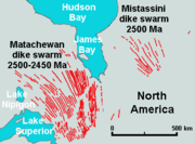
s and sills
, are known to contain base and precious metal
deposits. The 2,500 to 2,450 million year old Matachewan dike swarm
of eastern Ontario hosts the 2,491 to 2,475 million year old 20 kilometres (12.4 mi) long East Bull Lake Intrusion and associated intrusions. The 2,217 to 2,210 million year old Ungava magmatic event
was the source for the Nipissing sills
of Ontario and have been historically important for copper, silver
, and arsenic
mineralization
, and also have the potential to contain platinum group
metals. A third major event is the 1,885 to 1,865 million year old magmatism of the Circum-Superior Belt
surrounding much of the Superior craton from the Labrador Trough
in Labrador and northeastern Quebec, though the Cape Smith Belt
in northern Quebec, the Belcher Islands
in southern Nunavut, the Fox River
and Thompson
belts in northern Manitoba, the Winnipegosis komatiite belt
in central Manitoba, and on the southern side of the Superior craton
in the Animikie Basin of northwestern Ontario. Included within the Circum-Superior large igneous province are major nickel deposits of the Thompson and Raglan belts, which were likely derived from more than one magma source. The major 1,267 million year old Mackenzie dike swarm magmatism in the western part of the Canadian Shield is the host for the highly prospected Muskox intrusion
. Another significant event was the magmatism that formed the 723 million year old Franklin dike swarm
of Northern Canada and has been heavily mined for nickel, copper, and platinum group metals. The 230 million year old accreted oceanic plateau
, Wrangellia in British Columbia and Yukon, has also been searched for nickel, copper, and platinum group metals.
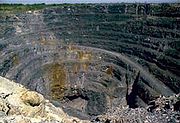
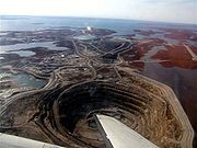 The kimberlite diatreme
s, or pipes, across Canada have also been important economically, because kimberlite magmas are the world's main source of gem-quality diamond
s. Kimberlite pipes form when kimberlite magmas rise considerably from depths as great as 400 kilometres (248.5 mi). As the kimberlite magmas approach a depth of at least 2 kilometres (1.2 mi), the magma explodes violently through the Earth's crust, carrying fragments of rock that it has collected along the way and, in the right conditions, possibly diamonds, to the surface. The Eocene
(ca. 55-50 Ma) age diatremes of the Lac de Gras kimberlite field
in the central Slave craton
of the Northwest Territories support two world-class diamond mines, called Ekati
and Diavik
. Ekati, Canada's first diamond mine, has produced 40000000 carats (8,000 kg) of diamonds out of six open pits
between 1998 and 2008, while Diavik, to the southeast, has produced 35400000 carats (7,080 kg) of diamonds since its foundation in 2003. The diamondiferous Drybones Bay kimberlite pipe
is the largest diatreme discovered in the Northwest Territories, measuring 900 by 400 m (2,952.8 by 1,312.3 ft). Diamondiferous diatremes throughout the Northwest Territories and Alberta have the potential to make Canada one of the world's major producers of gem-quality diamonds.
, more than 200 potentially active volcanoes exist throughout Canada, 49 of which have erupted in the past 10,000 years (Holocene
). This is very recent in geological terms, suggesting volcanoes in Canada have ongoing activity. Ongoing scientific studies have indicated there have been earthquakes associated with at least ten Canadian volcanoes, including: Mount Garibaldi
, Hoodoo Mountain
, Castle Rock
, Mount Cayley
, The Volcano
, Crow Lagoon
, Silverthrone Caldera
, Mount Meager
, the Wells Gray-Clearwater volcanic field
, and the Mount Edziza volcanic complex
.
 Mount Meager in the Garibaldi Volcanic Belt of southwestern British Columbia was the source for a massive (VEI
-5) Plinian eruption
2,350 years ago similar in character to the 1980 eruption of Mount St. Helens
in the U.S. state of Washington. The eruption originated from a vent on the northeast flank of Plinth Peak
, the highest and one of four overlapping stratovolcanoes which together form the Mount Meager massif. This activity produced a diverse sequence of volcanic deposits, well exposed in bluffs
along the 209 kilometres (129.9 mi) long Lillooet River
, which are grouped as part of the Pebble Creek Formation
. The explosive power associated with this Plinian eruption sent an ash column
estimated to have risen at least 20 kilometres (12.4 mi) above Meager, indicating it entered the second major layer of the Earth's atmosphere
. As prevailing winds sent ash and dust as far as 530 kilometres (329.3 mi) to the east, it created the large Bridge River Ash
deposit, extending from Mount Meager to central Alberta. Pyroclastic flow
s travelled 7 kilometres (4 mi) downstream from the vent and buried trees along Meager's forested slopes, which were burned in place. An unusual, thick apron of welded vitrophyric
breccia may represent the explosive collapse of a former lava dome
which deposited ash several meters in thickness near the vent area. This collapse blocked the Lillooet River to a height of at least 100 metres (328.1 ft), forming a lake. The lake reached a maximum elevation of 810 metres (2,657.5 ft) and thus was at least 50 metres (164 ft) deep. The pyroclastic deposts blocking the Lillooet River eventually eroded from water activity, causing a massive outburst flood that sent small house-sized boulders down the Lillooet River valley, and formed 23 metres (75.5 ft) high Keyhole Falls
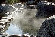
. The final phase of activity produced a 2 kilometres (1.2 mi) long glassy dacite lava flow that varies from 15 to 20 m (49.2 to 65.6 ft) thick. This is the largest known explosive eruption in Canada in the past 10,000 years. Two clusters of hot spring
s are found at Mount Meager, suggesting magmatic heat is still present and volcanic activity continues.
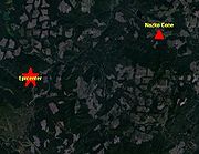
 The massive Mount Edziza volcanic complex in the Northern Cordilleran Volcanic Province of northern British Columbia has had more than 20 eruptions throughout the past 10,000 years (Holocene), including Mess Lake Cone
, Kana Cone
, Cinder Cliff
, Icefall Cone
, Ridge Cone
, Williams Cone
, Walkout Creek Cone
, Moraine Cone
, Sidas Cone
, Sleet Cone
, Storm Cone
, Triplex Cone
, Twin Cone
, Cache Hill
, Camp Hill
, Cocoa Crater, Coffee Crater
, Nahta Cone
, Tennena Cone
, The Saucer
, and the well-preserved Eve Cone
. Active or recently active hot springs are found in several areas along the western flank of Edziza's lava plateau, including Elwyn springs (36 °
C
), Taweh springs (46 °C), and inactive springs near Mess Lake
. All three hydrothermal areas are near the youngest lava fields on the lava plateau and are probably associated with the most recent volcanic activity at the Mount Edziza volcanic complex. An undated pumice
deposit exists throughout the complex estimated to be younger than 500 years old.
 Kostal Cone
in the Wells Gray-Clearwater volcanic field of east-central British Columbia is a cinder cone responsible for basaltic lava flows comprising a lava bed, damming the southern end of McDougall Lake
. There has been activity at this site as recently as 7,600 years ago at Dragon Cone
, though more likely less than 1,000 years ago. Kostal Cone is too young for the potassium-argon dating
technique (usable on specimens over 100,000 years old), and no charred organic material for radiocarbon dating
has been found. However, the uneroded structure of the cone with the existence of trees on its flanks and summit have made it an area for dendrochronology
studies, which reveals the growth of tree-ring patterns. Tree-ring dating has revealed an age of about 400 years for Kostal Cone, indicating it formed around 1500. This makes Kostal Cone the youngest volcano in the Wells Gray-Clearwater volcanic field and thus one of the youngest in Canada.
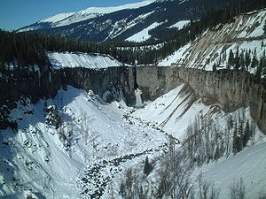
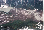
 Tseax Cone
, a young cinder cone at the southernmost end of the Northern Cordilleran Volcanic Province, was the source for a major basalt lava flow eruption around the years 1750 and 1775 that travelled into the Tseax River
, damming it and forming Lava Lake
. The lava flow subsequently travelled 11 kilometres (7 mi) north to the Nass River
, where it filled the flat valley floor for an additional 10 kilometres (6 mi), making the entire lava flow 22.5 kilometres (14 mi) long. Native legends from Nisga'a
people in the area tell of a prolonged period of disruption by the volcano, including the destruction of two Nisga'a villages known as Lax Ksiluux
and Wii Lax K'abit. Nisga'a people dug pits for shelter but at least 2,000 Nisga'a people were killed due to volcanic gas
es and poisonous smoke (most likely carbon dioxide
). This is Canada's worst known geophysical disaster. It is the only eruption in Canada for which legends of First Nations
people have been proven true. As of 1993, the Tseax Cone quietly rests in Nisga'a Memorial Lava Beds Provincial Park
.
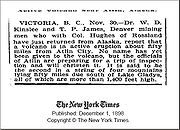 An eruption was reported by placer miners
on November 8, 1898 in the Atlin Volcanic Field
of the Northern Cordilleran Volcanic Province adjacent to Ruby Mountain
volcano 80 kilometres (49.7 mi) south of Gladys Lake when volcanic ash was said to be falling for many days. During the eruption the adjacent placer miners were able to work at nights due to incandescent glow from the eruption. A news report published on December 1, 1898 by the American newspaper publisher The New York Times
stated: Kinslee and T. P. James, Denver mining men who with Col. Hughes of Rossland have just returned from Alaska, report that a volcano is in active eruption about fifty miles from Atlin City. No name has yet been given to the volcano, but the officials of Atlin are preparing for a trip of inspection and will christen it. It is said to be the second in a string of four mountains lying fifty miles due south of Lake Gladys, all of which are more than 1,400 feet high. In 1898 the Atlin
area was in dispute with the Alaska-British Columbia boundary
, leading American news broadcasters stating the Atlin area was in Alaska rather than in northwestern British Columbia. This Alaska-British Columbia boundary dispute was eventually resolved by arbitration in 1903 and no evidence for the 1898 eruption has been found, leading researchers to speculate about the eruption and report it as uncertain.
 The Volcano
at the southern end of the Northern Cordilleran Volcanic Province just north of the Alaska-British Columbia boundary is probably the youngest in Canada. It is a poorly built cinder cone made of loose volcanic ash, lapilli
-sized tephra
and volcanic bomb
s. Lying above a remote mountain ridge in the Boundary Ranges
of the Coast Mountains, it is responsible for lava flow eruptions in 1904 and older that traveled south 5 kilometres (3 mi) through river valleys where they crossed the border into the U.S. state of Alaska and dammed the Blue River, a short tributary of the Unuk River
. In doing so it formed several small lakes. This eruption had a massive effect on fish, plant and animal inhabitants of the valley, but there is no record of its impact on people, most likely because people were not in the remote area. The entire length of the lava flows are at least 22 kilometres (13.7 mi) and still contain the original lava features from when they were erupted, including pressure ridges
and lava channels. However, sections of the lava flows have collapsed into underlying lava tube
s to form cavities. Tephra and scoria
from The Volcano covers adjacent mountain ridges and even through it is very young, it has been reduced by erosion from alpine glacial ice found in the heavily glaciated Coast Mountains. The estimated volume of lava and ash from The Volcano is 2.2 km³ (0.527808068929431 cu mi).
 A series of earthquakes of less than magnitude 3.0 were recorded by seismographs in the Baezaeko River region 20 kilometres (12.4 mi) west of Nazko Cone
in the Anahim Volcanic Belt on October 9, 2007. The cause of these earthquakes was magma intruding into rock 25 kilometres (15.5 mi) below the surface. Since then more than 1,000 small earthquakes have been recorded. Because of the small size of the earthquake swarm
s, Natural Resources Canada
has added more seismographs in the region for better location and depth accuracy. However, the size and number of the 2007 earthquake swarms indicate there is currently no threat of an eruption. Before magma could erupt in the area adjacent to Nazko Cone, it is expected the size and number of the earthquakes would rise considerably, presaging an eruption.
 In Canada, even though volcanoes pose significant threats to local communities and any sizable eruption would affect Canada's economy, the work of understanding the frequency and eruption characteristics at volcanoes in Canada is a slow process. This is because most of Canada's dormant and potentially active volcanoes are located in isolated jagged regions, very few scientists study Canadian volcanoes and the provision of money in the Canadian government is limited. Because of these issues, scientists studying Canada's volcanoes have a basic understanding of Canada's volcanic heritage and how it might impact people in the future. Volcanologists are aware that certain areas in Canada have higher levels of volcanic activity than others and how eruptions in these areas might affect people and the environment they live in. When a volcano is showing evidence of volcanic activity, quick action will be required to better understand the process. The lowest possibility for an eruption in Canada per year is approximately 1/200; for a passive lava eruption the possibility is about 1/220, and for a major explosive eruption it is about 1/3333. Even though volcanoes do not seem to be part of the everyday reality of Canadians, recurrent earthquakes and the formation of large mountain range
s in the Pacific Northwest
indicate this part of Canada is still geologically active. The possibility of an eruption, even a large explosive one, cannot be ruled out. Quiet as they currently seem, volcanoes in Northern and Western Canada are part of the Pacific Ring of Fire
. Along with volcanoes associated with recent earthquake activity, a scenario of an eruption at Mount Cayley in southwestern British Columbia illustrates how Western Canada is in danger to a volcanic eruption, which has not erupted for at least 310,000 years. This impact is becoming even more likely as population in the Pacific Northwest increases and development spreads. The scenario is based on former eruptions in the north-south trending Garibaldi Volcanic Belt and includes both explosive and passive eruptions. Its effect is mostly due to the attention of defenseless public services in canyons. However, the threat from volcanoes outside of Canada seems much greater than the threat from volcanoes within Canada because of the lack of monitoring data at Canadian volcanoes and the age of most volcanoes in Canada is poorly known. But for some, their minimal degree of erosion indicates they formed much less than 10,000 years ago, including the Milbanke Sound Group
on Price Island
, Dufferin Island
, Swindle Island
, Lake Island
, and Lady Douglas Island
in the Milbanke Sound
area of coastal British Columbia. However, it is known volcanoes in the U.S. states of Alaska, Washington, Oregon
and California
have been more active in historic times than those within Canada. Therefore volcanoes in the United States are monitored with caution and attention by the United States Geological Survey
.
 Growing awareness of volcanism, especially the threat from volcanoes in the United States, has led to a number of changes in the way Canadians are dealing with volcanic hazards. For example, The Barrier
, an unstable lava dam
retaining the Garibaldi Lake
system of southwestern British Columbia, has in the past unleashed several debris flow
s, most recently in 1855–1856. This led to the evacuation of the small resort village of Garibaldi
nearby and the relocation of residents to new recreational subdivisions away from the hazard zone. Should The Barrier completely collapse, Garibaldi Lake would be entirely released and downstream damage in the Cheakamus
and Squamish
rivers would be considerable, including major damage to the town of Squamish
and possibly an impact-wave on the waters of Howe Sound
that would reach Vancouver Island
. The Interagency Volcanic Event Notification Plan
, Canada's volcanic emergency notification program, was established to outline the notification procedure of some of the main agencies that would be involved in response to a volcanic eruption in Canada, an eruption close to Canada's borders, or an eruption significant enough to have an effect on Canada and its people. It focuses primarily on aviation safety because jet aircraft can quickly enter areas of volcanic ash. The program notifies all impacted agencies that have to deal with volcanic events. Aircraft are rerouted away from hazardous ash and people on the ground are notified of potential ash fall.
s are. An existing network of seismographs
has been established to monitor tectonic earthquakes and is too far away to provide a good indication of what is happening beneath them. It may sense an increase in activity if a volcano becomes very restless, but this may only provide a warning for a large eruption. It might detect activity only once a volcano has started erupting.
Lava
Lava refers both to molten rock expelled by a volcano during an eruption and the resulting rock after solidification and cooling. This molten rock is formed in the interior of some planets, including Earth, and some of their satellites. When first erupted from a volcanic vent, lava is a liquid at...
flows, lava plateaus
Volcanic plateau
A volcanic plateau is a plateau produced by volcanic activity. There are two main types: lava plateaus and pyroclastic plateaus.-Lava plateau:...
, lava dome
Lava dome
|250px|thumb|right|Image of the [[rhyolitic]] lava dome of [[Chaitén Volcano]] during its 2008–2009 eruption.In volcanology, a lava dome is a roughly circular mound-shaped protrusion resulting from the slow extrusion of viscous lava from a volcano...
s, cinder cone
Cinder cone
According to the , Cinder Cone is the proper name of 1 cinder cone in Canada and 7 cinder cones in the United States:In Canada: Cinder Cone In the United States:...
s, stratovolcano
Stratovolcano
A stratovolcano, also known as a composite volcano, is a tall, conical volcano built up by many layers of hardened lava, tephra, pumice, and volcanic ash. Unlike shield volcanoes, stratovolcanoes are characterized by a steep profile and periodic, explosive eruptions...
es, shield volcano
Shield volcano
A shield volcano is a type of volcano usually built almost entirely of fluid lava flows. They are named for their large size and low profile, resembling a warrior's shield. This is caused by the highly fluid lava they erupt, which travels farther than lava erupted from more explosive volcanoes...
es, submarine volcano
Submarine volcano
Submarine volcanoes are underwater fissures in the Earth's surface from which magma can erupt. They are estimated to account for 75% of annual magma output. The vast majority are located near areas of tectonic plate movement, known as ocean ridges...
es, caldera
Caldera
A caldera is a cauldron-like volcanic feature usually formed by the collapse of land following a volcanic eruption, such as the one at Yellowstone National Park in the US. They are sometimes confused with volcanic craters...
s, diatreme
Diatreme
A diatreme is a breccia-filled volcanic pipe that was formed by a gaseous explosion. Diatremes often breach the surface and produce a tuff cone, a filled relatively shallow crater known as a maar, or other volcanic pipes.- Word origin :...
s, and maar
Maar
A maar is a broad, low-relief volcanic crater that is caused by a phreatomagmatic eruption, an explosion caused by groundwater coming into contact with hot lava or magma. A maar characteristically fills with water to form a relatively shallow crater lake. The name comes from the local Moselle...
s, along with examples of more less common volcanic forms such as tuya
Tuya
A tuya is a type of distinctive, flat-topped, steep-sided volcano formed when lava erupts through a thick glacier or ice sheet. They are somewhat rare worldwide, being confined to regions which were covered by glaciers and also had active volcanism during the same time period.-Formation:Tuyas are...
s and subglacial mound
Subglacial mound
A subglacial mound is a type of subglacial volcano. This type of volcano forms when lava erupts beneath a thick glacier or ice sheet. The magma forming these volcanoes was not hot enough to melt a vertical pipe right through the overlying glacial ice, instead forming hyaloclastite and pillow lava...
s. It has a very complex volcanological history spanning from the Precambrian
Precambrian
The Precambrian is the name which describes the large span of time in Earth's history before the current Phanerozoic Eon, and is a Supereon divided into several eons of the geologic time scale...
period at least 3.11 billion years ago when this part of the North American continent began to form.
Although the country's volcanic activity dates back to the Precambrian period, volcanism continues to occur in Western
Western Canada
Western Canada, also referred to as the Western provinces and commonly as the West, is a region of Canada that includes the four provinces west of the province of Ontario.- Provinces :...
and Northern Canada
Northern Canada
Northern Canada, colloquially the North, is the vast northernmost region of Canada variously defined by geography and politics. Politically, the term refers to the three territories of Canada: Yukon, Northwest Territories, and Nunavut...
where it forms part of an encircling chain of volcanoes and frequent earthquake
Earthquake
An earthquake is the result of a sudden release of energy in the Earth's crust that creates seismic waves. The seismicity, seismism or seismic activity of an area refers to the frequency, type and size of earthquakes experienced over a period of time...
s around the Pacific Ocean
Pacific Ocean
The Pacific Ocean is the largest of the Earth's oceanic divisions. It extends from the Arctic in the north to the Southern Ocean in the south, bounded by Asia and Australia in the west, and the Americas in the east.At 165.2 million square kilometres in area, this largest division of the World...
called the Pacific Ring of Fire
Pacific Ring of Fire
The Pacific Ring of Fire is an area where large numbers of earthquakes and volcanic eruptions occur in the basin of the Pacific Ocean. In a horseshoe shape, it is associated with a nearly continuous series of oceanic trenches, volcanic arcs, and volcanic belts and/or plate movements...
. But because volcanoes in Western and Northern Canada are in remote rugged areas and the level of volcanic activity is less frequent than with other volcanoes around the Pacific Ocean, Canada is commonly thought to occupy a gap in the Pacific Ring of Fire between the volcanoes of western United States
United States
The United States of America is a federal constitutional republic comprising fifty states and a federal district...
to the south and the Aleutian volcanoes of Alaska
Alaska
Alaska is the largest state in the United States by area. It is situated in the northwest extremity of the North American continent, with Canada to the east, the Arctic Ocean to the north, and the Pacific Ocean to the west and south, with Russia further west across the Bering Strait...
to the north. However, the mountainous landscape of Western and Northern Canada includes more than 100 volcanoes that have been active during the past two million years and have claimed many lives. Volcanic activity has been responsible for many of Canada's geological and geographical features and mineralization
Mineralization (geology)
In geology, mineralization is the hydrothermal deposition of economically important metals in the formation of ore bodies or "lodes".The first scientific studies of this process took place in Cornwall, United Kingdom by J.W.Henwood FRS and later by R.W...
, including the nucleus of North America
North America
North America is a continent wholly within the Northern Hemisphere and almost wholly within the Western Hemisphere. It is also considered a northern subcontinent of the Americas...
called the Canadian Shield
Canadian Shield
The Canadian Shield, also called the Laurentian Plateau, or Bouclier Canadien , is a vast geological shield covered by a thin layer of soil that forms the nucleus of the North American or Laurentia craton. It is an area mostly composed of igneous rock which relates to its long volcanic history...
.
Volcanism has led to the formation of hundreds of volcanic areas and extensive lava formations across Canada, indicating volcanism played a major role in shaping its surface. The country's different volcano and lava types originate from different tectonic
Tectonics
Tectonics is a field of study within geology concerned generally with the structures within the lithosphere of the Earth and particularly with the forces and movements that have operated in a region to create these structures.Tectonics is concerned with the orogenies and tectonic development of...
settings and types of volcanic eruptions
Types of volcanic eruptions
During a volcanic eruption, lava, tephra , and various gases are expelled from a volcanic vent or fissure. Several types of volcanic eruptions have been distinguished by volcanologists. These are often named after famous volcanoes where that type of behavior has been observed...
, ranging from passive lava eruptions
Effusive eruption
An effusive eruption is a volcanic eruption characterized by the outpouring of lava onto the ground...
to violent explosive eruption
Explosive eruption
An explosive eruption is a volcanic term to describe a violent, explosive type of eruption. Mount St. Helens in 1980 was an example. Such an eruption is driven by gas accumulating under great pressure. Driven by hot rising magma, it interacts with ground water until the pressure increases to the...
s. Canada has a rich record of very large volumes of magmatic rock called large igneous province
Large igneous province
A Large Igneous Province is an extremely large accumulation of igneous rocks—intrusive, extrusive, or both—in the earth's crust...
s. They are represented by deep-level plumbing systems consisting of giant dike swarm
Dike swarm
A dike swarm or dyke swarm is a large geological structure consisting of a major group of parallel, linear, or radially oriented dikes intruded within continental crust. They consist of several to hundreds of dikes emplaced more or less contemporaneously during a single intrusive event and are...
s, sill
Sill (geology)
In geology, a sill is a tabular sheet intrusion that has intruded between older layers of sedimentary rock, beds of volcanic lava or tuff, or even along the direction of foliation in metamorphic rock. The term sill is synonymous with concordant intrusive sheet...
provinces and layered intrusion
Intrusion
An intrusion is liquid rock that forms under Earth's surface. Magma from under the surface is slowly pushed up from deep within the earth into any cracks or spaces it can find, sometimes pushing existing country rock out of the way, a process that can take millions of years. As the rock slowly...
s. The most capable large igneous provinces in Canada are Archean
Archean
The Archean , also spelled Archeozoic or Archæozoic) is a geologic eon before the Paleoproterozoic Era of the Proterozoic Eon, before 2.5 Ga ago. Instead of being based on stratigraphy, this date is defined chronometrically...
(3,800–2,500 million years ago) age greenstone belt
Greenstone belt
Greenstone belts are zones of variably metamorphosed mafic to ultramafic volcanic sequences with associated sedimentary rocks that occur within Archaean and Proterozoic cratons between granite and gneiss bodies....
s containing a rare volcanic rock called komatiite
Komatiite
Komatiite is a type of ultramafic mantle-derived volcanic rock. Komatiites have low silicon, potassium and aluminium, and high to extremely high magnesium content...
.
Hawaiian eruptions
Lava fountain
A lava fountain is a volcanic phenomenon in which lava is forcefully but non-explosively ejected from a crater, vent, or fissure. Lava fountains may reach heights of up to . They may occur as a series of short pulses, or a continuous jet of lava. They are commonly seen in Hawaiian eruptions.-See...
ing and the production of thin lava flows that eventually build up into large, broad shield volcano
Shield volcano
A shield volcano is a type of volcano usually built almost entirely of fluid lava flows. They are named for their large size and low profile, resembling a warrior's shield. This is caused by the highly fluid lava they erupt, which travels farther than lava erupted from more explosive volcanoes...
es. Eruptions are also common in central vents near the summit of shield volcanoes, and along linear volcanic vents
Fissure vent
A fissure vent, also known as a volcanic fissure or simply fissure, is a linear volcanic vent through which lava erupts, usually without any explosive activity. The vent is usually a few meters wide and may be many kilometers long. Fissure vents can cause large flood basalts and lava channels...
radiating outward from the summit area. Lava advances downslope away from their source vents in lava channels and lava tube
Lava tube
Lava tubes are natural conduits through which lava travels beneath the surface of a lava flow, expelled by a volcano during an eruption. They can be actively draining lava from a source, or can be extinct, meaning the lava flow has ceased and the rock has cooled and left a long, cave-like...
s.
Cinder cone
According to the , Cinder Cone is the proper name of 1 cinder cone in Canada and 7 cinder cones in the United States:In Canada: Cinder Cone In the United States:...
s form when lava fountains release fragments of lava that harden in the air and fall around a linear volcanic vent. The rock fragments, often known as cinder
Cinder
A cinder is a pyroclastic material. Cinders are extrusive igneous rocks. Cinders are similar to pumice, which has so many cavities and is such low-density that it can float on water...
or scoria
Scoria
Scoria is a volcanic rock containing many holes or vesicles. It is most generally dark in color , and basaltic or andesitic in composition. Scoria is relatively low in mass as a result of its numerous macroscopic ellipsoidal vesicles, but in contrast to pumice, all scoria has a specific gravity...
, are glass
Glass
Glass is an amorphous solid material. Glasses are typically brittle and optically transparent.The most familiar type of glass, used for centuries in windows and drinking vessels, is soda-lime glass, composed of about 75% silica plus Na2O, CaO, and several minor additives...
y and contain gas bubbles "frozen" into place as magma exploded into the air and then cooled quickly. Some of the lava is not fragmented and flows from the vent as a lava flow. Cinder cones are also called pyroclastic cones and are found in volcanic field
Volcanic field
A volcanic field is an area of the Earth's crust that is prone to localized volcanic activity. They usually contain 10 to 100 volcanoes, such as cinder cones and are usually in clusters. Lava flows may also occur...
s, on the flanks of shield volcanoes, stratovolcanoes and calderas. For example, geologists have identified at least 30 young cinder cones on the Mount Edziza volcanic complex
Mount Edziza volcanic complex
The Mount Edziza volcanic complex is a large and potentially active north-south trending complex volcano in Stikine Country, northwestern British Columbia, Canada, located southeast of the small community of Telegraph Creek...
, a large shield volcano in northwestern British Columbia with an area of 1000 square kilometres (386.1 sq mi). Eve Cone
Eve Cone
Eve Cone is a well-preserved black cinder cone on the Big Raven Plateau, British Columbia, Canada. It is one of the 30 cinder cones on the flanks of the massive shield volcano of Mount Edziza that formed in the year 700, making it one of the most recent eruptions on the Big Raven Plateau and in...
, on the northern end of the Mount Edziza volcanic complex, is one of the best preserved cinder cones in Canada, due to its undeformed and symmetrical shape.
During other Hawaiian eruptions, fluid basaltic lava may pond in vents, craters
Volcanic crater
A volcanic crater is a circular depression in the ground caused by volcanic activity. It is typically a basin, circular in form within which occurs a vent from which magma erupts as gases, lava, and ejecta. A crater can be of large dimensions, and sometimes of great depth...
, or broad depressions to produce lava lake
Lava lake
Lava lakes are large volumes of molten lava, usually basaltic, contained in a volcanic vent, crater, or broad depression. The term is used to describe both lava lakes that are wholly or partly molten and those that are solidified...
s. As lava lakes solidify, they create a grey-silver crust that is usually only a few centimeters thick. Active lava lakes comprise young crust that is repeatedly destroyed and regenerated. Convective motion of the underlying lava causes the crust to break into slabs and sink. This then exposes new lava at the surface that cools into a new crustal layer which will again fracture into slabs and be recycled into the circulating lava beneath the crust.
Phreatic and phreatomagmatic eruptions
Volcanic bomb
A volcanic bomb is a mass of molten rock larger than 65 mm in diameter, formed when a volcano ejects viscous fragments of lava during an eruption. They cool into solid fragments before they reach the ground. Because volcanic bombs cool after they leave the volcano, they do not have grains...
s. The temperature of the rock fragments can range from cold to incandescent. If magma is included, the term phreatomagmatic may be used. Phreatomagmatic eruptions occasionally create broad, low-relief volcanic crater
Volcanic crater
A volcanic crater is a circular depression in the ground caused by volcanic activity. It is typically a basin, circular in form within which occurs a vent from which magma erupts as gases, lava, and ejecta. A crater can be of large dimensions, and sometimes of great depth...
s called maar
Maar
A maar is a broad, low-relief volcanic crater that is caused by a phreatomagmatic eruption, an explosion caused by groundwater coming into contact with hot lava or magma. A maar characteristically fills with water to form a relatively shallow crater lake. The name comes from the local Moselle...
s. These explosion craters are interpreted to have formed above rubble-filled volcanic pipe
Volcanic pipe
Volcanic pipes are subterranean geological structures formed by the violent, supersonic eruption of deep-origin volcanoes. They are considered to be a type of diatreme. Volcanic pipes are composed of a deep, narrow cone of solidified magma , and are usually largely composed of one of two...
s called diatreme
Diatreme
A diatreme is a breccia-filled volcanic pipe that was formed by a gaseous explosion. Diatremes often breach the surface and produce a tuff cone, a filled relatively shallow crater known as a maar, or other volcanic pipes.- Word origin :...
s; deep erosion of a maar presumably would expose a diatreme. Maars range in size from 61 to- across and from 9 to- deep and are commonly filled with water to form a crater lake
Crater lake
A crater lake is a lake that forms in a volcanic crater or caldera, such as a maar; less commonly and with lower association to the term a lake may form in an impact crater caused by a meteorite. Sometimes lakes which form inside calderas are called caldera lakes, but often this distinction is not...
. Fiftytwo Ridge
Fiftytwo Ridge
Fiftytwo Ridge is a mountain ridge in east-central British Columbia, Canada, located just southwest of Battle Mountain at the southeastern end of Wells Gray Provincial Park.-Geology:...
at the southeastern end of Wells Gray Provincial Park
Wells Gray Provincial Park
Wells Gray Provincial Park is a large wilderness park located in east-central British Columbia, Canada. The park protects most of the southern, and highest, regions of the Cariboo Mountains and covers 5,250 square kilometres...
in southeastern British Columbia is an example of a volcano containing lake-filled maars. Most maars have low rims composed of a mixture of loose fragments of volcanic rocks and rocks torn from the walls of the diatreme. Phreatic explosions can be accompanied by carbon dioxide
Carbon dioxide
Carbon dioxide is a naturally occurring chemical compound composed of two oxygen atoms covalently bonded to a single carbon atom...
or hydrogen sulfide
Hydrogen sulfide
Hydrogen sulfide is the chemical compound with the formula . It is a colorless, very poisonous, flammable gas with the characteristic foul odor of expired eggs perceptible at concentrations as low as 0.00047 parts per million...
gas emissions.
Subglacial eruptions
Meltwater
Meltwater is the water released by the melting of snow or ice, including glacial ice and ice shelfs over oceans. Meltwater is often found in the ablation zone of glaciers, where the rate of snow cover is reducing...
. The resulting meltwater would quickly harden the lava to produce pillow-shaped masses called pillow lava
Pillow lava
Pillow lavas are lavas that contain characteristic pillow-shaped structures that are attributed to the extrusion of the lava under water, or subaqueous extrusion. Pillow lavas in volcanic rock are characterized by thick sequences of discontinuous pillow-shaped masses, commonly up to one metre in...
. In places, the pillow lava will fracture to create other types of volcanic deposits called pillow breccia, tuff breccia, and hyaloclastite
Hyaloclastite
Hyaloclastite is a hydrated tuff-like breccia rich in black volcanic glass, formed during volcanic eruptions under water, under ice or where subaerial flows reach the sea or other bodies of water. It has the appearance of angular flat fragments sized between a millimeter to few centimeters...
. If magma intruded and melted a vertical pipe through the overlying glacier, the partially molten mass would cool as a large block with gravity flattening its upper surface to form a flat-topped, steep-sided subglacial volcano
Subglacial volcano
A subglacial volcano, also known as a glaciovolcano, is a volcanic form produced by subglacial eruptions or eruptions beneath the surface of a glacier or ice sheet which is then melted into a lake by the rising lava...
called a tuya
Tuya
A tuya is a type of distinctive, flat-topped, steep-sided volcano formed when lava erupts through a thick glacier or ice sheet. They are somewhat rare worldwide, being confined to regions which were covered by glaciers and also had active volcanism during the same time period.-Formation:Tuyas are...
. The term tuya originates from Tuya Butte
Tuya Butte
Tuya Butte is a tuya in the Tuya Range of north-central British Columbia, Canada. It is a bit less isolated from other ranges than neighbouring Mount Josephine...
in far northern British Columbia. While still in graduate school in 1947, Canadian geologist William Henry Mathews
Bill Mathews
William Henry Mathews was a Canadian geologist, volcanologist, engineer, and professor. He is considered a pioneer in the study of subglacial eruptions and volcano-ice interactions in North America...
coined the term "tuya" to refer to these distinctive volcanic formations and was one of the first people on Earth to describe in detail these types of subglacial volcanoes. Tuya Butte is the first such landform analyzed in the geological literature, and its name has since become standard worldwide among volcanologists in referring to and writing about tuyas. Other subglacial volcanoes, including subglacial mound
Subglacial mound
A subglacial mound is a type of subglacial volcano. This type of volcano forms when lava erupts beneath a thick glacier or ice sheet. The magma forming these volcanoes was not hot enough to melt a vertical pipe right through the overlying glacial ice, instead forming hyaloclastite and pillow lava...
s, are formed when the erupted magma is not hot enough to melt through the overlying glacial ice. Once the glaciers melt away, the tuyas and subglacial mounds would reappear with a distinctive shape as a result of their confinement within glacial ice.
Because volcanic activity in Western and Northern Canada was contemporaneous with the ebb and flow of past glaciations, other volcanoes display ice-contact features. Mount Garibaldi
Mount Garibaldi
Mount Garibaldi is a potentially active stratovolcano in the Sea to Sky Country of British Columbia, north of Vancouver, Canada. Located in the southernmost Coast Mountains, it is one of the most recognized peaks in the South Coast region, as well as British Columbia's best known volcano...
in southwestern British Columbia is the only major volcano in North America known to have formed upon a regional ice sheet during the last glacial period, which began 110,000 years ago and ended between 10,000 and 15,000 years ago. Hoodoo Mountain
Hoodoo Mountain
Hoodoo Mountain is a potentially active flat-topped stratovolcano in the Stikine Country of northwestern British Columbia, Canada, located northeast of Wrangell, Alaska on the north side of the lower Iskut River and east of its junction with the Stikine River...
in northern British Columbia was contained within basins thawed in the ice and assumed the flat-topped, steep-sided form of a tuya. Pyramid Mountain
Pyramid Mountain (volcano)
Pyramid Mountain is a subglacial mound located on the Murtle Plateau in Wells Gray Provincial Park, east-central British Columbia, Canada.-Formation:...
, in the Shuswap Highland
Shuswap Highland
The Shuswap Highland is a plateau-like hilly area of in British Columbia, Canada. It spans the upland area between the Bonaparte and Thompson Plateaus from the area of Mahood Lake, at the southeast corner of the Cariboo Plateau, southeast towards the lower Shuswap River east of Vernon in the...
of east-central British Columbia, was formed under more than 1000 metres (3,280.8 ft) of glacial ice to assume the form of a subglacial mound. The Fort Selkirk Volcanic Field
Fort Selkirk Volcanic Field
The Fort Selkirk volcanic field is a monogenetic volcanic field in the Northern Cordilleran Volcanic Province, Yukon Territory, Canada. It is the northernmost Holocene age volcanic field in Canada, located close to the connection of the Yukon and Pelly rivers. The youngest eruptions within the...
in central Yukon
Yukon
Yukon is the westernmost and smallest of Canada's three federal territories. It was named after the Yukon River. The word Yukon means "Great River" in Gwich’in....
contains volcanic features that were erupted subglacially when the large Cordilleran Ice Sheet
Cordilleran Ice Sheet
The Cordilleran ice sheet was a major ice sheet that covered, during glacial periods of the Quaternary, a large area of North America. This included the following areas:*Western Montana*The Idaho Panhandle...
existed in this area between 0.8 and one million years ago.
Submarine eruptions
Submarine volcano
Submarine volcanoes are underwater fissures in the Earth's surface from which magma can erupt. They are estimated to account for 75% of annual magma output. The vast majority are located near areas of tectonic plate movement, known as ocean ridges...
, creating pillow lava. Explosive fragmentation of lavas forms hyaloclastites. Deep-sea submarine eruptions usually occur where the ocean floor is being pulled apart by plate tectonic
Plate tectonics
Plate tectonics is a scientific theory that describes the large scale motions of Earth's lithosphere...
movements called mid-ocean ridge
Mid-ocean ridge
A mid-ocean ridge is a general term for an underwater mountain system that consists of various mountain ranges , typically having a valley known as a rift running along its spine, formed by plate tectonics. This type of oceanic ridge is characteristic of what is known as an oceanic spreading...
s, where about 75% of the Earth's magmatic eruptions occur. Shallow submarine eruptions can cause explosions of steam and volcanic ash called Surtseyan eruption
Surtseyan eruption
A Surtseyan eruption is a type of volcanic eruption that takes place in shallow seas or lakes. It is named after the island of Surtsey off the southern coast of Iceland....
s, named for the island of Surtsey
Surtsey
Surtsey is a volcanic island off the southern coast of Iceland. At it is also the southernmost point of Iceland. It was formed in a volcanic eruption which began 130 metres below sea level, and reached the surface on 15 November 1963. The eruption lasted until 5 June 1967, when the island...
off the southern coast of Iceland. Explosive submarine eruptions usually eject large quantities of very light volcanic rock called pumice
Pumice
Pumice is a textural term for a volcanic rock that is a solidified frothy lava typically created when super-heated, highly pressurized rock is violently ejected from a volcano. It can be formed when lava and water are mixed. This unusual formation is due to the simultaneous actions of rapid...
. This very light volcanic rock can initially float on water, forming long-lived rafts of floating pumice
Pumice raft
A pumice raft is a floating raft of pumice occasionally created by ocean-based volcanic activity.Volcanic activity in the South Pacific near Tonga on August 12, 2006 caused the emergence of a new island...
carried long distances from the volcano by ocean currents. Lava flows entering water can cause explosions that form piles of ash and rubble similar to cinder cones, although they were formed from rootless vents not located above a magma conduit.
The deformed volcanic sequences that form greenstone belt
Greenstone belt
Greenstone belts are zones of variably metamorphosed mafic to ultramafic volcanic sequences with associated sedimentary rocks that occur within Archaean and Proterozoic cratons between granite and gneiss bodies....
s in the Canadian Shield
Canadian Shield
The Canadian Shield, also called the Laurentian Plateau, or Bouclier Canadien , is a vast geological shield covered by a thin layer of soil that forms the nucleus of the North American or Laurentia craton. It is an area mostly composed of igneous rock which relates to its long volcanic history...
contain hyaloclastite and pillow lavas, indicating these areas were once below sea level
Sea level
Mean sea level is a measure of the average height of the ocean's surface ; used as a standard in reckoning land elevation...
and the lava was rapidly cooled underwater. Pillow lavas more than two billion years old indicate large submarine volcanoes existed during the early stages of the Earth's formation.
Peléan eruptions
Volcanic gas
|250px|thumb|right|Image of the [[rhyolitic]] [[lava dome]] of [[Chaitén Volcano]] during its 2008-2010 eruption.Volcanic gases include a variety of substances given off by active volcanoes...
and rock called pyroclastic flow
Pyroclastic flow
A pyroclastic flow is a fast-moving current of superheated gas and rock , which reaches speeds moving away from a volcano of up to 700 km/h . The flows normally hug the ground and travel downhill, or spread laterally under gravity...
s or nuées ardentes. Named for the stratovolcano Mount Pelée
Mount Pelée
Mount Pelée is an active volcano at the northern end of the island and French overseas department of Martinique in the Lesser Antilles island arc of the Caribbean. Its volcanic cone is composed of layers of volcanic ash and hardened lava....
on the island of Martinique
Martinique
Martinique is an island in the eastern Caribbean Sea, with a land area of . Like Guadeloupe, it is an overseas region of France, consisting of a single overseas department. To the northwest lies Dominica, to the south St Lucia, and to the southeast Barbados...
in the Caribbean Sea
Caribbean Sea
The Caribbean Sea is a sea of the Atlantic Ocean located in the tropics of the Western hemisphere. It is bounded by Mexico and Central America to the west and southwest, to the north by the Greater Antilles, and to the east by the Lesser Antilles....
, Peléan eruptions occur when thick magma, typically of rhyolite
Rhyolite
This page is about a volcanic rock. For the ghost town see Rhyolite, Nevada, and for the satellite system, see Rhyolite/Aquacade.Rhyolite is an igneous, volcanic rock, of felsic composition . It may have any texture from glassy to aphanitic to porphyritic...
, dacite
Dacite
Dacite is an igneous, volcanic rock. It has an aphanitic to porphyritic texture and is intermediate in composition between andesite and rhyolite. The relative proportions of feldspars and quartz in dacite, and in many other volcanic rocks, are illustrated in the QAPF diagram...
and andesite
Andesite
Andesite is an extrusive igneous, volcanic rock, of intermediate composition, with aphanitic to porphyritic texture. In a general sense, it is the intermediate type between basalt and dacite. The mineral assemblage is typically dominated by plagioclase plus pyroxene and/or hornblende. Magnetite,...
type, is involved, and share some similarities with another type of explosive eruption known as Vulcanian eruption
Vulcanian eruption
The term Vulcanian was first used by Giuseppe Mercalli, witnessing the 1888-1890 eruptions on the island of Vulcano. His description of the eruption style is now used all over the world for eruptions characterised by a dense cloud of ash-laden gas exploding from the crater and rising high above the...
s. The thick magma associated with Peléan eruptions can form lava dome
Lava dome
|250px|thumb|right|Image of the [[rhyolitic]] lava dome of [[Chaitén Volcano]] during its 2008–2009 eruption.In volcanology, a lava dome is a roughly circular mound-shaped protrusion resulting from the slow extrusion of viscous lava from a volcano...
s and lava spine
Lava spine
A lava spine is a vertically growing monolith of viscous lava that is slowly forced from a volcanic vent, such as those growing on a lava dome . It may also be considered a kind of dome called a spiny dome . In February of 1983, the dome activity of Mount St...
s in the volcano's vent or on the volcano's summit. Lava domes are steep-sided lava masses frequently circular in plan view and spiny, rounded, or flat on top. If a lava dome is created, it may later collapse, forming an ash column and sending flows of ash and hot volcanic blocks
Volcanic blocks
A volcanic block is a fragment of rock that measures more than in diameter and is erupted in a solid condition.Blocks are formed from material from previous eruptions or from country rock and are therefore mostly accessory or accidental in origin...
down the volcano's flanks. Lava spines are upright cylindrical masses of lava caused by the upward squeezing of pasty lava inside a volcanic vent.
Plinian eruptions
Plinian eruptions are large explosive eruptions that form pyroclastic flows and enormous dark columns of tephra and gas that commonly rise into the second layer of the Earth's atmosphereStratosphere
The stratosphere is the second major layer of Earth's atmosphere, just above the troposphere, and below the mesosphere. It is stratified in temperature, with warmer layers higher up and cooler layers farther down. This is in contrast to the troposphere near the Earth's surface, which is cooler...
. Named for Italian
Italy
Italy , officially the Italian Republic languages]] under the European Charter for Regional or Minority Languages. In each of these, Italy's official name is as follows:;;;;;;;;), is a unitary parliamentary republic in South-Central Europe. To the north it borders France, Switzerland, Austria and...
natural philosopher Pliny the Younger
Pliny the Younger
Gaius Plinius Caecilius Secundus, born Gaius Caecilius or Gaius Caecilius Cilo , better known as Pliny the Younger, was a lawyer, author, and magistrate of Ancient Rome. Pliny's uncle, Pliny the Elder, helped raise and educate him...
, these spectacularly explosive eruptions are associated with magmas of high viscosity and gas content such as dacite and rhyolite and typically occur at caldera
Caldera
A caldera is a cauldron-like volcanic feature usually formed by the collapse of land following a volcanic eruption, such as the one at Yellowstone National Park in the US. They are sometimes confused with volcanic craters...
s and stratovolcano
Stratovolcano
A stratovolcano, also known as a composite volcano, is a tall, conical volcano built up by many layers of hardened lava, tephra, pumice, and volcanic ash. Unlike shield volcanoes, stratovolcanoes are characterized by a steep profile and periodic, explosive eruptions...
es. The duration of these eruptions is highly variable, ranging from hours to days, and they commonly occur at volcanic arc
Volcanic arc
A volcanic arc is a chain of volcanoes positioned in an arc shape as seen from above. Offshore volcanoes form islands, resulting in a volcanic island arc. Generally they result from the subduction of an oceanic tectonic plate under another tectonic plate, and often parallel an oceanic trench...
s where the Earth's tectonic plates are moving towards one another, with one sliding underneath the other called a subduction
Subduction
In geology, subduction is the process that takes place at convergent boundaries by which one tectonic plate moves under another tectonic plate, sinking into the Earth's mantle, as the plates converge. These 3D regions of mantle downwellings are known as "Subduction Zones"...
zone. Although Plinian eruptions typically involve magma with high levels of silica, such as dacite and rhyolite, they can occasionally occur at volcanoes characterized by passive basaltic eruptions, including shield volcanoes, when the magma chambers become differentiated and zoned to create a siliceous top. In some cases, a basaltic shield volcano may have periods of explosive activity to form a stratovolcano mounted on top of the shield volcano. An example of this activity includes the massive Level Mountain Range
Level Mountain Range
The Level Mountain Range, also known as Level Mountain, is a mountain range in Cassiar Country, northwestern British Columbia, Canada, located just northeast of Callison Ranch, southwest of Dease Lake and about north of Mount Edziza. It consists of a massive shield volcano and lies on the Nahlin...
shield volcano in northwestern British Columbia, which is capped by a 860 km³ (206 cu mi) dissected stratovolcano.
Volcanic winter
A volcanic winter is the reduction in temperature caused by volcanic ash and droplets of sulfuric acid obscuring the sun and raising Earth's albedo after a large particularly explosive type of volcanic eruption...
s. Volcanic winters are caused by volcanic ash and droplets of sulfuric acid
Sulfuric acid
Sulfuric acid is a strong mineral acid with the molecular formula . Its historical name is oil of vitriol. Pure sulfuric acid is a highly corrosive, colorless, viscous liquid. The salts of sulfuric acid are called sulfates...
obscuring the sun's light, usually after a volcanic eruption. A massive (VEI-7
Volcanic Explosivity Index
The Volcanic Explosivity Index was devised by Chris Newhall of the U.S. Geological Survey and Stephen Self at the University of Hawaii in 1982 to provide a relative measure of the explosiveness of volcanic eruptions....
) Plinian eruption in 1815 from Mount Tambora
Mount Tambora
Mount Tambora is an active stratovolcano, also known as a composite volcano, on the island of Sumbawa, Indonesia. Sumbawa is flanked both to the north and south by oceanic crust, and Tambora was formed by the active subduction zone beneath it. This raised Mount Tambora as high as , making it...
on the island of Sumbawa
Sumbawa
Sumbawa is an Indonesian island, located in the middle of the Lesser Sunda Islands chain, with Lombok to the west, Flores to the east, and Sumba further to the southeast. It is in the province of West Nusa Tenggara....
, Indonesia
Indonesia
Indonesia , officially the Republic of Indonesia , is a country in Southeast Asia and Oceania. Indonesia is an archipelago comprising approximately 13,000 islands. It has 33 provinces with over 238 million people, and is the world's fourth most populous country. Indonesia is a republic, with an...
expelled more than 150 km² (57.9 sq mi) of volcanic ash
Volcanic ash
Volcanic ash consists of small tephra, which are bits of pulverized rock and glass created by volcanic eruptions, less than in diameter. There are three mechanisms of volcanic ash formation: gas release under decompression causing magmatic eruptions; thermal contraction from chilling on contact...
around the Earth, causing particularly long, dark and harsh volcanic winters in Eastern Canada from 1816 to 1818. The result of this was the large amount of volcanic ash blocking out the sun
Sun
The Sun is the star at the center of the Solar System. It is almost perfectly spherical and consists of hot plasma interwoven with magnetic fields...
's light, causing the Earth's temperature and visibility to decrease. The first volcanic winter in 1816, known as the Year Without a Summer
Year Without a Summer
The Year Without a Summer was 1816, in which severe summer climate abnormalities caused average global temperatures to decrease by about 0.4–0.7 °C , resulting in major food shortages across the Northern Hemisphere...
, affected the Canadian province of Newfoundland and Labrador
Newfoundland and Labrador
Newfoundland and Labrador is the easternmost province of Canada. Situated in the country's Atlantic region, it incorporates the island of Newfoundland and mainland Labrador with a combined area of . As of April 2011, the province's estimated population is 508,400...
. In February 1816, a fire swept through St. John's
St. John's, Newfoundland and Labrador
St. John's is the capital and largest city in Newfoundland and Labrador, and is the oldest English-founded city in North America. It is located on the eastern tip of the Avalon Peninsula on the island of Newfoundland. With a population of 192,326 as of July 1, 2010, the St...
, leaving 1,000 people homeless and in May during the following year, frost killed most of the crops that had been planted. In June, two large winter storm
Winter storm
A winter storm is an event in which the dominant varieties of precipitation are formed that only occur at low temperatures, such as snow or sleet, or a rainstorm where ground temperatures are low enough to allow ice to form...
s occurred throughout Eastern Canada, resulting in several casualties. The cause was limited amount of food supplies, and further deaths from those who, in a hunger-weakened state, then succumbed to disease. Nearly a foot of snow was observed in Quebec City
Quebec City
Quebec , also Québec, Quebec City or Québec City is the capital of the Canadian province of Quebec and is located within the Capitale-Nationale region. It is the second most populous city in Quebec after Montreal, which is about to the southwest...
. Rapid, dramatic temperature swings were common, with temperatures sometimes reverting from normal or above-normal summer temperatures as high as 35 °C to near-freezing within hours. In November 1817, two more fires swept through St. John's, leaving another 2,000 people poor. Many who had somewhere to live had low amounts of food or fuel for heating. The volcanic winters were also felt in the Maritime provinces
Maritimes
The Maritime provinces, also called the Maritimes or the Canadian Maritimes, is a region of Eastern Canada consisting of three provinces, New Brunswick, Nova Scotia, and Prince Edward Island. On the Atlantic coast, the Maritimes are a subregion of Atlantic Canada, which also includes the...
, which includes Nova Scotia
Nova Scotia
Nova Scotia is one of Canada's three Maritime provinces and is the most populous province in Atlantic Canada. The name of the province is Latin for "New Scotland," but "Nova Scotia" is the recognized, English-language name of the province. The provincial capital is Halifax. Nova Scotia is the...
, New Brunswick
New Brunswick
New Brunswick is one of Canada's three Maritime provinces and is the only province in the federation that is constitutionally bilingual . The provincial capital is Fredericton and Saint John is the most populous city. Greater Moncton is the largest Census Metropolitan Area...
and Prince Edward Island
Prince Edward Island
Prince Edward Island is a Canadian province consisting of an island of the same name, as well as other islands. The maritime province is the smallest in the nation in both land area and population...
.
Eastern Canada
Abitibi greenstone belt
The Abitibi greenstone belt is a 2,800-2,600 million year old greenstone belt that spans across the Ontario-Quebec border in Canada. It is mostly made of volcanic rocks, but also includes ultramafic rocks, mafic intrusions, granitoid rocks, and early and middle Precambrian sediments.-Geographical...
in Ontario and Quebec is one of the largest Archean greenstone belts on Earth and one of the youngest parts of the Superior craton
Superior craton
The Superior craton forms the core of the Canadian Shield at the heart of the North American continent. It extends from Quebec in the east to eastern Manitoba in the west...
which sequentially forms part of the Canadian Shield.
Komatiite
Komatiite
Komatiite is a type of ultramafic mantle-derived volcanic rock. Komatiites have low silicon, potassium and aluminium, and high to extremely high magnesium content...
lavas in the Abitibi greenstone belt (pictured) occur in four lithotectonic assemblages known as Pacaud, Stoughton-Roquemaure, Kidd-Munro and Tisdale. The Swayze greenstone belt further south is interpreted to be a southwestern extension of the Abitibi greenstone belt.
The Archean
Archean
The Archean , also spelled Archeozoic or Archæozoic) is a geologic eon before the Paleoproterozoic Era of the Proterozoic Eon, before 2.5 Ga ago. Instead of being based on stratigraphy, this date is defined chronometrically...
Red Lake greenstone belt
Red Lake greenstone belt
The Red Lake greenstone belt is an Archean greenstone belt at the town of Red Lake in Northwestern Ontario, Canada. It consists of basaltic and komatiitic volcanics ranging in age from 2,925 to 2,940 million years old and younger rhyolite-andesite volcanics ranging in age from...
in western Ontario consists of basaltic and komatiitic volcanics ranging in age from 2,925 to 2,940 million years old and younger rhyolite-andesite volcanics ranging in age from 2,730 to 2,750 million years old. It is situated in the western portion of the Uchi Subprovince
Uchi Subprovince
The Uchi Subprovince is a Neoarchean volcanic sequence in Manitoba, Canada. It is the southern margin of the North Caribou terrane and comprises a number of greenstone belts, which contains volcanic rocks that record some 280 million years of volcanism....
, a volcanic sequence comprising a number of greenstone belts.
Circum-Superior Belt
The Circum-Superior Belt is a widespread Paleoproterozoic large igneous province in the Canadian Shield of Northern, Western and Eastern Canada. It extends more than from northeastern Manitoba through northwestern Ontario, southern Nunavut to northern Quebec...
constitutes a large igneous province extending for more than 3400 kilometres (2,112.7 mi) from the Labrador Trough
Labrador Trough
The Labrador Trough or the New Quebec Orogen is a long and wide geologic belt in Canada, extending south-southeast from Ungava Bay through Quebec and Labrador....
in Labrador
Labrador
Labrador is the distinct, northerly region of the Canadian province of Newfoundland and Labrador. It comprises the mainland portion of the province, separated from the island of Newfoundland by the Strait of Belle Isle...
and northeastern Quebec though the Cape Smith Belt
Cape Smith Belt
The Cape Smith Belt is an early Proterozoic thrust belt in northern Quebec, Canada....
in northern Quebec, the Belcher Islands
Belcher Islands
The Belcher Islands are an archipelago in Qikiqtaaluk Region, Nunavut, Canada. Located in Hudson Bay, the Belcher Islands are spread out over almost . The hamlet of Sanikiluaq is on the north coast of Flaherty Island and is the southernmost in Nunavut. Along with Flaherty Island, the other large...
in southern Nunavut
Nunavut
Nunavut is the largest and newest federal territory of Canada; it was separated officially from the Northwest Territories on April 1, 1999, via the Nunavut Act and the Nunavut Land Claims Agreement Act, though the actual boundaries had been established in 1993...
, the Fox River
Fox River Belt
The Fox River Belt is a long and to wide Paleoproterozoic geologic feature located in northern Manitoba, Canada. It consists of sedimentary and mafic/ultramafic igneous rocks....
and Thompson
Thompson Belt
The Thompson Belt, also referred to as the Thompson Nickel Belt, is an Archean and early Proterozoic geologic feature in Manitoba, Canada. It contains gneiss related to deformation of the Trans-Hudson orogeny....
belts in northern Manitoba
Manitoba
Manitoba is a Canadian prairie province with an area of . The province has over 110,000 lakes and has a largely continental climate because of its flat topography. Agriculture, mostly concentrated in the fertile southern and western parts of the province, is vital to the province's economy; other...
, the Winnipegosis komatiite belt
Winnipegosis komatiite belt
The Winnipegosis komatiite belt, also called the Winnipegosis komatiites, is a volcanic belt composed of komatiite in central Manitoba, Canada. It is part of a large igneous province surrounding much of the Superior craton called the Circum-Superior Belt....
in central Manitoba, and on the southern side of the Superior craton in the Animikie Basin of northwestern Ontario. Two volcano-sedimentary sequences exist in the Labrador Trough with ages of 2,170–2,140 million years and 1,883–1,870 million years. In the Cape Smith Belt, two volcanic group
Volcanic group
A volcanic group is a collection of related volcanoes or volcanic landforms. Note that the term is also used in a different sense when it denotes a suite of associated rock strata largely of volcanic origin; see group for details.-Notable volcanic groups:-See also:*Complex...
s range in age from 2,040 to 1,870 million years old called the Povungnituk volcano-sedimentary Group and the Chukotat Group. The Belcher Islands in eastern Hudson Bay contain two volcanic sequences known as the Flaherty and Eskimo volcanics. The Fox River Belt consists of volcanics, sills and sediments some 1,883 million years old while magmatism of the Thompson Belt is dated to 1,880 million years old. To the south lies the 1,864 million year old Winnipegosis komatiites. In the Animikie Basin near Lake Superior, volcanism is dated 1,880 million years old.
Mesoproterozoic
The Mesoproterozoic Era is a geologic era that occurred between 1600 Ma and 1000 Ma . The Mesoproterozoic was the first period of Earth's history with a respectable geological record. Continents existed in the Paleoproterozoic, but we know little about them...
era of the Precambrian
Precambrian
The Precambrian is the name which describes the large span of time in Earth's history before the current Phanerozoic Eon, and is a Supereon divided into several eons of the geologic time scale...
period 1,109 million years ago, northwestern Ontario began to split apart to form the Midcontinent Rift System
Midcontinent Rift System
The Midcontinent Rift System or Keweenawan Rift is a long geological rift in the center of the North American continent and south-central part of the North American plate. It formed when the continent's core, the North American craton, began to split apart during the Mesoproterozoic era of the...
, also called the Keweenawan Rift. Lava flows created by the rift in the Lake Superior
Lake Superior
Lake Superior is the largest of the five traditionally-demarcated Great Lakes of North America. It is bounded to the north by the Canadian province of Ontario and the U.S. state of Minnesota, and to the south by the U.S. states of Wisconsin and Michigan. It is the largest freshwater lake in the...
area were formed from basaltic magma. The upwelling of this magma was the result of a hotspot
Hotspot (geology)
The places known as hotspots or hot spots in geology are volcanic regions thought to be fed by underlying mantle that is anomalously hot compared with the mantle elsewhere. They may be on, near to, or far from tectonic plate boundaries. There are two hypotheses to explain them...
which produced a triple junction
Triple junction
A triple junction is the point where the boundaries of three tectonic plates meet. At the triple junction a boundary will be one of 3 types - a ridge, trench or transform fault - and triple junctions can be described according to the types of plate margin that meet at them...
in the vicinity of Lake Superior. The hotspot made a dome that covered the Lake Superior area. Voluminous basaltic lava flows erupted from the central axis of the rift, similar to the rifting that formed the Atlantic Ocean
Atlantic Ocean
The Atlantic Ocean is the second-largest of the world's oceanic divisions. With a total area of about , it covers approximately 20% of the Earth's surface and about 26% of its water surface area...
. A failed arm
Aulacogen
In geology, an aulacogen is a failed arm of a triple junction of a plate tectonics rift system. A triple junction beneath a continental plate initiates a three way breakup of the continental plate. As the continental break-up develops one of the three spreading ridges typically fails or stops...
extends 150 kilometres (93.2 mi) north into mainland Ontario where it forms a geological formation known as the Nipigon Embayment. This failed arm includes Lake Nipigon
Lake Nipigon
Lake Nipigon is the largest lake entirely within the boundaries of the Canadian province of Ontario . It is sometimes described as the sixth Great Lake. Lying 260 metres above sea level, the lake drains into the Nipigon River and thence into Nipigon Bay of Lake Superior...
, the largest lake entirely within the boundaries of Ontario.
Jurassic
The Jurassic is a geologic period and system that extends from about Mya to Mya, that is, from the end of the Triassic to the beginning of the Cretaceous. The Jurassic constitutes the middle period of the Mesozoic era, also known as the age of reptiles. The start of the period is marked by...
and Cretaceous
Cretaceous
The Cretaceous , derived from the Latin "creta" , usually abbreviated K for its German translation Kreide , is a geologic period and system from circa to million years ago. In the geologic timescale, the Cretaceous follows the Jurassic period and is followed by the Paleogene period of the...
periods. The source for this volcanism was a long-lived and stationary area of molten rock called the New England or Great Meteor hotspot
New England hotspot
The New England hotspot, also referred to as the Great Meteor hotspot, is a long-lived volcanic hotspot in the Atlantic Ocean. The hotspot's most recent eruptive center is the Great Meteor Seamount, and it probably created a short line of mid to late-Tertiary age seamounts on the African Plate but...
. The first event erupted kimberlite magma in the James Bay
James Bay
James Bay is a large body of water on the southern end of Hudson Bay in Canada. Both bodies of water extend from the Arctic Ocean. James Bay borders the provinces of Quebec and Ontario; islands within the bay are part of Nunavut...
lowlands region of northern Ontario 180 million years ago, creating the Attawapiskat kimberlite field
Attawapiskat kimberlite field
The Attawapiskat kimberlite field is a field of diatremes located astride the Attawapiskat River in the Hudson Bay Lowlands, in Northern Ontario, Canada...
. Another kimberlite event spanned a period of 13 million years 165 to 152 million years ago, creating the Kirkland Lake kimberlite field
Kirkland Lake kimberlite field
The Kirkland Lake kimberlite field is a 165 to 152 million year old kimberlite field in the Kirkland Lake area of northeastern Ontario, Canada.-See also:*Volcanism of Canada*Volcanism of Eastern Canada*List of volcanoes in Canada...
in northeastern Ontario. Another period of kimberlite volcanism occurred in northeastern Ontario 154 to 134 million years ago, creating the Lake Timiskaming kimberlite field
Lake Timiskaming kimberlite field
The Lake Timiskaming kimberlite field is Canada's southermost kimberlite field, located in Northeastern Ontario and western Quebec, Canada. It is within the Lake Timiskaming Structural Zone which contains over 50 kimberlite pipes, several of which are diamondiferous...
. As the North American Plate moved westward over the New England hotspot, the New England hotspot created the magma intrusion
Intrusion
An intrusion is liquid rock that forms under Earth's surface. Magma from under the surface is slowly pushed up from deep within the earth into any cracks or spaces it can find, sometimes pushing existing country rock out of the way, a process that can take millions of years. As the rock slowly...
s of the Monteregian Hills in Montreal
Montreal
Montreal is a city in Canada. It is the largest city in the province of Quebec, the second-largest city in Canada and the seventh largest in North America...
in southern Quebec. These intrusive stocks have been variously interpreted as the feeder intrusions of long extinct volcanoes that would have been active 125 million years ago, or as intrusions that never breached the surface in volcanic activity. The lack of a noticeable hotspot track west of the Monteregian Hills might be due either to failure of the New England mantle plume to pass through massive strong rock of the Canadian Shield, the lack of noticeable intrusions, or to strengthening of the New England mantle plume when it approached the Monteregian Hills region.
Triassic
The Triassic is a geologic period and system that extends from about 250 to 200 Mya . As the first period of the Mesozoic Era, the Triassic follows the Permian and is followed by the Jurassic. Both the start and end of the Triassic are marked by major extinction events...
period, Atlantic Canada lied roughly in the middle of a giant continent called Pangaea
Pangaea
Pangaea, Pangæa, or Pangea is hypothesized as a supercontinent that existed during the Paleozoic and Mesozoic eras about 250 million years ago, before the component continents were separated into their current configuration....
. This supercontinent
Supercontinent
In geology, a supercontinent is a landmass comprising more than one continental core, or craton. The assembly of cratons and accreted terranes that form Eurasia qualifies as a supercontinent today.-History:...
began to fracture 220 million years ago when the Earth's lithosphere
Lithosphere
The lithosphere is the rigid outermost shell of a rocky planet. On Earth, it comprises the crust and the portion of the upper mantle that behaves elastically on time scales of thousands of years or greater.- Earth's lithosphere :...
was being pulled apart from extensional stress, creating a divergent plate boundary
Divergent boundary
In plate tectonics, a divergent boundary or divergent plate boundary is a linear feature that exists between two tectonic plates that are moving away from each other. Divergent boundaries within continents initially produce rifts which produce rift valleys...
known as the Fundy Basin
Fundy Basin
The Fundy Basin is a sediment-filled rift basin on the Atlantic coast of southeastern Canada. It contains three sub-basins; the Fundy sub-basin, the Minas Basin and the Chignecto Basin. These arms meet at the Bay of Fundy, which is contained within the rift valley. From the Bay of Fundy, the Minas...
. The focus of the rifting began somewhere between where present-day eastern North America and northwestern Africa
Africa
Africa is the world's second largest and second most populous continent, after Asia. At about 30.2 million km² including adjacent islands, it covers 6% of the Earth's total surface area and 20.4% of the total land area...
were joined. During the formation of the Fundy Basin, volcanic activity never stopped as shown by the going eruption of lava along the Mid-Atlantic Ridge
Mid-Atlantic Ridge
The Mid-Atlantic Ridge is a mid-ocean ridge, a divergent tectonic plate boundary located along the floor of the Atlantic Ocean, and part of the longest mountain range in the world. It separates the Eurasian Plate and North American Plate in the North Atlantic, and the African Plate from the South...
; an underwater volcanic mountain range
Mountain range
A mountain range is a single, large mass consisting of a succession of mountains or narrowly spaced mountain ridges, with or without peaks, closely related in position, direction, formation, and age; a component part of a mountain system or of a mountain chain...
in the Atlantic Ocean
Atlantic Ocean
The Atlantic Ocean is the second-largest of the world's oceanic divisions. With a total area of about , it covers approximately 20% of the Earth's surface and about 26% of its water surface area...
formed as a result of continuous seafloor spreading
Seafloor spreading
Seafloor spreading is a process that occurs at mid-ocean ridges, where new oceanic crust is formed through volcanic activity and then gradually moves away from the ridge. Seafloor spreading helps explain continental drift in the theory of plate tectonics....
between eastern North America and northwestern Africa. As the Fundy Basin continued to form 201 million years ago, a series of basaltic lava flows were erupted, forming a volcanic mountain range on the mainland portion of southwestern Nova Scotia
Nova Scotia peninsula
The Nova Scotia peninsula is a peninsula on the Atlantic coast of North America.-Location:The Nova Scotia peninsula is part of the province of Nova Scotia, Canada and is connected to the neighbouring province of New Brunswick through the Isthmus of Chignecto...
known as North Mountain
North Mountain (Nova Scotia)
North Mountain is a narrow southwest-northeast trending volcanic mountain range on the mainland portion of southwestern Nova Scotia, stretching from Brier Island to Cape Split...
, stretching 200 kilometres (124.3 mi) from Brier Island
Brier Island
Brier Island is an island in the Bay of Fundy in Digby County, Nova Scotia.-Geography:The island is the western-most part of Nova Scotia and the southern end of the North Mountain ridge with Long Island lying immediately northeast; both islands constitute part of the Digby Neck...
in the south to Cape Split
Cape Split
Cape Split is a headland located on the Bay of Fundy coast of the Canadian province of Nova Scotia.Cape Split is located in Kings County and is a continuation of the North Mountain range, which is made of tholeiitic basalt...
in the north. This series of lava flows cover most of the Fundy Basin and extend under the Bay of Fundy
Bay of Fundy
The Bay of Fundy is a bay on the Atlantic coast of North America, on the northeast end of the Gulf of Maine between the Canadian provinces of New Brunswick and Nova Scotia, with a small portion touching the U.S. state of Maine...
where parts of it are exposed on the shore at the rural community of Five Islands
Five Islands, Nova Scotia
Five Islands is a rural community in Colchester County Nova Scotia with a population of 300 located on the north shore of the Minas Basin, home of the highest tides in the world...
, east of Parrsboro
Parrsboro, Nova Scotia
Parrsboro is a Canadian town located in Cumberland County, Nova Scotia.The town is known for its port on the Minas Basin, the Ship's Company Theatre productions and the Fundy Geological Museum.-History:...
on the north side of the bay. Large dikes 4 to- wide exist throughout southernmost New Brunswick with ages and compositions similar to the North Mountain basalt, indicating these dikes were the source for North Mountain lava flows. However, North Mountain is the remnants of a larger volcanic feature that has now been largely eroded based on the existence of basin border faults and erosion. The hard basaltic ridge of North Mountain resisted the grinding of ice sheet
Ice sheet
An ice sheet is a mass of glacier ice that covers surrounding terrain and is greater than 50,000 km² , thus also known as continental glacier...
s that flowed over this region during the past ice age
Ice age
An ice age or, more precisely, glacial age, is a generic geological period of long-term reduction in the temperature of the Earth's surface and atmosphere, resulting in the presence or expansion of continental ice sheets, polar ice sheets and alpine glaciers...
s, and now forms one side of the Annapolis Valley
Annapolis Valley
The Annapolis Valley is a valley and region in the Canadian province of Nova Scotia. It is located in the western part of the Nova Scotia peninsula, formed by a trough between two parallel mountain ranges along the shore of the Bay of Fundy.-Geography:...
in the western part of the Nova Scotia peninsula
Nova Scotia peninsula
The Nova Scotia peninsula is a peninsula on the Atlantic coast of North America.-Location:The Nova Scotia peninsula is part of the province of Nova Scotia, Canada and is connected to the neighbouring province of New Brunswick through the Isthmus of Chignecto...
. The layering of a North Mountain lava flow less than 175 metres (574.1 ft) thick at McKay Head, closely resemble that of some Hawaii
Hawaii
Hawaii is the newest of the 50 U.S. states , and is the only U.S. state made up entirely of islands. It is the northernmost island group in Polynesia, occupying most of an archipelago in the central Pacific Ocean, southwest of the continental United States, southeast of Japan, and northeast of...
an lava lake
Lava lake
Lava lakes are large volumes of molten lava, usually basaltic, contained in a volcanic vent, crater, or broad depression. The term is used to describe both lava lakes that are wholly or partly molten and those that are solidified...
s, indicating Hawaiian eruption
Hawaiian eruption
A Hawaiian eruption is a type of volcanic eruption where lava flows from the vent in a relative gentle, low level eruption, so called because it is characteristic of Hawaiian volcanoes. Typically they are effusive eruptions, with basaltic magmas of low viscosity, low content of gases, and high...
s occurred during the formation of North Mountain.
Fogo Seamounts
The Fogo Seamounts, also called the Fogo Seamount chain, are a group of seamounts located about offshore of Newfoundland and southwest of the Grand Banks of Newfoundland. They consist of basaltic submarine volcanoes that formed during the Early Cretaceous period.The volcanic activity that formed...
, located 500 km (311 mi) offshore of Newfoundland to the southwest of the Grand Banks, consists of submarine volcanoes with dates extending back to the Early Cretaceous
Early Cretaceous
The Early Cretaceous or the Lower Cretaceous , is the earlier or lower of the two major divisions of the Cretaceous...
period at least 143 million years ago. They may have one or two origins. The Fogo Seamounts could have formed along fracture zones in the Atlantic seafloor because of the large number of seamounts on the North American continental shelf
Continental shelf
The continental shelf is the extended perimeter of each continent and associated coastal plain. Much of the shelf was exposed during glacial periods, but is now submerged under relatively shallow seas and gulfs, and was similarly submerged during other interglacial periods. The continental margin,...
. The other explanation for their origin is they formed above a mantle plume
Mantle plume
A mantle plume is a hypothetical thermal diapir of abnormally hot rock that nucleates at the core-mantle boundary and rises through the Earth's mantle. Such plumes were invoked in 1971 to explain volcanic regions that were not thought to be explicable by the then-new theory of plate tectonics. Some...
associated with the Canary
Canary hotspot
The Canary hotspot, also called the Canarian hotspot, is a volcanic hotspot believed to be located at the Canary Islands off the north-western coast of Africa, although alternative theories to explain the volcanism there exist. The Canary hotspot is believed to be underlain by a mantle plume that...
or Azores hotspot
Azores hotspot
The Azores hotspot is a volcanic hotspot located at the Azores in the northern Atlantic Ocean. It has interactions with the Mid-Atlantic Ridge which lies just west of the hotspot.-References:**...
s in the Atlantic Ocean, based on the existence of older seamounts to the northwest and younger seamounts to the southeast. The existence of flat-topped seamounts
Guyot
A guyot , also known as a tablemount, is an isolated underwater volcanic mountain , with a flat top over 200 meters below the surface of the sea. The diameters of these flat summits can exceed ....
throughout the Fogo Seamount chain indicate some of these seamounts would once have stood above sea level
Sea level
Mean sea level is a measure of the average height of the ocean's surface ; used as a standard in reckoning land elevation...
as islands that would have been volcanically active. Their flatness is due to coastal erosion, such as waves and winds. Other submarine volcanoes offshore of Eastern Canada include the poorly studied Newfoundland Seamounts
Newfoundland Seamounts
The Newfoundland Seamounts are a group of seamounts offshore of Eastern Canada in the northern Atlantic Ocean. Named for the island of Newfoundland, this group of seamounts formed during the Cretaceous period and are poorly studied.-See also:...
.
Western Canada
The Flin Flon greenstone beltFlin Flon greenstone belt
The Flin Flon greenstone belt, also referred to as the Flin Flon-Snow Lake greenstone belt, is a Precambrian greenstone belt located in the central area of Manitoba and east-central Saskatchewan, Canada . It lies in the central portion of the Trans-Hudson orogeny and was formed by arc volcanism...
in central Manitoba and east-central Saskatchewan
Saskatchewan
Saskatchewan is a prairie province in Canada, which has an area of . Saskatchewan is bordered on the west by Alberta, on the north by the Northwest Territories, on the east by Manitoba, and on the south by the U.S. states of Montana and North Dakota....
is a collage of deformed volcanic arc
Volcanic arc
A volcanic arc is a chain of volcanoes positioned in an arc shape as seen from above. Offshore volcanoes form islands, resulting in a volcanic island arc. Generally they result from the subduction of an oceanic tectonic plate under another tectonic plate, and often parallel an oceanic trench...
rocks ranging in age from 1,904 to 1,864 million years old during the Paleoproterozoic
Paleoproterozoic
The Paleoproterozoic is the first of the three sub-divisions of the Proterozoic occurring between . This is when the continents first stabilized...
sub-division of the Precambrian period. Volcanic activity between 1,890 and 1,864 million years ago produced calc-alkaline
Calc-alkaline
The calc-alkaline magma series is one of two main magma series in igneous rocks, the other magma series being the tholeiitic. A magma series is a series of compositions that describes the evolution of a mafic magma, which is high in magnesium and iron and produces basalt or gabbro, as it...
andesite-rhyolite magmas and rare shoshonite
Shoshonite
Shoshonite is a basaltic rock, properly a potassic trachyandesite, composed of olivine, augite and plagioclase phenocrysts in a groundmass with calcic plagioclase and sanidine and some dark-colored volcanic glass. Shoshonite gives its name to the shoshonite series and grades into absarokite with...
and trachyandesite magmas while the 1,904 million year old arc volcanism occurred in one or more separate volcanic arcs that were possibly characterized by rapid subduction of thin oceanic crust and large back-arc basin
Back-arc basin
Back-arc basins are geologic features, submarine basins associated with island arcs and subduction zones.They are found at some convergent plate boundaries, presently concentrated in the Western Pacific ocean. Most of them result from tensional forces caused by oceanic trench rollback and the...
s. In contrast, the younger 1,890 million year old volcanics indicate evidence of crustal thickening. This was due to long-term growth of the volcanic arcs by continuous volcanic activity and tectonic thickening associated with arc collisions and successive arc deformation. This in turn followed a massive mountain building event called the Trans-Hudson orogeny
Trans-Hudson orogeny
The Trans-Hudson orogeny, Trans-Hudsonian orogeny, Trans-Hudson orogen , or Trans-Hudson Orogen Transect , , was the major mountain building event that formed the Precambrian Canadian Shield, the North American craton , and the...
.
The Cretaceous
Cretaceous
The Cretaceous , derived from the Latin "creta" , usually abbreviated K for its German translation Kreide , is a geologic period and system from circa to million years ago. In the geologic timescale, the Cretaceous follows the Jurassic period and is followed by the Paleogene period of the...
era 145-65 million years ago was a period for active kimberlite volcanism in the Western Canadian Sedimentary Basin
Western Canadian Sedimentary Basin
The Western Canadian Sedimentary Basin is a vast sedimentary basin underlying of Western Canada including southwestern Manitoba, southern Saskatchewan, Alberta, northeastern British Columbia and the southwest corner of the Northwest Territories. It consists of a massive wedge of sedimentary rock...
of Alberta and Saskatchewan. The Fort à la Corne kimberlite field
Fort à la Corne kimberlite field
The Fort à la Corne kimberlite field is a 104-95 million year old diamond-bearing kimberlite field in east-central Saskatchewan, Canada. Its kimberlite pipes are among the most complete examples in the world, preserving maar-shaped craters.-See also:...
in central Saskatchewan formed 104 to 95 million years ago during the Early Cretaceous
Early Cretaceous
The Early Cretaceous or the Lower Cretaceous , is the earlier or lower of the two major divisions of the Cretaceous...
. Unlike most kimberlite fields on Earth, the Fort à la Corne kimberlite field formed during more than one eruptive event. Its kimberlites are among the most complete examples on Earth, preserving kimberlite pipes and maar
Maar
A maar is a broad, low-relief volcanic crater that is caused by a phreatomagmatic eruption, an explosion caused by groundwater coming into contact with hot lava or magma. A maar characteristically fills with water to form a relatively shallow crater lake. The name comes from the local Moselle...
volcanoes. The Northern Alberta kimberlite province
Northern Alberta kimberlite province
The Northern Alberta kimberlite province is a cluster of kimberlite pipes in Northern Alberta, Canada. It consists of three kimberlite fields, including the Birch Mountains, Buffalo Head Hills, and Mountain Lake cluster.-See also:...
consists of three kimberlite fields known as the Birch Mountains
Birch Mountains kimberlite field
The Birch Mountains kimberlite field is a kimberlite field in Northern Alberta, Canada. It is a product of kimberlite volcanism during the Cretaceous period which was the most prolific period for worldwide kimberlite volcanism...
, Buffalo Head Hills
Buffalo Head Hills kimberlite field
The Buffalo Head Hills kimberlite field is a kimberlite field in north-central Alberta, Canada. It is a product of kimberlite volcanism during the Cretaceous period which was the most prolific period for worldwide kimberlite volcanism...
and the Mountain Lake cluster
Mountain Lake cluster
The Mountain Lake cluster is a group of two diatremes in Northern Alberta, Canada. It formed during a period of kimberlite volcanism about 77 million years ago...
. The Birch Mountains kimberlite field consists of eight kimberlite pipes known as Phoenix
Phoenix pipe
The Phoenix pipe is a diatreme associated with the Birch Mountains kimberlite field in northern Alberta, Canada. It is thought to have formed about 75 million years ago when this part of Alberta was volcanically active during the Late Cretaceous period....
, Dragon
Dragon pipe
The Dragon pipe is a diatreme associated with the Birch Mountains kimberlite field in northern Alberta, Canada. It is thought to have formed about 75 million years ago when this part of Alberta was volcanically active during the Late Cretaceous period....
, Xena
Xena pipe
The Xena pipe is a diatreme associated with the Birch Mountains kimberlite field in northern Alberta, Canada. It is thought to have formed about 75 million years ago when this part of Alberta was volcanically active during the Late Cretaceous period.-See also:...
, Legend
Legend pipe
The Legend pipe is a diatreme associated with the Birch Mountains kimberlite field in northern Alberta, Canada. It is thought to have formed about 75 million years ago during the Late Cretaceous period.-See also:*Volcanism of Canada...
and Valkyrie
Valkyrie pipe
The Valkyrie pipe is a diatreme in northern Alberta, Canada. It is associated with a group of diatremes called the Birch Mountains kimberlite field which is thought to have formed about 75 million years ago when this part of Alberta was volcanically active during the Late Cretaceous period.-See...
, dating approximately 75 million years old. The Buffalo Head Hills kimberlite field was dominated by explosive kimberlite volcanism from 88 million years ago to 81 million years ago, forming maar
Maar
A maar is a broad, low-relief volcanic crater that is caused by a phreatomagmatic eruption, an explosion caused by groundwater coming into contact with hot lava or magma. A maar characteristically fills with water to form a relatively shallow crater lake. The name comes from the local Moselle...
s. Kimberlites of the Buffalo Head Hills field are similar to those associated with the Fort à la Corne kimberlite field in central Saskatchewan. The kimberlite pipes of the Mountain Lake cluster were formed during a similar timespan with the Birch Mountains field 77 million years ago.
Formation of the Pacific Northwest
Pacific Northwest
The Pacific Northwest is a region in northwestern North America, bounded by the Pacific Ocean to the west and, loosely, by the Rocky Mountains on the east. Definitions of the region vary and there is no commonly agreed upon boundary, even among Pacific Northwesterners. A common concept of the...
began forming during the early Jurassic
Jurassic
The Jurassic is a geologic period and system that extends from about Mya to Mya, that is, from the end of the Triassic to the beginning of the Cretaceous. The Jurassic constitutes the middle period of the Mesozoic era, also known as the age of reptiles. The start of the period is marked by...
period when a group of active volcanic islands collided against a pre-existing continental margin
Continental margin
The continental margin is the zone of the ocean floor that separates the thin oceanic crust from thick continental crust. Continental margins constitute about 28% of the oceanic area....
and coastline of Western Canada. These volcanic islands, known as the Intermontane Islands
Intermontane Islands
The Intermontane Islands were a giant chain of active volcanic islands somewhere in the Pacific Ocean during the Triassic time beginning around 245 million years ago. They were 600 to long and rode atop a microplate known as the Intermontane Plate...
by geoscientists, were formed on a pre-existing tectonic plate
Plate tectonics
Plate tectonics is a scientific theory that describes the large scale motions of Earth's lithosphere...
called the Intermontane Plate
Intermontane Plate
The Intermontane Plate was an ancient oceanic tectonic plate that lay on the west coast of North America about 195 million years ago. The Intermontane Plate had a chain of volcanic islands called the Intermontane Islands. The Intermontane Islands had been accumulating as a volcanic chain in the...
about 245 million years ago by subduction
Subduction
In geology, subduction is the process that takes place at convergent boundaries by which one tectonic plate moves under another tectonic plate, sinking into the Earth's mantle, as the plates converge. These 3D regions of mantle downwellings are known as "Subduction Zones"...
of the former Insular Plate
Insular Plate
The Insular Plate was an ancient oceanic plate that began subducting under the west-coast of North America around the early Cretaceous time. The Insular Plate had a chain of active volcanic islands that were called the Insular Islands...
to its west during the Triassic
Triassic
The Triassic is a geologic period and system that extends from about 250 to 200 Mya . As the first period of the Mesozoic Era, the Triassic follows the Permian and is followed by the Jurassic. Both the start and end of the Triassic are marked by major extinction events...
period. This subduction zone records another subduction zone called the Intermontane Trench
Intermontane Trench
The Intermontane Trench was an ancient oceanic trench during the Triassic time. The trench was probably 600 to 800 miles long, parallel to the west coast of North America. The ocean that the trench was located in was called the Slide Mountain Ocean....
under an ancient ocean between the Intermontane Islands and the former continental margin of Western Canada called the Slide Mountain Ocean
Slide Mountain Ocean
The Slide Mountain Ocean was an ancient ocean that existed between the Intermontane Islands and North America in the Triassic time beginning around 245 million years ago. Its name origin comes from the Slide Mountain Terrane, a region made of rocks from the floor of the ancient ocean...
. This arrangement of two parallel subduction zones is unusual in that very few twin subduction zones exist on Earth; the Philippine Mobile Belt
Philippine Mobile Belt
The Philippine Mobile Belt is a complex portion of the tectonic boundary between the Eurasian Plate and the Philippine Sea Plate, comprising most of the country of the Philippines. It includes two subduction zones, the Manila Trench to the west and the Philippine Trench to the east, as well as the...
off the eastern coast of Asia
Asia
Asia is the world's largest and most populous continent, located primarily in the eastern and northern hemispheres. It covers 8.7% of the Earth's total surface area and with approximately 3.879 billion people, it hosts 60% of the world's current human population...
is an example of a modern twin subduction zone. As the Intermontane Plate drew closer to the pre-existing continental margin by ongoing subduction
Subduction
In geology, subduction is the process that takes place at convergent boundaries by which one tectonic plate moves under another tectonic plate, sinking into the Earth's mantle, as the plates converge. These 3D regions of mantle downwellings are known as "Subduction Zones"...
under the Slide Mountain Ocean, the Intermontane Islands drew closer to the former continental margin and coastline of Western Canada, supporting a volcanic arc on the former continental margin of Western Canada. As the North American Plate
North American Plate
The North American Plate is a tectonic plate covering most of North America, Greenland, Cuba, Bahamas, and parts of Siberia, Japan and Iceland. It extends eastward to the Mid-Atlantic Ridge and westward to the Chersky Range in eastern Siberia. The plate includes both continental and oceanic crust...
drifted west and the Intermontane Plate continued to drift east to the ancient continental margin of Western Canada, the Slide Mountain Ocean began to close by ongoing subduction under the Slide Mountain Ocean. This subduction zone eventually jammed and shut down completely about 180 million years ago, ending the arc volcanism on the ancient continental margin of Western Canada and the Intermontane Islands collided, forming a long chain of deformed volcanic and sedimentary rock called the Intermontane Belt
Intermontane Belt
The Intermontane Belt is a physiogeological region in the Pacific Northwest of North America, stretching from northern Washington into British Columbia, Yukon, and Alaska. It comprises rolling hills, high plateaus and deeply cut valleys. The rocks in the belt have very little similarities with the...
, which consists of deeply cut valleys, high plateaus, and rolling uplands. This collision also crushed and fold
Fold (geology)
The term fold is used in geology when one or a stack of originally flat and planar surfaces, such as sedimentary strata, are bent or curved as a result of permanent deformation. Synsedimentary folds are those due to slumping of sedimentary material before it is lithified. Folds in rocks vary in...
ed sedimentary
Sedimentary rock
Sedimentary rock are types of rock that are formed by the deposition of material at the Earth's surface and within bodies of water. Sedimentation is the collective name for processes that cause mineral and/or organic particles to settle and accumulate or minerals to precipitate from a solution....
and igneous rock
Igneous rock
Igneous rock is one of the three main rock types, the others being sedimentary and metamorphic rock. Igneous rock is formed through the cooling and solidification of magma or lava...
s, creating a mountain range
Mountain range
A mountain range is a single, large mass consisting of a succession of mountains or narrowly spaced mountain ridges, with or without peaks, closely related in position, direction, formation, and age; a component part of a mountain system or of a mountain chain...
called the Kootenay Fold Belt which existed in far eastern British Columbia.
Cretaceous
The Cretaceous , derived from the Latin "creta" , usually abbreviated K for its German translation Kreide , is a geologic period and system from circa to million years ago. In the geologic timescale, the Cretaceous follows the Jurassic period and is followed by the Paleogene period of the...
period after the formation of the Intermontane Belt, supporting a new continental volcanic arc called the Omineca Arc
Omineca Arc
The Omineca Arc or Omineca Belt was a Jurassic through Cretaceous volcanic arc terrane in western North America, extending from Alaska through Yukon and British Columbia to Washington. The Omeneca is bounded by the Foreland Belt to the east and the Intermontane Belt to the west...
. Magma rising from the Omineca Arc successfully connected the Intermontane Belt to the mainland of Western Canada, forming a chain of volcanoes in British Columbia that existed discontinuously for about 60 million years. The ocean lying offshore during this period is called the Bridge River Ocean
Bridge River Ocean
The Bridge River Ocean was an ancient ocean that existed between North America and the Insular Islands during the Paleozoic time. Like the earlier Slide Mountain Ocean the Bridge River Ocean had a subduction zone on the ocean floor called the Insular Trench...
. It was also during this period when another group of active volcanic islands existed along the newly built continental shelf and coastline. These volcanic islands, known as the Insular Islands
Insular Islands
The Insular Islands were a giant chain of active volcanic islands somewhere in the Pacific Ocean during the Cretaceous time that rode on top a microplate called the Insular Plate, beginning around 130 million years ago. The Insular Islands were surrounded by two prehistoric oceans; the Panthalassa...
, were formed on the Insular Plate by subduction of the former Farallon Plate
Farallon Plate
The Farallon Plate was an ancient oceanic plate, which began subducting under the west coast of the North American Plate— then located in modern Utah— as Pangaea broke apart during the Jurassic Period...
to its west during the early Paleozoic
Paleozoic
The Paleozoic era is the earliest of three geologic eras of the Phanerozoic eon, spanning from roughly...
period. As the North American Plate
North American Plate
The North American Plate is a tectonic plate covering most of North America, Greenland, Cuba, Bahamas, and parts of Siberia, Japan and Iceland. It extends eastward to the Mid-Atlantic Ridge and westward to the Chersky Range in eastern Siberia. The plate includes both continental and oceanic crust...
drifted west and the Insular Plate drifted east to the continental margin of Western Canada, the Bridge River Ocean began to close by ongoing subduction under the Bridge River Ocean. This subduction zone eventually jammed and shut down completely 115 million years ago, ending the Omineca Arc volcanism and the Insular Islands collided, forming the Insular Belt
Insular Belt
The Insular Belt is a physiogeological region on the north western North American coast. It consist of three major island groups and many smaller islands and stretches from southern British Columbia into Alaska and the Yukon...
. Compression resulting from this collision crushed, fractured and folded
Fold (geology)
The term fold is used in geology when one or a stack of originally flat and planar surfaces, such as sedimentary strata, are bent or curved as a result of permanent deformation. Synsedimentary folds are those due to slumping of sedimentary material before it is lithified. Folds in rocks vary in...
rocks along the continental margin. The Insular Belt then welded onto the continental margin by magma that eventually cooled to create a large mass of igneous rock
Igneous rock
Igneous rock is one of the three main rock types, the others being sedimentary and metamorphic rock. Igneous rock is formed through the cooling and solidification of magma or lava...
, creating a new continental margin. This large mass of igneous rock is the largest granite
Granite
Granite is a common and widely occurring type of intrusive, felsic, igneous rock. Granite usually has a medium- to coarse-grained texture. Occasionally some individual crystals are larger than the groundmass, in which case the texture is known as porphyritic. A granitic rock with a porphyritic...
outcropping in North America.
Coast Range Arc
The Coast Range Arc was a large volcanic arc system, extending from northern Washington through British Columbia and the Alaska Panhandle to southwestern Yukon. The Coast Range Arc lies along the western margin of the North American Plate in the Pacific Northwest of western North America...
about 100 million years ago during the Late Cretaceous
Late Cretaceous
The Late Cretaceous is the younger of two epochs into which the Cretaceous period is divided in the geologic timescale. Rock strata from this epoch form the Upper Cretaceous series...
period. Magma ascending from the Farallon Plate under the new continental margin burned their way upward through the newly accreted Insular Belt, injecting huge quantities of granite into older igneous rocks of the Insular Belt. At the surface, new volcanoes were built along the continental margin. The basement of this arc was likely Early Cretaceous and Late Jurassic
Late Jurassic
The Late Jurassic is the third epoch of the Jurassic Period, and it spans the geologic time from 161.2 ± 4.0 to 145.5 ± 4.0 million years ago , which is preserved in Upper Jurassic strata. In European lithostratigraphy, the name "Malm" indicates rocks of Late Jurassic age...
age intrusions from the Insular Islands.
Kula Plate
The Kula Plate is an oceanic tectonic plate under the northern Pacific Ocean south of the Near Islands segment of the Aleutian Islands. It is subducting under the North American Plate at the Aleutian Trench and is surrounded by the Pacific Plate...
. About 85 million years ago, the Kula Plate broke off from the Farallon Plate to form an area of seafloor spreading
Seafloor spreading
Seafloor spreading is a process that occurs at mid-ocean ridges, where new oceanic crust is formed through volcanic activity and then gradually moves away from the ridge. Seafloor spreading helps explain continental drift in the theory of plate tectonics....
called the Kula-Farallon Ridge. This change apparently had some important ramifications for regional geologic evolution. When this change was completed, Coast Range Arc volcanism returned and sections of the arc were uplifted considerably in latest Cretaceous time. This started a period of mountain building that affected much of western North America called the Laramide orogeny
Laramide orogeny
The Laramide orogeny was a period of mountain building in western North America, which started in the Late Cretaceous, 70 to 80 million years ago, and ended 35 to 55 million years ago. The exact duration and ages of beginning and end of the orogeny are in dispute, as is the cause. The Laramide...
. In particular a large area of dextral transpression and southwest-directed thrust faulting was active from 75 to 65 million years ago. Much of the record of this deformation has been overridden by Tertiary
Tertiary
The Tertiary is a deprecated term for a geologic period 65 million to 2.6 million years ago. The Tertiary covered the time span between the superseded Secondary period and the Quaternary...
age structures and the zone of Cretaceous dextral thrust faulting appears to have been widespread. It was also during this period when massive amounts of molten granite intruded highly deformed ocean rocks and assorted fragments from pre-existing island arcs, largely remnants of the Bridge River Ocean. This molten granite burned the old oceanic sediments into a glittering medium-grade metamorphic rock
Metamorphic rock
Metamorphic rock is the transformation of an existing rock type, the protolith, in a process called metamorphism, which means "change in form". The protolith is subjected to heat and pressure causing profound physical and/or chemical change...
called schist
Schist
The schists constitute a group of medium-grade metamorphic rocks, chiefly notable for the preponderance of lamellar minerals such as micas, chlorite, talc, hornblende, graphite, and others. Quartz often occurs in drawn-out grains to such an extent that a particular form called quartz schist is...
. The older intrusions of the Coast Range Arc were then deformed under the heat and pressure of later intrusions, turning them into layered metamorphic rock known as gneiss
Gneiss
Gneiss is a common and widely distributed type of rock formed by high-grade regional metamorphic processes from pre-existing formations that were originally either igneous or sedimentary rocks.-Etymology:...
. In some places, mixtures of older intrusive rocks and the original oceanic rocks have been distorted and warped under intense heat, weight and stress to create unusual swirled patters known as migmatite
Migmatite
Migmatite is a rock at the frontier between igneous and metamorphic rocks. They can also be known as diatexite.Migmatites form under extreme temperature conditions during prograde metamorphism, where partial melting occurs in pre-existing rocks. Migmatites are not crystallized from a totally...
, appearing to have been nearly melted in the procedure.
Volcanism began to decline along the length of the arc about 60 million years ago during the Albian
Albian
The Albian is both an age of the geologic timescale and a stage in the stratigraphic column. It is the youngest or uppermost subdivision of the Early/Lower Cretaceous epoch/series. Its approximate time range is 112.0 ± 1.0 Ma to 99.6 ± 0.9 Ma...
and Aptian
Aptian
The Aptian is an age in the geologic timescale or a stage in the stratigraphic column. It is a subdivision of the Early or Lower Cretaceous epoch or series and encompasses the time from 125.0 ± 1.0 Ma to 112.0 ± 1.0 Ma , approximately...
faunal stage
Faunal stage
In chronostratigraphy, a stage is a succession of rock strata laid down in a single age on the geologic timescale, which usually represents millions of years of deposition. A given stage of rock and the corresponding age of time will by convention have the same name, and the same boundaries.Rock...
s of the Cretaceous period. This resulted from the changing geometry of the Kula Plate, which progressively developed a more northerly movement along the mainland of Western Canada. Instead of subducting beneath Western Canada, the Kula Plate began subducting underneath southwestern Yukon and Alaska during the early Eocene
Eocene
The Eocene Epoch, lasting from about 56 to 34 million years ago , is a major division of the geologic timescale and the second epoch of the Paleogene Period in the Cenozoic Era. The Eocene spans the time from the end of the Palaeocene Epoch to the beginning of the Oligocene Epoch. The start of the...
period. Volcanism along the entire length of the Coast Range Arc shut down about 50 million years ago and many of the volcanoes have disappeared from erosion. What remains of the Coast Range Arc to this day are outcrops of granite when magma intruded and cooled at depth beneath the volcanoes, forming the Coast Mountains
Coast Mountains
The Coast Mountains are a major mountain range, in the Pacific Coast Ranges, of western North America, extending from southwestern Yukon through the Alaska Panhandle and virtually all of the Coast of British Columbia. They are so-named because of their proximity to the sea coast, and are often...
. During construction of intrusions 70 and 57 million years ago, the northern motion of the Kula Plate might have been between 140 mm (6 in) and 110 mm (4 in) per year. However, other geologic studies determined the Kula Plate moved at a rate as fast as 200 mm (8 in) per year.
Cascadia subduction zone complexes
Cascade Volcanoes
The Cascade Volcanoes are a number of volcanoes in a volcanic arc in western North America, extending from southwestern British Columbia through Washington and Oregon to Northern California, a distance of well over 700 mi ...
. At least four volcanic formations along the British Columbia Coast
British Columbia Coast
The British Columbia Coast or BC Coast is Canada's western continental coastline on the Pacific Ocean. The usage is synonymous with the term West Coast of Canada....
are associated with Cascadia subduction zone volcanism. The oldest is the eroded 18 million year old Pemberton Volcanic Belt
Pemberton Volcanic Belt
The Pemberton Volcanic Belt is an eroded Oligocene volcanic belt at a low angle near Mount Meager, British Columbia, Canada. The Garibaldi and Pemberton volcanic belts appear to merge into a single belt, although the Pemberton is older than the Garibaldi Volcanic Belt...
which extends west-northwest from south-central British Columbia to the Queen Charlotte Islands
Queen Charlotte Islands
Haida Gwaii , formerly the Queen Charlotte Islands, is an archipelago on the North Coast of British Columbia, Canada. Haida Gwaii consists of two main islands: Graham Island in the north, and Moresby Island in the south, along with approximately 150 smaller islands with a total landmass of...
in the northeast where it lies 150 kilometres (93.2 mi) west of mainland British Columbia. In the south it is defined by a group of epizonal intrusions and a few erosional remnants of eruptive rock. Farther north in the large Ha-Iltzuk
Ha-Iltzuk Icefield
The Ha-Iltzuk Icefield is an icefield in the central Pacific Ranges of the Coast Mountains in British Columbia, Canada. It is the largest icefield in the Coast Mountains south of the Alaska Panhandle, with an area of . It is located on the west side of the Klinaklini River and the Waddington Range...
and Waddington icefields, it includes two large dissected calderas called Silverthrone Caldera
Silverthrone Caldera
The Silverthrone Caldera is a potentially active caldera complex in southwestern British Columbia, Canada, located over northwest of the city of Vancouver and about west of Mount Waddington in the Pacific Ranges of the Coast Mountains. The caldera is one of the largest of the few calderas in...
and Franklin Glacier Volcano
Franklin Glacier Volcano
Franklin Glacier Volcano is a deeply eroded and huge long and wide caldera complex in southwestern British Columbia, Canada, located east-southeast of the Silverthrone Caldera in the Hoodoo Creek and Franklin Glacier area on the northwest flank of the Waddington Massif of the Pacific Ranges...
while the Queen Charlotte Islands to the northeast contain a volcanic formation ranging in age from Miocene
Miocene
The Miocene is a geological epoch of the Neogene Period and extends from about . The Miocene was named by Sir Charles Lyell. Its name comes from the Greek words and and means "less recent" because it has 18% fewer modern sea invertebrates than the Pliocene. The Miocene follows the Oligocene...
to Pliocene
Pliocene
The Pliocene Epoch is the period in the geologic timescale that extends from 5.332 million to 2.588 million years before present. It is the second and youngest epoch of the Neogene Period in the Cenozoic Era. The Pliocene follows the Miocene Epoch and is followed by the Pleistocene Epoch...
called the Masset Formation
Masset Formation
The Masset Formation is a volcanic formation on Graham Island of the Haida Gwaii Islands in British Columbia, Canada. It consists of calc-alkaline volcanic rocks related to subduction of the pre-existing Farallon Plate...
. Although widely separated from each other, all Pemberton Belt rocks are of similar age and have similar magma compositions. Therefore these magmatic rocks are believed to be products of arc volcanism related to subduction of the Farallon Plate. By late Pliocene
Pliocene
The Pliocene Epoch is the period in the geologic timescale that extends from 5.332 million to 2.588 million years before present. It is the second and youngest epoch of the Neogene Period in the Cenozoic Era. The Pliocene follows the Miocene Epoch and is followed by the Pleistocene Epoch...
time the Farallon Plate had been greatly reduced in size and its northern portion ultimately broke off between five and seven million years ago to form a new plate boundary called the Nootka Fault
Nootka Fault
The Nootka Fault is an active transform fault running southwest from Nootka Island, near Vancouver Island, British Columbia, Canada.-Geology:...
. This rupture created the two small Juan de Fuca
Juan de Fuca Plate
The Juan de Fuca Plate, named after the explorer of the same name, is a tectonic plate, generated from the Juan de Fuca Ridge, and subducting under the northerly portion of the western side of the North American Plate at the Cascadia subduction zone...
and Explorer
Explorer Plate
The Explorer Plate is an oceanic tectonic plate beneath the Pacific Ocean off the west coast of Vancouver Island, Canada.The eastern boundary of the Explorer Plate is being slowly subducted under the North American Plate, to which it may eventually accrete owing to the slow rate of subduction...
plates that currently lie off the west coast of Vancouver Island
Vancouver Island
Vancouver Island is a large island in British Columbia, Canada. It is one of several North American locations named after George Vancouver, the British Royal Navy officer who explored the Pacific Northwest coast of North America between 1791 and 1794...
.
Garibaldi Volcanic Belt
The Garibaldi Volcanic Belt, also called the Canadian Cascade Arc, is a northwest-southeast trending volcanic chain in the Pacific Ranges of the Coast Mountains that extends from Watts Point in the south to the Ha-Iltzuk Icefield in the north. This chain of volcanoes is located in southwestern...
, a north-south trending zone of volcanoes and volcanic rock in the southern Coast Mountains
Coast Mountains
The Coast Mountains are a major mountain range, in the Pacific Coast Ranges, of western North America, extending from southwestern Yukon through the Alaska Panhandle and virtually all of the Coast of British Columbia. They are so-named because of their proximity to the sea coast, and are often...
of southwestern British Columbia, can be grouped into at least three enechelon segments, referred to as the northern, central, and southern segments. The northern segment overlaps the older Pemberton Volcanic Belt at a low angle near Mount Meager
Mount Meager
Mount Meager, originally known as Meager Mountain, is a complex volcano in the Sea-to-Sky Corridor of southwestern British Columbia, Canada. It is located north of Vancouver at the northern end of the Pemberton Valley. Part of the Cascade Volcanic Arc of western North America, its summit is above...
where Garibaldi Belt lavas rest on uplifted and deeply eroded remnants of Pemberton Belt subvolcanic
Subvolcanic rock
A subvolcanic rock, also known as a hypabyssal rock, is an igneous rock that originates at medium to shallow depths within the crust and contain intermediate grain size and often porphyritic texture. They have textures between volcanic and plutonic rocks. Subvolcanic rocks include diabase and...
intrusions and combines to form a single belt. A few isolated volcanoes northwest of Mount Meager, such as Silverthrone Caldera and Franklin Glacier Volcano, are also grouped as part of the Garibaldi Volcanic Belt. However, their tectonic origins are largely unexplained and are a matter of going research. When the Farallon Plate ruptured to create the Nootka Fault between five and seven million years ago, there were some apparent changes along the Cascadia subduction zone. At issue is the current plate configuration and rate of subduction
Subduction
In geology, subduction is the process that takes place at convergent boundaries by which one tectonic plate moves under another tectonic plate, sinking into the Earth's mantle, as the plates converge. These 3D regions of mantle downwellings are known as "Subduction Zones"...
but based on rock composition is for Silverthrone Caldera and Franklin Glacier Volcano to be subduction related. The roughly circular, 20 kilometres (12.4 mi) wide, deeply dissected Silverthrone Caldera in the northern segment of the Garibaldi Volcanic Belt, was formed one million years ago during the Early Pleistocene
Early Pleistocene
Calabrian is a subdivision of the Pleistocene Epoch of the Geologic time scale. ~1.8 Ma.—781,000 years ago ± 5,000 years, a period of ~.The end of the stage is defined by the last magnetic pole reversal and plunge in to an ice age and global drying possibly colder and drier than the late Miocene ...
period. The bulk of the volcano was erupted 0.4 million years ago, but younger phases, consisting of lava flows and subsidiary volcanoes with compositions of andesite and basaltic andesite
Basaltic andesite
Basaltic andesite is a black volcanic rock containing about 55% silica. Minerals in basaltic andesite include olivine, augite and plagioclase. Basaltic andesite can be found in volcanoes around the world, including in Central America and the Andes of South America. Basaltic andesite is common in...
are also present. Mount Silverthrone
Mount Silverthrone
Mount Silverthrone, officially named Silverthrone Mountain, is a mountain in the Regional District of Mount Waddington, British Columbia, located over northwest of the city of Vancouver and about west of Mount Waddington, British Columbia, Canada...
, an eroded lava dome
Lava dome
|250px|thumb|right|Image of the [[rhyolitic]] lava dome of [[Chaitén Volcano]] during its 2008–2009 eruption.In volcanology, a lava dome is a roughly circular mound-shaped protrusion resulting from the slow extrusion of viscous lava from a volcano...
on the northeast edge of Silverthrone Caldera, was episodically active during both Pemberton and Garibaldi stages of volcanism. The eroded Franklin Glacier Volcano
Franklin Glacier Volcano
Franklin Glacier Volcano is a deeply eroded and huge long and wide caldera complex in southwestern British Columbia, Canada, located east-southeast of the Silverthrone Caldera in the Hoodoo Creek and Franklin Glacier area on the northwest flank of the Waddington Massif of the Pacific Ranges...
just to the southeast consists of dacite and andesite rocks that range in age from 3.9 to 2.2 million years old. Southeast of Franklin Glacier Volcano, the Bridge River Cones
Bridge River Cones
The Bridge River Cones, sometimes referred to as the Lillooet Cones and Salal Creek Cones, is the name given to a volcanic field located on the north flank of the upper Bridge River, about west of the town of Gold Bridge...
comprise remnants of both andesitic and alkali basalt cones and lava flows. These range in age from about one million years old to 0.5 million years old and commonly display ice-contact features related to subglacial eruption
Subglacial eruption
A subglacial eruption is a volcanic eruption that has occurred under ice, or under a glacier. Subglacial eruptions can cause dangerous floods, lahars and create hyaloclastite and pillow lava. Subglacial eruptions sometimes form a subglacial volcano called a tuya. Tuyas in Iceland are called table...
s. Mount Meager, the most persistent volcano in the northern portion of the Garibaldi Volcanic Belt, is a complex of at least four overlapping stratovolcanoes made of dacite and rhyodacite that become progressively younger from south to north, ranging in age from two million to 2,490 years old. The central segment of the Garibaldi Volcanic Belt is defined by a group of eight volcanoes on a ridge of highland east of the Squamish River
Squamish River
The Squamish River is a short but very large river in the Canadian province of British Columbia. Its drainage basin is in size. The total length of the Squamish River is approximately .-Course:...
, and by remnants of basaltic lava flows preserved in the adjacent Squamish valley. Mount Cayley
Mount Cayley
Mount Cayley is a potentially active stratovolcano in Squamish-Lillooet Regional District of southwestern British Columbia, Canada. Located north of Squamish and west of Whistler in the Pacific Ranges of the Coast Mountains, it rises above the Squamish River to the west and above the Cheakamus...
, the largest and most persistent volcano, is a deeply eroded stratovolcano comprising a lava dome complex made of dacite and minor rhyodacite ranging in age from 3.8 to 0.31 million years old. Mount Fee
Mount Fee
Mount Fee is a volcanic peak in the Pacific Ranges of the Coast Mountains in southwestern British Columbia, Canada. It is located south of Callaghan Lake and west of the resort town of Whistler. With a summit elevation of and a topographic prominence of , it rises above the surrounding rugged...
, a narrow volcanic plug
Volcanic plug
A volcanic plug, also called a volcanic neck or lava neck, is a volcanic landform created when magma hardens within a vent on an active volcano. When forming, a plug can cause an extreme build-up of pressure if volatile-charged magma is trapped beneath it, and this can sometimes lead to an...
made of rhyodacite about 1 kilometres (3,280.8 ft) long and 250 metres (820.2 ft) wide, rises 150 metres (492.1 ft) above the highland ridge. Complete denudation of the central spine as well as the absence of till under lava flows from Mount Fee suggest a preglacial age. The other volcanoes of the central Garibaldi Belt, including Ember Ridge
Ember Ridge
Ember Ridge is a volcanic mountain ridge associated with the Mount Cayley volcanic field in British Columbia, Canada. Ember Ridge is made of a series of steep-sided domes of glassy, complexly jointed, hornblende-phyric basalt with the most recent eruptions during the Holocene...
, Pali Dome
Pali Dome
Pali Dome is the unofficial name for a volcanic peak in the Pacific Ranges of the Coast Mountains in southwestern British Columbia, Canada.-See also:*List of volcanoes in Canada*Mount Cayley volcanic field*Volcanism of Canada*Volcanism of Western Canada...
, Cauldron Dome
Cauldron Dome
Cauldron Dome is a tuya in the Mount Cayley volcanic field, British Columbia, Canada. Cauldron Dome is made of coarsely plagioclase-orthophyroxene-phyric andesite lava flows and last erupted during the Holocene...
, Slag Hill
Slag Hill
Slag Hill is a subglacial volcano associated with the Mount Cayley volcanic field in British Columbia, Canada. It consists of glassy, augite-phyric basaltic andesite in steep-sided, glassy, finely jointed domes and one small, flat-topped bluff. The finely jointed domes are similar to those of Ember...
, Mount Brew
Mount Brew (Cheakamus River)
Mount Brew is a rounded mountain in southwestern British Columbia, Canada, located southwest of Whistler in the Pacific Ranges of the Coast Mountains. A public cabin run by the Varsity Outdoor Club, Brew Hut, is located near the summit...
and Crucible Dome, were formed during subglacial eruptions to develop tuya-like forms with over-steepened, ice-contact margins. The primary volcanoes in the southern segment are Mount Garibaldi
Mount Garibaldi
Mount Garibaldi is a potentially active stratovolcano in the Sea to Sky Country of British Columbia, north of Vancouver, Canada. Located in the southernmost Coast Mountains, it is one of the most recognized peaks in the South Coast region, as well as British Columbia's best known volcano...
, Mount Price, and Black Tusk
Black Tusk
Black Tusk is a remarkably abrupt pinnacle of volcanic rock located in Garibaldi Provincial Park of British Columbia, Canada. At above sea level, the upper spire is visible from a great distance in all directions. It is particularly noticeable from the Sea-to-Sky Highway just south of Whistler,...
. The oldest volcano, Black Tusk, is the remnants of an extinct andesitic stratovolcano that formed during two distant stages of volcanic activity, the first between 1.1 and 1.3 million years ago and the second between 0.17 and 0.21 million years ago. Mount Garibaldi, a fairly dissected stratovolcano 80 kilometres (49.7 mi) north of Vancouver
Vancouver
Vancouver is a coastal seaport city on the mainland of British Columbia, Canada. It is the hub of Greater Vancouver, which, with over 2.3 million residents, is the third most populous metropolitan area in the country,...
, was built by Peléan eruption
Pelean eruption
Peléan eruptions are a type of volcanic eruption. They can occur when viscous magma, typically of rhyolitic or andesitic type, is involved, and share some similarities with Vulcanian eruptions. The most important characteristics of a Peléan eruption is the presence of a glowing avalanche of hot...
s between 0.26 and 0.22 million years ago during the waning stages of the last glacial, or "Wisconsinian", period. Mount Price, a less significant stratovolcano just north of Mount Garibaldi, formed during three distinct periods of volcanic activity beginning at 1.2 million years ago and culminating with the eruption of Clinker Peak
Clinker Peak
Clinker Peak is a stratovolcano, in the Garibaldi Volcanic Belt, British Columbia, Canada. It is located on the west shoulder of Mount Price on the west side of Garibaldi Lake...
on its western flank 0.3 million years ago. In addition to the large, central andesite-dacite volcanoes, the southern portion of the Garibaldi Volcanic Belt includes remnants of basalt and basaltic andesite lava flows and pyroclastic rock
Pyroclastic rock
Pyroclastic rocks or pyroclastics are clastic rocks composed solely or primarily of volcanic materials. Where the volcanic material has been transported and reworked through mechanical action, such as by wind or water, these rocks are termed volcaniclastic...
s. These include valley -filling lava flows interbedded with till containing wood about 34,000 years old.
The poorly studied Alert Bay Volcanic Belt
Alert Bay Volcanic Belt
The Alert Bay Volcanic Belt is a heavily eroded Neogene volcanic belt in northern Vancouver Island, British Columbia, Canada. The belt is now north of the Nootka Fault, but may have been directly above the fault at the time it last erupted...
extends from Brooks Peninsula on the northwestern coast of Vancouver Island to Port McNeill
Port McNeill, British Columbia
Port McNeill is a town in the North Island region of Vancouver Island, British Columbia, Canada with a population of 2,623 . Located on Vancouver Island's north-east shore on Queen Charlotte Strait, it was originally a base camp for loggers, Port McNeill became a settlement in 1936...
on the northeastern coast of Vancouver Island. It encompasses several separate remnants of late Neogene volcanic piles and related intrusions ranging in composition from basalt to rhyolite and in age from about eight million years old in the west to about 3.5 million years old elsewhere. Major element analyses of Alert Bay volcanic and hypabyssal rocks suggest two different basalt-andesite-dacite-rhyolite suites with divergent fractionation trends. The first coincides with the typical calc-alkaline, Cascade trend, whereas the other is more alkaline and more Fe-enriched following a trend which straddles the calc-alkaline-tholeiite boundary. The western end of the Alert Bay Volcanic Belt is now about 80 kilometres (49.7 mi) northeast of the Nootka Fault. However, at the time of its formation the volcanic belt may have been coincident with the subducted plate boundary. Also, the timing of volcanism corresponds to shifts of plate motion and changes in the locus of volcanism along the Pemberton and Garibaldi volcanic belts. This brief interval of plate motion adjustment at about 3.5 million years ago may have triggered the generation of basaltic magma along the descending plate edge. Because the Alert Bay Volcanic Belt has not been active for at least 3.5 million years, volcanism in the Alert Bay Volcanic Belt is probably extinct.
Partial melting
Partial melting occurs when only a portion of a solid is melted. For mixed substances, such as a rock containing several different minerals or a mineral that displays solid solution, this melt can be different from the bulk composition of the solid....
in a weak zone in the upper part of the Earth's mantle
Mantle (geology)
The mantle is a part of a terrestrial planet or other rocky body large enough to have differentiation by density. The interior of the Earth, similar to the other terrestrial planets, is chemically divided into layers. The mantle is a highly viscous layer between the crust and the outer core....
within a back-arc basin
Back-arc basin
Back-arc basins are geologic features, submarine basins associated with island arcs and subduction zones.They are found at some convergent plate boundaries, presently concentrated in the Western Pacific ocean. Most of them result from tensional forces caused by oceanic trench rollback and the...
related to subduction of the Juan de Fuca Plate. Chilcotin Group volcanism occurred in three distant magmatic episodes, the first 16-14 million years ago, the seconed 10-6 million years ago and the third 3-1 million years ago. Anahim Peak
Anahim Peak
Anahim Peak, sometimes mistakenly called Anaheim, is a volcanic cone in the Anahim Volcanic Belt in British Columbia, Canada, located northwest of Anahim Lake and east of Tsitsutl Peak. It was formed when the North American Plate moved over a hotspot, similar to the one feeding the Hawaiian...
, a volcanic plug
Volcanic plug
A volcanic plug, also called a volcanic neck or lava neck, is a volcanic landform created when magma hardens within a vent on an active volcano. When forming, a plug can cause an extreme build-up of pressure if volatile-charged magma is trapped beneath it, and this can sometimes lead to an...
near the eastern flank of the Rainbow Range, and other plugs penetrating the Chilcotin Group are suggested to be vents for basalt volcanism. These volcanic plugs form a northwest trend about 150 kilometres (93.2 mi) inland from the Pemberton and Garibaldi volcanic belts and exist along the axis of the volcanic plateau. Silicic tuff
Tuff
Tuff is a type of rock consisting of consolidated volcanic ash ejected from vents during a volcanic eruption. Tuff is sometimes called tufa, particularly when used as construction material, although tufa also refers to a quite different rock. Rock that contains greater than 50% tuff is considered...
lying between Chilcotin basalt lava flows, likely originated from explosive eruption
Explosive eruption
An explosive eruption is a volcanic term to describe a violent, explosive type of eruption. Mount St. Helens in 1980 was an example. Such an eruption is driven by gas accumulating under great pressure. Driven by hot rising magma, it interacts with ground water until the pressure increases to the...
s related to arc volcanism in the Garibaldi and Pemberton belts just to the west and was preserved between successive basaltic lava eruptions in the Chilcotin back-arc basin. It is suggested by geoscientists the Chilcotin Group forms a sequence of merged low-profile shield volcanoes erupted from central vents.
British Columbia plume and rift complexes
Northern Cordilleran volcanic province
The Northern Cordilleran Volcanic Province , formerly known as the Stikine Volcanic Belt, is a geologic province defined by the occurrence of Miocene to Holocene volcanoes in the Pacific Northwest of North America...
of northwestern British Columbia, also called the Stikine Volcanic Belt, is the most active volcanic region in Canada. It comprises a large number of small cinder cones and associated lava plains, and three large, compositionally diverse volcanoes, known as the Level Mountain Range
Level Mountain Range
The Level Mountain Range, also known as Level Mountain, is a mountain range in Cassiar Country, northwestern British Columbia, Canada, located just northeast of Callison Ranch, southwest of Dease Lake and about north of Mount Edziza. It consists of a massive shield volcano and lies on the Nahlin...
, the Mount Edziza volcanic complex
Mount Edziza volcanic complex
The Mount Edziza volcanic complex is a large and potentially active north-south trending complex volcano in Stikine Country, northwestern British Columbia, Canada, located southeast of the small community of Telegraph Creek...
, and Hoodoo Mountain
Hoodoo Mountain
Hoodoo Mountain is a potentially active flat-topped stratovolcano in the Stikine Country of northwestern British Columbia, Canada, located northeast of Wrangell, Alaska on the north side of the lower Iskut River and east of its junction with the Stikine River...
. In the south the volcanic province is somewhat narrow and crosses diagonally through the northwesterly structural trend of the Coast Mountains. Farther north it is less clearly defined, forming a large arch that swings westward through central Yukon
Yukon
Yukon is the westernmost and smallest of Canada's three federal territories. It was named after the Yukon River. The word Yukon means "Great River" in Gwich’in....
. Volcanoes within the British Columbia portion of the Northern Cordilleran Volcanic Province are disposed along short, northerly trending en-echelon segments which, in the British Columbia portion of the volcanic province, are unmistakably involved with north-trending rift structures including synvolcanic grabens and half-grabens similar to the East African Rift
East African Rift
The East African Rift is an active continental rift zone in eastern Africa that appears to be a developing divergent tectonic plate boundary. It is part of the larger Great Rift Valley. The rift is a narrow zone in which the African Plate is in the process of splitting into two new tectonic plates...
, which extends from the Afar Triple Junction
Afar Triple Junction
The Afar Triple Junction is a junction of three tectonic rifts centered in the Afar Depression, informally known as the Afar Triangle, of northeastern Africa. Here, the Red Sea Rift meets the Aden Ridge and the East African Rift...
southward across eastern Africa. The Northern Cordilleran rift system formed as a result of the North American continent being stretched by extensional forces as the Pacific Plate
Pacific Plate
The Pacific Plate is an oceanic tectonic plate that lies beneath the Pacific Ocean. At 103 million square kilometres, it is the largest tectonic plate....
slides northward along the Queen Charlotte Fault
Queen Charlotte Fault
The Queen Charlotte Fault is an active transform fault, located between the North American Plate and the Pacific Plate, Canada's equivalent of the San Andreas Fault. The Queen Charlotte Fault forms a triple junction on its south with the Cascadia subduction zone and the Explorer Ridge...
to the west, on its way to the Aleutian Trench
Aleutian Trench
The Aleutian Trench is a subduction zone and oceanic trench which runs along the southern coastline of Alaska and the adjacent waters of northeastern Siberia off the coast of Kamchatka Peninsula. It is classified as a "marginal trench" in the east as it runs along the margin of the continent, and...
, which extends along the southern coastline of Alaska and the adjacent waters of northeastern Siberia
Siberia
Siberia is an extensive region constituting almost all of Northern Asia. Comprising the central and eastern portion of the Russian Federation, it was part of the Soviet Union from its beginning, as its predecessor states, the Tsardom of Russia and the Russian Empire, conquered it during the 16th...
off the coast of Kamchatka Peninsula
Kamchatka Peninsula
The Kamchatka Peninsula is a peninsula in the Russian Far East, with an area of . It lies between the Pacific Ocean to the east and the Sea of Okhotsk to the west...
. As the continental crust stretches, the near-surface rocks fracture along steeply dipping cracks parallel to the rift known as faults. Hot basaltic magma rises along these fractures to create passive lava eruptions. The compositions of lavas in the Northern Cordilleran Volcanic Province are mantle-derived alkali olivine basalt, lesser hawaiite
Hawaiite
Hawaiite is an olivine basalt with intermediate composition between alkali olivine and mugearite. It was first described at the island of Hawaii. In gemology, hawaiite is a colloquial term for Hawaii-originated peridot,which is gem-quality olivine mineral....
and basanite
Basanite
Basanite is an igneous, volcanic rock with aphanitic to porphyritic texture.The mineral assembly is usually abundant feldspathoids , plagioclase, and augite, together with olivine and lesser iron-titanium oxides such as ilmenite and magnetite-ulvospinel; minor alkali feldspar may be present, as...
, which form the large shield volcanoes and small cinder cones throughout the volcanic province. Many of them contain inclusions of lherzolite
Lherzolite
Lherzolite is a type of ultramafic igneous rock. It is a coarse grained rock consisting of 40 to 90% olivine along with significant orthopyroxene and lesser calcic chromium rich clinopyroxene. Minor minerals include chromium and aluminium spinels and garnets. Plagioclase can occur in lherzolites...
. The large central volcanoes of the volcanic province consist largely of trachyte
Trachyte
Trachyte is an igneous volcanic rock with an aphanitic to porphyritic texture. The mineral assemblage consists of essential alkali feldspar; relatively minor plagioclase and quartz or a feldspathoid such as nepheline may also be present....
, pantellerite
Pantellerite
Pantellerite is a peralkaline rhyolite. It has a higher iron and lower aluminium composition than comendite. It is named after Pantelleria, a volcanic island in the Strait of Sicily and the type location for this rock. On Pantelleria the rock is usually found as a vitrophyre containing phenocrysts...
, and comendite
Comendite
Comendite is a hard, peralkaline igneous rock, a type of light blue grey rhyolite. Phenocrysts are sodic sanidine with minor albite and bipyrimidal quartz. Comendite occurs in the mountains Tibrogargan, Coonowrin, Tunbubudla, Coochin, Saddleback, Tibberoowuccum and Ngungun in the Glass House...
lavas. These lava compositions were formed by fractionation of primary alkali basalt magma in crustal reservoirs. A region of continental rifting, such as the Northern Cordilleran Volcanic Province, would support the development of high-level reservoirs of sufficient size and thermal capacity to sustain prolonged fractionation.
Anahim Volcanic Belt
The Anahim Volcanic Belt is a long volcanic belt, stretching from just north of Vancouver Island to near Quesnel, British Columbia, Canada. The Anahim Volcanic Belt has had three main magmatic episodes: 15–13 Ma, 9–6 Ma, and 3–1 Ma. The volcanoes generally become younger eastward at a rate of to ...
extends from coastal British Columbia across the Coast Mountains into the Interior Plateau. Its western end is defined by alkaline intrusive and comagmatic volcanic rocks of the Bella Bella-King Island complex, exposed in fjords and islands of the western Coast Mountains. The central portion of the Anahim Volcanic Belt contains three complex shield volcanoes, known as the Rainbow
Rainbow Range (Coast Mountains)
The Rainbow Range, formerly known as the Rainbow Mountains, is a mountain range in British Columbia, Canada, located northwest of Anahim Lake...
, Ilgachuz
Ilgachuz Range
The Ilgachuz Range is a name given to an extinct shield volcano in British Columbia, Canada. It is not a mountain range in the normal sense, because it was formed as a single volcano that has been eroded for the past 5 million years. It lies on the Chilcotin Plateau, located some north-northwest...
, and Itcha
Itcha Range
The Itcha Range is a mountain range on the Chilcotin Plateau of the West-Central Interior of British Columbia, Canada. The range is located 25 miles northeast of Anahim Lake...
ranges. These fairly dissected shield volcanoes lie on the northern end of the Chilcotin Group lava plateau and distal lava flows at the margins of the shield volcanoes merge imperceptibly with flat-lying lava flows comprising the Chilcotin Group lava plateau. Unlike the Chilcotin Group basalt, which is not associated with any felsic derivatives, the volcanoes of the central Anahim Volcanic Belt are markedly bimodal, comprising a mixed assemblage of basalt and peralkaline silicic rocks. While volcanoes of the Anahim Volcanic Belt appear to merge laterally with the Chilcotin Group lavas, the particular nature and connection between the Anahim Volcanic Belt and the Chilcotin Group is unknown. However, volcanoes within the Anahim Volcanic Belt usually become younger from coastal British Columbia to near the small city of Quesnel
Quesnel, British Columbia
-Demographics:Quesnel had a population of 9,326 people in 2006, which was a decrease of 7.1% from the 2001 census count. The median household income in 2005 for Quesnel was $54,044, which is slightly above the British Columbia provincial average of $52,709....
further east, indicating these volcanoes may have formed as a result of the North American Plate passing over a possible mantle plume known as the Anahim hotspot
Anahim hotspot
The Anahim hotspot is a volcanic hotspot in central British Columbia, Canada. It is situated on the Interior Plateau, a large region that lies between the Cariboo and Monashee Mountains to the east, and the Hazelton Mountains, Coast Mountains and Cascade Range to the west...
, whereas the Chilcotin Group is related to back-arc basin volcanism. Nazko Cone
Nazko Cone
Nazko Cone is a small potentially active basaltic cinder cone in central British Columbia, Canada, located 75 km west of Quesnel and 150 kilometers southwest of Prince George. It is considered the easternmost volcano in the Anahim Volcanic Belt. The small tree-covered cone rises 120 m above...
, a cluster of basaltic cinder cones in the Nazko
Nazko, British Columbia
Nazko is a small First Nations community located 100 km west of Quesnel on the Nazko River in central British Columbia, Canada. Nazko means, "river flowing from the south".Nazko is the gateway to the Nuxalk Carrier Grease-Alexander Mackenzie Heritage Trail...
area 75 kilometres (46.6 mi) west of Quesnel forms the youngest and most easterly part of the Anahim Volcanic Belt with dates of 7,200 years.
Explorer Ridge
The Explorer Ridge is a mid-ocean ridge, a divergent tectonic plate boundary located about west of Vancouver Island, British Columbia, Canada. It lies at the northern extremity of the Pacific spreading axis...
, an underwater mountain range
Mid-ocean ridge
A mid-ocean ridge is a general term for an underwater mountain system that consists of various mountain ranges , typically having a valley known as a rift running along its spine, formed by plate tectonics. This type of oceanic ridge is characteristic of what is known as an oceanic spreading...
lying 160 kilometres (99.4 mi) west of Vancouver Island
Vancouver Island
Vancouver Island is a large island in British Columbia, Canada. It is one of several North American locations named after George Vancouver, the British Royal Navy officer who explored the Pacific Northwest coast of North America between 1791 and 1794...
on the Coast of British Columbia, consists of a north-south trending rift zone. It contains one major segment known as the Southern Explorer Ridge, along with other smaller segments, such as the Northern Explorer Ridge. With a depth of 1800 metres (5,905.5 ft), the Southern Explorer Ridge is relatively shallow in comparison with most other rift zones of the northeast Pacific Ocean, indicating there has been considerable volcanic activity along this part of the Explorer Ridge in the past 100,000 years. Magic Mountain
Magic Mountain (hydrothermal field)
Magic Mountain is a large long-lived hydrothermal vent field on the Southern Explorer Ridge, located about 150 miles west of Vancouver Island, British Columbia, Canada. Unlike most hydrothermal systems found in the Pacific Ocean, Magic Mountain is situated outside the Explorer Ridge...
, a large hydrothermal vent
Hydrothermal vent
A hydrothermal vent is a fissure in a planet's surface from which geothermally heated water issues. Hydrothermal vents are commonly found near volcanically active places, areas where tectonic plates are moving apart, ocean basins, and hotspots. Hydrothermal vents exist because the earth is both...
area on the Southern Explorer Ridge, is a scene of this volcanic activity. Unlike most hydrothermal systems found in the Pacific Ocean, the Magic Mountain site is situated outside the primary rift zone. The source for the hydrothermal fluid that fuels Magic Mountain probably rises along fracture systems associated with a recent episode of rifting that, in turn, followed a massive outpouring of lava. In contrast, the Northern Explorer Ridge has evolved into a complex compound structure consisting of several rift basins bounded by half-graben
Graben
In geology, a graben is a depressed block of land bordered by parallel faults. Graben is German for ditch. Graben is used for both the singular and plural....
and arcuate shaped faults with a superimposed pattern of rhombohedral grabens and horsts.
Juan de Fuca Ridge
The Juan de Fuca Ridge is a tectonic spreading center located off the coasts of the state of Washington in the United States and the province of British Columbia in Canada. It runs northward from a transform boundary, the Blanco Fracture Zone, to a triple junction with the Nootka Fault and the...
on the British Columbia Coast, contains a group of active black smokers called the Endeavour Hydrothermal Vents
Endeavour Hydrothermal Vents
The Endeavour Hydrothermal Vents are a group of hydrothermal vents in the northeastern Pacific Ocean, located southwest of Vancouver Island, British Columbia, Canada...
, located 250 kilometres (155.3 mi) southwest of Vancouver Island. This group of hydrothermal vents lies 2250 metres (7,381.9 ft) below sea level and consists of five hydrothermal fields, known as Sasquatch, Saily Dawg, High Rise, Mothra, and Main Endeavour. Like typical hydrothermal vents, the Endeavour Hydrothermal Vents form when cold seawater seeps into cracks and crevices in the Endeavour Segment where it becomes heated by magma that lies beneath the seafloor. As the water is heated, it rises and seeks a path back out into the Pacific Ocean through openings in the Endeavour Segment, forming hydrothermal vents. These hydrothermal vents release fluids with temperatures of over 300 °C
Celsius
Celsius is a scale and unit of measurement for temperature. It is named after the Swedish astronomer Anders Celsius , who developed a similar temperature scale two years before his death...
and have been a focus of research by Canadian and international scientists. The manned United States Navy
United States Navy
The United States Navy is the naval warfare service branch of the United States Armed Forces and one of the seven uniformed services of the United States. The U.S. Navy is the largest in the world; its battle fleet tonnage is greater than that of the next 13 largest navies combined. The U.S...
deep-ocean research submersible
Submersible
A submersible is a small vehicle designed to operate underwater. The term submersible is often used to differentiate from other underwater vehicles known as submarines, in that a submarine is a fully autonomous craft, capable of renewing its own power and breathing air, whereas a submersible is...
DSV Alvin
DSV Alvin
Alvin is a manned deep-ocean research submersible owned by the United States Navy and operated by the Woods Hole Oceanographic Institution in Woods Hole, Massachusetts. The vehicle was built by General Mills' Electronics Group in the same factory used to manufacture breakfast cereal-producing...
and the remotely operated underwater vehicle Jason have done work at the Endeavour Hydrothermal Vents. Joint Canada-United States studies have made use of the Canadian Remotely Operated Platform for Ocean Sciences. Fisheries and Oceans Canada
Fisheries and Oceans Canada
Fisheries and Oceans Canada, frequently referred to as DFO , is the department within the government of Canada that is responsible for developing and implementing policies and programs in support of Canada's economic, ecological and scientific interests in oceans and inland waters...
has conducted extensive acoustic and mooredinstrument programs at the Endeavour Hydrothermal Vents since 1985.
Northern Canada
Flood basalt
A flood basalt or trap basalt is the result of a giant volcanic eruption or series of eruptions that coats large stretches of land or the ocean floor with basalt lava. Flood basalts have occurred on continental scales in prehistory, creating great plateaus and mountain ranges...
event 1,267 million years ago that engulfed the landscape near the Coppermine River
Coppermine River
The Coppermine River is a river in the North Slave and Kitikmeot regions of the Northwest Territories and Nunavut in Canada. It is long. It rises in Lac de Gras, a small lake near Great Slave Lake and flows generally north to Coronation Gulf, an arm of the Arctic Ocean...
southwest of Coronation Gulf
Coronation Gulf
Coronation Gulf lies between Victoria Island and mainland Nunavut in Canada. To the northwest it connects with Dolphin and Union Strait and thence the Beaufort Sea and Arctic Ocean; to the northeast it connects with Dease Strait and thence Queen Maud Gulf. To the southeast lies Bathurst...
in the Canadian Arctic. This volcanic activity built an extensive lava plateau
Volcanic plateau
A volcanic plateau is a plateau produced by volcanic activity. There are two main types: lava plateaus and pyroclastic plateaus.-Lava plateau:...
and large igneous province
Large igneous province
A Large Igneous Province is an extremely large accumulation of igneous rocks—intrusive, extrusive, or both—in the earth's crust...
with an area of 170000 km² (65,637 sq mi) representing a volume of lavas of at least 500000 km³ (119,956 cu mi). With an area of 170000 km² (65,637 sq mi) and a volume of at least 500000 km³ (119,956 cu mi), it is larger than the Columbia River Basalt Group
Columbia River Basalt Group
The Columbia River Basalt Group is a large igneous province that lies across parts of the Western United States. It is found in the U.S. states of Washington, Oregon, Idaho, Nevada, and California...
in the United States
United States
The United States of America is a federal constitutional republic comprising fifty states and a federal district...
and comparable in size to the Deccan Traps
Deccan Traps
The Deccan Traps are a large igneous province located on the Deccan Plateau of west-central India and one of the largest volcanic features on Earth. They consist of multiple layers of solidified flood basalt that together are more than thick and cover an area of and a volume of...
in west-central India
India
India , officially the Republic of India , is a country in South Asia. It is the seventh-largest country by geographical area, the second-most populous country with over 1.2 billion people, and the most populous democracy in the world...
, making it one of the largest flood basalt events ever to appear on the North American continent, as well as on Earth. This massive eruptive event was associated with the Mackenzie magmatic event, that included the coeval, layered, mafic-ultramafic Muskox intrusion
Muskox intrusion
The Muskox intrusion is a layered intrusion in Nunavut, Canada. It is located northeast of Great Bear Lake and south of Kugluktuk on Coronation Gulf...
and the enormous Mackenzie dike swarm
Mackenzie dike swarm
The Mackenzie dike swarm, also called the Mackenzie dikes, form a large igneous province in the western Canadian Shield of Canada. It is part of the larger Mackenzie Large Igneous Province and is one of more than three dozen dike swarms in various parts of the Canadian Shield...
that diverges from the Coppermine River flood basalts
Coppermine River basalts
The Coppermine River Group is a sequence of Mesoproterozoic continental flood basalts forming part of the Mackenzie Large Igneous Province in the Northwest Territories, Canada...
. The maximum thickness of the flood basalts are 4.7 km (3 mi) and consist of 150 lava flows, each 4 to 100 m (13.1 to 328.1 ft) thick. These flood basalt lava flows were erupted during a single event that lasted less than five million years. Analysis of the chemical composition of the lavas gives important clues about the origin and dynamics of the flood basalt volcanism. The lowermost lavas were produced by melting in the garnet stability field below the surface at a depth of more than 90 kilometres (55.9 mi) in a mantle plume
Mantle plume
A mantle plume is a hypothetical thermal diapir of abnormally hot rock that nucleates at the core-mantle boundary and rises through the Earth's mantle. Such plumes were invoked in 1971 to explain volcanic regions that were not thought to be explicable by the then-new theory of plate tectonics. Some...
environment beneath the North American lithosphere
Lithosphere
The lithosphere is the rigid outermost shell of a rocky planet. On Earth, it comprises the crust and the portion of the upper mantle that behaves elastically on time scales of thousands of years or greater.- Earth's lithosphere :...
. As the mantle plume intruded rocks of the Canadian Shield, it created an upwelling zone of molten rock known as the Mackenzie hotspot
Mackenzie hotspot
The Mackenzie hotspot was a volcanic hotspot that existed about 1,267 million years ago across Canada from the Northwest Territories and Nunavut. It is responsible for the creation of the Mackenzie Large Igneous Province, which contains the largest dike swarm on Earth...
. Upper lavas were partly contaminated with crustal rocks as magmas from the mantle plume passed through the lower and upper crust.
During the Early Jurassic
Early Jurassic
The Early Jurassic epoch is the earliest of three epochs of the Jurassic period...
period 196 million years ago, the New England or Great Meteor hotspot
New England hotspot
The New England hotspot, also referred to as the Great Meteor hotspot, is a long-lived volcanic hotspot in the Atlantic Ocean. The hotspot's most recent eruptive center is the Great Meteor Seamount, and it probably created a short line of mid to late-Tertiary age seamounts on the African Plate but...
existed in the Rankin Inlet area of southern Nunavut along the northwestern coast of Hudson Bay
Hudson Bay
Hudson Bay , sometimes called Hudson's Bay, is a large body of saltwater in northeastern Canada. It drains a very large area, about , that includes parts of Ontario, Quebec, Saskatchewan, Alberta, most of Manitoba, southeastern Nunavut, as well as parts of North Dakota, South Dakota, Minnesota,...
, producing kimberlite magmas. This marks the first appearance of the New England hotspot, as well as the oldest kimberlite eruption throughout the New England or Great Meteor hotspot track
Great Meteor hotspot track
The Great Meteor hotspot track, also referred to as the New England hotspot track, is a vast hotspot track in the Northern Hemisphere, stretching over from Nunavut in Northern Canada to the northern Atlantic Ocean...
, which extends southeastwards across Canada and enters the northern Atlantic Ocean
Atlantic Ocean
The Atlantic Ocean is the second-largest of the world's oceanic divisions. With a total area of about , it covers approximately 20% of the Earth's surface and about 26% of its water surface area...
where the New England hotspot is presently located.
Sverdrup Basin Magmatic Province
The Sverdrup Basin Magmatic Province is a large igneous province located on Axel Heiberg Island and Ellesmere Island, Nunavut, Canada near the rifted margin of the Arctic Ocean at the end of Alpha Ridge....
of northern Nunavut forms a large igneous province 95 to 92 million years old in the Canadian Arctic. Part of the larger High Arctic Large Igneous Province
High Arctic Large Igneous Province
The High Arctic Large Igneous Province is a major Late Cretaceous large igneous province located in the Arctic. It includes the Ellesmere Island Volcanics, Strand Fiord Formation, Alpha Ridge, Franz Josef Land and Svalbard.-See also:...
, it consists of two volcanic formations called the Ellesmere Island Volcanics
Ellesmere Island Volcanics
The Ellesmere Island Volcanics are a Late Cretaceous volcanic group of volcanoes and lava flows in the Qikiqtaaluk Region of northern Ellesmere Island, Nunavut, Canada.Ellesmere Island Volcanics are part of the Arctic Cordillera...
and Strand Fiord Formation
Strand Fiord Formation
The Strand Fiord Formation is a Late Cretaceous volcanic component, located on northwestern and west-central Axel Heiberg Island, Nunavut, Canada. The formation contains flood basalts which are found on western Axel Heiberg Island at Dragon Cliffs tall....
. In the Strand Fiord Formation, flood basalt lavas reach a thickness of at least 1 kilometres (3,280.8 ft). Flood basalts of the Sverdrup Basin Magmatic Province are similar to terrestrial flood basalts associated with breakup of continents, indicating the Sverdrup Basin Magmatic Province formed as a result of rifting of the Arctic Ocean
Arctic Ocean
The Arctic Ocean, located in the Northern Hemisphere and mostly in the Arctic north polar region, is the smallest and shallowest of the world's five major oceanic divisions...
and when the large underwater Alpha Ridge
Alpha Ridge
The Alpha Ridge is a major volcanic ridge under the Arctic Ocean between the Canada Basin and the Lomonosov Ridge. It was active during the formation of the Amerasian Basin. It was discovered in 1963. The highest elevation is about 2.7 km over the ocean floor. It is 200 to 450 km wide...
was still geologically active.
Widespread basalt volcanism occurred between 60.9 and 61.3 million years ago in the northern Labrador Sea
Labrador Sea
The Labrador Sea is an arm of the North Atlantic Ocean between the Labrador Peninsula and Greenland. The sea is flanked by continental shelves to the southwest, northwest, and northeast. It connects to the north with Baffin Bay through the Davis Strait...
, Davis Strait
Davis Strait
Davis Strait is a northern arm of the Labrador Sea. It lies between mid-western Greenland and Nunavut, Canada's Baffin Island. The strait was named for the English explorer John Davis , who explored the area while seeking a Northwest Passage....
and in southern Baffin Bay
Baffin Bay
Baffin Bay , located between Baffin Island and the southwest coast of Greenland, is a marginal sea of the North Atlantic Ocean. It is connected to the Atlantic via Davis Strait and the Labrador Sea...
on the eastern coast of Nunavut during the Paleocene
Paleocene
The Paleocene or Palaeocene, the "early recent", is a geologic epoch that lasted from about . It is the first epoch of the Palaeogene Period in the modern Cenozoic Era...
period when North America and Greenland were being separated from tectonic movements. This resulted from seafloor spreading
Seafloor spreading
Seafloor spreading is a process that occurs at mid-ocean ridges, where new oceanic crust is formed through volcanic activity and then gradually moves away from the ridge. Seafloor spreading helps explain continental drift in the theory of plate tectonics....
where new ocean seafloor
Oceanic crust
Oceanic crust is the part of Earth's lithosphere that surfaces in the ocean basins. Oceanic crust is primarily composed of mafic rocks, or sima, which is rich in iron and magnesium...
was being created from rising magma. Scientific studies have indicated nearly 80% of the magma was erupted in one million years or less. The source for this volcanic activity was the Iceland plume
Iceland plume
The Iceland Plume is a postulated upwelling of anomalously hot rock in the Earth's mantle beneath Iceland. Its origin is thought to lie deep in the mantle, perhaps at the boundary between the core and the mantle at ca. 2880 km depth. Opinions differ as to whether seismic studies have imaged...
along with its surface expression, the Iceland hotspot
Iceland hotspot
The Iceland hotspot is a hotspot which is partly responsible for the high volcanic activity which has formed the island of Iceland.-Description:...
. This volcanic activity formed part of a large igneous province that is presently sunken beneath the northern Labrador Sea. Another period of volcanic activity began in the same region about 55 million years ago during the Eocene period when the north-south trending Mid-Atlantic Ridge
Mid-Atlantic Ridge
The Mid-Atlantic Ridge is a mid-ocean ridge, a divergent tectonic plate boundary located along the floor of the Atlantic Ocean, and part of the longest mountain range in the world. It separates the Eurasian Plate and North American Plate in the North Atlantic, and the African Plate from the South...
began to form under the northern Atlantic Ocean east of Greenland. The cause of this volcanism might be related to partial melting
Partial melting
Partial melting occurs when only a portion of a solid is melted. For mixed substances, such as a rock containing several different minerals or a mineral that displays solid solution, this melt can be different from the bulk composition of the solid....
from movement of a transform fault
Transform fault
A transform fault or transform boundary, also known as conservative plate boundary since these faults neither create nor destroy lithosphere, is a type of fault whose relative motion is predominantly horizontal in either sinistral or dextral direction. Furthermore, transform faults end abruptly...
system extending from Labrador Sea to the south and Baffin Bay to the north. Although the region was carried away from the Iceland plume by going plate motion over millions of years, the source of the partial melting for the final period of volcanic activity may have been remnants of still anomalously hot Iceland plume magma which were left stranded beneath the North American lithosphere in the Paleocene period. Most diatreme
Diatreme
A diatreme is a breccia-filled volcanic pipe that was formed by a gaseous explosion. Diatremes often breach the surface and produce a tuff cone, a filled relatively shallow crater known as a maar, or other volcanic pipes.- Word origin :...
s in the Northwest Territories were formed by volcanic eruptions between 45 and 75 million years ago during the Eocene
Eocene
The Eocene Epoch, lasting from about 56 to 34 million years ago , is a major division of the geologic timescale and the second epoch of the Paleogene Period in the Cenozoic Era. The Eocene spans the time from the end of the Palaeocene Epoch to the beginning of the Oligocene Epoch. The start of the...
and Late Cretaceous
Late Cretaceous
The Late Cretaceous is the younger of two epochs into which the Cretaceous period is divided in the geologic timescale. Rock strata from this epoch form the Upper Cretaceous series...
periods.
More recent volcanic activity has created a northwest trending line of volcanic rocks called the Wrangell Volcanic Belt
Wrangell Volcanic Belt
The Wrangell Volcanic Field is a volcanic field stretching from eastern Alaska in the United States to the southwestern Yukon Territory in Canada. The field includes the four highest volcanoes in the United States, Mount Bona, Mount Blackburn, Mount Sanford, and Mount Churchill, all of which...
. This volcanic belt
Volcanic belt
A volcanic belt is a large volcanically active region. Other terms are used for smaller areas of activity, such as volcanic fields. Volcanic belts are found above zones of unusually high temperature where magma is created by partial melting of solid material in the Earth's crust and upper mantle....
lies largely in the U.S. state
U.S. state
A U.S. state is any one of the 50 federated states of the United States of America that share sovereignty with the federal government. Because of this shared sovereignty, an American is a citizen both of the federal entity and of his or her state of domicile. Four states use the official title of...
of Alaska
Alaska
Alaska is the largest state in the United States by area. It is situated in the northwest extremity of the North American continent, with Canada to the east, the Arctic Ocean to the north, and the Pacific Ocean to the west and south, with Russia further west across the Bering Strait...
, but extends across the Alaska-Yukon border into southwestern Yukon where it contains scattered remnants of subaerial lavas and pyroclastic rocks which are preserved along the entire eastern fringe of the ice covered Saint Elias Mountains
Saint Elias Mountains
The Saint Elias Mountains are a subgroup of the Pacific Coast Ranges, located in southeastern Alaska in the United States, southwestern Yukon and the very far northwestern part of British Columbia in Canada. The range spans Wrangell-St. Elias National Park and Preserve in the USA and Kluane...
. The Wrangell Volcanic Belt formed as a result of arc volcanism related to subduction of the Pacific Plate
Pacific Plate
The Pacific Plate is an oceanic tectonic plate that lies beneath the Pacific Ocean. At 103 million square kilometres, it is the largest tectonic plate....
under the northern portion of the North American Plate. Over large areas extrusive rocks lie in flat undisturbed piles on a Tertiary surface of moderate relief. Locally, however, strata of the same age have been affected by a late pulse of tectonism, during which they were faulted, contorted into tight symmetrical folds, or overridden by pre-Tertiary basement rocks along southwesterly dipping thrust faults. Considerable recent uplift, accompanied by rapid erosion, has reduced once vast areas of upper Tertiary volcanic rocks to small isolated remnants. Although no eruptions have occurred in the Yukon portion of the Wrangell Belt for the past five million years, two large (VEI-6
Volcanic Explosivity Index
The Volcanic Explosivity Index was devised by Chris Newhall of the U.S. Geological Survey and Stephen Self at the University of Hawaii in 1982 to provide a relative measure of the explosiveness of volcanic eruptions....
) explosive eruptions from Mount Churchill
Mount Churchill
Mount Churchill is a volcano in the Saint Elias Mountains and the Wrangell Volcanic Field of eastern Alaska. Churchill and its higher neighbor Mount Bona about to the southwest are both large ice-covered stratovolcanoes, with Churchill being the fourth highest volcano in the United States and the...
24 kilometres (14.9 mi) west of the Alaska-Yukon border, created the White River Ash
White River Ash
The White River Ash is a 2,000 year old ash deposit. It was formed by two large explosive eruptions from the stratovolcano of Mount Churchill that blanketed of Yukon and Northwest Territories, Canada and the U.S. state of Alaska with ash.-See also:...
deposit. This volcanic ash deposit is estimated 1,890 and 1,250 years old, covering more than 340000 km² (131,274.7 sq mi) of northwestern Canada and adjacent eastern Alaska. Unproven legends from indigenous people
Indigenous peoples of the Americas
The indigenous peoples of the Americas are the pre-Columbian inhabitants of North and South America, their descendants and other ethnic groups who are identified with those peoples. Indigenous peoples are known in Canada as Aboriginal peoples, and in the United States as Native Americans...
in the area indicate the final eruption from Mount Churchill 1,250 years ago disrupted food supplies and forced them to move further south.
The Yukon portion of the northwest trending Northern Cordilleran Volcanic Province
Northern Cordilleran volcanic province
The Northern Cordilleran Volcanic Province , formerly known as the Stikine Volcanic Belt, is a geologic province defined by the occurrence of Miocene to Holocene volcanoes in the Pacific Northwest of North America...
includes the youngest volcanoes in Northern Canada. The Fort Selkirk Volcanic Field
Fort Selkirk Volcanic Field
The Fort Selkirk volcanic field is a monogenetic volcanic field in the Northern Cordilleran Volcanic Province, Yukon Territory, Canada. It is the northernmost Holocene age volcanic field in Canada, located close to the connection of the Yukon and Pelly rivers. The youngest eruptions within the...
in central Yukon consists of valley-filling basalt lava flows and cinder cones. Ne Ch'e Ddhawa
Ne Ch'e Ddhawa
Ne Ch'e Ddhawa is a cinder cone, located 7 km upstream from Fort Selkirk in the Fort Selkirk Volcanic Field, Yukon, Canada. The volcano erupted subglacially during the late Pleistocene, erupting hyaloclastite tuffs, breccias, and pillow breccias.-See also:*Volcanism of Canada*List of Northern...
, a cinder cone 2 kilometres (1.2 mi) to the connection of the Yukon
Yukon River
The Yukon River is a major watercourse of northwestern North America. The source of the river is located in British Columbia, Canada. The next portion lies in, and gives its name to Yukon Territory. The lower half of the river lies in the U.S. state of Alaska. The river is long and empties into...
and Pelly
Pelly River
The Pelly River is a river in Canada, and is a headstream of the Yukon River. The river originates west of the Mackenzie Mountains and flows 530 km long through the south central Yukon. The Pelly has two main tributaries, the Ross and Macmillan rivers.The river was named by Robert Campbell in...
rivers formed between 0.8 and one million years ago when this area lied beneath the vast Cordilleran Ice Sheet
Cordilleran Ice Sheet
The Cordilleran ice sheet was a major ice sheet that covered, during glacial periods of the Quaternary, a large area of North America. This included the following areas:*Western Montana*The Idaho Panhandle...
. The youngest volcano, Volcano Mountain
Volcano Mountain
Volcano Mountain is an active cinder cone in central Yukon Territory, Canada, located a short distance north of Fort Selkirk, near the confluence of the Pelly and Yukon Rivers...
just north of the junction of the Yukon and Pelly rivers, formed in past 10,000 years (Holocene), producing lava flows that remain unvegetated and appear to be only a few hundred years old. However, dating of sediments in a lake impounded by the lava flows indicated that the youngest lava flows could not be younger than mid-Holocene and could be early Holocene or older. Therefore the most recent activity in the Fort Selkirk volcanic field is unknown. The lava flows from Volcano Mountain are unusual because they originate much deeper in the Earth's mantle
Mantle (geology)
The mantle is a part of a terrestrial planet or other rocky body large enough to have differentiation by density. The interior of the Earth, similar to the other terrestrial planets, is chemically divided into layers. The mantle is a highly viscous layer between the crust and the outer core....
than the more common basaltic lava flows found throughout the Yukon and are very uncommon in the geological record. This lava, known as olivine
Olivine
The mineral olivine is a magnesium iron silicate with the formula 2SiO4. It is a common mineral in the Earth's subsurface but weathers quickly on the surface....
nephelinite
Nephelinite
Nephelinite is a fine-grained or aphanitic igneous rock made up almost entirely of nepheline and clinopyroxene . If olivine is present, the rock may be classified as an olivine nephelinite. Nephelinite is dark in color and may resemble basalt in hand specimen...
, is also unusual because it contains small, angular to rounded fragments of rock called nodules
Nodule (geology)
A nodule in petrology or mineralogy is a secondary structure, generally spherical or irregularly rounded in shape. Nodules are typically solid replacement bodies of chert or iron oxides formed during diagenesis of a sedimentary rock...
.
Greenstone belts
Greenstone belt
Greenstone belts are zones of variably metamorphosed mafic to ultramafic volcanic sequences with associated sedimentary rocks that occur within Archaean and Proterozoic cratons between granite and gneiss bodies....
s throughout Canada are important for estimating Canada's mineral
Mineral
A mineral is a naturally occurring solid chemical substance formed through biogeochemical processes, having characteristic chemical composition, highly ordered atomic structure, and specific physical properties. By comparison, a rock is an aggregate of minerals and/or mineraloids and does not...
potential. Greenstone belts containing mineralogy
Mineralogy
Mineralogy is the study of chemistry, crystal structure, and physical properties of minerals. Specific studies within mineralogy include the processes of mineral origin and formation, classification of minerals, their geographical distribution, as well as their utilization.-History:Early writing...
are related to volcanic activity. Consequently geologists study greenstone belts to understand the volcanoes and the environment in which they erupted, and to provide a working model for mineral exploration. The 1,904 to 1,864 million year old Flin Flon greenstone belt
Flin Flon greenstone belt
The Flin Flon greenstone belt, also referred to as the Flin Flon-Snow Lake greenstone belt, is a Precambrian greenstone belt located in the central area of Manitoba and east-central Saskatchewan, Canada . It lies in the central portion of the Trans-Hudson orogeny and was formed by arc volcanism...
of central Manitoba
Manitoba
Manitoba is a Canadian prairie province with an area of . The province has over 110,000 lakes and has a largely continental climate because of its flat topography. Agriculture, mostly concentrated in the fertile southern and western parts of the province, is vital to the province's economy; other...
and east-central Saskatchewan
Saskatchewan
Saskatchewan is a prairie province in Canada, which has an area of . Saskatchewan is bordered on the west by Alberta, on the north by the Northwest Territories, on the east by Manitoba, and on the south by the U.S. states of Montana and North Dakota....
is one of the largest Paleoproterozoic
Paleoproterozoic
The Paleoproterozoic is the first of the three sub-divisions of the Proterozoic occurring between . This is when the continents first stabilized...
age volcanogenic massive sulfide ore deposit
Volcanogenic massive sulfide ore deposit
Volcanogenic massive sulfide ore deposits are a type of metal sulfide ore deposit, mainly Cu-Zn-Pb which are associated with and created by volcanic-associated hydrothermal events in submarine environments....
s in the world, containing 27 copper
Copper
Copper is a chemical element with the symbol Cu and atomic number 29. It is a ductile metal with very high thermal and electrical conductivity. Pure copper is soft and malleable; an exposed surface has a reddish-orange tarnish...
-zinc
Zinc
Zinc , or spelter , is a metallic chemical element; it has the symbol Zn and atomic number 30. It is the first element in group 12 of the periodic table. Zinc is, in some respects, chemically similar to magnesium, because its ion is of similar size and its only common oxidation state is +2...
-(gold
Gold
Gold is a chemical element with the symbol Au and an atomic number of 79. Gold is a dense, soft, shiny, malleable and ductile metal. Pure gold has a bright yellow color and luster traditionally considered attractive, which it maintains without oxidizing in air or water. Chemically, gold is a...
) deposits from which more than 183 million tonnes of sulfide ore have been mined. The 2,575 million year old Yellowknife greenstone belt in the Northwest Territories is the host for world-class gold deposits with total production of 15 million ounces of gold. In the Archean Hope Bay greenstone belt
Hope Bay greenstone belt
The Hope Bay greenstone belt, also called the Hope Bay volcanic belt, is a long Archean greenstone belt in western Nunavut, Canada. It consists of mostly mafic volcanic rocks and contains three major gold deposits called Boston, Doris andNaartok....
of western Nunavut, three large gold deposits have been known as Doris, Boston and Madrid, while the 2,677 million year old Abitibi greenstone belt
Abitibi greenstone belt
The Abitibi greenstone belt is a 2,800-2,600 million year old greenstone belt that spans across the Ontario-Quebec border in Canada. It is mostly made of volcanic rocks, but also includes ultramafic rocks, mafic intrusions, granitoid rocks, and early and middle Precambrian sediments.-Geographical...
of Ontario and Quebec is the second most prolific gold producing area on Earth; the most prolific gold producing area is the Witwatersrand
Witwatersrand
The Witwatersrand is a low, sedimentary range of hills, at an elevation of 1700–1800 metres above sea-level, which runs in an east-west direction through Gauteng in South Africa. The word in Afrikaans means "the ridge of white waters". Geologically it is complex, but the principal formations...
hill range in South Africa
South Africa
The Republic of South Africa is a country in southern Africa. Located at the southern tip of Africa, it is divided into nine provinces, with of coastline on the Atlantic and Indian oceans...
.
Intrusions
Other magmatic formations, such as dike swarmDike swarm
A dike swarm or dyke swarm is a large geological structure consisting of a major group of parallel, linear, or radially oriented dikes intruded within continental crust. They consist of several to hundreds of dikes emplaced more or less contemporaneously during a single intrusive event and are...
s and sills
Sill (geology)
In geology, a sill is a tabular sheet intrusion that has intruded between older layers of sedimentary rock, beds of volcanic lava or tuff, or even along the direction of foliation in metamorphic rock. The term sill is synonymous with concordant intrusive sheet...
, are known to contain base and precious metal
Precious metal
A precious metal is a rare, naturally occurring metallic chemical element of high economic value.Chemically, the precious metals are less reactive than most elements, have high lustre, are softer or more ductile, and have higher melting points than other metals...
deposits. The 2,500 to 2,450 million year old Matachewan dike swarm
Matachewan dike swarm
The Matachewan dike swarm is a large 2,500 to 2,450 million year old Paleoproterozoic dike swarm of Northern Ontario, Canada. It consists of basaltic dikes that were intruded in greenschist, granite-greenstone, and metamorphosed sedimentary terrains of the Superior craton of the Canadian Shield...
of eastern Ontario hosts the 2,491 to 2,475 million year old 20 kilometres (12.4 mi) long East Bull Lake Intrusion and associated intrusions. The 2,217 to 2,210 million year old Ungava magmatic event
Ungava magmatic event
The Ungava magmatic event was a widespread magmatic event that began about 2.22 billion years ago during the Proterozoic Eon.- Extent :With an area of , the Ungava magmatic event consists of a large igneous province. Magmatic features that were formed during the Ungava magmatic event include...
was the source for the Nipissing sills
Nipissing sills
The Nipissing sills, also called the Nipissing diabase, is a large 2217– to 2210–million year old group of sills in the Superior craton of the Canadian Shield in Ontario, Canada, which intrude the Huronian Supergroup...
of Ontario and have been historically important for copper, silver
Silver
Silver is a metallic chemical element with the chemical symbol Ag and atomic number 47. A soft, white, lustrous transition metal, it has the highest electrical conductivity of any element and the highest thermal conductivity of any metal...
, and arsenic
Arsenic
Arsenic is a chemical element with the symbol As, atomic number 33 and relative atomic mass 74.92. Arsenic occurs in many minerals, usually in conjunction with sulfur and metals, and also as a pure elemental crystal. It was first documented by Albertus Magnus in 1250.Arsenic is a metalloid...
mineralization
Mineralization (geology)
In geology, mineralization is the hydrothermal deposition of economically important metals in the formation of ore bodies or "lodes".The first scientific studies of this process took place in Cornwall, United Kingdom by J.W.Henwood FRS and later by R.W...
, and also have the potential to contain platinum group
Platinum group
The platinum group metals is a term used sometimes to collectively refer to six metallic elements clustered together in the periodic table.These elements are all transition metals, lying in the d-block .The six...
metals. A third major event is the 1,885 to 1,865 million year old magmatism of the Circum-Superior Belt
Circum-Superior Belt
The Circum-Superior Belt is a widespread Paleoproterozoic large igneous province in the Canadian Shield of Northern, Western and Eastern Canada. It extends more than from northeastern Manitoba through northwestern Ontario, southern Nunavut to northern Quebec...
surrounding much of the Superior craton from the Labrador Trough
Labrador Trough
The Labrador Trough or the New Quebec Orogen is a long and wide geologic belt in Canada, extending south-southeast from Ungava Bay through Quebec and Labrador....
in Labrador and northeastern Quebec, though the Cape Smith Belt
Cape Smith Belt
The Cape Smith Belt is an early Proterozoic thrust belt in northern Quebec, Canada....
in northern Quebec, the Belcher Islands
Belcher Islands
The Belcher Islands are an archipelago in Qikiqtaaluk Region, Nunavut, Canada. Located in Hudson Bay, the Belcher Islands are spread out over almost . The hamlet of Sanikiluaq is on the north coast of Flaherty Island and is the southernmost in Nunavut. Along with Flaherty Island, the other large...
in southern Nunavut, the Fox River
Fox River Belt
The Fox River Belt is a long and to wide Paleoproterozoic geologic feature located in northern Manitoba, Canada. It consists of sedimentary and mafic/ultramafic igneous rocks....
and Thompson
Thompson Belt
The Thompson Belt, also referred to as the Thompson Nickel Belt, is an Archean and early Proterozoic geologic feature in Manitoba, Canada. It contains gneiss related to deformation of the Trans-Hudson orogeny....
belts in northern Manitoba, the Winnipegosis komatiite belt
Winnipegosis komatiite belt
The Winnipegosis komatiite belt, also called the Winnipegosis komatiites, is a volcanic belt composed of komatiite in central Manitoba, Canada. It is part of a large igneous province surrounding much of the Superior craton called the Circum-Superior Belt....
in central Manitoba, and on the southern side of the Superior craton
Superior craton
The Superior craton forms the core of the Canadian Shield at the heart of the North American continent. It extends from Quebec in the east to eastern Manitoba in the west...
in the Animikie Basin of northwestern Ontario. Included within the Circum-Superior large igneous province are major nickel deposits of the Thompson and Raglan belts, which were likely derived from more than one magma source. The major 1,267 million year old Mackenzie dike swarm magmatism in the western part of the Canadian Shield is the host for the highly prospected Muskox intrusion
Muskox intrusion
The Muskox intrusion is a layered intrusion in Nunavut, Canada. It is located northeast of Great Bear Lake and south of Kugluktuk on Coronation Gulf...
. Another significant event was the magmatism that formed the 723 million year old Franklin dike swarm
Franklin dike swarm
The Franklin dike swarm, also called the Franklin dikes, is a Proterozoic dike swarm of the Franklin Large Igneous Province in Northern Canada. It is one of the several major magmatic events in the Canadian Shield and it was formed 723 million years ago...
of Northern Canada and has been heavily mined for nickel, copper, and platinum group metals. The 230 million year old accreted oceanic plateau
Oceanic plateau
An oceanic plateau is a large, relatively flat submarine region that rises well above the level of the ambient seabed. While many oceanic plateaus are composed of continental crust, and often form a step interrupting the continental slope, some plateaus are undersea remnants of large igneous...
, Wrangellia in British Columbia and Yukon, has also been searched for nickel, copper, and platinum group metals.
Diatremes
Diatreme
A diatreme is a breccia-filled volcanic pipe that was formed by a gaseous explosion. Diatremes often breach the surface and produce a tuff cone, a filled relatively shallow crater known as a maar, or other volcanic pipes.- Word origin :...
s, or pipes, across Canada have also been important economically, because kimberlite magmas are the world's main source of gem-quality diamond
Diamond
In mineralogy, diamond is an allotrope of carbon, where the carbon atoms are arranged in a variation of the face-centered cubic crystal structure called a diamond lattice. Diamond is less stable than graphite, but the conversion rate from diamond to graphite is negligible at ambient conditions...
s. Kimberlite pipes form when kimberlite magmas rise considerably from depths as great as 400 kilometres (248.5 mi). As the kimberlite magmas approach a depth of at least 2 kilometres (1.2 mi), the magma explodes violently through the Earth's crust, carrying fragments of rock that it has collected along the way and, in the right conditions, possibly diamonds, to the surface. The Eocene
Eocene
The Eocene Epoch, lasting from about 56 to 34 million years ago , is a major division of the geologic timescale and the second epoch of the Paleogene Period in the Cenozoic Era. The Eocene spans the time from the end of the Palaeocene Epoch to the beginning of the Oligocene Epoch. The start of the...
(ca. 55-50 Ma) age diatremes of the Lac de Gras kimberlite field
Lac de Gras kimberlite field
The Lac de Gras kimberlite field is a group of Late Cretaceous to Eocene age diatremes in the Northwest Territories, Canada.The Eocene age diatremes of the Lac de Gras kimberlite field support two world-class diamond mines called Ekati and Diavik...
in the central Slave craton
Slave craton
The Slave craton is a Canadian geological formation located in the Northwest Territories and Nunavut. This craton is approximately in size and forms part of the Canadian Shield. It is dominated by ca. 2.73-2.63 Ga greenstones and turbidite sequences and ca. 2.72-2.58 Ga plutonic rock, with large...
of the Northwest Territories support two world-class diamond mines, called Ekati
Ekati Diamond Mine
The EKATI Diamond Mine is Canada's first surface and underground diamond mine. It is located north-east of Yellowknife, Northwest Territories, and about south of the Arctic circle, near Lac de Gras. EKATI is a joint venture between BHP Billiton Canada Inc...
and Diavik
Diavik Diamond Mine
The Diavik Diamond Mine is a diamond mine in the North Slave Region of the Northwest Territories, Canada, about north of Yellowknife.It has become an important part of the regional economy, employing 700, grossing C$100 million in sales, and producing 8 million carats of diamonds annually...
. Ekati, Canada's first diamond mine, has produced 40000000 carats (8,000 kg) of diamonds out of six open pits
Open-pit mining
Open-pit mining or opencast mining refers to a method of extracting rock or minerals from the earth by their removal from an open pit or borrow....
between 1998 and 2008, while Diavik, to the southeast, has produced 35400000 carats (7,080 kg) of diamonds since its foundation in 2003. The diamondiferous Drybones Bay kimberlite pipe
Drybones Bay kimberlite pipe
The Drybones Bay kimberlite pipe is a diamondiferous diatreme in the Slave craton of the Northwest Territories, Canada. It is the largest diatreme discovered in the Northwest Territories.-See also:*Volcanism of Canada*Volcanism of Northern Canada...
is the largest diatreme discovered in the Northwest Territories, measuring 900 by 400 m (2,952.8 by 1,312.3 ft). Diamondiferous diatremes throughout the Northwest Territories and Alberta have the potential to make Canada one of the world's major producers of gem-quality diamonds.
Recent activity
Canada continues to be volcanically active, but the dispersed population has witnessed few eruptions due to the remoteness of the volcanoes and their low level of activity. The span of recorded and witnessed volcanic activity in Canada differs from region to region and at least two eruptions have been witnessed by people. Part of the Pacific Ring of FirePacific Ring of Fire
The Pacific Ring of Fire is an area where large numbers of earthquakes and volcanic eruptions occur in the basin of the Pacific Ocean. In a horseshoe shape, it is associated with a nearly continuous series of oceanic trenches, volcanic arcs, and volcanic belts and/or plate movements...
, more than 200 potentially active volcanoes exist throughout Canada, 49 of which have erupted in the past 10,000 years (Holocene
Holocene
The Holocene is a geological epoch which began at the end of the Pleistocene and continues to the present. The Holocene is part of the Quaternary period. Its name comes from the Greek words and , meaning "entirely recent"...
). This is very recent in geological terms, suggesting volcanoes in Canada have ongoing activity. Ongoing scientific studies have indicated there have been earthquakes associated with at least ten Canadian volcanoes, including: Mount Garibaldi
Mount Garibaldi
Mount Garibaldi is a potentially active stratovolcano in the Sea to Sky Country of British Columbia, north of Vancouver, Canada. Located in the southernmost Coast Mountains, it is one of the most recognized peaks in the South Coast region, as well as British Columbia's best known volcano...
, Hoodoo Mountain
Hoodoo Mountain
Hoodoo Mountain is a potentially active flat-topped stratovolcano in the Stikine Country of northwestern British Columbia, Canada, located northeast of Wrangell, Alaska on the north side of the lower Iskut River and east of its junction with the Stikine River...
, Castle Rock
Castle Rock (volcano)
Castle Rock is a volcanic neck located west of Iskut and 8 km northwest of Tuktsayda Mountain in British Columbia, Canada. It is part of the Pacific Ring of Fire that includes over 160 active volcanoes and is in the Klastline Group, Northern Cordilleran Volcanic Province and last erupted in...
, Mount Cayley
Mount Cayley
Mount Cayley is a potentially active stratovolcano in Squamish-Lillooet Regional District of southwestern British Columbia, Canada. Located north of Squamish and west of Whistler in the Pacific Ranges of the Coast Mountains, it rises above the Squamish River to the west and above the Cheakamus...
, The Volcano
The Volcano (British Columbia)
The Volcano, also known as Lava Fork volcano, is a small cinder cone in the Boundary Ranges of the Coast Mountains in northwestern British Columbia, Canada. It is located approximately northwest of the small community of Stewart near the head of Lava Fork...
, Crow Lagoon
Crow Lagoon
Crow Lagoon is a little-known volcanic center located north of Prince Rupert, British Columbia, Canada. There are beds of thick, basaltic tephra that are of Holocene age....
, Silverthrone Caldera
Silverthrone Caldera
The Silverthrone Caldera is a potentially active caldera complex in southwestern British Columbia, Canada, located over northwest of the city of Vancouver and about west of Mount Waddington in the Pacific Ranges of the Coast Mountains. The caldera is one of the largest of the few calderas in...
, Mount Meager
Mount Meager
Mount Meager, originally known as Meager Mountain, is a complex volcano in the Sea-to-Sky Corridor of southwestern British Columbia, Canada. It is located north of Vancouver at the northern end of the Pemberton Valley. Part of the Cascade Volcanic Arc of western North America, its summit is above...
, the Wells Gray-Clearwater volcanic field
Wells Gray-Clearwater volcanic field
The Wells Gray-Clearwater volcanic field, also called the Clearwater Cone Group, is a potentially active monogenetic volcanic field in east-central British Columbia, Canada, located approximately north of Kamloops. It is situated in the Cariboo Mountains of the Columbia Mountains and on the...
, and the Mount Edziza volcanic complex
Mount Edziza volcanic complex
The Mount Edziza volcanic complex is a large and potentially active north-south trending complex volcano in Stikine Country, northwestern British Columbia, Canada, located southeast of the small community of Telegraph Creek...
.
Volcanic Explosivity Index
The Volcanic Explosivity Index was devised by Chris Newhall of the U.S. Geological Survey and Stephen Self at the University of Hawaii in 1982 to provide a relative measure of the explosiveness of volcanic eruptions....
-5) Plinian eruption
Plinian eruption
Plinian eruptions, also known as 'Vesuvian eruptions', are volcanic eruptions marked by their similarity to the eruption of Mount Vesuvius in AD 79 ....
2,350 years ago similar in character to the 1980 eruption of Mount St. Helens
1980 eruption of Mount St. Helens
The 1980 eruption of Mount St. Helens, a stratovolcano located in Washington state, in the United States, was a major volcanic eruption. The eruption was the only significant one to occur in the contiguous 48 U.S. states since the 1915 eruption of Lassen Peak in California...
in the U.S. state of Washington. The eruption originated from a vent on the northeast flank of Plinth Peak
Plinth Peak
Plinth Peak, sometimes called Plinth Mountain, is the highest satellite cone of Mount Meager, and one of four overlapping volcanic cones which together form the northernmost volcanic complex in the Cascade Volcanic Arc and the Garibaldi Volcanic Belt...
, the highest and one of four overlapping stratovolcanoes which together form the Mount Meager massif. This activity produced a diverse sequence of volcanic deposits, well exposed in bluffs
Hill
A hill is a landform that extends above the surrounding terrain. Hills often have a distinct summit, although in areas with scarp/dip topography a hill may refer to a particular section of flat terrain without a massive summit A hill is a landform that extends above the surrounding terrain. Hills...
along the 209 kilometres (129.9 mi) long Lillooet River
Lillooet River
The Lillooet River is a major river of the southern Coast Mountains of British Columbia. It begins at Silt Lake, on the southern edge of the Lillooet Crown Icecap about 80 kilometres northwest of Pemberton and about 85 kilometres northwest of Whistler...
, which are grouped as part of the Pebble Creek Formation
Pebble Creek Formation
Pebble Creek Formation is a volcanic formation in the Garibaldi Volcanic Belt created when Mount Meager erupted about 2,350 years ago and by two rock avalanche deposits....
. The explosive power associated with this Plinian eruption sent an ash column
Eruption column
An eruption column consists of hot volcanic ash emitted during an explosive volcanic eruption. The ash forms a column rising many kilometres into the air above the peak of the volcano. In the most explosive eruptions, the eruption column may rise over 40 km, penetrating the stratosphere...
estimated to have risen at least 20 kilometres (12.4 mi) above Meager, indicating it entered the second major layer of the Earth's atmosphere
Stratosphere
The stratosphere is the second major layer of Earth's atmosphere, just above the troposphere, and below the mesosphere. It is stratified in temperature, with warmer layers higher up and cooler layers farther down. This is in contrast to the troposphere near the Earth's surface, which is cooler...
. As prevailing winds sent ash and dust as far as 530 kilometres (329.3 mi) to the east, it created the large Bridge River Ash
Bridge River Ash
The Bridge River Ash is a large geologically recent volcanic ash deposit that spans from southwestern British Columbia to central Alberta, Canada. The ash consists of dust-sized shards ellipsoidal fragments of pumice. It overlaps the Mount St. Helens Yn Ash and the Mazama Ash which were erupted...
deposit, extending from Mount Meager to central Alberta. Pyroclastic flow
Pyroclastic flow
A pyroclastic flow is a fast-moving current of superheated gas and rock , which reaches speeds moving away from a volcano of up to 700 km/h . The flows normally hug the ground and travel downhill, or spread laterally under gravity...
s travelled 7 kilometres (4 mi) downstream from the vent and buried trees along Meager's forested slopes, which were burned in place. An unusual, thick apron of welded vitrophyric
Vitrophyre
Vitrophyre is a volcanic rock with larger crystals embedded in a glassy groundmass.Volcanic rock is formed when molten rock , which is produced by a volcano, has cooled and solidified . Groundmass of rock is the fine-grained mass of material in which larger grains or crystals are embedded....
breccia may represent the explosive collapse of a former lava dome
Lava dome
|250px|thumb|right|Image of the [[rhyolitic]] lava dome of [[Chaitén Volcano]] during its 2008–2009 eruption.In volcanology, a lava dome is a roughly circular mound-shaped protrusion resulting from the slow extrusion of viscous lava from a volcano...
which deposited ash several meters in thickness near the vent area. This collapse blocked the Lillooet River to a height of at least 100 metres (328.1 ft), forming a lake. The lake reached a maximum elevation of 810 metres (2,657.5 ft) and thus was at least 50 metres (164 ft) deep. The pyroclastic deposts blocking the Lillooet River eventually eroded from water activity, causing a massive outburst flood that sent small house-sized boulders down the Lillooet River valley, and formed 23 metres (75.5 ft) high Keyhole Falls
Keyhole Falls
Keyhole Falls is the unofficial name for the largest waterfall along the Lillooet River in British Columbia, Canada. The falls are high and are a punchbowl type of waterfall.It is called Keyhole Falls because it resembles a giant old-fashioned keyhole....
. The final phase of activity produced a 2 kilometres (1.2 mi) long glassy dacite lava flow that varies from 15 to 20 m (49.2 to 65.6 ft) thick. This is the largest known explosive eruption in Canada in the past 10,000 years. Two clusters of hot spring
Hot spring
A hot spring is a spring that is produced by the emergence of geothermally heated groundwater from the Earth's crust. There are geothermal hot springs in many locations all over the crust of the earth.-Definitions:...
s are found at Mount Meager, suggesting magmatic heat is still present and volcanic activity continues.
Mess Lake Cone
Mess Lake Cone is a cinder cone in northwestern British Columbia, Canada. It is polygenetic in nature, having erupted more than once throughout its eruptive history. Mess Lake Cone is one of the volcanoes that produced young basaltic lava flows in the central portion of the Mount Edziza volcanic...
, Kana Cone
Kana Cone
Kana Cone is a red nested cinder cone in northern British Columbia, Canada, located northeast of Eve Cone in Mount Edziza Provincial Park.-See also:*List of volcanoes in Canada*List of Northern Cordilleran volcanoes*Volcanism of Canada...
, Cinder Cliff
Cinder Cliff
Cinder Cliff is a cinder cone in northern British Columbia, Canada. It is thought to have last erupted during the Holocene period and is part of the Mount Edziza volcanic complex.-See also:*List of volcanoes in Canada*List of Northern Cordilleran volcanoes...
, Icefall Cone
Icefall Cone
Icefall Cone is a cinder cone in northern British Columbia, Canada. It is thought to have last erupted during the Holocene period and forms part of the Mount Edziza volcanic complex.-See also:*List of volcanoes in Canada...
, Ridge Cone
Ridge Cone
Ridge Cone is a cinder cone in northern British Columbia, Canada. It is thought to have last erupted in the Holocene period and is part of the Mount Edziza volcanic complex.-See also:*List of volcanoes in Canada*List of Northern Cordilleran volcanoes...
, Williams Cone
Williams Cone
Williams Cone is a satellite cone of Mount Edziza, located 36 kilometers east of Telegraph Creek. It lies just off the northern edge of the Tencho Icefield and is one of the many postglacial cinder cones that lie on the Mount Edziza volcanic complex...
, Walkout Creek Cone
Walkout Creek Cone
Walkout Creek Cone is a cinder cone in northwestern British Columbia, Canada. It is one of the volcanoes that produced young basaltic lava flows in the central portion of the Mount Edziza volcanic complex in the past 10,000 years...
, Moraine Cone
Moraine Cone
Moraine Cone is a cinder cone in northern British Columbia, Canada. It is thought to have last erupted in the Holocene period and is part of the Mount Edziza volcanic complex.-See also:*List of volcanoes in Canada*List of Northern Cordilleran volcanoes...
, Sidas Cone
Sidas Cone
Sidas Cone is one of the cinder cones located north on the Mount Edziza plateau in British Columbia, Canada. Sidas Cone is visible from almost anywhere around the plateau.-See also:* Northern Cordilleran Volcanic Province* Volcanism of Canada...
, Sleet Cone
Sleet Cone
Sleet Cone is a cinder cone in northern British Columbia, Canada. It lies in the Desolation Lava Field and is thought to have last erupted in the Holocene period and is part of the Mount Edziza volcanic complex.-See also:*List of volcanoes in Canada...
, Storm Cone
Storm Cone
Storm Cone is a cinder cone in northern British Columbia, Canada. It is thought to have last erupted in the Holocene period and lies on the Desolation lava field which is part of the Mount Edziza volcanic complex.-See also:*List of volcanoes in Canada...
, Triplex Cone
Triplex Cone
Triplex Cone is a cinder cone in northern British Columbia, Canada. It is thought to have last erupted in the Holocene period.-See also:*List of volcanoes in Canada*List of Northern Cordilleran volcanoes*Volcanism of Canada*Volcanism of Western Canada...
, Twin Cone
Twin Cone
Twin Cone is a cinder cone in northern British Columbia, Canada. It is thought to have last erupted in the Holocene period.-See also:*List of volcanoes in Canada*List of Northern Cordilleran volcanoes*Volcanism of Canada*Volcanism of Western Canada...
, Cache Hill
Cache Hill
Cache Hill is a cinder cone in northern British Columbia, Canada. It is thought to have last erupted in the Holocene period. Once used as an airdrop for food and supplies by the Geophysical Survey of Canada, hence its name, it is located north of Raspberry Pass in Mount Edziza Provincial Park.-See...
, Camp Hill
Camp Hill (British Columbia)
Camp Hill is a cinder cone in northern British Columbia, Canada. It is thought to have last erupted in the Holocene period.-See also:*List of volcanoes in Canada*List of Northern Cordilleran volcanoes*Volcanism of Canada*Volcanism of Western Canada...
, Cocoa Crater, Coffee Crater
Coffee Crater
Coffee Crater is a well-preserved cinder cone south of Mount Edziza, British Columbia, Canada. It was formed during the Holocene period. It is within the Snowshoe lava field which in turn form part of the Mount Edziza volcanic complex.-See also:...
, Nahta Cone
Nahta Cone
Nahta Cone is a cinder cone in northern British Columbia, Canada, located southwest of Tatogga, north of Wetalth Ridge and south of Telegraph Creek...
, Tennena Cone
Tennena Cone
Tennena Cone is a subglacial mound in northern British Columbia, Canada, located just southwest of Mount Edziza in Mount Edziza Provincial Park.-See also:*List of volcanoes in Canada*List of Northern Cordilleran volcanoes*Volcanism of Canada...
, The Saucer
The Saucer
The Saucer is a cinder cone in northern British Columbia, Canada. It is thought to have last erupted in the Holocene epoch.-See also:*List of volcanoes in Canada*List of Northern Cordilleran volcanoes*Volcanism of Canada*Volcanism of Western Canada...
, and the well-preserved Eve Cone
Eve Cone
Eve Cone is a well-preserved black cinder cone on the Big Raven Plateau, British Columbia, Canada. It is one of the 30 cinder cones on the flanks of the massive shield volcano of Mount Edziza that formed in the year 700, making it one of the most recent eruptions on the Big Raven Plateau and in...
. Active or recently active hot springs are found in several areas along the western flank of Edziza's lava plateau, including Elwyn springs (36 °
Degree (temperature)
The term degree is used in several scales of temperature. The symbol ° is usually used, followed by the initial letter of the unit, for example “°C” for degree Celsius...
C
Celsius
Celsius is a scale and unit of measurement for temperature. It is named after the Swedish astronomer Anders Celsius , who developed a similar temperature scale two years before his death...
), Taweh springs (46 °C), and inactive springs near Mess Lake
Mess Lake
Mess Lake is a lake in Mount Edziza Provincial Park northern British Columbia, Canada. It is an expansion of Mess Creek....
. All three hydrothermal areas are near the youngest lava fields on the lava plateau and are probably associated with the most recent volcanic activity at the Mount Edziza volcanic complex. An undated pumice
Pumice
Pumice is a textural term for a volcanic rock that is a solidified frothy lava typically created when super-heated, highly pressurized rock is violently ejected from a volcano. It can be formed when lava and water are mixed. This unusual formation is due to the simultaneous actions of rapid...
deposit exists throughout the complex estimated to be younger than 500 years old.
Kostal Cone
Kostal Cone, also called Kostal Volcano, is a young cinder cone in Wells Gray Provincial Park in east-central British Columbia, Canada. It rises from the northeast shore of Kostal Lake in the Cariboo Mountains...
in the Wells Gray-Clearwater volcanic field of east-central British Columbia is a cinder cone responsible for basaltic lava flows comprising a lava bed, damming the southern end of McDougall Lake
McDougall Lake
McDougall Lake is a lake in Wells Gray Provincial Park in east-central British Columbia, Canada. It drains through File Creek into Murtle Lake.-Naming:...
. There has been activity at this site as recently as 7,600 years ago at Dragon Cone
Dragon Cone
Dragon Cone is a monogenetic cinder cone located in Wells Gray Provincial Park in east-central British Columbia. It is the source of a long lava flow, called Dragon's Tongue. This lava covered the floor of narrow Falls Creek Valley and terminated at the Clearwater River, damming it to a height of ...
, though more likely less than 1,000 years ago. Kostal Cone is too young for the potassium-argon dating
Potassium-argon dating
Potassium–argon dating or K–Ar dating is a radiometric dating method used in geochronology and archeology. It is based on measurement of the product of the radioactive decay of an isotope of potassium into argon . Potassium is a common element found in many materials, such as micas, clay minerals,...
technique (usable on specimens over 100,000 years old), and no charred organic material for radiocarbon dating
Radiocarbon dating
Radiocarbon dating is a radiometric dating method that uses the naturally occurring radioisotope carbon-14 to estimate the age of carbon-bearing materials up to about 58,000 to 62,000 years. Raw, i.e. uncalibrated, radiocarbon ages are usually reported in radiocarbon years "Before Present" ,...
has been found. However, the uneroded structure of the cone with the existence of trees on its flanks and summit have made it an area for dendrochronology
Dendrochronology
Dendrochronology or tree-ring dating is the scientific method of dating based on the analysis of patterns of tree-rings. Dendrochronology can date the time at which tree rings were formed, in many types of wood, to the exact calendar year...
studies, which reveals the growth of tree-ring patterns. Tree-ring dating has revealed an age of about 400 years for Kostal Cone, indicating it formed around 1500. This makes Kostal Cone the youngest volcano in the Wells Gray-Clearwater volcanic field and thus one of the youngest in Canada.
Tseax Cone
The Tseax Cone , also called the Tseax River Cone or alternately the Aiyansh Volcano, is a young cinder cone and adjacent lava flows associated with the Nass Ranges and the Northern Cordilleran Volcanic Province...
, a young cinder cone at the southernmost end of the Northern Cordilleran Volcanic Province, was the source for a major basalt lava flow eruption around the years 1750 and 1775 that travelled into the Tseax River
Tseax River
The Tseax River, also known as Ksi Sii Aks in the Nisga'a language, is a tributary of the Nass River in northwestern British Columbia, Canada. It is most notable as the namesake of Tseax Cone, a volcano within its basin that was responsible for an eruption that killed 2,000 Nisga'a people. Prior...
, damming it and forming Lava Lake
Lava Lake
Lava Lake is a lava dammed lake located in northwestern British Columbia, Canada. The lake lies within the Nisga'a Memorial Lava Beds Provincial Park, which includes fishing, hiking and other features.-Formation:...
. The lava flow subsequently travelled 11 kilometres (7 mi) north to the Nass River
Nass River
The Nass River is a river in northern British Columbia, Canada. It flows from the Coast Mountains southwest to Nass Bay, a sidewater of Portland Inlet, which connects to the North Pacific Ocean via the Dixon Entrance...
, where it filled the flat valley floor for an additional 10 kilometres (6 mi), making the entire lava flow 22.5 kilometres (14 mi) long. Native legends from Nisga'a
Nisga'a
The Nisga’a , often formerly spelled Nishga and spelled in the Nisga’a language as Nisga’a, are an Indigenous nation or First Nation in Canada. They live in the Nass River valley of northwestern British Columbia. Their name comes from a combination of two Nisga’a words: Nisk’-"top lip" and...
people in the area tell of a prolonged period of disruption by the volcano, including the destruction of two Nisga'a villages known as Lax Ksiluux
Lax Ksiluux, British Columbia
Lax Ksiluux is the name of a former First Nations community in northwestern British Columbia, Canada. It existed on the south side of the Nass River near a creek known as Ts'oohl Ts'ap....
and Wii Lax K'abit. Nisga'a people dug pits for shelter but at least 2,000 Nisga'a people were killed due to volcanic gas
Volcanic gas
|250px|thumb|right|Image of the [[rhyolitic]] [[lava dome]] of [[Chaitén Volcano]] during its 2008-2010 eruption.Volcanic gases include a variety of substances given off by active volcanoes...
es and poisonous smoke (most likely carbon dioxide
Carbon dioxide
Carbon dioxide is a naturally occurring chemical compound composed of two oxygen atoms covalently bonded to a single carbon atom...
). This is Canada's worst known geophysical disaster. It is the only eruption in Canada for which legends of First Nations
First Nations
First Nations is a term that collectively refers to various Aboriginal peoples in Canada who are neither Inuit nor Métis. There are currently over 630 recognised First Nations governments or bands spread across Canada, roughly half of which are in the provinces of Ontario and British Columbia. The...
people have been proven true. As of 1993, the Tseax Cone quietly rests in Nisga'a Memorial Lava Beds Provincial Park
Nisga'a Memorial Lava Beds Provincial Park
Nisga'a Memorial Lava Bed Provincial Park is a provincial park in the Nass River valley in northwestern British Columbia, Canada, about 80 kilometres north of Terrace, and near the Nisga'a Villages of Gitlakdamix and Gitwinksihlkw.The park was established by Order in Council on April 29, 1992,...
.
Placer mining
Placer mining is the mining of alluvial deposits for minerals. This may be done by open-pit or by various surface excavating equipment or tunneling equipment....
on November 8, 1898 in the Atlin Volcanic Field
Atlin Volcanic Field
The Atlin Volcanic Field, also called the Llangorse Volcanic Field and the Surprise Lake Volcanic Field, is a group of late-Pleistocene to Holocene cinder cones that lies on the Teslin Plateau east of Atlin Lake, Canada. The largest volcanic feature is the 1880-m-high Ruby Mountain which has been...
of the Northern Cordilleran Volcanic Province adjacent to Ruby Mountain
Ruby Mountain
Ruby Mountain is a cinder cone in Stikine Region, British Columbia, Canada, located 23 km northeast of Atlin and south of Mount Barham. A recent collapse on the volcanoes eastern side created a large landslide which dissects this side of Ruby Mountain...
volcano 80 kilometres (49.7 mi) south of Gladys Lake when volcanic ash was said to be falling for many days. During the eruption the adjacent placer miners were able to work at nights due to incandescent glow from the eruption. A news report published on December 1, 1898 by the American newspaper publisher The New York Times
The New York Times
The New York Times is an American daily newspaper founded and continuously published in New York City since 1851. The New York Times has won 106 Pulitzer Prizes, the most of any news organization...
stated: Kinslee and T. P. James, Denver mining men who with Col. Hughes of Rossland have just returned from Alaska, report that a volcano is in active eruption about fifty miles from Atlin City. No name has yet been given to the volcano, but the officials of Atlin are preparing for a trip of inspection and will christen it. It is said to be the second in a string of four mountains lying fifty miles due south of Lake Gladys, all of which are more than 1,400 feet high. In 1898 the Atlin
Atlin, British Columbia
Atlin is a community in northwestern British Columbia, Canada, located on the eastern shore of Atlin Lake. In addition to continued gold-mining activity, Atlin is a tourist destination for fishing, hiking and Heliskiing. As of 2004, there are 450 permanent residents.The name comes from Áa Tlein,...
area was in dispute with the Alaska-British Columbia boundary
Alaska Boundary Dispute
The Alaska boundary dispute was a territorial dispute between the United States and Canada . It was resolved by arbitration in 1903. The dispute had been going on between the Russian and British Empires since 1821, and was inherited by the United States as a consequence of the Alaska Purchase in...
, leading American news broadcasters stating the Atlin area was in Alaska rather than in northwestern British Columbia. This Alaska-British Columbia boundary dispute was eventually resolved by arbitration in 1903 and no evidence for the 1898 eruption has been found, leading researchers to speculate about the eruption and report it as uncertain.
The Volcano (British Columbia)
The Volcano, also known as Lava Fork volcano, is a small cinder cone in the Boundary Ranges of the Coast Mountains in northwestern British Columbia, Canada. It is located approximately northwest of the small community of Stewart near the head of Lava Fork...
at the southern end of the Northern Cordilleran Volcanic Province just north of the Alaska-British Columbia boundary is probably the youngest in Canada. It is a poorly built cinder cone made of loose volcanic ash, lapilli
Lapilli
Lapilli is a size classification term for tephra, which is material that falls out of the air during a volcanic eruption or during some meteorite impacts. Lapilli means "little stones" in Latin. They are in some senses similar to ooids or pisoids in calcareous sediments.By definition lapilli range...
-sized tephra
Tephra
200px|thumb|right|Tephra horizons in south-central [[Iceland]]. The thick and light coloured layer at center of the photo is [[rhyolitic]] tephra from [[Hekla]]....
and volcanic bomb
Volcanic bomb
A volcanic bomb is a mass of molten rock larger than 65 mm in diameter, formed when a volcano ejects viscous fragments of lava during an eruption. They cool into solid fragments before they reach the ground. Because volcanic bombs cool after they leave the volcano, they do not have grains...
s. Lying above a remote mountain ridge in the Boundary Ranges
Boundary Ranges
The Boundary Ranges, also known in the singular and as the Alaska Boundary Range, are the largest and most northerly subrange of the Coast Mountains...
of the Coast Mountains, it is responsible for lava flow eruptions in 1904 and older that traveled south 5 kilometres (3 mi) through river valleys where they crossed the border into the U.S. state of Alaska and dammed the Blue River, a short tributary of the Unuk River
Unuk River
The Unuk River is a river in the U.S. state of Alaska and the Canadian province of British Columbia. It flows from the Coast Mountains southwest to Behm Canal, northeast of Ketchikan, Alaska....
. In doing so it formed several small lakes. This eruption had a massive effect on fish, plant and animal inhabitants of the valley, but there is no record of its impact on people, most likely because people were not in the remote area. The entire length of the lava flows are at least 22 kilometres (13.7 mi) and still contain the original lava features from when they were erupted, including pressure ridges
Pressure ridge (lava)
A pressure ridge is created in an active lava flow. Formation occurs when the outer edges and surfaces of the lava flow begin to harden. If the advancing lava underneath becomes restricted it may push up on the hardened crust, tilting it outward...
and lava channels. However, sections of the lava flows have collapsed into underlying lava tube
Lava tube
Lava tubes are natural conduits through which lava travels beneath the surface of a lava flow, expelled by a volcano during an eruption. They can be actively draining lava from a source, or can be extinct, meaning the lava flow has ceased and the rock has cooled and left a long, cave-like...
s to form cavities. Tephra and scoria
Scoria
Scoria is a volcanic rock containing many holes or vesicles. It is most generally dark in color , and basaltic or andesitic in composition. Scoria is relatively low in mass as a result of its numerous macroscopic ellipsoidal vesicles, but in contrast to pumice, all scoria has a specific gravity...
from The Volcano covers adjacent mountain ridges and even through it is very young, it has been reduced by erosion from alpine glacial ice found in the heavily glaciated Coast Mountains. The estimated volume of lava and ash from The Volcano is 2.2 km³ (0.527808068929431 cu mi).
Nazko Cone
Nazko Cone is a small potentially active basaltic cinder cone in central British Columbia, Canada, located 75 km west of Quesnel and 150 kilometers southwest of Prince George. It is considered the easternmost volcano in the Anahim Volcanic Belt. The small tree-covered cone rises 120 m above...
in the Anahim Volcanic Belt on October 9, 2007. The cause of these earthquakes was magma intruding into rock 25 kilometres (15.5 mi) below the surface. Since then more than 1,000 small earthquakes have been recorded. Because of the small size of the earthquake swarm
Earthquake swarm
Earthquake swarms are events where a local area experiences sequences of many earthquakes striking in a relatively short period of time. The length of time used to define the swarm itself varies, but the United States Geological Survey points out that an event may be on the order of days, weeks, or...
s, Natural Resources Canada
Natural Resources Canada
The Department of Natural Resources , operating under the FIP applied title Natural Resources Canada , is the ministry of the government of Canada responsible for natural resources, energy, minerals and metals, forests, earth sciences, mapping and remote sensing...
has added more seismographs in the region for better location and depth accuracy. However, the size and number of the 2007 earthquake swarms indicate there is currently no threat of an eruption. Before magma could erupt in the area adjacent to Nazko Cone, it is expected the size and number of the earthquakes would rise considerably, presaging an eruption.
Mitigation and vulnerability
Mountain range
A mountain range is a single, large mass consisting of a succession of mountains or narrowly spaced mountain ridges, with or without peaks, closely related in position, direction, formation, and age; a component part of a mountain system or of a mountain chain...
s in the Pacific Northwest
Pacific Northwest
The Pacific Northwest is a region in northwestern North America, bounded by the Pacific Ocean to the west and, loosely, by the Rocky Mountains on the east. Definitions of the region vary and there is no commonly agreed upon boundary, even among Pacific Northwesterners. A common concept of the...
indicate this part of Canada is still geologically active. The possibility of an eruption, even a large explosive one, cannot be ruled out. Quiet as they currently seem, volcanoes in Northern and Western Canada are part of the Pacific Ring of Fire
Pacific Ring of Fire
The Pacific Ring of Fire is an area where large numbers of earthquakes and volcanic eruptions occur in the basin of the Pacific Ocean. In a horseshoe shape, it is associated with a nearly continuous series of oceanic trenches, volcanic arcs, and volcanic belts and/or plate movements...
. Along with volcanoes associated with recent earthquake activity, a scenario of an eruption at Mount Cayley in southwestern British Columbia illustrates how Western Canada is in danger to a volcanic eruption, which has not erupted for at least 310,000 years. This impact is becoming even more likely as population in the Pacific Northwest increases and development spreads. The scenario is based on former eruptions in the north-south trending Garibaldi Volcanic Belt and includes both explosive and passive eruptions. Its effect is mostly due to the attention of defenseless public services in canyons. However, the threat from volcanoes outside of Canada seems much greater than the threat from volcanoes within Canada because of the lack of monitoring data at Canadian volcanoes and the age of most volcanoes in Canada is poorly known. But for some, their minimal degree of erosion indicates they formed much less than 10,000 years ago, including the Milbanke Sound Group
Milbanke Sound Group
The Milbanke Sound Group, also called the Milbanke Sound Cones, is an enigmatic group of five small basaltic volcanoes in the Kitimat Ranges of the Coast Mountains in British Columbia, Canada. Named for Milbanke Sound, this volcanic group straddles on at least four small uninhabited islands,...
on Price Island
Price Island (British Columbia)
Price Island is an island on the coast of the Canadian province of British Columbia. It is located at the southeastern end of Hecate Strait and the northeastern end of Queen Charlotte Sound. The southermost point of Price Island, called Day Point, is used to delineated the boundary between Hecate...
, Dufferin Island
Dufferin Island
Dufferin Island is an island on the coast of the Canadian province of British Columbia. It is located on the south side of Seaforth Channel just northwest of Bella Bella...
, Swindle Island
Swindle Island
Swindle Island is an island on the North Coast of the Canadian province of British Columbia. It is located south of Princess Royal Island on the Inside Passage shipping route. Price Island lies just south of Swindle Island...
, Lake Island
Lake Island
Lake Island is an island on the coast of the Canadian province of British Columbia. It is located between Mathieson Channel and Lady Trutch Passage....
, and Lady Douglas Island
Lady Douglas Island
Lady Douglas Island is an island in the North Coast region of the Canadian province of British Columbia. It is located off the south coast of Dowager Island....
in the Milbanke Sound
Milbanke Sound
Milbanke Sound is a sound on the coast of the Canadian province of British Columbia, extending east from Queen Charlotte Sound, with Price Island on the west, Swindle Island on the north, and the Bardswell Group of islands on the south. Milbanke Sound is one of the open sea portions of the Inside...
area of coastal British Columbia. However, it is known volcanoes in the U.S. states of Alaska, Washington, Oregon
Oregon
Oregon is a state in the Pacific Northwest region of the United States. It is located on the Pacific coast, with Washington to the north, California to the south, Nevada on the southeast and Idaho to the east. The Columbia and Snake rivers delineate much of Oregon's northern and eastern...
and California
California
California is a state located on the West Coast of the United States. It is by far the most populous U.S. state, and the third-largest by land area...
have been more active in historic times than those within Canada. Therefore volcanoes in the United States are monitored with caution and attention by the United States Geological Survey
United States Geological Survey
The United States Geological Survey is a scientific agency of the United States government. The scientists of the USGS study the landscape of the United States, its natural resources, and the natural hazards that threaten it. The organization has four major science disciplines, concerning biology,...
.
The Barrier
The Barrier is a lava dam retaining the Garibaldi Lake system in southwestern British Columbia, Canada. It is over 300 m in thickness and about 2 km wide where it impounds the lake....
, an unstable lava dam
Volcanic dam
A volcanic dam is a type of natural dam produced directly or indirectly by volcanism, which holds or temporarily restricts the flow of surface water in existing streams, like a man-made dam. There are two main types of volcanic dams, those created by the flow of molten lava, and those created by...
retaining the Garibaldi Lake
Garibaldi Lake
The Garibaldi Lake volcanic field is a volcanic field, located in British Columbia, Canada. It was formed by a group of nine small andesitic stratovolcanoes and basaltic andesite vents in the scenic Garibaldi Lake area immediately north of Mount Garibaldi was formed during the late Pleistocene and...
system of southwestern British Columbia, has in the past unleashed several debris flow
Debris flow
A debris flow is a fast moving, liquefied landslide of unconsolidated, saturated debris that looks like flowing concrete. It is differentiated from a mudflow in terms of the viscosity and textural properties of the flow. Flows can carry material ranging in size from clay to boulders, and may...
s, most recently in 1855–1856. This led to the evacuation of the small resort village of Garibaldi
Garibaldi, British Columbia
Garibaldi, originally named Daisy Lake and also known as Garibaldi Lodge and Garibaldi Townsite, is an abandoned locality in British Columbia, Canada, on the Cheakamus River around its confluence with Rubble Creek and just south of Daisy Lake....
nearby and the relocation of residents to new recreational subdivisions away from the hazard zone. Should The Barrier completely collapse, Garibaldi Lake would be entirely released and downstream damage in the Cheakamus
Cheakamus River
The Cheakamus River is a tributary of the Squamish River, beginning on the west slopes of Outlier Peak in Garibaldi Provincial Park upstream from Cheakamus Lake on the southeastern outskirts of the resort area of Whistler. The river flows into Cheakamus Lake before exiting it and flowing...
and Squamish
Squamish River
The Squamish River is a short but very large river in the Canadian province of British Columbia. Its drainage basin is in size. The total length of the Squamish River is approximately .-Course:...
rivers would be considerable, including major damage to the town of Squamish
Squamish, British Columbia
Squamish is a community and a district municipality in the Canadian province of British Columbia, located at the north end of Howe Sound on the Sea to Sky Highway...
and possibly an impact-wave on the waters of Howe Sound
Howe Sound
Howe Sound is a roughly triangular sound, actually a network of fjords situated immediately northwest of Vancouver.-Geography:Howe Sound's mouth at the Strait of Georgia is situated between West Vancouver and the Sunshine Coast. The sound is triangular shaped, open on its southeast towards the...
that would reach Vancouver Island
Vancouver Island
Vancouver Island is a large island in British Columbia, Canada. It is one of several North American locations named after George Vancouver, the British Royal Navy officer who explored the Pacific Northwest coast of North America between 1791 and 1794...
. The Interagency Volcanic Event Notification Plan
Interagency Volcanic Event Notification Plan
The Interagency Volcanic Event Notification Plan is a program in Canada established to outline the notification procedure of some of the main agencies that would be involved in response to a volcanic eruption in Canada, an eruption close to Canada's borders, or significant enough that a volcanic...
, Canada's volcanic emergency notification program, was established to outline the notification procedure of some of the main agencies that would be involved in response to a volcanic eruption in Canada, an eruption close to Canada's borders, or an eruption significant enough to have an effect on Canada and its people. It focuses primarily on aviation safety because jet aircraft can quickly enter areas of volcanic ash. The program notifies all impacted agencies that have to deal with volcanic events. Aircraft are rerouted away from hazardous ash and people on the ground are notified of potential ash fall.
Monitoring
Currently no volcanoes in Canada are monitored closely enough by the Geological Survey of Canada to ascertain how active their magma chamberMagma chamber
A magma chamber is a large underground pool of molten rock found beneath the surface of the Earth. The molten rock in such a chamber is under great pressure, and given enough time, that pressure can gradually fracture the rock around it creating outlets for the magma...
s are. An existing network of seismographs
Seismometer
Seismometers are instruments that measure motions of the ground, including those of seismic waves generated by earthquakes, volcanic eruptions, and other seismic sources...
has been established to monitor tectonic earthquakes and is too far away to provide a good indication of what is happening beneath them. It may sense an increase in activity if a volcano becomes very restless, but this may only provide a warning for a large eruption. It might detect activity only once a volcano has started erupting.
See also
- List of volcanoes in Canada
- Geography of CanadaGeography of CanadaThe geography of Canada is vast and diverse. Occupying most of the northern portion of North America , Canada is the world's second largest country in total area....
- Volcanism of Iceland
- Volcanism of Italy
- Volcanism of Chile
- Volcanism of New Zealand