

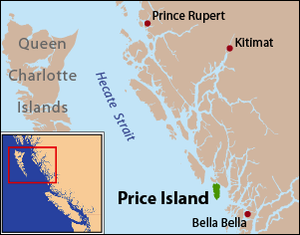
Price Island (British Columbia)
Encyclopedia
Island
An island or isle is any piece of sub-continental land that is surrounded by water. Very small islands such as emergent land features on atolls can be called islets, cays or keys. An island in a river or lake may be called an eyot , or holm...
on the coast of the Canadian province
Provinces and territories of Canada
The provinces and territories of Canada combine to make up the world's second-largest country by area. There are ten provinces and three territories...
of British Columbia
British Columbia
British Columbia is the westernmost of Canada's provinces and is known for its natural beauty, as reflected in its Latin motto, Splendor sine occasu . Its name was chosen by Queen Victoria in 1858...
. It is located at the southeastern end of Hecate Strait
Hecate Strait
Hecate Strait is a wide but shallow strait between the Haida Gwaii and the mainland of British Columbia, Canada. It merges with Queen Charlotte Sound to the south and Dixon Entrance to the north...
and the northeastern end of Queen Charlotte Sound. The southermost point of Price Island, called Day Point, is used to delineated the boundary between Hecate Strait and Queen Charlotte Sound. Milbanke Sound
Milbanke Sound
Milbanke Sound is a sound on the coast of the Canadian province of British Columbia, extending east from Queen Charlotte Sound, with Price Island on the west, Swindle Island on the north, and the Bardswell Group of islands on the south. Milbanke Sound is one of the open sea portions of the Inside...
is just to the south of Price Island. Laredo Sound is just north. Swindle Island
Swindle Island
Swindle Island is an island on the North Coast of the Canadian province of British Columbia. It is located south of Princess Royal Island on the Inside Passage shipping route. Price Island lies just south of Swindle Island...
lies just north of Price Island. The main Inside Passage
Inside Passage
The Inside Passage is a coastal route for oceangoing vessels along a network of passages which weave through the islands on the Pacific coast of North America. The route extends from southeastern Alaska, in the United States, through western British Columbia, in Canada, to northwestern Washington...
route crosses Milbanke Sound and enters Finlayson Channel
Finlayson Channel
Finlayson Channel is a channel of the British Columbia Coast. It is a northern extension of Milbanke Sound. To its west are Swindle and Sarah Islands, to its east Roderick, Susan and Dowager Islands. It was first charted in 1793 by James Johnstone, one of George Vancouver's lieutenants during his...
just east of Price Island. Price Island is located within the Kitimat-Stikine Regional District.
Price Island is 23 kilometres (14.3 mi) long and 10 kilometres (6.2 mi) wide. It is 122 square kilometres (47.1 sq mi) in area.
Price Island was named in 1866 by Captain Daniel Pender
Daniel Pender
Daniel Pender was a Royal Navy Staff Commander, later Captain, who surveyed the Coast of British Columbia aboard HMS Plumper, HMS Hecate and the Beaver from 1857 to 1870.-Legacy:...
of the Royal Navy, after Captain John Adolphus Pope Price, also of the Royal Navy.
Price Island is part of a volcanic center called the Milbanke Sound Group
Milbanke Sound Group
The Milbanke Sound Group, also called the Milbanke Sound Cones, is an enigmatic group of five small basaltic volcanoes in the Kitimat Ranges of the Coast Mountains in British Columbia, Canada. Named for Milbanke Sound, this volcanic group straddles on at least four small uninhabited islands,...
which includes several monogenetic
Monogenetic volcanic field
A monogenetic volcanic field is a volcanic field of small, scattered volcanic vents. These volcanic fields, containing numerous monogenetic volcanoes, are noted for having only one short eruptive event at each volcano, as opposed to regular volcanoes that have several eruptions from the same vent...
cinder cone
Cinder cone
According to the , Cinder Cone is the proper name of 1 cinder cone in Canada and 7 cinder cones in the United States:In Canada: Cinder Cone In the United States:...
s. Holocene
Holocene
The Holocene is a geological epoch which began at the end of the Pleistocene and continues to the present. The Holocene is part of the Quaternary period. Its name comes from the Greek words and , meaning "entirely recent"...
basalt
Basalt
Basalt is a common extrusive volcanic rock. It is usually grey to black and fine-grained due to rapid cooling of lava at the surface of a planet. It may be porphyritic containing larger crystals in a fine matrix, or vesicular, or frothy scoria. Unweathered basalt is black or grey...
ic lava flows from Price Island overlie adjacent beach deposits.