

Garibaldi Volcanic Belt
Encyclopedia
The Garibaldi Volcanic Belt, also called the Canadian Cascade Arc, is a northwest-southeast trending volcanic chain in the Pacific Ranges
of the Coast Mountains
that extends from Watts Point
in the south to the Ha-Iltzuk Icefield
in the north. This chain of volcanoes is located in southwestern British Columbia
, Canada
. It forms the northernmost segment of the Cascade Volcanic Arc
, which includes Mount St. Helens
and Mount Baker
. Most volcanoes of the Garibaldi chain are dormant stratovolcano
es and subglacial volcano
es that have been eroded by glacial ice. Less common volcanic landforms include cinder cone
s, volcanic plug
s, lava dome
s and caldera
s. These diverse formations were created by different styles of volcanic activity, including Peléan
and Plinian eruption
s.
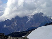
Eruptions along the length of the chain have created at least three major volcanic zones. The first began in the Powder Mountain Icefield
4.0 million years ago. The Mount Cayley
massif began its formation during this period. Multiple eruptions from 2.2 million to 2,350 years ago created the Mount Meager
massif, and eruptions 1.3 million to 9,300 years ago formed Mount Garibaldi
and other volcanoes in the Garibaldi Lake
area. These major volcanic zones lie in three echelon segments, referred to as the northern, central, and southern segments. Each segment contains one of the three major volcanic zones. Apart from these large volcanic zones, two large poorly studied volcanic complexes lie at the northern end of the Pacific Ranges, namely Silverthrone Caldera
and Franklin Glacier Volcano
. They are considered to be part of the Garibaldi Volcanic Belt, but their tectonic
relationships to other volcanoes in the Garibaldi chain are unclear because of minimal studies.
s were constructed along the Southern Coast of British Columbia. This includes the east-west trending Alert Bay Volcanic Belt
on northern Vancouver Island
and the Pemberton Volcanic Belt
along the coastal mainland. The Pemberton Belt began its formation when the former Farallon Plate
was subducting
under the British Columbia Coast
29 million years ago during the Oligocene
epoch
. At this time, the north-central portion of the Farallon Plate was just starting to subduct under the U.S. state of California, splitting it into northern and southern sections. Between 18 and five million years ago during the Miocene
period, the northern remnant of the Farallon Plate fractured into two tectonic plates, known as the Gorda
and Juan de Fuca
plates. After this breakup, subduction of the Juan de Fuca Plate might have been coincident with the northern end of Vancouver Island eight million years ago during the late Miocene period. This is when the Alert Bay Belt became active. A brief interval of plate motion adjustment about 3.5 million years ago may have triggered the generation of basalt
ic magma
along the descending plate edge. This eruptive period postdates the formation of the Garibaldi Belt and evidence for more recent volcanism
in the Alert Bay Belt has not been found, indicating that volcanism in the Alert Bay Belt is likely extinct.
Bedrock
under the Garibaldi chain consists of granitic
and dioritic
rocks of the Coast Plutonic Complex, which makes up much of the Coast Mountains. This is a large batholith
complex that was formed when the Farallon and Kula
plates were subducting along the western margin of the North American Plate during the Jurassic
and Tertiary
periods. It lies on island arc
remnants, oceanic plateau
s and clustered continental margin
s that were added along the western margin of North America between the Triassic
and Cretaceous
periods.
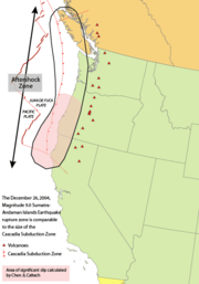
The Garibaldi Belt has formed in response to ongoing subduction of the Juan de Fuca Plate under the North American Plate
at the Cascadia subduction zone along the British Columbia Coast. This is a 1094 km (679.8 mi) long fault zone running 80 km (49.7 mi) off the Pacific Northwest
from Northern California
to southwestern British Columbia. The plates move at a relative rate of over 10 mm (0.393700787401575 in) per year at a somewhat oblique angle to the subduction zone. Because of the very large fault area, the Cascadia subduction zone can produce large earthquake
s of magnitude
7.0 or greater. The interface between the Juan de Fuca and North American plates remains locked for periods of roughly 500 years. During these periods, stress builds up on the interface between the plates and causes uplift of the North American margin. When the plate finally slips, the 500 years of stored energy are released in a mega-earthquake.
Unlike most subduction zones worldwide, there is no deep oceanic trench
present in the bathymetry of the continental margin
in Cascadia. This is because the mouth of the Columbia River
empties directly into the subduction zone and deposits silt at the bottom of the Pacific Ocean
to bury the oceanic trench. Massive floods from prehistoric Glacial Lake Missoula
during the Late Pleistocene
also deposited massive amounts of sediment
into the trench. However, in common with other subduction zones, the outer margin is slowly being compressed, similar to a giant spring. When the stored energy is suddenly released by slippage across the fault at irregular intervals, the Cascadia subduction zone can create very large earthquakes, such as the magnitude 9.0 Cascadia earthquake on January 26, 1700. However, earthquakes along the Cascadia subduction zone are fewer than expected and there is evidence of a decline in volcanic activity over the past few million years. The probable explanation lies in the rate of convergence between the Juan de Fuca and North American plates. These two tectonic plates currently converge 3 cm (1.2 in) to 4 cm (1.6 in) per year. This is only about half the rate of convergence of seven million years ago.
Scientists have estimated that there have been at least 13 significant earthquakes along the Cascadia subduction zone in the past 6,000 years. The most recent, the 1700 Cascadia earthquake, was recorded in the oral traditions of the First Nations people on Vancouver Island. It caused considerable tremors and a massive tsunami
that traveled across the Pacific Ocean. The significant shaking associated with this earthquake demolished houses of the Cowichan Tribes
on Vancouver Island and caused several landslides. Shaking due to this earthquake made it too difficult for the Cowichan people to stand, and the tremors were so lengthy that they were sickened. The tsunami created by the earthquake ultimately devastated a winter village at Pachena Bay, killing all the people that lived there. The 1700 Cascadia earthquake caused near-shore subsidence, submerging marsh
es and forests on the coast that were later buried under more recent debris.
Many thousand years of dormancy are expected between large explosive eruption
s of volcanoes in the Garibaldi Belt. A possible explanation for the lower rates of volcanism in the Garibaldi chain is that the associated terrain
is being compressed in contrast to the more southern portions of the Cascade Arc. In continental rift
zones, magma is able to push its way up through the Earth's crust rapidly along faults, providing less chance for differentiation. This is likely the case south of Mount Hood
to the California
border and east-southeast of the massive Newberry shield volcano
adjacent to the Cascade Range
in central Oregon
because the Brothers Fault Zone
lies in this region. This rift zone might explain the massive amounts of basaltic lava in this part of the central Cascade Arc. A low convergence rate in a compressional setting with massive stationary bodies of magma under the surface could explain the low volume and differentiated magmas throughout the Garibaldi Volcanic Belt. In 1958, Canadian volcanologist Bill Mathews
proposed there could be a connection between regional glaciation of the North American continent during glacial period
s and higher rates of volcanic activity during regional glacial unload of the continent. However, this is hard to predict due to the infrequent geological record in this region. But there is specific data, including the temporal grouping of eruptions synglacially or just postglacial within the Garibaldi Belt, that suggests this could be probable.
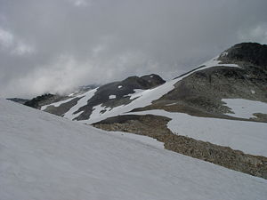
 Dominating the Garibaldi chain are volcanoes and other volcanic formations that formed during periods of intense glaciation. This includes flow-dominated tuya
s, subglacial lava domes and ice-marginal lava flows. Flow-dominated tuyas differ from the typical basaltic tuyas throughout British Columbia in that they are composed of piles of flat-lying lava flows and lack hyaloclastite
and pillow lava
. They are interpreted to have formed as a result of magma intruding into and melting a vertical hole through adjacent glacial ice that eventually breached the surface of the glacier. As this magma ascends, it ponds and spreads into horizontal layers. Lava domes that were formed mainly during subglacial activity comprise steep flanks made of intense columnar joints and volcanic glass
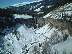
. Ice-marginal lava flows form when lava erupts from a subaerial vent and ponds against glacial ice. The Barrier
, a lava dam
impounding Garibaldi Lake
in the southern segment, is the best represented ice-marginal lava flow in the Garibaldi Belt.
Flow-dominated tuyas and the absence of subglacial fragmental deposits are two uncommon glaciovolcanic features in the Garibaldi chain. This is due to their different lava compositions and decline of direct lava-water contact during volcanic activity. The lava composition of these volcanic edifies changes their structure because eruption temperatures are lower than those associated with basaltic activity and lava containing silica increases thickness and glass differentiation temperatures. As a result, subglacial volcanoes that erupt silicic content melt less qualities of ice and are not as likely to contain water close to the volcanic vent. This forms volcanoes with structures that display their relationship with the regional glaciation. The surrounding landscape also changes the flow of meltwater, favouring lava to pond within valleys dominated by glacial ice. And if the edifice is eroded, it could change the prominence of fragmental glaciovolcanic deposits as well.
 On the eastern side of Howe Sound
lies the southernmost zone of volcanic activity in the Garibaldi chain. This zone, known as the Watts Point volcanic centre
, is a small outcrop
of volcanic rock
that is a portion of a subglacial volcano. The outcrop covers an area of about 0.2 square kilometre and an eruptive volume of roughly 0.02 km³ (0.00479825517208573 cu mi). The location is heavily forested and the BC Rail mainline passes through the lower portion of the outcrop about 40 m (131.2 ft) above sea level. It represents a feature in the Squamish volcanic field.
Mount Garibaldi, one of the larger volcanoes in the southern Garibaldi Belt with a volume of 6.5 km³ (1.6 cu mi), is composed of dacite
lavas that were erupted in the past 300,000 years. It was constructed when volcanic material erupted onto a portion of the Cordilleran Ice Sheet
during the Pleistocene period. This created the unique asmmetrical shape of the mountain. Successive landslides on Garibaldi's flanks occurred after glacial ice of the Cordilleran Ice Sheet retreated. Subsequent volcanism about 9,300 years ago produced a 15 km (9.3 mi) long dacite lava flow from Opal Cone
on Garibaldi's southeastern flank. This is unusually long for a dacite flow, which commonly travel only short distances from a volcanic vent due to their high viscosity. The Opal Cone lava flow represents the most recent volcanic feature at Mount Garibaldi.
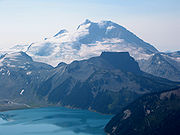
On the western shore of Garibaldi Lake, Mount Price represents a stratovolcano with an elevation of 2050 m (6,725.7 ft). It was constructed during three periods of activity. The first phase 1.2 million years ago formed a hornblende
andesite
stratovolcano on the drift-covered floor of a circular basin. After this stratovolcano was constructed, volcanism moved to the west where a series of andesite-dacite lava flows and pyroclastic flows were extruded during a period of Peléan activity 300,000 years ago. This created the 2050 m (6,725.7 ft) high cone of Mount Price, which was later buried under glacial ice. Before Mount Price was overridden by glacial ice, volcanic activity took place on its northern flank where a satellite vent is present. Renewed activity took place at Clinker Peak
on the western flank of Mount Price 9,000 years ago. This produced the Rubble Creek and Clinker Ridge
andesite lava flows that extend 6 km (3.7 mi) to the northwest and southwest. After these flows traveled 6 km (3.7 mi), they were dammed against glacial ice to form an ice-marginal lava flow more than 250 m (820.2 ft) thick known as The Barrier.
 Cinder Cone
on the north shore of Garibaldi Lake is a cinder cone partly engulfed by the Helmet Glacier. It consists of volcanic ash, lapilli
and dispersed ropy and lava bomb segments that bring the cone's prominence to 500 m (1,640.4 ft). Its minimal degree of erosion indicates that it might have erupted in the past 1,000 years. A series of basaltic andesite
flows were erupted from Cinder Cone about 11,000 years ago that traveled into a deep north trending U-shaped valley on the eastern flank of Black Tusk
. Subsequent volcanism produced another sequence of basaltic lava flows 4,000 years ago that flowed in the same glacial valley.
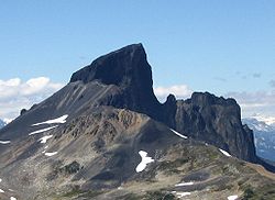
Black Tusk, a black pinnacle of volcanic rock on the northwestern shore of Garibaldi Lake, is the glacially eroded remnant of a much larger volcano that formed during two periods of volcanic activity. The first between 1.1 and 1.3 million years ago erupted hornblende andesite lava flows and tuffs. These volcanics compose mountain ridges southwest, southeast and northwest of the prime volcanic structure. Subsequent erosion demolished the newly formed volcano. This ultimately exposed the roots of the cone, which currently form the rugged edifice of Black Tusk. After the cone was eroded, a series of hypersthene andesite lava flows were erupted between 0.17 and 0.21 million years ago. These end at adjacent ice-marginal lava flows that form 100 m (328.1 ft) cliffs. This eruptive phase also produced a lava dome that comprises the current 2316 m (7,598.4 ft) high pinnacle. Consequently, the regional Late Pleistocene
ice sheet carved a deep north-trending U-shaped valley into the eastern flank of the second-stage cone. Here, subsequent lava flows from Cinder Cone filled the valley.
, an extensively eroded volcanio containing a north-south trending ridge. It is one of the older volcanic features in the central Garibaldi chain. Its volcanics are undated, but its large amount of dissection and evidence of glacai ice overriding the volcano indicates that it formed more than 75,000 years ago before the Wisconsinan Glaciation
. Therefore, volcanism at Mount Fee does not display evidence of interaction with glacial ice. The remaining product from Fee's earliest volcanic activity is a minor portion of pyroclastic rock
. This is evidence of explosive volcanism from Fee's eruptive history, as well as its first volcanic event. The second volcanic event produced a sequence of lavas and breccias on the eastern flank of the main ridge. These volcanics were likely placed when a sequence of lava flows and broken lava fragments erupted from a volcanic vent and moved down the flanks during the construction of a large volcano. Following extensive dissection, renewed volcanism produced a viscous series of lava flows forming its narrow, flat-topped, steep-sided northern limit and the northern end of the main ridge. The conduit for which these lava flows originated from was likely vertical in structure and intruded through older volcanics deposited during Fee's earlier volcanic events. This volcanic event was also followed by a period of erosion, and likely one or more glacial periods. Extensive erosion following the last volcanic event at Mount Fee has created the rugged north-south trending ridge that currently forms a prominent landmark.
Ember Ridge, a volcanic mountain ridge between Tricouni Peak
and Mount Fee, consists of at least eight lava domes composed of andesite. They were likely formed between 25,000 and 10,000 years ago when lava erupted beneath glacial ice of the Fraser Glaciation. Their current structures are comparable to their original forms due to the minimal degree of erosion. As a result, the domes display the shaps and columnar joints typical of subglacial volcanoes. The random shaps of the Ember Ridge domes are the result of erupted lava taking advantage of former ice pockets, eruptions taking place on uneven surfaces, subsidence of the domes during volcanic activity to create rubble and separation of older columnar units during more recent eruptions. The northern dome, known as Ember Ridge North, covers the summit and eastern flank of a mountain ridge. It comprises at least one lava flow that reaches a thickness of 100 m (328.1 ft), as well as the thinnest columnar units in the Mount Cayley volcanic field. The small size of the columnar joints indicates that the erupted lava was cooled immediately and are mainly located on the dome's summit. Ember Ridge Northeast, the smallest subglacial dome of Ember Ridge, comprises one lava flow that has a thickness no more than 40 m (131.2 ft). Ember Ridge Northwest, the most roughly circular subglacial dome, comprises at least one lava flow. Ember Ridge Southeast is the most complex of the Ember Ridge domes, consisting of a series of lava flows with a thickness of 60 m (196.9 ft). It is also the only Ember Ridge dome that contains large amounts of rubble. Ember Ridge Southwest comprises at least one lava flow that reaches a thickness of 80 m (262.5 ft). It is the only subglacial dome of Ember Ridge that contains hyaloclastite. Ember Ridge West comprises only one lava flow that reaches a thickness of 60 m (196.9 ft).
 To the northwest, the Mount Cayley massif constitutes the largest and most persistent volcano in the central Garibaldi Belt. It is a highly eroded stratovolcano composed of dacite and rhyodacite
lava that was deposited during three phases of volcanic activity. The first eruptive phase started about four million years ago with the eruption of dacite lava flows and pyroclastic rock. This resulted in the creation of the Mount Cayley proper. Subsequent volcanism during this volcanic phase constructed a significant lava dome. This acts like a volcanic plug and composes the lava spine
s that currently form pinnacles on Cayley's rugged summit. After the Mount Cayley proper was constructed, lava flows, tephra
and welded dacite rubble were erupted. This second phase of activity million years ago resulted in the creation of the Vulcan's Thumb
, a craggy volcanic ridge on the southern flank of Mount Cayley proper. Lengthy dissection from an extended period of erosion demolished much of the original stratovolcano. Volcanic activity after this prolonged period of erosion produced thick dacite lava flows from parasitic vents 300,000 years ago that extended into the Turbid
and Shovelnose Creek
valleys near the Squamish River. This subsequently created two minor parasitic lava domes 200,000 years ago. These three volcanic events are in contrast to several others around Cayley in that they do not show signs of interaction with glacial ice.
Pali Dome
, an eroded volcano north of Mount Cayley, consists of two geological units. Pail Dome East is composed of a mass of andesite lava flows and small amounts of pyroclastic material. It lies on the eastern portion of the large glacial icefield that covers much of the Mount Cayley volcanic field. Much of the lava flows form gentle topography at high elevations but terminate in finely jointed vertical cliffs at low elevations. The first volcanic activity likely occurred about 25,000 years ago, but it could also be significantly older. The most recent volcanic activity produced a series of lava flows that were erupted when the vent area was not covered by glacial ice. However, the flows show evidence of interaction with glacial ice in their lower units. This indicates that the lavas were erupted about 10,000 years ago during the waning stages of the Fraser Glaciation. The ice-marginal lava flows reach thicknesses of up to 100 m (328.1 ft). Pali Dome West consists of at least three andesite lava flows and small amounts of pyroclastic material; its vent is presently buried under glacial ice. At least three eruptions have occurred at Pali Dome East. The age of the first volcanic eruption is unknown, but it could have occurred in the past 10,000 years. The second eruption produced a lava flow that was erupted when the vent area was not buried under glacial ice. However, the flow does show evidence of interaction with glacial ice at its lower unit. This indicates that the lavas were erupted during the waning stages of the Fraser Glaciation. The third and most recent eruption produced another lava flow that was largely erupted above glacial ice, but was probably constrained on its northern margin by a small glacier. Unlike the lava flow that was erupted during the second eruption, this lava flow was not impounded by glacial ice at its lower unit. This suggests that it erupted less than 10,000 years ago when the regional Fraser Glaciation retreated.
Cauldron Dome
, a subglacial volcano north of Mount Cayley, lies west of the massive glacier covering much the region. Like Pali Dome, it is composed of two geological units. Upper Cauldron Dome is a flat-topped, oval-shaped pile of at least five andesite lava flows that resembles a tuya. The five andesite flows are columnar jointed and were likely extruded through glacial ice. The latest volcanic activity might have occurred between 10,000 and 25,000 years ago when this area was still influenced by glacial ice of the Fraser Glaciation. Lower Cauldron Dome, the youngest unit comprising the entire Cauldron Dome subglacial volcano, consists of a flat-topped, steep-sided pile of andesite lava flows 1800 m (5,905.5 ft) long and a maximum thickness of 220 m (721.8 ft). These volcanics were extruded about 10,000 years ago during the waning stages of the Fraser Glaciation from a vent adjacent to upper Cauldron Dome that is currently buried under glacial ice.
 Lying at the northern portion of the Mount Cayley volcanic field is a subglacial volcano named Slag Hill
. At least two geologic units compose the edifice. Slag Hill proper consists of andesite lava flows and small amounts of pyroclastic rock. Lying on the western portion of Slag Hill is a lava flow that likely erupted less than 10,000 years ago due to the lack of features indicating volcano-ice interactions. The Slag Hill flow-dominated tuya 900 m (2,952.8 ft) northeast of Slag Hill proper consists of a flat-topped, steep-sided pile of andesite. It protrudes through remnants of volcanic material erupted from the Slag Hill proper, but it represents a separate volcanic vent due to its geographical appearance. This small subglacial volcano possibly formed between 25,000 and 10,000 years ago throughout the waning stages of the Fraser Glaciation.
Ring Mountain, a flow-dominated tuya lying at the northern portion of the Mount Cayley volcanic field, consists of a pile of at least five andesite lava flows lying on a mountain ridge. Its steep-sided flanks reach heights of 500 m (1,640.4 ft) and are composed of volcanic rubble. This makes it impossible to measure its exact base elevation or how many lava flows constitute the edifice. With a summit elevation of 2192 m (7,191.6 ft), Ring Mountain had its last volcanic activity between 25,000 and 10,000 years ago when the Fraser Glaciation was close to its maximum. Northwest of Ring Mountain lies a minor andesite lava flow. Its chemistry is somewhat unlike other andesite flows comprising Ring Mountain, but it probably erupted from a volcanic vent adjacent to or at Ring Mountain. The part of it that lies higher in elevation contains some features that indicate lava-ice interactions, while the lower-elevation portion of it does not. Therefore, this minor lava flow was likely extruded after Ring Mountain formed but when glacial ice covered a broader area than it does currently, and that the lava flow extends beyond the region in which glacial ice existed at that time.
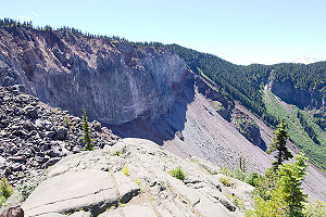
in the Garibaldi chain and British Columbia, as well as the most recent to erupt. It has a volume of 20 km³ (4.8 cu mi) and consists of an eroded stratovolcano, ranging in composition from andesite to rhyodacite. Several dissected lava domes and volcanic plugs are present on its glaciated summit, as well as a clearly defined volcanic crater
with a lava dome placed within it. At least eight volcanic vents compose the complex and have been the sources for volcanic activity throughout Meager's 2.2 million year history. A well-documented history of volcanism is present at Meager, with its most recent eruption about 2,350 years ago that was similar in character to the 1980 eruption of Mount St. Helens
and the continuous eruption of Soufrière Hills
on the island of Montserrat
. This is the largest recorded Holocene explosive eruption in Canada, originating from a volcanic vent on the northeastern flank of Plinth Peak
. It was Plinian in nature, sending an eruption column at least 20 km (12.4 mi) high into the stratosphere
. As prevailing winds carried ash of the column eastwards, it deposited across British Columbia and Alberta
. Subsequent pyroclastic flows were sent down Meager's flanks for 7 km (4.3 mi) and were later succeeded by the eruption of a lava flow that demolished many times. This created thick agglutinated rubble that successfully blocked the adjacent Lillooet River to form a lake. Subsequently, the breccia dam collapsed to produce a catastrophic flood that deposited house-sized boulders more than 1 km (0.621372736649807 mi) downstream. After the flood took place, a small dacite lava flow was erupted that later solidified to form a series of well-preserved columnar joints. This is the last phase of the 2350 BP eruption, and subsequent stream erosion has cut though this lava flow to form a waterfall.
A group of small volcanoes on the upper Bridge River
, known as the Bridge River Cones
, includes stratovolcanoes, volcanic plugs and lava flows. These volcanoes are unlike others throughout the Garibaldi Volcanic Belt in that they are mainly composed of volcanic rocks with mafic compositions, including alkaline basalt and hawaiite
. The different magma compositions might be related to a smaller degree of partial melting
in the Earth's mantle or a descending plate edge effect. The oldest volcano in the group, known as Sham Hill
, is a 60 m (196.9 ft) high volcanic plug with a potassium-argon date of one million years. It is about 300 m (984.3 ft) wide and its uncovered glaciated surface is strewn with glacial erratics. Its massive level rock columns were constructed inside the main volcanic vent of a stratovolcano that has since been reduced by erosion. To the southeast, the Salal Glacier volcanic complex
was constructed between 970,000 and 590,000 years ago. It consists of subaerial tephra and thin lava flow deposits that are surrounded by 100 m (328.1 ft) thick ice-ponded lava flows. These ice-marginal lava flows were created when lava ponded against glacial ice in the nearby valleys before the Wisconsin Glaciation
. North of the Salal Glacier complex lies a small basaltic stratovolcano named Tuber Hill
. It began to form about 600,000 years ago when adjacent valleys were filled by glacial ice. When lava flows were erupted from Tuber Hill, they interacted with the valley-filling glaciers on its southern flank and produced a glacial meltwater lake. Here, more than 150 m (492.1 ft) of stacked hyaloclastite, lahars and lacustrine tuff were deposited. A series of pillow lavas were also deposited during this eruptive period. The most recent volcanic activity in the Bridge River volcanic field produced a series of basaltic lava flows in the regional valleys that overlie till of the last glacial period. The age of these valley-filling lava flows is unknown but the presence of unconsolidated glacial till under the flows suggests that they are less than 1,500 years old.
To the northwest, the Franklin Glacier complex is a set of volcanic bedrock that encompasses an area 20 km (12.4 mi) long and 6 km (3.7 mi) wide. It has an elevation of over 2000 m (6,561.7 ft) and is largely destroyed by erosion. A series of dikes and subvolcanic
intrusion
s compose the complex, a few of which seem to represent vents for the overlying sequence of volcanic deposits. Volcanics include dacite breccia and small remnants of hornblende andesite lava flows associated with tuffs that reach 450 m (1,476.4 ft) thick. The complex is poorly known due to minimal studies, but potassium-argon dates
obtained from some of the subvolcanic intrusions indicate that Franklin formed during two volcanic events, each separated by about five million years of dormancy. The first event occurred between six and eight million years ago when volcanic activity in the Garibaldi Belt had not moved to its current location, but was becoming more aerially restricted within a large band to the east and west. During this period, volcanic activity in the Garibaldi Belt and other portions of the northern Cascade Arc took place mainly at the Franklin Glacier complex and in the Intermontane Belt
further east. When the Garibaldi Belt moved to its current location five million years ago, another volcanic event occurred at the Franklin complex. This final and most recent volcanic event occurred between two and three million years ago, about a million years after Mount Cayley to the south began its formation.
Silverthrone Caldera is the largest and best-preserved of the two caldera complexes in the northern Garibaldi chain, the other being the Franklin Glacier complex 55 km (34.2 mi) to the east-southeast. The caldera has a diameter of 20 km (12.4 mi) and contains breccia, lava flows and lava domes. Like Franklin to the east-southeast, the geology of Silverthrone is poorly known due to minimal studies. The region surrounding the Silverthrone complex is significantly jagged due to the mountainous terrain of the Coast Mountains. Near vertical flanks extend from near sea level to more than 3000 m (9,842.5 ft) in elevation. Silverthrone is significantly younger than the Franklin Glacier complex to the east-southeast and its volcanics likely have ages comparable to other volcanics throughout the Garibaldi chain. The oldest volcanics at the Silverthrone Caldera complex are composed of volcanic breccias, some of which became fused together by intense volcanic heat from when the deposits were first erupted. After these volcanics were deposited, a series of dacite, andesite and rhyolite lava flows were erupted upon volcanic breccia from the first volcanic phase. These eroded lava flows in total are 900 m (2,952.8 ft) thick. Volcanics in the lower portion of this series of lava flows give a potassium-argon date of 750,000 years while volcanics slightly above the lava flows are 400,000 years old. The most recent volcanic activity produced a series of andesite and basaltic andesite lava flows down Pashleth Creek and the Machmell
and Kingcome
river valleys. The lava flow extending from near Pashleth Creek to down the Machmell River valley is over 25 km (15.5 mi) in length. Its small amount of erosion indicates that it could be 1,000 years old or younger.

Paralleling the Garibaldi Belt to the northeast is a region composed of minor, but related basaltic lava flows. This zone, known as the Chilcotin Group, is interpreted to have formed as a result of back-arc basin
volcanism behind the Garibaldi Belt, in response to the ongoing subduction at the Cascadia subduction zone. Eruptions were most vigorous during two magmatic events, the first between six and ten million years ago and the other between two and three million years ago. A few volcanic eruptions have occurred in the Chilcotin Group in the past 1.6 million years.
The flat-lying lava plateau composing the Chilcotin Group covers an area of 25000 square kilometre and a volume of 1800 km³ (431.8 cu mi). It consists of several thin, flat-lying pāhoehoe lava flows that were extruded from a chain of low-profile shield volcano
es, which have since been eroded by Late Pleistocene glaciation to expose their gabbro
-bearing volcanic plugs. The Chilcotin lava plateau contains a maximum thickness of 140 m (459.3 ft) with at least 20 lava flows exposed in stratigraphic units. Specific lava flows normally extend over 1 km (0.621372736649807 mi) and reach a thickness of 10 m (32.8 ft). But in some areas, lava flows reach thicknesses of 70 m (229.7 ft).
A number of pillow lava and pillow breccia deposits are exposed throughout the Chilcotin Group. Pyroclastic fall
deposits, composed of lapilli, were erupted from volcanoes in the Garibaldi Belt and are overridden by subsequent basaltic lava flows. Remnants of lava flows from the first phase of volcanism between 16 and 14 million years ago outcrop adjacent to the margins of the current lava plateau, which consists largely of basalts that were erupted between six and ten million years ago. More recent lava flows are exposed in cliffs along the Fraser Canyon
. These were erupted during the Pliocene
period and the volcanic vents they were erupted from have not been discovered.
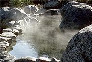 A series of hot spring
s adjacent to the Lillooet River valley, such as the Harrison
, Sloquet, Clear Creek and Skookumchuck springs, are not known to occur near areas with recent volcanic activity. Instead, many are located close to 16-26 million year old intrusions that are interpreted to be the roots of heavily eroded volcanoes. These volcanoes formed part of the Cascade Volcanic Arc during the Miocene period and their intrusive roots extend from the Fraser Valley
in the south to Salal Creek in the north. The relationship of these hot springs to the Garibaldi Belt is not clear. However, a few hot springs are known to exist in areas that have experienced relatively recent volcanic activity. About five hot springs exist in valleys near Mount Cayley and two small groups of hot springs are present at Mount Meager. The springs at Meager might be evidence of a shallow magma chamber beneath the surface. No hot springs are known to exist at Mount Garibaldi like those found at Mount Meager and Mount Cayley, although there is evidence of abnormal high heat flow at the adjacent Table Meadows and other locations. Abnormal warm water adjacent to Britannia Beach could be geothermal activity linked to the Watts Point volcanic zone.
was collected by the Squamish Nation for making knives, chisels, adze
s and other sharp tools in pre-contact times. This material appears in sites dated 10,000 years old up to protohistoric
time periods. The source for this material is found in upper parts of the mountainous terrain that surround Mount Garibaldi. At Opal Cone, lava of the Ring Creek flow was normally heated to cook food because its pumice
-like texture is able to maintain heat. It also did not break after it was used for a long period of time.
A large pumice outcrop adjacent to Mount Meager has been mined several times in the past, and extends more than 2000 m (6,561.7 ft) in length and 1000 m (3,280.8 ft) in width with a thickness of about 300 m (984.3 ft). The deposit was first hired by J. MacIsaac, who died in the late 1970s. In the mid 1970s the second hirer, W.H. Willes, investigated and mined the pumice. It was crushed, removed then stored close to the village of Pemberton
. Later, the bridge that was used to access the pumice deposit was washed out. Mining operations resumed in 1988 when the deposit was staked by L.B. Bustin. In 1990, the pumice outcrop was bought by D.R. Carefoot from the owners B. Chore and M. Beaupre. In a program from 1991 to 1992, workers evaluated the deposit for its properties as a construction material, absorber of oil and stonewash
. About 7500 cubic metre of pumice was mined in 1998 by the Great Pacific Pumice Incoporation.
The hot springs associated with Meager and Cayley have made these two volcanoes targets for geothermal explorations. At Mount Cayley, temperatures of 50 °C (122 °F) to more than 100 °C (212 °F) have been measured in shallow boreholes on its southwestern flank. Further north, geothermal exploration at Mount Meager has been undertaken by BC Hydro since the late 1970s. Bottom hole temperatures have been calculated at an average of 220 °C (428 °F) to 240 °C (464 °F), with 275 °C (527 °F) being the highest recorded temperature. This indicates that the area around Meager is a major geothermal site. The geothermal power is expected to run throughout Western Canada
and the likelihood of it extending into the western United States is probable.
. To the Squamish Nation, Mount Garibaldi is called Nch'kay. In their language it means "Dirty Place". This name of the mountain refers to the volcanic rubble in the area. This mountain, like others located in the area, is considered sacred as it plays an important part of their history. In their oral history
, they passed down a story of the flood covering the land. During this time, only two mountains peaked over the water, and Garibaldi was one of them. It was here that the remaining survivors of the flood latched their canoes to the peak and waited for the waters to subside. Black Tusk on the northwestern end of Garibaldi Lake and Mount Cayley northwest of Mount Garibaldi are called tak'takmu'yin tl'a in7in'axa7en in the Squamish language, which means "Landing Place of the Thunderbird". The Thunderbird
is a legendary creature
in North American indigenous peoples'
history and culture. The rocks that make up Black Tusk and Mount Cayley were said to have been burnt black by the Thunderbird's lightening.
 A number of volcanic features in the Garibaldi Belt are protected by provincial park
s. Garibaldi Provincial Park
at the southern end of the chain was established in 1927 to protect the abundant geological history, glaciated mountains and other natural resources in the region. It was named after the 2678 m (8,786.1 ft) stratovolcano Mount Garibaldi, which in turn was named after the Italian military and political leader Giuseppe Garibaldi
in 1860. To the northwest, Brandywine Falls Provincial Park
protects Brandywine Falls, a 70 m (229.7 ft) high waterfall composed of at least four basaltic lava flows with columnar joints. Its name origin is unclear, but it may have originated from two surveyors named Jack Nelson and Bob Mollison.
Like other volcanic zones in Canada, the Garibaldi Volcanic Belt is not monitored closely enough by the Geological Survey of Canada to ascertain how active its magma system is. This is partly because several volcanoes in the chain are located in remote regions and no major eruptions have occurred in Canada in the past few hundred years. As a result, volcano monitoring is less important than dealing with other natural processes, including tsunami
s, earthquakes and landslides. However, with the existence of earthquakes, further volcanism is expected and would probably have considerable effects, particularly in a region like southwestern British Columbia where the Garibaldi volcanoes are located in a highly populated area.
s of California and Oregon and about 20% of that within the U.S. state of Washington. As a result, the risk of eruptions throughout this part of the Cascade Arc is minor. Individual volcanoes and volcanic fields remain quiet for a long period of time and certain vents may never erupt again. However, considerable volcanic activity has taken place in the geologically recent past, most notably the explosive eruption that occurred at Mount Meager 2,350 years ago.
Jack Souther
, a leading authority on geothermal resources and volcanism in the Canadian Cordillera has stated, "at present the volcanoes of the Garibaldi Belt are quiet, presumed dead but still not completely cold. But the flare-up of Meager Mountain 2,500 years ago raises the question, 'Could it happen again?' Was the explosive eruption of Meager Mountain the last gasp of the Garibaldi Volcanic Belt or only the most recent event in its on-going life? The short answer is nobody really knows for sure....So just in case I sometimes do a quick check of the old hot-spots when I get off the Peak Chair.." Recent seismic imaging from Geological Survey of Canada employees supported lithoprobe studies in the region of Mount Cayley in which scientists found a large reflector interpreted to be a pool of molten rock roughly 15 km (9.3 mi) below the surface. The existence of hot springs at Mount Meager and Mount Cayley indicates that magmatic heat is still present beneath or near these volcanoes. This long history of volcanic activity along a still active plate boundary indicates that volcanic eruptions in the Garibaldi Belt have not ended and risks for future eruptions remain.
 The largest threat from volcanoes in the Garibaldi chain would likely be due to tephra released during explosive eruptions. Mount Meager in particular poses a major long-distance threat to communities throughout southern British Columbia and Alberta because of its explosive history. It is estimated that over 200 eruptions have occurred throughout the entire Cascade Volcanic Arc in the past 12,000 years, many of them in the United States. Many eruptions in the western United States have sent large amounts of tephra in southern British Columbia. However, all major cities in southwestern British Columbia with populations more than 100,000 are located west of the Garibaldi Volcanic Belt and prevailing winds travel eastwards. Therefore, these communities are less likely to have large amounts of tephra. In the Lower Mainland
, a 10 cm (3.9 in) thick layer of volcanic ash can deposit once every 10,000 years and 1 cm (0.393700787401575 in) once every 1,000 years. More minor amounts of volcanic ash can be expected more commonly. During Mount St. Helens' eruption in 1980, 1 mm (0.0393700787401575 in) of tephra was deposited from southeastern British Columbia to Manitoba
.
Even though all major cities in southwestern British Columbia are located west of the Garibaldi chain, future eruptions from Mount Garibaldi are expected to have significant impacts on the adjacent townships of Squamish
and Whistler
. An eruption column released during Peléan activity would discharge large amounts of tephra that would endanger aircraft. Tephra may also melt the large sheets of glacial ice east of Garibaldi and cause floods. This could later endanger water supplies from Pitt Lake
and fisheries on the Pitt River
. An explosive eruption and the associated tephra may also create temporary or longer-term water supply difficulties for Vancouver and most of southern British Columbia. The water reservoir for the Greater Vancouver
drainage area is south of Mount Garibaldi.
and Devastator Peak
in the past 10,000 years that have reached more than 10 km (6.2 mi) downstream in the Lillooet River valley. At least two significant landslides from the southern flank of Pylon Peak 8,700 and 4,400 years ago dumped volcanic debris into the adjacent valley of Meager Creek
. More recently, a large landslide from Devastation Glacier
buried and killed a group of four geologists on July 22, 1975. The estimated volume of this landslide is 13000000 cubic metre. A considerable landslide as large as Meager's largest throughout the Holocene would likely produce a lahar that would devastate most of the growth in the Lillooet River valley. If such an event would occur without it being identified by authorities who would send out a public warning, it would kill hundreds or even thousands of residents. Because of this, computer programs would be able to identify the approaching information and activate an automatic notice when a large lahar is identified. A similar system for identifying such lahars exists at Mount Rainier
in the U.S. state of Washington.
Large landslides from Mount Cayley have occurred on its western flank, including a major debris avalanche about 4,800 years ago that dumped an areal extent of 8 square kilometre of volcanic material into the adjacent valley bottom. This blocked the Squamish River
for a long period of time. Although there are no known eruptions from Mount Cayley in the past 10,000 years, it is associated with a group of hot springs. Evans (1990) has indicated that a number of landslides and debris flows at Mount Cayley in the past 10,000 years might have been caused by volcanic activity. Since the 4,800 BP landslide, a number of more minor landslides have occurred at it. In 1968 and 1983, a series of landslides took place that caused considerable damage to logging roads and forest stands, but did not result in any casualties.
s. When lava flows over large areas of snow, it creates meltwater. This can produce lahars that could flow further than the associated lavas. If water were to enter a volcanic vent that is erupting basaltic lava, it may create a massive explosive eruption. These explosions are generally more extreme than those during normal basaltic eruptions. Therefore, the existence of water, snow, or glacial ice at a volcanic vent would increase the risk of an eruption having a large impact on the surrounding region. Subglacial eruptions have also caused catastrophic glacial outburst floods.
Pacific Ranges
The Pacific Ranges are the southernmost subdivision of the Coast Mountains portion of the Pacific Cordillera. Located entirely within British Columbia, Canada, they run northwest from the lower stretches of the Fraser River to Bella Coola, north of which are the Kitimat Ranges.The Pacific Ranges...
of the Coast Mountains
Coast Mountains
The Coast Mountains are a major mountain range, in the Pacific Coast Ranges, of western North America, extending from southwestern Yukon through the Alaska Panhandle and virtually all of the Coast of British Columbia. They are so-named because of their proximity to the sea coast, and are often...
that extends from Watts Point
Watts Point
Watts Point is a point in southwestern British Columbia, Canada, located on the eastern side of Howe Sound northwest of Britannia Beach....
in the south to the Ha-Iltzuk Icefield
Ha-Iltzuk Icefield
The Ha-Iltzuk Icefield is an icefield in the central Pacific Ranges of the Coast Mountains in British Columbia, Canada. It is the largest icefield in the Coast Mountains south of the Alaska Panhandle, with an area of . It is located on the west side of the Klinaklini River and the Waddington Range...
in the north. This chain of volcanoes is located in southwestern British Columbia
British Columbia
British Columbia is the westernmost of Canada's provinces and is known for its natural beauty, as reflected in its Latin motto, Splendor sine occasu . Its name was chosen by Queen Victoria in 1858...
, Canada
Canada
Canada is a North American country consisting of ten provinces and three territories. Located in the northern part of the continent, it extends from the Atlantic Ocean in the east to the Pacific Ocean in the west, and northward into the Arctic Ocean...
. It forms the northernmost segment of the Cascade Volcanic Arc
Cascade Volcanoes
The Cascade Volcanoes are a number of volcanoes in a volcanic arc in western North America, extending from southwestern British Columbia through Washington and Oregon to Northern California, a distance of well over 700 mi ...
, which includes Mount St. Helens
Mount St. Helens
Mount St. Helens is an active stratovolcano located in Skamania County, Washington, in the Pacific Northwest region of the United States. It is south of Seattle, Washington and northeast of Portland, Oregon. Mount St. Helens takes its English name from the British diplomat Lord St Helens, a...
and Mount Baker
Mount Baker
Mount Baker , also known as Koma Kulshan or simply Kulshan, is an active glaciated andesitic stratovolcano in the Cascade Volcanic Arc and the North Cascades of Washington State in the United States. It is the second-most active volcano in the range after Mount Saint Helens...
. Most volcanoes of the Garibaldi chain are dormant stratovolcano
Stratovolcano
A stratovolcano, also known as a composite volcano, is a tall, conical volcano built up by many layers of hardened lava, tephra, pumice, and volcanic ash. Unlike shield volcanoes, stratovolcanoes are characterized by a steep profile and periodic, explosive eruptions...
es and subglacial volcano
Subglacial volcano
A subglacial volcano, also known as a glaciovolcano, is a volcanic form produced by subglacial eruptions or eruptions beneath the surface of a glacier or ice sheet which is then melted into a lake by the rising lava...
es that have been eroded by glacial ice. Less common volcanic landforms include cinder cone
Cinder cone
According to the , Cinder Cone is the proper name of 1 cinder cone in Canada and 7 cinder cones in the United States:In Canada: Cinder Cone In the United States:...
s, volcanic plug
Volcanic plug
A volcanic plug, also called a volcanic neck or lava neck, is a volcanic landform created when magma hardens within a vent on an active volcano. When forming, a plug can cause an extreme build-up of pressure if volatile-charged magma is trapped beneath it, and this can sometimes lead to an...
s, lava dome
Lava dome
|250px|thumb|right|Image of the [[rhyolitic]] lava dome of [[Chaitén Volcano]] during its 2008–2009 eruption.In volcanology, a lava dome is a roughly circular mound-shaped protrusion resulting from the slow extrusion of viscous lava from a volcano...
s and caldera
Caldera
A caldera is a cauldron-like volcanic feature usually formed by the collapse of land following a volcanic eruption, such as the one at Yellowstone National Park in the US. They are sometimes confused with volcanic craters...
s. These diverse formations were created by different styles of volcanic activity, including Peléan
Pelean eruption
Peléan eruptions are a type of volcanic eruption. They can occur when viscous magma, typically of rhyolitic or andesitic type, is involved, and share some similarities with Vulcanian eruptions. The most important characteristics of a Peléan eruption is the presence of a glowing avalanche of hot...
and Plinian eruption
Plinian eruption
Plinian eruptions, also known as 'Vesuvian eruptions', are volcanic eruptions marked by their similarity to the eruption of Mount Vesuvius in AD 79 ....
s.
Eruptions along the length of the chain have created at least three major volcanic zones. The first began in the Powder Mountain Icefield
Powder Mountain Icefield
The Powder Mountain Icefield, also called the Powder Mountain Icecap and the Cayley Icefield, is a glacial field in the Pacific Ranges of southwestern British Columbia, Canada, about west of Whistler and about north of Vancouver...
4.0 million years ago. The Mount Cayley
Mount Cayley
Mount Cayley is a potentially active stratovolcano in Squamish-Lillooet Regional District of southwestern British Columbia, Canada. Located north of Squamish and west of Whistler in the Pacific Ranges of the Coast Mountains, it rises above the Squamish River to the west and above the Cheakamus...
massif began its formation during this period. Multiple eruptions from 2.2 million to 2,350 years ago created the Mount Meager
Mount Meager
Mount Meager, originally known as Meager Mountain, is a complex volcano in the Sea-to-Sky Corridor of southwestern British Columbia, Canada. It is located north of Vancouver at the northern end of the Pemberton Valley. Part of the Cascade Volcanic Arc of western North America, its summit is above...
massif, and eruptions 1.3 million to 9,300 years ago formed Mount Garibaldi
Mount Garibaldi
Mount Garibaldi is a potentially active stratovolcano in the Sea to Sky Country of British Columbia, north of Vancouver, Canada. Located in the southernmost Coast Mountains, it is one of the most recognized peaks in the South Coast region, as well as British Columbia's best known volcano...
and other volcanoes in the Garibaldi Lake
Garibaldi Lake
The Garibaldi Lake volcanic field is a volcanic field, located in British Columbia, Canada. It was formed by a group of nine small andesitic stratovolcanoes and basaltic andesite vents in the scenic Garibaldi Lake area immediately north of Mount Garibaldi was formed during the late Pleistocene and...
area. These major volcanic zones lie in three echelon segments, referred to as the northern, central, and southern segments. Each segment contains one of the three major volcanic zones. Apart from these large volcanic zones, two large poorly studied volcanic complexes lie at the northern end of the Pacific Ranges, namely Silverthrone Caldera
Silverthrone Caldera
The Silverthrone Caldera is a potentially active caldera complex in southwestern British Columbia, Canada, located over northwest of the city of Vancouver and about west of Mount Waddington in the Pacific Ranges of the Coast Mountains. The caldera is one of the largest of the few calderas in...
and Franklin Glacier Volcano
Franklin Glacier Volcano
Franklin Glacier Volcano is a deeply eroded and huge long and wide caldera complex in southwestern British Columbia, Canada, located east-southeast of the Silverthrone Caldera in the Hoodoo Creek and Franklin Glacier area on the northwest flank of the Waddington Massif of the Pacific Ranges...
. They are considered to be part of the Garibaldi Volcanic Belt, but their tectonic
Tectonics
Tectonics is a field of study within geology concerned generally with the structures within the lithosphere of the Earth and particularly with the forces and movements that have operated in a region to create these structures.Tectonics is concerned with the orogenies and tectonic development of...
relationships to other volcanoes in the Garibaldi chain are unclear because of minimal studies.
Background
Prior to Garibaldi Belt formation, a number of older, but related volcanic beltVolcanic belt
A volcanic belt is a large volcanically active region. Other terms are used for smaller areas of activity, such as volcanic fields. Volcanic belts are found above zones of unusually high temperature where magma is created by partial melting of solid material in the Earth's crust and upper mantle....
s were constructed along the Southern Coast of British Columbia. This includes the east-west trending Alert Bay Volcanic Belt
Alert Bay Volcanic Belt
The Alert Bay Volcanic Belt is a heavily eroded Neogene volcanic belt in northern Vancouver Island, British Columbia, Canada. The belt is now north of the Nootka Fault, but may have been directly above the fault at the time it last erupted...
on northern Vancouver Island
Vancouver Island
Vancouver Island is a large island in British Columbia, Canada. It is one of several North American locations named after George Vancouver, the British Royal Navy officer who explored the Pacific Northwest coast of North America between 1791 and 1794...
and the Pemberton Volcanic Belt
Pemberton Volcanic Belt
The Pemberton Volcanic Belt is an eroded Oligocene volcanic belt at a low angle near Mount Meager, British Columbia, Canada. The Garibaldi and Pemberton volcanic belts appear to merge into a single belt, although the Pemberton is older than the Garibaldi Volcanic Belt...
along the coastal mainland. The Pemberton Belt began its formation when the former Farallon Plate
Farallon Plate
The Farallon Plate was an ancient oceanic plate, which began subducting under the west coast of the North American Plate— then located in modern Utah— as Pangaea broke apart during the Jurassic Period...
was subducting
Subduction
In geology, subduction is the process that takes place at convergent boundaries by which one tectonic plate moves under another tectonic plate, sinking into the Earth's mantle, as the plates converge. These 3D regions of mantle downwellings are known as "Subduction Zones"...
under the British Columbia Coast
British Columbia Coast
The British Columbia Coast or BC Coast is Canada's western continental coastline on the Pacific Ocean. The usage is synonymous with the term West Coast of Canada....
29 million years ago during the Oligocene
Oligocene
The Oligocene is a geologic epoch of the Paleogene Period and extends from about 34 million to 23 million years before the present . As with other older geologic periods, the rock beds that define the period are well identified but the exact dates of the start and end of the period are slightly...
epoch
Epoch (geology)
An epoch is a subdivision of the geologic timescale based on rock layering. In order, the higher subdivisions are periods, eras and eons. We are currently living in the Holocene epoch...
. At this time, the north-central portion of the Farallon Plate was just starting to subduct under the U.S. state of California, splitting it into northern and southern sections. Between 18 and five million years ago during the Miocene
Miocene
The Miocene is a geological epoch of the Neogene Period and extends from about . The Miocene was named by Sir Charles Lyell. Its name comes from the Greek words and and means "less recent" because it has 18% fewer modern sea invertebrates than the Pliocene. The Miocene follows the Oligocene...
period, the northern remnant of the Farallon Plate fractured into two tectonic plates, known as the Gorda
Gorda Plate
The Gorda Plate, located beneath the Pacific Ocean off the coast of northern California, is one of the northern remnants of the Farallon Plate. It is sometimes referred to as simply the southernmost portion of the neighboring Juan de Fuca Plate, another Farallon remnant.Unlike most tectonic...
and Juan de Fuca
Juan de Fuca Plate
The Juan de Fuca Plate, named after the explorer of the same name, is a tectonic plate, generated from the Juan de Fuca Ridge, and subducting under the northerly portion of the western side of the North American Plate at the Cascadia subduction zone...
plates. After this breakup, subduction of the Juan de Fuca Plate might have been coincident with the northern end of Vancouver Island eight million years ago during the late Miocene period. This is when the Alert Bay Belt became active. A brief interval of plate motion adjustment about 3.5 million years ago may have triggered the generation of basalt
Basalt
Basalt is a common extrusive volcanic rock. It is usually grey to black and fine-grained due to rapid cooling of lava at the surface of a planet. It may be porphyritic containing larger crystals in a fine matrix, or vesicular, or frothy scoria. Unweathered basalt is black or grey...
ic magma
Magma
Magma is a mixture of molten rock, volatiles and solids that is found beneath the surface of the Earth, and is expected to exist on other terrestrial planets. Besides molten rock, magma may also contain suspended crystals and dissolved gas and sometimes also gas bubbles. Magma often collects in...
along the descending plate edge. This eruptive period postdates the formation of the Garibaldi Belt and evidence for more recent volcanism
Volcanism
Volcanism is the phenomenon connected with volcanoes and volcanic activity. It includes all phenomena resulting from and causing magma within the crust or mantle of a planet to rise through the crust and form volcanic rocks on the surface....
in the Alert Bay Belt has not been found, indicating that volcanism in the Alert Bay Belt is likely extinct.
Bedrock
Bedrock
In stratigraphy, bedrock is the native consolidated rock underlying the surface of a terrestrial planet, usually the Earth. Above the bedrock is usually an area of broken and weathered unconsolidated rock in the basal subsoil...
under the Garibaldi chain consists of granitic
Granite
Granite is a common and widely occurring type of intrusive, felsic, igneous rock. Granite usually has a medium- to coarse-grained texture. Occasionally some individual crystals are larger than the groundmass, in which case the texture is known as porphyritic. A granitic rock with a porphyritic...
and dioritic
Diorite
Diorite is a grey to dark grey intermediate intrusive igneous rock composed principally of plagioclase feldspar , biotite, hornblende, and/or pyroxene. It may contain small amounts of quartz, microcline and olivine. Zircon, apatite, sphene, magnetite, ilmenite and sulfides occur as accessory...
rocks of the Coast Plutonic Complex, which makes up much of the Coast Mountains. This is a large batholith
Batholith
A batholith is a large emplacement of igneous intrusive rock that forms from cooled magma deep in the Earth's crust...
complex that was formed when the Farallon and Kula
Kula Plate
The Kula Plate is an oceanic tectonic plate under the northern Pacific Ocean south of the Near Islands segment of the Aleutian Islands. It is subducting under the North American Plate at the Aleutian Trench and is surrounded by the Pacific Plate...
plates were subducting along the western margin of the North American Plate during the Jurassic
Jurassic
The Jurassic is a geologic period and system that extends from about Mya to Mya, that is, from the end of the Triassic to the beginning of the Cretaceous. The Jurassic constitutes the middle period of the Mesozoic era, also known as the age of reptiles. The start of the period is marked by...
and Tertiary
Tertiary
The Tertiary is a deprecated term for a geologic period 65 million to 2.6 million years ago. The Tertiary covered the time span between the superseded Secondary period and the Quaternary...
periods. It lies on island arc
Island arc
An island arc is a type of archipelago composed of a chain of volcanoes which alignment is arc-shaped, and which are situated parallel and close to a boundary between two converging tectonic plates....
remnants, oceanic plateau
Oceanic plateau
An oceanic plateau is a large, relatively flat submarine region that rises well above the level of the ambient seabed. While many oceanic plateaus are composed of continental crust, and often form a step interrupting the continental slope, some plateaus are undersea remnants of large igneous...
s and clustered continental margin
Continental margin
The continental margin is the zone of the ocean floor that separates the thin oceanic crust from thick continental crust. Continental margins constitute about 28% of the oceanic area....
s that were added along the western margin of North America between the Triassic
Triassic
The Triassic is a geologic period and system that extends from about 250 to 200 Mya . As the first period of the Mesozoic Era, the Triassic follows the Permian and is followed by the Jurassic. Both the start and end of the Triassic are marked by major extinction events...
and Cretaceous
Cretaceous
The Cretaceous , derived from the Latin "creta" , usually abbreviated K for its German translation Kreide , is a geologic period and system from circa to million years ago. In the geologic timescale, the Cretaceous follows the Jurassic period and is followed by the Paleogene period of the...
periods.
Formation
The Garibaldi Belt has formed in response to ongoing subduction of the Juan de Fuca Plate under the North American Plate
North American Plate
The North American Plate is a tectonic plate covering most of North America, Greenland, Cuba, Bahamas, and parts of Siberia, Japan and Iceland. It extends eastward to the Mid-Atlantic Ridge and westward to the Chersky Range in eastern Siberia. The plate includes both continental and oceanic crust...
at the Cascadia subduction zone along the British Columbia Coast. This is a 1094 km (679.8 mi) long fault zone running 80 km (49.7 mi) off the Pacific Northwest
Pacific Northwest
The Pacific Northwest is a region in northwestern North America, bounded by the Pacific Ocean to the west and, loosely, by the Rocky Mountains on the east. Definitions of the region vary and there is no commonly agreed upon boundary, even among Pacific Northwesterners. A common concept of the...
from Northern California
Northern California
Northern California is the northern portion of the U.S. state of California. The San Francisco Bay Area , and Sacramento as well as its metropolitan area are the main population centers...
to southwestern British Columbia. The plates move at a relative rate of over 10 mm (0.393700787401575 in) per year at a somewhat oblique angle to the subduction zone. Because of the very large fault area, the Cascadia subduction zone can produce large earthquake
Earthquake
An earthquake is the result of a sudden release of energy in the Earth's crust that creates seismic waves. The seismicity, seismism or seismic activity of an area refers to the frequency, type and size of earthquakes experienced over a period of time...
s of magnitude
Magnitude (mathematics)
The magnitude of an object in mathematics is its size: a property by which it can be compared as larger or smaller than other objects of the same kind; in technical terms, an ordering of the class of objects to which it belongs....
7.0 or greater. The interface between the Juan de Fuca and North American plates remains locked for periods of roughly 500 years. During these periods, stress builds up on the interface between the plates and causes uplift of the North American margin. When the plate finally slips, the 500 years of stored energy are released in a mega-earthquake.
Unlike most subduction zones worldwide, there is no deep oceanic trench
Oceanic trench
The oceanic trenches are hemispheric-scale long but narrow topographic depressions of the sea floor. They are also the deepest parts of the ocean floor....
present in the bathymetry of the continental margin
Continental margin
The continental margin is the zone of the ocean floor that separates the thin oceanic crust from thick continental crust. Continental margins constitute about 28% of the oceanic area....
in Cascadia. This is because the mouth of the Columbia River
Columbia River
The Columbia River is the largest river in the Pacific Northwest region of North America. The river rises in the Rocky Mountains of British Columbia, Canada, flows northwest and then south into the U.S. state of Washington, then turns west to form most of the border between Washington and the state...
empties directly into the subduction zone and deposits silt at the bottom of the Pacific Ocean
Pacific Ocean
The Pacific Ocean is the largest of the Earth's oceanic divisions. It extends from the Arctic in the north to the Southern Ocean in the south, bounded by Asia and Australia in the west, and the Americas in the east.At 165.2 million square kilometres in area, this largest division of the World...
to bury the oceanic trench. Massive floods from prehistoric Glacial Lake Missoula
Glacial Lake Missoula
Glacial Lake Missoula was a prehistoric proglacial lake in western Montana that existed periodically at the end of the last ice age between 15,000 and 13,000 years ago...
during the Late Pleistocene
Late Pleistocene
The Late Pleistocene is a stage of the Pleistocene Epoch. The beginning of the stage is defined by the base of the Eemian interglacial phase before the final glacial episode of the Pleistocene 126,000 ± 5,000 years ago. The end of the stage is defined exactly at 10,000 Carbon-14 years BP...
also deposited massive amounts of sediment
Sediment
Sediment is naturally occurring material that is broken down by processes of weathering and erosion, and is subsequently transported by the action of fluids such as wind, water, or ice, and/or by the force of gravity acting on the particle itself....
into the trench. However, in common with other subduction zones, the outer margin is slowly being compressed, similar to a giant spring. When the stored energy is suddenly released by slippage across the fault at irregular intervals, the Cascadia subduction zone can create very large earthquakes, such as the magnitude 9.0 Cascadia earthquake on January 26, 1700. However, earthquakes along the Cascadia subduction zone are fewer than expected and there is evidence of a decline in volcanic activity over the past few million years. The probable explanation lies in the rate of convergence between the Juan de Fuca and North American plates. These two tectonic plates currently converge 3 cm (1.2 in) to 4 cm (1.6 in) per year. This is only about half the rate of convergence of seven million years ago.
Scientists have estimated that there have been at least 13 significant earthquakes along the Cascadia subduction zone in the past 6,000 years. The most recent, the 1700 Cascadia earthquake, was recorded in the oral traditions of the First Nations people on Vancouver Island. It caused considerable tremors and a massive tsunami
Tsunami
A tsunami is a series of water waves caused by the displacement of a large volume of a body of water, typically an ocean or a large lake...
that traveled across the Pacific Ocean. The significant shaking associated with this earthquake demolished houses of the Cowichan Tribes
Cowichan Tribes
The Cowichan Tribes First Nations government, located in and around the Cowichan Valley and Duncan, British Columbia, it is the single largest band government in British Columbia....
on Vancouver Island and caused several landslides. Shaking due to this earthquake made it too difficult for the Cowichan people to stand, and the tremors were so lengthy that they were sickened. The tsunami created by the earthquake ultimately devastated a winter village at Pachena Bay, killing all the people that lived there. The 1700 Cascadia earthquake caused near-shore subsidence, submerging marsh
Marsh
In geography, a marsh, or morass, is a type of wetland that is subject to frequent or continuous flood. Typically the water is shallow and features grasses, rushes, reeds, typhas, sedges, other herbaceous plants, and moss....
es and forests on the coast that were later buried under more recent debris.
Many thousand years of dormancy are expected between large explosive eruption
Explosive eruption
An explosive eruption is a volcanic term to describe a violent, explosive type of eruption. Mount St. Helens in 1980 was an example. Such an eruption is driven by gas accumulating under great pressure. Driven by hot rising magma, it interacts with ground water until the pressure increases to the...
s of volcanoes in the Garibaldi Belt. A possible explanation for the lower rates of volcanism in the Garibaldi chain is that the associated terrain
Terrain
Terrain, or land relief, is the vertical and horizontal dimension of land surface. When relief is described underwater, the term bathymetry is used...
is being compressed in contrast to the more southern portions of the Cascade Arc. In continental rift
Rift
In geology, a rift or chasm is a place where the Earth's crust and lithosphere are being pulled apart and is an example of extensional tectonics....
zones, magma is able to push its way up through the Earth's crust rapidly along faults, providing less chance for differentiation. This is likely the case south of Mount Hood
Mount Hood
Mount Hood, called Wy'east by the Multnomah tribe, is a stratovolcano in the Cascade Volcanic Arc of northern Oregon. It was formed by a subduction zone and rests in the Pacific Northwest region of the United States...
to the California
California
California is a state located on the West Coast of the United States. It is by far the most populous U.S. state, and the third-largest by land area...
border and east-southeast of the massive Newberry shield volcano
Newberry Volcano
Newberry Volcano is a large potentially active shield volcano located east of the Cascade Range and about southeast of Bend, Oregon. It is not a typical shield volcano. In addition to erupting basaltic lavas, it also has erupted andesitic and even rhyolitic lava.The volcano is in diameter and...
adjacent to the Cascade Range
Cascade Range
The Cascade Range is a major mountain range of western North America, extending from southern British Columbia through Washington and Oregon to Northern California. It includes both non-volcanic mountains, such as the North Cascades, and the notable volcanoes known as the High Cascades...
in central Oregon
Oregon
Oregon is a state in the Pacific Northwest region of the United States. It is located on the Pacific coast, with Washington to the north, California to the south, Nevada on the southeast and Idaho to the east. The Columbia and Snake rivers delineate much of Oregon's northern and eastern...
because the Brothers Fault Zone
Brothers Fault Zone
The Brothers Fault Zone — believed to have been named after Brothers, Oregon — is the most notable of a set of northwest trending fault zones including the Eugene—Denio, McLouglin, and Vale zones that dominate the geological structure of most of Oregon...
lies in this region. This rift zone might explain the massive amounts of basaltic lava in this part of the central Cascade Arc. A low convergence rate in a compressional setting with massive stationary bodies of magma under the surface could explain the low volume and differentiated magmas throughout the Garibaldi Volcanic Belt. In 1958, Canadian volcanologist Bill Mathews
Bill Mathews
William Henry Mathews was a Canadian geologist, volcanologist, engineer, and professor. He is considered a pioneer in the study of subglacial eruptions and volcano-ice interactions in North America...
proposed there could be a connection between regional glaciation of the North American continent during glacial period
Glacial period
A glacial period is an interval of time within an ice age that is marked by colder temperatures and glacier advances. Interglacials, on the other hand, are periods of warmer climate within an ice age...
s and higher rates of volcanic activity during regional glacial unload of the continent. However, this is hard to predict due to the infrequent geological record in this region. But there is specific data, including the temporal grouping of eruptions synglacially or just postglacial within the Garibaldi Belt, that suggests this could be probable.
Glaciovolcanism
Tuya
A tuya is a type of distinctive, flat-topped, steep-sided volcano formed when lava erupts through a thick glacier or ice sheet. They are somewhat rare worldwide, being confined to regions which were covered by glaciers and also had active volcanism during the same time period.-Formation:Tuyas are...
s, subglacial lava domes and ice-marginal lava flows. Flow-dominated tuyas differ from the typical basaltic tuyas throughout British Columbia in that they are composed of piles of flat-lying lava flows and lack hyaloclastite
Hyaloclastite
Hyaloclastite is a hydrated tuff-like breccia rich in black volcanic glass, formed during volcanic eruptions under water, under ice or where subaerial flows reach the sea or other bodies of water. It has the appearance of angular flat fragments sized between a millimeter to few centimeters...
and pillow lava
Pillow lava
Pillow lavas are lavas that contain characteristic pillow-shaped structures that are attributed to the extrusion of the lava under water, or subaqueous extrusion. Pillow lavas in volcanic rock are characterized by thick sequences of discontinuous pillow-shaped masses, commonly up to one metre in...
. They are interpreted to have formed as a result of magma intruding into and melting a vertical hole through adjacent glacial ice that eventually breached the surface of the glacier. As this magma ascends, it ponds and spreads into horizontal layers. Lava domes that were formed mainly during subglacial activity comprise steep flanks made of intense columnar joints and volcanic glass
Volcanic glass
Volcanic glass is the amorphous product of rapidly cooling magma. Like all types of glass, it is a state of matter intermediate between the close-packed, highly ordered array of a crystal and the highly disordered array of gas...
. Ice-marginal lava flows form when lava erupts from a subaerial vent and ponds against glacial ice. The Barrier
The Barrier
The Barrier is a lava dam retaining the Garibaldi Lake system in southwestern British Columbia, Canada. It is over 300 m in thickness and about 2 km wide where it impounds the lake....
, a lava dam
Volcanic dam
A volcanic dam is a type of natural dam produced directly or indirectly by volcanism, which holds or temporarily restricts the flow of surface water in existing streams, like a man-made dam. There are two main types of volcanic dams, those created by the flow of molten lava, and those created by...
impounding Garibaldi Lake
Garibaldi Lake
The Garibaldi Lake volcanic field is a volcanic field, located in British Columbia, Canada. It was formed by a group of nine small andesitic stratovolcanoes and basaltic andesite vents in the scenic Garibaldi Lake area immediately north of Mount Garibaldi was formed during the late Pleistocene and...
in the southern segment, is the best represented ice-marginal lava flow in the Garibaldi Belt.
Flow-dominated tuyas and the absence of subglacial fragmental deposits are two uncommon glaciovolcanic features in the Garibaldi chain. This is due to their different lava compositions and decline of direct lava-water contact during volcanic activity. The lava composition of these volcanic edifies changes their structure because eruption temperatures are lower than those associated with basaltic activity and lava containing silica increases thickness and glass differentiation temperatures. As a result, subglacial volcanoes that erupt silicic content melt less qualities of ice and are not as likely to contain water close to the volcanic vent. This forms volcanoes with structures that display their relationship with the regional glaciation. The surrounding landscape also changes the flow of meltwater, favouring lava to pond within valleys dominated by glacial ice. And if the edifice is eroded, it could change the prominence of fragmental glaciovolcanic deposits as well.
Southern segment
Howe Sound
Howe Sound is a roughly triangular sound, actually a network of fjords situated immediately northwest of Vancouver.-Geography:Howe Sound's mouth at the Strait of Georgia is situated between West Vancouver and the Sunshine Coast. The sound is triangular shaped, open on its southeast towards the...
lies the southernmost zone of volcanic activity in the Garibaldi chain. This zone, known as the Watts Point volcanic centre
Watts Point volcanic centre
The Watts Point volcanic centre is a small outcrop of Pleistocene age volcanic rock at Watts Point in British Columbia, Canada, about south of Squamish and north of Vancouver, and just north of Britannia Beach. It is the southernmost volcanic zone in the Squamish volcanic field and of the...
, is a small outcrop
Outcrop
An outcrop is a visible exposure of bedrock or ancient superficial deposits on the surface of the Earth. -Features:Outcrops do not cover the majority of the Earth's land surface because in most places the bedrock or superficial deposits are covered by a mantle of soil and vegetation and cannot be...
of volcanic rock
Volcanic rock
Volcanic rock is a rock formed from magma erupted from a volcano. In other words, it is an igneous rock of volcanic origin...
that is a portion of a subglacial volcano. The outcrop covers an area of about 0.2 square kilometre and an eruptive volume of roughly 0.02 km³ (0.00479825517208573 cu mi). The location is heavily forested and the BC Rail mainline passes through the lower portion of the outcrop about 40 m (131.2 ft) above sea level. It represents a feature in the Squamish volcanic field.
Mount Garibaldi, one of the larger volcanoes in the southern Garibaldi Belt with a volume of 6.5 km³ (1.6 cu mi), is composed of dacite
Dacite
Dacite is an igneous, volcanic rock. It has an aphanitic to porphyritic texture and is intermediate in composition between andesite and rhyolite. The relative proportions of feldspars and quartz in dacite, and in many other volcanic rocks, are illustrated in the QAPF diagram...
lavas that were erupted in the past 300,000 years. It was constructed when volcanic material erupted onto a portion of the Cordilleran Ice Sheet
Cordilleran Ice Sheet
The Cordilleran ice sheet was a major ice sheet that covered, during glacial periods of the Quaternary, a large area of North America. This included the following areas:*Western Montana*The Idaho Panhandle...
during the Pleistocene period. This created the unique asmmetrical shape of the mountain. Successive landslides on Garibaldi's flanks occurred after glacial ice of the Cordilleran Ice Sheet retreated. Subsequent volcanism about 9,300 years ago produced a 15 km (9.3 mi) long dacite lava flow from Opal Cone
Opal Cone
Opal Cone is a cinder cone located on the southeast flank of Mount Garibaldi in the Coast Mountains of British Columbia, Canada. It is the source of a 15 km long broad dacite lava flow with prominent wrinkled ridges...
on Garibaldi's southeastern flank. This is unusually long for a dacite flow, which commonly travel only short distances from a volcanic vent due to their high viscosity. The Opal Cone lava flow represents the most recent volcanic feature at Mount Garibaldi.
On the western shore of Garibaldi Lake, Mount Price represents a stratovolcano with an elevation of 2050 m (6,725.7 ft). It was constructed during three periods of activity. The first phase 1.2 million years ago formed a hornblende
Hornblende
Hornblende is a complex inosilicate series of minerals .It is not a recognized mineral in its own right, but the name is used as a general or field term, to refer to a dark amphibole....
andesite
Andesite
Andesite is an extrusive igneous, volcanic rock, of intermediate composition, with aphanitic to porphyritic texture. In a general sense, it is the intermediate type between basalt and dacite. The mineral assemblage is typically dominated by plagioclase plus pyroxene and/or hornblende. Magnetite,...
stratovolcano on the drift-covered floor of a circular basin. After this stratovolcano was constructed, volcanism moved to the west where a series of andesite-dacite lava flows and pyroclastic flows were extruded during a period of Peléan activity 300,000 years ago. This created the 2050 m (6,725.7 ft) high cone of Mount Price, which was later buried under glacial ice. Before Mount Price was overridden by glacial ice, volcanic activity took place on its northern flank where a satellite vent is present. Renewed activity took place at Clinker Peak
Clinker Peak
Clinker Peak is a stratovolcano, in the Garibaldi Volcanic Belt, British Columbia, Canada. It is located on the west shoulder of Mount Price on the west side of Garibaldi Lake...
on the western flank of Mount Price 9,000 years ago. This produced the Rubble Creek and Clinker Ridge
Clinker Ridge
Clinker Ridge is a mountain ridge in southwestern British Columbia, Canada, located between Garibaldi Lake and Cheakamus River. Named for Clinker Peak on the western flank of Mount Price, this ridge is one of the two large lava flows from Clinker Peak that ponded against an ice sheet about 9,000...
andesite lava flows that extend 6 km (3.7 mi) to the northwest and southwest. After these flows traveled 6 km (3.7 mi), they were dammed against glacial ice to form an ice-marginal lava flow more than 250 m (820.2 ft) thick known as The Barrier.
Cinder Cone (British Columbia)
Cinder Cone is a cinder cone with a small crater on the west side of the Helm Glacier in Garibaldi Provincial Park. Cinder Cone is surrounded by cinder flats and its crater is filled with melt water during the summer. Cinder Cone gets eroded easily by melt water during the spring, washing the...
on the north shore of Garibaldi Lake is a cinder cone partly engulfed by the Helmet Glacier. It consists of volcanic ash, lapilli
Lapilli
Lapilli is a size classification term for tephra, which is material that falls out of the air during a volcanic eruption or during some meteorite impacts. Lapilli means "little stones" in Latin. They are in some senses similar to ooids or pisoids in calcareous sediments.By definition lapilli range...
and dispersed ropy and lava bomb segments that bring the cone's prominence to 500 m (1,640.4 ft). Its minimal degree of erosion indicates that it might have erupted in the past 1,000 years. A series of basaltic andesite
Basaltic andesite
Basaltic andesite is a black volcanic rock containing about 55% silica. Minerals in basaltic andesite include olivine, augite and plagioclase. Basaltic andesite can be found in volcanoes around the world, including in Central America and the Andes of South America. Basaltic andesite is common in...
flows were erupted from Cinder Cone about 11,000 years ago that traveled into a deep north trending U-shaped valley on the eastern flank of Black Tusk
Black Tusk
Black Tusk is a remarkably abrupt pinnacle of volcanic rock located in Garibaldi Provincial Park of British Columbia, Canada. At above sea level, the upper spire is visible from a great distance in all directions. It is particularly noticeable from the Sea-to-Sky Highway just south of Whistler,...
. Subsequent volcanism produced another sequence of basaltic lava flows 4,000 years ago that flowed in the same glacial valley.
Black Tusk, a black pinnacle of volcanic rock on the northwestern shore of Garibaldi Lake, is the glacially eroded remnant of a much larger volcano that formed during two periods of volcanic activity. The first between 1.1 and 1.3 million years ago erupted hornblende andesite lava flows and tuffs. These volcanics compose mountain ridges southwest, southeast and northwest of the prime volcanic structure. Subsequent erosion demolished the newly formed volcano. This ultimately exposed the roots of the cone, which currently form the rugged edifice of Black Tusk. After the cone was eroded, a series of hypersthene andesite lava flows were erupted between 0.17 and 0.21 million years ago. These end at adjacent ice-marginal lava flows that form 100 m (328.1 ft) cliffs. This eruptive phase also produced a lava dome that comprises the current 2316 m (7,598.4 ft) high pinnacle. Consequently, the regional Late Pleistocene
Late Pleistocene
The Late Pleistocene is a stage of the Pleistocene Epoch. The beginning of the stage is defined by the base of the Eemian interglacial phase before the final glacial episode of the Pleistocene 126,000 ± 5,000 years ago. The end of the stage is defined exactly at 10,000 Carbon-14 years BP...
ice sheet carved a deep north-trending U-shaped valley into the eastern flank of the second-stage cone. Here, subsequent lava flows from Cinder Cone filled the valley.
Central segment
Immediately southeast of Mount Cayley lies Mount FeeMount Fee
Mount Fee is a volcanic peak in the Pacific Ranges of the Coast Mountains in southwestern British Columbia, Canada. It is located south of Callaghan Lake and west of the resort town of Whistler. With a summit elevation of and a topographic prominence of , it rises above the surrounding rugged...
, an extensively eroded volcanio containing a north-south trending ridge. It is one of the older volcanic features in the central Garibaldi chain. Its volcanics are undated, but its large amount of dissection and evidence of glacai ice overriding the volcano indicates that it formed more than 75,000 years ago before the Wisconsinan Glaciation
Wisconsinan glaciation
The Wisconsin Glacial Episode was the most recent major advance of the North American Laurentide ice sheet. Globally, this advance is known as the last glacial period. The Wisconsin glaciation extended from approximately 110,000 to 10,000 years ago, between the Eemian interglacial and the current...
. Therefore, volcanism at Mount Fee does not display evidence of interaction with glacial ice. The remaining product from Fee's earliest volcanic activity is a minor portion of pyroclastic rock
Pyroclastic rock
Pyroclastic rocks or pyroclastics are clastic rocks composed solely or primarily of volcanic materials. Where the volcanic material has been transported and reworked through mechanical action, such as by wind or water, these rocks are termed volcaniclastic...
. This is evidence of explosive volcanism from Fee's eruptive history, as well as its first volcanic event. The second volcanic event produced a sequence of lavas and breccias on the eastern flank of the main ridge. These volcanics were likely placed when a sequence of lava flows and broken lava fragments erupted from a volcanic vent and moved down the flanks during the construction of a large volcano. Following extensive dissection, renewed volcanism produced a viscous series of lava flows forming its narrow, flat-topped, steep-sided northern limit and the northern end of the main ridge. The conduit for which these lava flows originated from was likely vertical in structure and intruded through older volcanics deposited during Fee's earlier volcanic events. This volcanic event was also followed by a period of erosion, and likely one or more glacial periods. Extensive erosion following the last volcanic event at Mount Fee has created the rugged north-south trending ridge that currently forms a prominent landmark.
Ember Ridge, a volcanic mountain ridge between Tricouni Peak
Tricouni Peak
Tricouni Peak is a mountain located south of Cypress Peak on the Squamish-Cheakamus divide within the Pacific Ranges of the Coast Mountains in southwestern British Columbia, Canada. It was named by Tom Fyles during its first ascent party in 1931 due to its appearance of a 3-pointed tricouni boot nail...
and Mount Fee, consists of at least eight lava domes composed of andesite. They were likely formed between 25,000 and 10,000 years ago when lava erupted beneath glacial ice of the Fraser Glaciation. Their current structures are comparable to their original forms due to the minimal degree of erosion. As a result, the domes display the shaps and columnar joints typical of subglacial volcanoes. The random shaps of the Ember Ridge domes are the result of erupted lava taking advantage of former ice pockets, eruptions taking place on uneven surfaces, subsidence of the domes during volcanic activity to create rubble and separation of older columnar units during more recent eruptions. The northern dome, known as Ember Ridge North, covers the summit and eastern flank of a mountain ridge. It comprises at least one lava flow that reaches a thickness of 100 m (328.1 ft), as well as the thinnest columnar units in the Mount Cayley volcanic field. The small size of the columnar joints indicates that the erupted lava was cooled immediately and are mainly located on the dome's summit. Ember Ridge Northeast, the smallest subglacial dome of Ember Ridge, comprises one lava flow that has a thickness no more than 40 m (131.2 ft). Ember Ridge Northwest, the most roughly circular subglacial dome, comprises at least one lava flow. Ember Ridge Southeast is the most complex of the Ember Ridge domes, consisting of a series of lava flows with a thickness of 60 m (196.9 ft). It is also the only Ember Ridge dome that contains large amounts of rubble. Ember Ridge Southwest comprises at least one lava flow that reaches a thickness of 80 m (262.5 ft). It is the only subglacial dome of Ember Ridge that contains hyaloclastite. Ember Ridge West comprises only one lava flow that reaches a thickness of 60 m (196.9 ft).
Rhyodacite
Rhyodacite is an extrusive volcanic rock intermediate in composition between dacite and rhyolite. It is the extrusive equivalent of granodiorite. Phenocrysts of sodium rich plagioclase, sanidine, quartz, and biotite or hornblende are typically set in an aphanitic to glassy light to intermediate...
lava that was deposited during three phases of volcanic activity. The first eruptive phase started about four million years ago with the eruption of dacite lava flows and pyroclastic rock. This resulted in the creation of the Mount Cayley proper. Subsequent volcanism during this volcanic phase constructed a significant lava dome. This acts like a volcanic plug and composes the lava spine
Lava spine
A lava spine is a vertically growing monolith of viscous lava that is slowly forced from a volcanic vent, such as those growing on a lava dome . It may also be considered a kind of dome called a spiny dome . In February of 1983, the dome activity of Mount St...
s that currently form pinnacles on Cayley's rugged summit. After the Mount Cayley proper was constructed, lava flows, tephra
Tephra
200px|thumb|right|Tephra horizons in south-central [[Iceland]]. The thick and light coloured layer at center of the photo is [[rhyolitic]] tephra from [[Hekla]]....
and welded dacite rubble were erupted. This second phase of activity million years ago resulted in the creation of the Vulcan's Thumb
Vulcan's Thumb
Vulcan's Thumb is a deeply dissected, unstable stratovolcano located directly on the southern ridge of Pyroclastic Peak. It is one of the five main volcanic peaks of the Mount Cayley massif and remains unclimbed because of technical difficulties and its loose rock...
, a craggy volcanic ridge on the southern flank of Mount Cayley proper. Lengthy dissection from an extended period of erosion demolished much of the original stratovolcano. Volcanic activity after this prolonged period of erosion produced thick dacite lava flows from parasitic vents 300,000 years ago that extended into the Turbid
Turbid Creek
Turbid Creek is a creek in southwestern British Columbia, Canada flowing southwest into the Squamish River....
and Shovelnose Creek
Shovelnose Creek
Shovelnose Creek is a creek in the Pacific Ranges of the Coast Mountains in southwestern British Columbia, Canada. It flows southwest into the Squamish River and south of the Elaho River....
valleys near the Squamish River. This subsequently created two minor parasitic lava domes 200,000 years ago. These three volcanic events are in contrast to several others around Cayley in that they do not show signs of interaction with glacial ice.
Pali Dome
Pali Dome
Pali Dome is the unofficial name for a volcanic peak in the Pacific Ranges of the Coast Mountains in southwestern British Columbia, Canada.-See also:*List of volcanoes in Canada*Mount Cayley volcanic field*Volcanism of Canada*Volcanism of Western Canada...
, an eroded volcano north of Mount Cayley, consists of two geological units. Pail Dome East is composed of a mass of andesite lava flows and small amounts of pyroclastic material. It lies on the eastern portion of the large glacial icefield that covers much of the Mount Cayley volcanic field. Much of the lava flows form gentle topography at high elevations but terminate in finely jointed vertical cliffs at low elevations. The first volcanic activity likely occurred about 25,000 years ago, but it could also be significantly older. The most recent volcanic activity produced a series of lava flows that were erupted when the vent area was not covered by glacial ice. However, the flows show evidence of interaction with glacial ice in their lower units. This indicates that the lavas were erupted about 10,000 years ago during the waning stages of the Fraser Glaciation. The ice-marginal lava flows reach thicknesses of up to 100 m (328.1 ft). Pali Dome West consists of at least three andesite lava flows and small amounts of pyroclastic material; its vent is presently buried under glacial ice. At least three eruptions have occurred at Pali Dome East. The age of the first volcanic eruption is unknown, but it could have occurred in the past 10,000 years. The second eruption produced a lava flow that was erupted when the vent area was not buried under glacial ice. However, the flow does show evidence of interaction with glacial ice at its lower unit. This indicates that the lavas were erupted during the waning stages of the Fraser Glaciation. The third and most recent eruption produced another lava flow that was largely erupted above glacial ice, but was probably constrained on its northern margin by a small glacier. Unlike the lava flow that was erupted during the second eruption, this lava flow was not impounded by glacial ice at its lower unit. This suggests that it erupted less than 10,000 years ago when the regional Fraser Glaciation retreated.
Cauldron Dome
Cauldron Dome
Cauldron Dome is a tuya in the Mount Cayley volcanic field, British Columbia, Canada. Cauldron Dome is made of coarsely plagioclase-orthophyroxene-phyric andesite lava flows and last erupted during the Holocene...
, a subglacial volcano north of Mount Cayley, lies west of the massive glacier covering much the region. Like Pali Dome, it is composed of two geological units. Upper Cauldron Dome is a flat-topped, oval-shaped pile of at least five andesite lava flows that resembles a tuya. The five andesite flows are columnar jointed and were likely extruded through glacial ice. The latest volcanic activity might have occurred between 10,000 and 25,000 years ago when this area was still influenced by glacial ice of the Fraser Glaciation. Lower Cauldron Dome, the youngest unit comprising the entire Cauldron Dome subglacial volcano, consists of a flat-topped, steep-sided pile of andesite lava flows 1800 m (5,905.5 ft) long and a maximum thickness of 220 m (721.8 ft). These volcanics were extruded about 10,000 years ago during the waning stages of the Fraser Glaciation from a vent adjacent to upper Cauldron Dome that is currently buried under glacial ice.
Slag Hill
Slag Hill is a subglacial volcano associated with the Mount Cayley volcanic field in British Columbia, Canada. It consists of glassy, augite-phyric basaltic andesite in steep-sided, glassy, finely jointed domes and one small, flat-topped bluff. The finely jointed domes are similar to those of Ember...
. At least two geologic units compose the edifice. Slag Hill proper consists of andesite lava flows and small amounts of pyroclastic rock. Lying on the western portion of Slag Hill is a lava flow that likely erupted less than 10,000 years ago due to the lack of features indicating volcano-ice interactions. The Slag Hill flow-dominated tuya 900 m (2,952.8 ft) northeast of Slag Hill proper consists of a flat-topped, steep-sided pile of andesite. It protrudes through remnants of volcanic material erupted from the Slag Hill proper, but it represents a separate volcanic vent due to its geographical appearance. This small subglacial volcano possibly formed between 25,000 and 10,000 years ago throughout the waning stages of the Fraser Glaciation.
Ring Mountain, a flow-dominated tuya lying at the northern portion of the Mount Cayley volcanic field, consists of a pile of at least five andesite lava flows lying on a mountain ridge. Its steep-sided flanks reach heights of 500 m (1,640.4 ft) and are composed of volcanic rubble. This makes it impossible to measure its exact base elevation or how many lava flows constitute the edifice. With a summit elevation of 2192 m (7,191.6 ft), Ring Mountain had its last volcanic activity between 25,000 and 10,000 years ago when the Fraser Glaciation was close to its maximum. Northwest of Ring Mountain lies a minor andesite lava flow. Its chemistry is somewhat unlike other andesite flows comprising Ring Mountain, but it probably erupted from a volcanic vent adjacent to or at Ring Mountain. The part of it that lies higher in elevation contains some features that indicate lava-ice interactions, while the lower-elevation portion of it does not. Therefore, this minor lava flow was likely extruded after Ring Mountain formed but when glacial ice covered a broader area than it does currently, and that the lava flow extends beyond the region in which glacial ice existed at that time.
Northern segment
The Mount Meager massif is the most voluminous composite volcanoComplex volcano
A complex volcano, also called a compound volcano, is a volcano with more than one feature. They form because changes of their eruptive characteristics or the location of multiple vents in an area...
in the Garibaldi chain and British Columbia, as well as the most recent to erupt. It has a volume of 20 km³ (4.8 cu mi) and consists of an eroded stratovolcano, ranging in composition from andesite to rhyodacite. Several dissected lava domes and volcanic plugs are present on its glaciated summit, as well as a clearly defined volcanic crater
Volcanic crater
A volcanic crater is a circular depression in the ground caused by volcanic activity. It is typically a basin, circular in form within which occurs a vent from which magma erupts as gases, lava, and ejecta. A crater can be of large dimensions, and sometimes of great depth...
with a lava dome placed within it. At least eight volcanic vents compose the complex and have been the sources for volcanic activity throughout Meager's 2.2 million year history. A well-documented history of volcanism is present at Meager, with its most recent eruption about 2,350 years ago that was similar in character to the 1980 eruption of Mount St. Helens
1980 eruption of Mount St. Helens
The 1980 eruption of Mount St. Helens, a stratovolcano located in Washington state, in the United States, was a major volcanic eruption. The eruption was the only significant one to occur in the contiguous 48 U.S. states since the 1915 eruption of Lassen Peak in California...
and the continuous eruption of Soufrière Hills
Soufrière Hills
The Soufrière Hills volcano is an active complex stratovolcano with many lava domes forming its summit on the Caribbean island of Montserrat. After a long period of dormancy, it became active in 1995, and has continued to erupt ever since...
on the island of Montserrat
Montserrat
Montserrat is a British overseas territory located in the Leeward Islands, part of the chain of islands called the Lesser Antilles in the West Indies. This island measures approximately long and wide, giving of coastline...
. This is the largest recorded Holocene explosive eruption in Canada, originating from a volcanic vent on the northeastern flank of Plinth Peak
Plinth Peak
Plinth Peak, sometimes called Plinth Mountain, is the highest satellite cone of Mount Meager, and one of four overlapping volcanic cones which together form the northernmost volcanic complex in the Cascade Volcanic Arc and the Garibaldi Volcanic Belt...
. It was Plinian in nature, sending an eruption column at least 20 km (12.4 mi) high into the stratosphere
Stratosphere
The stratosphere is the second major layer of Earth's atmosphere, just above the troposphere, and below the mesosphere. It is stratified in temperature, with warmer layers higher up and cooler layers farther down. This is in contrast to the troposphere near the Earth's surface, which is cooler...
. As prevailing winds carried ash of the column eastwards, it deposited across British Columbia and Alberta
Alberta
Alberta is a province of Canada. It had an estimated population of 3.7 million in 2010 making it the most populous of Canada's three prairie provinces...
. Subsequent pyroclastic flows were sent down Meager's flanks for 7 km (4.3 mi) and were later succeeded by the eruption of a lava flow that demolished many times. This created thick agglutinated rubble that successfully blocked the adjacent Lillooet River to form a lake. Subsequently, the breccia dam collapsed to produce a catastrophic flood that deposited house-sized boulders more than 1 km (0.621372736649807 mi) downstream. After the flood took place, a small dacite lava flow was erupted that later solidified to form a series of well-preserved columnar joints. This is the last phase of the 2350 BP eruption, and subsequent stream erosion has cut though this lava flow to form a waterfall.
A group of small volcanoes on the upper Bridge River
Bridge River
The Bridge River is, or was, a major tributary of British Columbia's Fraser River, entering that stream about six miles upstream from the town of Lillooet.-Name:Its name in the Lillooet language is Xwisten , sometimes spelled Nxwisten or Nxo-isten)...
, known as the Bridge River Cones
Bridge River Cones
The Bridge River Cones, sometimes referred to as the Lillooet Cones and Salal Creek Cones, is the name given to a volcanic field located on the north flank of the upper Bridge River, about west of the town of Gold Bridge...
, includes stratovolcanoes, volcanic plugs and lava flows. These volcanoes are unlike others throughout the Garibaldi Volcanic Belt in that they are mainly composed of volcanic rocks with mafic compositions, including alkaline basalt and hawaiite
Hawaiite
Hawaiite is an olivine basalt with intermediate composition between alkali olivine and mugearite. It was first described at the island of Hawaii. In gemology, hawaiite is a colloquial term for Hawaii-originated peridot,which is gem-quality olivine mineral....
. The different magma compositions might be related to a smaller degree of partial melting
Partial melting
Partial melting occurs when only a portion of a solid is melted. For mixed substances, such as a rock containing several different minerals or a mineral that displays solid solution, this melt can be different from the bulk composition of the solid....
in the Earth's mantle or a descending plate edge effect. The oldest volcano in the group, known as Sham Hill
Sham Hill
Sham Hill is a volcanic plug in the Pacific Ranges of the Coast Mountains in southwestern British Columbia, Canada, located near the upper Bridge River. It is part of a volcanic group called the Bridge River Cones which in turn is part of the Garibaldi Volcanic Belt of the Cascade Volcanic Arc....
, is a 60 m (196.9 ft) high volcanic plug with a potassium-argon date of one million years. It is about 300 m (984.3 ft) wide and its uncovered glaciated surface is strewn with glacial erratics. Its massive level rock columns were constructed inside the main volcanic vent of a stratovolcano that has since been reduced by erosion. To the southeast, the Salal Glacier volcanic complex
Salal Glacier volcanic complex
The Salal Glacier volcanic complex is a complex volcano in the Pacific Ranges of the Coast Mountains in southwestern British Columbia, Canada, located near the upper Bridge River...
was constructed between 970,000 and 590,000 years ago. It consists of subaerial tephra and thin lava flow deposits that are surrounded by 100 m (328.1 ft) thick ice-ponded lava flows. These ice-marginal lava flows were created when lava ponded against glacial ice in the nearby valleys before the Wisconsin Glaciation
Wisconsin glaciation
The last glacial period was the most recent glacial period within the current ice age occurring during the last years of the Pleistocene, from approximately 110,000 to 10,000 years ago....
. North of the Salal Glacier complex lies a small basaltic stratovolcano named Tuber Hill
Tuber Hill
Tuber Hill is a small 600,000 year old basaltic stratovolcano that was constructed on the Bridge River highlands when nearby valleys were packed with ice...
. It began to form about 600,000 years ago when adjacent valleys were filled by glacial ice. When lava flows were erupted from Tuber Hill, they interacted with the valley-filling glaciers on its southern flank and produced a glacial meltwater lake. Here, more than 150 m (492.1 ft) of stacked hyaloclastite, lahars and lacustrine tuff were deposited. A series of pillow lavas were also deposited during this eruptive period. The most recent volcanic activity in the Bridge River volcanic field produced a series of basaltic lava flows in the regional valleys that overlie till of the last glacial period. The age of these valley-filling lava flows is unknown but the presence of unconsolidated glacial till under the flows suggests that they are less than 1,500 years old.
To the northwest, the Franklin Glacier complex is a set of volcanic bedrock that encompasses an area 20 km (12.4 mi) long and 6 km (3.7 mi) wide. It has an elevation of over 2000 m (6,561.7 ft) and is largely destroyed by erosion. A series of dikes and subvolcanic
Subvolcanic rock
A subvolcanic rock, also known as a hypabyssal rock, is an igneous rock that originates at medium to shallow depths within the crust and contain intermediate grain size and often porphyritic texture. They have textures between volcanic and plutonic rocks. Subvolcanic rocks include diabase and...
intrusion
Intrusion
An intrusion is liquid rock that forms under Earth's surface. Magma from under the surface is slowly pushed up from deep within the earth into any cracks or spaces it can find, sometimes pushing existing country rock out of the way, a process that can take millions of years. As the rock slowly...
s compose the complex, a few of which seem to represent vents for the overlying sequence of volcanic deposits. Volcanics include dacite breccia and small remnants of hornblende andesite lava flows associated with tuffs that reach 450 m (1,476.4 ft) thick. The complex is poorly known due to minimal studies, but potassium-argon dates
Potassium-argon dating
Potassium–argon dating or K–Ar dating is a radiometric dating method used in geochronology and archeology. It is based on measurement of the product of the radioactive decay of an isotope of potassium into argon . Potassium is a common element found in many materials, such as micas, clay minerals,...
obtained from some of the subvolcanic intrusions indicate that Franklin formed during two volcanic events, each separated by about five million years of dormancy. The first event occurred between six and eight million years ago when volcanic activity in the Garibaldi Belt had not moved to its current location, but was becoming more aerially restricted within a large band to the east and west. During this period, volcanic activity in the Garibaldi Belt and other portions of the northern Cascade Arc took place mainly at the Franklin Glacier complex and in the Intermontane Belt
Intermontane Belt
The Intermontane Belt is a physiogeological region in the Pacific Northwest of North America, stretching from northern Washington into British Columbia, Yukon, and Alaska. It comprises rolling hills, high plateaus and deeply cut valleys. The rocks in the belt have very little similarities with the...
further east. When the Garibaldi Belt moved to its current location five million years ago, another volcanic event occurred at the Franklin complex. This final and most recent volcanic event occurred between two and three million years ago, about a million years after Mount Cayley to the south began its formation.
Silverthrone Caldera is the largest and best-preserved of the two caldera complexes in the northern Garibaldi chain, the other being the Franklin Glacier complex 55 km (34.2 mi) to the east-southeast. The caldera has a diameter of 20 km (12.4 mi) and contains breccia, lava flows and lava domes. Like Franklin to the east-southeast, the geology of Silverthrone is poorly known due to minimal studies. The region surrounding the Silverthrone complex is significantly jagged due to the mountainous terrain of the Coast Mountains. Near vertical flanks extend from near sea level to more than 3000 m (9,842.5 ft) in elevation. Silverthrone is significantly younger than the Franklin Glacier complex to the east-southeast and its volcanics likely have ages comparable to other volcanics throughout the Garibaldi chain. The oldest volcanics at the Silverthrone Caldera complex are composed of volcanic breccias, some of which became fused together by intense volcanic heat from when the deposits were first erupted. After these volcanics were deposited, a series of dacite, andesite and rhyolite lava flows were erupted upon volcanic breccia from the first volcanic phase. These eroded lava flows in total are 900 m (2,952.8 ft) thick. Volcanics in the lower portion of this series of lava flows give a potassium-argon date of 750,000 years while volcanics slightly above the lava flows are 400,000 years old. The most recent volcanic activity produced a series of andesite and basaltic andesite lava flows down Pashleth Creek and the Machmell
Machmell River
The Machmell River, also spelled Machmel River, is a river in the Pacific Ranges of the southern Coast Mountains in British Columbia, Canada. It flows west into Owikeno Lake....
and Kingcome
Kingcome River
The Kingcome River is a river in the Canadian province of British Columbia. Its drainage basin is in size.-Course:The Kingcome River flows generally south into Kingcome Inlet, which lies north of and on the inland side of the Broughton Archipelago....
river valleys. The lava flow extending from near Pashleth Creek to down the Machmell River valley is over 25 km (15.5 mi) in length. Its small amount of erosion indicates that it could be 1,000 years old or younger.
Chilcotin Group
Paralleling the Garibaldi Belt to the northeast is a region composed of minor, but related basaltic lava flows. This zone, known as the Chilcotin Group, is interpreted to have formed as a result of back-arc basin
Back-arc basin
Back-arc basins are geologic features, submarine basins associated with island arcs and subduction zones.They are found at some convergent plate boundaries, presently concentrated in the Western Pacific ocean. Most of them result from tensional forces caused by oceanic trench rollback and the...
volcanism behind the Garibaldi Belt, in response to the ongoing subduction at the Cascadia subduction zone. Eruptions were most vigorous during two magmatic events, the first between six and ten million years ago and the other between two and three million years ago. A few volcanic eruptions have occurred in the Chilcotin Group in the past 1.6 million years.
The flat-lying lava plateau composing the Chilcotin Group covers an area of 25000 square kilometre and a volume of 1800 km³ (431.8 cu mi). It consists of several thin, flat-lying pāhoehoe lava flows that were extruded from a chain of low-profile shield volcano
Shield volcano
A shield volcano is a type of volcano usually built almost entirely of fluid lava flows. They are named for their large size and low profile, resembling a warrior's shield. This is caused by the highly fluid lava they erupt, which travels farther than lava erupted from more explosive volcanoes...
es, which have since been eroded by Late Pleistocene glaciation to expose their gabbro
Gabbro
Gabbro refers to a large group of dark, coarse-grained, intrusive mafic igneous rocks chemically equivalent to basalt. The rocks are plutonic, formed when molten magma is trapped beneath the Earth's surface and cools into a crystalline mass....
-bearing volcanic plugs. The Chilcotin lava plateau contains a maximum thickness of 140 m (459.3 ft) with at least 20 lava flows exposed in stratigraphic units. Specific lava flows normally extend over 1 km (0.621372736649807 mi) and reach a thickness of 10 m (32.8 ft). But in some areas, lava flows reach thicknesses of 70 m (229.7 ft).
A number of pillow lava and pillow breccia deposits are exposed throughout the Chilcotin Group. Pyroclastic fall
Pyroclastic fall
A pyroclastic fall is a uniform deposit of material which has been ejected from a volcanic eruption or plume such as an ash fall or tuff. Pyroclastic air fall deposits are a result of:...
deposits, composed of lapilli, were erupted from volcanoes in the Garibaldi Belt and are overridden by subsequent basaltic lava flows. Remnants of lava flows from the first phase of volcanism between 16 and 14 million years ago outcrop adjacent to the margins of the current lava plateau, which consists largely of basalts that were erupted between six and ten million years ago. More recent lava flows are exposed in cliffs along the Fraser Canyon
Fraser Canyon
The Fraser Canyon is an 84 km landform of the Fraser River where it descends rapidly through narrow rock gorges in the Coast Mountains en route from the Interior Plateau of British Columbia to the Fraser Valley...
. These were erupted during the Pliocene
Pliocene
The Pliocene Epoch is the period in the geologic timescale that extends from 5.332 million to 2.588 million years before present. It is the second and youngest epoch of the Neogene Period in the Cenozoic Era. The Pliocene follows the Miocene Epoch and is followed by the Pleistocene Epoch...
period and the volcanic vents they were erupted from have not been discovered.
Geothermal and seismic activity
At least four volcanoes have had seismic activity since 1985, including Mount Garibaldi (three events), Mount Cayley (four events), Mount Meager (seventeen events) and the Silverthrone Caldera (two events). Seismic data suggest that these volcanoes still contain active magma chambers, indicating that some Garibaldi Belt volcanoes are likely active, with significant potential hazards. The seismic activity corresponds with some of Canada's recently formed volcanoes and with persistent volcanoes that have had major explosive activity throughout their history, such as Mount Garibaldi, Mount Cayley and Mount Meager.Hot spring
A hot spring is a spring that is produced by the emergence of geothermally heated groundwater from the Earth's crust. There are geothermal hot springs in many locations all over the crust of the earth.-Definitions:...
s adjacent to the Lillooet River valley, such as the Harrison
Harrison Hot Springs, British Columbia
The Village of Harrison Hot Springs is a small community at the southern end of Harrison Lake in the Fraser Valley of British Columbia. It is a member of the Fraser Valley Regional District; its immediate neighbour is the District of Kent and included in it, the town of Agassiz. It is a resort...
, Sloquet, Clear Creek and Skookumchuck springs, are not known to occur near areas with recent volcanic activity. Instead, many are located close to 16-26 million year old intrusions that are interpreted to be the roots of heavily eroded volcanoes. These volcanoes formed part of the Cascade Volcanic Arc during the Miocene period and their intrusive roots extend from the Fraser Valley
Fraser Valley
The Fraser Valley is the section of the Fraser River basin in southwestern British Columbia downstream of the Fraser Canyon. The term is sometimes used to refer to the Fraser Canyon and stretches upstream from there, but in general British Columbian usage of the term refers to the stretch of the...
in the south to Salal Creek in the north. The relationship of these hot springs to the Garibaldi Belt is not clear. However, a few hot springs are known to exist in areas that have experienced relatively recent volcanic activity. About five hot springs exist in valleys near Mount Cayley and two small groups of hot springs are present at Mount Meager. The springs at Meager might be evidence of a shallow magma chamber beneath the surface. No hot springs are known to exist at Mount Garibaldi like those found at Mount Meager and Mount Cayley, although there is evidence of abnormal high heat flow at the adjacent Table Meadows and other locations. Abnormal warm water adjacent to Britannia Beach could be geothermal activity linked to the Watts Point volcanic zone.
Human occupation
People have used resources in and around the Garibaldi Volcanic Belt for centures. ObsidianObsidian
Obsidian is a naturally occurring volcanic glass formed as an extrusive igneous rock.It is produced when felsic lava extruded from a volcano cools rapidly with minimum crystal growth...
was collected by the Squamish Nation for making knives, chisels, adze
Adze
An adze is a tool used for smoothing or carving rough-cut wood in hand woodworking. Generally, the user stands astride a board or log and swings the adze downwards towards his feet, chipping off pieces of wood, moving backwards as they go and leaving a relatively smooth surface behind...
s and other sharp tools in pre-contact times. This material appears in sites dated 10,000 years old up to protohistoric
Protohistory
Protohistory refers to a period between prehistory and history, during which a culture or civilization has not yet developed writing, but other cultures have already noted its existence in their own writings...
time periods. The source for this material is found in upper parts of the mountainous terrain that surround Mount Garibaldi. At Opal Cone, lava of the Ring Creek flow was normally heated to cook food because its pumice
Pumice
Pumice is a textural term for a volcanic rock that is a solidified frothy lava typically created when super-heated, highly pressurized rock is violently ejected from a volcano. It can be formed when lava and water are mixed. This unusual formation is due to the simultaneous actions of rapid...
-like texture is able to maintain heat. It also did not break after it was used for a long period of time.
A large pumice outcrop adjacent to Mount Meager has been mined several times in the past, and extends more than 2000 m (6,561.7 ft) in length and 1000 m (3,280.8 ft) in width with a thickness of about 300 m (984.3 ft). The deposit was first hired by J. MacIsaac, who died in the late 1970s. In the mid 1970s the second hirer, W.H. Willes, investigated and mined the pumice. It was crushed, removed then stored close to the village of Pemberton
Pemberton, British Columbia
Pemberton is a village north of Whistler in the Pemberton Valley of British Columbia in Canada, with a population of 2,192. Until the 1960s the village could be accessed only by train but that changed when Highway 99 was built through Whistler and Pemberton.-Climate:The climate of Pemberton is...
. Later, the bridge that was used to access the pumice deposit was washed out. Mining operations resumed in 1988 when the deposit was staked by L.B. Bustin. In 1990, the pumice outcrop was bought by D.R. Carefoot from the owners B. Chore and M. Beaupre. In a program from 1991 to 1992, workers evaluated the deposit for its properties as a construction material, absorber of oil and stonewash
Stone washing
Stone washing is a textile manufacturing process used to give a newly manufactured cloth garment a worn-out appearance. Stone-washing also helps to increase the softness and flexibility of otherwise stiff and rigid fabrics such as canvas and denim....
. About 7500 cubic metre of pumice was mined in 1998 by the Great Pacific Pumice Incoporation.
The hot springs associated with Meager and Cayley have made these two volcanoes targets for geothermal explorations. At Mount Cayley, temperatures of 50 °C (122 °F) to more than 100 °C (212 °F) have been measured in shallow boreholes on its southwestern flank. Further north, geothermal exploration at Mount Meager has been undertaken by BC Hydro since the late 1970s. Bottom hole temperatures have been calculated at an average of 220 °C (428 °F) to 240 °C (464 °F), with 275 °C (527 °F) being the highest recorded temperature. This indicates that the area around Meager is a major geothermal site. The geothermal power is expected to run throughout Western Canada
Western Canada
Western Canada, also referred to as the Western provinces and commonly as the West, is a region of Canada that includes the four provinces west of the province of Ontario.- Provinces :...
and the likelihood of it extending into the western United States is probable.
Early impressions
The belt of volcanoes has been the subject of myths and legends by First NationsFirst Nations
First Nations is a term that collectively refers to various Aboriginal peoples in Canada who are neither Inuit nor Métis. There are currently over 630 recognised First Nations governments or bands spread across Canada, roughly half of which are in the provinces of Ontario and British Columbia. The...
. To the Squamish Nation, Mount Garibaldi is called Nch'kay. In their language it means "Dirty Place". This name of the mountain refers to the volcanic rubble in the area. This mountain, like others located in the area, is considered sacred as it plays an important part of their history. In their oral history
Oral tradition
Oral tradition and oral lore is cultural material and traditions transmitted orally from one generation to another. The messages or testimony are verbally transmitted in speech or song and may take the form, for example, of folktales, sayings, ballads, songs, or chants...
, they passed down a story of the flood covering the land. During this time, only two mountains peaked over the water, and Garibaldi was one of them. It was here that the remaining survivors of the flood latched their canoes to the peak and waited for the waters to subside. Black Tusk on the northwestern end of Garibaldi Lake and Mount Cayley northwest of Mount Garibaldi are called tak'takmu'yin tl'a in7in'axa7en in the Squamish language, which means "Landing Place of the Thunderbird". The Thunderbird
Thunderbird (mythology)
The Thunderbird is a legendary creature in certain North American indigenous peoples' history and culture. It is considered a "supernatural" bird of power and strength...
is a legendary creature
Legendary creature
A legendary creature is a mythological or folkloric creature.-Origin:Some mythical creatures have their origin in traditional mythology and have been believed to be real creatures, for example the dragon, the unicorn, and griffin...
in North American indigenous peoples'
Indigenous peoples of the Americas
The indigenous peoples of the Americas are the pre-Columbian inhabitants of North and South America, their descendants and other ethnic groups who are identified with those peoples. Indigenous peoples are known in Canada as Aboriginal peoples, and in the United States as Native Americans...
history and culture. The rocks that make up Black Tusk and Mount Cayley were said to have been burnt black by the Thunderbird's lightening.
Protection and monitoring
Provincial park
A provincial park is a park under the management of a provincial or territorial government in Canada.While provincial parks are not the same as national parks, their workings are very similar...
s. Garibaldi Provincial Park
Garibaldi Provincial Park
Garibaldi Provincial Park, also called Garibaldi Park, is a wilderness park located in British Columbia, Canada, about 70 kilometres north of Vancouver. The park is located to the east of the Sea to Sky Highway between Squamish and Whistler and covers an area of over 1,950 square kilometres...
at the southern end of the chain was established in 1927 to protect the abundant geological history, glaciated mountains and other natural resources in the region. It was named after the 2678 m (8,786.1 ft) stratovolcano Mount Garibaldi, which in turn was named after the Italian military and political leader Giuseppe Garibaldi
Giuseppe Garibaldi
Giuseppe Garibaldi was an Italian military and political figure. In his twenties, he joined the Carbonari Italian patriot revolutionaries, and fled Italy after a failed insurrection. Garibaldi took part in the War of the Farrapos and the Uruguayan Civil War leading the Italian Legion, and...
in 1860. To the northwest, Brandywine Falls Provincial Park
Brandywine Falls Provincial Park
Brandywine Falls Provincial Park is a provincial park in British Columbia, Canada, located adjacent to BC Highway 99 between Garibaldi and Whistler, British Columbia....
protects Brandywine Falls, a 70 m (229.7 ft) high waterfall composed of at least four basaltic lava flows with columnar joints. Its name origin is unclear, but it may have originated from two surveyors named Jack Nelson and Bob Mollison.
Like other volcanic zones in Canada, the Garibaldi Volcanic Belt is not monitored closely enough by the Geological Survey of Canada to ascertain how active its magma system is. This is partly because several volcanoes in the chain are located in remote regions and no major eruptions have occurred in Canada in the past few hundred years. As a result, volcano monitoring is less important than dealing with other natural processes, including tsunami
Tsunami
A tsunami is a series of water waves caused by the displacement of a large volume of a body of water, typically an ocean or a large lake...
s, earthquakes and landslides. However, with the existence of earthquakes, further volcanism is expected and would probably have considerable effects, particularly in a region like southwestern British Columbia where the Garibaldi volcanoes are located in a highly populated area.
Volcanic hazards
The volcanoes comprising the Garibaldi chain are adjacent to the highly populated southwest portion of British Columbia. Unlike the central Cascade Arc, renewed volcanic activity in the Garibaldi Belt at a single feeder to create stratovolcanoes is not typical. Instead, volcanic activity results in the formation of volcanic fields. Of the entire Cascade Arc, the Garibaldi chain has the lowest rate of volcanic activity. In the past two million years, the volume of erupted material in the Garibaldi Belt has been less than 10% of that in the U.S. stateU.S. state
A U.S. state is any one of the 50 federated states of the United States of America that share sovereignty with the federal government. Because of this shared sovereignty, an American is a citizen both of the federal entity and of his or her state of domicile. Four states use the official title of...
s of California and Oregon and about 20% of that within the U.S. state of Washington. As a result, the risk of eruptions throughout this part of the Cascade Arc is minor. Individual volcanoes and volcanic fields remain quiet for a long period of time and certain vents may never erupt again. However, considerable volcanic activity has taken place in the geologically recent past, most notably the explosive eruption that occurred at Mount Meager 2,350 years ago.
Jack Souther
Jack Souther
Jack Souther is an Bancroft Award winning American-Canadian volcanologist of the Geological Survey of Canada. He is a leading authority on geothermal resources and volcanism in the Canadian Cordillera. Souther has long been in demand as a professor to lay audiences because of his ability to give...
, a leading authority on geothermal resources and volcanism in the Canadian Cordillera has stated, "at present the volcanoes of the Garibaldi Belt are quiet, presumed dead but still not completely cold. But the flare-up of Meager Mountain 2,500 years ago raises the question, 'Could it happen again?' Was the explosive eruption of Meager Mountain the last gasp of the Garibaldi Volcanic Belt or only the most recent event in its on-going life? The short answer is nobody really knows for sure....So just in case I sometimes do a quick check of the old hot-spots when I get off the Peak Chair.." Recent seismic imaging from Geological Survey of Canada employees supported lithoprobe studies in the region of Mount Cayley in which scientists found a large reflector interpreted to be a pool of molten rock roughly 15 km (9.3 mi) below the surface. The existence of hot springs at Mount Meager and Mount Cayley indicates that magmatic heat is still present beneath or near these volcanoes. This long history of volcanic activity along a still active plate boundary indicates that volcanic eruptions in the Garibaldi Belt have not ended and risks for future eruptions remain.
Tephra
Lower Mainland
The Lower Mainland is a name commonly applied to the region surrounding and including Vancouver, British Columbia, Canada. As of 2007, 2,524,113 people live in the region; sixteen of the province's thirty most populous municipalities are located there.While the term Lower Mainland has been...
, a 10 cm (3.9 in) thick layer of volcanic ash can deposit once every 10,000 years and 1 cm (0.393700787401575 in) once every 1,000 years. More minor amounts of volcanic ash can be expected more commonly. During Mount St. Helens' eruption in 1980, 1 mm (0.0393700787401575 in) of tephra was deposited from southeastern British Columbia to Manitoba
Manitoba
Manitoba is a Canadian prairie province with an area of . The province has over 110,000 lakes and has a largely continental climate because of its flat topography. Agriculture, mostly concentrated in the fertile southern and western parts of the province, is vital to the province's economy; other...
.
Even though all major cities in southwestern British Columbia are located west of the Garibaldi chain, future eruptions from Mount Garibaldi are expected to have significant impacts on the adjacent townships of Squamish
Squamish, British Columbia
Squamish is a community and a district municipality in the Canadian province of British Columbia, located at the north end of Howe Sound on the Sea to Sky Highway...
and Whistler
Whistler, British Columbia
Whistler is a Canadian resort town in the southern Pacific Ranges of the Coast Mountains in the province of British Columbia, Canada, approximately north of Vancouver...
. An eruption column released during Peléan activity would discharge large amounts of tephra that would endanger aircraft. Tephra may also melt the large sheets of glacial ice east of Garibaldi and cause floods. This could later endanger water supplies from Pitt Lake
Pitt Lake
Pitt Lake is the second-largest lake in the Lower Mainland of British Columbia, being about 53.5 square kilometres in area. It is about 25 km long and about 4.5 km wide at its widest, and is also one of the world's largest tidal lakes, its confluence with the Fraser being only a few miles upstream...
and fisheries on the Pitt River
Pitt River
The Pitt River in British Columbia, Canada is a large tributary of the Fraser River, entering it a few miles upstream from New Westminster and about 25 km ESE of Downtown Vancouver. The river, which begins in the Garibaldi Ranges of the Coast Mountains, is in two sections above and below Pitt...
. An explosive eruption and the associated tephra may also create temporary or longer-term water supply difficulties for Vancouver and most of southern British Columbia. The water reservoir for the Greater Vancouver
Greater Vancouver
Greater Vancouver is the metropolitan area centred on the city of Vancouver, British Columbia, Canada, roughly coterminous with the Greater Vancouver Regional District, which is governed by a body known as Metro Vancouver...
drainage area is south of Mount Garibaldi.
Landslides and lahars
Several landslides and lahars have occurred throughout the Garibaldi Belt. At the Mount Meager massif, considerable landslides have occurred from Pylon PeakPylon Peak
Pylon Peak is the southernmost summit of the six named volcanic peaks of Mount Meager in British Columbia, Canada. Two pinnacled ridges extend out from Pylon and are named respectively the Pylons and the Marionettes. Pylon Peak overlooks the Meager Creek Hot Springs.Erosional remnants of flows from...
and Devastator Peak
Devastator Peak
Devastator Peak, also known as The Devastator, is the lowest and southernmost of the six subsidiary peaks that form the Mount Meager massif in southwestern British Columbia, Canada. It is located west of Bralorne.-Geology:...
in the past 10,000 years that have reached more than 10 km (6.2 mi) downstream in the Lillooet River valley. At least two significant landslides from the southern flank of Pylon Peak 8,700 and 4,400 years ago dumped volcanic debris into the adjacent valley of Meager Creek
Meager Creek
Meager Creek is a creek in the southern Pacific Ranges of the Coast Mountains in British Columbia, Canada. It flows northeast into the Lillooet River....
. More recently, a large landslide from Devastation Glacier
1975 Devastation Glacier landslide
The 1975 Devastation Glacier landslide was a massive rock avalanche that originated from Devastation Glacier on the southern flank of the Mount Meager massif on July 22, 1975. It had a volume of and buried and killed a group of four geologists at the confluence of Devastation Creek and Meager...
buried and killed a group of four geologists on July 22, 1975. The estimated volume of this landslide is 13000000 cubic metre. A considerable landslide as large as Meager's largest throughout the Holocene would likely produce a lahar that would devastate most of the growth in the Lillooet River valley. If such an event would occur without it being identified by authorities who would send out a public warning, it would kill hundreds or even thousands of residents. Because of this, computer programs would be able to identify the approaching information and activate an automatic notice when a large lahar is identified. A similar system for identifying such lahars exists at Mount Rainier
Mount Rainier
Mount Rainier is a massive stratovolcano located southeast of Seattle in the state of Washington, United States. It is the most topographically prominent mountain in the contiguous United States and the Cascade Volcanic Arc, with a summit elevation of . Mt. Rainier is considered one of the most...
in the U.S. state of Washington.
Large landslides from Mount Cayley have occurred on its western flank, including a major debris avalanche about 4,800 years ago that dumped an areal extent of 8 square kilometre of volcanic material into the adjacent valley bottom. This blocked the Squamish River
Squamish River
The Squamish River is a short but very large river in the Canadian province of British Columbia. Its drainage basin is in size. The total length of the Squamish River is approximately .-Course:...
for a long period of time. Although there are no known eruptions from Mount Cayley in the past 10,000 years, it is associated with a group of hot springs. Evans (1990) has indicated that a number of landslides and debris flows at Mount Cayley in the past 10,000 years might have been caused by volcanic activity. Since the 4,800 BP landslide, a number of more minor landslides have occurred at it. In 1968 and 1983, a series of landslides took place that caused considerable damage to logging roads and forest stands, but did not result in any casualties.
Lava flows
The threat from lava flows in the Garibaldi Belt is minor unless an eruption takes place in winter or under or adjacent to areas of glacial ice, such as ice fieldIce field
An ice field is an area less than 50,000 km² of ice often found in the colder climates and higher altitudes of the world where there is sufficient precipitation. It is an extensive area of interconnected valley glaciers from which the higher peaks rise as nunataks...
s. When lava flows over large areas of snow, it creates meltwater. This can produce lahars that could flow further than the associated lavas. If water were to enter a volcanic vent that is erupting basaltic lava, it may create a massive explosive eruption. These explosions are generally more extreme than those during normal basaltic eruptions. Therefore, the existence of water, snow, or glacial ice at a volcanic vent would increase the risk of an eruption having a large impact on the surrounding region. Subglacial eruptions have also caused catastrophic glacial outburst floods.
See also
- List of volcanoes in Canada
- List of Cascade volcanoes
- Anahim Volcanic BeltAnahim Volcanic BeltThe Anahim Volcanic Belt is a long volcanic belt, stretching from just north of Vancouver Island to near Quesnel, British Columbia, Canada. The Anahim Volcanic Belt has had three main magmatic episodes: 15–13 Ma, 9–6 Ma, and 3–1 Ma. The volcanoes generally become younger eastward at a rate of to ...
- Northern Cordilleran Volcanic ProvinceNorthern Cordilleran volcanic provinceThe Northern Cordilleran Volcanic Province , formerly known as the Stikine Volcanic Belt, is a geologic province defined by the occurrence of Miocene to Holocene volcanoes in the Pacific Northwest of North America...
- Wells Gray-Clearwater volcanic fieldWells Gray-Clearwater volcanic fieldThe Wells Gray-Clearwater volcanic field, also called the Clearwater Cone Group, is a potentially active monogenetic volcanic field in east-central British Columbia, Canada, located approximately north of Kamloops. It is situated in the Cariboo Mountains of the Columbia Mountains and on the...
- Volcanism of Canada
- Volcanism of Western CanadaVolcanism of Western CanadaVolcanism of Western Canada produces lava flows, lava plateaus, lava domes, cinder cones, stratovolcanoes, shield volcanoes, submarine volcanoes, calderas, diatremes and maars, along with examples of more less common volcanic forms such as tuyas and subglacial mounds.-Volcanic belts:*Anahim...
- Geology of British ColumbiaGeology of British ColumbiaThe geology of British Columbia is a function of its location on the leading edge of the North American continent. The mountainous physiography and the diversity of rock types and ages hint at the complex geology, which is still undergoing revision despite a century of exploration and mapping.The...
- Geology of the Pacific NorthwestGeology of the Pacific NorthwestThe geology of the Pacific Northwest refers to the study of the composition , structure, physical properties and the processes that shape the Pacific Northwest region of the United States and Canada...
- Milbanke Sound GroupMilbanke Sound GroupThe Milbanke Sound Group, also called the Milbanke Sound Cones, is an enigmatic group of five small basaltic volcanoes in the Kitimat Ranges of the Coast Mountains in British Columbia, Canada. Named for Milbanke Sound, this volcanic group straddles on at least four small uninhabited islands,...