
Silverthrone Caldera
Encyclopedia
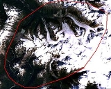
The Silverthrone Caldera is a potentially active caldera
complex in southwestern British Columbia
, Canada
, located over 350 kilometres (217.5 mi) northwest of the city of Vancouver
and about 50 kilometres (31.1 mi) west of Mount Waddington
in the Pacific Ranges
of the Coast Mountains
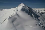
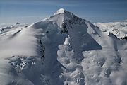
. The caldera is one of the largest of the few calderas in western Canada, measuring about 30 kilometres (18.6 mi) long (north-south) and 20 kilometres (12.4 mi) wide (east-west). Mount Silverthrone
, an eroded lava dome
on the caldera's northern flank that is 3160 metres (10,367.5 ft) high may be the highest volcano in Canada.
The main glacier
s in the Silverthrone area are the Pashleth
, Kingcome
, Trudel
, Klinaklini
and Silverthrone
glaciers. Most of the caldera lies in the Ha-Iltzuk Icefield
, which is the largest icefield in the southern half of the Coast Mountains; it is one of the five icefields in southwestern British Columbia that thinned between the mid-1980s and 1999 due to global warming
. Nearly half of the icefield is drained by the Klinaklini Glacier, which feeds the Klinaklini River
.
The Silverthrone Caldera is very remote and rarely visited or studied by geoscientists, such as volcanologists
. It can be reached by helicopter
or— with major difficulty— by hiking along one of the several river valleys extending from the British Columbia Coast
or from the Interior Plateau
.
, which is circumscribed by a group of epizonal intrusion
s. At another deeply eroded caldera complex called Franklin Glacier Volcano
, the Pemberton Volcanic Belt merges with the Garibaldi Volcanic Belt
, a northwest-trending belt of volcanic cones and fields extending from near the Canada–United States border east of Vancouver
on the British Columbia Coast
. The intrusions are thought to be subvolcanic
bodies associated with a volcanic front that was active in the Miocene
, during early stages of subduction
of the Juan de Fuca Plate
. With the notable exception of King Island
, all the intrusive and eruptive rocks are calc-alkaline, mainly granodioritic
bodies and dacite
ejecta.
On a broader scale, the intrusive and eruptive rocks are part of the Coast Plutonic Complex, which is the single largest contiguous granite
outcropping in North America. The intrusive and metamorphic rock
s extend approximately 1800 kilometres (1,118.5 mi) along the coast of British Columbia, the Alaska Panhandle
and southwestern Yukon
. This is a remnant of a once vast volcanic arc
called the Coast Range Arc that formed as a result of subduction of the Farallon
and Kula Plate
s during the Jurassic
-to-Eocene
periods. In contrast, Garibaldi
, Mount Meager
, Mount Cayley
and Silverthrone areas are of recent volcanic origin.
 Like other calderas, Silverthrone formed as a result of emptying the magma chamber
beneath the volcano. If enough magma
is erupted, the emptied chamber will not be able to support the weight of the volcanic edifice above it. A roughly circular fracture—a "ring fault"—develops around the edge of the chamber. These ring fractures serve as feeders for fault intrusions that are also known as ring dike
s. Secondary volcanic vents may form above the ring fracture. As the magma chamber empties, the center of the volcano within the ring fracture begins to collapse. The collapse may occur as the result of a single cataclysmic eruption, or it may occur in stages as the result of a series of eruptions. The total area that collapses may be hundreds of thousands of square kilometers.
Steep contacts between the thick basal breccia
of Mount Silverthrone and older crystalline rocks of adjacent peaks suggest that the breccia is part of a caldera-fill succession. The presence of irregular subvolcanic intrusions and a profusion of dike
s within the breccia—but not in adjacent country rock—provide further evidence of the Silverthrone Caldera. Potassium-argon dates
of 750,000 and 400,000 years on rhyolitic
lava dome
s above the basal breccia are consistent with the high rates of uplift and erosion
recorded elsewhere in the Coast Mountains.
 The still largely unexplained tectonic causes of the volcanism that has produced the Silverthrone Caldera are a matter of ongoing research. Silverthrone is not above a hotspot
as are Nazko
or Hawaii
. However, it may be a product of the Cascadia subduction zone
because andesite
, basalt
ic andesite, dacite
and rhyolite
can be found at the volcano and elsewhere along the subduction zone. At issue are the current plate configuration and rate of subduction
but Silverthrone's chemistry indicates that Silverthrone is subduction related.
The Cascadia subduction zone is a long convergent plate boundary that separates the Juan de Fuca
, Explorer
, Gorda
and North American Plate
s. Here, the oceanic crust
of the Pacific Ocean
sinks beneath North America
at a rate of 40 millimetres (1.6 in) per year. Hot magma upwelling above the descending oceanic plate creates volcanoes, each of which erupts for a few million years. It is estimated that the subduction zone has existed for at least 37 million years; in that time it has created a line of volcanoes, called the Cascade Volcanic Arc
, that stretches over 1000 kilometres (621.4 mi) along the subduction zone from Northern California
to Vancouver Island
. Several volcanoes in the arc are potentially active. All of the known historic eruptions in the arc have been in the United States
. Two of the most recent were Lassen Peak
in 1914 to 1921 and the major eruption of Mount St. Helens in 1980
. It is also the site of Canada's most recent major eruption, about 2,350 years ago at the Mount Meager
volcanic complex.
 Very little is known about Silverthrone’s eruptive history. However, as at other caldera
s, eruptions at Silverthrone are explosive in nature, involving viscous magma, glowing avalanches of hot volcanic ash
and pyroclastic flow
s. The source magma of this rock is classified as acid
ic, having high to intermediate levels of silica, as in rhyolite
, dacite
, and andesite
. Andesitic and rhyolitic magma are commonly associated with the two forms of explosive eruptions called Plinian
and Peléan eruption
s. Silverthrone is considerably younger than its nearest prominent neighbour Franklin Glacier Volcano
to the east-southeast.
Most of the caldera's eruptive products have been heavily eroded by alpine glaciers and are now exposed in precipitous slopes extending from near sea level to elevations less than 3000 metres (9,842.5 ft). The bulk of the complex appears to have been erupted between 100,000 and 500,000 years ago, but postglacial andesitic
and basaltic andesite
cones and lava flows are also present. Anomalously old Potassium-argon dates
of 1,000,000 and 1,100,000 years were obtained from a large lava flow at least 10 kilometres (6.2 mi) long in the postglacial Pashleth Creek and Machmell River
valleys. This blocky lava flow is clearly much younger than the potassium-argon date, and high-energy glacial streams have only begun to etch a channel along the margin of the lava flow. The younger andesitic rocks issued from a cluster of vents, now mostly ice-covered, ranged around the periphery of the caldera. At high elevations, proximal breccia
and cinder
s from several eroded cones rest on coarse colluvium derived from the older parts of the volcanic complex. The presence of unconsolidated glacial fluvial deposits under the flow suggest that it is less than 1,000 years old.
Although the particular Volcanic Explosivity Index
(VEI) of the Silverthrone Caldera is unknown, the chemistry and structure of the volcano can be compared to other calderas that have a history of producing some of the world's most violent eruptions. It is about 30 kilometres (18.6 mi) long and 20 kilometres (12.4 mi) wide while the Crater Lake
caldera in Oregon
, United States
is 10 kilometres (6 mi) long and 8 kilometres (5 mi) wide. Such calderas are usually formed by large cataclysmic eruptions reaching 7 on the Volcanic Explosivity Index (described as "super-colossal").
: the others are Castle Rock
, Mount Edziza
, Mount Cayley
, Hoodoo Mountain
, The Volcano
, Crow Lagoon
, Mount Garibaldi
, Mount Meager
, Wells Gray-Clearwater Volcanic Field
and Nazko Cone
. Seismic data suggests that these volcanoes still contain live magma plumbing systems, indicating possible future eruptive activity. Although the available data does not allow a clear conclusion, these observations are further indications that some of Canada's volcanoes are potentially active, and that their associated hazards may be significant. The seismic activity correlates both with some of Canada's most youthful volcanoes, and with long-lived volcanic centers with a history of significant explosive behavior, such as the Silverthrone Caldera.
 Volcanic eruptions in Canada rarely cause fatalities because of their remoteness and low level of activity. The only known fatality due to volcanic activity in Canada occurred at the Tseax Cone
in 1775, when a 22.5 kilometres (14 mi) long lava flow traveled down the Tseax
and Nass River
s, destroying a Nisga'a
village and killing approximately 2,000 people by volcanic gas
es. Towns and cities south of Silverthrone are home to well over half of British Columbia's human population, and there is a likelihood that future eruptions will cause damage to populated areas, making Silverthrone and other Garibaldi belt volcanoes further south a major potential hazard. For this reason, additional projects to study Silverthrone and other Garibaldi belt volcanoes to the south are being planned by the Geological Survey of Canada. There are significant hazards from almost all Canadian volcanoes that require hazard maps and emergency plans. Volcanoes which exhibit significant seismic activity, such as Silverthrone, appear to be most likely to erupt. A significant eruption of any of the Garibaldi belt volcanoes would significantly impact Highway 99 and communities like Pemberton
, Whistler
and Squamish
, and possibly Vancouver
.
can produce large amounts of ash that could significantly affect communities across Canada. Ash columns could rise to several hundred meters above the volcano which would make this a hazard for air traffic along the coastal airway
between Vancouver
and Alaska
. Volcanic ash reduces visibility and can cause jet engine failure as well as damage to other aircraft systems. In addition, pyroclastic fall
could also have a deleterious effect on the Ha-Iltzuk Icefield
surrounding the volcano. Melting of glacial ice could cause lahar
s or debris flow
s. This in turn could endanger water supplies on the Machmell River
and other local water sources.
, dacite
or rhyolite
) commonly move slowly and typically cover small areas to form steep-sided mounds called lava dome
s. Lava domes often grow by the extrusion of many individual flows less than 30 metres (98.4 ft) thick over a period of several months or years. Such flows will overlap one another and typically move less than a few meters per hour. But lava eruptions at Silverthrone Caldera can be more intense than those at other Cascade volcanoes. Lava flows with high to intermediate levels of silica rarely extend more than 8 kilometres (5 mi) from their source while Silverthrone has produced a 10 kilometres (6 mi) long andesitic lava flow in the Pashleth Creek and Machmell River valleys. There is also evidence lava flows may have once partly blocked or at least altered the course of the Machmell River. Renewed activity in this area could disrupt the course of the river and have a serious impact on people living or working downstream.
includes a variety of substances. These include gases trapped in cavities (vesicle
s) in volcanic rock
s, dissolved or dissociated gas
es in magma
and lava
, or gases emanating directly from lava or indirectly through ground water heated by volcanic action
. The volcanic gases that pose the greatest potential hazard to people, animals, agriculture, and property are sulfur dioxide
, carbon dioxide
and hydrogen fluoride
. Locally, sulfur dioxide gas can lead to acid rain
and air pollution downwind from the volcano. Globally, large explosive eruptions that inject a tremendous volume of sulfur aerosols into the stratosphere
can lead to lower surface temperatures and promote weakening of the Earth's ozone layer
. Because carbon dioxide gas is heavier than air, the gas may flow into in low-lying areas and collect in the soil. The concentration of carbon dioxide gas in these areas can be lethal to people, animals, and vegetation.
 Currently Silverthrone is not monitored closely enough by the Geological Survey of Canada to ascertain how active the volcano's magma system is. The existing network of seismograph
s has been established to monitor tectonic earthquakes and is too far away to provide a good indication of what is happening beneath the caldera. It may sense an increase in activity if the volcano becomes very restless, but this may only provide a warning for a large eruption. It might detect activity only after the volcano has started erupting.
A possible way to detect an eruption is studying Silverthrone's geological history since every volcano has its own pattern of behavior, in terms of its eruption style, magnitude and frequency, so that its future eruption is expected to be similar to its previous eruptions. But this would likely be abandoned in part because of the volcano's remoteness.
While there is a likelihood of Canada being critically effected by local or close by volcanic eruptions argues that some kind of improvement program is required. Benefit-cost thoughts are critical to dealing with natural hazards. However, a benefit-cost examination needs correct data about the hazard types, magnitudes and occurrences. These do not exist for volcanoes in British Columbia or elsewhere in Canada in the detail required.
Other volcanic techniques, such as hazard mapping, displays a volcano's eruptive history in detail and speculates an understanding of the hazardous activity that could possibly be expected in the future. At present no hazard maps have been created for the Silverthrone Caldera because the level of knowledge is insufficient due to its remoteness. A large volcanic hazard program has never existed within the Geological Survey of Canada. The majority of information has been collected in a lengthy, separate way from the support of several employees, such as volcanologist
s and other geologic scientist
s. Current knowledge is best established at Mount Meager
and is likely to rise considerably with a temporary mapping and monitoring project. Knowledge at the Silverthrone Caldera and other volcanoes in the Garibaldi Volcanic Belt is not as established, but certain contributions are being done at least Mount Cayley
. An intensive program classifiying infrastructural exposure near all young Canadian volcanoes and quick hazard assessments at each individual volcanic edifice associated with recent seismic activity would be in advance and would produce a quick and productive determination of priority areas for further efforts.
 The existing network of seismographs to monitor tectonic earthquakes has existed since 1975, although it remained small in population until 1985. Apart from a few short-term seismic monitoring experiments by the Geological Survey of Canada, no volcano monitoring has been accomplished at the Silverthrone Caldera or at other volcanoes in Canada at a level approaching that in other established countries with historically active volcanoes. Active or restless volcanoes are usually monitored using at least three seismographs all within approximately 15 kilometres (9.3 mi), and frequently within 5 kilometres (3 mi), for better sensitivity of detection and reduced location errors, particularly for earthquake depth. Such monitoring detects the risk of an eruption, offering a forecasting capability which is important to mitigating volcanic risk. Currently the Silverthrone Caldera does not have a seismograph closer than 124 kilometres (77.1 mi). With increasing distance and declining numbers of seismographs used to indicate seismic activity, the prediction capability is reduced because earthquake location and depth measurement accuracy decreases. The inaccurate earthquake locations in the Garibaldi Volcanic Belt are a few kilometers, and in more isolated northern regions they are up to 10 kilometres (6 mi). The location magnitude level in the Garibaldi Volcanic Belt is about magnitude 1 to 1.5, and elsewhere it is magnitude 1.5 to 2. At "carefully monitored volcanoes both the located and noticed events are recorded and surveyed immediately to improve the understanding of a future eruption. Undetected events are not recorded or surveyed in British Columbia immediately, nor in an easy-to-access process.
In countries like Canada it is possible that small precursor earthquake swarms might go undetected, particularly if no events were observed; more significant events in larger swarms would be detected but only a minor subdivision of the swarm events would be complex to clarify them with confidence as volcanic in nature, or even associate them with an individual volcanic edifice.
Caldera
A caldera is a cauldron-like volcanic feature usually formed by the collapse of land following a volcanic eruption, such as the one at Yellowstone National Park in the US. They are sometimes confused with volcanic craters...
complex in southwestern British Columbia
British Columbia
British Columbia is the westernmost of Canada's provinces and is known for its natural beauty, as reflected in its Latin motto, Splendor sine occasu . Its name was chosen by Queen Victoria in 1858...
, Canada
Canada
Canada is a North American country consisting of ten provinces and three territories. Located in the northern part of the continent, it extends from the Atlantic Ocean in the east to the Pacific Ocean in the west, and northward into the Arctic Ocean...
, located over 350 kilometres (217.5 mi) northwest of the city of Vancouver
Vancouver
Vancouver is a coastal seaport city on the mainland of British Columbia, Canada. It is the hub of Greater Vancouver, which, with over 2.3 million residents, is the third most populous metropolitan area in the country,...
and about 50 kilometres (31.1 mi) west of Mount Waddington
Mount Waddington
Mount Waddington, once known as Mystery Mountain, is the highest peak in the Coast Mountains of British Columbia, Canada. Although Mount Fairweather and Mount Quincy Adams, which straddle the US border between Alaska and British Columbia are taller, Mount Waddington is the highest peak that lies...
in the Pacific Ranges
Pacific Ranges
The Pacific Ranges are the southernmost subdivision of the Coast Mountains portion of the Pacific Cordillera. Located entirely within British Columbia, Canada, they run northwest from the lower stretches of the Fraser River to Bella Coola, north of which are the Kitimat Ranges.The Pacific Ranges...
of the Coast Mountains
Coast Mountains
The Coast Mountains are a major mountain range, in the Pacific Coast Ranges, of western North America, extending from southwestern Yukon through the Alaska Panhandle and virtually all of the Coast of British Columbia. They are so-named because of their proximity to the sea coast, and are often...
. The caldera is one of the largest of the few calderas in western Canada, measuring about 30 kilometres (18.6 mi) long (north-south) and 20 kilometres (12.4 mi) wide (east-west). Mount Silverthrone
Mount Silverthrone
Mount Silverthrone, officially named Silverthrone Mountain, is a mountain in the Regional District of Mount Waddington, British Columbia, located over northwest of the city of Vancouver and about west of Mount Waddington, British Columbia, Canada...
, an eroded lava dome
Lava dome
|250px|thumb|right|Image of the [[rhyolitic]] lava dome of [[Chaitén Volcano]] during its 2008–2009 eruption.In volcanology, a lava dome is a roughly circular mound-shaped protrusion resulting from the slow extrusion of viscous lava from a volcano...
on the caldera's northern flank that is 3160 metres (10,367.5 ft) high may be the highest volcano in Canada.
The main glacier
Glacier
A glacier is a large persistent body of ice that forms where the accumulation of snow exceeds its ablation over many years, often centuries. At least 0.1 km² in area and 50 m thick, but often much larger, a glacier slowly deforms and flows due to stresses induced by its weight...
s in the Silverthrone area are the Pashleth
Pashleth Glacier
The Pashleth Glacier is a glacier south of the Machmell River and west of the Klinaklini Glacier in southwestern British Columbia, Canada.-References:...
, Kingcome
Kingcome Glacier
The Kingcome Glacier is a glacier at the head of the Kingcome River in southwestern British Columbia, Canada.-References:...
, Trudel
Trudel Glacier
The Trudel Glacier is a glacier at the head of Trudel Creek in southwestern British Columbia, Canada....
, Klinaklini
Klinaklini Glacier
The Klinaklini Glacier is a glacier west of the Klinaklini River and head of Knight Inlet in southwestern British Columbia, Canada.-References:...
and Silverthrone
Silverthrone Glacier
The Silverthrone Glacier is a glacier at the northwest head of Knight Inlet in southwestern British Columbia, Canada.-References:...
glaciers. Most of the caldera lies in the Ha-Iltzuk Icefield
Ha-Iltzuk Icefield
The Ha-Iltzuk Icefield is an icefield in the central Pacific Ranges of the Coast Mountains in British Columbia, Canada. It is the largest icefield in the Coast Mountains south of the Alaska Panhandle, with an area of . It is located on the west side of the Klinaklini River and the Waddington Range...
, which is the largest icefield in the southern half of the Coast Mountains; it is one of the five icefields in southwestern British Columbia that thinned between the mid-1980s and 1999 due to global warming
Global warming
Global warming refers to the rising average temperature of Earth's atmosphere and oceans and its projected continuation. In the last 100 years, Earth's average surface temperature increased by about with about two thirds of the increase occurring over just the last three decades...
. Nearly half of the icefield is drained by the Klinaklini Glacier, which feeds the Klinaklini River
Klinaklini River
The Klinaklini River is one of the major rivers of the Pacific Ranges section of the Coast Mountains in British Columbia. It begins in the northern basins of the Pantheon Range to the north of Mount Waddington and briefly heads northeast onto the Chilcotin Plateau before bending around...
.
The Silverthrone Caldera is very remote and rarely visited or studied by geoscientists, such as volcanologists
Volcanology
Volcanology is the study of volcanoes, lava, magma, and related geological, geophysical and geochemical phenomena. The term volcanology is derived from the Latin word vulcan. Vulcan was the ancient Roman god of fire....
. It can be reached by helicopter
Helicopter
A helicopter is a type of rotorcraft in which lift and thrust are supplied by one or more engine-driven rotors. This allows the helicopter to take off and land vertically, to hover, and to fly forwards, backwards, and laterally...
or— with major difficulty— by hiking along one of the several river valleys extending from the British Columbia Coast
British Columbia Coast
The British Columbia Coast or BC Coast is Canada's western continental coastline on the Pacific Ocean. The usage is synonymous with the term West Coast of Canada....
or from the Interior Plateau
Interior Plateau
The Interior Plateau comprises a large region of central British Columbia, and lies between the Cariboo and Monashee Mountains on the east, and the Hazelton Mountains, Coast Mountains and Cascade Range on the west. The continuation of the plateau into the United States is known there as the...
.
Geology
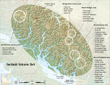
Silverthrone is part of the Pemberton Volcanic BeltPemberton Volcanic Belt
The Pemberton Volcanic Belt is an eroded Oligocene volcanic belt at a low angle near Mount Meager, British Columbia, Canada. The Garibaldi and Pemberton volcanic belts appear to merge into a single belt, although the Pemberton is older than the Garibaldi Volcanic Belt...
, which is circumscribed by a group of epizonal intrusion
Intrusion
An intrusion is liquid rock that forms under Earth's surface. Magma from under the surface is slowly pushed up from deep within the earth into any cracks or spaces it can find, sometimes pushing existing country rock out of the way, a process that can take millions of years. As the rock slowly...
s. At another deeply eroded caldera complex called Franklin Glacier Volcano
Franklin Glacier Volcano
Franklin Glacier Volcano is a deeply eroded and huge long and wide caldera complex in southwestern British Columbia, Canada, located east-southeast of the Silverthrone Caldera in the Hoodoo Creek and Franklin Glacier area on the northwest flank of the Waddington Massif of the Pacific Ranges...
, the Pemberton Volcanic Belt merges with the Garibaldi Volcanic Belt
Garibaldi Volcanic Belt
The Garibaldi Volcanic Belt, also called the Canadian Cascade Arc, is a northwest-southeast trending volcanic chain in the Pacific Ranges of the Coast Mountains that extends from Watts Point in the south to the Ha-Iltzuk Icefield in the north. This chain of volcanoes is located in southwestern...
, a northwest-trending belt of volcanic cones and fields extending from near the Canada–United States border east of Vancouver
Vancouver
Vancouver is a coastal seaport city on the mainland of British Columbia, Canada. It is the hub of Greater Vancouver, which, with over 2.3 million residents, is the third most populous metropolitan area in the country,...
on the British Columbia Coast
British Columbia Coast
The British Columbia Coast or BC Coast is Canada's western continental coastline on the Pacific Ocean. The usage is synonymous with the term West Coast of Canada....
. The intrusions are thought to be subvolcanic
Subvolcanic rock
A subvolcanic rock, also known as a hypabyssal rock, is an igneous rock that originates at medium to shallow depths within the crust and contain intermediate grain size and often porphyritic texture. They have textures between volcanic and plutonic rocks. Subvolcanic rocks include diabase and...
bodies associated with a volcanic front that was active in the Miocene
Miocene
The Miocene is a geological epoch of the Neogene Period and extends from about . The Miocene was named by Sir Charles Lyell. Its name comes from the Greek words and and means "less recent" because it has 18% fewer modern sea invertebrates than the Pliocene. The Miocene follows the Oligocene...
, during early stages of subduction
Subduction
In geology, subduction is the process that takes place at convergent boundaries by which one tectonic plate moves under another tectonic plate, sinking into the Earth's mantle, as the plates converge. These 3D regions of mantle downwellings are known as "Subduction Zones"...
of the Juan de Fuca Plate
Juan de Fuca Plate
The Juan de Fuca Plate, named after the explorer of the same name, is a tectonic plate, generated from the Juan de Fuca Ridge, and subducting under the northerly portion of the western side of the North American Plate at the Cascadia subduction zone...
. With the notable exception of King Island
King Island (British Columbia)
King Island is an island on the coast of the Canadian province of British Columbia. It is located south of Dean Channel and about east of Bella Bella.. A number of other islands separate King Island from the open sea of Queen Charlotte Sound....
, all the intrusive and eruptive rocks are calc-alkaline, mainly granodioritic
Granodiorite
Granodiorite is an intrusive igneous rock similar to granite, but containing more plagioclase than orthoclase-type feldspar. Officially, it is defined as a phaneritic igneous rock with greater than 20% quartz by volume where at least 65% of the feldspar is plagioclase. It usually contains abundant...
bodies and dacite
Dacite
Dacite is an igneous, volcanic rock. It has an aphanitic to porphyritic texture and is intermediate in composition between andesite and rhyolite. The relative proportions of feldspars and quartz in dacite, and in many other volcanic rocks, are illustrated in the QAPF diagram...
ejecta.
On a broader scale, the intrusive and eruptive rocks are part of the Coast Plutonic Complex, which is the single largest contiguous granite
Granite
Granite is a common and widely occurring type of intrusive, felsic, igneous rock. Granite usually has a medium- to coarse-grained texture. Occasionally some individual crystals are larger than the groundmass, in which case the texture is known as porphyritic. A granitic rock with a porphyritic...
outcropping in North America. The intrusive and metamorphic rock
Metamorphic rock
Metamorphic rock is the transformation of an existing rock type, the protolith, in a process called metamorphism, which means "change in form". The protolith is subjected to heat and pressure causing profound physical and/or chemical change...
s extend approximately 1800 kilometres (1,118.5 mi) along the coast of British Columbia, the Alaska Panhandle
Alaska Panhandle
Southeast Alaska, sometimes referred to as the Alaska Panhandle, is the southeastern portion of the U.S. state of Alaska, which lies west of the northern half of the Canadian province of British Columbia. The majority of Southeast Alaska's area is part of the Tongass National Forest, the United...
and southwestern Yukon
Yukon
Yukon is the westernmost and smallest of Canada's three federal territories. It was named after the Yukon River. The word Yukon means "Great River" in Gwich’in....
. This is a remnant of a once vast volcanic arc
Volcanic arc
A volcanic arc is a chain of volcanoes positioned in an arc shape as seen from above. Offshore volcanoes form islands, resulting in a volcanic island arc. Generally they result from the subduction of an oceanic tectonic plate under another tectonic plate, and often parallel an oceanic trench...
called the Coast Range Arc that formed as a result of subduction of the Farallon
Farallon Plate
The Farallon Plate was an ancient oceanic plate, which began subducting under the west coast of the North American Plate— then located in modern Utah— as Pangaea broke apart during the Jurassic Period...
and Kula Plate
Kula Plate
The Kula Plate is an oceanic tectonic plate under the northern Pacific Ocean south of the Near Islands segment of the Aleutian Islands. It is subducting under the North American Plate at the Aleutian Trench and is surrounded by the Pacific Plate...
s during the Jurassic
Jurassic
The Jurassic is a geologic period and system that extends from about Mya to Mya, that is, from the end of the Triassic to the beginning of the Cretaceous. The Jurassic constitutes the middle period of the Mesozoic era, also known as the age of reptiles. The start of the period is marked by...
-to-Eocene
Eocene
The Eocene Epoch, lasting from about 56 to 34 million years ago , is a major division of the geologic timescale and the second epoch of the Paleogene Period in the Cenozoic Era. The Eocene spans the time from the end of the Palaeocene Epoch to the beginning of the Oligocene Epoch. The start of the...
periods. In contrast, Garibaldi
Mount Garibaldi
Mount Garibaldi is a potentially active stratovolcano in the Sea to Sky Country of British Columbia, north of Vancouver, Canada. Located in the southernmost Coast Mountains, it is one of the most recognized peaks in the South Coast region, as well as British Columbia's best known volcano...
, Mount Meager
Mount Meager
Mount Meager, originally known as Meager Mountain, is a complex volcano in the Sea-to-Sky Corridor of southwestern British Columbia, Canada. It is located north of Vancouver at the northern end of the Pemberton Valley. Part of the Cascade Volcanic Arc of western North America, its summit is above...
, Mount Cayley
Mount Cayley
Mount Cayley is a potentially active stratovolcano in Squamish-Lillooet Regional District of southwestern British Columbia, Canada. Located north of Squamish and west of Whistler in the Pacific Ranges of the Coast Mountains, it rises above the Squamish River to the west and above the Cheakamus...
and Silverthrone areas are of recent volcanic origin.
Structure
Magma chamber
A magma chamber is a large underground pool of molten rock found beneath the surface of the Earth. The molten rock in such a chamber is under great pressure, and given enough time, that pressure can gradually fracture the rock around it creating outlets for the magma...
beneath the volcano. If enough magma
Magma
Magma is a mixture of molten rock, volatiles and solids that is found beneath the surface of the Earth, and is expected to exist on other terrestrial planets. Besides molten rock, magma may also contain suspended crystals and dissolved gas and sometimes also gas bubbles. Magma often collects in...
is erupted, the emptied chamber will not be able to support the weight of the volcanic edifice above it. A roughly circular fracture—a "ring fault"—develops around the edge of the chamber. These ring fractures serve as feeders for fault intrusions that are also known as ring dike
Ring dike
A ring dike or ring dyke in geology refers to an intrusive igneous body. Their chemistry, petrology and field appearance precisely match those of dikes or sill, but their concentric or radial geometric distribution around a centre of volcanic activity indicates their subvolcanic origins.-Notable...
s. Secondary volcanic vents may form above the ring fracture. As the magma chamber empties, the center of the volcano within the ring fracture begins to collapse. The collapse may occur as the result of a single cataclysmic eruption, or it may occur in stages as the result of a series of eruptions. The total area that collapses may be hundreds of thousands of square kilometers.
Steep contacts between the thick basal breccia
Breccia
Breccia is a rock composed of broken fragments of minerals or rock cemented together by a fine-grained matrix, that can be either similar to or different from the composition of the fragments....
of Mount Silverthrone and older crystalline rocks of adjacent peaks suggest that the breccia is part of a caldera-fill succession. The presence of irregular subvolcanic intrusions and a profusion of dike
Dike (geology)
A dike or dyke in geology is a type of sheet intrusion referring to any geologic body that cuts discordantly across* planar wall rock structures, such as bedding or foliation...
s within the breccia—but not in adjacent country rock—provide further evidence of the Silverthrone Caldera. Potassium-argon dates
Potassium-argon dating
Potassium–argon dating or K–Ar dating is a radiometric dating method used in geochronology and archeology. It is based on measurement of the product of the radioactive decay of an isotope of potassium into argon . Potassium is a common element found in many materials, such as micas, clay minerals,...
of 750,000 and 400,000 years on rhyolitic
Rhyolite
This page is about a volcanic rock. For the ghost town see Rhyolite, Nevada, and for the satellite system, see Rhyolite/Aquacade.Rhyolite is an igneous, volcanic rock, of felsic composition . It may have any texture from glassy to aphanitic to porphyritic...
lava dome
Lava dome
|250px|thumb|right|Image of the [[rhyolitic]] lava dome of [[Chaitén Volcano]] during its 2008–2009 eruption.In volcanology, a lava dome is a roughly circular mound-shaped protrusion resulting from the slow extrusion of viscous lava from a volcano...
s above the basal breccia are consistent with the high rates of uplift and erosion
Erosion
Erosion is when materials are removed from the surface and changed into something else. It only works by hydraulic actions and transport of solids in the natural environment, and leads to the deposition of these materials elsewhere...
recorded elsewhere in the Coast Mountains.
Origins
Hotspot (geology)
The places known as hotspots or hot spots in geology are volcanic regions thought to be fed by underlying mantle that is anomalously hot compared with the mantle elsewhere. They may be on, near to, or far from tectonic plate boundaries. There are two hypotheses to explain them...
as are Nazko
Nazko Cone
Nazko Cone is a small potentially active basaltic cinder cone in central British Columbia, Canada, located 75 km west of Quesnel and 150 kilometers southwest of Prince George. It is considered the easternmost volcano in the Anahim Volcanic Belt. The small tree-covered cone rises 120 m above...
or Hawaii
Hawaii
Hawaii is the newest of the 50 U.S. states , and is the only U.S. state made up entirely of islands. It is the northernmost island group in Polynesia, occupying most of an archipelago in the central Pacific Ocean, southwest of the continental United States, southeast of Japan, and northeast of...
. However, it may be a product of the Cascadia subduction zone
Cascadia subduction zone
The Cascadia subduction zone is a subduction zone, a type of convergent plate boundary that stretches from northern Vancouver Island to northern California. It is a very long sloping fault that separates the Juan de Fuca and North America plates.New ocean floor is being created offshore of...
because andesite
Andesite
Andesite is an extrusive igneous, volcanic rock, of intermediate composition, with aphanitic to porphyritic texture. In a general sense, it is the intermediate type between basalt and dacite. The mineral assemblage is typically dominated by plagioclase plus pyroxene and/or hornblende. Magnetite,...
, basalt
Basalt
Basalt is a common extrusive volcanic rock. It is usually grey to black and fine-grained due to rapid cooling of lava at the surface of a planet. It may be porphyritic containing larger crystals in a fine matrix, or vesicular, or frothy scoria. Unweathered basalt is black or grey...
ic andesite, dacite
Dacite
Dacite is an igneous, volcanic rock. It has an aphanitic to porphyritic texture and is intermediate in composition between andesite and rhyolite. The relative proportions of feldspars and quartz in dacite, and in many other volcanic rocks, are illustrated in the QAPF diagram...
and rhyolite
Rhyolite
This page is about a volcanic rock. For the ghost town see Rhyolite, Nevada, and for the satellite system, see Rhyolite/Aquacade.Rhyolite is an igneous, volcanic rock, of felsic composition . It may have any texture from glassy to aphanitic to porphyritic...
can be found at the volcano and elsewhere along the subduction zone. At issue are the current plate configuration and rate of subduction
Subduction
In geology, subduction is the process that takes place at convergent boundaries by which one tectonic plate moves under another tectonic plate, sinking into the Earth's mantle, as the plates converge. These 3D regions of mantle downwellings are known as "Subduction Zones"...
but Silverthrone's chemistry indicates that Silverthrone is subduction related.
The Cascadia subduction zone is a long convergent plate boundary that separates the Juan de Fuca
Juan de Fuca Plate
The Juan de Fuca Plate, named after the explorer of the same name, is a tectonic plate, generated from the Juan de Fuca Ridge, and subducting under the northerly portion of the western side of the North American Plate at the Cascadia subduction zone...
, Explorer
Explorer Plate
The Explorer Plate is an oceanic tectonic plate beneath the Pacific Ocean off the west coast of Vancouver Island, Canada.The eastern boundary of the Explorer Plate is being slowly subducted under the North American Plate, to which it may eventually accrete owing to the slow rate of subduction...
, Gorda
Gorda Plate
The Gorda Plate, located beneath the Pacific Ocean off the coast of northern California, is one of the northern remnants of the Farallon Plate. It is sometimes referred to as simply the southernmost portion of the neighboring Juan de Fuca Plate, another Farallon remnant.Unlike most tectonic...
and North American Plate
North American Plate
The North American Plate is a tectonic plate covering most of North America, Greenland, Cuba, Bahamas, and parts of Siberia, Japan and Iceland. It extends eastward to the Mid-Atlantic Ridge and westward to the Chersky Range in eastern Siberia. The plate includes both continental and oceanic crust...
s. Here, the oceanic crust
Oceanic crust
Oceanic crust is the part of Earth's lithosphere that surfaces in the ocean basins. Oceanic crust is primarily composed of mafic rocks, or sima, which is rich in iron and magnesium...
of the Pacific Ocean
Pacific Ocean
The Pacific Ocean is the largest of the Earth's oceanic divisions. It extends from the Arctic in the north to the Southern Ocean in the south, bounded by Asia and Australia in the west, and the Americas in the east.At 165.2 million square kilometres in area, this largest division of the World...
sinks beneath North America
North America
North America is a continent wholly within the Northern Hemisphere and almost wholly within the Western Hemisphere. It is also considered a northern subcontinent of the Americas...
at a rate of 40 millimetres (1.6 in) per year. Hot magma upwelling above the descending oceanic plate creates volcanoes, each of which erupts for a few million years. It is estimated that the subduction zone has existed for at least 37 million years; in that time it has created a line of volcanoes, called the Cascade Volcanic Arc
Cascade Volcanoes
The Cascade Volcanoes are a number of volcanoes in a volcanic arc in western North America, extending from southwestern British Columbia through Washington and Oregon to Northern California, a distance of well over 700 mi ...
, that stretches over 1000 kilometres (621.4 mi) along the subduction zone from Northern California
Northern California
Northern California is the northern portion of the U.S. state of California. The San Francisco Bay Area , and Sacramento as well as its metropolitan area are the main population centers...
to Vancouver Island
Vancouver Island
Vancouver Island is a large island in British Columbia, Canada. It is one of several North American locations named after George Vancouver, the British Royal Navy officer who explored the Pacific Northwest coast of North America between 1791 and 1794...
. Several volcanoes in the arc are potentially active. All of the known historic eruptions in the arc have been in the United States
United States
The United States of America is a federal constitutional republic comprising fifty states and a federal district...
. Two of the most recent were Lassen Peak
Lassen Peak
Lassen Peak is the southernmost active volcano in the Cascade Range. It is part of the Cascade Volcanic Arc which is an arc that stretches from northern California to southwestern British Columbia...
in 1914 to 1921 and the major eruption of Mount St. Helens in 1980
1980 eruption of Mount St. Helens
The 1980 eruption of Mount St. Helens, a stratovolcano located in Washington state, in the United States, was a major volcanic eruption. The eruption was the only significant one to occur in the contiguous 48 U.S. states since the 1915 eruption of Lassen Peak in California...
. It is also the site of Canada's most recent major eruption, about 2,350 years ago at the Mount Meager
Mount Meager
Mount Meager, originally known as Meager Mountain, is a complex volcano in the Sea-to-Sky Corridor of southwestern British Columbia, Canada. It is located north of Vancouver at the northern end of the Pemberton Valley. Part of the Cascade Volcanic Arc of western North America, its summit is above...
volcanic complex.
Eruptive history
Caldera
A caldera is a cauldron-like volcanic feature usually formed by the collapse of land following a volcanic eruption, such as the one at Yellowstone National Park in the US. They are sometimes confused with volcanic craters...
s, eruptions at Silverthrone are explosive in nature, involving viscous magma, glowing avalanches of hot volcanic ash
Volcanic ash
Volcanic ash consists of small tephra, which are bits of pulverized rock and glass created by volcanic eruptions, less than in diameter. There are three mechanisms of volcanic ash formation: gas release under decompression causing magmatic eruptions; thermal contraction from chilling on contact...
and pyroclastic flow
Pyroclastic flow
A pyroclastic flow is a fast-moving current of superheated gas and rock , which reaches speeds moving away from a volcano of up to 700 km/h . The flows normally hug the ground and travel downhill, or spread laterally under gravity...
s. The source magma of this rock is classified as acid
Acid
An acid is a substance which reacts with a base. Commonly, acids can be identified as tasting sour, reacting with metals such as calcium, and bases like sodium carbonate. Aqueous acids have a pH of less than 7, where an acid of lower pH is typically stronger, and turn blue litmus paper red...
ic, having high to intermediate levels of silica, as in rhyolite
Rhyolite
This page is about a volcanic rock. For the ghost town see Rhyolite, Nevada, and for the satellite system, see Rhyolite/Aquacade.Rhyolite is an igneous, volcanic rock, of felsic composition . It may have any texture from glassy to aphanitic to porphyritic...
, dacite
Dacite
Dacite is an igneous, volcanic rock. It has an aphanitic to porphyritic texture and is intermediate in composition between andesite and rhyolite. The relative proportions of feldspars and quartz in dacite, and in many other volcanic rocks, are illustrated in the QAPF diagram...
, and andesite
Andesite
Andesite is an extrusive igneous, volcanic rock, of intermediate composition, with aphanitic to porphyritic texture. In a general sense, it is the intermediate type between basalt and dacite. The mineral assemblage is typically dominated by plagioclase plus pyroxene and/or hornblende. Magnetite,...
. Andesitic and rhyolitic magma are commonly associated with the two forms of explosive eruptions called Plinian
Plinian eruption
Plinian eruptions, also known as 'Vesuvian eruptions', are volcanic eruptions marked by their similarity to the eruption of Mount Vesuvius in AD 79 ....
and Peléan eruption
Pelean eruption
Peléan eruptions are a type of volcanic eruption. They can occur when viscous magma, typically of rhyolitic or andesitic type, is involved, and share some similarities with Vulcanian eruptions. The most important characteristics of a Peléan eruption is the presence of a glowing avalanche of hot...
s. Silverthrone is considerably younger than its nearest prominent neighbour Franklin Glacier Volcano
Franklin Glacier Volcano
Franklin Glacier Volcano is a deeply eroded and huge long and wide caldera complex in southwestern British Columbia, Canada, located east-southeast of the Silverthrone Caldera in the Hoodoo Creek and Franklin Glacier area on the northwest flank of the Waddington Massif of the Pacific Ranges...
to the east-southeast.
Most of the caldera's eruptive products have been heavily eroded by alpine glaciers and are now exposed in precipitous slopes extending from near sea level to elevations less than 3000 metres (9,842.5 ft). The bulk of the complex appears to have been erupted between 100,000 and 500,000 years ago, but postglacial andesitic
Andesite
Andesite is an extrusive igneous, volcanic rock, of intermediate composition, with aphanitic to porphyritic texture. In a general sense, it is the intermediate type between basalt and dacite. The mineral assemblage is typically dominated by plagioclase plus pyroxene and/or hornblende. Magnetite,...
and basaltic andesite
Basaltic andesite
Basaltic andesite is a black volcanic rock containing about 55% silica. Minerals in basaltic andesite include olivine, augite and plagioclase. Basaltic andesite can be found in volcanoes around the world, including in Central America and the Andes of South America. Basaltic andesite is common in...
cones and lava flows are also present. Anomalously old Potassium-argon dates
Potassium-argon dating
Potassium–argon dating or K–Ar dating is a radiometric dating method used in geochronology and archeology. It is based on measurement of the product of the radioactive decay of an isotope of potassium into argon . Potassium is a common element found in many materials, such as micas, clay minerals,...
of 1,000,000 and 1,100,000 years were obtained from a large lava flow at least 10 kilometres (6.2 mi) long in the postglacial Pashleth Creek and Machmell River
Machmell River
The Machmell River, also spelled Machmel River, is a river in the Pacific Ranges of the southern Coast Mountains in British Columbia, Canada. It flows west into Owikeno Lake....
valleys. This blocky lava flow is clearly much younger than the potassium-argon date, and high-energy glacial streams have only begun to etch a channel along the margin of the lava flow. The younger andesitic rocks issued from a cluster of vents, now mostly ice-covered, ranged around the periphery of the caldera. At high elevations, proximal breccia
Breccia
Breccia is a rock composed of broken fragments of minerals or rock cemented together by a fine-grained matrix, that can be either similar to or different from the composition of the fragments....
and cinder
Cinder
A cinder is a pyroclastic material. Cinders are extrusive igneous rocks. Cinders are similar to pumice, which has so many cavities and is such low-density that it can float on water...
s from several eroded cones rest on coarse colluvium derived from the older parts of the volcanic complex. The presence of unconsolidated glacial fluvial deposits under the flow suggest that it is less than 1,000 years old.
Although the particular Volcanic Explosivity Index
Volcanic Explosivity Index
The Volcanic Explosivity Index was devised by Chris Newhall of the U.S. Geological Survey and Stephen Self at the University of Hawaii in 1982 to provide a relative measure of the explosiveness of volcanic eruptions....
(VEI) of the Silverthrone Caldera is unknown, the chemistry and structure of the volcano can be compared to other calderas that have a history of producing some of the world's most violent eruptions. It is about 30 kilometres (18.6 mi) long and 20 kilometres (12.4 mi) wide while the Crater Lake
Crater Lake
Crater Lake is a caldera lake located in the south-central region of the U.S. state of Oregon. It is the main feature of Crater Lake National Park and famous for its deep blue color and water clarity. The lake partly fills a nearly deep caldera that was formed around 7,700 years agoby the...
caldera in Oregon
Oregon
Oregon is a state in the Pacific Northwest region of the United States. It is located on the Pacific coast, with Washington to the north, California to the south, Nevada on the southeast and Idaho to the east. The Columbia and Snake rivers delineate much of Oregon's northern and eastern...
, United States
United States
The United States of America is a federal constitutional republic comprising fifty states and a federal district...
is 10 kilometres (6 mi) long and 8 kilometres (5 mi) wide. Such calderas are usually formed by large cataclysmic eruptions reaching 7 on the Volcanic Explosivity Index (described as "super-colossal").
Current activity
Silverthrone Caldera is one of the eleven Canadian volcanoes associated with recent seismic activitySeismology
Seismology is the scientific study of earthquakes and the propagation of elastic waves through the Earth or through other planet-like bodies. The field also includes studies of earthquake effects, such as tsunamis as well as diverse seismic sources such as volcanic, tectonic, oceanic,...
: the others are Castle Rock
Castle Rock (volcano)
Castle Rock is a volcanic neck located west of Iskut and 8 km northwest of Tuktsayda Mountain in British Columbia, Canada. It is part of the Pacific Ring of Fire that includes over 160 active volcanoes and is in the Klastline Group, Northern Cordilleran Volcanic Province and last erupted in...
, Mount Edziza
Mount Edziza
Mount Edziza is a stratovolcano in the Stikine Country of northwestern British Columbia, Canada. The volcano and the surrounding area are protected within Mount Edziza Provincial Park. It consists of a complex of multiple peaks and ridges, with several glaciers flowing in all directions. The summit...
, Mount Cayley
Mount Cayley
Mount Cayley is a potentially active stratovolcano in Squamish-Lillooet Regional District of southwestern British Columbia, Canada. Located north of Squamish and west of Whistler in the Pacific Ranges of the Coast Mountains, it rises above the Squamish River to the west and above the Cheakamus...
, Hoodoo Mountain
Hoodoo Mountain
Hoodoo Mountain is a potentially active flat-topped stratovolcano in the Stikine Country of northwestern British Columbia, Canada, located northeast of Wrangell, Alaska on the north side of the lower Iskut River and east of its junction with the Stikine River...
, The Volcano
The Volcano (British Columbia)
The Volcano, also known as Lava Fork volcano, is a small cinder cone in the Boundary Ranges of the Coast Mountains in northwestern British Columbia, Canada. It is located approximately northwest of the small community of Stewart near the head of Lava Fork...
, Crow Lagoon
Crow Lagoon
Crow Lagoon is a little-known volcanic center located north of Prince Rupert, British Columbia, Canada. There are beds of thick, basaltic tephra that are of Holocene age....
, Mount Garibaldi
Mount Garibaldi
Mount Garibaldi is a potentially active stratovolcano in the Sea to Sky Country of British Columbia, north of Vancouver, Canada. Located in the southernmost Coast Mountains, it is one of the most recognized peaks in the South Coast region, as well as British Columbia's best known volcano...
, Mount Meager
Mount Meager
Mount Meager, originally known as Meager Mountain, is a complex volcano in the Sea-to-Sky Corridor of southwestern British Columbia, Canada. It is located north of Vancouver at the northern end of the Pemberton Valley. Part of the Cascade Volcanic Arc of western North America, its summit is above...
, Wells Gray-Clearwater Volcanic Field
Wells Gray-Clearwater volcanic field
The Wells Gray-Clearwater volcanic field, also called the Clearwater Cone Group, is a potentially active monogenetic volcanic field in east-central British Columbia, Canada, located approximately north of Kamloops. It is situated in the Cariboo Mountains of the Columbia Mountains and on the...
and Nazko Cone
Nazko Cone
Nazko Cone is a small potentially active basaltic cinder cone in central British Columbia, Canada, located 75 km west of Quesnel and 150 kilometers southwest of Prince George. It is considered the easternmost volcano in the Anahim Volcanic Belt. The small tree-covered cone rises 120 m above...
. Seismic data suggests that these volcanoes still contain live magma plumbing systems, indicating possible future eruptive activity. Although the available data does not allow a clear conclusion, these observations are further indications that some of Canada's volcanoes are potentially active, and that their associated hazards may be significant. The seismic activity correlates both with some of Canada's most youthful volcanoes, and with long-lived volcanic centers with a history of significant explosive behavior, such as the Silverthrone Caldera.
Volcanic hazards
Tseax Cone
The Tseax Cone , also called the Tseax River Cone or alternately the Aiyansh Volcano, is a young cinder cone and adjacent lava flows associated with the Nass Ranges and the Northern Cordilleran Volcanic Province...
in 1775, when a 22.5 kilometres (14 mi) long lava flow traveled down the Tseax
Tseax River
The Tseax River, also known as Ksi Sii Aks in the Nisga'a language, is a tributary of the Nass River in northwestern British Columbia, Canada. It is most notable as the namesake of Tseax Cone, a volcano within its basin that was responsible for an eruption that killed 2,000 Nisga'a people. Prior...
and Nass River
Nass River
The Nass River is a river in northern British Columbia, Canada. It flows from the Coast Mountains southwest to Nass Bay, a sidewater of Portland Inlet, which connects to the North Pacific Ocean via the Dixon Entrance...
s, destroying a Nisga'a
Nisga'a
The Nisga’a , often formerly spelled Nishga and spelled in the Nisga’a language as Nisga’a, are an Indigenous nation or First Nation in Canada. They live in the Nass River valley of northwestern British Columbia. Their name comes from a combination of two Nisga’a words: Nisk’-"top lip" and...
village and killing approximately 2,000 people by volcanic gas
Volcanic gas
|250px|thumb|right|Image of the [[rhyolitic]] [[lava dome]] of [[Chaitén Volcano]] during its 2008-2010 eruption.Volcanic gases include a variety of substances given off by active volcanoes...
es. Towns and cities south of Silverthrone are home to well over half of British Columbia's human population, and there is a likelihood that future eruptions will cause damage to populated areas, making Silverthrone and other Garibaldi belt volcanoes further south a major potential hazard. For this reason, additional projects to study Silverthrone and other Garibaldi belt volcanoes to the south are being planned by the Geological Survey of Canada. There are significant hazards from almost all Canadian volcanoes that require hazard maps and emergency plans. Volcanoes which exhibit significant seismic activity, such as Silverthrone, appear to be most likely to erupt. A significant eruption of any of the Garibaldi belt volcanoes would significantly impact Highway 99 and communities like Pemberton
Pemberton, British Columbia
Pemberton is a village north of Whistler in the Pemberton Valley of British Columbia in Canada, with a population of 2,192. Until the 1960s the village could be accessed only by train but that changed when Highway 99 was built through Whistler and Pemberton.-Climate:The climate of Pemberton is...
, Whistler
Whistler, British Columbia
Whistler is a Canadian resort town in the southern Pacific Ranges of the Coast Mountains in the province of British Columbia, Canada, approximately north of Vancouver...
and Squamish
Squamish, British Columbia
Squamish is a community and a district municipality in the Canadian province of British Columbia, located at the north end of Howe Sound on the Sea to Sky Highway...
, and possibly Vancouver
Vancouver
Vancouver is a coastal seaport city on the mainland of British Columbia, Canada. It is the hub of Greater Vancouver, which, with over 2.3 million residents, is the third most populous metropolitan area in the country,...
.
Explosive eruptions
The explosive nature of past eruptions at Silverthrone Caldera suggests that this volcano poses a significant long-distance threat to communities across Canada. A large explosive eruptionExplosive eruption
An explosive eruption is a volcanic term to describe a violent, explosive type of eruption. Mount St. Helens in 1980 was an example. Such an eruption is driven by gas accumulating under great pressure. Driven by hot rising magma, it interacts with ground water until the pressure increases to the...
can produce large amounts of ash that could significantly affect communities across Canada. Ash columns could rise to several hundred meters above the volcano which would make this a hazard for air traffic along the coastal airway
Airway
The pulmonary airway comprises those parts of the respiratory system through which air flows, conceptually beginning at the nose and mouth, and terminating in the alveoli...
between Vancouver
Vancouver
Vancouver is a coastal seaport city on the mainland of British Columbia, Canada. It is the hub of Greater Vancouver, which, with over 2.3 million residents, is the third most populous metropolitan area in the country,...
and Alaska
Alaska
Alaska is the largest state in the United States by area. It is situated in the northwest extremity of the North American continent, with Canada to the east, the Arctic Ocean to the north, and the Pacific Ocean to the west and south, with Russia further west across the Bering Strait...
. Volcanic ash reduces visibility and can cause jet engine failure as well as damage to other aircraft systems. In addition, pyroclastic fall
Pyroclastic fall
A pyroclastic fall is a uniform deposit of material which has been ejected from a volcanic eruption or plume such as an ash fall or tuff. Pyroclastic air fall deposits are a result of:...
could also have a deleterious effect on the Ha-Iltzuk Icefield
Ha-Iltzuk Icefield
The Ha-Iltzuk Icefield is an icefield in the central Pacific Ranges of the Coast Mountains in British Columbia, Canada. It is the largest icefield in the Coast Mountains south of the Alaska Panhandle, with an area of . It is located on the west side of the Klinaklini River and the Waddington Range...
surrounding the volcano. Melting of glacial ice could cause lahar
Lahar
A lahar is a type of mudflow or debris flow composed of a slurry of pyroclastic material, rocky debris, and water. The material flows down from a volcano, typically along a river valley. The term is a shortened version of "berlahar" which originated in the Javanese language of...
s or debris flow
Debris flow
A debris flow is a fast moving, liquefied landslide of unconsolidated, saturated debris that looks like flowing concrete. It is differentiated from a mudflow in terms of the viscosity and textural properties of the flow. Flows can carry material ranging in size from clay to boulders, and may...
s. This in turn could endanger water supplies on the Machmell River
Machmell River
The Machmell River, also spelled Machmel River, is a river in the Pacific Ranges of the southern Coast Mountains in British Columbia, Canada. It flows west into Owikeno Lake....
and other local water sources.
Lava flows
Because the Silverthrone region is in a remote and exceptionally rugged part of the Coast Mountains, danger from lava flows would be low to moderate. Magma with high to intermediate levels of silica (as in andesiteAndesite
Andesite is an extrusive igneous, volcanic rock, of intermediate composition, with aphanitic to porphyritic texture. In a general sense, it is the intermediate type between basalt and dacite. The mineral assemblage is typically dominated by plagioclase plus pyroxene and/or hornblende. Magnetite,...
, dacite
Dacite
Dacite is an igneous, volcanic rock. It has an aphanitic to porphyritic texture and is intermediate in composition between andesite and rhyolite. The relative proportions of feldspars and quartz in dacite, and in many other volcanic rocks, are illustrated in the QAPF diagram...
or rhyolite
Rhyolite
This page is about a volcanic rock. For the ghost town see Rhyolite, Nevada, and for the satellite system, see Rhyolite/Aquacade.Rhyolite is an igneous, volcanic rock, of felsic composition . It may have any texture from glassy to aphanitic to porphyritic...
) commonly move slowly and typically cover small areas to form steep-sided mounds called lava dome
Lava dome
|250px|thumb|right|Image of the [[rhyolitic]] lava dome of [[Chaitén Volcano]] during its 2008–2009 eruption.In volcanology, a lava dome is a roughly circular mound-shaped protrusion resulting from the slow extrusion of viscous lava from a volcano...
s. Lava domes often grow by the extrusion of many individual flows less than 30 metres (98.4 ft) thick over a period of several months or years. Such flows will overlap one another and typically move less than a few meters per hour. But lava eruptions at Silverthrone Caldera can be more intense than those at other Cascade volcanoes. Lava flows with high to intermediate levels of silica rarely extend more than 8 kilometres (5 mi) from their source while Silverthrone has produced a 10 kilometres (6 mi) long andesitic lava flow in the Pashleth Creek and Machmell River valleys. There is also evidence lava flows may have once partly blocked or at least altered the course of the Machmell River. Renewed activity in this area could disrupt the course of the river and have a serious impact on people living or working downstream.
Volcanic gas
Volcanic gasVolcanic gas
|250px|thumb|right|Image of the [[rhyolitic]] [[lava dome]] of [[Chaitén Volcano]] during its 2008-2010 eruption.Volcanic gases include a variety of substances given off by active volcanoes...
includes a variety of substances. These include gases trapped in cavities (vesicle
Vesicular texture
Vesicular texture is a volcanic rock texture characterised by a rock being pitted with many cavities at its surface and inside. The texture is often found in extrusive aphanitic, or glassy, igneous rock...
s) in volcanic rock
Volcanic rock
Volcanic rock is a rock formed from magma erupted from a volcano. In other words, it is an igneous rock of volcanic origin...
s, dissolved or dissociated gas
Gas
Gas is one of the three classical states of matter . Near absolute zero, a substance exists as a solid. As heat is added to this substance it melts into a liquid at its melting point , boils into a gas at its boiling point, and if heated high enough would enter a plasma state in which the electrons...
es in magma
Magma
Magma is a mixture of molten rock, volatiles and solids that is found beneath the surface of the Earth, and is expected to exist on other terrestrial planets. Besides molten rock, magma may also contain suspended crystals and dissolved gas and sometimes also gas bubbles. Magma often collects in...
and lava
Lava
Lava refers both to molten rock expelled by a volcano during an eruption and the resulting rock after solidification and cooling. This molten rock is formed in the interior of some planets, including Earth, and some of their satellites. When first erupted from a volcanic vent, lava is a liquid at...
, or gases emanating directly from lava or indirectly through ground water heated by volcanic action
Hydrothermal circulation
Hydrothermal circulation in its most general sense is the circulation of hot water; 'hydros' in the Greek meaning water and 'thermos' meaning heat. Hydrothermal circulation occurs most often in the vicinity of sources of heat within the Earth's crust...
. The volcanic gases that pose the greatest potential hazard to people, animals, agriculture, and property are sulfur dioxide
Sulfur dioxide
Sulfur dioxide is the chemical compound with the formula . It is released by volcanoes and in various industrial processes. Since coal and petroleum often contain sulfur compounds, their combustion generates sulfur dioxide unless the sulfur compounds are removed before burning the fuel...
, carbon dioxide
Carbon dioxide
Carbon dioxide is a naturally occurring chemical compound composed of two oxygen atoms covalently bonded to a single carbon atom...
and hydrogen fluoride
Hydrogen fluoride
Hydrogen fluoride is a chemical compound with the formula HF. This colorless gas is the principal industrial source of fluorine, often in the aqueous form as hydrofluoric acid, and thus is the precursor to many important compounds including pharmaceuticals and polymers . HF is widely used in the...
. Locally, sulfur dioxide gas can lead to acid rain
Acid rain
Acid rain is a rain or any other form of precipitation that is unusually acidic, meaning that it possesses elevated levels of hydrogen ions . It can have harmful effects on plants, aquatic animals, and infrastructure. Acid rain is caused by emissions of carbon dioxide, sulfur dioxide and nitrogen...
and air pollution downwind from the volcano. Globally, large explosive eruptions that inject a tremendous volume of sulfur aerosols into the stratosphere
Stratosphere
The stratosphere is the second major layer of Earth's atmosphere, just above the troposphere, and below the mesosphere. It is stratified in temperature, with warmer layers higher up and cooler layers farther down. This is in contrast to the troposphere near the Earth's surface, which is cooler...
can lead to lower surface temperatures and promote weakening of the Earth's ozone layer
Ozone layer
The ozone layer is a layer in Earth's atmosphere which contains relatively high concentrations of ozone . This layer absorbs 97–99% of the Sun's high frequency ultraviolet light, which is potentially damaging to the life forms on Earth...
. Because carbon dioxide gas is heavier than air, the gas may flow into in low-lying areas and collect in the soil. The concentration of carbon dioxide gas in these areas can be lethal to people, animals, and vegetation.
Monitoring
Seismometer
Seismometers are instruments that measure motions of the ground, including those of seismic waves generated by earthquakes, volcanic eruptions, and other seismic sources...
s has been established to monitor tectonic earthquakes and is too far away to provide a good indication of what is happening beneath the caldera. It may sense an increase in activity if the volcano becomes very restless, but this may only provide a warning for a large eruption. It might detect activity only after the volcano has started erupting.
A possible way to detect an eruption is studying Silverthrone's geological history since every volcano has its own pattern of behavior, in terms of its eruption style, magnitude and frequency, so that its future eruption is expected to be similar to its previous eruptions. But this would likely be abandoned in part because of the volcano's remoteness.
While there is a likelihood of Canada being critically effected by local or close by volcanic eruptions argues that some kind of improvement program is required. Benefit-cost thoughts are critical to dealing with natural hazards. However, a benefit-cost examination needs correct data about the hazard types, magnitudes and occurrences. These do not exist for volcanoes in British Columbia or elsewhere in Canada in the detail required.
Other volcanic techniques, such as hazard mapping, displays a volcano's eruptive history in detail and speculates an understanding of the hazardous activity that could possibly be expected in the future. At present no hazard maps have been created for the Silverthrone Caldera because the level of knowledge is insufficient due to its remoteness. A large volcanic hazard program has never existed within the Geological Survey of Canada. The majority of information has been collected in a lengthy, separate way from the support of several employees, such as volcanologist
Volcanologist
A volcanologist is a person who studies the formation of volcanoes, and their current and historic eruptions. Volcanologists frequently visit volcanoes, especially active ones, to observe volcanic eruptions, collect eruptive products including tephra , rock and lava samples...
s and other geologic scientist
Scientist
A scientist in a broad sense is one engaging in a systematic activity to acquire knowledge. In a more restricted sense, a scientist is an individual who uses the scientific method. The person may be an expert in one or more areas of science. This article focuses on the more restricted use of the word...
s. Current knowledge is best established at Mount Meager
Mount Meager
Mount Meager, originally known as Meager Mountain, is a complex volcano in the Sea-to-Sky Corridor of southwestern British Columbia, Canada. It is located north of Vancouver at the northern end of the Pemberton Valley. Part of the Cascade Volcanic Arc of western North America, its summit is above...
and is likely to rise considerably with a temporary mapping and monitoring project. Knowledge at the Silverthrone Caldera and other volcanoes in the Garibaldi Volcanic Belt is not as established, but certain contributions are being done at least Mount Cayley
Mount Cayley
Mount Cayley is a potentially active stratovolcano in Squamish-Lillooet Regional District of southwestern British Columbia, Canada. Located north of Squamish and west of Whistler in the Pacific Ranges of the Coast Mountains, it rises above the Squamish River to the west and above the Cheakamus...
. An intensive program classifiying infrastructural exposure near all young Canadian volcanoes and quick hazard assessments at each individual volcanic edifice associated with recent seismic activity would be in advance and would produce a quick and productive determination of priority areas for further efforts.
In countries like Canada it is possible that small precursor earthquake swarms might go undetected, particularly if no events were observed; more significant events in larger swarms would be detected but only a minor subdivision of the swarm events would be complex to clarify them with confidence as volcanic in nature, or even associate them with an individual volcanic edifice.
See also
- List of volcanoes in Canada
- Geology of the Pacific NorthwestGeology of the Pacific NorthwestThe geology of the Pacific Northwest refers to the study of the composition , structure, physical properties and the processes that shape the Pacific Northwest region of the United States and Canada...
- Pacific RangesPacific RangesThe Pacific Ranges are the southernmost subdivision of the Coast Mountains portion of the Pacific Cordillera. Located entirely within British Columbia, Canada, they run northwest from the lower stretches of the Fraser River to Bella Coola, north of which are the Kitimat Ranges.The Pacific Ranges...
- Coast MountainsCoast MountainsThe Coast Mountains are a major mountain range, in the Pacific Coast Ranges, of western North America, extending from southwestern Yukon through the Alaska Panhandle and virtually all of the Coast of British Columbia. They are so-named because of their proximity to the sea coast, and are often...
- Volcanism of Canada
- Volcanism of Western CanadaVolcanism of Western CanadaVolcanism of Western Canada produces lava flows, lava plateaus, lava domes, cinder cones, stratovolcanoes, shield volcanoes, submarine volcanoes, calderas, diatremes and maars, along with examples of more less common volcanic forms such as tuyas and subglacial mounds.-Volcanic belts:*Anahim...
- Pemberton Volcanic BeltPemberton Volcanic BeltThe Pemberton Volcanic Belt is an eroded Oligocene volcanic belt at a low angle near Mount Meager, British Columbia, Canada. The Garibaldi and Pemberton volcanic belts appear to merge into a single belt, although the Pemberton is older than the Garibaldi Volcanic Belt...
- Garibaldi Volcanic BeltGaribaldi Volcanic BeltThe Garibaldi Volcanic Belt, also called the Canadian Cascade Arc, is a northwest-southeast trending volcanic chain in the Pacific Ranges of the Coast Mountains that extends from Watts Point in the south to the Ha-Iltzuk Icefield in the north. This chain of volcanoes is located in southwestern...
- Cascade VolcanoesCascade VolcanoesThe Cascade Volcanoes are a number of volcanoes in a volcanic arc in western North America, extending from southwestern British Columbia through Washington and Oregon to Northern California, a distance of well over 700 mi ...
External links
- Volcanoes of Canada Garibaldi Volcanic Belt (Silverthrone area)
- Catalogue of Canadian volcanoes - Silverthrone Caldera