
Level Mountain Range
Encyclopedia
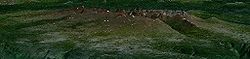
The Level Mountain Range, also known as Level Mountain, is a mountain range
in Cassiar Country
, northwestern British Columbia
, Canada
, located just northeast of Callison Ranch, southwest of Dease Lake
and about 50 km (31 mi) north of Mount Edziza
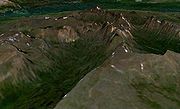
. It consists of a massive shield volcano
and lies on the Nahlin Plateau
, comprising a series of butte
s and ridges. The range is lightly glaciated, as compared to the Coast Mountains
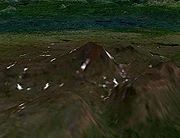
just to the west. The only named mountain in the Level Mountain Range is Meszah Peak
on the north side of the range with an elevation of 2190 m (7,185 ft), making it the highest point of the Level Mountain Range. Immediately to the west, however, are the Heart Peaks
, a related volcanic range just east of the Sheslay River
, which is the edge of the Nahlin Plateau.
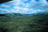
The Level Mountain Range rises above adjacent forested lowlands and undulating alpine areas surround the steeper central peaks. Streams that originate from these peaks drain across the Nahlin Plateau.
to the northeast. Wolf predation is considered to be an instrumental factor in producing the current pattern of caribou habitat use. Wolves were most commonly observed in 1980 in the valleys, but mountainous areas were also used for denning and hunting. Grizzly bears were also common in the mountainous portions of the Level Mountain Range and are potentially significant predators of young caribou calves. Other hoofed mammals included mountain goat
, Dall Sheep
, and moose
.
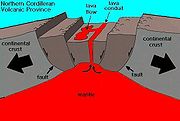 The Level Mountain Range began forming about 14.9 million years ago and has grown steadily since then. Like other volcanoes in northwestern British Columbia, the Level Mountain Range has its origins in continental
rift
ing—a long divergent plate boundary
where the lithosphere
is being pulled apart. Here, the continental crust
of the North American Plate
is being stretched at a rate of about 2 cm (0.78740157480315 in) per year. This incipient rifting has formed as a result of the Pacific Plate
sliding northward along the Queen Charlotte Fault
, on its way to the Aleutian Trench
, which extends along the southern coastline of Alaska
and the adjacent waters of northeastern Siberia
off the coast of Kamchatka Peninsula
. As the continental crust stretches, the near-surface rocks fracture along steeply dipping cracks parallel to the rift known as faults. Hot basalt
ic magma
rises along these fractures to create passive lava eruptions, known as effusive eruption
s.
The rift zone has existed for at least 20 million years, and has created a line of volcanoes called the Northern Cordilleran Volcanic Province
, also called the Stikine Volcanic Belt, stretching from the Alaska
-Yukon
border to near Prince Rupert, British Columbia
. Several presently dormant volcanoes in the province are potentially active, three of them having erupted in the last few hundred years, two witnessed by First Nations
and placer miners
during the 18th and 19th centuries. Tseax Cone
, which last erupted in the 18th century, is the southernmost historically active volcano in the province, while Prindle Volcano in east-central Alaska, which erupted during the Pleistocene
period, is generally considered the northernmost.
 The Level Mountain Range is the most voluminous and most persistent volcano of the Northern Cordilleran Volcanic Province with an area of 1800 km2 and is the earliest locus of volcanism within the volcanic province. More than 20 Tertiary
-to-Holocene
volcanic vents have been identified in the central portion of the Level Mountain Range and on its flanks, although Holocene activity (10,000 years ago to present) remains uncertain. It is straddled by two major northwest trending planer rock fractures called the King Salmon Fault and the Nahlin Fault, which were active during the Mesozoic
/Cenozoic
eras. The history of the Level Mountain Range records glaciation extending back to the Pliocene
period which extends from 5.332 million to 1.806 million years ago", affording numerous examples of the interaction of volcanic and glacial processes. Even though the Level Mountain Range is adjacent to the broad Tuya Volcanic Field
, it is not considered part of the same volcanic formation because the Level Mountain Range is a long-lived volcano whereas the Tuya Volcanic Field consists of small volcanoes noted for having only one short eruptive event.
and continental rift
volcanism with leaky transform settings.
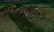
period. The shield volcano forms a broad cliff-bounded lava plateau, 70 km (43 mi) long and 45 km (28 mi) wide, with an average thickness of 750 m (2,461 ft) and an elevation of 1400 m (4,593 ft) on the eroded Nahlin Plateau marking extensive Neogene
regional uplift. The shield is built of four distinctive stratigraphic units dominated by 1 to 8 m thick basaltic lava flows separated by thin discontinuous breccias, sporadic tuff horizons, and local lenses of fluvial, lacustrine, and glacial sediment. Ropy pahoehoe lava flows predominate over blocky aa lava flows, breccias, and tuffs, attesting to a fluid and effusive character for the volcanism. Radial flow directions and quaquaversal dips suggest that most lava flows originated from central vents rather than flank vents. Long masses of magmatic rock exist throughout the shield but are rare, thin, and radially oriented. These long masses of magmatic rock, known as dikes
, are intermittent features related to high-level volcanotectonic processess within the shield.
 The near finished stages of the shield-forming phase was overlapped by another eruptive period starting 7.1 million years ago, forming a massive bimodal stratovolcano
. This 860 km3 stratovolcano functions as a volcanic plug
centrally located atop the shield and comprises several volcanic vents, some of which were formerly more than 2500 m (8,202 ft) in elevation. The stratigraphy of the stratovolcano is complex due to the influence of adjacent vents and to the tremendous variation in the erupted magmas (oversaturated, undersaturated, peralkaline, and metaluminous). Five bimodal packages of lava flows and ejecta comprise the stratovolcano. Felsic compositions dominate more than 80% of the stratovolcano's volume with peralkaline volcanic rocks, trachyte
and comendite
being the most common.
Peralkaline magmas had remarkable effects on lava flow morphology and mineralogy. Low volume flows (7 km long x 3 to 8 m thick), with small-scale flow folds and lava tube
s reaching 1 to 2 m in diameter and thin dikes up to 1 m (3 ft) thick, owed their fluidity to liquidus temperatures in excess of 1,200°C and viscosities as low as 105 poise. These physical properties are atypical for melts of such high silica content.
 The shield-forming phase eventually ended 6.9 million years ago whereas the stratovolcano-forming phase ended 5.3 million years ago. Widespread evidence for contemporaneous volcanism and glaciation is present in the upperpart of the shield and in the stratovolcano. This evidence includes flat-topped, steep-sided volcanoes on the uppermost surface of the shield called tuya
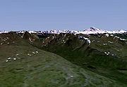
s and as outliers, tills and glacial erratics at the base of lava flows and tuffs, till cemented by siliceous sinter, lahars made up of till and agglomerate, volcano-glacial tuff breccias, interlayered unconsoildated fluvioglacial and tuffaceous deposits, and freshwater pillow basalts. The tuyas within the Level Mountain Range formed when magma intruded into and melted a vertical pipe in the overlying continental ice sheets that existed during this period of volcanic activity. The partially molten mass cooled as a large block, with gravity flattening its upper surface. The shield margins have been sculpted by continental ice, and its uppermost member includes volcano-glacial facies. Radially directed alpine glaciers and streams have dissected the stratovolcano into a series of U-shaped valleys with intervening ridges that constitute the Level Mountain Range proper. This and the light snowfall covering the dissected stratovolcano offers a unique opportunity to view cross sections through an effusive peralkaline volcano.
 The final phase of activity constructed a series of lava dome
s 4.5 million years ago that post-date the alpine valley system and cut the glacially eroded core of the stratovolcano. Individual lava domes have volumes up to 9.4 x 10⁷m3 and headward erosion has further modified the volcano by incising youthful V-shaped stream canyons into the lava plateau margin. This is the local expression of continuing regional uplift with canyon development on all of the adjacent major river systems, including the Stikine River with its prominent section of Tertiary basalts. Lesser volcanic activity continued into the Quaternary
until 2.5 million years ago when dome-forming eruptions ceased.
Mountain range
A mountain range is a single, large mass consisting of a succession of mountains or narrowly spaced mountain ridges, with or without peaks, closely related in position, direction, formation, and age; a component part of a mountain system or of a mountain chain...
in Cassiar Country
Cassiar Country
The Cassiar Country, also referred to simply as the Cassiar, is one of the historical geographic regions of the Canadian province of British Columbia...
, northwestern British Columbia
British Columbia
British Columbia is the westernmost of Canada's provinces and is known for its natural beauty, as reflected in its Latin motto, Splendor sine occasu . Its name was chosen by Queen Victoria in 1858...
, Canada
Canada
Canada is a North American country consisting of ten provinces and three territories. Located in the northern part of the continent, it extends from the Atlantic Ocean in the east to the Pacific Ocean in the west, and northward into the Arctic Ocean...
, located just northeast of Callison Ranch, southwest of Dease Lake
Dease Lake, British Columbia
Dease Lake is a small community located in the Cassiar Country of the Northern Interior of British Columbia, Canada. Located only a few hours south of the Yukon border, it is located on Highway 37 at the south end of the lake of the same name. Dease Lake is the last major centre before the Alaska...
and about 50 km (31 mi) north of Mount Edziza
Mount Edziza
Mount Edziza is a stratovolcano in the Stikine Country of northwestern British Columbia, Canada. The volcano and the surrounding area are protected within Mount Edziza Provincial Park. It consists of a complex of multiple peaks and ridges, with several glaciers flowing in all directions. The summit...
. It consists of a massive shield volcano
Shield volcano
A shield volcano is a type of volcano usually built almost entirely of fluid lava flows. They are named for their large size and low profile, resembling a warrior's shield. This is caused by the highly fluid lava they erupt, which travels farther than lava erupted from more explosive volcanoes...
and lies on the Nahlin Plateau
Nahlin Plateau
The Nahlin Plateau is a plateau in northwestern British Columbia, Canada, located between the Sheslay River and Tuya River on the west and east and the Nahlin River and the Stikine River to the north and south...
, comprising a series of butte
Butte
A butte is a conspicuous isolated hill with steep, often vertical sides and a small, relatively flat top; it is smaller than mesas, plateaus, and table landform tables. In some regions, such as the north central and northwestern United States, the word is used for any hill...
s and ridges. The range is lightly glaciated, as compared to the Coast Mountains
Coast Mountains
The Coast Mountains are a major mountain range, in the Pacific Coast Ranges, of western North America, extending from southwestern Yukon through the Alaska Panhandle and virtually all of the Coast of British Columbia. They are so-named because of their proximity to the sea coast, and are often...
just to the west. The only named mountain in the Level Mountain Range is Meszah Peak
Meszah Peak
Meszah Peak is a volcanic cone located north of Telegraph Creek and southwest of Zus Mountain. It is the highest mountain of the Level Mountain Range, a massive shield volcano forming the most voluminous and most persistent eruptive centre in the Northern Cordilleran Volcanic Province.-See also:*...
on the north side of the range with an elevation of 2190 m (7,185 ft), making it the highest point of the Level Mountain Range. Immediately to the west, however, are the Heart Peaks
Heart Peaks
Heart Peaks, originally known as the Heart Mountains, is a mountain massif in the Northern Interior of British Columbia, Canada. It is located northwest of the small community of Telegraph Creek and just southwest of Callison Ranch. With a maximum elevation of , it rises above the surrounding...
, a related volcanic range just east of the Sheslay River
Sheslay River
The Sheslay River is a river in far northwestern British Columbia in the southeast portion of the basin of the Taku River. The river is 85 km in length from the confluence of the Hackett River to the junction of the Nahlin River, which is the commencement of the Inklin River, the main SE...
, which is the edge of the Nahlin Plateau.
The Level Mountain Range rises above adjacent forested lowlands and undulating alpine areas surround the steeper central peaks. Streams that originate from these peaks drain across the Nahlin Plateau.
Biology
The Level Mountain Range contains a large variety of species. In 1978, more than 400 caribou were estimated in the Level Mountain Range but the herd was thought to be decreasing because of poor recruitment. Calf percentages averaged less than 10%. Approximately 350 caribou were counted in 1980, but only half that number were actually estimated. Wolf density was estimated at about 1/100 km2, and was thought to be similar to the initial density of the 40 km (25 mi) long Horseranch RangeHorseranch Range
The Horseranch Range is a long north-south trending mountain range in northern British Columbia, Canada, located at the head of the Red River to the northwest of Deadwood Lake. Part of the Dease Plateau of the Cassiar Mountains system, it contains no glaciers and lies completely above tree...
to the northeast. Wolf predation is considered to be an instrumental factor in producing the current pattern of caribou habitat use. Wolves were most commonly observed in 1980 in the valleys, but mountainous areas were also used for denning and hunting. Grizzly bears were also common in the mountainous portions of the Level Mountain Range and are potentially significant predators of young caribou calves. Other hoofed mammals included mountain goat
Mountain goat
The Mountain Goat , also known as the Rocky Mountain Goat, is a large-hoofed mammal found only in North America. Despite its vernacular name, it is not a member of Capra, the genus of true goats...
, Dall Sheep
Dall Sheep
The Dall sheep , Ovis dalli, is a species of sheep native to northwestern North America, ranging from white to slate brown in color and having curved yellowish brown horns...
, and moose
Moose
The moose or Eurasian elk is the largest extant species in the deer family. Moose are distinguished by the palmate antlers of the males; other members of the family have antlers with a dendritic configuration...
.
Origins
Continent
A continent is one of several very large landmasses on Earth. They are generally identified by convention rather than any strict criteria, with seven regions commonly regarded as continents—they are : Asia, Africa, North America, South America, Antarctica, Europe, and Australia.Plate tectonics is...
rift
Rift
In geology, a rift or chasm is a place where the Earth's crust and lithosphere are being pulled apart and is an example of extensional tectonics....
ing—a long divergent plate boundary
Divergent boundary
In plate tectonics, a divergent boundary or divergent plate boundary is a linear feature that exists between two tectonic plates that are moving away from each other. Divergent boundaries within continents initially produce rifts which produce rift valleys...
where the lithosphere
Lithosphere
The lithosphere is the rigid outermost shell of a rocky planet. On Earth, it comprises the crust and the portion of the upper mantle that behaves elastically on time scales of thousands of years or greater.- Earth's lithosphere :...
is being pulled apart. Here, the continental crust
Continental crust
The continental crust is the layer of igneous, sedimentary, and metamorphic rocks which form the continents and the areas of shallow seabed close to their shores, known as continental shelves. This layer is sometimes called sial due to more felsic, or granitic, bulk composition, which lies in...
of the North American Plate
North American Plate
The North American Plate is a tectonic plate covering most of North America, Greenland, Cuba, Bahamas, and parts of Siberia, Japan and Iceland. It extends eastward to the Mid-Atlantic Ridge and westward to the Chersky Range in eastern Siberia. The plate includes both continental and oceanic crust...
is being stretched at a rate of about 2 cm (0.78740157480315 in) per year. This incipient rifting has formed as a result of the Pacific Plate
Pacific Plate
The Pacific Plate is an oceanic tectonic plate that lies beneath the Pacific Ocean. At 103 million square kilometres, it is the largest tectonic plate....
sliding northward along the Queen Charlotte Fault
Queen Charlotte Fault
The Queen Charlotte Fault is an active transform fault, located between the North American Plate and the Pacific Plate, Canada's equivalent of the San Andreas Fault. The Queen Charlotte Fault forms a triple junction on its south with the Cascadia subduction zone and the Explorer Ridge...
, on its way to the Aleutian Trench
Aleutian Trench
The Aleutian Trench is a subduction zone and oceanic trench which runs along the southern coastline of Alaska and the adjacent waters of northeastern Siberia off the coast of Kamchatka Peninsula. It is classified as a "marginal trench" in the east as it runs along the margin of the continent, and...
, which extends along the southern coastline of Alaska
Alaska
Alaska is the largest state in the United States by area. It is situated in the northwest extremity of the North American continent, with Canada to the east, the Arctic Ocean to the north, and the Pacific Ocean to the west and south, with Russia further west across the Bering Strait...
and the adjacent waters of northeastern Siberia
Siberia
Siberia is an extensive region constituting almost all of Northern Asia. Comprising the central and eastern portion of the Russian Federation, it was part of the Soviet Union from its beginning, as its predecessor states, the Tsardom of Russia and the Russian Empire, conquered it during the 16th...
off the coast of Kamchatka Peninsula
Kamchatka Peninsula
The Kamchatka Peninsula is a peninsula in the Russian Far East, with an area of . It lies between the Pacific Ocean to the east and the Sea of Okhotsk to the west...
. As the continental crust stretches, the near-surface rocks fracture along steeply dipping cracks parallel to the rift known as faults. Hot basalt
Basalt
Basalt is a common extrusive volcanic rock. It is usually grey to black and fine-grained due to rapid cooling of lava at the surface of a planet. It may be porphyritic containing larger crystals in a fine matrix, or vesicular, or frothy scoria. Unweathered basalt is black or grey...
ic magma
Magma
Magma is a mixture of molten rock, volatiles and solids that is found beneath the surface of the Earth, and is expected to exist on other terrestrial planets. Besides molten rock, magma may also contain suspended crystals and dissolved gas and sometimes also gas bubbles. Magma often collects in...
rises along these fractures to create passive lava eruptions, known as effusive eruption
Effusive eruption
An effusive eruption is a volcanic eruption characterized by the outpouring of lava onto the ground...
s.
The rift zone has existed for at least 20 million years, and has created a line of volcanoes called the Northern Cordilleran Volcanic Province
Northern Cordilleran volcanic province
The Northern Cordilleran Volcanic Province , formerly known as the Stikine Volcanic Belt, is a geologic province defined by the occurrence of Miocene to Holocene volcanoes in the Pacific Northwest of North America...
, also called the Stikine Volcanic Belt, stretching from the Alaska
Alaska
Alaska is the largest state in the United States by area. It is situated in the northwest extremity of the North American continent, with Canada to the east, the Arctic Ocean to the north, and the Pacific Ocean to the west and south, with Russia further west across the Bering Strait...
-Yukon
Yukon
Yukon is the westernmost and smallest of Canada's three federal territories. It was named after the Yukon River. The word Yukon means "Great River" in Gwich’in....
border to near Prince Rupert, British Columbia
Prince Rupert, British Columbia
Prince Rupert is a port city in the province of British Columbia, Canada. It is the land, air, and water transportation hub of British Columbia's North Coast, and home to some 12,815 people .-History:...
. Several presently dormant volcanoes in the province are potentially active, three of them having erupted in the last few hundred years, two witnessed by First Nations
First Nations
First Nations is a term that collectively refers to various Aboriginal peoples in Canada who are neither Inuit nor Métis. There are currently over 630 recognised First Nations governments or bands spread across Canada, roughly half of which are in the provinces of Ontario and British Columbia. The...
and placer miners
Placer mining
Placer mining is the mining of alluvial deposits for minerals. This may be done by open-pit or by various surface excavating equipment or tunneling equipment....
during the 18th and 19th centuries. Tseax Cone
Tseax Cone
The Tseax Cone , also called the Tseax River Cone or alternately the Aiyansh Volcano, is a young cinder cone and adjacent lava flows associated with the Nass Ranges and the Northern Cordilleran Volcanic Province...
, which last erupted in the 18th century, is the southernmost historically active volcano in the province, while Prindle Volcano in east-central Alaska, which erupted during the Pleistocene
Pleistocene
The Pleistocene is the epoch from 2,588,000 to 11,700 years BP that spans the world's recent period of repeated glaciations. The name pleistocene is derived from the Greek and ....
period, is generally considered the northernmost.
Structure
Tertiary
The Tertiary is a deprecated term for a geologic period 65 million to 2.6 million years ago. The Tertiary covered the time span between the superseded Secondary period and the Quaternary...
-to-Holocene
Holocene
The Holocene is a geological epoch which began at the end of the Pleistocene and continues to the present. The Holocene is part of the Quaternary period. Its name comes from the Greek words and , meaning "entirely recent"...
volcanic vents have been identified in the central portion of the Level Mountain Range and on its flanks, although Holocene activity (10,000 years ago to present) remains uncertain. It is straddled by two major northwest trending planer rock fractures called the King Salmon Fault and the Nahlin Fault, which were active during the Mesozoic
Mesozoic
The Mesozoic era is an interval of geological time from about 250 million years ago to about 65 million years ago. It is often referred to as the age of reptiles because reptiles, namely dinosaurs, were the dominant terrestrial and marine vertebrates of the time...
/Cenozoic
Cenozoic
The Cenozoic era is the current and most recent of the three Phanerozoic geological eras and covers the period from 65.5 mya to the present. The era began in the wake of the Cretaceous–Tertiary extinction event at the end of the Cretaceous that saw the demise of the last non-avian dinosaurs and...
eras. The history of the Level Mountain Range records glaciation extending back to the Pliocene
Pliocene
The Pliocene Epoch is the period in the geologic timescale that extends from 5.332 million to 2.588 million years before present. It is the second and youngest epoch of the Neogene Period in the Cenozoic Era. The Pliocene follows the Miocene Epoch and is followed by the Pleistocene Epoch...
period which extends from 5.332 million to 1.806 million years ago", affording numerous examples of the interaction of volcanic and glacial processes. Even though the Level Mountain Range is adjacent to the broad Tuya Volcanic Field
Tuya Volcanic Field
The Tuya volcanic field is a volcanic field of tuyas located in far northern British Columbia, Canada, near the border with the Yukon Territory and focussed on the area of the Tuya Range, a subrange of the Stikine Ranges of the Cassiar Mountains, though some vents are in the Kawdy Plateau, the...
, it is not considered part of the same volcanic formation because the Level Mountain Range is a long-lived volcano whereas the Tuya Volcanic Field consists of small volcanoes noted for having only one short eruptive event.
Eruptive history
The Level Mountain Range was formed during three phases of volcanic activity. From trace elements and isotope systematics, the origin of the lavas that form the Level Mountain Range requires an upper mantle source for both the basaltic and the salic lavas. Refractory xenocrysts (olivine, orthopyroxene, spinel) from Level Mountain basalt and spinel lherzolites from nearby vents in the Stikine Canyon and at Castle Rock support this contention. The bimodal sodic alkalic lava suite at Level Mountain is typical of hotspotHotspot (geology)
The places known as hotspots or hot spots in geology are volcanic regions thought to be fed by underlying mantle that is anomalously hot compared with the mantle elsewhere. They may be on, near to, or far from tectonic plate boundaries. There are two hypotheses to explain them...
and continental rift
Rift
In geology, a rift or chasm is a place where the Earth's crust and lithosphere are being pulled apart and is an example of extensional tectonics....
volcanism with leaky transform settings.
Shield volcano eruptive period
The first phase of activity resulted in the creation of the massive oval-shaped shield volcano 14.9 million years ago during the mid-MioceneMiocene
The Miocene is a geological epoch of the Neogene Period and extends from about . The Miocene was named by Sir Charles Lyell. Its name comes from the Greek words and and means "less recent" because it has 18% fewer modern sea invertebrates than the Pliocene. The Miocene follows the Oligocene...
period. The shield volcano forms a broad cliff-bounded lava plateau, 70 km (43 mi) long and 45 km (28 mi) wide, with an average thickness of 750 m (2,461 ft) and an elevation of 1400 m (4,593 ft) on the eroded Nahlin Plateau marking extensive Neogene
Neogene
The Neogene is a geologic period and system in the International Commission on Stratigraphy Geologic Timescale starting 23.03 ± 0.05 million years ago and ending 2.588 million years ago...
regional uplift. The shield is built of four distinctive stratigraphic units dominated by 1 to 8 m thick basaltic lava flows separated by thin discontinuous breccias, sporadic tuff horizons, and local lenses of fluvial, lacustrine, and glacial sediment. Ropy pahoehoe lava flows predominate over blocky aa lava flows, breccias, and tuffs, attesting to a fluid and effusive character for the volcanism. Radial flow directions and quaquaversal dips suggest that most lava flows originated from central vents rather than flank vents. Long masses of magmatic rock exist throughout the shield but are rare, thin, and radially oriented. These long masses of magmatic rock, known as dikes
Dike (geology)
A dike or dyke in geology is a type of sheet intrusion referring to any geologic body that cuts discordantly across* planar wall rock structures, such as bedding or foliation...
, are intermittent features related to high-level volcanotectonic processess within the shield.
Stratovolcano eruptive period
Stratovolcano
A stratovolcano, also known as a composite volcano, is a tall, conical volcano built up by many layers of hardened lava, tephra, pumice, and volcanic ash. Unlike shield volcanoes, stratovolcanoes are characterized by a steep profile and periodic, explosive eruptions...
. This 860 km3 stratovolcano functions as a volcanic plug
Volcanic plug
A volcanic plug, also called a volcanic neck or lava neck, is a volcanic landform created when magma hardens within a vent on an active volcano. When forming, a plug can cause an extreme build-up of pressure if volatile-charged magma is trapped beneath it, and this can sometimes lead to an...
centrally located atop the shield and comprises several volcanic vents, some of which were formerly more than 2500 m (8,202 ft) in elevation. The stratigraphy of the stratovolcano is complex due to the influence of adjacent vents and to the tremendous variation in the erupted magmas (oversaturated, undersaturated, peralkaline, and metaluminous). Five bimodal packages of lava flows and ejecta comprise the stratovolcano. Felsic compositions dominate more than 80% of the stratovolcano's volume with peralkaline volcanic rocks, trachyte
Trachyte
Trachyte is an igneous volcanic rock with an aphanitic to porphyritic texture. The mineral assemblage consists of essential alkali feldspar; relatively minor plagioclase and quartz or a feldspathoid such as nepheline may also be present....
and comendite
Comendite
Comendite is a hard, peralkaline igneous rock, a type of light blue grey rhyolite. Phenocrysts are sodic sanidine with minor albite and bipyrimidal quartz. Comendite occurs in the mountains Tibrogargan, Coonowrin, Tunbubudla, Coochin, Saddleback, Tibberoowuccum and Ngungun in the Glass House...
being the most common.
Peralkaline magmas had remarkable effects on lava flow morphology and mineralogy. Low volume flows (7 km long x 3 to 8 m thick), with small-scale flow folds and lava tube
Lava tube
Lava tubes are natural conduits through which lava travels beneath the surface of a lava flow, expelled by a volcano during an eruption. They can be actively draining lava from a source, or can be extinct, meaning the lava flow has ceased and the rock has cooled and left a long, cave-like...
s reaching 1 to 2 m in diameter and thin dikes up to 1 m (3 ft) thick, owed their fluidity to liquidus temperatures in excess of 1,200°C and viscosities as low as 105 poise. These physical properties are atypical for melts of such high silica content.
Tuya
A tuya is a type of distinctive, flat-topped, steep-sided volcano formed when lava erupts through a thick glacier or ice sheet. They are somewhat rare worldwide, being confined to regions which were covered by glaciers and also had active volcanism during the same time period.-Formation:Tuyas are...
s and as outliers, tills and glacial erratics at the base of lava flows and tuffs, till cemented by siliceous sinter, lahars made up of till and agglomerate, volcano-glacial tuff breccias, interlayered unconsoildated fluvioglacial and tuffaceous deposits, and freshwater pillow basalts. The tuyas within the Level Mountain Range formed when magma intruded into and melted a vertical pipe in the overlying continental ice sheets that existed during this period of volcanic activity. The partially molten mass cooled as a large block, with gravity flattening its upper surface. The shield margins have been sculpted by continental ice, and its uppermost member includes volcano-glacial facies. Radially directed alpine glaciers and streams have dissected the stratovolcano into a series of U-shaped valleys with intervening ridges that constitute the Level Mountain Range proper. This and the light snowfall covering the dissected stratovolcano offers a unique opportunity to view cross sections through an effusive peralkaline volcano.
Lava dome eruptive period
Lava dome
|250px|thumb|right|Image of the [[rhyolitic]] lava dome of [[Chaitén Volcano]] during its 2008–2009 eruption.In volcanology, a lava dome is a roughly circular mound-shaped protrusion resulting from the slow extrusion of viscous lava from a volcano...
s 4.5 million years ago that post-date the alpine valley system and cut the glacially eroded core of the stratovolcano. Individual lava domes have volumes up to 9.4 x 10⁷m3 and headward erosion has further modified the volcano by incising youthful V-shaped stream canyons into the lava plateau margin. This is the local expression of continuing regional uplift with canyon development on all of the adjacent major river systems, including the Stikine River with its prominent section of Tertiary basalts. Lesser volcanic activity continued into the Quaternary
Quaternary
The Quaternary Period is the most recent of the three periods of the Cenozoic Era in the geologic time scale of the ICS. It follows the Neogene Period, spanning 2.588 ± 0.005 million years ago to the present...
until 2.5 million years ago when dome-forming eruptions ceased.
See also
- Volcanism of Canada
- Volcanism of Western CanadaVolcanism of Western CanadaVolcanism of Western Canada produces lava flows, lava plateaus, lava domes, cinder cones, stratovolcanoes, shield volcanoes, submarine volcanoes, calderas, diatremes and maars, along with examples of more less common volcanic forms such as tuyas and subglacial mounds.-Volcanic belts:*Anahim...
- List of Northern Cordilleran volcanoes
- List of volcanoes in Canada
External links
- Volcanoes of Canada Stikine Volcanic Belt (Level Mountain area)
- Catalogue of Canadian volcanoes - Level Mountain