

Iceland hotspot
Encyclopedia
Hotspot (geology)
The places known as hotspots or hot spots in geology are volcanic regions thought to be fed by underlying mantle that is anomalously hot compared with the mantle elsewhere. They may be on, near to, or far from tectonic plate boundaries. There are two hypotheses to explain them...
which is partly responsible for the high volcanic activity which has formed the island of Iceland
Iceland
Iceland , described as the Republic of Iceland, is a Nordic and European island country in the North Atlantic Ocean, on the Mid-Atlantic Ridge. Iceland also refers to the main island of the country, which contains almost all the population and almost all the land area. The country has a population...
.
Description
Iceland is one of the most active volcanicVolcano
2. Bedrock3. Conduit 4. Base5. Sill6. Dike7. Layers of ash emitted by the volcano8. Flank| 9. Layers of lava emitted by the volcano10. Throat11. Parasitic cone12. Lava flow13. Vent14. Crater15...
regions in the world, with eruptions occurring on average roughly every three years (in the 20th century there were 39 volcanic eruptions on and around Iceland). About a third of the basalt
Basalt
Basalt is a common extrusive volcanic rock. It is usually grey to black and fine-grained due to rapid cooling of lava at the surface of a planet. It may be porphyritic containing larger crystals in a fine matrix, or vesicular, or frothy scoria. Unweathered basalt is black or grey...
ic lava
Lava
Lava refers both to molten rock expelled by a volcano during an eruption and the resulting rock after solidification and cooling. This molten rock is formed in the interior of some planets, including Earth, and some of their satellites. When first erupted from a volcanic vent, lava is a liquid at...
s erupted in recorded history have been produced by Icelandic eruptions. Notable eruptions have included that of Eldgjá
Eldgjá
Eldgjá is a volcanic canyon in Iceland. Eldgjá and the Katla volcano are part of the same volcanic system in the south of the country. Eldgjá means "fire canyon" in Icelandic....
, a fissure of Katla
Katla
Katla is one of the largest volcanoes in Iceland. It is situated to the north of Vík í Mýrdal and to the east of the smaller glacier Eyjafjallajökull. Its peak reaches in height and is partially covered by the Mýrdalsjökull glacier. The Eldgjá canyon is part of the same volcanic system...
, in 984 (the world's largest basaltic eruption ever witnessed), Laki
Laki
Łąki may refer to the following places in Poland:*Łąki, Lower Silesian Voivodeship *Łąki, West Pomeranian Voivodeship *Łąki, Lublin Voivodeship...
in 1783 (the world's second largest), and several eruptions beneath ice cap
Ice cap
An ice cap is an ice mass that covers less than 50 000 km² of land area . Masses of ice covering more than 50 000 km² are termed an ice sheet....
s, which have generated devastating glacial bursts
Jökulhlaup
A jökulhlaup is a glacial outburst flood. It is an Icelandic term that has been adopted by the English language. It originally referred to the well-known subglacial outburst floods from Vatnajökull, Iceland which are triggered by geothermal heating and occasionally by a volcanic subglacial...
, most recently in 2010 after the eruption of Eyjafjallajökull
Eyjafjallajökull
Eyjafjallajökull is one of the smaller ice caps of Iceland, situated to the north of Skógar and to the west of Mýrdalsjökull. The ice cap covers the caldera of a volcano with a summit elevation of . The volcano has erupted relatively frequently since the last glacial period, most recently in...
.
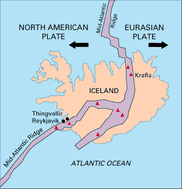
Iceland's location astride the Mid-Atlantic Ridge
Mid-Atlantic Ridge
The Mid-Atlantic Ridge is a mid-ocean ridge, a divergent tectonic plate boundary located along the floor of the Atlantic Ocean, and part of the longest mountain range in the world. It separates the Eurasian Plate and North American Plate in the North Atlantic, and the African Plate from the South...
, where the Eurasian
Eurasian Plate
The Eurasian Plate is a tectonic plate which includes most of the continent of Eurasia , with the notable exceptions of the Indian subcontinent, the Arabian subcontinent, and the area east of the Chersky Range in East Siberia...
and North American Plate
North American Plate
The North American Plate is a tectonic plate covering most of North America, Greenland, Cuba, Bahamas, and parts of Siberia, Japan and Iceland. It extends eastward to the Mid-Atlantic Ridge and westward to the Chersky Range in eastern Siberia. The plate includes both continental and oceanic crust...
s are moving apart, is partly responsible for this intense volcanic activity, but an additional cause is necessary to explain why Iceland is a substantial island while the rest of the ridge mostly consists of seamount
Seamount
A seamount is a mountain rising from the ocean seafloor that does not reach to the water's surface , and thus is not an island. These are typically formed from extinct volcanoes, that rise abruptly and are usually found rising from a seafloor of depth. They are defined by oceanographers as...
s, with peaks below sea level
Sea level
Mean sea level is a measure of the average height of the ocean's surface ; used as a standard in reckoning land elevation...
.
As well as being a region of higher temperature than the surrounding mantle
Mantle (geology)
The mantle is a part of a terrestrial planet or other rocky body large enough to have differentiation by density. The interior of the Earth, similar to the other terrestrial planets, is chemically divided into layers. The mantle is a highly viscous layer between the crust and the outer core....
, it is also believed to have a higher concentration of water
Water
Water is a chemical substance with the chemical formula H2O. A water molecule contains one oxygen and two hydrogen atoms connected by covalent bonds. Water is a liquid at ambient conditions, but it often co-exists on Earth with its solid state, ice, and gaseous state . Water also exists in a...
. The presence of water in magma
Magma
Magma is a mixture of molten rock, volatiles and solids that is found beneath the surface of the Earth, and is expected to exist on other terrestrial planets. Besides molten rock, magma may also contain suspended crystals and dissolved gas and sometimes also gas bubbles. Magma often collects in...
reduces the melting temperature, and this may also play a role in enhancing Icelandic volcanism.
Theories of causation
There is an ongoing discussion whether the hotspot is caused by a deep mantle plumeMantle plume
A mantle plume is a hypothetical thermal diapir of abnormally hot rock that nucleates at the core-mantle boundary and rises through the Earth's mantle. Such plumes were invoked in 1971 to explain volcanic regions that were not thought to be explicable by the then-new theory of plate tectonics. Some...
or originates at a much shallower depth.
Some geologist
Geologist
A geologist is a scientist who studies the solid and liquid matter that constitutes the Earth as well as the processes and history that has shaped it. Geologists usually engage in studying geology. Geologists, studying more of an applied science than a theoretical one, must approach Geology using...
s have questioned whether the Iceland hotspot has the same origin as other hotspots such as the Hawaii hotspot
Hawaii hotspot
The Hawaii hotspot is the volcanic hotspot that created the Hawaiian Islands in the central Pacific Ocean, and is one of Earth's best-known and most heavily-studied hotspots....
. While the Hawaiian island chain and the Emperor Seamounts show a clear time-progressive volcanic track caused by the movement of the Pacific Plate
Pacific Plate
The Pacific Plate is an oceanic tectonic plate that lies beneath the Pacific Ocean. At 103 million square kilometres, it is the largest tectonic plate....
over the Hawaiian hotspot, no such track can be seen at Iceland.
It is proposed that the line Grímsvötn
Grímsvötn
The Grímsvötn sub-glacial lakes and the volcano of the same name are in South-East Iceland. They are in the highlands of Iceland at the northwestern side of the Vatnajökull ice-cap. The lakes are at , at an elevation of...
volcano to Surtsey
Surtsey
Surtsey is a volcanic island off the southern coast of Iceland. At it is also the southernmost point of Iceland. It was formed in a volcanic eruption which began 130 metres below sea level, and reached the surface on 15 November 1963. The eruption lasted until 5 June 1967, when the island...
shows the movement of the Eurasian Plate
Eurasian Plate
The Eurasian Plate is a tectonic plate which includes most of the continent of Eurasia , with the notable exceptions of the Indian subcontinent, the Arabian subcontinent, and the area east of the Chersky Range in East Siberia...
and the line Grímsvötn
Grímsvötn
The Grímsvötn sub-glacial lakes and the volcano of the same name are in South-East Iceland. They are in the highlands of Iceland at the northwestern side of the Vatnajökull ice-cap. The lakes are at , at an elevation of...
volcano to Snæfellsnes
Snæfellsnes
The Snæfellsnes is a peninsula situated to the west of Borgarfjörður, in western of Iceland.It has been named Iceland in Miniature, as many national sights can be found in the area, including the Snæfellsjökull volcano, regarded as one of the symbols of Iceland. With its height of 1446 m, it...
volcanic belt shows the movement of the North American Plate
North American Plate
The North American Plate is a tectonic plate covering most of North America, Greenland, Cuba, Bahamas, and parts of Siberia, Japan and Iceland. It extends eastward to the Mid-Atlantic Ridge and westward to the Chersky Range in eastern Siberia. The plate includes both continental and oceanic crust...
.
Mantle plume theory
It is believed that a mantle plumeMantle plume
A mantle plume is a hypothetical thermal diapir of abnormally hot rock that nucleates at the core-mantle boundary and rises through the Earth's mantle. Such plumes were invoked in 1971 to explain volcanic regions that were not thought to be explicable by the then-new theory of plate tectonics. Some...
underlies Iceland, of which the hotspot is thought to be the surface expression. This enhances the volcanism already caused by plate separation, both at the centre of the island and at the Reykjanes
Reykjanes
Reykjanes or Reykjanesskagi is a peninsula and a volcanic system situated at the south-western end of Iceland, near the capital of Reykjavík....
ridge to the southwest of Iceland's main volcanic zone. The plume is believed to be quite narrow, perhaps 100 km across, and extends down to at least 400–650 km beneath the Earth's surface, and possibly down to the core-mantle boundary.
Studies suggest that the hotspot is only 50-100 K
Kelvin
The kelvin is a unit of measurement for temperature. It is one of the seven base units in the International System of Units and is assigned the unit symbol K. The Kelvin scale is an absolute, thermodynamic temperature scale using as its null point absolute zero, the temperature at which all...
hotter than its surroundings, which may not be a great enough difference to drive a buoyant
Buoyancy
In physics, buoyancy is a force exerted by a fluid that opposes an object's weight. In a column of fluid, pressure increases with depth as a result of the weight of the overlying fluid. Thus a column of fluid, or an object submerged in the fluid, experiences greater pressure at the bottom of the...
plume.
It is suggested that the lack of a time-progressive track is because the plume may have been located beneath the thick Greenland craton
Craton
A craton is an old and stable part of the continental lithosphere. Having often survived cycles of merging and rifting of continents, cratons are generally found in the interiors of tectonic plates. They are characteristically composed of ancient crystalline basement rock, which may be covered by...
for a significant time.
See also
- Geography of IcelandGeography of IcelandIceland is a medium-sized island in the North Atlantic ocean. The island is located east of Greenland and immediately south of the Arctic Circle, atop the divergent boundary of the Mid-Atlantic Ridge in the North Atlantic Ocean. It lies about from New York City and from Scotland...
- Glaciers of IcelandGlaciers of IcelandThe glaciers and ice caps of Iceland cover 11.1% of the land area of the country and have a considerable impact on its landscape and meteorology...
- Glacial lake outburst floodGlacial lake outburst floodA glacial lake outburst flood is a type of outburst flood that occurs when the dam containing a glacial lake fails. The dam can consist of glacier ice or a terminal moraine...
- Iceland plumeIceland plumeThe Iceland Plume is a postulated upwelling of anomalously hot rock in the Earth's mantle beneath Iceland. Its origin is thought to lie deep in the mantle, perhaps at the boundary between the core and the mantle at ca. 2880 km depth. Opinions differ as to whether seismic studies have imaged...
- Lakes of Iceland
- List of islands off Iceland
- List of volcanoes in Iceland
- Plate tectonicsPlate tectonicsPlate tectonics is a scientific theory that describes the large scale motions of Earth's lithosphere...
- Rivers of Iceland
- Volcanism in Iceland
- Waterfalls of IcelandWaterfalls of IcelandIceland is unusually suited for waterfalls. This small island country has a north Atlantic climate that produces frequent rain or snow and a near-Arctic location that produces large glaciers, whose summer melts feed many rivers...