

Lake Nipigon
Encyclopedia
Ontario
Ontario is a province of Canada, located in east-central Canada. It is Canada's most populous province and second largest in total area. It is home to the nation's most populous city, Toronto, and the nation's capital, Ottawa....
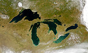
(since four of the five Great Lakes are split between the U.S. and Canada). It is sometimes described as the sixth Great Lake. Lying 260 metres (853 ft) above sea level, the lake drains into the Nipigon River
Nipigon River
The Nipigon River is about long and 50 to 200 m wide in Ontario, Canada. The river drains Lake Nipigon into Nipigon Bay in Lake Superior, dropping from an elevation of 260 m to 183 m .-History:...
and thence into Nipigon Bay of Lake Superior
Lake Superior
Lake Superior is the largest of the five traditionally-demarcated Great Lakes of North America. It is bounded to the north by the Canadian province of Ontario and the U.S. state of Minnesota, and to the south by the U.S. states of Wisconsin and Michigan. It is the largest freshwater lake in the...
. The lake and river are the largest tributaries of Lake Superior. It lies about 120 kilometres (74.6 mi) northeast of the city of Thunder Bay
Thunder Bay
-In Canada:Thunder Bay is the name of three places in the province of Ontario, Canada along Lake Superior:*Thunder Bay District, Ontario, a district in Northwestern Ontario*Thunder Bay, a city in Thunder Bay District*Thunder Bay, Unorganized, Ontario...
, Ontario
Ontario
Ontario is a province of Canada, located in east-central Canada. It is Canada's most populous province and second largest in total area. It is home to the nation's most populous city, Toronto, and the nation's capital, Ottawa....
.
Lake Nipigon has a total area (including islands within the lake) of 4848 square kilometres (1,871.8 sq mi) — compared to 3150 square kilometres (1,216.2 sq mi) for Lake of the Woods
Lake of the Woods
Lake of the Woods is a lake occupying parts of the Canadian provinces of Ontario and Manitoba and the U.S. state of Minnesota. It separates a small land area of Minnesota from the rest of the United States. The Northwest Angle and the town of Angle Township can only be reached from the rest of...
. The largest islands are Caribou Island, Geikie Island, Katatota Island, Kelvin Island, Logan Island, Murchison Island, Murray Island, and Shakespeare Island. Maximum depth is 165 metres (541.3 ft).
The lake is noted for its towering cliffs and unusual green-black sand beaches composed of the fine particles of a dark green mineral known as pyroxene
Pyroxene
The pyroxenes are a group of important rock-forming inosilicate minerals found in many igneous and metamorphic rocks. They share a common structure consisting of single chains of silica tetrahedra and they crystallize in the monoclinic and orthorhombic systems...
. The lake basin provides an important habitat for woodland caribou.
History
As the last Ice AgeIce age
An ice age or, more precisely, glacial age, is a generic geological period of long-term reduction in the temperature of the Earth's surface and atmosphere, resulting in the presence or expansion of continental ice sheets, polar ice sheets and alpine glaciers...
was ending, Lake Nipigon was, at times, part of the drainage path for Lake Agassiz
Lake Agassiz
Lake Agassiz was an immense glacial lake located in the center of North America. Fed by glacial runoff at the end of the last glacial period, its area was larger than all of the modern Great Lakes combined, and it held more water than contained by all lakes in the world today.-Conception:First...
.
The French Jesuit Claude Allouez celebrated the first mass beside the Nipigon River May 29, 1667. He visited the village of the Nipissing Indians who had fled there during the Iroquois onslaught of 1649-50. In the Jesuit Relations the lake is called lac Alimibeg, and was subsequently known as Alemipigon or Alepigon. In the 19th century it was frequently spelled as Lake Nepigon. The may have originated from the Ojibwe language
Ojibwe language
Ojibwe , also called Anishinaabemowin, is an indigenous language of the Algonquian language family. Ojibwe is characterized by a series of dialects that have local names and frequently local writing systems...
Animbiigoong, meaning 'at continuous water' or 'at waters that extends [over the horizon].' Though some sources claim the name may also be translated as 'deep, clear water,' this description is for Lake Temagami
Lake Temagami
Lake Temagami, formerly spelt as Lake Timagami, is a lake in Nipissing District in northeastern Ontario, Canada, situated approximately 80 km north of North Bay...
. Today, the Ojibwa bands call Lake Nipigon Animbiigoo-zaaga'igan.
The 1778 Il Paese de' Selvaggi Outauacesi, e Kilistinesi Intorno al Lago Superiore map by John Mitchell identifies the lake as Lago Nepigon and its outlet as F. Nempissaki. In the 1807 map A New Map of Upper & Lower Canada by John Cary, the lake was called Lake St Ann or Winnimpig, while the outflowing river as Red Stone R. Today, the Red Rock First Nation located along the Nipigon River still bears the "Red Stone" name. In the 1827 map Partie de la Nouvelle Bretagne. by Philippe Vandermaelen, the lake was called L. Ste Anne, while the outflowing river as R. Nipigeon. In the 1832 map North America sheet IV. Lake Superior. by the Society for the Diffusion of Useful Knowledge, the lake was called St Ann or Red L., while the outflowing river as Neepigeon and the heights near the outlet of the Gull River as Neepigon Ho. By 1883, maps such as Statistical & General Map of Canada by Letts, Son & Co., consistently began identify the lake as Lake Nipigon.
In 1683 Daniel Greysolon, Sieur du Lhut
Daniel Greysolon, Sieur du Lhut
Daniel Greysolon, Sieur du Lhut was a French soldier and explorer who is the first European known to have visited the area where the city of Duluth, Minnesota is now located and the headwaters of the Mississippi River near Grand Rapids...
established a fur trading post on Lake Nipigon named Fort Tourette after his brother, Claude Greysolon, Sieur de la Tourette. The Alexis Hubert Jaillot map of 1685 (Partie de la Nouvelle-France) suggests that this fort was somewhere in Ombabika Bay at the northeast end of the lake where the Ombabika River and Little Jackfish River (Kabasakkandagaming) empty. (A copy of this map may be viewed at
Brock University Map Library) The post remained active to the end of the French regime as part of the pays d'en haut.
On 17 April 1744, the Count de Maurepas, Minister of the Marine, informed the Canadian officials that Jean de La Porte
Arnaud I de La Porte
Arnaud I de Laporte -Early life and career:According to Laffilard, archivist of the Marine, as the French Navy was known, Arnaud de La Porte was born around 1706, near Bayonne,...
was to be given the "fur ferme" (i.e. the profits) of Lac Alemipigon from that year forward as a reward for his services in New France.
After the Treaty of Paris (1763)
Treaty of Paris (1763)
The Treaty of Paris, often called the Peace of Paris, or the Treaty of 1763, was signed on 10 February 1763, by the kingdoms of Great Britain, France and Spain, with Portugal in agreement. It ended the French and Indian War/Seven Years' War...
, the area passed into the hands of the British, and the Hudson's Bay Company
Hudson's Bay Company
The Hudson's Bay Company , abbreviated HBC, or "The Bay" is the oldest commercial corporation in North America and one of the oldest in the world. A fur trading business for much of its existence, today Hudson's Bay Company owns and operates retail stores throughout Canada...
expanded its trading area to include the Lake. Although it was considered to be within British North America
British North America
British North America is a historical term. It consisted of the colonies and territories of the British Empire in continental North America after the end of the American Revolutionary War and the recognition of American independence in 1783.At the start of the Revolutionary War in 1775 the British...
, it was not until 1850 that the watershed draining into Lake Superior was ceded formally by the Ojibwe Indians to the Province of Canada
Province of Canada
The Province of Canada, United Province of Canada, or the United Canadas was a British colony in North America from 1841 to 1867. Its formation reflected recommendations made by John Lambton, 1st Earl of Durham in the Report on the Affairs of British North America following the Rebellions of...
(see Robinson Treaty
Robinson Treaty
Robinson Treaty may refer to one of three treaties signed between the Ojibwa chiefs and The Crown.-Lake Superior:The Robinson Treaty for the Lake Superior region, commonly called Robinson Superior Treaty, was entered into agreement on September 7, 1850, at Sault Ste...
, 1850, also known as the Robinson Superior Treaty). A four square mile reservation was set aside on Gull River near Lake Nipigon on both sides of the river for the Chief Mishe-muckqua (from Mishi-makwa, "Great Bear"). In 1871 Lake Nipigon was included in the new Thunder Bay District, Ontario
Thunder Bay District, Ontario
Thunder Bay District is a district and census division in Northwestern Ontario in the Canadian province of Ontario. The district seat is Thunder Bay....
.
The Township of Nipigon was incorporated in 1908. The Municipality of Greenstone
Greenstone, Ontario
Greenstone is an amalgamated town in the Canadian province of Ontario. The area of the town is , stretching along Highway 11 from Lake Nipigon to Longlac; it is one of the largest incorporated towns in Canada....
(pop 5662) was incorporated in 2001 and includes Orient Bay, MacDiarmid, Beardmore, Nakina, Longlac, Caramat, Jellicoe and Geraldton.
In 1943 Canada and the United States agreed to the Ogoki diversion which diverts water into Lake Superior that would normally flow into James Bay
James Bay
James Bay is a large body of water on the southern end of Hudson Bay in Canada. Both bodies of water extend from the Arctic Ocean. James Bay borders the provinces of Quebec and Ontario; islands within the bay are part of Nunavut...
and thence into Hudson Bay
Hudson Bay
Hudson Bay , sometimes called Hudson's Bay, is a large body of saltwater in northeastern Canada. It drains a very large area, about , that includes parts of Ontario, Quebec, Saskatchewan, Alberta, most of Manitoba, southeastern Nunavut, as well as parts of North Dakota, South Dakota, Minnesota,...
. The diversion connects the upper portion of the Ogoki River to Lake Nipigon. This water was diverted to support three hydroelectric plants on the Nipigon River
Nipigon River
The Nipigon River is about long and 50 to 200 m wide in Ontario, Canada. The river drains Lake Nipigon into Nipigon Bay in Lake Superior, dropping from an elevation of 260 m to 183 m .-History:...
. The diversion is governed by the International Lake Superior Board of Control which was established in 1914 by the International Joint Commission
International Joint Commission
The International Joint Commission is an independent binational organization established by the United States and Canada under the Boundary Waters Treaty of 1909.The Commission has responsibilities related to the following treaties and agreements:...
.
Lake Nipigon Provincial Park is located on the east side of Lake Nipigon. In 1999 the park boundary was amended to reduce the park area from 14.58 to 9.18 square kilometres (3,603 to 2,268 acre
Acre
The acre is a unit of area in a number of different systems, including the imperial and U.S. customary systems. The most commonly used acres today are the international acre and, in the United States, the survey acre. The most common use of the acre is to measure tracts of land.The acre is related...
s). The area was deregulated and transferred to the Government of Canada for a reserve for the Sand Point First Nation.
- Douglas, R., ed. Nipigon to Winnipeg : a canoe voyage through Western Ontario by Edward UmfrevilleEdward UmfrevilleEdward Umfreville came to Canada in 1771 to work as a writer for the Hudson's Bay Company. He came to York Factory and almost immediately was transferred to Fort Severn. There, he and Andrew Graham designed a comprehensive plan listing long term requirements for the inland posts that the company...
in 1784, with extracts from the writings of other early travellers through the region. Ottawa : Commercial Printing, 1929.
Geography
Mafic
Mafic is an adjective describing a silicate mineral or rock that is rich in magnesium and iron; the term is a portmanteau of the words "magnesium" and "ferric". Most mafic minerals are dark in color and the relative density is greater than 3. Common rock-forming mafic minerals include olivine,...
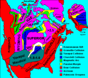
rocks at Lake Nipigon give evidence of rift
Rift
In geology, a rift or chasm is a place where the Earth's crust and lithosphere are being pulled apart and is an example of extensional tectonics....
-related continental basalt
Basalt
Basalt is a common extrusive volcanic rock. It is usually grey to black and fine-grained due to rapid cooling of lava at the surface of a planet. It may be porphyritic containing larger crystals in a fine matrix, or vesicular, or frothy scoria. Unweathered basalt is black or grey...
ic magmatism during the Midcontinent Rift System
Midcontinent Rift System
The Midcontinent Rift System or Keweenawan Rift is a long geological rift in the center of the North American continent and south-central part of the North American plate. It formed when the continent's core, the North American craton, began to split apart during the Mesoproterozoic era of the...
event 1,109 million years ago. Great sill
Sill (geology)
In geology, a sill is a tabular sheet intrusion that has intruded between older layers of sedimentary rock, beds of volcanic lava or tuff, or even along the direction of foliation in metamorphic rock. The term sill is synonymous with concordant intrusive sheet...
s up to 150 to 200 m (492.1 to 656.2 ft) thick are also related with the rifting event, forming cliff
Cliff
In geography and geology, a cliff is a significant vertical, or near vertical, rock exposure. Cliffs are formed as erosion landforms due to the processes of erosion and weathering that produce them. Cliffs are common on coasts, in mountainous areas, escarpments and along rivers. Cliffs are usually...
s hundreds of meters high. The mafic and ultramafic intrusion
Intrusion
An intrusion is liquid rock that forms under Earth's surface. Magma from under the surface is slowly pushed up from deep within the earth into any cracks or spaces it can find, sometimes pushing existing country rock out of the way, a process that can take millions of years. As the rock slowly...
s centered on Lake Nipigon represent a failed arm
Aulacogen
In geology, an aulacogen is a failed arm of a triple junction of a plate tectonics rift system. A triple junction beneath a continental plate initiates a three way breakup of the continental plate. As the continental break-up develops one of the three spreading ridges typically fails or stops...
of the main rift called the Nipigon Embayment
Nipigon Embayment
The Nipigon Embayment is an inactive continental rift zone in Northwestern Ontario, Canada, centered on Lake Nipigon. It represents an aulacogen of the much larger Midcontinent Rift System, which formed some 1,100 million years ago when the North American craton began to split apart during the...
.
Transportation
The main line of the Canadian National RailwayCanadian National Railway
The Canadian National Railway Company is a Canadian Class I railway headquartered in Montreal, Quebec. CN's slogan is "North America's Railroad"....
runs to the north of the lake. Another branch of the CNR touches the southeastern section of the lake at Orient Bay and Macdiarmid before heading inland to Beardmore. Provincial highway 11 also skirts the southeastern section of the lake.
First Nations
The aboriginal population (primarily Ojibwe) include the Animbiigoo Zaagi'igan Anishinaabek (Lake Nipigon Ojibway) First Nation, the Biinjitiwabik Zaaging (Rocky Bay) Anishinaabek First NationBiinjitiwabik Zaaging Anishnabek First Nation
The Biinjitiwaabik Zaaging Anishinaabek is an Ojibway First Nation in Northwestern Ontario, Canada. Their territory is located on the Rocky Bay 1 Indian reserve in Greenstone, Ontario, near Macdiarmid...
, the Bingwi Neyaashi (Sand Point) Anishinaabek First Nation
Bingwi Neyaashi Anishinaabek First Nation
The Bingwi Neyaashi Anishinaabek is an Ojibwa First Nation in Northwestern Ontario, Canada....
, the Red Rock (Lake Helen) First Nation and the Gull Bay First Nation
Gull Bay First Nation
Gull Bay First Nation or Kiashke Zaaging Anishinaabek is an Anishinaabe First Nation located in Thunder Bay District in northwestern Ontario, Canada. It is approximately north of Thunder Bay, Ontario on Highway 527 on the south western shore of Lake Nipigon...
. Formerly, the Whitesand First Nation
Whitesand First Nation
The Whitesand First Nation is an Ojibwa First Nation in Northern Ontario. They have reserved for themselves the Whitesand reserve. The community of Armstrong Settlement is their main community, located coterminously with Armstrong, Thunder Bay District, Ontario...
was also located along the northwestern shores of Lake Nipigon until they were relocated in 1942. The membership of these six First Nations total about 5,000. Along Lake Nipigon, there are three Indian Reserve
Indian reserve
In Canada, an Indian reserve is specified by the Indian Act as a "tract of land, the legal title to which is vested in Her Majesty, that has been set apart by Her Majesty for the use and benefit of a band." The Act also specifies that land reserved for the use and benefit of a band which is not...
s currently not occupied by the aforementioned First Nations: McIntyre Bay IR 54 (shared by four First Nations), Jackfish Island IR 57 (in claims by the Gull Bay First Nation) and Red Rock (Parmachene) IR 53 (under the jursdiction of the Red Rock First Nation).
The first nations CBC TV series Spirit Bay
Spirit Bay
Spirit Bay was an aboriginal family television show of 14 half-hour episodes that aired on CBC and TV Ontario from 1980 to 1986. The show focuses on the lives of townsfolk on an Ojibwe reservation town in MacDiarmid, Ontario. Here, the residents have adapted to white society while retaining...
was filmed on the lake at the Biinjitiwabik Zaaging Anishnabek First Nation
Biinjitiwabik Zaaging Anishnabek First Nation
The Biinjitiwaabik Zaaging Anishinaabek is an Ojibway First Nation in Northwestern Ontario, Canada. Their territory is located on the Rocky Bay 1 Indian reserve in Greenstone, Ontario, near Macdiarmid...
Reserve in the mid-1980s.