
Coppermine River
Encyclopedia
North Slave Region
The North Slave Region is one of five administrative regions in the Northwest Territories. The region consists of eight communities with the regional offices situated in Behchoko and Yellowknife. With the exception of Yellowknife the communities are predominately First Nations.-Communities:The...
and Kitikmeot
Kitikmeot Region, Nunavut
Kitikmeot Region is an administrative region of Nunavut, Canada. It consists of the southern and eastern parts of Victoria Island with the adjacent part of the mainland as far as the Boothia Peninsula, together with King William Island and the southern portion of Prince of Wales Island...
regions of the Northwest Territories
Northwest Territories
The Northwest Territories is a federal territory of Canada.Located in northern Canada, the territory borders Canada's two other territories, Yukon to the west and Nunavut to the east, and three provinces: British Columbia to the southwest, and Alberta and Saskatchewan to the south...
and Nunavut
Nunavut
Nunavut is the largest and newest federal territory of Canada; it was separated officially from the Northwest Territories on April 1, 1999, via the Nunavut Act and the Nunavut Land Claims Agreement Act, though the actual boundaries had been established in 1993...
in Canada
Canada
Canada is a North American country consisting of ten provinces and three territories. Located in the northern part of the continent, it extends from the Atlantic Ocean in the east to the Pacific Ocean in the west, and northward into the Arctic Ocean...
. It is 845 kilometres (525.1 mi) long. It rises in Lac de Gras
Lac de Gras
Lac de Gras is a lake approximately 300 km north of Yellowknife, Northwest Territories, Canada. Lac de Gras was the centre of the Canadian diamond rush of the 1990s. There are two working diamond mines in the area, Ekati Diamond Mine, and Diavik Diamond Mine.It was called Ekati by aboriginal...
, a small lake near Great Slave Lake
Great Slave Lake
Great Slave Lake is the second-largest lake in the Northwest Territories of Canada , the deepest lake in North America at , and the ninth-largest lake in the world. It is long and wide. It covers an area of in the southern part of the territory. Its given volume ranges from to and up to ...
and flows generally north to Coronation Gulf
Coronation Gulf
Coronation Gulf lies between Victoria Island and mainland Nunavut in Canada. To the northwest it connects with Dolphin and Union Strait and thence the Beaufort Sea and Arctic Ocean; to the northeast it connects with Dease Strait and thence Queen Maud Gulf. To the southeast lies Bathurst...
, an arm of the Arctic Ocean
Arctic Ocean
The Arctic Ocean, located in the Northern Hemisphere and mostly in the Arctic north polar region, is the smallest and shallowest of the world's five major oceanic divisions...
. The river freezes in winter but may still flow under the ice.
The community of Kugluktuk
Kugluktuk, Nunavut
Kugluktuk is a hamlet located at the mouth of the Coppermine River in the Kitikmeot Region of Nunavut, Canada, on Coronation Gulf, southwest of Victoria Island...
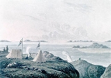
(formerly Coppermine) is located at the river's mouth.
The river was named for the copper
Copper
Copper is a chemical element with the symbol Cu and atomic number 29. It is a ductile metal with very high thermal and electrical conductivity. Pure copper is soft and malleable; an exposed surface has a reddish-orange tarnish...
ores which could be found along the lower river. Samuel Hearne
Samuel Hearne
Samuel Hearne was a an English explorer, fur-trader, author, and naturalist. He was the first European to make an overland excursion across northern Canada to the Arctic Ocean, actually Coronation Gulf, via the Coppermine River...
, travelled down the river to the Arctic Ocean in 1771. Sir John Franklin
John Franklin
Rear-Admiral Sir John Franklin KCH FRGS RN was a British Royal Navy officer and Arctic explorer. Franklin also served as governor of Tasmania for several years. In his last expedition, he disappeared while attempting to chart and navigate a section of the Northwest Passage in the Canadian Arctic...
also travelled down the river during the Coppermine Expedition of 1819–1822
Coppermine Expedition of 1819–1822
The Coppermine Expedition of 1819–1822 had as its goal the exploration of the northern coast of Canada, which was accessed by way of the Coppermine River. The British expedition was organised by the Royal Navy as part of its attempt to discover and map the Northwest Passage...
.
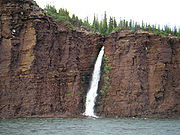
Bloody Falls
Bloody Falls is a waterfall in the Kugluk/Bloody Falls Territorial Park and is the site of the Bloody Falls Massacre and the murder of two priests by Copper Inuit Uloqsaq and Sinnisiak in 1913...
, part of the Kugluk/Bloody Falls Territorial Park
Kugluk/Bloody Falls Territorial Park
Kugluk/Bloody Falls Territorial Park is located about southwest of Kugluktuk, Nunavut, Canada. The park is situated around the Bloody Falls on the Coppermine River and was listed as a national historic site in 1978.The park is probably best known as the site of the Bloody Falls Massacre that...
, is located 18.5 kilometres (11.5 mi) from Kugluktuk
Kugluktuk, Nunavut
Kugluktuk is a hamlet located at the mouth of the Coppermine River in the Kitikmeot Region of Nunavut, Canada, on Coronation Gulf, southwest of Victoria Island...
, and was home to the Kogluktogmiut
Kogluktogmiut
Kogluktogmiut were a geographically defined Copper Inuit subgroup in the Canadian territory of Nunavut. They were located by Bloody Falls , a waterfall on the lower course of the Coppermine River in the Kugluk/Bloody Falls Territorial Park, notable for the Bloody Falls...
a sub-group of the Copper Inuit
Copper Inuit
Copper Inuit are a Canadian Inuit group who live north of the tree line, in Nunavut's Kitikmeot Region and the Northwest Territories's Inuvik Region. Most historically lived in the area around Coronation Gulf, on Victoria Island, and southern Banks Island.Their western boundary was Wise Point,...
. It is the site of the Bloody Falls Massacre
Bloody Falls Massacre
The Massacre at Bloody Falls was an incident that took place during Samuel Hearne's exploration of the Coppermine River on 17 July 1771. Chipewyan and "Copper Indian" Dene men led by Hearne's guide and companion Matonabbee attacked a group of Copper Inuit camped by rapids approximately upstream...
, when Matonabbee
Matonabbee
Matonabbee was a Chipewyan hunter and leader. He traveled with Chief Akaitcho's older brother, Keskarrah. After his father died, Matonabbee spent some time living at Fort Prince of Wales where he learned to speak English....
, Samuel Hearne's guide, and his fellow Chipewyan
Chipewyan
The Chipewyan are a Dene Aboriginal people in Canada, whose ancestors were the Taltheilei...
warriors ambushed and massacred the local Inuit
Inuit
The Inuit are a group of culturally similar indigenous peoples inhabiting the Arctic regions of Canada , Denmark , Russia and the United States . Inuit means “the people” in the Inuktitut language...
.
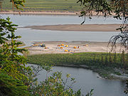
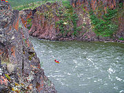
The river is used for wilderness canoe
Canoe
A canoe or Canadian canoe is a small narrow boat, typically human-powered, though it may also be powered by sails or small electric or gas motors. Canoes are usually pointed at both bow and stern and are normally open on top, but can be decked over A canoe (North American English) or Canadian...
ing and rafting, although it sees only a few groups each year. It features major rapids, such as Rocky Defile, Sandstone, Muskox, and Escape Rapids, as well as many unnamed smaller sets. Bloody Falls is the final major rapid of the river, and should be portage
Portage
Portage or portaging refers to the practice of carrying watercraft or cargo over land to avoid river obstacles, or between two bodies of water. A place where this carrying occurs is also called a portage; a person doing the carrying is called a porter.The English word portage is derived from the...
d.
The Coppermine River is the namesake of Coppermine Herald
Coppermine Herald
Coppermine Herald of Arms is the title of one of the officers of arms at the Canadian Heraldic Authority in Ottawa. The office was created in 2003 and Coppermine Herald is the assistant artist of the Authority. Like the other heralds at the Authority, the name is derived from the Canadian river....
at the Canadian Heraldic Authority
Canadian Heraldic Authority
The Canadian Heraldic Authority is part of the Canadian honours system under the Queen of Canada, whose authority is exercised by the Governor General. The Authority is responsible for the creation and granting of new coats of arms , flags and badges for Canadian citizens, permanent residents and...
.
Geology of the region
Eruption of plateauPlateau
In geology and earth science, a plateau , also called a high plain or tableland, is an area of highland, usually consisting of relatively flat terrain. A highly eroded plateau is called a dissected plateau...
lava
Lava
Lava refers both to molten rock expelled by a volcano during an eruption and the resulting rock after solidification and cooling. This molten rock is formed in the interior of some planets, including Earth, and some of their satellites. When first erupted from a volcanic vent, lava is a liquid at...
s near the Coppermine River, built an extensive volcanic plateau
Volcanic plateau
A volcanic plateau is a plateau produced by volcanic activity. There are two main types: lava plateaus and pyroclastic plateaus.-Lava plateau:...
about 1,200 million years ago with an area of about 170000 square kilometres (65,637.4 sq mi) representing a volume of lavas of at least 500000 cubic kilometres (119,956.4 cu mi). These lavas were formed during the same time as the large Muskox intrusion
Muskox intrusion
The Muskox intrusion is a layered intrusion in Nunavut, Canada. It is located northeast of Great Bear Lake and south of Kugluktuk on Coronation Gulf...
and the extensive Mackenzie dike swarm
Mackenzie dike swarm
The Mackenzie dike swarm, also called the Mackenzie dikes, form a large igneous province in the western Canadian Shield of Canada. It is part of the larger Mackenzie Large Igneous Province and is one of more than three dozen dike swarms in various parts of the Canadian Shield...
to the southeast. The lavas are thought to have originated from a mantle plume
Mantle plume
A mantle plume is a hypothetical thermal diapir of abnormally hot rock that nucleates at the core-mantle boundary and rises through the Earth's mantle. Such plumes were invoked in 1971 to explain volcanic regions that were not thought to be explicable by the then-new theory of plate tectonics. Some...
center called the Mackenzie hotspot
Mackenzie hotspot
The Mackenzie hotspot was a volcanic hotspot that existed about 1,267 million years ago across Canada from the Northwest Territories and Nunavut. It is responsible for the creation of the Mackenzie Large Igneous Province, which contains the largest dike swarm on Earth...
.
See also
- List of longest rivers of Canada
- List of rivers of the Northwest Territories
- List of rivers of Nunavut