
Tuya Butte
Encyclopedia
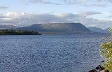
Tuya Butte is a tuya
in the Tuya Range
of north-central British Columbia
, Canada
. It is a bit less isolated from other ranges than neighbouring Mount Josephine
. Some of the other volcanoes in the area include South Tuya
, Ash Mountain
, and Mathews Tuya
.
Tuya Butte was the first tuya analyzed in the geological literature, and its name has since become standard worldwide among volcanologist
s in referring to and writing about tuyas. The Tuya Mountains Provincial Park
was recently established to protect this unusual landscape, which lies north of Tuya Lake
and south of the Jennings River
near the boundary with the Yukon Territory. Tuya Butte is regarded as among the best examples of this landform outside Iceland
and Antarctica.
Tuya Butte was named by Canadian volcanologist
Bill Mathews
in association with adjacent Tuya Lake and Butte Lake. The term tuya may be derived from a Tahltan
word.
, a volcanic field
that includes tuyas, postglacial lapilli
cones and lava flows and several small shield volcano
es formed during the Pleistocene
and Holocene
. This in turn is part of the Northern Cordilleran Volcanic Province
from Prince Rupert
, into the Yukon
and the Alaska
border caused by rift
ing of the North American Plate
as the Pacific Plate
slides northward along the Queen Charlotte Fault
.
Tuya Butte formed when magma
intruded into and melted a vertical pipe in the overlying Cordilleran Ice Sheet
. The partially molten mass cooled as a large block, forming the highly developed hyaloclastite
and pillow lava
with gravity flattening its upper surface. Horizontal columns occur at numerous locations along the periphery of the mass. The absence of glacial erosion of the tuya suggests that it erupted during the Pleistocene
. The volcano has no summit crater or obvious vent, suggesting the volcano was fed by a fissure
, although several indictions suggest a vent location near a large cirque on the north face. Other subglacial volcano
es can be found in the Wells Gray-Clearwater volcanic field
and the Garibaldi Volcanic Belt
.
Tuya
A tuya is a type of distinctive, flat-topped, steep-sided volcano formed when lava erupts through a thick glacier or ice sheet. They are somewhat rare worldwide, being confined to regions which were covered by glaciers and also had active volcanism during the same time period.-Formation:Tuyas are...
in the Tuya Range
Tuya Range
The Tuya Range is a range of tuyas, located in the Stikine Ranges of the Cassiar Mountains in the far northr of the Canadian province of British Columbia, near its border with the Yukon Territory and to the southwest of Watson Lake, Yukon, which is the nearest major settlement.-Boundaries and...
of north-central British Columbia
British Columbia
British Columbia is the westernmost of Canada's provinces and is known for its natural beauty, as reflected in its Latin motto, Splendor sine occasu . Its name was chosen by Queen Victoria in 1858...
, Canada
Canada
Canada is a North American country consisting of ten provinces and three territories. Located in the northern part of the continent, it extends from the Atlantic Ocean in the east to the Pacific Ocean in the west, and northward into the Arctic Ocean...
. It is a bit less isolated from other ranges than neighbouring Mount Josephine
Mount Josephine (British Columbia)
Mount Josephine is a subglacial mound in the Tuya Range in British Columbia, Canada. It is located near the northwestern shore of Tuya Lake.-See also:* Northern Cordilleran Volcanic Province* Tuya Range* List of Northern Cordilleran volcanoes...
. Some of the other volcanoes in the area include South Tuya
South Tuya
South Tuya, also called Southern Tuya, is a tuya clustered around Tuya Lake in the Northern Cordilleran Volcanic Province in British Columbia, Canada...
, Ash Mountain
Ash Mountain (British Columbia)
Ash Mountain is the highest summit in the Tuya Range of the Stikine Ranges in northcentral British Columbia, Canada, located immediately north of High Tuya Lake at the north end of Tuya Mountains Provincial Park. It is one of the six tuyas clustered close to Tuya Lake...
, and Mathews Tuya
Mathews Tuya
Mathews Tuya is a subglacial mound in northcentral British Columbia. It is one of the six tuyas close to Tuya Lake. It has been partly glaciated so it is probably older than 10,000 years. The other volcanoes in the area include Tuya Butte, South Tuya and Ash Mountain...
.
Tuya Butte was the first tuya analyzed in the geological literature, and its name has since become standard worldwide among volcanologist
Volcanologist
A volcanologist is a person who studies the formation of volcanoes, and their current and historic eruptions. Volcanologists frequently visit volcanoes, especially active ones, to observe volcanic eruptions, collect eruptive products including tephra , rock and lava samples...
s in referring to and writing about tuyas. The Tuya Mountains Provincial Park
Tuya Mountains Provincial Park
Tuya Mountains Provincial Park is a provincial park in British Columbia, Canada, protecting the Tuya Range, a volcanic region at the head of the Tuya River. The park is located on the north side of Tuya Lake. The park is named for nearby Tuyas, steep-sided, flat-topped types of volcano....
was recently established to protect this unusual landscape, which lies north of Tuya Lake
Tuya Lake
Tuya Lake, located in northwestern British Columbia, Canada, presumably derives its name from the presence of nearby steep-sided, flat-topped volcanoes, known as tuyas...
and south of the Jennings River
Jennings River
The Jennings River is a river in far northern British Columbia, Canada, rising in the northern reaches of the Stikine Ranges of the Cassiar Mountains, at first running southwest, then turning northeast near the Tuya Range to enter Teslin Lake at its southern end, just to the east of the estuary of...
near the boundary with the Yukon Territory. Tuya Butte is regarded as among the best examples of this landform outside Iceland
Iceland
Iceland , described as the Republic of Iceland, is a Nordic and European island country in the North Atlantic Ocean, on the Mid-Atlantic Ridge. Iceland also refers to the main island of the country, which contains almost all the population and almost all the land area. The country has a population...
and Antarctica.
Tuya Butte was named by Canadian volcanologist
Volcanology
Volcanology is the study of volcanoes, lava, magma, and related geological, geophysical and geochemical phenomena. The term volcanology is derived from the Latin word vulcan. Vulcan was the ancient Roman god of fire....
Bill Mathews
Bill Mathews
William Henry Mathews was a Canadian geologist, volcanologist, engineer, and professor. He is considered a pioneer in the study of subglacial eruptions and volcano-ice interactions in North America...
in association with adjacent Tuya Lake and Butte Lake. The term tuya may be derived from a Tahltan
Tahltan
Tahltan refers to a Northern Athabaskan people who live in northern British Columbia around Telegraph Creek, Dease Lake, and Iskut.-Social Organization:...
word.
Geology
Tuya Butte is part of the Tuya Volcanic FieldTuya Volcanic Field
The Tuya volcanic field is a volcanic field of tuyas located in far northern British Columbia, Canada, near the border with the Yukon Territory and focussed on the area of the Tuya Range, a subrange of the Stikine Ranges of the Cassiar Mountains, though some vents are in the Kawdy Plateau, the...
, a volcanic field
Volcanic field
A volcanic field is an area of the Earth's crust that is prone to localized volcanic activity. They usually contain 10 to 100 volcanoes, such as cinder cones and are usually in clusters. Lava flows may also occur...
that includes tuyas, postglacial lapilli
Lapilli
Lapilli is a size classification term for tephra, which is material that falls out of the air during a volcanic eruption or during some meteorite impacts. Lapilli means "little stones" in Latin. They are in some senses similar to ooids or pisoids in calcareous sediments.By definition lapilli range...
cones and lava flows and several small shield volcano
Shield volcano
A shield volcano is a type of volcano usually built almost entirely of fluid lava flows. They are named for their large size and low profile, resembling a warrior's shield. This is caused by the highly fluid lava they erupt, which travels farther than lava erupted from more explosive volcanoes...
es formed during the Pleistocene
Pleistocene
The Pleistocene is the epoch from 2,588,000 to 11,700 years BP that spans the world's recent period of repeated glaciations. The name pleistocene is derived from the Greek and ....
and Holocene
Holocene
The Holocene is a geological epoch which began at the end of the Pleistocene and continues to the present. The Holocene is part of the Quaternary period. Its name comes from the Greek words and , meaning "entirely recent"...
. This in turn is part of the Northern Cordilleran Volcanic Province
Northern Cordilleran volcanic province
The Northern Cordilleran Volcanic Province , formerly known as the Stikine Volcanic Belt, is a geologic province defined by the occurrence of Miocene to Holocene volcanoes in the Pacific Northwest of North America...
from Prince Rupert
Prince Rupert, British Columbia
Prince Rupert is a port city in the province of British Columbia, Canada. It is the land, air, and water transportation hub of British Columbia's North Coast, and home to some 12,815 people .-History:...
, into the Yukon
Yukon
Yukon is the westernmost and smallest of Canada's three federal territories. It was named after the Yukon River. The word Yukon means "Great River" in Gwich’in....
and the Alaska
Alaska
Alaska is the largest state in the United States by area. It is situated in the northwest extremity of the North American continent, with Canada to the east, the Arctic Ocean to the north, and the Pacific Ocean to the west and south, with Russia further west across the Bering Strait...
border caused by rift
Rift
In geology, a rift or chasm is a place where the Earth's crust and lithosphere are being pulled apart and is an example of extensional tectonics....
ing of the North American Plate
North American Plate
The North American Plate is a tectonic plate covering most of North America, Greenland, Cuba, Bahamas, and parts of Siberia, Japan and Iceland. It extends eastward to the Mid-Atlantic Ridge and westward to the Chersky Range in eastern Siberia. The plate includes both continental and oceanic crust...
as the Pacific Plate
Pacific Plate
The Pacific Plate is an oceanic tectonic plate that lies beneath the Pacific Ocean. At 103 million square kilometres, it is the largest tectonic plate....
slides northward along the Queen Charlotte Fault
Queen Charlotte Fault
The Queen Charlotte Fault is an active transform fault, located between the North American Plate and the Pacific Plate, Canada's equivalent of the San Andreas Fault. The Queen Charlotte Fault forms a triple junction on its south with the Cascadia subduction zone and the Explorer Ridge...
.
Tuya Butte formed when magma
Magma
Magma is a mixture of molten rock, volatiles and solids that is found beneath the surface of the Earth, and is expected to exist on other terrestrial planets. Besides molten rock, magma may also contain suspended crystals and dissolved gas and sometimes also gas bubbles. Magma often collects in...
intruded into and melted a vertical pipe in the overlying Cordilleran Ice Sheet
Cordilleran Ice Sheet
The Cordilleran ice sheet was a major ice sheet that covered, during glacial periods of the Quaternary, a large area of North America. This included the following areas:*Western Montana*The Idaho Panhandle...
. The partially molten mass cooled as a large block, forming the highly developed hyaloclastite
Hyaloclastite
Hyaloclastite is a hydrated tuff-like breccia rich in black volcanic glass, formed during volcanic eruptions under water, under ice or where subaerial flows reach the sea or other bodies of water. It has the appearance of angular flat fragments sized between a millimeter to few centimeters...
and pillow lava
Pillow lava
Pillow lavas are lavas that contain characteristic pillow-shaped structures that are attributed to the extrusion of the lava under water, or subaqueous extrusion. Pillow lavas in volcanic rock are characterized by thick sequences of discontinuous pillow-shaped masses, commonly up to one metre in...
with gravity flattening its upper surface. Horizontal columns occur at numerous locations along the periphery of the mass. The absence of glacial erosion of the tuya suggests that it erupted during the Pleistocene
Pleistocene
The Pleistocene is the epoch from 2,588,000 to 11,700 years BP that spans the world's recent period of repeated glaciations. The name pleistocene is derived from the Greek and ....
. The volcano has no summit crater or obvious vent, suggesting the volcano was fed by a fissure
Fissure vent
A fissure vent, also known as a volcanic fissure or simply fissure, is a linear volcanic vent through which lava erupts, usually without any explosive activity. The vent is usually a few meters wide and may be many kilometers long. Fissure vents can cause large flood basalts and lava channels...
, although several indictions suggest a vent location near a large cirque on the north face. Other subglacial volcano
Subglacial volcano
A subglacial volcano, also known as a glaciovolcano, is a volcanic form produced by subglacial eruptions or eruptions beneath the surface of a glacier or ice sheet which is then melted into a lake by the rising lava...
es can be found in the Wells Gray-Clearwater volcanic field
Wells Gray-Clearwater volcanic field
The Wells Gray-Clearwater volcanic field, also called the Clearwater Cone Group, is a potentially active monogenetic volcanic field in east-central British Columbia, Canada, located approximately north of Kamloops. It is situated in the Cariboo Mountains of the Columbia Mountains and on the...
and the Garibaldi Volcanic Belt
Garibaldi Volcanic Belt
The Garibaldi Volcanic Belt, also called the Canadian Cascade Arc, is a northwest-southeast trending volcanic chain in the Pacific Ranges of the Coast Mountains that extends from Watts Point in the south to the Ha-Iltzuk Icefield in the north. This chain of volcanoes is located in southwestern...
.
See also
- List of volcanoes in Canada
- List of Northern Cordilleran volcanoes
- Volcanism of Canada
- Volcanism of Western CanadaVolcanism of Western CanadaVolcanism of Western Canada produces lava flows, lava plateaus, lava domes, cinder cones, stratovolcanoes, shield volcanoes, submarine volcanoes, calderas, diatremes and maars, along with examples of more less common volcanic forms such as tuyas and subglacial mounds.-Volcanic belts:*Anahim...
- Tuya Mountains Provincial ParkTuya Mountains Provincial ParkTuya Mountains Provincial Park is a provincial park in British Columbia, Canada, protecting the Tuya Range, a volcanic region at the head of the Tuya River. The park is located on the north side of Tuya Lake. The park is named for nearby Tuyas, steep-sided, flat-topped types of volcano....