

Slave craton
Encyclopedia
Canada
Canada is a North American country consisting of ten provinces and three territories. Located in the northern part of the continent, it extends from the Atlantic Ocean in the east to the Pacific Ocean in the west, and northward into the Arctic Ocean...
geological formation located in the Northwest Territories
Northwest Territories
The Northwest Territories is a federal territory of Canada.Located in northern Canada, the territory borders Canada's two other territories, Yukon to the west and Nunavut to the east, and three provinces: British Columbia to the southwest, and Alberta and Saskatchewan to the south...
and Nunavut
Nunavut
Nunavut is the largest and newest federal territory of Canada; it was separated officially from the Northwest Territories on April 1, 1999, via the Nunavut Act and the Nunavut Land Claims Agreement Act, though the actual boundaries had been established in 1993...
. This craton
Craton
A craton is an old and stable part of the continental lithosphere. Having often survived cycles of merging and rifting of continents, cratons are generally found in the interiors of tectonic plates. They are characteristically composed of ancient crystalline basement rock, which may be covered by...
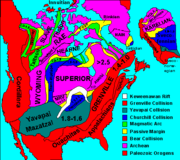
is approximately 300000 square kilometre in size and forms part of the Canadian Shield
Canadian Shield
The Canadian Shield, also called the Laurentian Plateau, or Bouclier Canadien , is a vast geological shield covered by a thin layer of soil that forms the nucleus of the North American or Laurentia craton. It is an area mostly composed of igneous rock which relates to its long volcanic history...
. It is dominated by ca. 2.73-2.63 Ga greenstones
Greenstone belt
Greenstone belts are zones of variably metamorphosed mafic to ultramafic volcanic sequences with associated sedimentary rocks that occur within Archaean and Proterozoic cratons between granite and gneiss bodies....
and turbidite
Turbidite
Turbidite geological formations have their origins in turbidity current deposits, which are deposits from a form of underwater avalanche that are responsible for distributing vast amounts of clastic sediment into the deep ocean.-The ideal turbidite sequence:...
sequences
Sequence (geology)
A sequence in geology refers to a sequence of geological events, processes, or rocks, arranged in chronological order.A rock stratigraphical sequence is a geographical, or lithostratigraphic, discrete unit greater than a group or supergroup rank, and traceable over large areas of a continent...
and ca. 2.72-2.58 Ga plutonic rock, with large parts of the craton underlain by older gneiss
Gneiss
Gneiss is a common and widely distributed type of rock formed by high-grade regional metamorphic processes from pre-existing formations that were originally either igneous or sedimentary rocks.-Etymology:...
and granitoid
Granitoid
A granitoid or granitic rock is a variety of coarse grained plutonic rock similar to granite which mineralogically are composed predominately of feldspar and quartz. Examples of granitoid rocks include granite, quartz monzonite, quartz diorite, syenite, granodiorite and trondhjemite. Many are...
units. The cratonic block extends from the Great Slave Lake
Great Slave Lake
Great Slave Lake is the second-largest lake in the Northwest Territories of Canada , the deepest lake in North America at , and the ninth-largest lake in the world. It is long and wide. It covers an area of in the southern part of the territory. Its given volume ranges from to and up to ...
at about 61 °N to Coronation Gulf
Coronation Gulf
Coronation Gulf lies between Victoria Island and mainland Nunavut in Canada. To the northwest it connects with Dolphin and Union Strait and thence the Beaufort Sea and Arctic Ocean; to the northeast it connects with Dease Strait and thence Queen Maud Gulf. To the southeast lies Bathurst...
on the Arctic Ocean
Arctic Ocean
The Arctic Ocean, located in the Northern Hemisphere and mostly in the Arctic north polar region, is the smallest and shallowest of the world's five major oceanic divisions...
at 69 °N. It covers longitudinally
Longitude
Longitude is a geographic coordinate that specifies the east-west position of a point on the Earth's surface. It is an angular measurement, usually expressed in degrees, minutes and seconds, and denoted by the Greek letter lambda ....
the area between about 105 °W to 117 °W. The Slave includes the Acasta Gneiss
Acasta Gneiss
The Acasta Gneiss is a rock outcrop of Hadean tonalite gneiss in the Slave craton in Northwest Territories, Canada. Located on an island about 300 kilometres north of Yellowknife, the Acasta River rock deposit, believed to be 4.031 to 3.58 billion years old, is the oldest known intact crustal...
which is one of the oldest dated rock units on Earth at 4.03 Ga.
The crust
Crust (geology)
In geology, the crust is the outermost solid shell of a rocky planet or natural satellite, which is chemically distinct from the underlying mantle...
of the Slave craton is thought to have amalgamated during a 2.69 Ga collision between a proto-Slave western basement
Basement Rock
Basement or Basement Rock music was a sub-genre coined in 2006 in an article by music magazine TGR. This was first in relation to the existence of underground record label Criminal Records but more for the independent bands they represent. The roots of the sub-genre are noted to be as far back as...
complex, known as the Central Slave Basement Complex, and an eastern putative island arc
Island arc
An island arc is a type of archipelago composed of a chain of volcanoes which alignment is arc-shaped, and which are situated parallel and close to a boundary between two converging tectonic plates....
terrane
Terrane
A terrane in geology is short-hand term for a tectonostratigraphic terrane, which is a fragment of crustal material formed on, or broken off from, one tectonic plate and accreted or "sutured" to crust lying on another plate...
(Hackett River) along a N-S suture
Suture (geology)
In structural geology, a suture is a major fault zone through an orogen or mountain range. Sutures separate terranes, tectonic units that have different plate tectonic, metamorphic and paleogeographic histories...
. Along the Acasta River, this basement complex yields protolith ages up to ca. 4.03 Ga.
Ages represented by the craton are the Cambrian
Cambrian
The Cambrian is the first geological period of the Paleozoic Era, lasting from Mya ; it is succeeded by the Ordovician. Its subdivisions, and indeed its base, are somewhat in flux. The period was established by Adam Sedgwick, who named it after Cambria, the Latin name for Wales, where Britain's...
, Cretaceous
Cretaceous
The Cretaceous , derived from the Latin "creta" , usually abbreviated K for its German translation Kreide , is a geologic period and system from circa to million years ago. In the geologic timescale, the Cretaceous follows the Jurassic period and is followed by the Paleogene period of the...
, Eocene
Eocene
The Eocene Epoch, lasting from about 56 to 34 million years ago , is a major division of the geologic timescale and the second epoch of the Paleogene Period in the Cenozoic Era. The Eocene spans the time from the end of the Palaeocene Epoch to the beginning of the Oligocene Epoch. The start of the...
, Jurassic
Jurassic
The Jurassic is a geologic period and system that extends from about Mya to Mya, that is, from the end of the Triassic to the beginning of the Cretaceous. The Jurassic constitutes the middle period of the Mesozoic era, also known as the age of reptiles. The start of the period is marked by...
,
Permian
Permian
The PermianThe term "Permian" was introduced into geology in 1841 by Sir Sir R. I. Murchison, president of the Geological Society of London, who identified typical strata in extensive Russian explorations undertaken with Edouard de Verneuil; Murchison asserted in 1841 that he named his "Permian...
and Siluro
Silurian
The Silurian is a geologic period and system that extends from the end of the Ordovician Period, about 443.7 ± 1.5 Mya , to the beginning of the Devonian Period, about 416.0 ± 2.8 Mya . As with other geologic periods, the rock beds that define the period's start and end are well identified, but the...
-Ordovician
Ordovician
The Ordovician is a geologic period and system, the second of six of the Paleozoic Era, and covers the time between 488.3±1.7 to 443.7±1.5 million years ago . It follows the Cambrian Period and is followed by the Silurian Period...
, based on the craton's known kimberlite
Kimberlite
Kimberlite is a type of potassic volcanic rock best known for sometimes containing diamonds. It is named after the town of Kimberley in South Africa, where the discovery of an diamond in 1871 spawned a diamond rush, eventually creating the Big Hole....
s which presently number in the hundreds.
See also
- Mackenzie Large Igneous ProvinceMackenzie Large Igneous ProvinceThe Mackenzie Large Igneous Province is a major Mesoproterozoic large igneous province of the southwestern, western and northwestern Canadian Shield in Canada. It consists of a group of related igneous rocks that were formed during a massive igneous event starting about 1,270 million years ago...
- Canadian ShieldCanadian ShieldThe Canadian Shield, also called the Laurentian Plateau, or Bouclier Canadien , is a vast geological shield covered by a thin layer of soil that forms the nucleus of the North American or Laurentia craton. It is an area mostly composed of igneous rock which relates to its long volcanic history...
- North American craton