

Mount Garibaldi
Encyclopedia
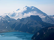
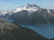
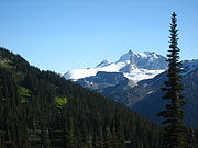
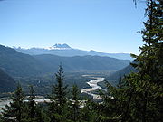
Mount Garibaldi is a potentially active stratovolcano
in the Sea to Sky Country of British Columbia
, 80 km (50 mi) north of Vancouver
, Canada
. Located in the southernmost Coast Mountains
, it is one of the most recognized peaks in the South Coast
region, as well as British Columbia's best known volcano. It lies within the Garibaldi Ranges
of the Pacific Ranges
.
This heavily eroded
dome
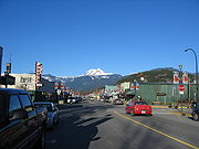
complex occupies the southwest corner of Garibaldi Provincial Park
overlooking the town of Squamish
. It is the only major Pleistocene
age volcano in North America
known to have formed upon a glacier. Although part of the Garibaldi Volcanic Belt
within the Cascade Volcanic Arc, it is not considered part of the Cascade Range
.
of this territory, the mountain is called Nch'kay. In their language it means "Dirty Place" or "Grimy One". This name of the mountain refers to the muddy water in the Cheekye River
. This mountain, like others located in the area, is considered sacred for it plays an important part in their history. In their oral history
, they passed down a story of the flood covering the land. During this time, only two mountains peaked over the water, and this mountain was one of them. It was here that the remaining survivors of the flood latched their canoes to the peak and waited for the waters to subside. The mountain also serves as weather indicator to the people, as when clouds cover the face of the mountain, it signals the coming of rain or snow. Cultural ceremonial use, hunting, trapping and plant gathering occur around the Mount Garibaldi area, but the most important resource was a lithic
material called obsidian
. Obsidian is a black volcanic glass that was used to make knives, chisels, adze
s, and other sharp tools in pre-contact times. This material appears in sites dated to 10,000 years ago up to “protohistoric time periods. The source for this material is found in upper parts of the mountain area in higher elevations that surround the mountain range.
George Vancouver
reached Howe Sound
in June 1792 and became the first European to see the mountain. During this time George Vancouver met and traded with the local natives in the area.
 In 1860, while carrying out a survey of Howe Sound on board the Royal Navy
survey ship HMS Plumper, Captain George Henry Richards
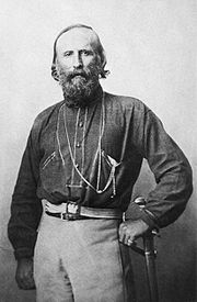
was impressed by a gigantic mountain dominating the view to the northeast. Captain Richards, and his officers, re-named the mountain after the Italian military and political leader Giuseppe Garibaldi
, who that year had succeeded in unifying Italy
by patriating Sicily
and Naples
. In August 1907, the Vancouver
mountaineers A. Dalton, W. Dalton, A. King, T. Pattison, J.J. Trorey, and G. Warren reached the summit of Mount Garibaldi. The views from the peak inspired the establishment of summer climbing camps at Garibaldi Lake
. This early interest led to the creation in 1920 of a park reserve.
In 1927, Garibaldi was made into a large wilderness park called Garibaldi Provincial Park
. Named after Mount Garibaldi, this 1,946.5 square kilometre park was established to protect the rich geological history, diverse vegetation, iridescent waters, abundant wildlife, and rugged mountains, many of which are capped by glaciers.
When skiing caught on in the 1940s, Vancouver skiers began to search the glacier
s and rugged mountains within the park. Early skiing was limited to the more easily reached area around Garibaldi Lake
. In the winter of 1944, a club group completed the first possible ski of Mount Garibaldi. The famous mountaineers Don
and Phyllis Munday
completed lots of tracks additionally. In the 1944-45 Canadian Alpine Journal, the Mundays reported a ski attempt on Mount Garibaldi with Phil Brook, who was a friend of the Mundays. They skied on Sphinx Glacier and scrabbled Panorama Ridge just north of Garibaldi Lake
during the same trip. Most importantly, during this period a road was built on Paul Ridge near the small community of Squamish
at the north end of Howe Sound
, therefore granted better vehicle approach to the highlands near Mount Garibaldi. With easier access Vancouver skiers spent even more time on the glaciers of Mount Garibaldi. The result of this was the formation in the 1940s of the Garibaldi Névé Traverse, an overnight adventure that (weather permitting) can include a fine descent of Mount Garibaldi.
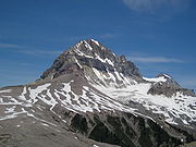
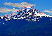
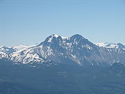
 The broad top of Mount Garibaldi contains three named peaks. The highest peak is named as the mountain itself, reaching 2678 m (8,786 ft) above sea level. The second highest peak is the sharp pyramid of Atwell Peak
at the southern edge of the summit plateau, which reaches a height of 2655 m (8,711 ft) and lies on the southwest end of Garibaldi Provincial Park. This peak is named after Atwell Duncan Francis Joseph King, leader of the first ascent of Mount Garibaldi in 1907. The lowest of the three is the rounded Dalton Dome, 2653 m (8,704 ft) high, west of the highest summit. This peak is named after Arthur Tinniswood Dalton, one of the guides of the 1907 ascent.
A feature on the north side of the mountain, known as The Tent, reaches 2465 m (8,087 ft) and lies in Garibaldi Provincial Park. Another minor summit on the south side of the mountain, 2056 m (6,745 ft) high, is known as Diamond Head (sometimes Little Diamond Head) for its resemblance to Diamond Head
in Hawaii
. Diamond Head was the site of a ski proposal and small lodge, now derelict. On the northwest side of Mount Garibaldi, Brohm Ridge lies outside the western boundary of Garibaldi Provincial Park. The Sharkfin sticks up out of the Warren Glacier on the northeast side of the mountain with a height of 2000 m (6,562 ft), just northeast of Squamish
. Columnar Peak rises on the south side of the mountain with a height of 1826 m (5,991 ft), just southwest of Mamquam Lake at southwest end of Garibaldi Provincial Park. Two pinnacle
s of volcanic rock
5 km (3 mi) south of Mount Garibaldi's summit, which attain heights of 1816 m (5,958 ft) and 1823 m (5,981 ft), have been known as The Gargoyles since 1978.
, the Diamond Glacier
to the southeast and the upper Bishop Glacier to the northeast. Straight north of Atwell toward Mount Garibaldi lies a small, high-elevation ice cap called the Cheekye Glacier, the name of which is associated with Cheekye River
.
A large icefield lies on the eastern and northern flanks of Mount Garibaldi called the Garibaldi Névé
. Its drainage is to the east into the Pitt River
, to the southwest into Garibaldi Lake
. It has an area of 35 km2 and is an area of substantial snowfall with more than 5 m (16 ft) in many winters. The Garibaldi Névé is usually accessed from the south through the Bishop Glacier or from the north through the Sentinel Glacier.
 Mountain climbing
on Mount Garibaldi is fairly difficult; it is fairly steep-sided and involves climbing very loose rotten lava
and volcanic ash
. Fortunately, Mount Garibaldi has large areas of massive glaciation and extensive snowfields. The eastern and northern flanks of the mountain are smothered by the Garibaldi Névé
where the finest climbing opportunities exist, making the easiest route a glacial travel or snow climb. Routes keep mostly to the alpine glacier
s and snow slopes, which are abundant in winter and spring, but eventually melt in late spring and commonly vanish after June or July of most years. After the snow and ice melts, fissures and fractures can pose difficulty and danger, and avalanches from higher peaks of the mountain are a hazard. For this reason, early season, cold-weather ascents are recommended for most routes up Garibaldi.
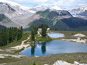
Hiking
, photography
, and camping
are popular in the Garibaldi area. Hiking trails, including the Garibaldi Lake Trail, a 6 km (4 mi) circumnavigation of the peak provide access to the backcountry. Mount Garibaldi is also popular for winter sports, including cross-country skiing. In summer, visitors pass through meadows of wildflowers, on trails emanating from Garibaldi Provincial Park.
 Mount Garibaldi lies within the Coast Plutonic Complex, which is the single largest contiguous granite
outcropping in North America. The intrusive
and metamorphic rock
s extend approximately 1800 km (1,118 mi) along the coast of British Columbia, the Alaska Panhandle
and southwestern Yukon
. This is a remnant of a once vast volcanic arc
called the Coast Range Arc that formed as a result of subduction
of the Farallon
and Kula Plate
s during the Jurassic
-to-Eocene
periods. In contrast, Garibaldi, Meager
, Cayley
and Silverthrone
areas are of recent volcanic origin.
Mount Garibaldi is one of the few Cascade volcanoes that is made exclusively of dacite
(Glacier Peak
is the other). The mountain
has a unique asymmetrical shape because its main cone was constructed atop part of a large glacier
system associated with the Cordilleran Ice Sheet
that has since melted away. Unlike many of the other Cascade volcanoes to the south, Garibaldi does not dominate the surrounding landscape, which consists of many high, rugged peaks. Many residents of Vancouver are therefore not aware that there is a volcano closer to the city than the more easily visible Mount Baker
in Washington State.
 Mount Garibaldi began erupting about 250,000 years ago and has grown steadily since then. Like all of the Cascade volcanoes, Mount Garibaldi has its origins in the Cascadia subduction zone
—a long convergent plate boundary that stretches from mid-Vancouver Island
to Northern California
. The subduction zone separates the Juan de Fuca
, Explorer
, Gorda
and North American Plate
s. Here, the oceanic crust
of the Pacific Ocean
sinks beneath North America
at a rate of 40 millimetres (1.6 in) per year. Hot magma
upwelling above the descending oceanic plate creates volcanoes, and each individual volcano erupts for a few million years.
The subduction zone has existed for at least 37 million years, and has created a line of volcanoes called the Cascade Volcanic Arc which stretches over 1000 km (621 mi) along the subduction zone. Several volcanoes in the arc are potentially active. Lassen Peak
in California, which last erupted in 1917, is the southernmost historically active volcano in the arc, while Mount Meager
, just north of Mount Garibaldi, which erupted about 2,350 years ago, is generally considered the northernmost. A few isolated volcanic centers northwest of Mount Meager, such as the Silverthrone Caldera
, which is a circular 20 km (12 mi) wide, deeply dissected caldera
complex, are considered by some geologists to be the northernmost member of the arc.
 Mount Garibaldi is the largest volcano in southernmost British Columbia. Like other stratovolcano
es, it is composed of many layers of hardened lava, tephra
, and volcanic ash. Eruptions are explosive in nature, and the most common form is the Peléan
style, which involves viscous magma
, glowing avalanches of hot volcanic ash
and pyroclastic flow
s. The source magma of this rock is classified as acid
ic, having high to intermediate levels of silica (as in rhyolite
, dacite
, or andesite
). The tephra deposits have lower volume and range than the corresponding Plinian
and Vulcanian eruption
s.
Mount Garibaldi is known both for the very high quality exposures of its internal structure and for its conspicuous topographic
anomalies, which can be attributed to the growth of the mountain onto a large glacier system and the subsequent collapse of the flanks of the volcano with the melting of the ice. The western flanks of the mountain expose basement rocks, sheared and altered quartz
diorite
, carved by streams and glaciers into a rugged topography with relief up to 1800 m (5,906 ft). Valleys in this jagged surface have been filled with 0.52 to 0.22 million year old dacite
and andesite
flows, tuff
breccia
s, and domes
, precursors of the activity at Mount Garibaldi. About 0.8 cubic miles (3.3 km³) of material remains in the volcano. In modern times, the apron of material around the volcano's main vent extends at least 4.8 km (3 mi) from its source in places that were covered by ice. In other areas its extent is less and its slope is steeper.
Stratovolcanoes are a common feature of subduction zones. The magma that forms them arises when water, which is trapped both in hydrated minerals and in the porous basalt
rock of the upper oceanic crust, is released into mantle
rock of the asthenosphere
above the sinking oceanic slab. The release of water from hydrated minerals is termed "dewatering", and occurs at specific pressure/temperature conditions for specific minerals as the plate subducts to lower depths. The water freed from the subducting slab lowers the melting point
of the overlying mantle rock, which then undergoes partial melting and rises due to its density relative to the surrounding mantle rock, and pools temporarily at the base of the lithosphere
. The magma then rises through the crust
, incorporating silica rich crustal rock, leading to a final intermediate composition. When the magma nears the surface it pools in a magma chamber
under the volcano. The relatively low pressure of the magma allows water and other volatiles
(CO2, S2-, Cl-) dissolved in the magma to begin to come out of solution, much like when a bottle of carbonated water
is opened. Once a critical volume of magma and gas accumulates, the obstacle provided by the volcanic cone
is overcome, leading to a sudden explosive eruption
.
 The mountain grew in three phases. Garibaldi's first phase resulted in the creation of a broad composite cone made of dacite and breccia
that has been potassium-argon dated
to 250,000 years old. Parts of this "proto-Garibaldi" or ancestral volcano are exposed on Garibaldi's lower northern and eastern flanks and on the upper 240 m (787 ft) of Brohm Ridge. Around where Columnar Peak and possibly Glacier Pikes
are now located, a series of coalescing dacite lava dome
s were constructed. During the ensuing long period of dormancy, the Cheekye River
cut a deep valley into the cone's western flank that was later filled with a glacier.
After reaching its maximum extent the Cheekye Glacier along with part of the area's ice sheet
were covered with volcanic ash
and fragmented debris from Garibaldi. This period of growth began with the eruption of the Atwell Peak
plug dome from a ridge surrounded by the several thousand foot ice sheet. As the plug dome rose, massive sheets of broken lava crumbled as talus
down its sides. Numerous Peléan
pyroclastic flow
s (consisting of a super-heated mix of gas
, ash, and pumice
) accompanied these cooler avalanches, forming a fragmental cone 6.3 cubic kilometres (1.5 cu mi) in volume and an overall slope of 12 to 15 degrees. (Erosion
has since steepened this slope.) Some of the glacial ice was melted by the eruptions, forming a small lake
against Brohm Ridge's southern arm. The volcanic sandstone
s seen today atop Brohm Ridge were created by ash settling in this lake.
 Glacial overlap was most significant on the west and somewhat to the south. Subsequent melting of the ice sheet and its component glaciers initiated a series of avalanches and mudflow
s on Garibaldi's western flank that moved nearly half of the original cone's volume into the Squamish Valley. This series of debris flow
s carried 2.5 cubic kilometre (0.599781896510717 cu mi) of the mountain into the Squamish Valley where it covers 10 square miles (26 km²) to a thickness of about 300 feet (91 m). Gaps left by melting ice caused minor to moderate cone distortion where the ice sheet was thin and major distortion where it was thick. The ice was thickest in and thus cone distortion was greatest over the buried Cheekye valley.
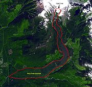
Soon before or after the buried ice had melted away, dacite
lava quietly erupted from Opal Cone
southeast of the Atwell Peak
plug dome 10,700 to 9,300 years ago and flowed 20 km (12 mi) down Ring Creek
on Garibaldi's southern and southwestern flanks without encountering any residual glacial ice. One of the lava flows traveled down a 30% to 35% grade over the landslide scar on the western flank. About 0.15 cubic mile (0.62522727375 km³) of dacite erupted in Garibaldi's third period of activity. This lava forms a thin layer of solid rock on the southern and western sides of the volcano and contains well-defined lava flow margin levees. The Ring Creek lava flow is very unusual because lengthy lava flows are usually attained by fluid basalt
flows, except the Ring Creek flow is dacite
.
 Mount Garibaldi is one of the eleven Canadian volcanoes most strongly associated with recent seismic activity
; the others are Castle Rock
, Mount Edziza
, Mount Cayley
, Hoodoo Mountain
, The Volcano
, Crow Lagoon
, Silverthrone Caldera
, Mount Meager
, Wells Gray-Clearwater Volcanic Field
and Nazko Cone
. The mountain is informally described as "dormant" ("asleep") because the mountain has not erupted in historic times, nor does it display fumarolic
activity like nearby Mount Baker
. However, seismic data suggests that these volcanoes still contain living magma
plumbing systems, indicating possible future eruptive activity. Although the available data does not allow a clear conclusion, these observations are further indications that some of Canada's volcanoes are potentially active, and that their associated hazards may be significant. The seismic activity correlates both with some of Canada's most youthful volcanoes, and with long-lived volcanic centers with a history of significant explosive behavior, such as Mount Garibaldi. No hot spring
s are known in the Garibaldi area like those found at Mount Meager
and Mount Cayley
, the other major volcanic complexes in the Garibaldi belt, although there are hints of anomalously high local heat flow in Table Meadows and elsewhere.
 Volcanic eruptions in Canada rarely cause fatalities because of their remoteness and low level of activity. The only known fatality due to volcanic activity in Canada occurred at the Tseax Cone
in 1775, when a 22.5 km (14 mi) long basalt
ic lava flow travelled down the Tseax
and Nass River
s, destroying a Nisga'a
village and killing approximately 2,000 people by volcanic gas
es. Many towns and cities near Mount Garibaldi are home to over half of British Columbia's human population, and there is a likelihood that future eruptions will cause damage to populated areas, making Mount Garibaldi and other Garibaldi belt volcanoes a major hazard. There are significant hazards from almost all Canadian volcanoes that require hazard maps and emergency plans. Volcanoes which exhibit significant seismic activity, such as Mount Garibaldi, appear to be most likely to erupt. A significant eruption of any of the Garibaldi belt volcanoes would significantly impact Highway 99 and communities like Pemberton
, Whistler
and Squamish
, and possibly Vancouver
.
 Explosive eruptions from Mount Garibaldi would pose a severe threat to the nearby communities of Whistler
and Squamish
. Although no Plinian eruption
s have been identified in Garibaldi's eruptive history, even Peléan eruption
s could create large amounts of ash that could significantly affect these local communities. Ash columns may rise to several hundred meters above the volcano, and due to its close proximity to Vancouver
this could pose a threat for air traffic. Melting of leftover glacial ice covering the Mount Garibaldi area may cause flood
s, lahar
s, or debris flow
s that could possibly threaten small communities such as Brackendale. Highway 99 is already plagued by landslide
s and debris flows from the steep rugged Coast Mountains. An eruption creating floods could demolish sections of the highway. Flooding and debris flows could also have severe issues for the salmon fishery on the Squamish
, Cheakamus
, and Mamquam
river
s. In addition, explosive eruption
s and the associated ash column could cause short-and long-term water supply difficulties for Vancouver and most of the lower mainland. The catchment area for the Greater Vancouver watershed is close to the Garibaldi area. Pyroclastic fall
could also have a deleterious effect on the ice fields to the east of Mount Garibaldi, causing more melting and spring flooding. This in turn could endanger water supplies from Pitt Lake
as well as fisheries on the Pitt River
.
 The hazard from lava flows would be low to moderate because the nature of the lavas would prevent them from travelling far from their source, even though the Ring Creek
lava flow ends only 6 km (4 mi) from Squamish. Magma with high to intermediate levels of silica (as in andesite
, dacite
or rhyolite
) commonly move slowly and typically cover small areas to form steep-sided mounds called lava dome
s. Lava domes often grow by the extrusion of many individual flows less than 30 m (98 ft) thick over a period of several months or years. Such flows will overlap one another and typically move less than a few meters per hour. Lava flows with high to intermediate levels of silica rarely extend more than 8 km (5 mi) from their source; for example, Garibaldi's 20 km (12 mi) long Ring Creek dacite
lava flow.
s. A section of the mountain collapsed into the Cheakamus River
valley when the glacier Garibaldi was built on melted, creating a jagged unstable slope at the head of the Cheekye River
. Repeated landslides from this steep cliff have created a huge debris fan at the mouth of the Cheekye River just north of Brackendale called the Cheekye Fan
. Danger from future collapses have limited the growth of Brackendale onto the fan.
The steep northern edge of The Barrier
in the Garibaldi area has partly collapsed several times, the most recent being in 1855-56. This collapse created a large boulder field below it, which gave Rubble Creek
its name. Danger from future collapses prompted the provincial government to declare the area immediately below it unsafe for human habitation in 1981. This led to the evacuation of the small resort village of Garibaldi
nearby, and the relocation of residents to new recreational subdivisions away from the hazard zone. Although imminent danger is unlikely, special regulations exist to warn potential danger and to minimize the risk to life and property in the event of a landslide.
 Currently Mount Garibaldi is not monitored closely enough by the Geological Survey of Canada to ascertain how active the volcano's magma system is. The existing network of seismographs
has been established to monitor tectonic earthquakes and is too far away to provide a good indication of what is happening beneath the mountain. It may sense an increase in activity if the volcano becomes very restless, but this may only provide a warning for a large eruption. It might detect activity only once the volcano has started erupting.
A possible way to detect an eruption is studying Garibaldi's geological history since every volcano has its own pattern of behaviour, in terms of its eruption style, magnitude and frequency, so that its future eruption is expected to be similar to its previous eruptions.
While there is a likelihood of Canada being critically effected by local or close by volcanic eruptions argues that some kind of improvement program is required. Benefit-cost thoughts are critical to dealing with natural hazards. However, a benefit-cost examination needs correct data about the hazard types, magnitudes and occurrences. These do not exist for volcanoes in British Columbia or elsewhere in Canada in the detail required.
Other volcanic techniques, such as hazard mapping, displays a volcano's eruptive history in detail and speculates an understanding of the hazardous activity that could possibly be expected in the future. At present no hazard maps have been created for Mount Garibaldi because the level of knowledge is insufficient due to its remoteness. A large volcanic hazard program has never existed within the Geological Survey of Canada. The majority of information has been collected in a lengthy, separate way from the support of several employees, such as volcanologist
s and other geologic scientist
s. Current knowledge is best established at Mount Meager
north of Mount Garibaldi and is likely to rise considerably with a temporary mapping and monitoring project. Knowledge at Mount Garibaldi and other volcanoes in the Garibaldi Volcanic Belt is not as established, but certain contributions are being done at least Mount Cayley
. An intensive program classifying infrastructural exposure near all young Canadian volcanoes and quick hazard assessments at each individual volcanic edifice associated with recent seismic activity would be in advance and would produce a quick and productive determination of priority areas for further efforts.
 The existing network of seismographs to monitor tectonic earthquakes has existed since 1975, although it remained small in population until 1985. Apart from a few short-term seismic monitoring experiments by the Geological Survey of Canada, no volcano monitoring has been accomplished at Mount Garibaldi or at other volcanoes in Canada at a level approaching that in other established countries with historically active volcanoes. Active or restless volcanoes are usually monitored using at least three seismographs all within approximately 15 km (9 mi), and frequently within 5 km (3 mi), for better sensitivity of detection and reduced location errors, particularly for earthquake depth. Such monitoring detects the risk of an eruption, offering a forecasting capability which is important to mitigating volcanic risk. Currently Mount Garibaldi does not have a seismograph closer than 25 km (16 mi). With increasing distance and declining numbers of seismographs used to indicate seismic activity, the prediction capability is reduced because earthquake location accuracy and depth decreases, and the network becomes less accurate. The inaccurate earthquake locations in the Garibaldi Volcanic Belt are a few kilometers, and in more isolated northern regions they are up to 10 km (6 mi). The location magnitude level in the Garibaldi Volcanic Belt is about magnitude 1 to 1.5, and elsewhere it is magnitude 1.5 to 2. At carefully monitored volcanoes both the located and noticed events are recorded and surveyed immediately to improve the understanding of a future eruption. Undetected events are not recorded or surveyed in British Columbia immediately, nor in an easy-to-access process.
In countries like Canada it is possible that small precursor earthquake swarms might go undetected, particularly if no events were observed; more significant events in larger swarms would be detected but only a minor subdivision of the swarm events would be complex to clarify them with confidence as volcanic in nature, or even associate them with an individual volcanic edifice.
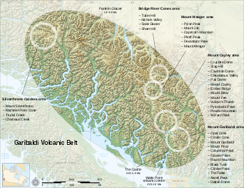
 Mount Garibaldi is associated with a group of small volcanoes that form the Garibaldi Lake volcanic field
. An unusual volcanic structure called The Table
is located between Garibaldi Lake
and Mount Garibaldi. This several-hundred-foot-high flat-topped volcano is made of layers of andesitic
dacite that are arranged like a stack of more or less equal sized pancake
s. The Table was formed in the early Holocene
at a time when the Cordilleran ice sheet
covered the region. As the volcano's lava rose it melted the part of the ice sheet above The Table's vent, creating space for the lava to move into. Repeated eruptions constructed the steep-walled stack of lava seen today.
Black Tusk
is a large spire of extensively eroded dark volcanic rock
that is shaped like a Walrus
tusk
. It is considered to be the remnant of an extinct andesitic
stratovolcano
which formed between about 1.3 and 1.1 million years ago.
Mount Price, west of Garibaldi Lake, 5 km south of Black Tusk, was formed in three stages of activity, dating back 1.1 million years, the latest of which produced two large lava flows
from Clinker Peak
during the early Holocene that ponded against the retreating continental ice sheet
and formed The Barrier
, containing Garibaldi Lake.
Cinder Cone
stands 150 m (492 ft) above a gap between two arms of Helmet Glacier on Garibaldi's flanks. During summer its crater
is filled with a snow melt lake.
Stratovolcano
A stratovolcano, also known as a composite volcano, is a tall, conical volcano built up by many layers of hardened lava, tephra, pumice, and volcanic ash. Unlike shield volcanoes, stratovolcanoes are characterized by a steep profile and periodic, explosive eruptions...
in the Sea to Sky Country of British Columbia
British Columbia
British Columbia is the westernmost of Canada's provinces and is known for its natural beauty, as reflected in its Latin motto, Splendor sine occasu . Its name was chosen by Queen Victoria in 1858...
, 80 km (50 mi) north of Vancouver
Vancouver
Vancouver is a coastal seaport city on the mainland of British Columbia, Canada. It is the hub of Greater Vancouver, which, with over 2.3 million residents, is the third most populous metropolitan area in the country,...
, Canada
Canada
Canada is a North American country consisting of ten provinces and three territories. Located in the northern part of the continent, it extends from the Atlantic Ocean in the east to the Pacific Ocean in the west, and northward into the Arctic Ocean...
. Located in the southernmost Coast Mountains
Coast Mountains
The Coast Mountains are a major mountain range, in the Pacific Coast Ranges, of western North America, extending from southwestern Yukon through the Alaska Panhandle and virtually all of the Coast of British Columbia. They are so-named because of their proximity to the sea coast, and are often...
, it is one of the most recognized peaks in the South Coast
British Columbia Coast
The British Columbia Coast or BC Coast is Canada's western continental coastline on the Pacific Ocean. The usage is synonymous with the term West Coast of Canada....
region, as well as British Columbia's best known volcano. It lies within the Garibaldi Ranges
Garibaldi Ranges
The Garibaldi Ranges are the next-to-southwesternmost subdivision of the Pacific Ranges of the Coast Mountains; only the North Shore Mountains are farther south. They lie between the valley formed by the pass between the Cheakamus River and Green River on the west and the valley of the Lillooet...
of the Pacific Ranges
Pacific Ranges
The Pacific Ranges are the southernmost subdivision of the Coast Mountains portion of the Pacific Cordillera. Located entirely within British Columbia, Canada, they run northwest from the lower stretches of the Fraser River to Bella Coola, north of which are the Kitimat Ranges.The Pacific Ranges...
.
This heavily eroded
Erosion
Erosion is when materials are removed from the surface and changed into something else. It only works by hydraulic actions and transport of solids in the natural environment, and leads to the deposition of these materials elsewhere...
dome
Lava dome
|250px|thumb|right|Image of the [[rhyolitic]] lava dome of [[Chaitén Volcano]] during its 2008–2009 eruption.In volcanology, a lava dome is a roughly circular mound-shaped protrusion resulting from the slow extrusion of viscous lava from a volcano...
complex occupies the southwest corner of Garibaldi Provincial Park
Garibaldi Provincial Park
Garibaldi Provincial Park, also called Garibaldi Park, is a wilderness park located in British Columbia, Canada, about 70 kilometres north of Vancouver. The park is located to the east of the Sea to Sky Highway between Squamish and Whistler and covers an area of over 1,950 square kilometres...
overlooking the town of Squamish
Squamish, British Columbia
Squamish is a community and a district municipality in the Canadian province of British Columbia, located at the north end of Howe Sound on the Sea to Sky Highway...
. It is the only major Pleistocene
Pleistocene
The Pleistocene is the epoch from 2,588,000 to 11,700 years BP that spans the world's recent period of repeated glaciations. The name pleistocene is derived from the Greek and ....
age volcano in North America
North America
North America is a continent wholly within the Northern Hemisphere and almost wholly within the Western Hemisphere. It is also considered a northern subcontinent of the Americas...
known to have formed upon a glacier. Although part of the Garibaldi Volcanic Belt
Garibaldi Volcanic Belt
The Garibaldi Volcanic Belt, also called the Canadian Cascade Arc, is a northwest-southeast trending volcanic chain in the Pacific Ranges of the Coast Mountains that extends from Watts Point in the south to the Ha-Iltzuk Icefield in the north. This chain of volcanoes is located in southwestern...
within the Cascade Volcanic Arc, it is not considered part of the Cascade Range
Cascade Range
The Cascade Range is a major mountain range of western North America, extending from southern British Columbia through Washington and Oregon to Northern California. It includes both non-volcanic mountains, such as the North Cascades, and the notable volcanoes known as the High Cascades...
.
Indigenous people
To Sḵwxwú7mesh, the local indigenous peopleIndigenous peoples of the Pacific Northwest Coast
The Indigenous peoples of the Pacific Northwest Coast are the pre-Columbian inhabitants of the Pacific Northwest Coast, their descendants, and many ethnic groups who identify with those historical peoples. They are now situated within the Canadian Province of British Columbia and the U.S...
of this territory, the mountain is called Nch'kay. In their language it means "Dirty Place" or "Grimy One". This name of the mountain refers to the muddy water in the Cheekye River
Cheekye River
The Cheekye River is a river in southwestern British Columbia, Canada. It flows west into the Cheakamus River and north of Squamish.-References:...
. This mountain, like others located in the area, is considered sacred for it plays an important part in their history. In their oral history
Oral tradition
Oral tradition and oral lore is cultural material and traditions transmitted orally from one generation to another. The messages or testimony are verbally transmitted in speech or song and may take the form, for example, of folktales, sayings, ballads, songs, or chants...
, they passed down a story of the flood covering the land. During this time, only two mountains peaked over the water, and this mountain was one of them. It was here that the remaining survivors of the flood latched their canoes to the peak and waited for the waters to subside. The mountain also serves as weather indicator to the people, as when clouds cover the face of the mountain, it signals the coming of rain or snow. Cultural ceremonial use, hunting, trapping and plant gathering occur around the Mount Garibaldi area, but the most important resource was a lithic
Lithic
Lithic may refer to:*a stone tool*Lithic analysis*Lithic stage*Lithic core *Lithic reduction *Lithic technology *Lithic flake *Lithic fragment...
material called obsidian
Obsidian
Obsidian is a naturally occurring volcanic glass formed as an extrusive igneous rock.It is produced when felsic lava extruded from a volcano cools rapidly with minimum crystal growth...
. Obsidian is a black volcanic glass that was used to make knives, chisels, adze
Adze
An adze is a tool used for smoothing or carving rough-cut wood in hand woodworking. Generally, the user stands astride a board or log and swings the adze downwards towards his feet, chipping off pieces of wood, moving backwards as they go and leaving a relatively smooth surface behind...
s, and other sharp tools in pre-contact times. This material appears in sites dated to 10,000 years ago up to “protohistoric time periods. The source for this material is found in upper parts of the mountain area in higher elevations that surround the mountain range.
Later history
British Explorer CaptainCaptain (naval)
Captain is the name most often given in English-speaking navies to the rank corresponding to command of the largest ships. The NATO rank code is OF-5, equivalent to an army full colonel....
George Vancouver
George Vancouver
Captain George Vancouver RN was an English officer of the British Royal Navy, best known for his 1791-95 expedition, which explored and charted North America's northwestern Pacific Coast regions, including the coasts of contemporary Alaska, British Columbia, Washington and Oregon...
reached Howe Sound
Howe Sound
Howe Sound is a roughly triangular sound, actually a network of fjords situated immediately northwest of Vancouver.-Geography:Howe Sound's mouth at the Strait of Georgia is situated between West Vancouver and the Sunshine Coast. The sound is triangular shaped, open on its southeast towards the...
in June 1792 and became the first European to see the mountain. During this time George Vancouver met and traded with the local natives in the area.
Royal Navy
The Royal Navy is the naval warfare service branch of the British Armed Forces. Founded in the 16th century, it is the oldest service branch and is known as the Senior Service...
survey ship HMS Plumper, Captain George Henry Richards
George Henry Richards
Admiral Sir George Henry Richards was Hydrographer to the British Admiralty from 1864 to 1874.-Early life:Richards was born in Anthony, Cornwall, the son of Captain G S Richards, and joined the navy in 1832....
was impressed by a gigantic mountain dominating the view to the northeast. Captain Richards, and his officers, re-named the mountain after the Italian military and political leader Giuseppe Garibaldi
Giuseppe Garibaldi
Giuseppe Garibaldi was an Italian military and political figure. In his twenties, he joined the Carbonari Italian patriot revolutionaries, and fled Italy after a failed insurrection. Garibaldi took part in the War of the Farrapos and the Uruguayan Civil War leading the Italian Legion, and...
, who that year had succeeded in unifying Italy
Italy
Italy , officially the Italian Republic languages]] under the European Charter for Regional or Minority Languages. In each of these, Italy's official name is as follows:;;;;;;;;), is a unitary parliamentary republic in South-Central Europe. To the north it borders France, Switzerland, Austria and...
by patriating Sicily
Sicily
Sicily is a region of Italy, and is the largest island in the Mediterranean Sea. Along with the surrounding minor islands, it constitutes an autonomous region of Italy, the Regione Autonoma Siciliana Sicily has a rich and unique culture, especially with regard to the arts, music, literature,...
and Naples
Naples
Naples is a city in Southern Italy, situated on the country's west coast by the Gulf of Naples. Lying between two notable volcanic regions, Mount Vesuvius and the Phlegraean Fields, it is the capital of the region of Campania and of the province of Naples...
. In August 1907, the Vancouver
Vancouver
Vancouver is a coastal seaport city on the mainland of British Columbia, Canada. It is the hub of Greater Vancouver, which, with over 2.3 million residents, is the third most populous metropolitan area in the country,...
mountaineers A. Dalton, W. Dalton, A. King, T. Pattison, J.J. Trorey, and G. Warren reached the summit of Mount Garibaldi. The views from the peak inspired the establishment of summer climbing camps at Garibaldi Lake
Garibaldi Lake
The Garibaldi Lake volcanic field is a volcanic field, located in British Columbia, Canada. It was formed by a group of nine small andesitic stratovolcanoes and basaltic andesite vents in the scenic Garibaldi Lake area immediately north of Mount Garibaldi was formed during the late Pleistocene and...
. This early interest led to the creation in 1920 of a park reserve.
In 1927, Garibaldi was made into a large wilderness park called Garibaldi Provincial Park
Garibaldi Provincial Park
Garibaldi Provincial Park, also called Garibaldi Park, is a wilderness park located in British Columbia, Canada, about 70 kilometres north of Vancouver. The park is located to the east of the Sea to Sky Highway between Squamish and Whistler and covers an area of over 1,950 square kilometres...
. Named after Mount Garibaldi, this 1,946.5 square kilometre park was established to protect the rich geological history, diverse vegetation, iridescent waters, abundant wildlife, and rugged mountains, many of which are capped by glaciers.
When skiing caught on in the 1940s, Vancouver skiers began to search the glacier
Glacier
A glacier is a large persistent body of ice that forms where the accumulation of snow exceeds its ablation over many years, often centuries. At least 0.1 km² in area and 50 m thick, but often much larger, a glacier slowly deforms and flows due to stresses induced by its weight...
s and rugged mountains within the park. Early skiing was limited to the more easily reached area around Garibaldi Lake
Garibaldi Lake
The Garibaldi Lake volcanic field is a volcanic field, located in British Columbia, Canada. It was formed by a group of nine small andesitic stratovolcanoes and basaltic andesite vents in the scenic Garibaldi Lake area immediately north of Mount Garibaldi was formed during the late Pleistocene and...
. In the winter of 1944, a club group completed the first possible ski of Mount Garibaldi. The famous mountaineers Don
Don Munday
Walter Alfred Don Munday was a Canadian explorer, naturalist and mountaineer famous for his explorations of the Coast Mountains with his wife Phyllis, and especially for the exploration of the Waddington Range....
and Phyllis Munday
Phyllis Munday
Phyllis B Munday, CM was a Canadian mountaineer, explorer, naturalist and humanitarian, famed for being the first woman to reach the summit of Mount Robson in 1924, and with her husband Don for discovering Mount Waddington, and exploring the area around it via the Franklin River and the Homathko...
completed lots of tracks additionally. In the 1944-45 Canadian Alpine Journal, the Mundays reported a ski attempt on Mount Garibaldi with Phil Brook, who was a friend of the Mundays. They skied on Sphinx Glacier and scrabbled Panorama Ridge just north of Garibaldi Lake
Garibaldi Lake
The Garibaldi Lake volcanic field is a volcanic field, located in British Columbia, Canada. It was formed by a group of nine small andesitic stratovolcanoes and basaltic andesite vents in the scenic Garibaldi Lake area immediately north of Mount Garibaldi was formed during the late Pleistocene and...
during the same trip. Most importantly, during this period a road was built on Paul Ridge near the small community of Squamish
Squamish, British Columbia
Squamish is a community and a district municipality in the Canadian province of British Columbia, located at the north end of Howe Sound on the Sea to Sky Highway...
at the north end of Howe Sound
Howe Sound
Howe Sound is a roughly triangular sound, actually a network of fjords situated immediately northwest of Vancouver.-Geography:Howe Sound's mouth at the Strait of Georgia is situated between West Vancouver and the Sunshine Coast. The sound is triangular shaped, open on its southeast towards the...
, therefore granted better vehicle approach to the highlands near Mount Garibaldi. With easier access Vancouver skiers spent even more time on the glaciers of Mount Garibaldi. The result of this was the formation in the 1940s of the Garibaldi Névé Traverse, an overnight adventure that (weather permitting) can include a fine descent of Mount Garibaldi.
Subsidiary peaks
Atwell Peak
Atwell Peak is a dramatic pyramid shaped volcanic peak located at the southern edge of Mount Garibaldi, British Columbia, Canada. Atwell Peak was formed during an initial period of volcanism 0.51-0.22 million years ago and was the source of many pyroclastic flows during Garibaldi's development....
at the southern edge of the summit plateau, which reaches a height of 2655 m (8,711 ft) and lies on the southwest end of Garibaldi Provincial Park. This peak is named after Atwell Duncan Francis Joseph King, leader of the first ascent of Mount Garibaldi in 1907. The lowest of the three is the rounded Dalton Dome, 2653 m (8,704 ft) high, west of the highest summit. This peak is named after Arthur Tinniswood Dalton, one of the guides of the 1907 ascent.
A feature on the north side of the mountain, known as The Tent, reaches 2465 m (8,087 ft) and lies in Garibaldi Provincial Park. Another minor summit on the south side of the mountain, 2056 m (6,745 ft) high, is known as Diamond Head (sometimes Little Diamond Head) for its resemblance to Diamond Head
Diamond Head, Hawaii
Diamond Head is the name of a volcanic tuff cone on the Hawaiian island of Oahu and known to Hawaiians as Lēahi, most likely from lae 'browridge, promontory' plus ahi 'tuna' because the shape of the ridgeline resembles the shape of a tuna's dorsal fin...
in Hawaii
Hawaii
Hawaii is the newest of the 50 U.S. states , and is the only U.S. state made up entirely of islands. It is the northernmost island group in Polynesia, occupying most of an archipelago in the central Pacific Ocean, southwest of the continental United States, southeast of Japan, and northeast of...
. Diamond Head was the site of a ski proposal and small lodge, now derelict. On the northwest side of Mount Garibaldi, Brohm Ridge lies outside the western boundary of Garibaldi Provincial Park. The Sharkfin sticks up out of the Warren Glacier on the northeast side of the mountain with a height of 2000 m (6,562 ft), just northeast of Squamish
Squamish, British Columbia
Squamish is a community and a district municipality in the Canadian province of British Columbia, located at the north end of Howe Sound on the Sea to Sky Highway...
. Columnar Peak rises on the south side of the mountain with a height of 1826 m (5,991 ft), just southwest of Mamquam Lake at southwest end of Garibaldi Provincial Park. Two pinnacle
Pinnacle
A pinnacle is an architectural ornament originally forming the cap or crown of a buttress or small turret, but afterwards used on parapets at the corners of towers and in many other situations. The pinnacle looks like a small spire...
s of volcanic rock
Volcanic rock
Volcanic rock is a rock formed from magma erupted from a volcano. In other words, it is an igneous rock of volcanic origin...
5 km (3 mi) south of Mount Garibaldi's summit, which attain heights of 1816 m (5,958 ft) and 1823 m (5,981 ft), have been known as The Gargoyles since 1978.
Glaciers and icefields
Two pocket glaciers lie right below the east side of Atwell PeakAtwell Peak
Atwell Peak is a dramatic pyramid shaped volcanic peak located at the southern edge of Mount Garibaldi, British Columbia, Canada. Atwell Peak was formed during an initial period of volcanism 0.51-0.22 million years ago and was the source of many pyroclastic flows during Garibaldi's development....
, the Diamond Glacier
Diamond Glacier
Diamond Glacier is a glacier in the Garibaldi Ranges of the Pacific Ranges in southwestern British Columbia, Canada. It lies on the Mount Garibaldi massif between Atwell Peak and Diamond Head.-References:...
to the southeast and the upper Bishop Glacier to the northeast. Straight north of Atwell toward Mount Garibaldi lies a small, high-elevation ice cap called the Cheekye Glacier, the name of which is associated with Cheekye River
Cheekye River
The Cheekye River is a river in southwestern British Columbia, Canada. It flows west into the Cheakamus River and north of Squamish.-References:...
.
A large icefield lies on the eastern and northern flanks of Mount Garibaldi called the Garibaldi Névé
Garibaldi Névé
The Garibaldi Névé is a large icefield in the Pacific Ranges of the Coast Mountains in southwestern British Columbia, Canada, located on the eastern flank of Mount Garibaldi.-References:...
. Its drainage is to the east into the Pitt River
Pitt River
The Pitt River in British Columbia, Canada is a large tributary of the Fraser River, entering it a few miles upstream from New Westminster and about 25 km ESE of Downtown Vancouver. The river, which begins in the Garibaldi Ranges of the Coast Mountains, is in two sections above and below Pitt...
, to the southwest into Garibaldi Lake
Garibaldi Lake
The Garibaldi Lake volcanic field is a volcanic field, located in British Columbia, Canada. It was formed by a group of nine small andesitic stratovolcanoes and basaltic andesite vents in the scenic Garibaldi Lake area immediately north of Mount Garibaldi was formed during the late Pleistocene and...
. It has an area of 35 km2 and is an area of substantial snowfall with more than 5 m (16 ft) in many winters. The Garibaldi Névé is usually accessed from the south through the Bishop Glacier or from the north through the Sentinel Glacier.
Climbing and recreation
Mountaineering
Mountaineering or mountain climbing is the sport, hobby or profession of hiking, skiing, and climbing mountains. While mountaineering began as attempts to reach the highest point of unclimbed mountains it has branched into specialisations that address different aspects of the mountain and consists...
on Mount Garibaldi is fairly difficult; it is fairly steep-sided and involves climbing very loose rotten lava
Lava
Lava refers both to molten rock expelled by a volcano during an eruption and the resulting rock after solidification and cooling. This molten rock is formed in the interior of some planets, including Earth, and some of their satellites. When first erupted from a volcanic vent, lava is a liquid at...
and volcanic ash
Volcanic ash
Volcanic ash consists of small tephra, which are bits of pulverized rock and glass created by volcanic eruptions, less than in diameter. There are three mechanisms of volcanic ash formation: gas release under decompression causing magmatic eruptions; thermal contraction from chilling on contact...
. Fortunately, Mount Garibaldi has large areas of massive glaciation and extensive snowfields. The eastern and northern flanks of the mountain are smothered by the Garibaldi Névé
Garibaldi Névé
The Garibaldi Névé is a large icefield in the Pacific Ranges of the Coast Mountains in southwestern British Columbia, Canada, located on the eastern flank of Mount Garibaldi.-References:...
where the finest climbing opportunities exist, making the easiest route a glacial travel or snow climb. Routes keep mostly to the alpine glacier
Glacier
A glacier is a large persistent body of ice that forms where the accumulation of snow exceeds its ablation over many years, often centuries. At least 0.1 km² in area and 50 m thick, but often much larger, a glacier slowly deforms and flows due to stresses induced by its weight...
s and snow slopes, which are abundant in winter and spring, but eventually melt in late spring and commonly vanish after June or July of most years. After the snow and ice melts, fissures and fractures can pose difficulty and danger, and avalanches from higher peaks of the mountain are a hazard. For this reason, early season, cold-weather ascents are recommended for most routes up Garibaldi.
Hiking
Hiking
Hiking is an outdoor activity which consists of walking in natural environments, often in mountainous or other scenic terrain. People often hike on hiking trails. It is such a popular activity that there are numerous hiking organizations worldwide. The health benefits of different types of hiking...
, photography
Photography
Photography is the art, science and practice of creating durable images by recording light or other electromagnetic radiation, either electronically by means of an image sensor or chemically by means of a light-sensitive material such as photographic film...
, and camping
Camping
Camping is an outdoor recreational activity. The participants leave urban areas, their home region, or civilization and enjoy nature while spending one or several nights outdoors, usually at a campsite. Camping may involve the use of a tent, caravan, motorhome, cabin, a primitive structure, or no...
are popular in the Garibaldi area. Hiking trails, including the Garibaldi Lake Trail, a 6 km (4 mi) circumnavigation of the peak provide access to the backcountry. Mount Garibaldi is also popular for winter sports, including cross-country skiing. In summer, visitors pass through meadows of wildflowers, on trails emanating from Garibaldi Provincial Park.
Geology
Granite
Granite is a common and widely occurring type of intrusive, felsic, igneous rock. Granite usually has a medium- to coarse-grained texture. Occasionally some individual crystals are larger than the groundmass, in which case the texture is known as porphyritic. A granitic rock with a porphyritic...
outcropping in North America. The intrusive
Intrusion
An intrusion is liquid rock that forms under Earth's surface. Magma from under the surface is slowly pushed up from deep within the earth into any cracks or spaces it can find, sometimes pushing existing country rock out of the way, a process that can take millions of years. As the rock slowly...
and metamorphic rock
Metamorphic rock
Metamorphic rock is the transformation of an existing rock type, the protolith, in a process called metamorphism, which means "change in form". The protolith is subjected to heat and pressure causing profound physical and/or chemical change...
s extend approximately 1800 km (1,118 mi) along the coast of British Columbia, the Alaska Panhandle
Alaska Panhandle
Southeast Alaska, sometimes referred to as the Alaska Panhandle, is the southeastern portion of the U.S. state of Alaska, which lies west of the northern half of the Canadian province of British Columbia. The majority of Southeast Alaska's area is part of the Tongass National Forest, the United...
and southwestern Yukon
Yukon
Yukon is the westernmost and smallest of Canada's three federal territories. It was named after the Yukon River. The word Yukon means "Great River" in Gwich’in....
. This is a remnant of a once vast volcanic arc
Volcanic arc
A volcanic arc is a chain of volcanoes positioned in an arc shape as seen from above. Offshore volcanoes form islands, resulting in a volcanic island arc. Generally they result from the subduction of an oceanic tectonic plate under another tectonic plate, and often parallel an oceanic trench...
called the Coast Range Arc that formed as a result of subduction
Subduction
In geology, subduction is the process that takes place at convergent boundaries by which one tectonic plate moves under another tectonic plate, sinking into the Earth's mantle, as the plates converge. These 3D regions of mantle downwellings are known as "Subduction Zones"...
of the Farallon
Farallon Plate
The Farallon Plate was an ancient oceanic plate, which began subducting under the west coast of the North American Plate— then located in modern Utah— as Pangaea broke apart during the Jurassic Period...
and Kula Plate
Kula Plate
The Kula Plate is an oceanic tectonic plate under the northern Pacific Ocean south of the Near Islands segment of the Aleutian Islands. It is subducting under the North American Plate at the Aleutian Trench and is surrounded by the Pacific Plate...
s during the Jurassic
Jurassic
The Jurassic is a geologic period and system that extends from about Mya to Mya, that is, from the end of the Triassic to the beginning of the Cretaceous. The Jurassic constitutes the middle period of the Mesozoic era, also known as the age of reptiles. The start of the period is marked by...
-to-Eocene
Eocene
The Eocene Epoch, lasting from about 56 to 34 million years ago , is a major division of the geologic timescale and the second epoch of the Paleogene Period in the Cenozoic Era. The Eocene spans the time from the end of the Palaeocene Epoch to the beginning of the Oligocene Epoch. The start of the...
periods. In contrast, Garibaldi, Meager
Mount Meager
Mount Meager, originally known as Meager Mountain, is a complex volcano in the Sea-to-Sky Corridor of southwestern British Columbia, Canada. It is located north of Vancouver at the northern end of the Pemberton Valley. Part of the Cascade Volcanic Arc of western North America, its summit is above...
, Cayley
Mount Cayley
Mount Cayley is a potentially active stratovolcano in Squamish-Lillooet Regional District of southwestern British Columbia, Canada. Located north of Squamish and west of Whistler in the Pacific Ranges of the Coast Mountains, it rises above the Squamish River to the west and above the Cheakamus...
and Silverthrone
Silverthrone Caldera
The Silverthrone Caldera is a potentially active caldera complex in southwestern British Columbia, Canada, located over northwest of the city of Vancouver and about west of Mount Waddington in the Pacific Ranges of the Coast Mountains. The caldera is one of the largest of the few calderas in...
areas are of recent volcanic origin.
Mount Garibaldi is one of the few Cascade volcanoes that is made exclusively of dacite
Dacite
Dacite is an igneous, volcanic rock. It has an aphanitic to porphyritic texture and is intermediate in composition between andesite and rhyolite. The relative proportions of feldspars and quartz in dacite, and in many other volcanic rocks, are illustrated in the QAPF diagram...
(Glacier Peak
Glacier Peak
Glacier Peak is the most isolated of the five major stratovolcanoes of the Cascade Volcanic Arc in Washington...
is the other). The mountain
Mountain
Image:Himalaya_annotated.jpg|thumb|right|The Himalayan mountain range with Mount Everestrect 58 14 160 49 Chomo Lonzorect 200 28 335 52 Makalurect 378 24 566 45 Mount Everestrect 188 581 920 656 Tibetan Plateaurect 250 406 340 427 Rong River...
has a unique asymmetrical shape because its main cone was constructed atop part of a large glacier
Glacier
A glacier is a large persistent body of ice that forms where the accumulation of snow exceeds its ablation over many years, often centuries. At least 0.1 km² in area and 50 m thick, but often much larger, a glacier slowly deforms and flows due to stresses induced by its weight...
system associated with the Cordilleran Ice Sheet
Cordilleran Ice Sheet
The Cordilleran ice sheet was a major ice sheet that covered, during glacial periods of the Quaternary, a large area of North America. This included the following areas:*Western Montana*The Idaho Panhandle...
that has since melted away. Unlike many of the other Cascade volcanoes to the south, Garibaldi does not dominate the surrounding landscape, which consists of many high, rugged peaks. Many residents of Vancouver are therefore not aware that there is a volcano closer to the city than the more easily visible Mount Baker
Mount Baker
Mount Baker , also known as Koma Kulshan or simply Kulshan, is an active glaciated andesitic stratovolcano in the Cascade Volcanic Arc and the North Cascades of Washington State in the United States. It is the second-most active volcano in the range after Mount Saint Helens...
in Washington State.
Origins
Cascadia subduction zone
The Cascadia subduction zone is a subduction zone, a type of convergent plate boundary that stretches from northern Vancouver Island to northern California. It is a very long sloping fault that separates the Juan de Fuca and North America plates.New ocean floor is being created offshore of...
—a long convergent plate boundary that stretches from mid-Vancouver Island
Vancouver Island
Vancouver Island is a large island in British Columbia, Canada. It is one of several North American locations named after George Vancouver, the British Royal Navy officer who explored the Pacific Northwest coast of North America between 1791 and 1794...
to Northern California
Northern California
Northern California is the northern portion of the U.S. state of California. The San Francisco Bay Area , and Sacramento as well as its metropolitan area are the main population centers...
. The subduction zone separates the Juan de Fuca
Juan de Fuca Plate
The Juan de Fuca Plate, named after the explorer of the same name, is a tectonic plate, generated from the Juan de Fuca Ridge, and subducting under the northerly portion of the western side of the North American Plate at the Cascadia subduction zone...
, Explorer
Explorer Plate
The Explorer Plate is an oceanic tectonic plate beneath the Pacific Ocean off the west coast of Vancouver Island, Canada.The eastern boundary of the Explorer Plate is being slowly subducted under the North American Plate, to which it may eventually accrete owing to the slow rate of subduction...
, Gorda
Gorda Plate
The Gorda Plate, located beneath the Pacific Ocean off the coast of northern California, is one of the northern remnants of the Farallon Plate. It is sometimes referred to as simply the southernmost portion of the neighboring Juan de Fuca Plate, another Farallon remnant.Unlike most tectonic...
and North American Plate
North American Plate
The North American Plate is a tectonic plate covering most of North America, Greenland, Cuba, Bahamas, and parts of Siberia, Japan and Iceland. It extends eastward to the Mid-Atlantic Ridge and westward to the Chersky Range in eastern Siberia. The plate includes both continental and oceanic crust...
s. Here, the oceanic crust
Oceanic crust
Oceanic crust is the part of Earth's lithosphere that surfaces in the ocean basins. Oceanic crust is primarily composed of mafic rocks, or sima, which is rich in iron and magnesium...
of the Pacific Ocean
Pacific Ocean
The Pacific Ocean is the largest of the Earth's oceanic divisions. It extends from the Arctic in the north to the Southern Ocean in the south, bounded by Asia and Australia in the west, and the Americas in the east.At 165.2 million square kilometres in area, this largest division of the World...
sinks beneath North America
North America
North America is a continent wholly within the Northern Hemisphere and almost wholly within the Western Hemisphere. It is also considered a northern subcontinent of the Americas...
at a rate of 40 millimetres (1.6 in) per year. Hot magma
Magma
Magma is a mixture of molten rock, volatiles and solids that is found beneath the surface of the Earth, and is expected to exist on other terrestrial planets. Besides molten rock, magma may also contain suspended crystals and dissolved gas and sometimes also gas bubbles. Magma often collects in...
upwelling above the descending oceanic plate creates volcanoes, and each individual volcano erupts for a few million years.
The subduction zone has existed for at least 37 million years, and has created a line of volcanoes called the Cascade Volcanic Arc which stretches over 1000 km (621 mi) along the subduction zone. Several volcanoes in the arc are potentially active. Lassen Peak
Lassen Peak
Lassen Peak is the southernmost active volcano in the Cascade Range. It is part of the Cascade Volcanic Arc which is an arc that stretches from northern California to southwestern British Columbia...
in California, which last erupted in 1917, is the southernmost historically active volcano in the arc, while Mount Meager
Mount Meager
Mount Meager, originally known as Meager Mountain, is a complex volcano in the Sea-to-Sky Corridor of southwestern British Columbia, Canada. It is located north of Vancouver at the northern end of the Pemberton Valley. Part of the Cascade Volcanic Arc of western North America, its summit is above...
, just north of Mount Garibaldi, which erupted about 2,350 years ago, is generally considered the northernmost. A few isolated volcanic centers northwest of Mount Meager, such as the Silverthrone Caldera
Silverthrone Caldera
The Silverthrone Caldera is a potentially active caldera complex in southwestern British Columbia, Canada, located over northwest of the city of Vancouver and about west of Mount Waddington in the Pacific Ranges of the Coast Mountains. The caldera is one of the largest of the few calderas in...
, which is a circular 20 km (12 mi) wide, deeply dissected caldera
Caldera
A caldera is a cauldron-like volcanic feature usually formed by the collapse of land following a volcanic eruption, such as the one at Yellowstone National Park in the US. They are sometimes confused with volcanic craters...
complex, are considered by some geologists to be the northernmost member of the arc.
Structure
Stratovolcano
A stratovolcano, also known as a composite volcano, is a tall, conical volcano built up by many layers of hardened lava, tephra, pumice, and volcanic ash. Unlike shield volcanoes, stratovolcanoes are characterized by a steep profile and periodic, explosive eruptions...
es, it is composed of many layers of hardened lava, tephra
Tephra
200px|thumb|right|Tephra horizons in south-central [[Iceland]]. The thick and light coloured layer at center of the photo is [[rhyolitic]] tephra from [[Hekla]]....
, and volcanic ash. Eruptions are explosive in nature, and the most common form is the Peléan
Pelean eruption
Peléan eruptions are a type of volcanic eruption. They can occur when viscous magma, typically of rhyolitic or andesitic type, is involved, and share some similarities with Vulcanian eruptions. The most important characteristics of a Peléan eruption is the presence of a glowing avalanche of hot...
style, which involves viscous magma
Magma
Magma is a mixture of molten rock, volatiles and solids that is found beneath the surface of the Earth, and is expected to exist on other terrestrial planets. Besides molten rock, magma may also contain suspended crystals and dissolved gas and sometimes also gas bubbles. Magma often collects in...
, glowing avalanches of hot volcanic ash
Volcanic ash
Volcanic ash consists of small tephra, which are bits of pulverized rock and glass created by volcanic eruptions, less than in diameter. There are three mechanisms of volcanic ash formation: gas release under decompression causing magmatic eruptions; thermal contraction from chilling on contact...
and pyroclastic flow
Pyroclastic flow
A pyroclastic flow is a fast-moving current of superheated gas and rock , which reaches speeds moving away from a volcano of up to 700 km/h . The flows normally hug the ground and travel downhill, or spread laterally under gravity...
s. The source magma of this rock is classified as acid
Acid
An acid is a substance which reacts with a base. Commonly, acids can be identified as tasting sour, reacting with metals such as calcium, and bases like sodium carbonate. Aqueous acids have a pH of less than 7, where an acid of lower pH is typically stronger, and turn blue litmus paper red...
ic, having high to intermediate levels of silica (as in rhyolite
Rhyolite
This page is about a volcanic rock. For the ghost town see Rhyolite, Nevada, and for the satellite system, see Rhyolite/Aquacade.Rhyolite is an igneous, volcanic rock, of felsic composition . It may have any texture from glassy to aphanitic to porphyritic...
, dacite
Dacite
Dacite is an igneous, volcanic rock. It has an aphanitic to porphyritic texture and is intermediate in composition between andesite and rhyolite. The relative proportions of feldspars and quartz in dacite, and in many other volcanic rocks, are illustrated in the QAPF diagram...
, or andesite
Andesite
Andesite is an extrusive igneous, volcanic rock, of intermediate composition, with aphanitic to porphyritic texture. In a general sense, it is the intermediate type between basalt and dacite. The mineral assemblage is typically dominated by plagioclase plus pyroxene and/or hornblende. Magnetite,...
). The tephra deposits have lower volume and range than the corresponding Plinian
Plinian eruption
Plinian eruptions, also known as 'Vesuvian eruptions', are volcanic eruptions marked by their similarity to the eruption of Mount Vesuvius in AD 79 ....
and Vulcanian eruption
Vulcanian eruption
The term Vulcanian was first used by Giuseppe Mercalli, witnessing the 1888-1890 eruptions on the island of Vulcano. His description of the eruption style is now used all over the world for eruptions characterised by a dense cloud of ash-laden gas exploding from the crater and rising high above the...
s.
Mount Garibaldi is known both for the very high quality exposures of its internal structure and for its conspicuous topographic
Topography
Topography is the study of Earth's surface shape and features or those ofplanets, moons, and asteroids...
anomalies, which can be attributed to the growth of the mountain onto a large glacier system and the subsequent collapse of the flanks of the volcano with the melting of the ice. The western flanks of the mountain expose basement rocks, sheared and altered quartz
Quartz
Quartz is the second-most-abundant mineral in the Earth's continental crust, after feldspar. It is made up of a continuous framework of SiO4 silicon–oxygen tetrahedra, with each oxygen being shared between two tetrahedra, giving an overall formula SiO2. There are many different varieties of quartz,...
diorite
Diorite
Diorite is a grey to dark grey intermediate intrusive igneous rock composed principally of plagioclase feldspar , biotite, hornblende, and/or pyroxene. It may contain small amounts of quartz, microcline and olivine. Zircon, apatite, sphene, magnetite, ilmenite and sulfides occur as accessory...
, carved by streams and glaciers into a rugged topography with relief up to 1800 m (5,906 ft). Valleys in this jagged surface have been filled with 0.52 to 0.22 million year old dacite
Dacite
Dacite is an igneous, volcanic rock. It has an aphanitic to porphyritic texture and is intermediate in composition between andesite and rhyolite. The relative proportions of feldspars and quartz in dacite, and in many other volcanic rocks, are illustrated in the QAPF diagram...
and andesite
Andesite
Andesite is an extrusive igneous, volcanic rock, of intermediate composition, with aphanitic to porphyritic texture. In a general sense, it is the intermediate type between basalt and dacite. The mineral assemblage is typically dominated by plagioclase plus pyroxene and/or hornblende. Magnetite,...
flows, tuff
Tuff
Tuff is a type of rock consisting of consolidated volcanic ash ejected from vents during a volcanic eruption. Tuff is sometimes called tufa, particularly when used as construction material, although tufa also refers to a quite different rock. Rock that contains greater than 50% tuff is considered...
breccia
Breccia
Breccia is a rock composed of broken fragments of minerals or rock cemented together by a fine-grained matrix, that can be either similar to or different from the composition of the fragments....
s, and domes
Lava dome
|250px|thumb|right|Image of the [[rhyolitic]] lava dome of [[Chaitén Volcano]] during its 2008–2009 eruption.In volcanology, a lava dome is a roughly circular mound-shaped protrusion resulting from the slow extrusion of viscous lava from a volcano...
, precursors of the activity at Mount Garibaldi. About 0.8 cubic miles (3.3 km³) of material remains in the volcano. In modern times, the apron of material around the volcano's main vent extends at least 4.8 km (3 mi) from its source in places that were covered by ice. In other areas its extent is less and its slope is steeper.
Stratovolcanoes are a common feature of subduction zones. The magma that forms them arises when water, which is trapped both in hydrated minerals and in the porous basalt
Basalt
Basalt is a common extrusive volcanic rock. It is usually grey to black and fine-grained due to rapid cooling of lava at the surface of a planet. It may be porphyritic containing larger crystals in a fine matrix, or vesicular, or frothy scoria. Unweathered basalt is black or grey...
rock of the upper oceanic crust, is released into mantle
Mantle (geology)
The mantle is a part of a terrestrial planet or other rocky body large enough to have differentiation by density. The interior of the Earth, similar to the other terrestrial planets, is chemically divided into layers. The mantle is a highly viscous layer between the crust and the outer core....
rock of the asthenosphere
Asthenosphere
The asthenosphere is the highly viscous, mechanically weak and ductilely-deforming region of the upper mantle of the Earth...
above the sinking oceanic slab. The release of water from hydrated minerals is termed "dewatering", and occurs at specific pressure/temperature conditions for specific minerals as the plate subducts to lower depths. The water freed from the subducting slab lowers the melting point
Melting point
The melting point of a solid is the temperature at which it changes state from solid to liquid. At the melting point the solid and liquid phase exist in equilibrium. The melting point of a substance depends on pressure and is usually specified at standard atmospheric pressure...
of the overlying mantle rock, which then undergoes partial melting and rises due to its density relative to the surrounding mantle rock, and pools temporarily at the base of the lithosphere
Lithosphere
The lithosphere is the rigid outermost shell of a rocky planet. On Earth, it comprises the crust and the portion of the upper mantle that behaves elastically on time scales of thousands of years or greater.- Earth's lithosphere :...
. The magma then rises through the crust
Crust (geology)
In geology, the crust is the outermost solid shell of a rocky planet or natural satellite, which is chemically distinct from the underlying mantle...
, incorporating silica rich crustal rock, leading to a final intermediate composition. When the magma nears the surface it pools in a magma chamber
Magma chamber
A magma chamber is a large underground pool of molten rock found beneath the surface of the Earth. The molten rock in such a chamber is under great pressure, and given enough time, that pressure can gradually fracture the rock around it creating outlets for the magma...
under the volcano. The relatively low pressure of the magma allows water and other volatiles
Volatility (chemistry)
In chemistry and physics, volatility is the tendency of a substance to vaporize. Volatility is directly related to a substance's vapor pressure. At a given temperature, a substance with higher vapor pressure vaporizes more readily than a substance with a lower vapor pressure.The term is primarily...
(CO2, S2-, Cl-) dissolved in the magma to begin to come out of solution, much like when a bottle of carbonated water
Carbonated water
Carbonated water is water into which carbon dioxide gas under pressure has been dissolved, a process that causes the water to become effervescent....
is opened. Once a critical volume of magma and gas accumulates, the obstacle provided by the volcanic cone
Volcanic cone
Volcanic cones are among the simplest volcanic formations. They are built by ejecta from a volcanic vent, piling up around the vent in the shape of a cone with a central crater. Volcanic cones are of different types, depending upon the nature and size of the fragments ejected during the eruption...
is overcome, leading to a sudden explosive eruption
Explosive eruption
An explosive eruption is a volcanic term to describe a violent, explosive type of eruption. Mount St. Helens in 1980 was an example. Such an eruption is driven by gas accumulating under great pressure. Driven by hot rising magma, it interacts with ground water until the pressure increases to the...
.
Ancestral stages of eruptive activity
Breccia
Breccia is a rock composed of broken fragments of minerals or rock cemented together by a fine-grained matrix, that can be either similar to or different from the composition of the fragments....
that has been potassium-argon dated
Potassium-argon dating
Potassium–argon dating or K–Ar dating is a radiometric dating method used in geochronology and archeology. It is based on measurement of the product of the radioactive decay of an isotope of potassium into argon . Potassium is a common element found in many materials, such as micas, clay minerals,...
to 250,000 years old. Parts of this "proto-Garibaldi" or ancestral volcano are exposed on Garibaldi's lower northern and eastern flanks and on the upper 240 m (787 ft) of Brohm Ridge. Around where Columnar Peak and possibly Glacier Pikes
Glacier Pikes
Glacier Pikes is a Lava dome, located in the Garibaldi Lake volcanic field, British Columbia, Canada. The dome has two rocky points at the southern end of the Sentinel Glacier Neve.-See also:*List of volcanoes in Canada*Volcanism of Canada...
are now located, a series of coalescing dacite lava dome
Lava dome
|250px|thumb|right|Image of the [[rhyolitic]] lava dome of [[Chaitén Volcano]] during its 2008–2009 eruption.In volcanology, a lava dome is a roughly circular mound-shaped protrusion resulting from the slow extrusion of viscous lava from a volcano...
s were constructed. During the ensuing long period of dormancy, the Cheekye River
Cheekye River
The Cheekye River is a river in southwestern British Columbia, Canada. It flows west into the Cheakamus River and north of Squamish.-References:...
cut a deep valley into the cone's western flank that was later filled with a glacier.
After reaching its maximum extent the Cheekye Glacier along with part of the area's ice sheet
Ice sheet
An ice sheet is a mass of glacier ice that covers surrounding terrain and is greater than 50,000 km² , thus also known as continental glacier...
were covered with volcanic ash
Volcanic ash
Volcanic ash consists of small tephra, which are bits of pulverized rock and glass created by volcanic eruptions, less than in diameter. There are three mechanisms of volcanic ash formation: gas release under decompression causing magmatic eruptions; thermal contraction from chilling on contact...
and fragmented debris from Garibaldi. This period of growth began with the eruption of the Atwell Peak
Atwell Peak
Atwell Peak is a dramatic pyramid shaped volcanic peak located at the southern edge of Mount Garibaldi, British Columbia, Canada. Atwell Peak was formed during an initial period of volcanism 0.51-0.22 million years ago and was the source of many pyroclastic flows during Garibaldi's development....
plug dome from a ridge surrounded by the several thousand foot ice sheet. As the plug dome rose, massive sheets of broken lava crumbled as talus
Scree
Scree, also called talus, is a term given to an accumulation of broken rock fragments at the base of crags, mountain cliffs, or valley shoulders. Landforms associated with these materials are sometimes called scree slopes or talus piles...
down its sides. Numerous Peléan
Pelean eruption
Peléan eruptions are a type of volcanic eruption. They can occur when viscous magma, typically of rhyolitic or andesitic type, is involved, and share some similarities with Vulcanian eruptions. The most important characteristics of a Peléan eruption is the presence of a glowing avalanche of hot...
pyroclastic flow
Pyroclastic flow
A pyroclastic flow is a fast-moving current of superheated gas and rock , which reaches speeds moving away from a volcano of up to 700 km/h . The flows normally hug the ground and travel downhill, or spread laterally under gravity...
s (consisting of a super-heated mix of gas
Gas
Gas is one of the three classical states of matter . Near absolute zero, a substance exists as a solid. As heat is added to this substance it melts into a liquid at its melting point , boils into a gas at its boiling point, and if heated high enough would enter a plasma state in which the electrons...
, ash, and pumice
Pumice
Pumice is a textural term for a volcanic rock that is a solidified frothy lava typically created when super-heated, highly pressurized rock is violently ejected from a volcano. It can be formed when lava and water are mixed. This unusual formation is due to the simultaneous actions of rapid...
) accompanied these cooler avalanches, forming a fragmental cone 6.3 cubic kilometres (1.5 cu mi) in volume and an overall slope of 12 to 15 degrees. (Erosion
Erosion
Erosion is when materials are removed from the surface and changed into something else. It only works by hydraulic actions and transport of solids in the natural environment, and leads to the deposition of these materials elsewhere...
has since steepened this slope.) Some of the glacial ice was melted by the eruptions, forming a small lake
Lake
A lake is a body of relatively still fresh or salt water of considerable size, localized in a basin, that is surrounded by land. Lakes are inland and not part of the ocean and therefore are distinct from lagoons, and are larger and deeper than ponds. Lakes can be contrasted with rivers or streams,...
against Brohm Ridge's southern arm. The volcanic sandstone
Sandstone
Sandstone is a sedimentary rock composed mainly of sand-sized minerals or rock grains.Most sandstone is composed of quartz and/or feldspar because these are the most common minerals in the Earth's crust. Like sand, sandstone may be any colour, but the most common colours are tan, brown, yellow,...
s seen today atop Brohm Ridge were created by ash settling in this lake.
Mudflow
A mudslide is the most rapid and fluid type of downhill mass wasting. It is a rapid movement of a large mass of mud formed from loose soil and water. Similar terms are mudflow, mud stream, debris flow A mudslide is the most rapid (up to 80 km/h, or 50 mph) and fluid type of downhill mass...
s on Garibaldi's western flank that moved nearly half of the original cone's volume into the Squamish Valley. This series of debris flow
Debris flow
A debris flow is a fast moving, liquefied landslide of unconsolidated, saturated debris that looks like flowing concrete. It is differentiated from a mudflow in terms of the viscosity and textural properties of the flow. Flows can carry material ranging in size from clay to boulders, and may...
s carried 2.5 cubic kilometre (0.599781896510717 cu mi) of the mountain into the Squamish Valley where it covers 10 square miles (26 km²) to a thickness of about 300 feet (91 m). Gaps left by melting ice caused minor to moderate cone distortion where the ice sheet was thin and major distortion where it was thick. The ice was thickest in and thus cone distortion was greatest over the buried Cheekye valley.
Soon before or after the buried ice had melted away, dacite
Dacite
Dacite is an igneous, volcanic rock. It has an aphanitic to porphyritic texture and is intermediate in composition between andesite and rhyolite. The relative proportions of feldspars and quartz in dacite, and in many other volcanic rocks, are illustrated in the QAPF diagram...
lava quietly erupted from Opal Cone
Opal Cone
Opal Cone is a cinder cone located on the southeast flank of Mount Garibaldi in the Coast Mountains of British Columbia, Canada. It is the source of a 15 km long broad dacite lava flow with prominent wrinkled ridges...
southeast of the Atwell Peak
Atwell Peak
Atwell Peak is a dramatic pyramid shaped volcanic peak located at the southern edge of Mount Garibaldi, British Columbia, Canada. Atwell Peak was formed during an initial period of volcanism 0.51-0.22 million years ago and was the source of many pyroclastic flows during Garibaldi's development....
plug dome 10,700 to 9,300 years ago and flowed 20 km (12 mi) down Ring Creek
Ring Creek
Ring Creek is a creek in southwestern British Columbia, Canada. It flows west and southwest into the Mamquam River, and east of the Squamish River....
on Garibaldi's southern and southwestern flanks without encountering any residual glacial ice. One of the lava flows traveled down a 30% to 35% grade over the landslide scar on the western flank. About 0.15 cubic mile (0.62522727375 km³) of dacite erupted in Garibaldi's third period of activity. This lava forms a thin layer of solid rock on the southern and western sides of the volcano and contains well-defined lava flow margin levees. The Ring Creek lava flow is very unusual because lengthy lava flows are usually attained by fluid basalt
Basalt
Basalt is a common extrusive volcanic rock. It is usually grey to black and fine-grained due to rapid cooling of lava at the surface of a planet. It may be porphyritic containing larger crystals in a fine matrix, or vesicular, or frothy scoria. Unweathered basalt is black or grey...
flows, except the Ring Creek flow is dacite
Dacite
Dacite is an igneous, volcanic rock. It has an aphanitic to porphyritic texture and is intermediate in composition between andesite and rhyolite. The relative proportions of feldspars and quartz in dacite, and in many other volcanic rocks, are illustrated in the QAPF diagram...
.
Current activity
Seismology
Seismology is the scientific study of earthquakes and the propagation of elastic waves through the Earth or through other planet-like bodies. The field also includes studies of earthquake effects, such as tsunamis as well as diverse seismic sources such as volcanic, tectonic, oceanic,...
; the others are Castle Rock
Castle Rock (volcano)
Castle Rock is a volcanic neck located west of Iskut and 8 km northwest of Tuktsayda Mountain in British Columbia, Canada. It is part of the Pacific Ring of Fire that includes over 160 active volcanoes and is in the Klastline Group, Northern Cordilleran Volcanic Province and last erupted in...
, Mount Edziza
Mount Edziza
Mount Edziza is a stratovolcano in the Stikine Country of northwestern British Columbia, Canada. The volcano and the surrounding area are protected within Mount Edziza Provincial Park. It consists of a complex of multiple peaks and ridges, with several glaciers flowing in all directions. The summit...
, Mount Cayley
Mount Cayley
Mount Cayley is a potentially active stratovolcano in Squamish-Lillooet Regional District of southwestern British Columbia, Canada. Located north of Squamish and west of Whistler in the Pacific Ranges of the Coast Mountains, it rises above the Squamish River to the west and above the Cheakamus...
, Hoodoo Mountain
Hoodoo Mountain
Hoodoo Mountain is a potentially active flat-topped stratovolcano in the Stikine Country of northwestern British Columbia, Canada, located northeast of Wrangell, Alaska on the north side of the lower Iskut River and east of its junction with the Stikine River...
, The Volcano
The Volcano (British Columbia)
The Volcano, also known as Lava Fork volcano, is a small cinder cone in the Boundary Ranges of the Coast Mountains in northwestern British Columbia, Canada. It is located approximately northwest of the small community of Stewart near the head of Lava Fork...
, Crow Lagoon
Crow Lagoon
Crow Lagoon is a little-known volcanic center located north of Prince Rupert, British Columbia, Canada. There are beds of thick, basaltic tephra that are of Holocene age....
, Silverthrone Caldera
Silverthrone Caldera
The Silverthrone Caldera is a potentially active caldera complex in southwestern British Columbia, Canada, located over northwest of the city of Vancouver and about west of Mount Waddington in the Pacific Ranges of the Coast Mountains. The caldera is one of the largest of the few calderas in...
, Mount Meager
Mount Meager
Mount Meager, originally known as Meager Mountain, is a complex volcano in the Sea-to-Sky Corridor of southwestern British Columbia, Canada. It is located north of Vancouver at the northern end of the Pemberton Valley. Part of the Cascade Volcanic Arc of western North America, its summit is above...
, Wells Gray-Clearwater Volcanic Field
Wells Gray-Clearwater volcanic field
The Wells Gray-Clearwater volcanic field, also called the Clearwater Cone Group, is a potentially active monogenetic volcanic field in east-central British Columbia, Canada, located approximately north of Kamloops. It is situated in the Cariboo Mountains of the Columbia Mountains and on the...
and Nazko Cone
Nazko Cone
Nazko Cone is a small potentially active basaltic cinder cone in central British Columbia, Canada, located 75 km west of Quesnel and 150 kilometers southwest of Prince George. It is considered the easternmost volcano in the Anahim Volcanic Belt. The small tree-covered cone rises 120 m above...
. The mountain is informally described as "dormant" ("asleep") because the mountain has not erupted in historic times, nor does it display fumarolic
Fumarole
A fumarole is an opening in a planet's crust, often in the neighborhood of volcanoes, which emits steam and gases such as carbon dioxide, sulfur dioxide, hydrochloric acid, and hydrogen sulfide. The steam is created when superheated water turns to steam as its pressure drops when it emerges from...
activity like nearby Mount Baker
Mount Baker
Mount Baker , also known as Koma Kulshan or simply Kulshan, is an active glaciated andesitic stratovolcano in the Cascade Volcanic Arc and the North Cascades of Washington State in the United States. It is the second-most active volcano in the range after Mount Saint Helens...
. However, seismic data suggests that these volcanoes still contain living magma
Magma
Magma is a mixture of molten rock, volatiles and solids that is found beneath the surface of the Earth, and is expected to exist on other terrestrial planets. Besides molten rock, magma may also contain suspended crystals and dissolved gas and sometimes also gas bubbles. Magma often collects in...
plumbing systems, indicating possible future eruptive activity. Although the available data does not allow a clear conclusion, these observations are further indications that some of Canada's volcanoes are potentially active, and that their associated hazards may be significant. The seismic activity correlates both with some of Canada's most youthful volcanoes, and with long-lived volcanic centers with a history of significant explosive behavior, such as Mount Garibaldi. No hot spring
Hot spring
A hot spring is a spring that is produced by the emergence of geothermally heated groundwater from the Earth's crust. There are geothermal hot springs in many locations all over the crust of the earth.-Definitions:...
s are known in the Garibaldi area like those found at Mount Meager
Mount Meager
Mount Meager, originally known as Meager Mountain, is a complex volcano in the Sea-to-Sky Corridor of southwestern British Columbia, Canada. It is located north of Vancouver at the northern end of the Pemberton Valley. Part of the Cascade Volcanic Arc of western North America, its summit is above...
and Mount Cayley
Mount Cayley
Mount Cayley is a potentially active stratovolcano in Squamish-Lillooet Regional District of southwestern British Columbia, Canada. Located north of Squamish and west of Whistler in the Pacific Ranges of the Coast Mountains, it rises above the Squamish River to the west and above the Cheakamus...
, the other major volcanic complexes in the Garibaldi belt, although there are hints of anomalously high local heat flow in Table Meadows and elsewhere.
Volcanic hazards
Tseax Cone
The Tseax Cone , also called the Tseax River Cone or alternately the Aiyansh Volcano, is a young cinder cone and adjacent lava flows associated with the Nass Ranges and the Northern Cordilleran Volcanic Province...
in 1775, when a 22.5 km (14 mi) long basalt
Basalt
Basalt is a common extrusive volcanic rock. It is usually grey to black and fine-grained due to rapid cooling of lava at the surface of a planet. It may be porphyritic containing larger crystals in a fine matrix, or vesicular, or frothy scoria. Unweathered basalt is black or grey...
ic lava flow travelled down the Tseax
Tseax River
The Tseax River, also known as Ksi Sii Aks in the Nisga'a language, is a tributary of the Nass River in northwestern British Columbia, Canada. It is most notable as the namesake of Tseax Cone, a volcano within its basin that was responsible for an eruption that killed 2,000 Nisga'a people. Prior...
and Nass River
Nass River
The Nass River is a river in northern British Columbia, Canada. It flows from the Coast Mountains southwest to Nass Bay, a sidewater of Portland Inlet, which connects to the North Pacific Ocean via the Dixon Entrance...
s, destroying a Nisga'a
Nisga'a
The Nisga’a , often formerly spelled Nishga and spelled in the Nisga’a language as Nisga’a, are an Indigenous nation or First Nation in Canada. They live in the Nass River valley of northwestern British Columbia. Their name comes from a combination of two Nisga’a words: Nisk’-"top lip" and...
village and killing approximately 2,000 people by volcanic gas
Volcanic gas
|250px|thumb|right|Image of the [[rhyolitic]] [[lava dome]] of [[Chaitén Volcano]] during its 2008-2010 eruption.Volcanic gases include a variety of substances given off by active volcanoes...
es. Many towns and cities near Mount Garibaldi are home to over half of British Columbia's human population, and there is a likelihood that future eruptions will cause damage to populated areas, making Mount Garibaldi and other Garibaldi belt volcanoes a major hazard. There are significant hazards from almost all Canadian volcanoes that require hazard maps and emergency plans. Volcanoes which exhibit significant seismic activity, such as Mount Garibaldi, appear to be most likely to erupt. A significant eruption of any of the Garibaldi belt volcanoes would significantly impact Highway 99 and communities like Pemberton
Pemberton, British Columbia
Pemberton is a village north of Whistler in the Pemberton Valley of British Columbia in Canada, with a population of 2,192. Until the 1960s the village could be accessed only by train but that changed when Highway 99 was built through Whistler and Pemberton.-Climate:The climate of Pemberton is...
, Whistler
Whistler, British Columbia
Whistler is a Canadian resort town in the southern Pacific Ranges of the Coast Mountains in the province of British Columbia, Canada, approximately north of Vancouver...
and Squamish
Squamish, British Columbia
Squamish is a community and a district municipality in the Canadian province of British Columbia, located at the north end of Howe Sound on the Sea to Sky Highway...
, and possibly Vancouver
Vancouver
Vancouver is a coastal seaport city on the mainland of British Columbia, Canada. It is the hub of Greater Vancouver, which, with over 2.3 million residents, is the third most populous metropolitan area in the country,...
.
Explosive eruptions
Whistler, British Columbia
Whistler is a Canadian resort town in the southern Pacific Ranges of the Coast Mountains in the province of British Columbia, Canada, approximately north of Vancouver...
and Squamish
Squamish, British Columbia
Squamish is a community and a district municipality in the Canadian province of British Columbia, located at the north end of Howe Sound on the Sea to Sky Highway...
. Although no Plinian eruption
Plinian eruption
Plinian eruptions, also known as 'Vesuvian eruptions', are volcanic eruptions marked by their similarity to the eruption of Mount Vesuvius in AD 79 ....
s have been identified in Garibaldi's eruptive history, even Peléan eruption
Pelean eruption
Peléan eruptions are a type of volcanic eruption. They can occur when viscous magma, typically of rhyolitic or andesitic type, is involved, and share some similarities with Vulcanian eruptions. The most important characteristics of a Peléan eruption is the presence of a glowing avalanche of hot...
s could create large amounts of ash that could significantly affect these local communities. Ash columns may rise to several hundred meters above the volcano, and due to its close proximity to Vancouver
Vancouver
Vancouver is a coastal seaport city on the mainland of British Columbia, Canada. It is the hub of Greater Vancouver, which, with over 2.3 million residents, is the third most populous metropolitan area in the country,...
this could pose a threat for air traffic. Melting of leftover glacial ice covering the Mount Garibaldi area may cause flood
Flood
A flood is an overflow of an expanse of water that submerges land. The EU Floods directive defines a flood as a temporary covering by water of land not normally covered by water...
s, lahar
Lahar
A lahar is a type of mudflow or debris flow composed of a slurry of pyroclastic material, rocky debris, and water. The material flows down from a volcano, typically along a river valley. The term is a shortened version of "berlahar" which originated in the Javanese language of...
s, or debris flow
Debris flow
A debris flow is a fast moving, liquefied landslide of unconsolidated, saturated debris that looks like flowing concrete. It is differentiated from a mudflow in terms of the viscosity and textural properties of the flow. Flows can carry material ranging in size from clay to boulders, and may...
s that could possibly threaten small communities such as Brackendale. Highway 99 is already plagued by landslide
Landslide
A landslide or landslip is a geological phenomenon which includes a wide range of ground movement, such as rockfalls, deep failure of slopes and shallow debris flows, which can occur in offshore, coastal and onshore environments...
s and debris flows from the steep rugged Coast Mountains. An eruption creating floods could demolish sections of the highway. Flooding and debris flows could also have severe issues for the salmon fishery on the Squamish
Squamish River
The Squamish River is a short but very large river in the Canadian province of British Columbia. Its drainage basin is in size. The total length of the Squamish River is approximately .-Course:...
, Cheakamus
Cheakamus River
The Cheakamus River is a tributary of the Squamish River, beginning on the west slopes of Outlier Peak in Garibaldi Provincial Park upstream from Cheakamus Lake on the southeastern outskirts of the resort area of Whistler. The river flows into Cheakamus Lake before exiting it and flowing...
, and Mamquam
Mamquam River
The Mamquam River is a c.35 km tributary of the Squamish River.- Course :The Mamquam River originates at Mamquam Pass and starts off by flowing northwest for about 7.5 km. Shortly below its source, the river picks up the waters of the stream draining November Lake...
river
River
A river is a natural watercourse, usually freshwater, flowing towards an ocean, a lake, a sea, or another river. In a few cases, a river simply flows into the ground or dries up completely before reaching another body of water. Small rivers may also be called by several other names, including...
s. In addition, explosive eruption
Explosive eruption
An explosive eruption is a volcanic term to describe a violent, explosive type of eruption. Mount St. Helens in 1980 was an example. Such an eruption is driven by gas accumulating under great pressure. Driven by hot rising magma, it interacts with ground water until the pressure increases to the...
s and the associated ash column could cause short-and long-term water supply difficulties for Vancouver and most of the lower mainland. The catchment area for the Greater Vancouver watershed is close to the Garibaldi area. Pyroclastic fall
Pyroclastic fall
A pyroclastic fall is a uniform deposit of material which has been ejected from a volcanic eruption or plume such as an ash fall or tuff. Pyroclastic air fall deposits are a result of:...
could also have a deleterious effect on the ice fields to the east of Mount Garibaldi, causing more melting and spring flooding. This in turn could endanger water supplies from Pitt Lake
Pitt Lake
Pitt Lake is the second-largest lake in the Lower Mainland of British Columbia, being about 53.5 square kilometres in area. It is about 25 km long and about 4.5 km wide at its widest, and is also one of the world's largest tidal lakes, its confluence with the Fraser being only a few miles upstream...
as well as fisheries on the Pitt River
Pitt River
The Pitt River in British Columbia, Canada is a large tributary of the Fraser River, entering it a few miles upstream from New Westminster and about 25 km ESE of Downtown Vancouver. The river, which begins in the Garibaldi Ranges of the Coast Mountains, is in two sections above and below Pitt...
.
Lava flows
Ring Creek
Ring Creek is a creek in southwestern British Columbia, Canada. It flows west and southwest into the Mamquam River, and east of the Squamish River....
lava flow ends only 6 km (4 mi) from Squamish. Magma with high to intermediate levels of silica (as in andesite
Andesite
Andesite is an extrusive igneous, volcanic rock, of intermediate composition, with aphanitic to porphyritic texture. In a general sense, it is the intermediate type between basalt and dacite. The mineral assemblage is typically dominated by plagioclase plus pyroxene and/or hornblende. Magnetite,...
, dacite
Dacite
Dacite is an igneous, volcanic rock. It has an aphanitic to porphyritic texture and is intermediate in composition between andesite and rhyolite. The relative proportions of feldspars and quartz in dacite, and in many other volcanic rocks, are illustrated in the QAPF diagram...
or rhyolite
Rhyolite
This page is about a volcanic rock. For the ghost town see Rhyolite, Nevada, and for the satellite system, see Rhyolite/Aquacade.Rhyolite is an igneous, volcanic rock, of felsic composition . It may have any texture from glassy to aphanitic to porphyritic...
) commonly move slowly and typically cover small areas to form steep-sided mounds called lava dome
Lava dome
|250px|thumb|right|Image of the [[rhyolitic]] lava dome of [[Chaitén Volcano]] during its 2008–2009 eruption.In volcanology, a lava dome is a roughly circular mound-shaped protrusion resulting from the slow extrusion of viscous lava from a volcano...
s. Lava domes often grow by the extrusion of many individual flows less than 30 m (98 ft) thick over a period of several months or years. Such flows will overlap one another and typically move less than a few meters per hour. Lava flows with high to intermediate levels of silica rarely extend more than 8 km (5 mi) from their source; for example, Garibaldi's 20 km (12 mi) long Ring Creek dacite
Dacite
Dacite is an igneous, volcanic rock. It has an aphanitic to porphyritic texture and is intermediate in composition between andesite and rhyolite. The relative proportions of feldspars and quartz in dacite, and in many other volcanic rocks, are illustrated in the QAPF diagram...
lava flow.
Landslides
In the past, Garibaldi has had large debris flowDebris flow
A debris flow is a fast moving, liquefied landslide of unconsolidated, saturated debris that looks like flowing concrete. It is differentiated from a mudflow in terms of the viscosity and textural properties of the flow. Flows can carry material ranging in size from clay to boulders, and may...
s. A section of the mountain collapsed into the Cheakamus River
Cheakamus River
The Cheakamus River is a tributary of the Squamish River, beginning on the west slopes of Outlier Peak in Garibaldi Provincial Park upstream from Cheakamus Lake on the southeastern outskirts of the resort area of Whistler. The river flows into Cheakamus Lake before exiting it and flowing...
valley when the glacier Garibaldi was built on melted, creating a jagged unstable slope at the head of the Cheekye River
Cheekye River
The Cheekye River is a river in southwestern British Columbia, Canada. It flows west into the Cheakamus River and north of Squamish.-References:...
. Repeated landslides from this steep cliff have created a huge debris fan at the mouth of the Cheekye River just north of Brackendale called the Cheekye Fan
Cheekye Fan
The Cheekye Fan is a large landslide feature in southwestern British Columbia, Canada, located at the head of Howe Sound. It formed as a result of collapse on the western flank of Mount Garibaldi when the volcano was constructed on top of a glacier during the Late Pleistocene period....
. Danger from future collapses have limited the growth of Brackendale onto the fan.
The steep northern edge of The Barrier
The Barrier
The Barrier is a lava dam retaining the Garibaldi Lake system in southwestern British Columbia, Canada. It is over 300 m in thickness and about 2 km wide where it impounds the lake....
in the Garibaldi area has partly collapsed several times, the most recent being in 1855-56. This collapse created a large boulder field below it, which gave Rubble Creek
Rubble Creek
Rubble Creek is a creek in southwestern British Columbia, Canada. It flows northwest into Cheakamus Creek near Mount Garibaldi....
its name. Danger from future collapses prompted the provincial government to declare the area immediately below it unsafe for human habitation in 1981. This led to the evacuation of the small resort village of Garibaldi
Garibaldi, British Columbia
Garibaldi, originally named Daisy Lake and also known as Garibaldi Lodge and Garibaldi Townsite, is an abandoned locality in British Columbia, Canada, on the Cheakamus River around its confluence with Rubble Creek and just south of Daisy Lake....
nearby, and the relocation of residents to new recreational subdivisions away from the hazard zone. Although imminent danger is unlikely, special regulations exist to warn potential danger and to minimize the risk to life and property in the event of a landslide.
Monitoring
Seismometer
Seismometers are instruments that measure motions of the ground, including those of seismic waves generated by earthquakes, volcanic eruptions, and other seismic sources...
has been established to monitor tectonic earthquakes and is too far away to provide a good indication of what is happening beneath the mountain. It may sense an increase in activity if the volcano becomes very restless, but this may only provide a warning for a large eruption. It might detect activity only once the volcano has started erupting.
A possible way to detect an eruption is studying Garibaldi's geological history since every volcano has its own pattern of behaviour, in terms of its eruption style, magnitude and frequency, so that its future eruption is expected to be similar to its previous eruptions.
While there is a likelihood of Canada being critically effected by local or close by volcanic eruptions argues that some kind of improvement program is required. Benefit-cost thoughts are critical to dealing with natural hazards. However, a benefit-cost examination needs correct data about the hazard types, magnitudes and occurrences. These do not exist for volcanoes in British Columbia or elsewhere in Canada in the detail required.
Other volcanic techniques, such as hazard mapping, displays a volcano's eruptive history in detail and speculates an understanding of the hazardous activity that could possibly be expected in the future. At present no hazard maps have been created for Mount Garibaldi because the level of knowledge is insufficient due to its remoteness. A large volcanic hazard program has never existed within the Geological Survey of Canada. The majority of information has been collected in a lengthy, separate way from the support of several employees, such as volcanologist
Volcanologist
A volcanologist is a person who studies the formation of volcanoes, and their current and historic eruptions. Volcanologists frequently visit volcanoes, especially active ones, to observe volcanic eruptions, collect eruptive products including tephra , rock and lava samples...
s and other geologic scientist
Scientist
A scientist in a broad sense is one engaging in a systematic activity to acquire knowledge. In a more restricted sense, a scientist is an individual who uses the scientific method. The person may be an expert in one or more areas of science. This article focuses on the more restricted use of the word...
s. Current knowledge is best established at Mount Meager
Mount Meager
Mount Meager, originally known as Meager Mountain, is a complex volcano in the Sea-to-Sky Corridor of southwestern British Columbia, Canada. It is located north of Vancouver at the northern end of the Pemberton Valley. Part of the Cascade Volcanic Arc of western North America, its summit is above...
north of Mount Garibaldi and is likely to rise considerably with a temporary mapping and monitoring project. Knowledge at Mount Garibaldi and other volcanoes in the Garibaldi Volcanic Belt is not as established, but certain contributions are being done at least Mount Cayley
Mount Cayley
Mount Cayley is a potentially active stratovolcano in Squamish-Lillooet Regional District of southwestern British Columbia, Canada. Located north of Squamish and west of Whistler in the Pacific Ranges of the Coast Mountains, it rises above the Squamish River to the west and above the Cheakamus...
. An intensive program classifying infrastructural exposure near all young Canadian volcanoes and quick hazard assessments at each individual volcanic edifice associated with recent seismic activity would be in advance and would produce a quick and productive determination of priority areas for further efforts.
In countries like Canada it is possible that small precursor earthquake swarms might go undetected, particularly if no events were observed; more significant events in larger swarms would be detected but only a minor subdivision of the swarm events would be complex to clarify them with confidence as volcanic in nature, or even associate them with an individual volcanic edifice.
Garibaldi Lake volcanic field
Volcanic field
A volcanic field is an area of the Earth's crust that is prone to localized volcanic activity. They usually contain 10 to 100 volcanoes, such as cinder cones and are usually in clusters. Lava flows may also occur...
. An unusual volcanic structure called The Table
The Table
The Table, sometimes called Table Mountain, is a high flow-dominated andesite tuya located south of Garibaldi Lake, northeast of Cheekye and north of Mount Garibaldi, British Columbia, Canada...
is located between Garibaldi Lake
Garibaldi Lake
The Garibaldi Lake volcanic field is a volcanic field, located in British Columbia, Canada. It was formed by a group of nine small andesitic stratovolcanoes and basaltic andesite vents in the scenic Garibaldi Lake area immediately north of Mount Garibaldi was formed during the late Pleistocene and...
and Mount Garibaldi. This several-hundred-foot-high flat-topped volcano is made of layers of andesitic
Andesite
Andesite is an extrusive igneous, volcanic rock, of intermediate composition, with aphanitic to porphyritic texture. In a general sense, it is the intermediate type between basalt and dacite. The mineral assemblage is typically dominated by plagioclase plus pyroxene and/or hornblende. Magnetite,...
dacite that are arranged like a stack of more or less equal sized pancake
Pancake
A pancake is a thin, flat, round cake prepared from a batter, and cooked on a hot griddle or frying pan. Most pancakes are quick breads; some use a yeast-raised or fermented batter. Most pancakes are cooked one side on a griddle and flipped partway through to cook the other side...
s. The Table was formed in the early Holocene
Holocene
The Holocene is a geological epoch which began at the end of the Pleistocene and continues to the present. The Holocene is part of the Quaternary period. Its name comes from the Greek words and , meaning "entirely recent"...
at a time when the Cordilleran ice sheet
Ice sheet
An ice sheet is a mass of glacier ice that covers surrounding terrain and is greater than 50,000 km² , thus also known as continental glacier...
covered the region. As the volcano's lava rose it melted the part of the ice sheet above The Table's vent, creating space for the lava to move into. Repeated eruptions constructed the steep-walled stack of lava seen today.
Black Tusk
Black Tusk
Black Tusk is a remarkably abrupt pinnacle of volcanic rock located in Garibaldi Provincial Park of British Columbia, Canada. At above sea level, the upper spire is visible from a great distance in all directions. It is particularly noticeable from the Sea-to-Sky Highway just south of Whistler,...
is a large spire of extensively eroded dark volcanic rock
Volcanic rock
Volcanic rock is a rock formed from magma erupted from a volcano. In other words, it is an igneous rock of volcanic origin...
that is shaped like a Walrus
Walrus
The walrus is a large flippered marine mammal with a discontinuous circumpolar distribution in the Arctic Ocean and sub-Arctic seas of the Northern Hemisphere. The walrus is the only living species in the Odobenidae family and Odobenus genus. It is subdivided into three subspecies: the Atlantic...
tusk
Tusk
Tusks are elongated, continuously growing front teeth, usually but not always in pairs, that protrude well beyond the mouth of certain mammal species. They are most commonly canines, as with warthogs, wild boar, and walruses, or, in the case of elephants and narwhals, elongated incisors...
. It is considered to be the remnant of an extinct andesitic
Andesite
Andesite is an extrusive igneous, volcanic rock, of intermediate composition, with aphanitic to porphyritic texture. In a general sense, it is the intermediate type between basalt and dacite. The mineral assemblage is typically dominated by plagioclase plus pyroxene and/or hornblende. Magnetite,...
stratovolcano
Stratovolcano
A stratovolcano, also known as a composite volcano, is a tall, conical volcano built up by many layers of hardened lava, tephra, pumice, and volcanic ash. Unlike shield volcanoes, stratovolcanoes are characterized by a steep profile and periodic, explosive eruptions...
which formed between about 1.3 and 1.1 million years ago.
Mount Price, west of Garibaldi Lake, 5 km south of Black Tusk, was formed in three stages of activity, dating back 1.1 million years, the latest of which produced two large lava flows
Lava
Lava refers both to molten rock expelled by a volcano during an eruption and the resulting rock after solidification and cooling. This molten rock is formed in the interior of some planets, including Earth, and some of their satellites. When first erupted from a volcanic vent, lava is a liquid at...
from Clinker Peak
Clinker Peak
Clinker Peak is a stratovolcano, in the Garibaldi Volcanic Belt, British Columbia, Canada. It is located on the west shoulder of Mount Price on the west side of Garibaldi Lake...
during the early Holocene that ponded against the retreating continental ice sheet
Ice sheet
An ice sheet is a mass of glacier ice that covers surrounding terrain and is greater than 50,000 km² , thus also known as continental glacier...
and formed The Barrier
The Barrier
The Barrier is a lava dam retaining the Garibaldi Lake system in southwestern British Columbia, Canada. It is over 300 m in thickness and about 2 km wide where it impounds the lake....
, containing Garibaldi Lake.
Cinder Cone
Cinder Cone (British Columbia)
Cinder Cone is a cinder cone with a small crater on the west side of the Helm Glacier in Garibaldi Provincial Park. Cinder Cone is surrounded by cinder flats and its crater is filled with melt water during the summer. Cinder Cone gets eroded easily by melt water during the spring, washing the...
stands 150 m (492 ft) above a gap between two arms of Helmet Glacier on Garibaldi's flanks. During summer its crater
Volcanic crater
A volcanic crater is a circular depression in the ground caused by volcanic activity. It is typically a basin, circular in form within which occurs a vent from which magma erupts as gases, lava, and ejecta. A crater can be of large dimensions, and sometimes of great depth...
is filled with a snow melt lake.
See also
- List of volcanoes in Canada
- Volcanism of Canada
- Volcanism of Western CanadaVolcanism of Western CanadaVolcanism of Western Canada produces lava flows, lava plateaus, lava domes, cinder cones, stratovolcanoes, shield volcanoes, submarine volcanoes, calderas, diatremes and maars, along with examples of more less common volcanic forms such as tuyas and subglacial mounds.-Volcanic belts:*Anahim...
- Geology of the Pacific NorthwestGeology of the Pacific NorthwestThe geology of the Pacific Northwest refers to the study of the composition , structure, physical properties and the processes that shape the Pacific Northwest region of the United States and Canada...
External links
- Garibaldi Provincial Park at BC Parks