
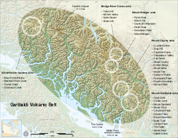
Bridge River Cones
Encyclopedia
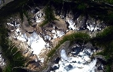
The Bridge River Cones, sometimes referred to as the Lillooet Cones and Salal Creek Cones, is the name given to a volcanic field
located on the north flank of the upper Bridge River
, about 40 km (25 mi) west of the town of Gold Bridge
. The cones are in the lee of the Lillooet Icecap
and sit astride a group of passes between the Bridge River, which flows W-E to their south, and the Lord River, which flows north to the Taseko Lakes
in the Chilcotin District
.
ic and basalt
ic eruptive centers. Sham Hill
(50.90°N 123.51°W), a 60 m (197 ft) high steep-sided volcanic plug
, is the oldest volcano in the field with a potassium-argon date
of one million years. The plug is approximately 300 m (984 ft) wide and its bare glaciated surface, strewn with glacial erratic
s, consists of large subhorizontal columns formed within the central conduit of an eroded stratovolcano
.
The Salal Glacier volcanic complex
(50.79°N 123.38°W), with a potassium-argon date of 0.97 to 0.59 million years, contains subaerial tephra and thin scoriaceous flows in the upper part of the pile are surrounded by ice-ponded flows up to 100 m (328 ft) thick.
Tuber Hill
(50.93°N 123.44°W), a small basaltic stratovolcano with a potassium-argon date of 0.6 million years, was constructed on the Bridge River upland when neighboring valleys were filled by ice. Where distal flows violated on the glaciers a marginal meltwater lake was created in which less than 150 m (492 ft) of interbedded hyaloclastite
, debris flow
s, and lacustrine tuff
were depositied.
The youngest volcanic rocks in the Bridge River volcanic field lie east of Tuber Hill and are remnants of valley-filling basalt flows. The age of these valley-filling basalt flows is unknown but the presence of unconsolidated glacial till under the flows suggest they are less than 1,500 years old.
Volcanic field
A volcanic field is an area of the Earth's crust that is prone to localized volcanic activity. They usually contain 10 to 100 volcanoes, such as cinder cones and are usually in clusters. Lava flows may also occur...
located on the north flank of the upper Bridge River
Bridge River
The Bridge River is, or was, a major tributary of British Columbia's Fraser River, entering that stream about six miles upstream from the town of Lillooet.-Name:Its name in the Lillooet language is Xwisten , sometimes spelled Nxwisten or Nxo-isten)...
, about 40 km (25 mi) west of the town of Gold Bridge
Gold Bridge, British Columbia
Gold Bridge is an unincorporated community in the Bridge River Country of British Columbia, Canada. Although numbering only around 250 inhabitants, Gold Bridge is the service and supply centre for the upper basin of the Bridge River Valley, which includes recreation-residential areas at the Gun...
. The cones are in the lee of the Lillooet Icecap
Lillooet Icecap
The Lillooet Icecap, also called the Lillooet Icefield or the Lillooet Crown, is a large icefield in the Pacific Ranges of the Coast Mountains in southwestern British Columbia, Canada. It is about northwest of the towns of Pemberton and Whistler, and about north of Vancouver, British Columbia...
and sit astride a group of passes between the Bridge River, which flows W-E to their south, and the Lord River, which flows north to the Taseko Lakes
Taseko Lakes
The Taseko Lakes are a pair of lakes, Upper Taseko Lake and Lower Taseko Lake, which are expansions of the upper Taseko River in the southern Chilcotin District of the Central Interior of British Columbia, Canada...
in the Chilcotin District
Chilcotin District
The Chilcotin District of British Columbia is usually known simply as "the Chilcotin", and also in speech commonly as "the Chilcotin Country" or simply Chilcotin. It is a plateau and mountain region in British Columbia on the inland lea of the Coast Mountains on the west side of the Fraser River....
.
Geology
The Bridge River Cones consist of small trachybasaltTrachybasalt
Trachybasalt is a volcanic rock with a composition between trachyte and basalt. Minerals included in trachybasalt include alkali feldspar, calcic plagioclase, olivine, clinopyroxene and likely very small amounts of leucite or analcime. It contains high alkali content ....
ic and basalt
Basalt
Basalt is a common extrusive volcanic rock. It is usually grey to black and fine-grained due to rapid cooling of lava at the surface of a planet. It may be porphyritic containing larger crystals in a fine matrix, or vesicular, or frothy scoria. Unweathered basalt is black or grey...
ic eruptive centers. Sham Hill
Sham Hill
Sham Hill is a volcanic plug in the Pacific Ranges of the Coast Mountains in southwestern British Columbia, Canada, located near the upper Bridge River. It is part of a volcanic group called the Bridge River Cones which in turn is part of the Garibaldi Volcanic Belt of the Cascade Volcanic Arc....
(50.90°N 123.51°W), a 60 m (197 ft) high steep-sided volcanic plug
Volcanic plug
A volcanic plug, also called a volcanic neck or lava neck, is a volcanic landform created when magma hardens within a vent on an active volcano. When forming, a plug can cause an extreme build-up of pressure if volatile-charged magma is trapped beneath it, and this can sometimes lead to an...
, is the oldest volcano in the field with a potassium-argon date
Potassium-argon dating
Potassium–argon dating or K–Ar dating is a radiometric dating method used in geochronology and archeology. It is based on measurement of the product of the radioactive decay of an isotope of potassium into argon . Potassium is a common element found in many materials, such as micas, clay minerals,...
of one million years. The plug is approximately 300 m (984 ft) wide and its bare glaciated surface, strewn with glacial erratic
Glacial erratic
A glacial erratic is a piece of rock that differs from the size and type of rock native to the area in which it rests. "Erratics" take their name from the Latin word errare, and are carried by glacial ice, often over distances of hundreds of kilometres...
s, consists of large subhorizontal columns formed within the central conduit of an eroded stratovolcano
Stratovolcano
A stratovolcano, also known as a composite volcano, is a tall, conical volcano built up by many layers of hardened lava, tephra, pumice, and volcanic ash. Unlike shield volcanoes, stratovolcanoes are characterized by a steep profile and periodic, explosive eruptions...
.
The Salal Glacier volcanic complex
Salal Glacier volcanic complex
The Salal Glacier volcanic complex is a complex volcano in the Pacific Ranges of the Coast Mountains in southwestern British Columbia, Canada, located near the upper Bridge River...
(50.79°N 123.38°W), with a potassium-argon date of 0.97 to 0.59 million years, contains subaerial tephra and thin scoriaceous flows in the upper part of the pile are surrounded by ice-ponded flows up to 100 m (328 ft) thick.
Tuber Hill
Tuber Hill
Tuber Hill is a small 600,000 year old basaltic stratovolcano that was constructed on the Bridge River highlands when nearby valleys were packed with ice...
(50.93°N 123.44°W), a small basaltic stratovolcano with a potassium-argon date of 0.6 million years, was constructed on the Bridge River upland when neighboring valleys were filled by ice. Where distal flows violated on the glaciers a marginal meltwater lake was created in which less than 150 m (492 ft) of interbedded hyaloclastite
Hyaloclastite
Hyaloclastite is a hydrated tuff-like breccia rich in black volcanic glass, formed during volcanic eruptions under water, under ice or where subaerial flows reach the sea or other bodies of water. It has the appearance of angular flat fragments sized between a millimeter to few centimeters...
, debris flow
Debris flow
A debris flow is a fast moving, liquefied landslide of unconsolidated, saturated debris that looks like flowing concrete. It is differentiated from a mudflow in terms of the viscosity and textural properties of the flow. Flows can carry material ranging in size from clay to boulders, and may...
s, and lacustrine tuff
Tuff
Tuff is a type of rock consisting of consolidated volcanic ash ejected from vents during a volcanic eruption. Tuff is sometimes called tufa, particularly when used as construction material, although tufa also refers to a quite different rock. Rock that contains greater than 50% tuff is considered...
were depositied.
The youngest volcanic rocks in the Bridge River volcanic field lie east of Tuber Hill and are remnants of valley-filling basalt flows. The age of these valley-filling basalt flows is unknown but the presence of unconsolidated glacial till under the flows suggest they are less than 1,500 years old.
See also
- Bridge River Power ProjectBridge River Power ProjectThe Bridge River Power Project is a hydroelectric power development in the Canadian province of British Columbia, located in the Lillooet Country between Whistler and Lillooet...
- Bridge River, British ColumbiaBridge River, British ColumbiaBridge River was used to describe three separate towns or localities in the Lillooet Country of the Interior of British Columbia connected with the river and valley of the same name.-1858-60:...
- Bridge River Indian BandBridge River Indian BandThe Bridge River Indian Band also known as the Nxwísten First Nation, the Xwisten First Nation, and the Bridge River Band, is a First Nations government located in the Central Interior-Fraser Canyon region of the Canadian province of British Columbia...
- Bridge River Canyon
- Bridge River CountryBridge River CountryThe Bridge River Country is a historic geographic region and mining district in the Interior of British Columbia, Canada, lying between the Fraser Canyon and the valley of the Lillooet River, south of the Chilcotin Plateau and north of the Lillooet Ranges...
- Garibaldi Volcanic BeltGaribaldi Volcanic BeltThe Garibaldi Volcanic Belt, also called the Canadian Cascade Arc, is a northwest-southeast trending volcanic chain in the Pacific Ranges of the Coast Mountains that extends from Watts Point in the south to the Ha-Iltzuk Icefield in the north. This chain of volcanoes is located in southwestern...
- Cascade VolcanoesCascade VolcanoesThe Cascade Volcanoes are a number of volcanoes in a volcanic arc in western North America, extending from southwestern British Columbia through Washington and Oregon to Northern California, a distance of well over 700 mi ...
- Cascade RangeCascade RangeThe Cascade Range is a major mountain range of western North America, extending from southern British Columbia through Washington and Oregon to Northern California. It includes both non-volcanic mountains, such as the North Cascades, and the notable volcanoes known as the High Cascades...
- Spruce Lake Protected AreaSpruce Lake Protected AreaThe Spruce Lake Protected Area, was a 71,347-hectare Protected Area in the British Columbia provincial parks system 200 km north of Vancouver. The area had been the subject of an ongoing preservationist controversy since the 1930s. Formerly known variously as the Southern Chilcotin Mountains...
- Ts'il?os Provincial ParkTs'il?os Provincial ParkTs'il?os Provincial Park is a provincial park in British Columbia, Canada. Ts'il?os is the official BC Parks designation for this provincial park, though sometimes it is written as "Ts'il-os", "Ts'yl-os", or "Tsylos"...
- Lillooet IcecapLillooet IcecapThe Lillooet Icecap, also called the Lillooet Icefield or the Lillooet Crown, is a large icefield in the Pacific Ranges of the Coast Mountains in southwestern British Columbia, Canada. It is about northwest of the towns of Pemberton and Whistler, and about north of Vancouver, British Columbia...
- List of volcanoes in Canada
- Volcanism of Canada
- Volcanism of Western CanadaVolcanism of Western CanadaVolcanism of Western Canada produces lava flows, lava plateaus, lava domes, cinder cones, stratovolcanoes, shield volcanoes, submarine volcanoes, calderas, diatremes and maars, along with examples of more less common volcanic forms such as tuyas and subglacial mounds.-Volcanic belts:*Anahim...
External links
- "NASA/JPL satellite images" location only