

The Volcano (British Columbia)
Encyclopedia
The Volcano, also known as Lava Fork volcano, is a small cinder cone
in the Boundary Ranges
of the Coast Mountains
in northwestern British Columbia
, Canada
. It is located approximately 60 km (37.3 mi) northwest of the small community of Stewart
near the head of Lava Fork
. With a summit elevation of 1330 m (4,363.5 ft) and a topographic prominence
of 311 m (1,020.3 ft), it rises above the surrounding rugged landscape on a remote mountain ridge that represents the northern flank of a glaciated U-shaped valley
.
Lava Fork volcano is associated with a small group of related volcanoes called the Iskut-Unuk River Cones
. This forms part of the much larger Northern Cordilleran Volcanic Province
, which extends from the Alaska
–Yukon
border to near Prince Rupert, British Columbia
. Eruptive activity at The Volcano is relatively young compared to most other volcanoes in the Northern Cordilleran Volcanic Province. Geologic studies have shown that The Volcano and its eruptive products were emplaced in the past 400 years; this is well after the last glacial period, which ended about 10,000 years ago.
, as well as the most recent to erupt. Its structure is poorly formed and has been reduced by erosion
from alpine glacial ice found at its elevation and latitude. It represents one of the few historically active volcanoes in the Northern Cordilleran Volcanic Province, with a base elevation estimated to be 100 m (328.1 ft). Like most cinder cones, The Volcano consists of a pile of loose volcanic ash
, lapilli
-sized tephra
and volcanic bomb
s. These were deposited during periods of lava fountain
activity. The vent area contains volcanic bombs up to 0.5 m (1.6 ft) long and small deposits of sulfur
precipitated from volcanic gas
es.
Like other Iskut-Unuk River Cones, The Volcano has its origins in continent
al rift
ing—a long rupture in the Earth's crust
where the lithosphere
is being pulled apart. This incipient rifting has formed as a result of the Pacific Plate
sliding northward along the Queen Charlotte Fault
, on its way to the Aleutian Trench
. As the continental crust
stretches, the near surface rocks fracture along steeply dipping cracks parallel to the rift known as faults. Basalt
ic magma
rises along these fractures to create effusive eruption
s. The rift zone has existed for at least 14.9 million years, and has created the Northern Cordilleran Volcanic Province. Several dormant volcanoes in the province
are potentially active, with The Volcano being one of the three having erupted in the last few hundred years. Tseax Cone
, which last erupted in the 18th century, is the southernmost volcano in the province, while Prindle Volcano in easternmost-central Alaska, which erupted more than 10,000 years ago, is generally considered the northernmost.
 At least two phases of volcanic activity have been identified at The Volcano. Each event was followed by the eruption of lengthy basaltic lava
flows that flowed down steep granitic
flanks of the mountain ridge on which The Volcano lies. After this took place, they travelled through the Lava Fork valley for 5 km (3 mi). Here, the flows crossed the British Columbia border into the U.S. state of Alaska and blocked the Blue River, a tributary
of the Unuk River
, forming several lakes. The lava flows in total are about 22 km (13.7 mi) long and still contain their original features from when they cooled, including pressure ridges
and lava channel
s. A series of large trees were engulfed by the lava flows during eruption. The bases of the trees burned and the upper trunks and branches collapsed into the solidifing lava, leaving the trees embedded on the surface of the lava flows. After the flows solidified, tree molds and lava tube
s collapsed to form volcanic pits. At the southern end of one of the lava flows, it spreads into a broad terminal lobe on the flat alluvial plain
of the Unuk River. Volcanic ash and lava from The Volcano still linger on small glacier
s near Mount Lewis Cass, a 2094 m (6,870.1 ft) high mountain near the Alaska-British Columbia border.
At least one lava flow from The Volcano was notified by a surveyor named Fremont Morse in 1905 during a survey for the International Boundary Commission. In 1906, Morse wrote that the most recently erupted lava flow had "probably occurred within less than fifty years". Since Morse's report, tree ring
and radiocarbon dating
techniques have been used to establish the dates of The Volcano's two volcanic phases. The first is estimated to have occurred about 360 years ago and the latest possibly took place only 150 years ago. This indicates that The Volcano is the youngest known volcanic mountain in Canada and that its volcanic activity is recent compared to many other volcanoes in British Columbia. In several documents, the last eruption of The Volcano is written to have occurred in 1904. However, according to the Smithsonian Institution
's Global Volcanism Program
, this eruption is considered uncertain.
Although The Volcano is estimated to have last erupted 150 years ago, it is one of the five volcanoes in the Northern Cordilleran Volcanic Province that have recorded seismicity since 1985. Others include Castle Rock
(two events), Hoodoo Mountain
(eight events), Crow Lagoon
(four events) and the Mount Edziza volcanic complex
(eight events). Seismic data suggest that these volcanoes still contain active magma chamber
s, indicating that some Northern Cordilleran volcanoes are probably active, with significant potential hazards. The seismic activity corresponds both with some of Canada's recently formed volcanoes and with persistent volcanoes that have had major explosive activity throughout their history, such as Hoodoo Mountain and the Mount Edziza volcanic complex.
of the same name. The reason for this controversy is because The Volcano is generic. In speech it may not be obvious whether The Volcano or the volcano is intended, leading to confusion. Similar named volcanoes in Canada include Volcano Vent
in the Tuya volcanic field
of northwestern British Columbia and Volcano Mountain
in the Fort Selkirk volcanic field
of central Yukon
. As of 2009, the unofficial terms for The Volcano continue to be used by Natural Resources Canada
.
are protected in Lava Forks Provincial Park
. Founded in 2001 as a Class A provincial park
, this highly remote park
covers an area of 7000 ha (17,297.4 acre). Lying within its boundaries are the Lava Lakes
, two lakes dammed by lava flows erupted from The Volcano. Located in asserted traditional territory of the Tahltan First Nation
, Lava Forks Provincial Park provides a location to study ecological processes associated with primary succession or the establishment of vegetation after a major disturbance. After 150 years of non-eruptive activity, vegetation has grown on the surface of the lava flows, including moss
es and lichen
s. Western Hemlock, Mountain Hemlock and Alpine tundra
biogeoclimatic subzones also occur in the area, which form part of the Boundary Ranges Ecosection.
Like other Iskut-Unuk River Cones, The Volcano is not monitored closely enough by the Geological Survey of Canada to ascertain how active its magma system is. This is partly because it is located in a remote region and no major eruptions have occurred in Canada in the past few hundred years. As a result, volcano monitoring is less important than dealing with other natural processes, including tsunami
s, earthquake
s and landslide
s. However, with the existence of earthquakes, further volcanism is expected and would probably have effects on the surrounding landscape. Because of these concerns, significant support from Canadian university scientists have resulted in the construction of a baseline of knowledge on the state of volcanoes in Canada.
less extreme and is therefore not very hazardous. Ash and rock fragments (tephra) ejected during lava fountain activity are unlikely to be high enough to disrupt regional air traffic. However, they could possibly endanger lower flying aircraft along the northern coastal corridor between Vancouver
and Alaska. The closest major air route is about 170 km (105.6 mi) to the east. Volcanic ash reduces visibility and can cause jet engine failure, as well as damage to other aircraft systems.
Lava flows emitted during future volcanic eruptions would likely be basaltic in nature based on the composition of its lavas produced during past volcanic activity. Basaltic lava flows are low in silica content and can have speeds extending from 15 kilometre per hour. The last eruption at The Volcano 150 years ago had a large impact on fish, plant and animal inhabitants in the valley the lava flows travelled through to cross the Canada – United States border. Because of these circumstances, future eruptions may again block the flow of local water courses if the volume of the erupted lavas are significant enough. This would again have disastrous consequences for fish habitats and spawning grounds. However, there are neither records of any impacts on people during this eruption, nor evidence that it was even witnessed by people. A repeat of wildfire
s in the Lava Fork valley is also a possibility due to the existence of vegetation on and around the erupted lavas.
Cinder cone
According to the , Cinder Cone is the proper name of 1 cinder cone in Canada and 7 cinder cones in the United States:In Canada: Cinder Cone In the United States:...
in the Boundary Ranges
Boundary Ranges
The Boundary Ranges, also known in the singular and as the Alaska Boundary Range, are the largest and most northerly subrange of the Coast Mountains...
of the Coast Mountains
Coast Mountains
The Coast Mountains are a major mountain range, in the Pacific Coast Ranges, of western North America, extending from southwestern Yukon through the Alaska Panhandle and virtually all of the Coast of British Columbia. They are so-named because of their proximity to the sea coast, and are often...
in northwestern British Columbia
British Columbia
British Columbia is the westernmost of Canada's provinces and is known for its natural beauty, as reflected in its Latin motto, Splendor sine occasu . Its name was chosen by Queen Victoria in 1858...
, Canada
Canada
Canada is a North American country consisting of ten provinces and three territories. Located in the northern part of the continent, it extends from the Atlantic Ocean in the east to the Pacific Ocean in the west, and northward into the Arctic Ocean...
. It is located approximately 60 km (37.3 mi) northwest of the small community of Stewart
Stewart, British Columbia
Stewart is a small town, incorporated as a district municipality at the head of the Portland Canal in northwestern British Columbia, Canada. In 2006, its population was about 496.-History:...
near the head of Lava Fork
Lava Fork
Lava Fork is a creek in northwestern British Columbia, Canada and of the Alaska Panhandle, United States. It lies west of the Unuk River and northwest of Stewart...
. With a summit elevation of 1330 m (4,363.5 ft) and a topographic prominence
Topographic prominence
In topography, prominence, also known as autonomous height, relative height, shoulder drop , or prime factor , categorizes the height of the mountain's or hill's summit by the elevation between it and the lowest contour line encircling it and no higher summit...
of 311 m (1,020.3 ft), it rises above the surrounding rugged landscape on a remote mountain ridge that represents the northern flank of a glaciated U-shaped valley
U-shaped valley
A U-shaped valley also known as a glacial trough is one formed by the process of glaciation. It has a characteristic U-shape, with steep, straight sides, and a flat bottom. Glaciated valleys are formed when a glacier travels across and down a slope, carving the valley by the action of scouring...
.
Lava Fork volcano is associated with a small group of related volcanoes called the Iskut-Unuk River Cones
Iskut-Unuk River Cones
The Iskut-Unuk River Cones are a group of eight small basaltic centres at the southern end of the Northern Cordilleran Volcanic Province in the Boundary Ranges of the Coast Mountains. The lava flows date back 70,000 years, but the subaerial vents produced cinder cones and lava flows that were...
. This forms part of the much larger Northern Cordilleran Volcanic Province
Northern Cordilleran volcanic province
The Northern Cordilleran Volcanic Province , formerly known as the Stikine Volcanic Belt, is a geologic province defined by the occurrence of Miocene to Holocene volcanoes in the Pacific Northwest of North America...
, which extends from the Alaska
Alaska
Alaska is the largest state in the United States by area. It is situated in the northwest extremity of the North American continent, with Canada to the east, the Arctic Ocean to the north, and the Pacific Ocean to the west and south, with Russia further west across the Bering Strait...
–Yukon
Yukon
Yukon is the westernmost and smallest of Canada's three federal territories. It was named after the Yukon River. The word Yukon means "Great River" in Gwich’in....
border to near Prince Rupert, British Columbia
Prince Rupert, British Columbia
Prince Rupert is a port city in the province of British Columbia, Canada. It is the land, air, and water transportation hub of British Columbia's North Coast, and home to some 12,815 people .-History:...
. Eruptive activity at The Volcano is relatively young compared to most other volcanoes in the Northern Cordilleran Volcanic Province. Geologic studies have shown that The Volcano and its eruptive products were emplaced in the past 400 years; this is well after the last glacial period, which ended about 10,000 years ago.
Geology
The Volcano is the southernmost of 10 volcanoes comprising the Iskut-Unuk River Cones volcanic fieldVolcanic field
A volcanic field is an area of the Earth's crust that is prone to localized volcanic activity. They usually contain 10 to 100 volcanoes, such as cinder cones and are usually in clusters. Lava flows may also occur...
, as well as the most recent to erupt. Its structure is poorly formed and has been reduced by erosion
Erosion
Erosion is when materials are removed from the surface and changed into something else. It only works by hydraulic actions and transport of solids in the natural environment, and leads to the deposition of these materials elsewhere...
from alpine glacial ice found at its elevation and latitude. It represents one of the few historically active volcanoes in the Northern Cordilleran Volcanic Province, with a base elevation estimated to be 100 m (328.1 ft). Like most cinder cones, The Volcano consists of a pile of loose volcanic ash
Volcanic ash
Volcanic ash consists of small tephra, which are bits of pulverized rock and glass created by volcanic eruptions, less than in diameter. There are three mechanisms of volcanic ash formation: gas release under decompression causing magmatic eruptions; thermal contraction from chilling on contact...
, lapilli
Lapilli
Lapilli is a size classification term for tephra, which is material that falls out of the air during a volcanic eruption or during some meteorite impacts. Lapilli means "little stones" in Latin. They are in some senses similar to ooids or pisoids in calcareous sediments.By definition lapilli range...
-sized tephra
Tephra
200px|thumb|right|Tephra horizons in south-central [[Iceland]]. The thick and light coloured layer at center of the photo is [[rhyolitic]] tephra from [[Hekla]]....
and volcanic bomb
Volcanic bomb
A volcanic bomb is a mass of molten rock larger than 65 mm in diameter, formed when a volcano ejects viscous fragments of lava during an eruption. They cool into solid fragments before they reach the ground. Because volcanic bombs cool after they leave the volcano, they do not have grains...
s. These were deposited during periods of lava fountain
Lava fountain
A lava fountain is a volcanic phenomenon in which lava is forcefully but non-explosively ejected from a crater, vent, or fissure. Lava fountains may reach heights of up to . They may occur as a series of short pulses, or a continuous jet of lava. They are commonly seen in Hawaiian eruptions.-See...
activity. The vent area contains volcanic bombs up to 0.5 m (1.6 ft) long and small deposits of sulfur
Sulfur
Sulfur or sulphur is the chemical element with atomic number 16. In the periodic table it is represented by the symbol S. It is an abundant, multivalent non-metal. Under normal conditions, sulfur atoms form cyclic octatomic molecules with chemical formula S8. Elemental sulfur is a bright yellow...
precipitated from volcanic gas
Volcanic gas
|250px|thumb|right|Image of the [[rhyolitic]] [[lava dome]] of [[Chaitén Volcano]] during its 2008-2010 eruption.Volcanic gases include a variety of substances given off by active volcanoes...
es.
Like other Iskut-Unuk River Cones, The Volcano has its origins in continent
Continent
A continent is one of several very large landmasses on Earth. They are generally identified by convention rather than any strict criteria, with seven regions commonly regarded as continents—they are : Asia, Africa, North America, South America, Antarctica, Europe, and Australia.Plate tectonics is...
al rift
Rift
In geology, a rift or chasm is a place where the Earth's crust and lithosphere are being pulled apart and is an example of extensional tectonics....
ing—a long rupture in the Earth's crust
Crust (geology)
In geology, the crust is the outermost solid shell of a rocky planet or natural satellite, which is chemically distinct from the underlying mantle...
where the lithosphere
Lithosphere
The lithosphere is the rigid outermost shell of a rocky planet. On Earth, it comprises the crust and the portion of the upper mantle that behaves elastically on time scales of thousands of years or greater.- Earth's lithosphere :...
is being pulled apart. This incipient rifting has formed as a result of the Pacific Plate
Pacific Plate
The Pacific Plate is an oceanic tectonic plate that lies beneath the Pacific Ocean. At 103 million square kilometres, it is the largest tectonic plate....
sliding northward along the Queen Charlotte Fault
Queen Charlotte Fault
The Queen Charlotte Fault is an active transform fault, located between the North American Plate and the Pacific Plate, Canada's equivalent of the San Andreas Fault. The Queen Charlotte Fault forms a triple junction on its south with the Cascadia subduction zone and the Explorer Ridge...
, on its way to the Aleutian Trench
Aleutian Trench
The Aleutian Trench is a subduction zone and oceanic trench which runs along the southern coastline of Alaska and the adjacent waters of northeastern Siberia off the coast of Kamchatka Peninsula. It is classified as a "marginal trench" in the east as it runs along the margin of the continent, and...
. As the continental crust
Continental crust
The continental crust is the layer of igneous, sedimentary, and metamorphic rocks which form the continents and the areas of shallow seabed close to their shores, known as continental shelves. This layer is sometimes called sial due to more felsic, or granitic, bulk composition, which lies in...
stretches, the near surface rocks fracture along steeply dipping cracks parallel to the rift known as faults. Basalt
Basalt
Basalt is a common extrusive volcanic rock. It is usually grey to black and fine-grained due to rapid cooling of lava at the surface of a planet. It may be porphyritic containing larger crystals in a fine matrix, or vesicular, or frothy scoria. Unweathered basalt is black or grey...
ic magma
Magma
Magma is a mixture of molten rock, volatiles and solids that is found beneath the surface of the Earth, and is expected to exist on other terrestrial planets. Besides molten rock, magma may also contain suspended crystals and dissolved gas and sometimes also gas bubbles. Magma often collects in...
rises along these fractures to create effusive eruption
Effusive eruption
An effusive eruption is a volcanic eruption characterized by the outpouring of lava onto the ground...
s. The rift zone has existed for at least 14.9 million years, and has created the Northern Cordilleran Volcanic Province. Several dormant volcanoes in the province
Geologic province
A geologic or geomorphic province is a spatial entity with common geologic or geomorphic attributes. A province may include a single dominant structural element such as a basin or a fold belt, or a number of contiguous related elements...
are potentially active, with The Volcano being one of the three having erupted in the last few hundred years. Tseax Cone
Tseax Cone
The Tseax Cone , also called the Tseax River Cone or alternately the Aiyansh Volcano, is a young cinder cone and adjacent lava flows associated with the Nass Ranges and the Northern Cordilleran Volcanic Province...
, which last erupted in the 18th century, is the southernmost volcano in the province, while Prindle Volcano in easternmost-central Alaska, which erupted more than 10,000 years ago, is generally considered the northernmost.
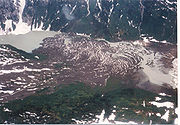
Volcanic history
Lava
Lava refers both to molten rock expelled by a volcano during an eruption and the resulting rock after solidification and cooling. This molten rock is formed in the interior of some planets, including Earth, and some of their satellites. When first erupted from a volcanic vent, lava is a liquid at...
flows that flowed down steep granitic
Granite
Granite is a common and widely occurring type of intrusive, felsic, igneous rock. Granite usually has a medium- to coarse-grained texture. Occasionally some individual crystals are larger than the groundmass, in which case the texture is known as porphyritic. A granitic rock with a porphyritic...
flanks of the mountain ridge on which The Volcano lies. After this took place, they travelled through the Lava Fork valley for 5 km (3 mi). Here, the flows crossed the British Columbia border into the U.S. state of Alaska and blocked the Blue River, a tributary
Tributary
A tributary or affluent is a stream or river that flows into a main stem river or a lake. A tributary does not flow directly into a sea or ocean...
of the Unuk River
Unuk River
The Unuk River is a river in the U.S. state of Alaska and the Canadian province of British Columbia. It flows from the Coast Mountains southwest to Behm Canal, northeast of Ketchikan, Alaska....
, forming several lakes. The lava flows in total are about 22 km (13.7 mi) long and still contain their original features from when they cooled, including pressure ridges
Pressure ridge (lava)
A pressure ridge is created in an active lava flow. Formation occurs when the outer edges and surfaces of the lava flow begin to harden. If the advancing lava underneath becomes restricted it may push up on the hardened crust, tilting it outward...
and lava channel
Lava channel
A lava channel is a stream of fluid lava contained within marginal zones of static lava or levees. The initial channel may not contain levees per se, until the parental flow solidifies over what develops into the channel and creates simple levees. This initial levee allows for the building of a...
s. A series of large trees were engulfed by the lava flows during eruption. The bases of the trees burned and the upper trunks and branches collapsed into the solidifing lava, leaving the trees embedded on the surface of the lava flows. After the flows solidified, tree molds and lava tube
Lava tube
Lava tubes are natural conduits through which lava travels beneath the surface of a lava flow, expelled by a volcano during an eruption. They can be actively draining lava from a source, or can be extinct, meaning the lava flow has ceased and the rock has cooled and left a long, cave-like...
s collapsed to form volcanic pits. At the southern end of one of the lava flows, it spreads into a broad terminal lobe on the flat alluvial plain
Alluvial plain
An alluvial plain is a relatively flat landform created by the deposition of sediment over a long period of time by one or more rivers coming from highland regions, from which alluvial soil forms...
of the Unuk River. Volcanic ash and lava from The Volcano still linger on small glacier
Glacier
A glacier is a large persistent body of ice that forms where the accumulation of snow exceeds its ablation over many years, often centuries. At least 0.1 km² in area and 50 m thick, but often much larger, a glacier slowly deforms and flows due to stresses induced by its weight...
s near Mount Lewis Cass, a 2094 m (6,870.1 ft) high mountain near the Alaska-British Columbia border.
At least one lava flow from The Volcano was notified by a surveyor named Fremont Morse in 1905 during a survey for the International Boundary Commission. In 1906, Morse wrote that the most recently erupted lava flow had "probably occurred within less than fifty years". Since Morse's report, tree ring
Dendrochronology
Dendrochronology or tree-ring dating is the scientific method of dating based on the analysis of patterns of tree-rings. Dendrochronology can date the time at which tree rings were formed, in many types of wood, to the exact calendar year...
and radiocarbon dating
Radiocarbon dating
Radiocarbon dating is a radiometric dating method that uses the naturally occurring radioisotope carbon-14 to estimate the age of carbon-bearing materials up to about 58,000 to 62,000 years. Raw, i.e. uncalibrated, radiocarbon ages are usually reported in radiocarbon years "Before Present" ,...
techniques have been used to establish the dates of The Volcano's two volcanic phases. The first is estimated to have occurred about 360 years ago and the latest possibly took place only 150 years ago. This indicates that The Volcano is the youngest known volcanic mountain in Canada and that its volcanic activity is recent compared to many other volcanoes in British Columbia. In several documents, the last eruption of The Volcano is written to have occurred in 1904. However, according to the Smithsonian Institution
Smithsonian Institution
The Smithsonian Institution is an educational and research institute and associated museum complex, administered and funded by the government of the United States and by funds from its endowment, contributions, and profits from its retail operations, concessions, licensing activities, and magazines...
's Global Volcanism Program
Global Volcanism Program
The Smithsonian Institution's Global Volcanism Program documents Earth's volcanoes and their eruptive history over the past 10,000 years. The GVP reports on current eruptions from around the world as well as maintaining a database repository on active volcanoes and their eruptions. In this way, a...
, this eruption is considered uncertain.
Although The Volcano is estimated to have last erupted 150 years ago, it is one of the five volcanoes in the Northern Cordilleran Volcanic Province that have recorded seismicity since 1985. Others include Castle Rock
Castle Rock (volcano)
Castle Rock is a volcanic neck located west of Iskut and 8 km northwest of Tuktsayda Mountain in British Columbia, Canada. It is part of the Pacific Ring of Fire that includes over 160 active volcanoes and is in the Klastline Group, Northern Cordilleran Volcanic Province and last erupted in...
(two events), Hoodoo Mountain
Hoodoo Mountain
Hoodoo Mountain is a potentially active flat-topped stratovolcano in the Stikine Country of northwestern British Columbia, Canada, located northeast of Wrangell, Alaska on the north side of the lower Iskut River and east of its junction with the Stikine River...
(eight events), Crow Lagoon
Crow Lagoon
Crow Lagoon is a little-known volcanic center located north of Prince Rupert, British Columbia, Canada. There are beds of thick, basaltic tephra that are of Holocene age....
(four events) and the Mount Edziza volcanic complex
Mount Edziza volcanic complex
The Mount Edziza volcanic complex is a large and potentially active north-south trending complex volcano in Stikine Country, northwestern British Columbia, Canada, located southeast of the small community of Telegraph Creek...
(eight events). Seismic data suggest that these volcanoes still contain active magma chamber
Magma chamber
A magma chamber is a large underground pool of molten rock found beneath the surface of the Earth. The molten rock in such a chamber is under great pressure, and given enough time, that pressure can gradually fracture the rock around it creating outlets for the magma...
s, indicating that some Northern Cordilleran volcanoes are probably active, with significant potential hazards. The seismic activity corresponds both with some of Canada's recently formed volcanoes and with persistent volcanoes that have had major explosive activity throughout their history, such as Hoodoo Mountain and the Mount Edziza volcanic complex.
Naming controversy
The name of the peak was suggested by an explorer named Chris Dickinson during the Cambridge Coast Mountains Expedition in 1979. It was adopted on November 24, 1980, and has been its official name since then. However, this name for the peak does not normally show up in any volcanological resources. Instead, it is informally referred to as Lava Fork or Lava Fork volcano due to its close association with the creekStream
A stream is a body of water with a current, confined within a bed and stream banks. Depending on its locale or certain characteristics, a stream may be referred to as a branch, brook, beck, burn, creek, "crick", gill , kill, lick, rill, river, syke, bayou, rivulet, streamage, wash, run or...
of the same name. The reason for this controversy is because The Volcano is generic. In speech it may not be obvious whether The Volcano or the volcano is intended, leading to confusion. Similar named volcanoes in Canada include Volcano Vent
Volcano Vent
Volcano Vent is a small shield volcano in northern British Columbia, Canada. It is Holocene in age and stands in relief above the surrounding area north of the Nazcha Creek and comprises the West Tuya lava field with West Vent and Grizzly Butte. It is one of the three small shield volcanoes in the...
in the Tuya volcanic field
Tuya Volcanic Field
The Tuya volcanic field is a volcanic field of tuyas located in far northern British Columbia, Canada, near the border with the Yukon Territory and focussed on the area of the Tuya Range, a subrange of the Stikine Ranges of the Cassiar Mountains, though some vents are in the Kawdy Plateau, the...
of northwestern British Columbia and Volcano Mountain
Volcano Mountain
Volcano Mountain is an active cinder cone in central Yukon Territory, Canada, located a short distance north of Fort Selkirk, near the confluence of the Pelly and Yukon Rivers...
in the Fort Selkirk volcanic field
Fort Selkirk Volcanic Field
The Fort Selkirk volcanic field is a monogenetic volcanic field in the Northern Cordilleran Volcanic Province, Yukon Territory, Canada. It is the northernmost Holocene age volcanic field in Canada, located close to the connection of the Yukon and Pelly rivers. The youngest eruptions within the...
of central Yukon
Yukon
Yukon is the westernmost and smallest of Canada's three federal territories. It was named after the Yukon River. The word Yukon means "Great River" in Gwich’in....
. As of 2009, the unofficial terms for The Volcano continue to be used by Natural Resources Canada
Natural Resources Canada
The Department of Natural Resources , operating under the FIP applied title Natural Resources Canada , is the ministry of the government of Canada responsible for natural resources, energy, minerals and metals, forests, earth sciences, mapping and remote sensing...
.
Protection and monitoring
The Volcano, its eruptive products and a large mineral springMineral spring
Mineral springs are naturally occurring springs that produce water containing minerals, or other dissolved substances, that alter its taste or give it a purported therapeutic value...
are protected in Lava Forks Provincial Park
Lava Forks Provincial Park
Lava Forks Provincial Park is a provincial park in northern British Columbia, Canada. It is the site of Canada's most recent volcanic eruption, which occurred in 1904 at Lava Fork .-See also:*Volcanism of Canada*Volcanism of Western Canada...
. Founded in 2001 as a Class A provincial park
Provincial park
A provincial park is a park under the management of a provincial or territorial government in Canada.While provincial parks are not the same as national parks, their workings are very similar...
, this highly remote park
Park
A park is a protected area, in its natural or semi-natural state, or planted, and set aside for human recreation and enjoyment, or for the protection of wildlife or natural habitats. It may consist of rocks, soil, water, flora and fauna and grass areas. Many parks are legally protected by...
covers an area of 7000 ha (17,297.4 acre). Lying within its boundaries are the Lava Lakes
Lava Lakes
The Lava Lakes are a group of small lakes at the head of Lava Fork in the Boundary Ranges of northwestern British Columbia, Canada.The Volcano, a cinder cone about north of the British Columbia-Alaska border on the eastern shore of the Lava Lakes, is the source for lava flows that overwhelm the...
, two lakes dammed by lava flows erupted from The Volcano. Located in asserted traditional territory of the Tahltan First Nation
Tahltan First Nation
The Tahltan First Nation, also known as the Tahltan Indian Band, is a band government of the Tahltan people. Their main community and reserves are located at Telegraph Creek, British Columbia. Their language is the Tahltan language, which is an Athabaskan language also known as Nahanni, is...
, Lava Forks Provincial Park provides a location to study ecological processes associated with primary succession or the establishment of vegetation after a major disturbance. After 150 years of non-eruptive activity, vegetation has grown on the surface of the lava flows, including moss
Moss
Mosses are small, soft plants that are typically 1–10 cm tall, though some species are much larger. They commonly grow close together in clumps or mats in damp or shady locations. They do not have flowers or seeds, and their simple leaves cover the thin wiry stems...
es and lichen
Lichen
Lichens are composite organisms consisting of a symbiotic organism composed of a fungus with a photosynthetic partner , usually either a green alga or cyanobacterium...
s. Western Hemlock, Mountain Hemlock and Alpine tundra
Alpine tundra
Alpine tundra is a natural region that does not contain trees because it is at high altitude. Alpine tundra is distinguished from arctic tundra, because alpine soils are generally better drained than arctic soils...
biogeoclimatic subzones also occur in the area, which form part of the Boundary Ranges Ecosection.
Like other Iskut-Unuk River Cones, The Volcano is not monitored closely enough by the Geological Survey of Canada to ascertain how active its magma system is. This is partly because it is located in a remote region and no major eruptions have occurred in Canada in the past few hundred years. As a result, volcano monitoring is less important than dealing with other natural processes, including tsunami
Tsunami
A tsunami is a series of water waves caused by the displacement of a large volume of a body of water, typically an ocean or a large lake...
s, earthquake
Earthquake
An earthquake is the result of a sudden release of energy in the Earth's crust that creates seismic waves. The seismicity, seismism or seismic activity of an area refers to the frequency, type and size of earthquakes experienced over a period of time...
s and landslide
Landslide
A landslide or landslip is a geological phenomenon which includes a wide range of ground movement, such as rockfalls, deep failure of slopes and shallow debris flows, which can occur in offshore, coastal and onshore environments...
s. However, with the existence of earthquakes, further volcanism is expected and would probably have effects on the surrounding landscape. Because of these concerns, significant support from Canadian university scientists have resulted in the construction of a baseline of knowledge on the state of volcanoes in Canada.
Volcanic hazards
At least seven eruptions have occurred in the Iskut-Unuk River volcanic field in the past 10,000 years. Since around 1600 all eruptions have occurred at The Volcano. Its total eruption volume is estimated to be 2.2 km³ (0.527808068929431 cu mi). Future eruptions from The Volcano will probably be similar in character to those that have occurred throughout its 360-year eruptive history. There is a one in 200 chance per year of an eruption occurring in Canada and one in 220 chance per year of an effusive eruption. An eruption in the foreseeable future is probably more likely along the Northern Cordilleran Volcanic Province than in an unrelated volcanic zone outside the province. This is because the Northern Cordilleran Volcanic Province, which includes the Iskut-Unuk River Cones, is the most active volcanic zone in Canada.Effects
A small range of effects are expected from future eruptions at The Volcano. Its remote uninhabited location makes volcanic hazardsVolcanic hazards
Volcanic hazards are threats to life and/or infrastructure due to volcanic activity and related phenomena such as floods and landslides at volcanoes.-Lava flows:...
less extreme and is therefore not very hazardous. Ash and rock fragments (tephra) ejected during lava fountain activity are unlikely to be high enough to disrupt regional air traffic. However, they could possibly endanger lower flying aircraft along the northern coastal corridor between Vancouver
Vancouver
Vancouver is a coastal seaport city on the mainland of British Columbia, Canada. It is the hub of Greater Vancouver, which, with over 2.3 million residents, is the third most populous metropolitan area in the country,...
and Alaska. The closest major air route is about 170 km (105.6 mi) to the east. Volcanic ash reduces visibility and can cause jet engine failure, as well as damage to other aircraft systems.
Lava flows emitted during future volcanic eruptions would likely be basaltic in nature based on the composition of its lavas produced during past volcanic activity. Basaltic lava flows are low in silica content and can have speeds extending from 15 kilometre per hour. The last eruption at The Volcano 150 years ago had a large impact on fish, plant and animal inhabitants in the valley the lava flows travelled through to cross the Canada – United States border. Because of these circumstances, future eruptions may again block the flow of local water courses if the volume of the erupted lavas are significant enough. This would again have disastrous consequences for fish habitats and spawning grounds. However, there are neither records of any impacts on people during this eruption, nor evidence that it was even witnessed by people. A repeat of wildfire
Wildfire
A wildfire is any uncontrolled fire in combustible vegetation that occurs in the countryside or a wilderness area. Other names such as brush fire, bushfire, forest fire, desert fire, grass fire, hill fire, squirrel fire, vegetation fire, veldfire, and wilkjjofire may be used to describe the same...
s in the Lava Fork valley is also a possibility due to the existence of vegetation on and around the erupted lavas.
See also
- Iskut Canyon ConeIskut Canyon ConeIskut Canyon Cone, also known as Iskut River Cone, is a cinder cone of the Iskut-Unuk River Cones group in northwestern British Columbia, Canada, located on the steep southern flank of the Iskut valley near its junction with Forrest Kerr Creek...
- Cinder MountainCinder MountainCinder Mountain is a partly eroded cinder cone at the head of Snippaker Creek, British Columbia, Canada. It is one of the Iskut-Unuk River Cones and is the source of a basaltic lava flow that extends north into Copper King Creek. An isolated pile of subaerial basalt flows and associated pillow...
- Cone Glacier VolcanoCone Glacier VolcanoCone Glacier Volcano is a cinder cone in the Boundary Ranges of the Coast Mountains in northwestern British Columbia, Canada. It is part of the Iskut-Unuk River Cones group and last erupted during the Holocene period...
- King Creek ConeKing Creek ConeKing Creek Cone is a subglacial mound of the Iskut-Unuk River Cones group in northwestern British Columbia, Canada. It last erupted during the Pleistocene epoch.-See also:*List of volcanoes in Canada*List of Northern Cordilleran volcanoes...
- Seconed Canyon ConeSeconed Canyon ConeSeconed Canyon Cone, also called Canyon Creek Cone is a cinder cone in the Boundary Ranges of the Coast Mountains in northwestern British Columbia, Canada...
- Snippaker Creek ConeSnippaker Creek ConeSnippaker Creek Cone is a cinder cone of the Iskut-Unuk River Cones group in northwestern British Columbia, Canada, located near the western flank of Cinder Mountain. It last erupted during the Holocene epoch.-See also:*List of volcanoes in Canada...
- Tom MacKay Creek ConeTom MacKay Creek ConeTom MacKay Creek Cone is a subglacial mound in northwestern British Columbia, Canada. It is part of the Iskut-Unuk River Cones group and last erupted during the Pleistocene epoch.-See also:*List of volcanoes in Canada*List of Northern Cordilleran volcanoes...
- List of Northern Cordilleran volcanoes
- List of volcanoes of Canada
- List of cinder cones
- Volcanism of Western CanadaVolcanism of Western CanadaVolcanism of Western Canada produces lava flows, lava plateaus, lava domes, cinder cones, stratovolcanoes, shield volcanoes, submarine volcanoes, calderas, diatremes and maars, along with examples of more less common volcanic forms such as tuyas and subglacial mounds.-Volcanic belts:*Anahim...
External links
- http://atlas.nrcan.gc.ca/site/english/maps/topo/map?mapsize=428%20380&lat=56.4230555572&long=-130.850277778&mapxy=-2050597.26864+1409677.68319&scale=5000000&feature_na=The+Volcano&location1=59&unique_key=0cfbc10f849c20c3b586d59c26bf9ab2&searchstring=The%20Volcano&entity=MTN&layers=fapfeature+fapfeature%20north_arrow%20other_features%20million_grid%20t50k_grid%20grid_50k_3%20roads%20hydrography%20boundary%20builtup%20vegetation%20populated_places%20railway%20power_network%20manmade_features%20designated_areas%20water_features%20water_saturated_soils%20relief%20contours%20toponymy%20contour%20nodata_ntdb_50k&urlappend=%26unique_key%3D0cfbc10f849c20c3b586d59c26bf9ab2%26map.layer%5Btextzoom03%5D%3DFEATURE+POINTS+-2050584.75982+1409665.43347+END+TEXT+%22The%2BVolcano%22+END%26map.layer%5Btextzoom46%5D%3DFEATURE+POINTS+-2050584.75982+1409665.43347+END+TEXT+%22The%2BVolcano%22+END%26map.layer%5Barrowzoom03%5D%3DFEATURE+POINTS+-2050584.75982+1409665.43347+END+END"The Volcano"]. Atlas of CanadaAtlas of CanadaThe Atlas of Canada is an Internet atlas published by Natural Resources Canada that has information on every city, town, village, and hamlet in Canada...
. Natural Resources Canada.