

Howe Sound
Encyclopedia


Sound (geography)
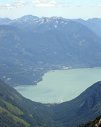
In geography a sound or seaway is a large sea or ocean inlet larger than a bay, deeper than a bight and wider than a fjord; or it may be defined as a narrow sea or ocean channel between two bodies of land ....
, actually a network of fjord
Fjord
Geologically, a fjord is a long, narrow inlet with steep sides or cliffs, created in a valley carved by glacial activity.-Formation:A fjord is formed when a glacier cuts a U-shaped valley by abrasion of the surrounding bedrock. Glacial melting is accompanied by rebound of Earth's crust as the ice...
s situated immediately northwest of Vancouver
Vancouver
Vancouver is a coastal seaport city on the mainland of British Columbia, Canada. It is the hub of Greater Vancouver, which, with over 2.3 million residents, is the third most populous metropolitan area in the country,...
.
Geography
Howe Sound's mouth at the Strait of GeorgiaStrait of Georgia
The Strait of Georgia or the Georgia Strait is a strait between Vancouver Island and the mainland coast of British Columbia, Canada. It is approximately long and varies in width from...
is situated between West Vancouver and the Sunshine Coast
Sunshine Coast, British Columbia
The Sunshine Coast is a region of the southern mainland coast of British Columbia, on the eastern shore of the Strait of Georgia, and just northwest of Greater Vancouver...
. The sound
Sound (geography)
In geography a sound or seaway is a large sea or ocean inlet larger than a bay, deeper than a bight and wider than a fjord; or it may be defined as a narrow sea or ocean channel between two bodies of land ....
is triangular shaped, open on its southeast towards the Strait of Georgia, and extends 42 kilometres to its head at Squamish
Squamish, British Columbia
Squamish is a community and a district municipality in the Canadian province of British Columbia, located at the north end of Howe Sound on the Sea to Sky Highway...
. There are several islands in the sound, three of which are large and mountainous in their own right. The steep-sided mainland shores funnel the breezes as the daily thermals build the wind to 20 knots plus at the northern end of the sound on a typical summer day. A small outcrop
Outcrop
An outcrop is a visible exposure of bedrock or ancient superficial deposits on the surface of the Earth. -Features:Outcrops do not cover the majority of the Earth's land surface because in most places the bedrock or superficial deposits are covered by a mantle of soil and vegetation and cannot be...
of volcanic rock
Volcanic rock
Volcanic rock is a rock formed from magma erupted from a volcano. In other words, it is an igneous rock of volcanic origin...
is located on the eastern shore of Howe Sound called the Watts Point volcanic centre
Watts Point volcanic centre
The Watts Point volcanic centre is a small outcrop of Pleistocene age volcanic rock at Watts Point in British Columbia, Canada, about south of Squamish and north of Vancouver, and just north of Britannia Beach. It is the southernmost volcanic zone in the Squamish volcanic field and of the...
.
History
The history of Howe Sound begins with the Indigenous people, the Squamish and ShishalhShishalh
The Shishalh people, at the time of the first European contact had a population near 26,000. Shishalh women were famous for their beautiful cedar woven baskets, using materials gathered from the roots of the cedar tree, cannery grass and birch bark for the design.The Sechelt First Nations...
, who roamed this land and traveled on this body of water for thousands of years, had village sites and camp sites spread throughout the area. The land and islands are still used by Squamish and Shishalh
Shishalh
The Shishalh people, at the time of the first European contact had a population near 26,000. Shishalh women were famous for their beautiful cedar woven baskets, using materials gathered from the roots of the cedar tree, cannery grass and birch bark for the design.The Sechelt First Nations...
for cultural practices. Both the Squamish Shishalh
Shishalh
The Shishalh people, at the time of the first European contact had a population near 26,000. Shishalh women were famous for their beautiful cedar woven baskets, using materials gathered from the roots of the cedar tree, cannery grass and birch bark for the design.The Sechelt First Nations...
are a part of the Coast Salish
Coast Salish
Coast Salish languages are a subgroup of the Salishan language family. These languages are spoken by First Nations or Native American peoples inhabiting the territory that is now the southwest coast of British Columbia around the Strait of Georgia and Washington state around Puget Sound...
linguistic and cultural groupings.
Spanish explorers observed the sound in 1791 and named it Boca del Carmelo. Captain George Vancouver
George Vancouver
Captain George Vancouver RN was an English officer of the British Royal Navy, best known for his 1791-95 expedition, which explored and charted North America's northwestern Pacific Coast regions, including the coasts of contemporary Alaska, British Columbia, Washington and Oregon...
entered the sound in 1792, and named it after Admiral Earl Howe
Richard Howe, 1st Earl Howe
Admiral of the Fleet Richard Howe, 1st Earl Howe KG was a British naval officer, notable in particular for his service during the American War of Independence and French Revolutionary Wars. He was the brother of William Howe and George Howe.Howe joined the navy at the age of thirteen and served...
..
In 1888, copper was discovered in the mountains around Britannia Creek, south of Squamish. Large scale mining began at Britannia Beach in 1905, and by 1929, the largest copper mine in the British Empire
British Empire
The British Empire comprised the dominions, colonies, protectorates, mandates and other territories ruled or administered by the United Kingdom. It originated with the overseas colonies and trading posts established by England in the late 16th and early 17th centuries. At its height, it was the...
was located here, beside the shores of Howe Sound. The mine closed in 1974, but part of its historical legacy has been the large amounts of toxic effluent it has deposited into Howe Sound.
Islands in Howe Sound
Passage IslandPassage Island (British Columbia)
Passage Island is a small island near West Vancouver, British Columbia and across from Bowen Island. The island is mostly woodland and cliffs. It marks the entrance to Howe Sound, and the ferry from Horseshoe Bay to Nanaimo regularly passes it...
marks the entrance to Howe Sound. It has a few year-round residents and spectacular views of Downtown Vancouver and Vancouver Island
Vancouver Island
Vancouver Island is a large island in British Columbia, Canada. It is one of several North American locations named after George Vancouver, the British Royal Navy officer who explored the Pacific Northwest coast of North America between 1791 and 1794...
. Ships entering Howe Sound will pass east or west of Passage Island.
Bowen Island
Bowen Island
Bowen Island, British Columbia, is an island municipality in Howe Sound, is part of the Greater Vancouver Regional District, and is an island included within the jurisdiction of the Islands Trust . Approximately 6 km wide by 12 km long, the island at its closest point is about 2 km...
is the most populous island and is nearest Vancouver
Vancouver
Vancouver is a coastal seaport city on the mainland of British Columbia, Canada. It is the hub of Greater Vancouver, which, with over 2.3 million residents, is the third most populous metropolitan area in the country,...
, being just opposite Horseshoe Bay. It is incorporated as an island municipality and is a member municipality of Metro Vancouver.
Gambier Island
Gambier Island
Gambier Island is an island located in Howe Sound near Vancouver, British Columbia. It is about 17,000 acres in size and is located about 10 km north of the Horseshoe Bay community and ferry terminal in westernmost West Vancouver....
is the largest of the Howe Sound islands, to the northwest of Bowen, near the Langdale
Langdale, British Columbia
Langdale is a small community on the Sunshine Coast of southern British Columbia. It is set in a verdant environment characteristic of many small BC communities. Its main feature is the BC Ferries terminal that links the Sunshine Coast to Vancouver via Horseshoe Bay, with connecting foot-passenger...
ferry landing. Gambier Island is in the process of some concentrated development along its eastern shores in Brigade Bay and Douglas Bay. Numerous seasonal homes line the shores of the southern bays (West Bay, Centre Bay, Port Graves, and Halkett Bay) along with several local yacht club outstations in both the southern and northern parts of the island. The western shore of Gambier and its adjacent Thornborough Channel is still largely taken up by log booms and forestry activity.
A third, smaller but extremely steep and conical island to the northeast of both is Anvil Island
Anvil Island
Anvil Island, also often called Hat Island, is the third-largest of the islands in Howe Sound, British Columbia, Canada, and the northernmost of the major islands in that sound. It is located northeast of Gambier Island and southwest of Britannia Beach and west of Porteau Cove. The Defence...
, also known as Hat Island. Anvil Island has a summer church camp as well as a number of seasonal homes, primarily in the southern bay formed by a prominent eastward projecting peninsula. The north facing bay of this peninsula is exposed to strong overnight and winter outflow northerly winds.

Plumper Cove Marine Provincial Park
Plumper Cove Marine Provincial Park is a provincial park in British Columbia, Canada. The park is located on Keats Island in Howe Sound, northwest of Vancouver, British Columbia....
. The island is serviced by water taxi from Langdale. There is a small core of permanent residents living in Eastbourne.
Between Keats and Bowen Islands lie the Pasley group, a cluster of privately owned islands, each with a scattering of seasonal homes. Further southeast lies Worlcombe Island, also seasonally inhabited.
Just north of Horseshoe Bay lies Bowyer Island
Bowyer Island
Bowyer Island is a small island in Howe Sound. It is located east of Bowen Island. BC Liberal politician, formerly Attorney-General of British Columbia, Geoff Plant is a seasonal resident.Bowyer Island was named by Capt...
, another steep sided island with seasonal homes along its south and west shores.
Uninhabited islands in the northern section of Howe Sound include the Defence Islands, a pair of rocky islands that comprise the Defence Islands Indian Reserves 28 and 28A.
Christie Islet and Pam Rocks just south of Anvil Island are recognized bird breeding sites and a great place to view seals sunning themselves. Pam Rocks is a reporting weather station for the marine weather system. Winter northerly gales can reach close to hurricane force here (see squamish wind).
Between Gambier Island and the Port Mellon mill lies Woolridge Island, privately owned with a single residence.
Transportation
British Columbia Highway 99 (the Sea-to-Sky Highway, also known as the Squamish Highway) runs along the east shore of Howe Sound, linking the Lower MainlandLower Mainland
The Lower Mainland is a name commonly applied to the region surrounding and including Vancouver, British Columbia, Canada. As of 2007, 2,524,113 people live in the region; sixteen of the province's thirty most populous municipalities are located there.While the term Lower Mainland has been...
to Lions Bay, Britannia Beach, Squamish
Squamish, British Columbia
Squamish is a community and a district municipality in the Canadian province of British Columbia, located at the north end of Howe Sound on the Sea to Sky Highway...
, where it then proceeds inland to Whistler
Whistler, British Columbia
Whistler is a Canadian resort town in the southern Pacific Ranges of the Coast Mountains in the province of British Columbia, Canada, approximately north of Vancouver...
and beyond. From 2007 to 2010, this highway was upgraded to what would ultimately become a mixture of four-lane divided sections, three lane sections with alternating passing lanes, and some improved two lane sections. The first section of Olympics-related improvements, between Horseshoe Bay and Lions Bay, opened in December 2005. Also following the east shore, and built before and below the highway, is the former British Columbia Railway which was recently sold by the provincial government to the Canadian National Railway Company. The Pacific Great Eastern Railway between Squamish
Squamish, British Columbia
Squamish is a community and a district municipality in the Canadian province of British Columbia, located at the north end of Howe Sound on the Sea to Sky Highway...
and Lillooet
Lillooet, British Columbia
Lillooet is a community on the Fraser River in western Canada, about up the British Columbia Railway line from Vancouver. Situated at an intersection of deep gorges in the lee of the Coast Mountains, it has a dry climate- of precipitation is recorded annually at the town's weather station,...
was constructed 1912-16, and Squamish became a busy place as a rail-port for freight and also burgeoning passenger traffic as lodges up the rail line became popular with weekenders from the city, who reached the railway via the MV Brittannia (now a tour boat). Railway connections to North Vancouver
North Vancouver, British Columbia
There are two municipalities in the Greater Vancouver region of British Columbia, Canada, that use the name North Vancouver. These are:*The City of North Vancouver...
were completed in the 1950s, with a highway built in the later 1960s that was the precursor to today's Sea-to-Sky Highway.
BC Ferries
BC Ferries
British Columbia Ferry Services Inc. or BC Ferries is a de facto Crown Corporation that provides all major passenger and vehicle ferry services for coastal and island communities in the Canadian province of British Columbia...
runs regularly scheduled ferry service between Horseshoe Bay and Langdale
Langdale, British Columbia
Langdale is a small community on the Sunshine Coast of southern British Columbia. It is set in a verdant environment characteristic of many small BC communities. Its main feature is the BC Ferries terminal that links the Sunshine Coast to Vancouver via Horseshoe Bay, with connecting foot-passenger...
and between Horseshoe Bay and Snug Cove on Bowen Island
Bowen Island
Bowen Island, British Columbia, is an island municipality in Howe Sound, is part of the Greater Vancouver Regional District, and is an island included within the jurisdiction of the Islands Trust . Approximately 6 km wide by 12 km long, the island at its closest point is about 2 km...
. There is also water taxi
Water taxi
A water taxi or water bus, also known as a commuter boat, is a watercraft used to provide public transport, usually but not always in an urban environment. Service may be scheduled with multiple stops, operating in a similar manner to a bus, or on demand to many locations, operating in a similar...
service from Horseshoe Bay and Langdale to Bowen Island, Gambier Island
Gambier Island
Gambier Island is an island located in Howe Sound near Vancouver, British Columbia. It is about 17,000 acres in size and is located about 10 km north of the Horseshoe Bay community and ferry terminal in westernmost West Vancouver....
and Keats Island.
Industry and towns
Squamish, British Columbia
Squamish is a community and a district municipality in the Canadian province of British Columbia, located at the north end of Howe Sound on the Sea to Sky Highway...
is a minor deepwater port. It was the original southern terminus of the BCR in the days when it was the Pacific Great Eastern, and had a busy ferry
Ferry
A ferry is a form of transportation, usually a boat, but sometimes a ship, used to carry primarily passengers, and sometimes vehicles and cargo as well, across a body of water. Most ferries operate on regular, frequent, return services...
terminal where travellers would disembark from ferries and steamers bringing them in from Vancouver
Vancouver
Vancouver is a coastal seaport city on the mainland of British Columbia, Canada. It is the hub of Greater Vancouver, which, with over 2.3 million residents, is the third most populous metropolitan area in the country,...
harbour. In the 1960s what was then called the Squamish Highway was finally pushed through from Vancouver. This made the former steamer service unnecessary. Once a thriving forestry town, with recent cutbacks in logging along with the closure and dismantling of a major sawmill in 2004, Squamish has become a tourist destination and a commuter community for workers in nearby Whistler and Vancouver. The recent closure of the Woodfibre pulp mill in 2006 signals an end to the resource based economy here. Squamish is a world centre for rock climbing, with the 1500' bulk of the Stawamus Chief
Stawamus Chief
The Stawamus Chief is a granite dome located adjacent to the town of Squamish, British Columbia. It towers over above the waters of nearby Howe Sound...
, a huge rock formation always busy with climbers, along with other formations overlooking downtown and the head of Howe Sound. In addition,the strong winds and flat waters at the upper end of Howe Sound have made Squamish a mecca for windsurfers, kite boarders and keelboat sailors.
Just south of town along Highway 99 is Shannon Falls
Shannon Falls Provincial Park
Shannon Falls Provincial Park is a provincial park in British Columbia, Canada. It is located from Vancouver and south of Squamish along the Sea to Sky Highway. Shannon Falls is the third highest waterfall in British Columbia....
, a popular tourist attraction and provincial park, and Darrell Bay
Darrell Bay
Darrell Bay is a bay and associated ferry terminal and unincorporated settlement on the northeast coast of Howe Sound to the south of Squamish, British Columbia, Canada. It is adjacent to Shannon Falls Provincial Park, which lies immediately across BC Highway 99...
, which is the ferry dock for service to the pulp mill at Woodfibre
Woodfibre, British Columbia
Woodfibre, originally Britannia West, was a pulp mill and at one time a small town, on the west side of upper Howe Sound near Squamish, British Columbia. The mill closed in March 2006.-History:...
, across the sound. Woodfibre
Woodfibre, British Columbia
Woodfibre, originally Britannia West, was a pulp mill and at one time a small town, on the west side of upper Howe Sound near Squamish, British Columbia. The mill closed in March 2006.-History:...
has no road access. From the early 1900s until 1973 there was a small company town surrounding the mill where most employees lived. By 1975 all employees had relocated, mostly to Squamish, and the town was dismantled. Over the next 30 years the mill slowly expanded into the former townsite, but it closed in early 2006.
Porteau Cove
Porteau Cove Provincial Park
Porteau Cove Provincial Park is a provincial park in British Columbia, Canada.Porteau Cove is located on the Howe Sound fjord, 38 km north of Vancouver on the Sea-to-Sky Highway, 20 km south of Squamish, 8.5 km south of Britannia Beach...
is a provincial campsite and also a location for scuba diving, as artificial reefs have been sunk in the area. The bluffs above the highway in this area are one of the main avalanche hazards to both the highway and the rail line, which are squeezed together between the foot of the bluffs and the shoreline.
Furry Creek is the location of a new upscale golf course and resort development. Proposals have called for a new highway from Vancouver via the Capilano River
Capilano River
The Capilano River flows from north to south through the Coast Mountains on Vancouver's North Shore and empties into Burrard Inlet, opposite Stanley Park. The river is one of three primary sources of drinking water for residents of Greater Vancouver. The Cleveland Dam, built in 1954, impounds a...
watershed would emerge on Highway 99 at Furry Creek. However, the fact that this route traverses the Lower Mainland's Capilano watershed creates nearly insurmountable political obstacles to its construction.
Lions Bay is a small residential community, incorporated as a village, climbing the mountainside from Howe Sound up to the west peak of the pair of summits known as The Lions
The Lions
In geography, The Lions are located in the North Shore Mountains north of Vancouver, British Columbia, Canada.The service organization Lions Clubs International is often referred to as "The Lions."...
, which overlook Vancouver on the other side.
Near Squamish
Squamish, British Columbia
Squamish is a community and a district municipality in the Canadian province of British Columbia, located at the north end of Howe Sound on the Sea to Sky Highway...
is Britannia Beach
Britannia Beach, British Columbia
Britannia Beach is a small unincorporated community in the Squamish-Lillooet Regional District located approximately 30 kilometers north of Vancouver, British Columbia on the Sea-to-Sky Highway on Howe Sound. It has a population of about 300....
, the former gold and copper mining town and port with some highway-based eateries and stores. Its name does not come directly from associations with Britain, but from the MV Britannia, the old Vancouver
Vancouver
Vancouver is a coastal seaport city on the mainland of British Columbia, Canada. It is the hub of Greater Vancouver, which, with over 2.3 million residents, is the third most populous metropolitan area in the country,...
-Squamish
Squamish, British Columbia
Squamish is a community and a district municipality in the Canadian province of British Columbia, located at the north end of Howe Sound on the Sea to Sky Highway...
steamer
Steamboat
A steamboat or steamship, sometimes called a steamer, is a ship in which the primary method of propulsion is steam power, typically driving propellers or paddlewheels...
(A new MV Britannia built in 1983 is in use as a tourboat based in Coal Harbour, Vancouver). Today the mine mill site is the popular Britannia Mine Museum, with mine shaft tours, gold panning etc. The prominent multi-story mine building underwent a restoration with the replacement of hundreds of window panes. The former mine site is also frequently used as a shooting site for a variety of TV and movie productions, most notably the popular X-Files TV series.
Horseshoe Bay is a residential and commercial district of Vancouver
Vancouver
Vancouver is a coastal seaport city on the mainland of British Columbia, Canada. It is the hub of Greater Vancouver, which, with over 2.3 million residents, is the third most populous metropolitan area in the country,...
on the southern edge of the Sea-to-Sky Highway. The highway clings to the cliffside above the BC Ferry
BC Ferries
British Columbia Ferry Services Inc. or BC Ferries is a de facto Crown Corporation that provides all major passenger and vehicle ferry services for coastal and island communities in the Canadian province of British Columbia...
terminal at Horseshoe Bay. Restaurants, tourist shops and galleries, a pub or two and recreational marinas are also situated in the community. Ferries from Horseshoe Bay, West Vancouver go to Departure Bay
Departure Bay, British Columbia
Departure Bay is a bay in central Nanaimo, British Columbia, on the east coast of Vancouver Island. The surrounding neighbourhood is also referred to as "Departure Bay"—once a settlement of its own, it was amalgamated into the City of Nanaimo in the 1970s .- Geography :The bay is framed to the...
in Nanaimo on Vancouver Island
Vancouver Island
Vancouver Island is a large island in British Columbia, Canada. It is one of several North American locations named after George Vancouver, the British Royal Navy officer who explored the Pacific Northwest coast of North America between 1791 and 1794...
, Bowen Island
Bowen Island
Bowen Island, British Columbia, is an island municipality in Howe Sound, is part of the Greater Vancouver Regional District, and is an island included within the jurisdiction of the Islands Trust . Approximately 6 km wide by 12 km long, the island at its closest point is about 2 km...
, and Langdale
Langdale, British Columbia
Langdale is a small community on the Sunshine Coast of southern British Columbia. It is set in a verdant environment characteristic of many small BC communities. Its main feature is the BC Ferries terminal that links the Sunshine Coast to Vancouver via Horseshoe Bay, with connecting foot-passenger...
on the Sunshine Coast
Sunshine Coast, British Columbia
The Sunshine Coast is a region of the southern mainland coast of British Columbia, on the eastern shore of the Strait of Georgia, and just northwest of Greater Vancouver...
, which is the ferry terminal for the southern Sunshine Coast.
The peninsula southwest of Horseshoe Bay, West Vancouver terminates at Whytecliffe, an upscale residential area and public park, which is the southern point of Howe Sound's east shore. South of here is the entrance of English Bay and Burrard Inlet
Burrard Inlet
Burrard Inlet is a relatively shallow-sided coastal fjord in southwestern British Columbia, Canada. Formed during the last Ice Age, it separates the City of Vancouver and the rest of the low-lying Burrard Peninsula from the slopes of the North Shore Mountains, home to the communities of West...
. Also in the vicinity of Howe Sound's mouth, at Point Atkinson is Lighthouse Park
Lighthouse Park
Lighthouse Park is a popular park in West Vancouver, Canada. Its area is about 75 hectares and it is almost completely covered with rugged, virgin rainforest. At the southermost tip of the peninsula is Point Atkinson with an impressive landmark lighthouse built in 1914 on granite boulders jutting...
.
Just north of Langdale
Langdale, British Columbia
Langdale is a small community on the Sunshine Coast of southern British Columbia. It is set in a verdant environment characteristic of many small BC communities. Its main feature is the BC Ferries terminal that links the Sunshine Coast to Vancouver via Horseshoe Bay, with connecting foot-passenger...
is Port Mellon
Port Mellon, British Columbia
Port Mellon is a settlement in British Columbia....
, another pulp and paper mill somewhat larger than Woodfibre
Woodfibre, British Columbia
Woodfibre, originally Britannia West, was a pulp mill and at one time a small town, on the west side of upper Howe Sound near Squamish, British Columbia. The mill closed in March 2006.-History:...
. Port Mellon, which, unlike Woodfibre, produces paper and pulp (and is serviced by road from Gibsons/Langdale) is one of the oldest operating mills in B.C. Woodfibre's closure included measures securing the fibre supply for Port Mellon, making its future considerably more secure.
At the southwest "corner" of Howe Sound, just a few kilometres south of the Langdale Ferry terminal is the town of Gibsons
Gibsons, British Columbia
Gibsons is a coastal community of 4,200 located in southwestern British Columbia, Canada on the Strait of Georgia. It is the main marine gateway to the Sunshine Coast....
. Gibsons is perhaps best known as the locale for the immensely popular former CBC Television
CBC Television
CBC Television is a Canadian television network owned by the Canadian Broadcasting Corporation, the national public broadcaster.Although the CBC is supported by public funding, the television network supplements this funding with commercial advertising revenue, in contrast to CBC Radio which are...
series The Beachcombers
The Beachcombers
The Beachcombers is a Canadian comedy-drama television series that ran from October 1, 1972 to December 12, 1990 and is the longest-running dramatic series ever made for English-language Canadian television...
. The restaurant featured in the series, "Molly's Reach", remains open for business today.