
Hoodoo Mountain
Encyclopedia
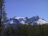
Hoodoo Mountain is a potentially active flat-topped stratovolcano
in the Stikine Country
of northwestern British Columbia
, Canada
, located 74 km (46 mi) northeast of Wrangell, Alaska
on the north side of the lower Iskut River
and 30 km (19 mi) east of its junction with the Stikine River
. It is situated in the Boundary Ranges
of the Coast Mountains
and has been in existence since the Late Pleistocene
stage of the Pleistocene
epoch, which began 130,000 years ago and ended 10,000 years ago. The mountain gets its name from the needle-like lava spine
s or hoodoos
that reach heights of 150 m (492 ft), which give the volcano a strange appearance. This appearance makes Hoodoo Mountain different from other neighbouring mountains in the Boundary Ranges.
The volcano boasts an ice cap
on its summit, and radar imaging of the rock beneath the ice has shown that the mountain's flat-topped summit is not just attributable to the ice cap, but the top of the mountain is flat as well. Beneath the summit ice cap lies an ice-filled volcanic crater
that rises at an elevation of 1850 m (6,070 ft) and a topographic prominence
of 900 m (2,953 ft). Except for minor irregularities caused by erosion, any contour line
drawn is practically a circle.
Hoodoo Mountain consists of a balanced lava dome
6 km (4 mi) in diameter and throughout most of its history, it has been influenced by glacial ice, causing several periods of subglacial eruption
s and interactions between volcanic activity and ice sheets. This volcanic process has created Hoodoo's structure and stratigraphy
similar to subglacial volcano
es.
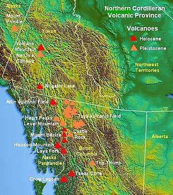 Hoodoo Mountain lies on the southern axis of the Northern Cordilleran Volcanic Province
, a large line of volcanoes extending from the Alaska
-Yukon
border to a point near Prince Rupert, British Columbia
. The region in turn is part of the Pacific Ring of Fire
, a seismically
active region that encircles the Pacific Ocean
and contains some of the world's most active volcanoes. The Northern Cordilleran Volcanic Province is produced by continent
al rifting as the Pacific Plate
slides northward along the Queen Charlotte Fault
, on its way to the Aleutian Trench
, which extends along the southern coastline of Alaska
and the adjacent waters of northeastern Siberia
off the coast of Kamchatka Peninsula
. As the continental crust stretches, hot magma
rises and the near-surface rocks fracture along steeply graduated cracks parallel to the rift known as faults. Like many other rift-related volcanoes, Hoodoo Mountain generates passive and occasionally explosive eruptions. Hoodoo Mountain is one of the three large compositionally diverse volcanoes of the Northern Cordilleran Volcanic Province along with the Mount Edziza volcanic complex
and Level Mountain Range
.
The overall flat-topped topography
of Hoodoo Mountain led Canadian volcanologist Jack Souther
to refer Hoodoo Mountain as a tuya
, which are flat-topped, steep-sided subglacial volcano
es formed when lava erupts through a thick glacier or ice sheet. However, Hoodoo Mountain does not fit the normal tuya model because of its complex layering of rocks, although Hoodoo's unusual structure obviously results from frequent interactions between volcanic activity and Pleistocene ice sheets over the past 100,000 years.
 Hoodoo Mountain contains at least two sets of prominent cliffs, producing a discontinuous, step-like topographic profile. The base of Hoodoo Mountain is largely delimited by a series of cliffs that range from 100 m (328 ft) to 200 m (656 ft) high, while Hoodoo's southeastern flank is relatively gentle. Here, lava flows from the most recent volcanic activity cover earlier topography; the southeastern flank is smooth from around the summit to the Iskut River. The top of the lower cliff ring defines a broad bench with an elevation of about 1000 m (3,281 ft) that terminates against an upper set of cliffs. The seconed set of vertical cliffs is between 50 m (164 ft) and 100 m (328 ft) high and surrounds the summit. A prominent dike
, known as The Monument, rises more than 100 m (328 ft) in elevation on Hoodoo's southwestern flank and is the remnants of a volcanic vent surrounded by thick deposits of lava and breccia formed during subglacial eruptions.
Hoodoo Mountain lies in an area of high elevation ecosystem
s colonizing very erodible substrate. The mountain is generally poorly forested due to its high altitude and remote alpine location. This mountainous terrain has made Hoodoo Mountain a site for alpine tundra
. Even though alpine tundra lacks trees, Hoodoo's lower flanks contain mountain hemlock. Because alpine tundra is located in various widely-separated regions on Earth, there is no animal species common to all areas of alpine tundra.
 The western, eastern and northern flanks of Hoodoo Mountain are covered by two valley glaciers known as the Hoodoo
and Twin
glaciers, while Hoodoo's southern flank, which extends down to the floodplain of the Iskut River, is free from glacial ice. Hoodoo Glacier on the volcano's western flank extends at the head of the Hoodoo River
, while the Twin Glacier on Hoodoo's northern and eastern flanks lies at the headwaters of the Twin River
. In the past, Hoodoo Mountain has been covered by glacial ice more than 2 km (1 mi) thick.
The meltwater
from the Hoodoo Glacier drains into the Hoodoo River while meltwater from the Twin Glacier drains into the Twin River. These two relatively small rivers are a source for the much larger Iskut River, flowing from the southern flank of Hoodoo Mountain respectively. Runoff
from the Hoodoo and Twin glaciers and those on surrounding mountains is a source of fresh water for major salmon habitats and fisheries on the Iskut and Stikine rivers.
. This related Pleistocene age subglacial volcano consists of alkaline basalt
and erupted mainly pyroclastic breccia with minor amounts of massive lava, pillow lava, volcanic sandstone
and hyaloclastite. Cross-cutting veinlets of obsidian
indicate these volcanics were formed by partial melting
in the mantle
beneath Little Bear Mountain. Mantle xenolith
s found at Little Bear Mountain may have originated from mid-crustal
depths.
The relatively small size of Little Bear Mountain and its close connection with Hoodoo Mountain indicates it is a parasitic cone. Such geographical features are formed when the vent of the main volcanic edifice (i.e. Hoodoo Mountain) is blocked by cooled and solidified lava, forcing magma to intrude into the lines of weakness at the side of the main volcanic edifice under pressure.
 Hoodoo Mountain is a well-exposed example of peralkaline, phonolitic ice-contact and subglacial volcanism. Studies have shown that a cycle occurs about every 24,000 years, after which activity shifts from subglacial to post-glacial eruptions and then back to subglacial again. This cyclical activity is unique to Hoodoo Mountain among the Northern Cordilleran volcanoes. Three cycles have been clearly identified, including one subglacial eruption and two post-glacial eruptions. Records show that from 85,000 to 80,000 years ago, activity was more intense than it is today. More than 90% of Hoodoo Mountain, which dates back to at least 100,000 years, formed during its early eruptive history and has grown steadily since then. Regional ice thickness during some of Hoodoo Mountain's subglacial eruptions might have been more than 2 km (1 mi) in thickness.
The main volcanics at Hoodoo Mountain are phonolite
and comendic
trachyte
lavas and hyaloclastite
s, although some pyroclastic rock
s also exist. The trachyte and comendic magmas erupted from Hoodoo Mountain and other Northern Cordilleran volcanoes are thought to have been created by fractionation of primary alkali basaltic magma in crustal reservoirs. The estimated volume of erupted material from Hoodoo Mountain is 17 km³ (4 cu mi), and at least six phases of eruptive activity are recognized at the volcano. The first phase of eruptive activity occurred 85,000 years ago in the Late Pleistocene stage of the Pleistocene epoch, producing lava flows, lava domes, and breccia
deposits. These volcanics were erupted under more than 100 m (328 ft) of glacial ice to produce subglacial eruption
s.
During the second eruptive phase 80,000 years ago, eruptions were no longer subglacial, but the volcano was surrounded by ice at least 800 m (2,625 ft) thick. Lava flows during this eruptive phase melted some of the thick glacial ice and ponded around the perimeters of Hoodoo Mountain, which quickly solidified to form a barrier behind which more lava piled up. Such ice-marginal lava flows are anomalously thick and are normally bounded by steep cliffs with fine-scale cooling joints and lots of volcanic glass
. These ice-marginal lava flows form the massive lava cliffs near the base of Hoodoo Mountain and are among Hoodoo's most prominent features.
The third eruptive phase between 80 and 54 thousand years ago was followed by explosive activity that produced pyroclastic flow
s down the northern and western flanks of the mountain to create welded and unwelded ignimbrite
deposits up to 100 m (328 ft) thick. This explosive activity is one of the few explosive eruptions throughout Hoodoo Mountain's eruptive history, and could have been caused by magma breaching thinner ice.
During the fourth phase of eruptive activity 54,000 years ago, eruptions were again no longer subglacial. Lava flows from this phase of activity overlie pyroclastic deposits from the third phase of activity and ice-dammed lavas from the seconed phase of activity.
Between 54 and 30 thousand years ago, the fifth phase of eruptive activity occurred subglacially and produced two distinct types of lava-breccia associations. The first subglacial eruption between 54 and 40 thousand years ago produced lava dome
s and monomict breccia, while the other subglacial eruption between 40 and 30 thousand years ago took place under thinner glacial ice.
The final phase of eruptive activity was effusive in nature with no explosive activity (VEI
-0). This effusive volcanism produced lava flows with well-preserved lava channel
s on the northwest and southwest flanks of Hoodoo Mountain in the early Holocene
epoch and are largely unglaciated, suggesting the final eruptive phase occurred in an ice-free environment. These lava flows originated from the mountain's flat-topped summit and volcanic vents on its flanks. Geologists do not always agree on the dates of these more recent eruptions, some dating them to nine thousand years ago, others to as recently as seven thousand years ago.
: the others are Mount Garibaldi
, Castle Rock
, Mount Cayley
, The Volcano
, Crow Lagoon
, Silverthrone Caldera
, Mount Meager
, the Mount Edziza volcanic complex
, Wells Gray-Clearwater volcanic field
and Nazko Cone
. Seismic data suggests that these volcanoes still contain living magma chamber
s, indicating possible future eruptive activity. Although the available data does not produce a clear conclusion, these observations are further indications that some of Canada's volcanoes are potentially active, and that their associated hazards may be significant. The seismic activity correlates both with some of Canada's most youthful volcanoes, and with long-lived volcanoes with a history of significant explosive activity, such as Hoodoo Mountain.
 The volcano continues to pose a serious threat to the surrounding area. In 1997, a group of university and industry scientists associated with the Geological Survey of Canada spent six weeks camping at the edge of Hoodoo's summit ice cap to determine the volume of water on the volcano's summit which could be mobilized in the event of an eruption using ice-penetrating radar
. This group included Mark Stasiuk and Catherine Hickson
of the Geological Survey of Canada, Alison Rust, Kelly Russell and Ben Edwards of the University of British Columbia
, Trevor Page of Lancaster University
, Guy Cross and Jeff Schmok of Golder Associates and Jim Nicholls of the University of Calgary
. Hoodoo's summit ice cap remains 150 m (492.1 ft) thick and 3 km (1.9 mi) in diameter and throughout the volcano's history, it has been influenced by glacial ice. Most of the volcano's volcanic activity has produced lava flows from its flat-topped summit, indicating any potential volcanism will occur under the summit ice cap to trigger considerable melting, flood
ing and mudflow
s, which could have a disastrous effect on the adjacent Iskut
and Stikine
rivers. Although very few people live in the region, large mining and mineral exploration camps exist 15 km (9.3 mi) south of Hoodoo Mountain on the Iskut River. Should there be renewed activity in the form of lava flows, damming of the Iskut River would be a significant hazard to these mining and mineral operations. In the 1980s, the Iskut River was studied as a possible site for a hydroelectric plan. However, the plain was left alone partly because of the uncertain volcanic potential in the surrounding environment. High columns of volcanic ash associated with explosive eruptions would have more widespread effects, including disruption of air traffic between Canada, Alaska, and Asia. However, this is a less possibility because most eruptions at Hoodoo Mountain are lava flows.
The Interagency Volcanic Event Notification Plan
, Canada's volcanic emergency notification program, was established to outline the notification procedure to some of the main agencies that would be involved in response to a volcanic eruption in Canada, an eruption close to Canada's borders, or an eruption significant enough to have an effect on Canada and its people. It focuses primarily on aviation safety because air traffic can quickly enter areas of volcanic ash. The program notifies all impacted agencies that have to deal with volcanic events. Aircraft are rerouted away from hazardous ash and people on the ground are notified of potential ash fall.
is. The existing network of seismograph
s has been established to monitor tectonic earthquakes and is too far away to provide a good indication of what is happening beneath the mountain. It may sense an increase in activity if the volcano becomes very restless, but this may only provide a warning for a large eruption. It might detect activity only once the volcano has started erupting.
Stratovolcano
A stratovolcano, also known as a composite volcano, is a tall, conical volcano built up by many layers of hardened lava, tephra, pumice, and volcanic ash. Unlike shield volcanoes, stratovolcanoes are characterized by a steep profile and periodic, explosive eruptions...
in the Stikine Country
Stikine Country
The Stikine Country, also referred to as the Stikine District or simply "the Stikine" , is one of the historical geographic regions of the Canadian province of British Columbia, located inland from the central Alaska Panhandle and comprising the basin of the Stikine River and its tributaries...
of northwestern British Columbia
British Columbia
British Columbia is the westernmost of Canada's provinces and is known for its natural beauty, as reflected in its Latin motto, Splendor sine occasu . Its name was chosen by Queen Victoria in 1858...
, Canada
Canada
Canada is a North American country consisting of ten provinces and three territories. Located in the northern part of the continent, it extends from the Atlantic Ocean in the east to the Pacific Ocean in the west, and northward into the Arctic Ocean...
, located 74 km (46 mi) northeast of Wrangell, Alaska
Wrangell, Alaska
Wrangell is a city and borough in the U.S. state of Alaska. At the 2000 census the population was 2,308.Its Tlingit name is Ḵaachx̱aana.áakʼw . The Tlingit people residing in the Wrangell area, who were there centuries before Europeans, call themselves the Shtaxʼhéen Ḵwáan after the nearby Stikine...
on the north side of the lower Iskut River
Iskut River
The Iskut River is the largest tributary of the Stikine River in northwestern British Columbia, Canada, entering it a few miles above its entry into Alaska....
and 30 km (19 mi) east of its junction with the Stikine River
Stikine River
The Stikine River is a river, historically also the Stickeen River, approximately 610 km long, in northwestern British Columbia in Canada and southeastern Alaska in the United States...
. It is situated in the Boundary Ranges
Boundary Ranges
The Boundary Ranges, also known in the singular and as the Alaska Boundary Range, are the largest and most northerly subrange of the Coast Mountains...
of the Coast Mountains
Coast Mountains
The Coast Mountains are a major mountain range, in the Pacific Coast Ranges, of western North America, extending from southwestern Yukon through the Alaska Panhandle and virtually all of the Coast of British Columbia. They are so-named because of their proximity to the sea coast, and are often...
and has been in existence since the Late Pleistocene
Late Pleistocene
The Late Pleistocene is a stage of the Pleistocene Epoch. The beginning of the stage is defined by the base of the Eemian interglacial phase before the final glacial episode of the Pleistocene 126,000 ± 5,000 years ago. The end of the stage is defined exactly at 10,000 Carbon-14 years BP...
stage of the Pleistocene
Pleistocene
The Pleistocene is the epoch from 2,588,000 to 11,700 years BP that spans the world's recent period of repeated glaciations. The name pleistocene is derived from the Greek and ....
epoch, which began 130,000 years ago and ended 10,000 years ago. The mountain gets its name from the needle-like lava spine
Lava spine
A lava spine is a vertically growing monolith of viscous lava that is slowly forced from a volcanic vent, such as those growing on a lava dome . It may also be considered a kind of dome called a spiny dome . In February of 1983, the dome activity of Mount St...
s or hoodoos
Hoodoo (geology)
A hoodoo is a tall, thin spire of rock that protrudes from the bottom of an arid drainage basin or badland. Hoodoos consist of relatively soft rock topped by harder, less easily eroded stone that protects each column from the elements...
that reach heights of 150 m (492 ft), which give the volcano a strange appearance. This appearance makes Hoodoo Mountain different from other neighbouring mountains in the Boundary Ranges.
The volcano boasts an ice cap
Ice cap
An ice cap is an ice mass that covers less than 50 000 km² of land area . Masses of ice covering more than 50 000 km² are termed an ice sheet....
on its summit, and radar imaging of the rock beneath the ice has shown that the mountain's flat-topped summit is not just attributable to the ice cap, but the top of the mountain is flat as well. Beneath the summit ice cap lies an ice-filled volcanic crater
Volcanic crater
A volcanic crater is a circular depression in the ground caused by volcanic activity. It is typically a basin, circular in form within which occurs a vent from which magma erupts as gases, lava, and ejecta. A crater can be of large dimensions, and sometimes of great depth...
that rises at an elevation of 1850 m (6,070 ft) and a topographic prominence
Topographic prominence
In topography, prominence, also known as autonomous height, relative height, shoulder drop , or prime factor , categorizes the height of the mountain's or hill's summit by the elevation between it and the lowest contour line encircling it and no higher summit...
of 900 m (2,953 ft). Except for minor irregularities caused by erosion, any contour line
Contour line
A contour line of a function of two variables is a curve along which the function has a constant value. In cartography, a contour line joins points of equal elevation above a given level, such as mean sea level...
drawn is practically a circle.
Hoodoo Mountain consists of a balanced lava dome
Lava dome
|250px|thumb|right|Image of the [[rhyolitic]] lava dome of [[Chaitén Volcano]] during its 2008–2009 eruption.In volcanology, a lava dome is a roughly circular mound-shaped protrusion resulting from the slow extrusion of viscous lava from a volcano...
6 km (4 mi) in diameter and throughout most of its history, it has been influenced by glacial ice, causing several periods of subglacial eruption
Subglacial eruption
A subglacial eruption is a volcanic eruption that has occurred under ice, or under a glacier. Subglacial eruptions can cause dangerous floods, lahars and create hyaloclastite and pillow lava. Subglacial eruptions sometimes form a subglacial volcano called a tuya. Tuyas in Iceland are called table...
s and interactions between volcanic activity and ice sheets. This volcanic process has created Hoodoo's structure and stratigraphy
Stratigraphy
Stratigraphy, a branch of geology, studies rock layers and layering . It is primarily used in the study of sedimentary and layered volcanic rocks....
similar to subglacial volcano
Subglacial volcano
A subglacial volcano, also known as a glaciovolcano, is a volcanic form produced by subglacial eruptions or eruptions beneath the surface of a glacier or ice sheet which is then melted into a lake by the rising lava...
es.
Geography and geology
Northern Cordilleran volcanic province
The Northern Cordilleran Volcanic Province , formerly known as the Stikine Volcanic Belt, is a geologic province defined by the occurrence of Miocene to Holocene volcanoes in the Pacific Northwest of North America...
, a large line of volcanoes extending from the Alaska
Alaska
Alaska is the largest state in the United States by area. It is situated in the northwest extremity of the North American continent, with Canada to the east, the Arctic Ocean to the north, and the Pacific Ocean to the west and south, with Russia further west across the Bering Strait...
-Yukon
Yukon
Yukon is the westernmost and smallest of Canada's three federal territories. It was named after the Yukon River. The word Yukon means "Great River" in Gwich’in....
border to a point near Prince Rupert, British Columbia
Prince Rupert, British Columbia
Prince Rupert is a port city in the province of British Columbia, Canada. It is the land, air, and water transportation hub of British Columbia's North Coast, and home to some 12,815 people .-History:...
. The region in turn is part of the Pacific Ring of Fire
Pacific Ring of Fire
The Pacific Ring of Fire is an area where large numbers of earthquakes and volcanic eruptions occur in the basin of the Pacific Ocean. In a horseshoe shape, it is associated with a nearly continuous series of oceanic trenches, volcanic arcs, and volcanic belts and/or plate movements...
, a seismically
Earthquake
An earthquake is the result of a sudden release of energy in the Earth's crust that creates seismic waves. The seismicity, seismism or seismic activity of an area refers to the frequency, type and size of earthquakes experienced over a period of time...
active region that encircles the Pacific Ocean
Pacific Ocean
The Pacific Ocean is the largest of the Earth's oceanic divisions. It extends from the Arctic in the north to the Southern Ocean in the south, bounded by Asia and Australia in the west, and the Americas in the east.At 165.2 million square kilometres in area, this largest division of the World...
and contains some of the world's most active volcanoes. The Northern Cordilleran Volcanic Province is produced by continent
Continent
A continent is one of several very large landmasses on Earth. They are generally identified by convention rather than any strict criteria, with seven regions commonly regarded as continents—they are : Asia, Africa, North America, South America, Antarctica, Europe, and Australia.Plate tectonics is...
al rifting as the Pacific Plate
Pacific Plate
The Pacific Plate is an oceanic tectonic plate that lies beneath the Pacific Ocean. At 103 million square kilometres, it is the largest tectonic plate....
slides northward along the Queen Charlotte Fault
Queen Charlotte Fault
The Queen Charlotte Fault is an active transform fault, located between the North American Plate and the Pacific Plate, Canada's equivalent of the San Andreas Fault. The Queen Charlotte Fault forms a triple junction on its south with the Cascadia subduction zone and the Explorer Ridge...
, on its way to the Aleutian Trench
Aleutian Trench
The Aleutian Trench is a subduction zone and oceanic trench which runs along the southern coastline of Alaska and the adjacent waters of northeastern Siberia off the coast of Kamchatka Peninsula. It is classified as a "marginal trench" in the east as it runs along the margin of the continent, and...
, which extends along the southern coastline of Alaska
Alaska
Alaska is the largest state in the United States by area. It is situated in the northwest extremity of the North American continent, with Canada to the east, the Arctic Ocean to the north, and the Pacific Ocean to the west and south, with Russia further west across the Bering Strait...
and the adjacent waters of northeastern Siberia
Siberia
Siberia is an extensive region constituting almost all of Northern Asia. Comprising the central and eastern portion of the Russian Federation, it was part of the Soviet Union from its beginning, as its predecessor states, the Tsardom of Russia and the Russian Empire, conquered it during the 16th...
off the coast of Kamchatka Peninsula
Kamchatka Peninsula
The Kamchatka Peninsula is a peninsula in the Russian Far East, with an area of . It lies between the Pacific Ocean to the east and the Sea of Okhotsk to the west...
. As the continental crust stretches, hot magma
Magma
Magma is a mixture of molten rock, volatiles and solids that is found beneath the surface of the Earth, and is expected to exist on other terrestrial planets. Besides molten rock, magma may also contain suspended crystals and dissolved gas and sometimes also gas bubbles. Magma often collects in...
rises and the near-surface rocks fracture along steeply graduated cracks parallel to the rift known as faults. Like many other rift-related volcanoes, Hoodoo Mountain generates passive and occasionally explosive eruptions. Hoodoo Mountain is one of the three large compositionally diverse volcanoes of the Northern Cordilleran Volcanic Province along with the Mount Edziza volcanic complex
Mount Edziza volcanic complex
The Mount Edziza volcanic complex is a large and potentially active north-south trending complex volcano in Stikine Country, northwestern British Columbia, Canada, located southeast of the small community of Telegraph Creek...
and Level Mountain Range
Level Mountain Range
The Level Mountain Range, also known as Level Mountain, is a mountain range in Cassiar Country, northwestern British Columbia, Canada, located just northeast of Callison Ranch, southwest of Dease Lake and about north of Mount Edziza. It consists of a massive shield volcano and lies on the Nahlin...
.
The overall flat-topped topography
Topography
Topography is the study of Earth's surface shape and features or those ofplanets, moons, and asteroids...
of Hoodoo Mountain led Canadian volcanologist Jack Souther
Jack Souther
Jack Souther is an Bancroft Award winning American-Canadian volcanologist of the Geological Survey of Canada. He is a leading authority on geothermal resources and volcanism in the Canadian Cordillera. Souther has long been in demand as a professor to lay audiences because of his ability to give...
to refer Hoodoo Mountain as a tuya
Tuya
A tuya is a type of distinctive, flat-topped, steep-sided volcano formed when lava erupts through a thick glacier or ice sheet. They are somewhat rare worldwide, being confined to regions which were covered by glaciers and also had active volcanism during the same time period.-Formation:Tuyas are...
, which are flat-topped, steep-sided subglacial volcano
Subglacial volcano
A subglacial volcano, also known as a glaciovolcano, is a volcanic form produced by subglacial eruptions or eruptions beneath the surface of a glacier or ice sheet which is then melted into a lake by the rising lava...
es formed when lava erupts through a thick glacier or ice sheet. However, Hoodoo Mountain does not fit the normal tuya model because of its complex layering of rocks, although Hoodoo's unusual structure obviously results from frequent interactions between volcanic activity and Pleistocene ice sheets over the past 100,000 years.
Dike (geology)
A dike or dyke in geology is a type of sheet intrusion referring to any geologic body that cuts discordantly across* planar wall rock structures, such as bedding or foliation...
, known as The Monument, rises more than 100 m (328 ft) in elevation on Hoodoo's southwestern flank and is the remnants of a volcanic vent surrounded by thick deposits of lava and breccia formed during subglacial eruptions.
Hoodoo Mountain lies in an area of high elevation ecosystem
Ecosystem
An ecosystem is a biological environment consisting of all the organisms living in a particular area, as well as all the nonliving , physical components of the environment with which the organisms interact, such as air, soil, water and sunlight....
s colonizing very erodible substrate. The mountain is generally poorly forested due to its high altitude and remote alpine location. This mountainous terrain has made Hoodoo Mountain a site for alpine tundra
Alpine tundra
Alpine tundra is a natural region that does not contain trees because it is at high altitude. Alpine tundra is distinguished from arctic tundra, because alpine soils are generally better drained than arctic soils...
. Even though alpine tundra lacks trees, Hoodoo's lower flanks contain mountain hemlock. Because alpine tundra is located in various widely-separated regions on Earth, there is no animal species common to all areas of alpine tundra.
Glaciers
Hoodoo Glacier
Hoodoo Glacier is a glacier in northwestern British Columbia, Canada, located on the western flank of Hoodoo Mountain. It lies at the headwaters of the Hoodoo River.-References:...
and Twin
Twin Glacier
Twin Glacier is a glacier in northwestern British Columbia, Canada, located on the northern and eastern flanks of Hoodoo Mountain. It lies at the headwaters of the Twin River.-References:...
glaciers, while Hoodoo's southern flank, which extends down to the floodplain of the Iskut River, is free from glacial ice. Hoodoo Glacier on the volcano's western flank extends at the head of the Hoodoo River
Hoodoo River
The Hoodoo River is a river in northwestern British Columbia, Canada, located west of Hoodoo Mountain and the Twin River. Its drainage is the larger Iskut River....
, while the Twin Glacier on Hoodoo's northern and eastern flanks lies at the headwaters of the Twin River
Twin River
Twin River is a river in northwestern British Columbia, Canada, located east of Hoodoo Mountain. It flows south into the much larger Iskut River....
. In the past, Hoodoo Mountain has been covered by glacial ice more than 2 km (1 mi) thick.
The meltwater
Meltwater
Meltwater is the water released by the melting of snow or ice, including glacial ice and ice shelfs over oceans. Meltwater is often found in the ablation zone of glaciers, where the rate of snow cover is reducing...
from the Hoodoo Glacier drains into the Hoodoo River while meltwater from the Twin Glacier drains into the Twin River. These two relatively small rivers are a source for the much larger Iskut River, flowing from the southern flank of Hoodoo Mountain respectively. Runoff
Surface runoff
Surface runoff is the water flow that occurs when soil is infiltrated to full capacity and excess water from rain, meltwater, or other sources flows over the land. This is a major component of the water cycle. Runoff that occurs on surfaces before reaching a channel is also called a nonpoint source...
from the Hoodoo and Twin glaciers and those on surrounding mountains is a source of fresh water for major salmon habitats and fisheries on the Iskut and Stikine rivers.
Related features
Lying just on the northern flank of Hoodoo Mountain is a small tuya known as Little Bear MountainLittle Bear Mountain
Little Bear Mountain is a basaltic Pleistocene age tuya in the Boundary Ranges of the Coast Mountains that adjoins Hoodoo Mountain to the north. Little Bear Mountain is part of the Northern Cordilleran Volcanic Province.-See also:* List of volcanoes in Canada...
. This related Pleistocene age subglacial volcano consists of alkaline basalt
Basalt
Basalt is a common extrusive volcanic rock. It is usually grey to black and fine-grained due to rapid cooling of lava at the surface of a planet. It may be porphyritic containing larger crystals in a fine matrix, or vesicular, or frothy scoria. Unweathered basalt is black or grey...
and erupted mainly pyroclastic breccia with minor amounts of massive lava, pillow lava, volcanic sandstone
Sandstone
Sandstone is a sedimentary rock composed mainly of sand-sized minerals or rock grains.Most sandstone is composed of quartz and/or feldspar because these are the most common minerals in the Earth's crust. Like sand, sandstone may be any colour, but the most common colours are tan, brown, yellow,...
and hyaloclastite. Cross-cutting veinlets of obsidian
Obsidian
Obsidian is a naturally occurring volcanic glass formed as an extrusive igneous rock.It is produced when felsic lava extruded from a volcano cools rapidly with minimum crystal growth...
indicate these volcanics were formed by partial melting
Partial melting
Partial melting occurs when only a portion of a solid is melted. For mixed substances, such as a rock containing several different minerals or a mineral that displays solid solution, this melt can be different from the bulk composition of the solid....
in the mantle
Mantle (geology)
The mantle is a part of a terrestrial planet or other rocky body large enough to have differentiation by density. The interior of the Earth, similar to the other terrestrial planets, is chemically divided into layers. The mantle is a highly viscous layer between the crust and the outer core....
beneath Little Bear Mountain. Mantle xenolith
Xenolith
A xenolith is a rock fragment which becomes enveloped in a larger rock during the latter's development and hardening. In geology, the term xenolith is almost exclusively used to describe inclusions in igneous rock during magma emplacement and eruption...
s found at Little Bear Mountain may have originated from mid-crustal
Crust (geology)
In geology, the crust is the outermost solid shell of a rocky planet or natural satellite, which is chemically distinct from the underlying mantle...
depths.
The relatively small size of Little Bear Mountain and its close connection with Hoodoo Mountain indicates it is a parasitic cone. Such geographical features are formed when the vent of the main volcanic edifice (i.e. Hoodoo Mountain) is blocked by cooled and solidified lava, forcing magma to intrude into the lines of weakness at the side of the main volcanic edifice under pressure.
Eruptive history
The main volcanics at Hoodoo Mountain are phonolite
Phonolite
Phonolite is a rare igneous, volcanic rock of intermediate composition, with aphanitic to porphyritic texture....
and comendic
Comendite
Comendite is a hard, peralkaline igneous rock, a type of light blue grey rhyolite. Phenocrysts are sodic sanidine with minor albite and bipyrimidal quartz. Comendite occurs in the mountains Tibrogargan, Coonowrin, Tunbubudla, Coochin, Saddleback, Tibberoowuccum and Ngungun in the Glass House...
trachyte
Trachyte
Trachyte is an igneous volcanic rock with an aphanitic to porphyritic texture. The mineral assemblage consists of essential alkali feldspar; relatively minor plagioclase and quartz or a feldspathoid such as nepheline may also be present....
lavas and hyaloclastite
Hyaloclastite
Hyaloclastite is a hydrated tuff-like breccia rich in black volcanic glass, formed during volcanic eruptions under water, under ice or where subaerial flows reach the sea or other bodies of water. It has the appearance of angular flat fragments sized between a millimeter to few centimeters...
s, although some pyroclastic rock
Pyroclastic rock
Pyroclastic rocks or pyroclastics are clastic rocks composed solely or primarily of volcanic materials. Where the volcanic material has been transported and reworked through mechanical action, such as by wind or water, these rocks are termed volcaniclastic...
s also exist. The trachyte and comendic magmas erupted from Hoodoo Mountain and other Northern Cordilleran volcanoes are thought to have been created by fractionation of primary alkali basaltic magma in crustal reservoirs. The estimated volume of erupted material from Hoodoo Mountain is 17 km³ (4 cu mi), and at least six phases of eruptive activity are recognized at the volcano. The first phase of eruptive activity occurred 85,000 years ago in the Late Pleistocene stage of the Pleistocene epoch, producing lava flows, lava domes, and breccia
Breccia
Breccia is a rock composed of broken fragments of minerals or rock cemented together by a fine-grained matrix, that can be either similar to or different from the composition of the fragments....
deposits. These volcanics were erupted under more than 100 m (328 ft) of glacial ice to produce subglacial eruption
Subglacial eruption
A subglacial eruption is a volcanic eruption that has occurred under ice, or under a glacier. Subglacial eruptions can cause dangerous floods, lahars and create hyaloclastite and pillow lava. Subglacial eruptions sometimes form a subglacial volcano called a tuya. Tuyas in Iceland are called table...
s.
During the second eruptive phase 80,000 years ago, eruptions were no longer subglacial, but the volcano was surrounded by ice at least 800 m (2,625 ft) thick. Lava flows during this eruptive phase melted some of the thick glacial ice and ponded around the perimeters of Hoodoo Mountain, which quickly solidified to form a barrier behind which more lava piled up. Such ice-marginal lava flows are anomalously thick and are normally bounded by steep cliffs with fine-scale cooling joints and lots of volcanic glass
Volcanic glass
Volcanic glass is the amorphous product of rapidly cooling magma. Like all types of glass, it is a state of matter intermediate between the close-packed, highly ordered array of a crystal and the highly disordered array of gas...
. These ice-marginal lava flows form the massive lava cliffs near the base of Hoodoo Mountain and are among Hoodoo's most prominent features.
The third eruptive phase between 80 and 54 thousand years ago was followed by explosive activity that produced pyroclastic flow
Pyroclastic flow
A pyroclastic flow is a fast-moving current of superheated gas and rock , which reaches speeds moving away from a volcano of up to 700 km/h . The flows normally hug the ground and travel downhill, or spread laterally under gravity...
s down the northern and western flanks of the mountain to create welded and unwelded ignimbrite
Ignimbrite
An ignimbrite is the deposit of a pyroclastic density current, or pyroclastic flow, a hot suspension of particles and gases that flows rapidly from a volcano, driven by a greater density than the surrounding atmosphere....
deposits up to 100 m (328 ft) thick. This explosive activity is one of the few explosive eruptions throughout Hoodoo Mountain's eruptive history, and could have been caused by magma breaching thinner ice.
During the fourth phase of eruptive activity 54,000 years ago, eruptions were again no longer subglacial. Lava flows from this phase of activity overlie pyroclastic deposits from the third phase of activity and ice-dammed lavas from the seconed phase of activity.
Between 54 and 30 thousand years ago, the fifth phase of eruptive activity occurred subglacially and produced two distinct types of lava-breccia associations. The first subglacial eruption between 54 and 40 thousand years ago produced lava dome
Lava dome
|250px|thumb|right|Image of the [[rhyolitic]] lava dome of [[Chaitén Volcano]] during its 2008–2009 eruption.In volcanology, a lava dome is a roughly circular mound-shaped protrusion resulting from the slow extrusion of viscous lava from a volcano...
s and monomict breccia, while the other subglacial eruption between 40 and 30 thousand years ago took place under thinner glacial ice.
The final phase of eruptive activity was effusive in nature with no explosive activity (VEI
Volcanic Explosivity Index
The Volcanic Explosivity Index was devised by Chris Newhall of the U.S. Geological Survey and Stephen Self at the University of Hawaii in 1982 to provide a relative measure of the explosiveness of volcanic eruptions....
-0). This effusive volcanism produced lava flows with well-preserved lava channel
Lava channel
A lava channel is a stream of fluid lava contained within marginal zones of static lava or levees. The initial channel may not contain levees per se, until the parental flow solidifies over what develops into the channel and creates simple levees. This initial levee allows for the building of a...
s on the northwest and southwest flanks of Hoodoo Mountain in the early Holocene
Holocene
The Holocene is a geological epoch which began at the end of the Pleistocene and continues to the present. The Holocene is part of the Quaternary period. Its name comes from the Greek words and , meaning "entirely recent"...
epoch and are largely unglaciated, suggesting the final eruptive phase occurred in an ice-free environment. These lava flows originated from the mountain's flat-topped summit and volcanic vents on its flanks. Geologists do not always agree on the dates of these more recent eruptions, some dating them to nine thousand years ago, others to as recently as seven thousand years ago.
Recent activity
Hoodoo Mountain is one of the eleven Canadian volcanoes associated with recent seismic activitySeismology
Seismology is the scientific study of earthquakes and the propagation of elastic waves through the Earth or through other planet-like bodies. The field also includes studies of earthquake effects, such as tsunamis as well as diverse seismic sources such as volcanic, tectonic, oceanic,...
: the others are Mount Garibaldi
Mount Garibaldi
Mount Garibaldi is a potentially active stratovolcano in the Sea to Sky Country of British Columbia, north of Vancouver, Canada. Located in the southernmost Coast Mountains, it is one of the most recognized peaks in the South Coast region, as well as British Columbia's best known volcano...
, Castle Rock
Castle Rock
-Islands:*Castle Rock , an island off the coast of the U.S. state of Alaska*Castle Rock, Hong Kong , an island of Hong Kong, part of the Po Toi Islands*Castle Rock , an island in the U.S...
, Mount Cayley
Mount Cayley
Mount Cayley is a potentially active stratovolcano in Squamish-Lillooet Regional District of southwestern British Columbia, Canada. Located north of Squamish and west of Whistler in the Pacific Ranges of the Coast Mountains, it rises above the Squamish River to the west and above the Cheakamus...
, The Volcano
The Volcano (British Columbia)
The Volcano, also known as Lava Fork volcano, is a small cinder cone in the Boundary Ranges of the Coast Mountains in northwestern British Columbia, Canada. It is located approximately northwest of the small community of Stewart near the head of Lava Fork...
, Crow Lagoon
Crow Lagoon
Crow Lagoon is a little-known volcanic center located north of Prince Rupert, British Columbia, Canada. There are beds of thick, basaltic tephra that are of Holocene age....
, Silverthrone Caldera
Silverthrone Caldera
The Silverthrone Caldera is a potentially active caldera complex in southwestern British Columbia, Canada, located over northwest of the city of Vancouver and about west of Mount Waddington in the Pacific Ranges of the Coast Mountains. The caldera is one of the largest of the few calderas in...
, Mount Meager
Mount Meager
Mount Meager, originally known as Meager Mountain, is a complex volcano in the Sea-to-Sky Corridor of southwestern British Columbia, Canada. It is located north of Vancouver at the northern end of the Pemberton Valley. Part of the Cascade Volcanic Arc of western North America, its summit is above...
, the Mount Edziza volcanic complex
Mount Edziza volcanic complex
The Mount Edziza volcanic complex is a large and potentially active north-south trending complex volcano in Stikine Country, northwestern British Columbia, Canada, located southeast of the small community of Telegraph Creek...
, Wells Gray-Clearwater volcanic field
Wells Gray-Clearwater volcanic field
The Wells Gray-Clearwater volcanic field, also called the Clearwater Cone Group, is a potentially active monogenetic volcanic field in east-central British Columbia, Canada, located approximately north of Kamloops. It is situated in the Cariboo Mountains of the Columbia Mountains and on the...
and Nazko Cone
Nazko Cone
Nazko Cone is a small potentially active basaltic cinder cone in central British Columbia, Canada, located 75 km west of Quesnel and 150 kilometers southwest of Prince George. It is considered the easternmost volcano in the Anahim Volcanic Belt. The small tree-covered cone rises 120 m above...
. Seismic data suggests that these volcanoes still contain living magma chamber
Magma chamber
A magma chamber is a large underground pool of molten rock found beneath the surface of the Earth. The molten rock in such a chamber is under great pressure, and given enough time, that pressure can gradually fracture the rock around it creating outlets for the magma...
s, indicating possible future eruptive activity. Although the available data does not produce a clear conclusion, these observations are further indications that some of Canada's volcanoes are potentially active, and that their associated hazards may be significant. The seismic activity correlates both with some of Canada's most youthful volcanoes, and with long-lived volcanoes with a history of significant explosive activity, such as Hoodoo Mountain.
Current threats and preparedness
Radioglaciology
Radioglaciology is the study of glaciers and ice sheets using radar. It employs a geophysical method similar to ground-penetrating radar that operates at frequencies in the MF, HF and VHF portions of the radio spectrum...
. This group included Mark Stasiuk and Catherine Hickson
Catherine Hickson
Catherine Hickson is a Canadian volcanologist formerly part of the Geological Survey of Canada. Hickson has mapped and studied young volcanoes in Canada assessing their past and future eruptions. In 2003, Hickson was one of the three scientists to report on a hypothetical eruption at the Canadian...
of the Geological Survey of Canada, Alison Rust, Kelly Russell and Ben Edwards of the University of British Columbia
University of British Columbia
The University of British Columbia is a public research university. UBC’s two main campuses are situated in Vancouver and in Kelowna in the Okanagan Valley...
, Trevor Page of Lancaster University
Lancaster University
Lancaster University, officially The University of Lancaster, is a leading research-intensive British university in Lancaster, Lancashire, England. The university was established by Royal Charter in 1964 and initially based in St Leonard's Gate until moving to a purpose-built 300 acre campus at...
, Guy Cross and Jeff Schmok of Golder Associates and Jim Nicholls of the University of Calgary
University of Calgary
The University of Calgary is a public research university located in Calgary, Alberta, Canada. Founded in 1966 the U of C is composed of 14 faculties and more than 85 research institutes and centres.More than 25,000 undergraduate and 5,500 graduate students are currently...
. Hoodoo's summit ice cap remains 150 m (492.1 ft) thick and 3 km (1.9 mi) in diameter and throughout the volcano's history, it has been influenced by glacial ice. Most of the volcano's volcanic activity has produced lava flows from its flat-topped summit, indicating any potential volcanism will occur under the summit ice cap to trigger considerable melting, flood
Flood
A flood is an overflow of an expanse of water that submerges land. The EU Floods directive defines a flood as a temporary covering by water of land not normally covered by water...
ing and mudflow
Mudflow
A mudslide is the most rapid and fluid type of downhill mass wasting. It is a rapid movement of a large mass of mud formed from loose soil and water. Similar terms are mudflow, mud stream, debris flow A mudslide is the most rapid (up to 80 km/h, or 50 mph) and fluid type of downhill mass...
s, which could have a disastrous effect on the adjacent Iskut
Iskut River
The Iskut River is the largest tributary of the Stikine River in northwestern British Columbia, Canada, entering it a few miles above its entry into Alaska....
and Stikine
Stikine River
The Stikine River is a river, historically also the Stickeen River, approximately 610 km long, in northwestern British Columbia in Canada and southeastern Alaska in the United States...
rivers. Although very few people live in the region, large mining and mineral exploration camps exist 15 km (9.3 mi) south of Hoodoo Mountain on the Iskut River. Should there be renewed activity in the form of lava flows, damming of the Iskut River would be a significant hazard to these mining and mineral operations. In the 1980s, the Iskut River was studied as a possible site for a hydroelectric plan. However, the plain was left alone partly because of the uncertain volcanic potential in the surrounding environment. High columns of volcanic ash associated with explosive eruptions would have more widespread effects, including disruption of air traffic between Canada, Alaska, and Asia. However, this is a less possibility because most eruptions at Hoodoo Mountain are lava flows.
The Interagency Volcanic Event Notification Plan
Interagency Volcanic Event Notification Plan
The Interagency Volcanic Event Notification Plan is a program in Canada established to outline the notification procedure of some of the main agencies that would be involved in response to a volcanic eruption in Canada, an eruption close to Canada's borders, or significant enough that a volcanic...
, Canada's volcanic emergency notification program, was established to outline the notification procedure to some of the main agencies that would be involved in response to a volcanic eruption in Canada, an eruption close to Canada's borders, or an eruption significant enough to have an effect on Canada and its people. It focuses primarily on aviation safety because air traffic can quickly enter areas of volcanic ash. The program notifies all impacted agencies that have to deal with volcanic events. Aircraft are rerouted away from hazardous ash and people on the ground are notified of potential ash fall.
Monitoring
Currently Hoodoo Mountain is not monitored closely enough by the Geological Survey of Canada to ascertain how active the volcano's magma chamberMagma chamber
A magma chamber is a large underground pool of molten rock found beneath the surface of the Earth. The molten rock in such a chamber is under great pressure, and given enough time, that pressure can gradually fracture the rock around it creating outlets for the magma...
is. The existing network of seismograph
Seismometer
Seismometers are instruments that measure motions of the ground, including those of seismic waves generated by earthquakes, volcanic eruptions, and other seismic sources...
s has been established to monitor tectonic earthquakes and is too far away to provide a good indication of what is happening beneath the mountain. It may sense an increase in activity if the volcano becomes very restless, but this may only provide a warning for a large eruption. It might detect activity only once the volcano has started erupting.
See also
- List of volcanoes in Canada
- List of Northern Cordilleran volcanoes
- List of stratovolcanoes
- Volcanism of Canada
- Volcanism of Western CanadaVolcanism of Western CanadaVolcanism of Western Canada produces lava flows, lava plateaus, lava domes, cinder cones, stratovolcanoes, shield volcanoes, submarine volcanoes, calderas, diatremes and maars, along with examples of more less common volcanic forms such as tuyas and subglacial mounds.-Volcanic belts:*Anahim...
External links
- Volcanoes of Canada Stikine Volcanic Belt (Hoodoo Mountain area)