

Trans-Hudson orogeny
Encyclopedia
Mountain
Image:Himalaya_annotated.jpg|thumb|right|The Himalayan mountain range with Mount Everestrect 58 14 160 49 Chomo Lonzorect 200 28 335 52 Makalurect 378 24 566 45 Mount Everestrect 188 581 920 656 Tibetan Plateaurect 250 406 340 427 Rong River...
building (orogeny
Orogeny
Orogeny refers to forces and events leading to a severe structural deformation of the Earth's crust due to the engagement of tectonic plates. Response to such engagement results in the formation of long tracts of highly deformed rock called orogens or orogenic belts...
) event that formed the Precambrian
Precambrian
The Precambrian is the name which describes the large span of time in Earth's history before the current Phanerozoic Eon, and is a Supereon divided into several eons of the geologic time scale...
Canadian Shield
Canadian Shield
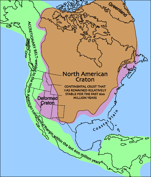
The Canadian Shield, also called the Laurentian Plateau, or Bouclier Canadien , is a vast geological shield covered by a thin layer of soil that forms the nucleus of the North American or Laurentia craton. It is an area mostly composed of igneous rock which relates to its long volcanic history...
, the North American craton (also called Laurentia
Laurentia
Laurentia is a large area of continental craton, which forms the ancient geological core of the North American continent...
), and the forging of the initial North American
North American
North American generally refers to an entity, people, group, or attribute of North America, especially of the United States and Canada together.-Culture:*North American English, a collective term used to describe American English and Canadian English...
continent
Continent
A continent is one of several very large landmasses on Earth. They are generally identified by convention rather than any strict criteria, with seven regions commonly regarded as continents—they are : Asia, Africa, North America, South America, Antarctica, Europe, and Australia.Plate tectonics is...
. It is the largest Paleoproterozoic orogenic belt in the world. It consists of a network of belts that were formed by Proterozoic crust
Crust (geology)
In geology, the crust is the outermost solid shell of a rocky planet or natural satellite, which is chemically distinct from the underlying mantle...
al accretion
Accretion (geology)
Accretion is a process by which material is added to a tectonic plate or a landmass. This material may be sediment, volcanic arcs, seamounts or other igneous features.-Description:...
and the collision of pre-existing Archean
Archean
The Archean , also spelled Archeozoic or Archæozoic) is a geologic eon before the Paleoproterozoic Era of the Proterozoic Eon, before 2.5 Ga ago. Instead of being based on stratigraphy, this date is defined chronometrically...
continents. The event occurred 2.0-1.8 billion years ago.
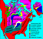
The Trans-Hudson orogen sutured together the Hearne-Rae
Rae craton
right|thumb|250px|North America cratons and basement rock.The Rae craton is an Archean craton located in northern Canada north of the Superior craton.-Ungava Peninsula:...
, Superior
Superior craton
The Superior craton forms the core of the Canadian Shield at the heart of the North American continent. It extends from Quebec in the east to eastern Manitoba in the west...
, and Wyoming
Wyoming craton
The Wyoming craton is a craton located in the west-central United States and western Canada – more specifically, in Montana, Wyoming, southern Alberta, southern Saskatchewan, and parts of northern Utah...
cratons to form the cratonic core of North America in a network of Paleoproterozoic orogenic belts. These orogenic belts include the margins of at least nine independent microcontinents that were themselves sections of at least three former major supercontinents, including Laurasia
Laurasia
In paleogeography, Laurasia was the northernmost of two supercontinents that formed part of the Pangaea supercontinent from approximately...
, Pangaea
Pangaea
Pangaea, Pangæa, or Pangea is hypothesized as a supercontinent that existed during the Paleozoic and Mesozoic eras about 250 million years ago, before the component continents were separated into their current configuration....
and Kenorland
Kenorland
Kenorland was one of the earliest supercontinents on Earth. It is believed to have formed during the Neoarchaean Era ~2.7 billion years ago by the accretion of Neoarchaean cratons and the formation of new continental crust...
(ca. 2.7 Ga), and contain parts of some of the oldest cratonic continental crust
Continental crust
The continental crust is the layer of igneous, sedimentary, and metamorphic rocks which form the continents and the areas of shallow seabed close to their shores, known as continental shelves. This layer is sometimes called sial due to more felsic, or granitic, bulk composition, which lies in...
on Earth
Earth
Earth is the third planet from the Sun, and the densest and fifth-largest of the eight planets in the Solar System. It is also the largest of the Solar System's four terrestrial planets...
. These old cratonic blocks, along with accreted island arc
Volcanic arc
A volcanic arc is a chain of volcanoes positioned in an arc shape as seen from above. Offshore volcanoes form islands, resulting in a volcanic island arc. Generally they result from the subduction of an oceanic tectonic plate under another tectonic plate, and often parallel an oceanic trench...
terrane
Terrane
A terrane in geology is short-hand term for a tectonostratigraphic terrane, which is a fragment of crustal material formed on, or broken off from, one tectonic plate and accreted or "sutured" to crust lying on another plate...
s and intraoceanic
Ocean
An ocean is a major body of saline water, and a principal component of the hydrosphere. Approximately 71% of the Earth's surface is covered by ocean, a continuous body of water that is customarily divided into several principal oceans and smaller seas.More than half of this area is over 3,000...
deposits from earlier Proterozoic and Mesozoic
Mesozoic
The Mesozoic era is an interval of geological time from about 250 million years ago to about 65 million years ago. It is often referred to as the age of reptiles because reptiles, namely dinosaurs, were the dominant terrestrial and marine vertebrates of the time...
oceans and seaways, were sutured together in the Trans-Hudson Orogen (THO) and resulted in extensive folding and thrust fault
Thrust fault
A thrust fault is a type of fault, or break in the Earth's crust across which there has been relative movement, in which rocks of lower stratigraphic position are pushed up and over higher strata. They are often recognized because they place older rocks above younger...
ing along with metamorphism and hundreds of huge granitic intrusion
Intrusion
An intrusion is liquid rock that forms under Earth's surface. Magma from under the surface is slowly pushed up from deep within the earth into any cracks or spaces it can find, sometimes pushing existing country rock out of the way, a process that can take millions of years. As the rock slowly...
s.
The THO is a right-angled suture zone that extends eastward from Saskatchewan
Saskatchewan
Saskatchewan is a prairie province in Canada, which has an area of . Saskatchewan is bordered on the west by Alberta, on the north by the Northwest Territories, on the east by Manitoba, and on the south by the U.S. states of Montana and North Dakota....
through collisional belts in the Churchill province
Churchill craton
The Churchill craton is the northwest section of the Canadian Shield and stretches from southern Saskatchewan and Alberta to northern Nunavut. It has a very complex geological history punctuated by at least seven distinct regional tectonometamorphic intervals, including many discrete accretionary...
, through northern Quebec
Quebec
Quebec or is a province in east-central Canada. It is the only Canadian province with a predominantly French-speaking population and the only one whose sole official language is French at the provincial level....
, parts of Labrador
Labrador
Labrador is the distinct, northerly region of the Canadian province of Newfoundland and Labrador. It comprises the mainland portion of the province, separated from the island of Newfoundland by the Strait of Belle Isle...
and Baffin Island
Baffin Island
Baffin Island in the Canadian territory of Nunavut is the largest island in the Canadian Arctic Archipelago, the largest island in Canada and the fifth largest island in the world. Its area is and its population is about 11,000...
, and all the way to Greenland
Greenland
Greenland is an autonomous country within the Kingdom of Denmark, located between the Arctic and Atlantic Oceans, east of the Canadian Arctic Archipelago. Though physiographically a part of the continent of North America, Greenland has been politically and culturally associated with Europe for...
as the Rinkian belt and Nagssugtodidian Orogen. Westward it goes across Hudson Bay
Hudson Bay
Hudson Bay , sometimes called Hudson's Bay, is a large body of saltwater in northeastern Canada. It drains a very large area, about , that includes parts of Ontario, Quebec, Saskatchewan, Alberta, most of Manitoba, southeastern Nunavut, as well as parts of North Dakota, South Dakota, Minnesota,...
through Saskatchewan and then extends 90 degrees south through eastern Montana
Montana
Montana is a state in the Western United States. The western third of Montana contains numerous mountain ranges. Smaller, "island ranges" are found in the central third of the state, for a total of 77 named ranges of the Rocky Mountains. This geographical fact is reflected in the state's name,...
and the western Dakota
The Dakotas
The Dakotas is a collective term that refers to the U.S. states of North Dakota and South Dakota together. The term has been used historically to describe the Dakota Territory, and is continued to be used to describe the collective heritage, culture, geography, fauna, sociology, the economy, and...
s, downward through eastern Wyoming
Wyoming
Wyoming is a state in the mountain region of the Western United States. The western two thirds of the state is covered mostly with the mountain ranges and rangelands in the foothills of the Eastern Rocky Mountains, while the eastern third of the state is high elevation prairie known as the High...
and western Nebraska
Nebraska
Nebraska is a state on the Great Plains of the Midwestern United States. The state's capital is Lincoln and its largest city is Omaha, on the Missouri River....
, and is then cut off by the Cheyenne belt
Cheyenne belt
The Cheyenne Belt is the tectonic suture zone between the Archean-age Wyoming craton to the north and the Paleoproterozoic-age Yavapai province to the south. In runs through the southeastern quadrant of the state of Wyoming, USA. It was formed during the Paleoproterozoic Medicine Bow orogeny...
- the northern edge of the Yavapai province (see Trans-Hudson Orogen map and the THOT Transect map. To the south, the orogen contributed to the subsurface Phanerozoic
Phanerozoic
The Phanerozoic Eon is the current eon in the geologic timescale, and the one during which abundant animal life has existed. It covers roughly 542 million years and goes back to the time when diverse hard-shelled animals first appeared...
strata in Montana and the Dakotas that created the Great Plains
Great Plains
The Great Plains are a broad expanse of flat land, much of it covered in prairie, steppe and grassland, which lies west of the Mississippi River and east of the Rocky Mountains in the United States and Canada. This area covers parts of the U.S...
.
Overview
The Trans-Hudson orogeny was the culminating event of the Paleoproterozoic Laurentian assembly, which occurred after the Wopmay orogeny (West of Hudson BayHudson Bay
Hudson Bay , sometimes called Hudson's Bay, is a large body of saltwater in northeastern Canada. It drains a very large area, about , that includes parts of Ontario, Quebec, Saskatchewan, Alberta, most of Manitoba, southeastern Nunavut, as well as parts of North Dakota, South Dakota, Minnesota,...
, ca. 2.1-1.9 Ga.). The Trans-Hudson orogeny resulted from the collision of the Superior craton of eastern Canada
Canada
Canada is a North American country consisting of ten provinces and three territories. Located in the northern part of the continent, it extends from the Atlantic Ocean in the east to the Pacific Ocean in the west, and northward into the Arctic Ocean...
with the Hearne craton in northern Saskatchewan
Saskatchewan
Saskatchewan is a prairie province in Canada, which has an area of . Saskatchewan is bordered on the west by Alberta, on the north by the Northwest Territories, on the east by Manitoba, and on the south by the U.S. states of Montana and North Dakota....
and the Wyoming craton of the western United States
United States
The United States of America is a federal constitutional republic comprising fifty states and a federal district...
, with the Archaen microcontinent Sask craton trapped in the THO western interior. The northern edge of the THO is marked by an exposed continental collision zone on Baffin Island
Baffin Island
Baffin Island in the Canadian territory of Nunavut is the largest island in the Canadian Arctic Archipelago, the largest island in Canada and the fifth largest island in the world. Its area is and its population is about 11,000...
(Canada
Canada
Canada is a North American country consisting of ten provinces and three territories. Located in the northern part of the continent, it extends from the Atlantic Ocean in the east to the Pacific Ocean in the west, and northward into the Arctic Ocean...
) that occurred between ca. 1.85-1.835 Ga. On Baffin Island, ca. 1.845 Ga. crust
Crust (geology)
In geology, the crust is the outermost solid shell of a rocky planet or natural satellite, which is chemically distinct from the underlying mantle...
al thickening occurred that was associated with accretion of an intra-oceanic arc terrane and subsequent regional metamorphic
Metamorphism
Metamorphism is the solid-state recrystallization of pre-existing rocks due to changes in physical and chemical conditions, primarily heat, pressure, and the introduction of chemically active fluids. Mineralogical, chemical and crystallographic changes can occur during this process...
activity characterized by the growth of retrograde, upper amphibolite
Amphibolite
Amphibolite is the name given to a rock consisting mainly of hornblende amphibole, the use of the term being restricted, however, to metamorphic rocks. The modern terminology for a holocrystalline plutonic igneous rocks composed primarily of hornblende amphibole is a hornblendite, which are...
-facies
Facies
In geology, facies are a body of rock with specified characteristics. Ideally, a facies is a distinctive rock unit that forms under certain conditions of sedimentation, reflecting a particular process or environment....
assemblages that define a clockwise, decompressive P–T path
Phase diagram
A phase diagram in physical chemistry, engineering, mineralogy, and materials science is a type of chart used to show conditions at which thermodynamically distinct phases can occur at equilibrium...
(pressure
Pressure
Pressure is the force per unit area applied in a direction perpendicular to the surface of an object. Gauge pressure is the pressure relative to the local atmospheric or ambient pressure.- Definition :...
-temperature
Temperature
Temperature is a physical property of matter that quantitatively expresses the common notions of hot and cold. Objects of low temperature are cold, while various degrees of higher temperatures are referred to as warm or hot...
) path. Final mineral
Mineral
A mineral is a naturally occurring solid chemical substance formed through biogeochemical processes, having characteristic chemical composition, highly ordered atomic structure, and specific physical properties. By comparison, a rock is an aggregate of minerals and/or mineraloids and does not...
growth on Baffin Island occurred between 1.82-1.81 Ga. and occurred as a progressive change from plate-margin to intraplate processes within an evolving convergent orogeny. Collectively, these collisions resulted in a mountain range that rivaled the grandeur of the Himalayas
Himalayas
The Himalaya Range or Himalaya Mountains Sanskrit: Devanagari: हिमालय, literally "abode of snow"), usually called the Himalayas or Himalaya for short, is a mountain range in Asia, separating the Indian subcontinent from the Tibetan Plateau...
. Similar to the Himalayas, the Trans-Hudson orogeny was also the result of continent-continent collision along a suture zone. Only the roots of this mountain chain remain, but these can be seen in northeastern Saskatchewan and in the Black Hills of South Dakota. The Trans-Hudson orogeny and the consequent upheaval of the continental crust in the middle Proterozoic eon caused the area around the Great Lakes
Great Lakes
The Great Lakes are a collection of freshwater lakes located in northeastern North America, on the Canada – United States border. Consisting of Lakes Superior, Michigan, Huron, Erie, and Ontario, they form the largest group of freshwater lakes on Earth by total surface, coming in second by volume...
to become a flattened plain, which in turn led to the creation of the intercontinental basin and the interior and central plains of the United States
United States
The United States of America is a federal constitutional republic comprising fifty states and a federal district...
(the Great Plains
Great Plains
The Great Plains are a broad expanse of flat land, much of it covered in prairie, steppe and grassland, which lies west of the Mississippi River and east of the Rocky Mountains in the United States and Canada. This area covers parts of the U.S...
are the westernmost portion of North America's Interior Plains
Interior Plains
The Interior Plains is a vast physiographic region that spreads across the Laurentian craton of central North America.-Geography:The Interior Plains are an extensive physiographic division encompassing 8 distinct physiographic provinces, the Interior Low Plateaus, Great Plains, Central Lowland,...
, which extend east to the Appalachian Plateau
Appalachian Plateau
The Appalachian Plateau is the western part of the Appalachian mountains, stretching from New York and Alabama. The plateau is a second level United States physiographic region....
).
The Black Hills
Black Hills
The Black Hills are a small, isolated mountain range rising from the Great Plains of North America in western South Dakota and extending into Wyoming, USA. Set off from the main body of the Rocky Mountains, the region is something of a geological anomaly—accurately described as an "island of...
of South Dakota
South Dakota
South Dakota is a state located in the Midwestern region of the United States. It is named after the Lakota and Dakota Sioux American Indian tribes. Once a part of Dakota Territory, South Dakota became a state on November 2, 1889. The state has an area of and an estimated population of just over...
is one of the few remaining exposed portions of the Trans-Hudson orogenic belt. It is a huge, elliptically domed area in northwestern South Dakota and northeastern Wyoming about 125 miles long and 65 miles wide where the THO uplift caused erosion to remove the overlying cover of the Proterozoic marine sedimentary rocks and expose the granite and metamorphic rocks that formed the core of the dome. The peaks of the Black Hills are 3,000 to 4,000 feet above the surrounding plains, while Harney Peak - the highest point in South Dakota - has an altitude of 7,242 feet above sea level. These central spires and peaks all are carved from granite and other igneous and metamorphic rocks that form the core of the uplift. The nature and timing of this portion of the THO event in southern Laurentia is poorly understood compared to the exposed northern segments in Canada. The Black Hills offer the only surface exposure of the deformed and metamorphosed belt of Paleoproterozoic continental margin rocks in the collisional zone between the Archean
Archean
The Archean , also spelled Archeozoic or Archæozoic) is a geologic eon before the Paleoproterozoic Era of the Proterozoic Eon, before 2.5 Ga ago. Instead of being based on stratigraphy, this date is defined chronometrically...
Wyoming and Superior provinces. Based on geophysical evidence, this zone has been broadly interpreted to be the southern extension of the THO that was later truncated by the ~1.680 Ga. Central Plains orogen.
Sequence of events
Marine evidence indicates that the area initially opened to form an ocean called the Manikewan Ocean. Faulting, sedimentary and igneous rockIgneous rock
Igneous rock is one of the three main rock types, the others being sedimentary and metamorphic rock. Igneous rock is formed through the cooling and solidification of magma or lava...
s all indicate that divergence formed a rift valley
Rift valley
A rift valley is a linear-shaped lowland between highlands or mountain ranges created by the action of a geologic rift or fault. This action is manifest as crustal extension, a spreading apart of the surface which is subsequently further deepened by the forces of erosion...
that continued to spread until it resulted in a passive margin in which there was no tectonic activity. Shallow marine deposits formed on the continental shelves, and oceanic crust
Oceanic crust
Oceanic crust is the part of Earth's lithosphere that surfaces in the ocean basins. Oceanic crust is primarily composed of mafic rocks, or sima, which is rich in iron and magnesium...
formed on the margins of the continental cratons as the divergence continued. Eventually the divergence stopped, then reversed direction, and collision occurred between continental land masses. During the Wopmay orogeny, subduction occurred as oceanic crust of the Slave craton
Slave craton
The Slave craton is a Canadian geological formation located in the Northwest Territories and Nunavut. This craton is approximately in size and forms part of the Canadian Shield. It is dominated by ca. 2.73-2.63 Ga greenstones and turbidite sequences and ca. 2.72-2.58 Ga plutonic rock, with large...
was subducted beneath an eastward moving continental plate. Likewise, during the Trans-Hudson orogeny, rifting at first separated the Superior craton from the rest of the continent. Then the Superior craton reversed its direction and the ocean basin began to close. A subduction zone formed as the oceanic crust of the Superior craton was subducted beneath the Hearne and Wyoming craton with the Sask craton in the middle. Volcanic arcs developed as the cratons collided, eventually resulting in the THO mountain building (orogeny).
During the opening and then closure of the Manikewan Ocean, the following sequence of events occurred:
- Deposition of passive margin sequences, beginning at ca. 2.16 Ga.
- Ocean closure beginning at ca. 1.92 Ga in the western THO, leading to the formation of the La Ronge/Lynn Lake, the Flin FlonFlin FlonFlin Flon is a Canadian mining city located on the border of Manitoba and Saskatchewan, with the majority of the city located within Manitoba.- Founding :...
Domain/Glennie island arcs, and the Pelican Thrust located between the two volcanic arc complexes and the Archaen Sask craton. - Beginning at about 1.88 Ga, accretion of the La Ronge/Lynn Lake arcs to the Hearne craton margin and related deposition of an extensive molasseMolasseThe term "molasse" refers to the sandstones, shales and conglomerates formed as terrestrial or shallow marine deposits in front of rising mountain chains. The molasse is deposited in a foreland basin, especially on top of flysch, for example that left from the rising Alps, or erosion in the Himalaya...
/foredeep sequence. This event was contemporaneous with intraoceanic accretion leading to the formation of the Flin Flon/Glennie accretionary complex. - Continental arc magmatismMagmatismThe formation of igneous rocks from magma is known as Magmatism.Magmatism is a process responsible for mountain formation. The process of magmatism produces an additional mass and volume to the Earth’s surface. For example the formation of volcanoes or island arcs at convergent plate boundaries...
along the SE margin of the Churchill plate between 1.86 Ga and 1.85 Ga. - Cessation of continental arc magmatism at about 1.850 Ga, perhaps related to collision of the Flin Flon/Glennie complex (western THO) and Narsajuaq arc (Baffin segment), with the Churchill plate.
- Opening of the Kissinew back-arc basinBack-arc basinBack-arc basins are geologic features, submarine basins associated with island arcs and subduction zones.They are found at some convergent plate boundaries, presently concentrated in the Western Pacific ocean. Most of them result from tensional forces caused by oceanic trench rollback and the...
during the interval 1.85-1.84 Ga, with the Flin Flon complex now forming part of the active arc and Granville Lake Structural Zone forming part of the remnant arc. - Collision between the Sask Craton and Churchill Plate, beginning at ca. 1.84 Ga, leading to the inversionInversion (geology)In structural geology inversion or basin inversion relates to the relative uplift of a sedimentary basin or similar structure as a result of crustal shortening. This normally excludes uplift developed in the footwalls of later extensional faults, or uplift caused by mantle plumes...
of the Kisseynew basin and deposition of molasse deposits. - Terminal collision involving the Superior craton, beginning at ca. 1.83 Ga and ongoing until approximately 1.77 Ga. (Corrigan, 2004).).
- The final stages of continental collision where marked by 1.84-1.82 Ga. magma generation within the Kisseynew domain related to interaction between the Sask craton and the Flin FlonFlin Flon greenstone beltThe Flin Flon greenstone belt, also referred to as the Flin Flon-Snow Lake greenstone belt, is a Precambrian greenstone belt located in the central area of Manitoba and east-central Saskatchewan, Canada . It lies in the central portion of the Trans-Hudson orogeny and was formed by arc volcanism...
–Glennie complex, and a 1.82-1.79 Ga. collision of the Rae and Superior cratons. A decrease in subduction angle likely resulted from northward-directed subduction of more buoyant crust, with associated changes in thermal conditions leading to melting over a wide area. Ultimately subduction ceased, and the slab foundered into the mantle, potentially resulting in the generation of alkalic and potassic magmas within the Rae and Hearne cratons.
Geographic areas
The Trans-Hudson Orogen is the only fully preserved Early Proterozoic orogenic belt in North America. It is a network of belts formed by Proterozoic crustal accretion and the collision of pre-existing Archean continents: the Hearne-Rae provinces to the northwest, the Superior Province to the southeast, and the Wyoming province to the southwest. In the northern SaskatchewanSaskatchewan
Saskatchewan is a prairie province in Canada, which has an area of . Saskatchewan is bordered on the west by Alberta, on the north by the Northwest Territories, on the east by Manitoba, and on the south by the U.S. states of Montana and North Dakota....
and Manitoba
Manitoba
Manitoba is a Canadian prairie province with an area of . The province has over 110,000 lakes and has a largely continental climate because of its flat topography. Agriculture, mostly concentrated in the fertile southern and western parts of the province, is vital to the province's economy; other...
provinces, the 500 km wide orogen includes four major lithotectonic zones:
- a northwest hinterland zone (divided into smaller domains);
- an Andean-type magmatic arc batholith;
- an internal zone of juvenile Proterozoic crust;
- a southeast foreland zone (with prominent, pervasive east-dipping seismicSeismologySeismology is the scientific study of earthquakes and the propagation of elastic waves through the Earth or through other planet-like bodies. The field also includes studies of earthquake effects, such as tsunamis as well as diverse seismic sources such as volcanic, tectonic, oceanic,...
reflectors throughout the crust (not west-dipping as expected) where the orogen bounds the Superior Province).
Northwestern hinterland zone
The Northwestern hinterland zone is a complex tectonically deformed region that includes the Peter Lake, Wollaston, and Seal River domains, and other parts of the Cree Lake Zone, now included in Hearne Province.Reindeer zone
The Reindeer zone to the north is a 500 km wide collage of Paleoproterozoic (1.92-1.83 Ga) arc volcanic rocks, plutons, volcanogenic sediments, and younger molasseMolasse
The term "molasse" refers to the sandstones, shales and conglomerates formed as terrestrial or shallow marine deposits in front of rising mountain chains. The molasse is deposited in a foreland basin, especially on top of flysch, for example that left from the rising Alps, or erosion in the Himalaya...
, divisible into several lithostructural domains. Most of these rocks evolved in an oceanic to transitional, subduction-related arc setting, with increasing influence of Archean crustal components to the northwest. The zone overlies Archean basement exposed in structural window that are now recognized as the Sask craton.
Wathaman-Chipewyan batholith
The Wathaman-Chipewyan batholithBatholith
A batholith is a large emplacement of igneous intrusive rock that forms from cooled magma deep in the Earth's crust...
is an Andean-type continental-margin, magmatic arc emplaced 1.86-1.85 Ga.
Glennie domain
The Glennie domain is in the western segment of the orogen in the internal zone in Saskatchewan, and consists mostly of 2.4–2.5 Ga felsicFelsic
The word "felsic" is a term used in geology to refer to silicate minerals, magma, and rocks which are enriched in the lighter elements such as silicon, oxygen, aluminium, sodium, and potassium....
plutonic rocks enveloped by the Nistowiak Thrust. The Nistowiak Thrust is a folded, 1–2 km thick, upper amphibolite
Amphibolite
Amphibolite is the name given to a rock consisting mainly of hornblende amphibole, the use of the term being restricted, however, to metamorphic rocks. The modern terminology for a holocrystalline plutonic igneous rocks composed primarily of hornblende amphibole is a hornblendite, which are...
facies
Facies
In geology, facies are a body of rock with specified characteristics. Ideally, a facies is a distinctive rock unit that forms under certain conditions of sedimentation, reflecting a particular process or environment....
mylonite
Mylonite
Mylonite is a fine-grained, compact rock produced by dynamic recrystallization of the constituent minerals resulting in a reduction of the grain size of the rock. It is classified as a metamorphic rock...
zone formed during emplacement of the Flin Flon–Glennie Complex across the ancient Saskatchewan continental area. It correlates to the Pelican Thrust, which envelops Archaean basement windows in the Hanson Lake Block 100 km to the east. There is an internal high strain zone within the overlying nappe
Nappe
In geology, a nappe is a large sheetlike body of rock that has been moved more than or 5 km from its original position. Nappes form during continental plate collisions, when folds are sheared so much that they fold back over on themselves and break apart. The resulting structure is a...
pile called the Guncoat Thrust that is composed primarily of mylonitized
Mylonite
Mylonite is a fine-grained, compact rock produced by dynamic recrystallization of the constituent minerals resulting in a reduction of the grain size of the rock. It is classified as a metamorphic rock...
porphyroclastic pelitic
Pelite
Pelite is old and currently not widely used field terminology for a clayey fine-grained clastic sediment or sedimentary rock, i.e. mud or mudstone. It is equivalent to the Latin-derived term lutite. More commonly, metamorphic geologists currently use pelite for a metamorphosed fine-grained...
and psammitic migmatite
Migmatite
Migmatite is a rock at the frontier between igneous and metamorphic rocks. They can also be known as diatexite.Migmatites form under extreme temperature conditions during prograde metamorphism, where partial melting occurs in pre-existing rocks. Migmatites are not crystallized from a totally...
s. U-Pb geochronological results suggest 1.889–1.837 Ga calc-alkaline
Calc-alkaline
The calc-alkaline magma series is one of two main magma series in igneous rocks, the other magma series being the tholeiitic. A magma series is a series of compositions that describes the evolution of a mafic magma, which is high in magnesium and iron and produces basalt or gabbro, as it...
plutonism, thrust stacking, peak metamorphism and associated 1.837-1.809 Ga anatexis
Anatexis
Anatexis in geology, refers to the differential, or partial, melting of rocks, especially in the forming of metamorphic rocks such as migmatites.-Optimum Temperature Conditions for Crustal Melting:...
, isotopic closure of titanite
Titanite
Titanite, or sphene , is a calcium titanium nesosilicate mineral, CaTiSiO5. Trace impurities of iron and aluminium are typically present...
at 1.790–1.772 Ga, and intrusion of late granitic rocks at 1.770–1.762 Ga. This is in agreement with ages from the Hanson Lake Block, and La Ronge, Kisseynew, and Flin‐Flon domains in Saskatchewan and Manitoba, and from the Ungava
Ungava
Ungava may refer to:* Ungava Peninsula, in northern Quebec* Ungava , Quebec's largest and most northern provincial riding* Ungava Bay, on the northern coast of Quebec, on Hudson Strait...
‐Baffin portion of Trans-Hudson Orogen, suggesting broadly synchronous
Synchronization
Synchronization is timekeeping which requires the coordination of events to operate a system in unison. The familiar conductor of an orchestra serves to keep the orchestra in time....
thermo
Thermo
Thermo, descended from , meaning heat, is a prefix referring to heat or temperature, e.g.,* thermodynamics, the physics of energy, heat, work, and entropy, which is also discussed in the article heat...
tectonic processes along a strike length of 2,000 km. This suggests that the Saskatchewan continental section rifted from the Superior and/or Hearne Provinces ca. 2.1 Ga and that the Maniwekan Ocean developed between the Rae-Hearne and Superior cratons as their plate motions opened and closed. The consequent crustal formations around parts of the arc-granitoid
Granitoid
A granitoid or granitic rock is a variety of coarse grained plutonic rock similar to granite which mineralogically are composed predominately of feldspar and quartz. Examples of granitoid rocks include granite, quartz monzonite, quartz diorite, syenite, granodiorite and trondhjemite. Many are...
Glennie domain surface features are penetrated by Archean basement "windows". These Archaean basement "windows" is what identifies the previously unknown Archean microcontinent, now called the Sask craton.
Kisseynew back-arc basin
The Kisseynew back-arc basinBack-arc basin
Back-arc basins are geologic features, submarine basins associated with island arcs and subduction zones.They are found at some convergent plate boundaries, presently concentrated in the Western Pacific ocean. Most of them result from tensional forces caused by oceanic trench rollback and the...
(Kisseynew domain) is a metasedimentary gneiss
Gneiss
Gneiss is a common and widely distributed type of rock formed by high-grade regional metamorphic processes from pre-existing formations that were originally either igneous or sedimentary rocks.-Etymology:...
belt that is one of the most extensive tectonic segments of the Paleoproterozoic Trans-Hudson orogen in north-central Canada. It comprises turbidites (horizontally spread out sediments deposited from a swiftly moving downward-flowing current, such as from an existing continental slope) and continental sandstone
Sandstone
Sandstone is a sedimentary rock composed mainly of sand-sized minerals or rock grains.Most sandstone is composed of quartz and/or feldspar because these are the most common minerals in the Earth's crust. Like sand, sandstone may be any colour, but the most common colours are tan, brown, yellow,...
s, both of which are interlayered with volcanic rocks and intruded pluton
Pluton
A pluton in geology is a body of intrusive igneous rock that crystallized from magma slowly cooling below the surface of the Earth. Plutons include batholiths, dikes, sills, laccoliths, lopoliths, and other igneous bodies...
s. The dating of the encompanying detrital
Detrital
Detritus is a geological term used to describe particles of rock derived from pre-existing rock through processes of weathering and erosion. Detrital particles can consist of lithic fragments , or of monomineralic fragments...
zircons and the dates of the intruded crosscutting plutons constrain the dates of the turbidite sedimentation to 1.855-1.841 Ga. These turbidites are interpreted to have been deposited in a back-arc basin behind a retreating subduction boundary. This postdates the early deformation and metamorphism
Metamorphism
Metamorphism is the solid-state recrystallization of pre-existing rocks due to changes in physical and chemical conditions, primarily heat, pressure, and the introduction of chemically active fluids. Mineralogical, chemical and crystallographic changes can occur during this process...
of the Trans-Hudson orogeny associated with arc-arc and arc-continent collisions. The turbidites are deposited in a back-arc basin behind a retreating subduction boundary. The Kisseynew domain and its southern flank are marked by 1.84-1.83 Ga magmatic rocks related to subduction of back-arc basin oceanic crust. Collapse of the Kisseynew "basin" by ductile fold-and-thrust deformation began during 1.84-1.83 Ga magmatism and continued through peak metamorphism at ca. 1.820-1.805 Ga. The result was that the high-grade core of the Kisseynew domain was structurally emplaced over adjacent low-grade terranes. The extensive high-temperature/low-pressure metamorphism explains the thickening and thermal relaxation of the basin-fill rocks that are marked by a 1.84-1.83 Ga elevated geotherm magmatism.
Flin Flon greenstone belt
The Flin Flon greenstone beltFlin Flon greenstone belt
The Flin Flon greenstone belt, also referred to as the Flin Flon-Snow Lake greenstone belt, is a Precambrian greenstone belt located in the central area of Manitoba and east-central Saskatchewan, Canada . It lies in the central portion of the Trans-Hudson orogeny and was formed by arc volcanism...
is part of the internal zone of the Trans-Hudson Orogen and consists of Paleoproterozoic volcanic, plutonic and minor sedimentary rocks. The exposed portion of the belt is 250 km long by 75 km wide. Although it has an apparent easterly trend, this is an artifact of the belt's tectonic contact with gneissic metasedimentary, metavolcanic and plutonic rocks to the north (Kisseynew Domain) and the east-trending trace of Phanerozoic platformal cover rocks to the south. In reality the Flin Flon greenstone belt
Greenstone belt
Greenstone belts are zones of variably metamorphosed mafic to ultramafic volcanic sequences with associated sedimentary rocks that occur within Archaean and Proterozoic cratons between granite and gneiss bodies....
extends hundreds of kilometres to the south-southwest beneath a thin, geophysically transparent Phanerozoic
Phanerozoic
The Phanerozoic Eon is the current eon in the geologic timescale, and the one during which abundant animal life has existed. It covers roughly 542 million years and goes back to the time when diverse hard-shelled animals first appeared...
cover. To the north the Flin Flon greenstone belt is tectonically overthrust by younger metasedimentary rocks of the Kisseynew domain and by nappe
Nappe
In geology, a nappe is a large sheetlike body of rock that has been moved more than or 5 km from its original position. Nappes form during continental plate collisions, when folds are sheared so much that they fold back over on themselves and break apart. The resulting structure is a...
s of metavolcanic rocks of the same age. In fact, the entire Flin Flon-Snow Lake domain is an imbricated thrust wedge carried on a lower detachment zone overridden by high grade Kisseynew gneisses.
The NATMAP Shield Margin Project and LITHOPROBE Trans-Hudson Orogen Transect have shown that the Flin Flon greenstone belt (and contained VMS deposits) is only one of three components in a northeast-dipping stack that was juxtaposed during the 1.84-1.80 Ga collisional deformations.
1) at the lowest structural level (exposed in the Pelican window): metaplutonic rocks and paragneisses (3.20-2.40 Ga) of the "Sask craton".
2) at intermediate structural levels: Flin Flon greenstone belt (now defined to include the Attitti block and Paleoproterozoic rocks in the Hanson Lake block) and Glennie Domain (together comprising the "Flin Flon-Glennie complex."
3) at the highest structural levels: marine turbidites (Burntwood Group; 1.85-1.84 Ga) and partly coeval distal facies of alluvial-fluvial sandstones (Missi Group) in the Kisseynew Domain.
The Flin Flon greenstone belt is usually described by two stratigraphic groups: the 1.92-1.87 Ga. Amisk Group volcanic-plutonic rocks, and the Missi Group continental sedimentary rocks. The Flin Flon greenstone belt is a collage of distinct tectonostratigraphic
Tectonostratigraphy
In geology, tectonostratigraphy refers either to rock sequences in which large-scale layering is caused by the stacking of thrust sheets or nappes in areas of thrust tectonics or the effects of tectonics on lithostratigraphy.-Tectonically formed stratigraphy:...
assemblages composed of structurally juxtaposed volcanic and sedimentary rock that were emplaced in a variety of tectonic environments. The major 1.92-1.88 Ga components include significant juvenile arc and juvenile ocean-floor rocks, and minor ocean plateau/ocean island basalt. The juvenile arc assemblage comprises tholeiitic
Tholeiite
The tholeiitic magma series is one of two main magma series in igneous rocks, the other magma series being the calc–alkaline. A magma series is a series of compositions that describes the evolution of a mafic magma, which is high in magnesium and iron and produces basalt or gabbro, as it...
, calc-alkaline
Calc-alkaline
The calc-alkaline magma series is one of two main magma series in igneous rocks, the other magma series being the tholeiitic. A magma series is a series of compositions that describes the evolution of a mafic magma, which is high in magnesium and iron and produces basalt or gabbro, as it...
and lesser shoshonitic
Shoshonite
Shoshonite is a basaltic rock, properly a potassic trachyandesite, composed of olivine, augite and plagioclase phenocrysts in a groundmass with calcic plagioclase and sanidine and some dark-colored volcanic glass. Shoshonite gives its name to the shoshonite series and grades into absarokite with...
and boninitic
Boninite
Boninite is a mafic extrusive rock high in both magnesium and silica, formed in fore-arc environments, typically during the early stages of subduction. The rock is named for its occurrence in the Izu-Bonin arc south of Japan...
rocks similar in major and trace element geochemistry to modern intraoceanic arcs. Ocean-floor basalt sequences are exclusively tholeiitic, and are geochemically similar to modern N- and E-type MORBs erupted in back-arc basins. Evolved arc assemblages and Archean crustal slices are present within the Flin Flon greenstone belt as minor components. Collectively, these tectonostratigraphic assemblages were juxtaposed in an accretionary complex at Ca. 1.88-1.87 Ga. as a result of arc-arc collisions. The collage was a basement to a 1.87-1.83 Ga post-accretion arc magmatism that was expressed as voluminous calc-alkaline plutons and rarely preserved calc-alkaline to alkaline volcanic rocks. Unroofing of this accretionary collage, and the deposition of continental alluvial-fluvial sedimentary rocks (Missi Group) and marine turbidites (Burntwood Group) occurred Ca. 1.85-1.84 Ga, coeval with the waning stages of post-accretion arc magmatism. The sedimentary suites were imbricated with volcanic assemblages in the eastern Flin Flon greenstone belt during 1.85-1.82 Ga juxtaposition of the supracrustal rocks along pre-peak metamorphic structures. Post ca. 1.83 Ga structures formed the present southwest-verging fold style at the northeastern end of the Flin Flon greenstone belt. Emplacement of voluminous granitoid plutons and regional deformation related to the occurred during the Ca. 1.8 Ga Hudsonian Orogeny.
Flin Flon domain
The Flin Flon domain is in the center of the Trans-Hudson Suture Zone and extends over the border of the Manitoba-Saskatchewan segment east and west. It is west of the Superior craton, south of the Kisseynew Domain, and east of the Glennie Domain.Sask craton
The Sask craton is exposed in two structural windows in the western Flin Flon and Glennie domains to a depth of at least 25 km over an area of at least 100,000 km2. The presence of the Sask craton may have arrested the complete collision of the Superior and Hearne cratons and allowed the preservation of a significant amount of juvenile magmatic and sedimentary terranes in allochthons within the internideInternide
In geology, internides are the internal part of an orogenic belt, farthest away from the craton, which is commonly the site of a eugeosyncline during its early phases and is later subjected to plastic folding and plutonism. Also known as primary arc....
s (Reindeer Zone). The sole of these juvenile terranes is the Pelican Thrust, which is seismically highly recognizable and is considered to be a well-defined orogen-scale discontinuity that facilitated underthrusting of the Archean Sask craton below Paleoproterozoic juvenile rocks from before 1.825 Ga until after 1.805 Ga. This led to thickening of the sedimentary rocks in the overlying Kisseynew Domain and the development of localized high temperature–low pressure peak-metamorphic conditions coeval with melting and advection of heat within this part of the orogen. The Sask craton was initially identified by seismic reflection along the Glennie and western Flin Flon domains and is now known to extend at depth northward and eastward well into Manitoba. Based on MT measurements, the Sask craton is resistive relative to the Paleoproterozoic volcano-sedimentary belts. Lower parts of the crust in the western Glennie Domain may be portions of the Sask craton that are significantly more complicated and comprise interleaved Archean and Paleoproterozoic rocks. The Sask craton includes rocks as old as 3.10 Ga, but it is dominated by a ca. 2.45 Ga magmatic event, and overprinted by metamorphism and deformation during the THO. The range in ages observed, together with Pb isotopic compositions, suggest that the Sask craton is not a fragment of the Superior or Hearne cratons. The Sask craton is associated with a crustal root that trends in a north-northeast direction of about 200 km. In addition, a lithosphere
Lithosphere
The lithosphere is the rigid outermost shell of a rocky planet. On Earth, it comprises the crust and the portion of the upper mantle that behaves elastically on time scales of thousands of years or greater.- Earth's lithosphere :...
region may be spatially associated with the Sask craton lithosphere below the Fort à la Corne kimberlite
Kimberlite
Kimberlite is a type of potassic volcanic rock best known for sometimes containing diamonds. It is named after the town of Kimberley in South Africa, where the discovery of an diamond in 1871 spawned a diamond rush, eventually creating the Big Hole....
. However, the mantle lithosphere preserved below the Sask craton may have been replaced by Superior craton mantle lithosphere during orogenesis.
Superior Boundary zone
The Superior Boundary zone is a narrow, southeastern, ensialicSial
In geology, the sial is the upper layer of the Earth's crust made of rocks rich in silicates and aluminium minerals. It is sometimes equated with the continental crust because it is absent in the wide oceanic basins, but "sial" is a geochemical term rather than a plate tectonic term.Geologists...
foreland zone bordering Superior craton, comprising the Thompson Belt, Split Lake Block, and Fox River Belt.
Economic geology
The Flin Flon greenstone beltFlin Flon greenstone belt
The Flin Flon greenstone belt, also referred to as the Flin Flon-Snow Lake greenstone belt, is a Precambrian greenstone belt located in the central area of Manitoba and east-central Saskatchewan, Canada . It lies in the central portion of the Trans-Hudson orogeny and was formed by arc volcanism...
is one of the largest Proterozoic volcanic-hosted massive sulfide
Volcanogenic massive sulfide ore deposit
Volcanogenic massive sulfide ore deposits are a type of metal sulfide ore deposit, mainly Cu-Zn-Pb which are associated with and created by volcanic-associated hydrothermal events in submarine environments....
(VMS) districts in the world, containing 27 Cu-Zn- (Au) deposits from which more than 183 million tonnes of ore have been mined. Most of mined VMS deposits in the Flin Flon belt are associated with juvenile arc volcanic rocks providing a powerful focus for future explorations. Gold mineralization has been less studied, but at Reed Lake has been shown to be associated with late brittle-ductile shear zones that follow peak tectonic and metamorphic activity within the Trans-Hudson Orogen. At Snow Lake, preliminary investigations suggest a long history of gold mineralization with at least some gold introduced prior to metamorphism.
See also
- Canadian ShieldCanadian ShieldThe Canadian Shield, also called the Laurentian Plateau, or Bouclier Canadien , is a vast geological shield covered by a thin layer of soil that forms the nucleus of the North American or Laurentia craton. It is an area mostly composed of igneous rock which relates to its long volcanic history...
- North American craton
- Wyoming cratonWyoming cratonThe Wyoming craton is a craton located in the west-central United States and western Canada – more specifically, in Montana, Wyoming, southern Alberta, southern Saskatchewan, and parts of northern Utah...
- Superior cratonSuperior cratonThe Superior craton forms the core of the Canadian Shield at the heart of the North American continent. It extends from Quebec in the east to eastern Manitoba in the west...
- Hearne craton
- Rae cratonRae cratonright|thumb|250px|North America cratons and basement rock.The Rae craton is an Archean craton located in northern Canada north of the Superior craton.-Ungava Peninsula:...