
Boundary Ranges
Encyclopedia
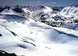
The Boundary Ranges, also known in the singular and as the Alaska Boundary Range, are the largest and most northerly subrange of the Coast Mountains
. They begin at the Nass River
, near the southern end of the Alaska Panhandle
in the Canadian province of British Columbia
and run to the Kelsall River
, near the Chilkoot Pass
, beyond which is the Alsek Ranges
of the Saint Elias Mountains
, and northwards into the Yukon Territory flanking the west side of the Yukon River
drainage as far as Champagne Pass
, north of which being the Yukon Ranges
. To their east are the Skeena Mountains
and Stikine Plateau
of the Interior Mountains
complex that lies northwest of the Interior Plateau
; the immediately adjoining subregion of the Stikine Plateau is the Tahltan Highland
. To their northeast is the Tagish Highland
, which is a subregion of the Yukon Plateau
. Both highlands are considered in some descriptions as included in the Coast Mountains. The Alexander Archipelago
lies offshore and is entirely within Alaska
.
The Boundary Ranges include several large icefields, including the Juneau Icefield
, between the Alaska
city of the same name and Atlin Lake
in B.C.
; and the Stikine Icecap
, which lies between the lower Stikine River
and the Whiting River
. Some of the highest mountains in the Boundary Ranges are: Mount Ratz
, 3090 m (10138 ft), Chutine Peak
, 2910 m (9547 ft), and Devils Thumb
, 2766 m (9077 ft), all in the Stikine Icecap
region; and Devils Paw
, 2593 m (8507 ft), in the Juneau Icefield
. (There are other peaks in the Stikine Icecap
higher than 2600 m (8500 ft) but they have relatively low topographic prominence
.)
Despite the height of Mount Ratz
and its neighbours, most of the Boundary Ranges are considerably lower than the Pacific Ranges
of the southern Coast Mountains
. The larger icefields of the Boundary Ranges are at a much lower elevation than their southern counterparts in the Pacific Ranges
because of the difference in latitude.
Physiographically, they are a section of the larger Pacific Border province, which in turn are part of the larger Pacific Mountain System physiographic division.
The granitic
intrusion
s that form the Boundary Ranges are remnants of a Late Cretaceous
volcanic arc
system called the Coast Range Arc
.
Coast Mountains
The Coast Mountains are a major mountain range, in the Pacific Coast Ranges, of western North America, extending from southwestern Yukon through the Alaska Panhandle and virtually all of the Coast of British Columbia. They are so-named because of their proximity to the sea coast, and are often...
. They begin at the Nass River
Nass River
The Nass River is a river in northern British Columbia, Canada. It flows from the Coast Mountains southwest to Nass Bay, a sidewater of Portland Inlet, which connects to the North Pacific Ocean via the Dixon Entrance...
, near the southern end of the Alaska Panhandle
Alaska Panhandle
Southeast Alaska, sometimes referred to as the Alaska Panhandle, is the southeastern portion of the U.S. state of Alaska, which lies west of the northern half of the Canadian province of British Columbia. The majority of Southeast Alaska's area is part of the Tongass National Forest, the United...
in the Canadian province of British Columbia
British Columbia
British Columbia is the westernmost of Canada's provinces and is known for its natural beauty, as reflected in its Latin motto, Splendor sine occasu . Its name was chosen by Queen Victoria in 1858...
and run to the Kelsall River
Kelsall River
The Kelsall River is a river in the U.S. State of Alaska, the Canadian province of British Columbia, and Yukon Territory. It is a tributary of the Chilkat River, flowing into it in the Haines Borough of Alaska.-See also:*List of rivers of Alaska...
, near the Chilkoot Pass
Chilkoot Pass
Chilkoot Pass is a high mountain pass through the Boundary Ranges of the Coast Mountains in the U.S. state of Alaska and British Columbia, Canada. It is the highest point along the Chilkoot Trail that leads from Dyea, Alaska to Bennett Lake, British Columbia...
, beyond which is the Alsek Ranges
Alsek Ranges
The Alsek Ranges are the southeasternmost subdivision of the Saint Elias Mountains of the Pacific Cordillera. They span the region between the Alsek River, Glacier Bay and the Kelsall River...
of the Saint Elias Mountains
Saint Elias Mountains
The Saint Elias Mountains are a subgroup of the Pacific Coast Ranges, located in southeastern Alaska in the United States, southwestern Yukon and the very far northwestern part of British Columbia in Canada. The range spans Wrangell-St. Elias National Park and Preserve in the USA and Kluane...
, and northwards into the Yukon Territory flanking the west side of the Yukon River
Yukon River
The Yukon River is a major watercourse of northwestern North America. The source of the river is located in British Columbia, Canada. The next portion lies in, and gives its name to Yukon Territory. The lower half of the river lies in the U.S. state of Alaska. The river is long and empties into...
drainage as far as Champagne Pass
Champagne, Yukon
Champagne Landing is a small Indian settlement on the Alaska Highway in Canada's Yukon. The few residents are citizens of the Champagne and Aishihik First Nations. The resident population was 24 in the Canada 2006 Census.Champagne is on the Dezadeash River, one of the tributaries of the Alsek...
, north of which being the Yukon Ranges
Yukon Ranges
The Yukon Ranges are a mountain range comprising the mountains in the southeastern part of the U.S. state of Alaska and most of the Yukon, Canada...
. To their east are the Skeena Mountains
Skeena Mountains
The Skeena Mountains, also known as the Skeenas, are a subrange of the Interior Mountains of northern British Columbia, Canada, essentially flanking the upper basin of the Skeena River. They lie just inland from the southern end of the Boundary Ranges of the Coast Mountains, and also of the...
and Stikine Plateau
Stikine Plateau
The Stikine Plateau is a plateau in northern British Columbia, Canada. It lies between the Boundary Ranges of the Coast Mountains on the west and southwest and the Cassiar Mountains along its northeast, and between the Skeena Mountains on its south and southeast and the Jennings and Nakina Rivers...
of the Interior Mountains
Interior Mountains
The Interior Mountains, also called the Northern Interior Mountains and Interior Ranges, are the semi-official names for a huge area that comprises much of the northern two thirds of the Canadian province of British Columbia and a large area of southern Yukon...
complex that lies northwest of the Interior Plateau
Interior Plateau
The Interior Plateau comprises a large region of central British Columbia, and lies between the Cariboo and Monashee Mountains on the east, and the Hazelton Mountains, Coast Mountains and Cascade Range on the west. The continuation of the plateau into the United States is known there as the...
; the immediately adjoining subregion of the Stikine Plateau is the Tahltan Highland
Tahltan Highland
The Tahltan Highland is an upland area of plateau and relatively lower mountain ranges in British Columbia, Canada, lying east of the Boundary Ranges and south of the Inklin River...
. To their northeast is the Tagish Highland
Tagish Highland
The Tagish Highland is an upland area on the inland side of the northernmost Boundary Ranges of the Coast Mountains, spanning far northwestern British Columbia from Atlin Lake to the area of the pass at Champagne, Yukon between the Alsek and Yukon Rivers...
, which is a subregion of the Yukon Plateau
Yukon Plateau
The Yukon Plateau is a plateau comprising much of the central and southern Yukon Territory and the far northern part of British Columbia, Canada between Tagish Lake and the Cassiar Mountains and north of the Nakina River....
. Both highlands are considered in some descriptions as included in the Coast Mountains. The Alexander Archipelago
Alexander Archipelago
The Alexander Archipelago is a long archipelago, or group of islands, of North America off the southeastern coast of Alaska. It contains about 1,100 islands, which are the tops of the submerged coastal mountains that rise steeply from the Pacific Ocean. Deep channels and fjords separate the...
lies offshore and is entirely within Alaska
Alaska
Alaska is the largest state in the United States by area. It is situated in the northwest extremity of the North American continent, with Canada to the east, the Arctic Ocean to the north, and the Pacific Ocean to the west and south, with Russia further west across the Bering Strait...
.
The Boundary Ranges include several large icefields, including the Juneau Icefield
Juneau Icefield
The Juneau Icefield is an ice field located just north of Juneau, Alaska and continues north through the border with British Columbia and is the fifth-largest ice field in the Western Hemisphere, extending through an area of in the Coast Range ranging north to south and east to west. The...
, between the Alaska
Alaska
Alaska is the largest state in the United States by area. It is situated in the northwest extremity of the North American continent, with Canada to the east, the Arctic Ocean to the north, and the Pacific Ocean to the west and south, with Russia further west across the Bering Strait...
city of the same name and Atlin Lake
Atlin Lake
Atlin Lake is a lake in northwestern British Columbia and is that province's largest natural lake. The northern tip of the lake is in the Yukon, as is Little Atlin Lake. However, most of the lake lies within the Atlin District of British Columbia...
in B.C.
British Columbia
British Columbia is the westernmost of Canada's provinces and is known for its natural beauty, as reflected in its Latin motto, Splendor sine occasu . Its name was chosen by Queen Victoria in 1858...
; and the Stikine Icecap
Stikine Icecap
The Stikine Icecap is a large icefield straddled on the Alaska–British Columbia boundary in the Alaska Panhandle region. It lies in the Boundary Ranges of the Coast Mountains...
, which lies between the lower Stikine River
Stikine River
The Stikine River is a river, historically also the Stickeen River, approximately 610 km long, in northwestern British Columbia in Canada and southeastern Alaska in the United States...
and the Whiting River
Whiting River
The Whiting River is a river in Alaska and British Columbia, entering the waters of Stephens Passage at the Borough of Juneau in the Alaska Panhandle between the mouths of the Taku and Stikine Rivers. The main tributary of the Whiting is the South Whiting. The river's basin is at the northern end...
. Some of the highest mountains in the Boundary Ranges are: Mount Ratz
Mount Ratz
Mount Ratz is a mountain located just west of the Stikine River, about east of the British Columbia-Alaska border. It is the highest peak in the Stikine Icecap and of the Boundary Ranges which in turn form part of the Coast Mountains. It is an extremely high-prominence summit, with a difference...
, 3090 m (10138 ft), Chutine Peak
Chutine Peak
Chutine Peak is one of the highest mountains in the Boundary Ranges, a group of subranges of the northern Coast Mountains of British Columbia and Alaska. Chutine Peak lies just east of the Stikine Icecap, and to the north and west of the Stikine River, and south of the basin of the Whiting River....
, 2910 m (9547 ft), and Devils Thumb
Devils Thumb
Devils Thumb, or Daalkunaxhkhu shaa in Tlingit, is a mountain in the Stikine Icecap region of the Alaska-British Columbia border, near Petersburg. It is named for its projected thumb-like appearance. Its name in the Tlingit language has the meaning "the Mountain That Never Flooded" and is said to...
, 2766 m (9077 ft), all in the Stikine Icecap
Stikine Icecap
The Stikine Icecap is a large icefield straddled on the Alaska–British Columbia boundary in the Alaska Panhandle region. It lies in the Boundary Ranges of the Coast Mountains...
region; and Devils Paw
Devils Paw
Devils Paw is the high point of the Juneau Icefield, on the Alaska-British Columbia border. It is part of the Boundary Ranges of the Coast Mountains. It is also notable for its steep rise above the low local terrain...
, 2593 m (8507 ft), in the Juneau Icefield
Juneau Icefield
The Juneau Icefield is an ice field located just north of Juneau, Alaska and continues north through the border with British Columbia and is the fifth-largest ice field in the Western Hemisphere, extending through an area of in the Coast Range ranging north to south and east to west. The...
. (There are other peaks in the Stikine Icecap
Stikine Icecap
The Stikine Icecap is a large icefield straddled on the Alaska–British Columbia boundary in the Alaska Panhandle region. It lies in the Boundary Ranges of the Coast Mountains...
higher than 2600 m (8500 ft) but they have relatively low topographic prominence
Topographic prominence
In topography, prominence, also known as autonomous height, relative height, shoulder drop , or prime factor , categorizes the height of the mountain's or hill's summit by the elevation between it and the lowest contour line encircling it and no higher summit...
.)
Despite the height of Mount Ratz
Mount Ratz
Mount Ratz is a mountain located just west of the Stikine River, about east of the British Columbia-Alaska border. It is the highest peak in the Stikine Icecap and of the Boundary Ranges which in turn form part of the Coast Mountains. It is an extremely high-prominence summit, with a difference...
and its neighbours, most of the Boundary Ranges are considerably lower than the Pacific Ranges
Pacific Ranges
The Pacific Ranges are the southernmost subdivision of the Coast Mountains portion of the Pacific Cordillera. Located entirely within British Columbia, Canada, they run northwest from the lower stretches of the Fraser River to Bella Coola, north of which are the Kitimat Ranges.The Pacific Ranges...
of the southern Coast Mountains
Coast Mountains
The Coast Mountains are a major mountain range, in the Pacific Coast Ranges, of western North America, extending from southwestern Yukon through the Alaska Panhandle and virtually all of the Coast of British Columbia. They are so-named because of their proximity to the sea coast, and are often...
. The larger icefields of the Boundary Ranges are at a much lower elevation than their southern counterparts in the Pacific Ranges
Pacific Ranges
The Pacific Ranges are the southernmost subdivision of the Coast Mountains portion of the Pacific Cordillera. Located entirely within British Columbia, Canada, they run northwest from the lower stretches of the Fraser River to Bella Coola, north of which are the Kitimat Ranges.The Pacific Ranges...
because of the difference in latitude.
Physiographically, they are a section of the larger Pacific Border province, which in turn are part of the larger Pacific Mountain System physiographic division.
The granitic
Granite
Granite is a common and widely occurring type of intrusive, felsic, igneous rock. Granite usually has a medium- to coarse-grained texture. Occasionally some individual crystals are larger than the groundmass, in which case the texture is known as porphyritic. A granitic rock with a porphyritic...
intrusion
Intrusion
An intrusion is liquid rock that forms under Earth's surface. Magma from under the surface is slowly pushed up from deep within the earth into any cracks or spaces it can find, sometimes pushing existing country rock out of the way, a process that can take millions of years. As the rock slowly...
s that form the Boundary Ranges are remnants of a Late Cretaceous
Late Cretaceous
The Late Cretaceous is the younger of two epochs into which the Cretaceous period is divided in the geologic timescale. Rock strata from this epoch form the Upper Cretaceous series...
volcanic arc
Volcanic arc
A volcanic arc is a chain of volcanoes positioned in an arc shape as seen from above. Offshore volcanoes form islands, resulting in a volcanic island arc. Generally they result from the subduction of an oceanic tectonic plate under another tectonic plate, and often parallel an oceanic trench...
system called the Coast Range Arc
Coast Range Arc
The Coast Range Arc was a large volcanic arc system, extending from northern Washington through British Columbia and the Alaska Panhandle to southwestern Yukon. The Coast Range Arc lies along the western margin of the North American Plate in the Pacific Northwest of western North America...
.
Sub-ranges
- Boundary RangeBoundary RangeThe Boundary Range, formerly official also as the Boundary Mountains, is a subrange of the similarly named but much larger Boundary Ranges which run most of the length of the border between British Columbia, Canada, and Alaska, United States...
- Cheja RangeCheja RangeThe Cheja Range is an icefield-bound mountain range on the inside perimeter of the Alaska Panhandle in northernwestern British Columbia, Canada. It has an area of 732 km2 and lies between the South Whiting River and the Samotua River. It is a subrange of the Boundary Ranges which in turn form...
- Chechidla RangeChechidla RangeThe Chechidla Range is a mountain range in northernwestern British Columbia, Canada, located about west of Dease Lake and 125–150 km south-southeast of Atlin. It has an area of 3236 km2 and lies roughly in between the Whiting and Sutlahine Rivers on the west and northwest and the Samotua...
- Chutine Icefield
- Adam MountainsAdam MountainsThe Adam Mountains, sometimes called the Adam Range, are a small mountain range in the southeastern extremity of the Alaska Panhandle, in the Ketchikan Gateway Borough near the Halleck Range. It has an area of 50 km2 and is a subrange of the Boundary Ranges which in turn form part of the Coast...
- Ashington RangeAshington RangeThe Ashington Range is a mountain range of the Boundary Ranges in northwestern British Columbia, Canada. North of the Ashington Range lies the Burniston Range....
- Burniston RangeBurniston RangeThe Burniston Range is a mountain range of the Boundary Ranges in northwestern British Columbia, Canada, located on the northeast side of Portland Canal and north of the Ashington Range....
- Dezadeash RangeDezadeash RangeThe Dezadeash Range is a mountain range in southern Yukon, Canada, located east of Haines Junction and south of the Alaska Highway. It has an area of and its appearance has a triangular shape. Although it can be considered to lie within the northern Boundary Ranges of the Coast Mountains, the...
- Florence RangeFlorence RangeThe Florence Range is a small mountain range in northwestern British Columbia, Canada, located at the southern end of Taku Arm and west of Nelson Lake. It has an area of 153 km2 and is a subrange of the Boundary Ranges which in turn form part of the Coast Mountains....
- Halleck RangeHalleck RangeThe Halleck Range is a small mountain range in southeastern Alaska, United States, located on the Alaskan side of the Portland Canal. It has an area of 127 km2 and is a subrange of the Boundary Ranges which in turn form part of the Coast Mountains. The range is located within the Misty Fjords...
- Juneau IcefieldJuneau IcefieldThe Juneau Icefield is an ice field located just north of Juneau, Alaska and continues north through the border with British Columbia and is the fifth-largest ice field in the Western Hemisphere, extending through an area of in the Coast Range ranging north to south and east to west. The...
- Kahpo Mountains
- Kakuhan RangeKakuhan RangeThe Kakuhan Range is a mountain range in southeastern Alaska, United States, located on the east side of the Lynn Canal north of Berners Bay. It has an area of 323 km2 and is a subrange of the Boundary Ranges which in turn form part of the Coast Mountains.-References:...
- Lincoln MountainsLincoln MountainsThe Lincoln Mountains is a mountain range in southeastern Alaska, United States, located on the Alaskan side of the Portland Canal between the Salmon River and the Soule River, near the community of Hyder. It has an area of 235 km2 and is a subrange of the Boundary Ranges which in turn form...
- Longview RangeLongview RangeThe Longview Range is a small mountain range in northwestern British Columbia, Canada, located between Bowser Lake and Surveyors Creek. It has an area of 165 km2 and is a subrange of the Boundary Ranges which in turn form part of the Coast Mountains....
- Peabody MountainsPeabody MountainsThe Peabody Mountains is a mountain range in southeastern Alaska, United States, located between the lower Portland Canal and the Marten River. It has an area of 1387 km2 and is a subrange of the Boundary Ranges which in turn form part of the Coast Mountains.The range is located entirely...
- Rousseau RangeRousseau RangeThe Rousseau Range is a small mountain range in southeastern Alaska, United States, located just north of the Peabody Mountains. It has an area of 264 km2 and is a subrange of the Boundary Ranges which in turn form part of the Coast Mountains. The range is located entirely within Misty Fjords...
- Seward MountainsSeward Mountains (Alaska)The Seward Mountains is a small mountain range in southeastern Alaska, United States, located on the upper Portland Canal. It has an area of 107 km2 and is a subrange of the Boundary Ranges which in turn form part of the Coast Mountains. Part of the eastern border of Misty Fjords National...
- Snowslide RangeSnowslide RangeThe Snowslide Range is a mountain range in northwestern British Columbia, Canada, located west of the Bell-Irving River, between Treaty Creek in the south and Teigen Creek in the north. It has an area of 189 km2 and is a subrange of the Boundary Ranges which in turn form part of the Coast...
- Spectrum RangeSpectrum RangeThe Spectrum Range, formerly called the Spectrum Mountains and the Rainbow Mountains, is a subrange of the Tahltan Highland in the Stikine Country of northwestern British Columbia, 20 km west of the Stewart-Cassiar Highway, south of Mount Edziza and north of the Arctic Lake Plateau. The...
- Stikine IcecapStikine IcecapThe Stikine Icecap is a large icefield straddled on the Alaska–British Columbia boundary in the Alaska Panhandle region. It lies in the Boundary Ranges of the Coast Mountains...
External links
- Boundary Ranges of the Canadian Mountain Encyclopedia