

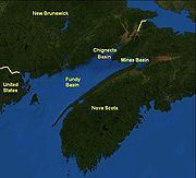
Fundy Basin
Encyclopedia
Sediment
Sediment is naturally occurring material that is broken down by processes of weathering and erosion, and is subsequently transported by the action of fluids such as wind, water, or ice, and/or by the force of gravity acting on the particle itself....
-filled rift basin
Rift
In geology, a rift or chasm is a place where the Earth's crust and lithosphere are being pulled apart and is an example of extensional tectonics....
on the Atlantic
Atlantic Ocean
The Atlantic Ocean is the second-largest of the world's oceanic divisions. With a total area of about , it covers approximately 20% of the Earth's surface and about 26% of its water surface area...
coast of southeastern Canada
Canada
Canada is a North American country consisting of ten provinces and three territories. Located in the northern part of the continent, it extends from the Atlantic Ocean in the east to the Pacific Ocean in the west, and northward into the Arctic Ocean...
. It contains three sub-basins; the Fundy sub-basin, the Minas Basin
Minas Basin
The Minas Basin is an inlet of the Bay of Fundy and a sub-basin of the Fundy Basin located in Nova Scotia, Canada. It is known for its extremely high tides.- Geography :- Boundary :...
and the Chignecto Basin
Chignecto Basin
The Chignecto Basin is a basin between New Brunswick and Nova Scotia of southeastern Canada. It is a sub-basin of the Fundy Basin.-References:...
. These arms meet at the Bay of Fundy
Bay of Fundy
The Bay of Fundy is a bay on the Atlantic coast of North America, on the northeast end of the Gulf of Maine between the Canadian provinces of New Brunswick and Nova Scotia, with a small portion touching the U.S. state of Maine...
, which is contained within the rift valley. From the Bay of Fundy, the Minas Basin trends northeast to Nova Scotia
Nova Scotia
Nova Scotia is one of Canada's three Maritime provinces and is the most populous province in Atlantic Canada. The name of the province is Latin for "New Scotland," but "Nova Scotia" is the recognized, English-language name of the province. The provincial capital is Halifax. Nova Scotia is the...
. Chignecto Bay runs from the Bay of Fundy northwest between New Brunswick
New Brunswick
New Brunswick is one of Canada's three Maritime provinces and is the only province in the federation that is constitutionally bilingual . The provincial capital is Fredericton and Saint John is the most populous city. Greater Moncton is the largest Census Metropolitan Area...
and Nova Scotia which is separated from the waters of the Northumberland Strait
Northumberland Strait
The Northumberland Strait is a strait in the southern part of the Gulf of Saint Lawrence in eastern Canada...
by the Isthmus of Chignecto
Isthmus of Chignecto
The Isthmus of Chignecto is an isthmus bordering the Maritime provinces of New Brunswick and Nova Scotia which connects the Nova Scotia peninsula with North America....
.
The Fundy Basin is best known for the bay it contains. The Bay of Fundy
Bay of Fundy
The Bay of Fundy is a bay on the Atlantic coast of North America, on the northeast end of the Gulf of Maine between the Canadian provinces of New Brunswick and Nova Scotia, with a small portion touching the U.S. state of Maine...
is home to huge tidal changes and tidal bores. It is part of the system of Eastern North America Rift Basins
Eastern North America Rift Basins
The Eastern North America Rift Basins are a series of sediment-filled depressions created by large-scale continental extension. Their positions closely mirror the eastern coast of North America.-Geology:...
.
Geology
Approximately 220 million years ago, during the late TriassicTriassic
The Triassic is a geologic period and system that extends from about 250 to 200 Mya . As the first period of the Mesozoic Era, the Triassic follows the Permian and is followed by the Jurassic. Both the start and end of the Triassic are marked by major extinction events...
period, the supercontinent
Supercontinent
In geology, a supercontinent is a landmass comprising more than one continental core, or craton. The assembly of cratons and accreted terranes that form Eurasia qualifies as a supercontinent today.-History:...
Pangaea
Pangaea
Pangaea, Pangæa, or Pangea is hypothesized as a supercontinent that existed during the Paleozoic and Mesozoic eras about 250 million years ago, before the component continents were separated into their current configuration....
began to break apart. The focus of the rifting began somewhere between where present-day eastern North America
North America
North America is a continent wholly within the Northern Hemisphere and almost wholly within the Western Hemisphere. It is also considered a northern subcontinent of the Americas...
and north-western Africa
Africa
Africa is the world's second largest and second most populous continent, after Asia. At about 30.2 million km² including adjacent islands, it covers 6% of the Earth's total surface area and 20.4% of the total land area...
were joined.
As in all rifting environments, graben
Graben
In geology, a graben is a depressed block of land bordered by parallel faults. Graben is German for ditch. Graben is used for both the singular and plural....
s formed. Many of these grabens were created, but for some of them, extension stopped before full rifting occurred. Where only partial rifting occurred, basins formed. By definition, a basin is any area that collects sediments. These "aborted rifts" (rifts that are tectonically
Plate tectonics
Plate tectonics is a scientific theory that describes the large scale motions of Earth's lithosphere...
inactive and no longer collecting sediments) extend from Alabama
Alabama
Alabama is a state located in the southeastern region of the United States. It is bordered by Tennessee to the north, Georgia to the east, Florida and the Gulf of Mexico to the south, and Mississippi to the west. Alabama ranks 30th in total land area and ranks second in the size of its inland...
to Newfoundland.
Along certain basins, rifting was not partial. Where full rifting occurred, the Atlantic Ocean
Atlantic Ocean
The Atlantic Ocean is the second-largest of the world's oceanic divisions. With a total area of about , it covers approximately 20% of the Earth's surface and about 26% of its water surface area...
was created. It is important to note that along these rifts, magmatic activity never stopped, as shown by the ongoing eruption of lava along the Mid-Atlantic Ridge
Mid-Atlantic Ridge
The Mid-Atlantic Ridge is a mid-ocean ridge, a divergent tectonic plate boundary located along the floor of the Atlantic Ocean, and part of the longest mountain range in the world. It separates the Eurasian Plate and North American Plate in the North Atlantic, and the African Plate from the South...
.
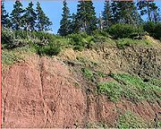
The Fundy Basin is one in a series of these failed rifts. During its rupture, tholeiitic basaltic lava
Lava
Lava refers both to molten rock expelled by a volcano during an eruption and the resulting rock after solidification and cooling. This molten rock is formed in the interior of some planets, including Earth, and some of their satellites. When first erupted from a volcanic vent, lava is a liquid at...
erupted, producing a sequence of continental tholeiitic basalts. These tholeiitic basalts form a volcanic mountain range
Mountain range
A mountain range is a single, large mass consisting of a succession of mountains or narrowly spaced mountain ridges, with or without peaks, closely related in position, direction, formation, and age; a component part of a mountain system or of a mountain chain...
known as North Mountain
North Mountain (Nova Scotia)
North Mountain is a narrow southwest-northeast trending volcanic mountain range on the mainland portion of southwestern Nova Scotia, stretching from Brier Island to Cape Split...
.
See also
- Volcanism of Canada
- Volcanism of Eastern CanadaVolcanism of Eastern CanadaVolcanism of Eastern Canada has led to the formation of hundreds of volcanic areas and extensive lava formations, indicating volcanism played a major role in shaping its surface. The region's different volcano and lava types originate from different tectonic settings and types of volcanic...
- Geography of New BrunswickGeography of New BrunswickNew Brunswick is one of Canada's three Maritime provinces, and the only officially bilingual province in the country. Its capital is Fredericton.-Physical geography:...
- Geography of Nova ScotiaGeography of Nova ScotiaNova Scotia is a province located in eastern Canada fronting the Atlantic Ocean. One of the Maritime Provinces, Nova Scotia's geography is complex, despite its relatively small size in comparison to other Canadian provinces.-Physical geography:...