
James Bay
Encyclopedia
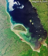
James Bay is a large body of water on the southern end of Hudson Bay
in Canada
. Both bodies of water extend from the Arctic Ocean
. James Bay borders the provinces of Quebec
and Ontario
; islands within the bay (the largest of which is Akimiski Island
) are part of Nunavut
. The James Bay watershed is the site of several major hydroelectric
projects, and is also a destination for river-based recreation. Several communities are located near or alongside James Bay, including a number of Aboriginal
communities such as the Kashechewan First Nation
and nine communities affiliated with the Crees
of northern Quebec.
As with the rest of Hudson Bay the waters of James Bay routinely freeze over in winter. The waters of James Bay are the closest of any seawater to the equator
that freeze over in winter.
entered it during his exploration of the larger bay that bears his name. James Bay itself received its name in honour of Thomas James
, an English captain
who explored the area more thoroughly in 1630 – 1631.
James Bay is important in the history of Canada
as one of the most hospitable parts of the Hudson Bay region (despite its low human population), and as a result its corresponding importance to the Hudson's Bay Company
and British expansion into Canada
. The fur-trapping duo of explorers Pierre-Esprit Radisson
and Médard des Groseilliers
convinced the English Crown, primarily Prince Rupert
of Bavaria, a favoured cousin of both Charles I
and Charles II
, that a colonial enterprise in the north
would yield wealth in minerals and fur. Des Groseilliers accompanied Captain Zachariah Gillam on the ketch
Nonsuch
and they jointly founded the first fur-trading post on James Bay, Charles Fort. Their success, though lacking in minerals, was such that the company was chartered by Charles II on their return. This charter granted a complete trading monopoly of the whole Hudson Bay basin (including James Bay) to the company. At the same time, the first English colony on what is now mainland Canada, Rupert's Land
, was formed, with the first "capital" being at Charles Fort. The fact that the first colonial governor, Charles Baley (various spellings exist, including, but not limited to "Bailey"), was a Quaker
might have been an important factor in the style of relations established between the company and its "trading partners", Canada's First Nations
.
Significant fur trapping has continued in the region, but in general the east coast or East Main of James Bay was too easily accessed by French and independent traders from the south so early Hudson's Bay Company emphasis was quickly placed onto interior trapping grounds reached from the west coasts of James and Hudson Bays. It was, nevertheless, the gateway to British settlements in what would become Manitoba
(Winnipeg, (for example) and as far west as the Rocky Mountains
.
 James Bay represents the southern extent of the Arctic Archipelago Marine
ecozone
. While the coastal areas are primarily in the Hudson Plains
, the northeastern coast bordering Quebec is in the Taiga Shield
ecozone. This rocky and hilly eastern shore forms the western edge of the Canadian Shield
in Quebec and as such the main habitat is boreal forest
of the Eastern Canadian Shield taiga
ecoregion
. The western shore however is characterised by broad tundra
lowlands that are an extension of the Hudson Bay Lowlands
and the vegetation is mostly muskeg
bog. A large portion of this area is part of the Polar Bear Provincial Park
.
Hundreds of rivers flow into James Bay. The geography of the region gives many of them similar characteristics. They tend to be wide and shallow near the Bay (in the James Bay Lowlands), whereas they are steeper and narrower further upstream (as they pour off the Canadian Shield
). For a larger list of waterways in the region, see list of Hudson Bay rivers.
s flow into James Bay. About 238 km2 is protected under the Migratory Birds Convention Act
of Canada as the Hannah Bay Bird Sanctuary
. This sanctuary has also been designated as a Wetland of International Importance
under the Ramsar Convention
since May 1987.
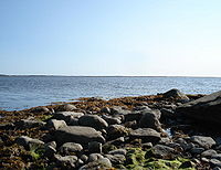
The shores in this area are a mixture of intertidal mud
, sand, and salt flats, estuarine waters
, intertidal marsh
es, freshwater ponds, swamp
s, and forested peat
lands.
, the indigenous people
of the region (from south to north):
On the western shore in Ontario there are five coastal communities (from south to north):
.jpg) Since 1971, the government of Quebec has built hydroelectric dams on rivers in the James Bay watershed, notably La Grande
Since 1971, the government of Quebec has built hydroelectric dams on rivers in the James Bay watershed, notably La Grande
and Eastmain
rivers. Built between 1974 and 1996, the James Bay Project
now has a combined generating capacity of 16,021 MW
and produces about 83,000,000,000 kWh of electricity each year, about half of Quebec's consumption. Power is also exported to the United States
via a direct transmission high voltage line. The James Bay Project continues to expand, with work that began in 2010 on a new phase that involves the diversion of the Rupert River
.
A proposed development project, the Great Recycling and Northern Development Canal
, centres on constructing a large dike to separate southern James Bay from Hudson Bay. This would turn the bay into a freshwater lake, due to the numerous rivers that empty into it. The main benefit expected from this would be to redirect this freshwater for human use. It seems very unlikely that the GRAND Canal will actually ever be built.
Two less-travelled rivers are the Groundhog River and the Harricana
. The Groundhog is less travelled in modern times due to a series of seven dams that are about a day or two up-river from the Moose. Canoeists can contact the dam company and arrange to be towed around the dams on company trucks, but they must make arrangements specific to the hour, and they cannot be late. The Groundhog flows into the Mattagami
after a set of rapids known as Seven-Mile. The Mattagami then flows into the Moose; it is at the meeting of the Missinaibi and Mattagami rivers that the Moose river begins, marked by an island known as Portage Island. This point is about two or three days travel by canoe to Moosonee. Though the Missinaibi and the Groundhog are both fairly high in the summer, the Moose is often quite low. Depending on the tides, groups have had to walk long stretches of the river. Rapids on the Groundhog tend to be bigger and more technical than those on the Missinaibi, but the campsites are few and poor, because the volume of travel is so much less.
The Harricana River flows into James Bay several miles east of Moosonee
, so anyone wishing to take this route must allow about two days to cross the bay, an extremely dangerous proposition if the tides and the weather are unfavourable.
The most common access point for paddlers to this area is Moosonee, at the southern end of James Bay. A campsite at Tidewater Provincial Park
provides large campgrounds with firepits and outhouses on an island across the river from the town. Water taxis will ferry people back and forth for about C$
10 each. Many of these rivers finish near Moosonee, and paddlers can take the Polar Bear Express
train south to Cochrane
at the end of a trip. This train regularly features a 'canoe car' enabling paddlers to travel with their canoes.
Waskaganish
, Quebec
, is a town further to the north and east on James Bay. It is accessible via the James Bay Road, and is the most common end point for trips on the Broadback, Pontax, and Rupert rivers (the town itself is situated at the mouth of the Rupert).
Hudson Bay
Hudson Bay , sometimes called Hudson's Bay, is a large body of saltwater in northeastern Canada. It drains a very large area, about , that includes parts of Ontario, Quebec, Saskatchewan, Alberta, most of Manitoba, southeastern Nunavut, as well as parts of North Dakota, South Dakota, Minnesota,...
in Canada
Canada
Canada is a North American country consisting of ten provinces and three territories. Located in the northern part of the continent, it extends from the Atlantic Ocean in the east to the Pacific Ocean in the west, and northward into the Arctic Ocean...
. Both bodies of water extend from the Arctic Ocean
Arctic Ocean
The Arctic Ocean, located in the Northern Hemisphere and mostly in the Arctic north polar region, is the smallest and shallowest of the world's five major oceanic divisions...
. James Bay borders the provinces of Quebec
Quebec
Quebec or is a province in east-central Canada. It is the only Canadian province with a predominantly French-speaking population and the only one whose sole official language is French at the provincial level....
and Ontario
Ontario
Ontario is a province of Canada, located in east-central Canada. It is Canada's most populous province and second largest in total area. It is home to the nation's most populous city, Toronto, and the nation's capital, Ottawa....
; islands within the bay (the largest of which is Akimiski Island
Akimiski Island
Akimiski Island is the largest island in James Bay , Canada, which is part of the Qikiqtaaluk Region of the territory of Nunavut. It has an area of , making it the 163rd largest island in the world, and Canada's 29th largest island. Akimiski Island is only from the province of Ontario...
) are part of Nunavut
Nunavut
Nunavut is the largest and newest federal territory of Canada; it was separated officially from the Northwest Territories on April 1, 1999, via the Nunavut Act and the Nunavut Land Claims Agreement Act, though the actual boundaries had been established in 1993...
. The James Bay watershed is the site of several major hydroelectric
Hydroelectricity
Hydroelectricity is the term referring to electricity generated by hydropower; the production of electrical power through the use of the gravitational force of falling or flowing water. It is the most widely used form of renewable energy...
projects, and is also a destination for river-based recreation. Several communities are located near or alongside James Bay, including a number of Aboriginal
Aboriginal peoples in Canada
Aboriginal peoples in Canada comprise the First Nations, Inuit and Métis. The descriptors "Indian" and "Eskimo" have fallen into disuse in Canada and are commonly considered pejorative....
communities such as the Kashechewan First Nation
Kashechewan First Nation
The Kashechewan First Nation is a Cree First Nation located near James Bay in Northern Ontario, Canada. The community is located on the northern shore of the Albany River. Kashechewan First Nation is one of two communities that were established from Old Fort Albany in the 1950s...
and nine communities affiliated with the Crees
Grand Council of the Crees
The Grand Council of the Crees , or the GCC, is the political body that represents the approximately 16,357 Crees or “Iyyu” / “Iynu” of the Eeyou Istchee territory in the James Bay and Nunavik regions of Northern Quebec, Canada...
of northern Quebec.
As with the rest of Hudson Bay the waters of James Bay routinely freeze over in winter. The waters of James Bay are the closest of any seawater to the equator
Equator
An equator is the intersection of a sphere's surface with the plane perpendicular to the sphere's axis of rotation and containing the sphere's center of mass....
that freeze over in winter.
History
The bay first came to the attention of Europeans in 1610, when Henry HudsonHenry Hudson
Henry Hudson was an English sea explorer and navigator in the early 17th century. Hudson made two attempts on behalf of English merchants to find a prospective Northeast Passage to Cathay via a route above the Arctic Circle...
entered it during his exploration of the larger bay that bears his name. James Bay itself received its name in honour of Thomas James
Thomas James (sea captain)
Captain Thomas James was an English sea captain, notable as a navigator and explorer, who set out to discover the Northwest Passage, the hoped for ocean route around the top of North America to Asia....
, an English captain
Captain (nautical)
A sea captain is a licensed mariner in ultimate command of the vessel. The captain is responsible for its safe and efficient operation, including cargo operations, navigation, crew management and ensuring that the vessel complies with local and international laws, as well as company and flag...
who explored the area more thoroughly in 1630 – 1631.
James Bay is important in the history of Canada
History of Canada
The history of Canada covers the period from the arrival of Paleo-Indians thousands of years ago to the present day. Canada has been inhabited for millennia by distinctive groups of Aboriginal peoples, among whom evolved trade networks, spiritual beliefs, and social hierarchies...
as one of the most hospitable parts of the Hudson Bay region (despite its low human population), and as a result its corresponding importance to the Hudson's Bay Company
Hudson's Bay Company
The Hudson's Bay Company , abbreviated HBC, or "The Bay" is the oldest commercial corporation in North America and one of the oldest in the world. A fur trading business for much of its existence, today Hudson's Bay Company owns and operates retail stores throughout Canada...
and British expansion into Canada
Canada under British Imperial Control (1764-1867)
Territories, colonies and provinces that would become part of modern Canada were under control of the English, and later British, Empire from the sixteenth century, when France also had claims in the area. However, the most populous areas of Canada in the St...
. The fur-trapping duo of explorers Pierre-Esprit Radisson
Pierre-Esprit Radisson
Pierre-Esprit Radisson was a French-Canadian fur trader and explorer. He is often linked to his brother-in-law Médard des Groseilliers who was about 20 years older. The decision of Radisson and Groseilliers to enter the English service led to the formation of the Hudson's Bay Company.Born near...
and Médard des Groseilliers
Médard des Groseilliers
Médard Chouart des Groseilliers was a French explorer and fur trader in Canada. He is often paired with his brother-in-law Pierre-Esprit Radisson who was about 20 years his junior...
convinced the English Crown, primarily Prince Rupert
Prince Rupert of the Rhine
Rupert, Count Palatine of the Rhine, Duke of Bavaria, 1st Duke of Cumberland, 1st Earl of Holderness , commonly called Prince Rupert of the Rhine, KG, FRS was a noted soldier, admiral, scientist, sportsman, colonial governor and amateur artist during the 17th century...
of Bavaria, a favoured cousin of both Charles I
Charles I of England
Charles I was King of England, King of Scotland, and King of Ireland from 27 March 1625 until his execution in 1649. Charles engaged in a struggle for power with the Parliament of England, attempting to obtain royal revenue whilst Parliament sought to curb his Royal prerogative which Charles...
and Charles II
Charles II of England
Charles II was monarch of the three kingdoms of England, Scotland, and Ireland.Charles II's father, King Charles I, was executed at Whitehall on 30 January 1649, at the climax of the English Civil War...
, that a colonial enterprise in the north
Northern Canada
Northern Canada, colloquially the North, is the vast northernmost region of Canada variously defined by geography and politics. Politically, the term refers to the three territories of Canada: Yukon, Northwest Territories, and Nunavut...
would yield wealth in minerals and fur. Des Groseilliers accompanied Captain Zachariah Gillam on the ketch
Ketch
A ketch is a sailing craft with two masts: a main mast, and a shorter mizzen mast abaft of the main mast, but forward of the rudder post. Both masts are rigged mainly fore-and-aft. From one to three jibs may be carried forward of the main mast when going to windward...
Nonsuch
Nonsuch (ship)
The Nonsuch was the ketch that sailed into Hudson Bay in 1668-1669 under Zachariah Gillam, in the first trading voyage for what was to become the Hudson's Bay Company two years later. Originally built as a merchant ship in 1650, and later the Royal Navy ketch HMS Nonsuch, the vessel was sold to Sir...
and they jointly founded the first fur-trading post on James Bay, Charles Fort. Their success, though lacking in minerals, was such that the company was chartered by Charles II on their return. This charter granted a complete trading monopoly of the whole Hudson Bay basin (including James Bay) to the company. At the same time, the first English colony on what is now mainland Canada, Rupert's Land
Rupert's Land
Rupert's Land, or Prince Rupert's Land, was a territory in British North America, consisting of the Hudson Bay drainage basin that was nominally owned by the Hudson's Bay Company for 200 years from 1670 to 1870, although numerous aboriginal groups lived in the same territory and disputed the...
, was formed, with the first "capital" being at Charles Fort. The fact that the first colonial governor, Charles Baley (various spellings exist, including, but not limited to "Bailey"), was a Quaker
Religious Society of Friends
The Religious Society of Friends, or Friends Church, is a Christian movement which stresses the doctrine of the priesthood of all believers. Members are known as Friends, or popularly as Quakers. It is made of independent organisations, which have split from one another due to doctrinal differences...
might have been an important factor in the style of relations established between the company and its "trading partners", Canada's First Nations
First Nations
First Nations is a term that collectively refers to various Aboriginal peoples in Canada who are neither Inuit nor Métis. There are currently over 630 recognised First Nations governments or bands spread across Canada, roughly half of which are in the provinces of Ontario and British Columbia. The...
.
Significant fur trapping has continued in the region, but in general the east coast or East Main of James Bay was too easily accessed by French and independent traders from the south so early Hudson's Bay Company emphasis was quickly placed onto interior trapping grounds reached from the west coasts of James and Hudson Bays. It was, nevertheless, the gateway to British settlements in what would become Manitoba
Manitoba
Manitoba is a Canadian prairie province with an area of . The province has over 110,000 lakes and has a largely continental climate because of its flat topography. Agriculture, mostly concentrated in the fertile southern and western parts of the province, is vital to the province's economy; other...
(Winnipeg, (for example) and as far west as the Rocky Mountains
Rocky Mountains
The Rocky Mountains are a major mountain range in western North America. The Rocky Mountains stretch more than from the northernmost part of British Columbia, in western Canada, to New Mexico, in the southwestern United States...
.
Geography
Arctic Archipelago Marine
The Arctic Archipelago Marine Ecozone is a marine ecozone in the Canadian arctic, encompassing Hudson Bay, James Bay, the internal waters and some shores of the islands in the Canadian Arctic Archipelago, and the shores of the territories, northern Ontario and western Quebec...
ecozone
Ecozones of Canada
The ecozones of Canada consist of fifteen terrestrial and five marine ecozones in Canada. These are further subdivided into 53 ecoprovinces, 194 ecoregions, and 1021 ecodistricts...
. While the coastal areas are primarily in the Hudson Plains
Hudson Plains
The Hudson Plains Ecozone is a sparsely populated Canadian subarctic ecozone extending from the western coast of Quebec to the coast of Manitoba, encompassing all coastal areas of James Bay and those of southern Hudson Bay, stretching to about 50°N latitude. It includes the largest continuous...
, the northeastern coast bordering Quebec is in the Taiga Shield
Taiga Shield
The Taiga Shield Ecozone is an ecozone which stretches across Canada's subarctic region. Some regions exhibit exposed Precambrian bedrock of the Canadian Shield, the oldest of the world's geological formations...
ecozone. This rocky and hilly eastern shore forms the western edge of the Canadian Shield
Canadian Shield
The Canadian Shield, also called the Laurentian Plateau, or Bouclier Canadien , is a vast geological shield covered by a thin layer of soil that forms the nucleus of the North American or Laurentia craton. It is an area mostly composed of igneous rock which relates to its long volcanic history...
in Quebec and as such the main habitat is boreal forest
Taiga
Taiga , also known as the boreal forest, is a biome characterized by coniferous forests.Taiga is the world's largest terrestrial biome. In North America it covers most of inland Canada and Alaska as well as parts of the extreme northern continental United States and is known as the Northwoods...
of the Eastern Canadian Shield taiga
Eastern Canadian Shield taiga
The Eastern Canadian Shield taiga is an ecoregion of Canada as defined by the World Wildlife Fund categorization system.-Setting:Located in northeastern Canada, this ecoregion covers a large part of northern Quebec and most of Labrador, reaching from Hudson Bay and James Bay in the west, across to...
ecoregion
Ecoregion
An ecoregion , sometimes called a bioregion, is an ecologically and geographically defined area that is smaller than an ecozone and larger than an ecosystem. Ecoregions cover relatively large areas of land or water, and contain characteristic, geographically distinct assemblages of natural...
. The western shore however is characterised by broad tundra
Tundra
In physical geography, tundra is a biome where the tree growth is hindered by low temperatures and short growing seasons. The term tundra comes through Russian тундра from the Kildin Sami word tūndâr "uplands," "treeless mountain tract." There are three types of tundra: Arctic tundra, alpine...
lowlands that are an extension of the Hudson Bay Lowlands
Hudson Bay Lowlands
The Hudson Bay Lowlands is a large, poorly drained piece of wetlands wedged between the Canadian Shield and southern shores of Hudson Bay and James Bay. Many wide and slow-moving rivers flow through this area toward the salt water of Hudson Bay. Mosquitoes and black flies thrive here. This is a...
and the vegetation is mostly muskeg
Muskeg
Muskeg is an acidic soil type common in Arctic and boreal areas, although it is found in other northern climates as well. Muskeg is approximately synonymous with bogland but muskeg is the standard term in Western Canada and Alaska, while 'bog' is common elsewhere. The term is of Cree origin, maskek...
bog. A large portion of this area is part of the Polar Bear Provincial Park
Polar Bear Provincial Park
Polar Bear Provincial Park is an isolated wilderness park in the far north of Ontario, Canada. It lies on the western shore where James Bay joins Hudson Bay. The terrain is part of the Hudson Bay Lowlands and features unspoiled low-lying tundra in the Hudson Plains ecozone.Administered by Ontario...
.
Hundreds of rivers flow into James Bay. The geography of the region gives many of them similar characteristics. They tend to be wide and shallow near the Bay (in the James Bay Lowlands), whereas they are steeper and narrower further upstream (as they pour off the Canadian Shield
Canadian Shield
The Canadian Shield, also called the Laurentian Plateau, or Bouclier Canadien , is a vast geological shield covered by a thin layer of soil that forms the nucleus of the North American or Laurentia craton. It is an area mostly composed of igneous rock which relates to its long volcanic history...
). For a larger list of waterways in the region, see list of Hudson Bay rivers.
Hannah Bay
Hannah Bay is the southernmost bay of James Bay. Here the Kesagami and Harricana RiverHarricana River
The Harricana River is a river in western Quebec and northeastern Ontario, Canada. It is long, has a drainage area of , and has a mean discharge of 570 m³/s...
s flow into James Bay. About 238 km2 is protected under the Migratory Birds Convention Act
Migratory Birds Convention Act
The Migratory Birds Convention Act is a Canadian law established in 1917 and significantly updated in June 1994 which contains regulations to protect migratory birds, their eggs, and their nests from hunting, trafficking and commercialization...
of Canada as the Hannah Bay Bird Sanctuary
Southern James Bay
Southern James Bay is a Canadian coastal wetland complex in northeastern Ontario bordering James Bay and Quebec. It was designated as a wetland of international importance via the Ramsar Convention on May 27, 1987...
. This sanctuary has also been designated as a Wetland of International Importance
Ramsar list of wetlands of international importance
This is the list of wetlands of international importance as defined by the Ramsar Convention for the conservation and sustainable utilization of wetlands, recognizing the fundamental ecological functions of wetlands and their economic, cultural, scientific, and recreational value.The Convention...
under the Ramsar Convention
Ramsar Convention
The Ramsar Convention is an international treaty for the conservation and sustainable utilization of wetlands, i.e., to stem the progressive encroachment on and loss of wetlands now and in the future, recognizing the fundamental ecological functions of wetlands and their economic, cultural,...
since May 1987.
The shores in this area are a mixture of intertidal mud
Mudflat
Mudflats or mud flats, also known as tidal flats, are coastal wetlands that form when mud is deposited by tides or rivers. They are found in sheltered areas such as bays, bayous, lagoons, and estuaries. Mudflats may be viewed geologically as exposed layers of bay mud, resulting from deposition of...
, sand, and salt flats, estuarine waters
Estuary
An estuary is a partly enclosed coastal body of water with one or more rivers or streams flowing into it, and with a free connection to the open sea....
, intertidal marsh
Marsh
In geography, a marsh, or morass, is a type of wetland that is subject to frequent or continuous flood. Typically the water is shallow and features grasses, rushes, reeds, typhas, sedges, other herbaceous plants, and moss....
es, freshwater ponds, swamp
Swamp
A swamp is a wetland with some flooding of large areas of land by shallow bodies of water. A swamp generally has a large number of hammocks, or dry-land protrusions, covered by aquatic vegetation, or vegetation that tolerates periodical inundation. The two main types of swamp are "true" or swamp...
s, and forested peat
Peat
Peat is an accumulation of partially decayed vegetation matter or histosol. Peat forms in wetland bogs, moors, muskegs, pocosins, mires, and peat swamp forests. Peat is harvested as an important source of fuel in certain parts of the world...
lands.
Human development
Coastal communities
The shores of James Bay are sparsely populated. On the eastern shore in Quebec there are four coastal communities belonging to the CreesGrand Council of the Crees
The Grand Council of the Crees , or the GCC, is the political body that represents the approximately 16,357 Crees or “Iyyu” / “Iynu” of the Eeyou Istchee territory in the James Bay and Nunavik regions of Northern Quebec, Canada...
, the indigenous people
Aboriginal peoples in Canada
Aboriginal peoples in Canada comprise the First Nations, Inuit and Métis. The descriptors "Indian" and "Eskimo" have fallen into disuse in Canada and are commonly considered pejorative....
of the region (from south to north):
- WaskaganishWaskaganish, QuebecWaskaganish is a Cree village of about 2000 people at the mouth of the Rupert River on the south-east shore of James Bay in the Eeyou Istchee territory in Northern Quebec, Canada...
- EastmainEastmain, QuebecEastmain is a Cree community located on James Bay at the mouth of the Eastmain River, Quebec, Canada. It is the smallest of the coastal Cree villages with a population of 606 people...
- WemindjiWemindji, QuebecWemindji is a small Cree community on Paint Hills Bay off James Bay at the mouth of the Maquatua River in Quebec, Canada. The community has a population of 1238 people ....
- ChisasibiChisasibi, QuebecChisasibi is a village on the eastern shore of James Bay, in the Eeyou Istchee territory in northern Quebec, Canada. It is situated on the south shore of La Grande River , less than from the river's mouth...
On the western shore in Ontario there are five coastal communities (from south to north):
- Moose FactoryMoose Factory, OntarioMoose Factory is a community in the Cochrane District, Ontario, Canada. It is on Moose Factory Island, near the mouth of the Moose River, which is at the southern end of James Bay. It was the first English-speaking settlement in Ontario and the second Hudson's Bay Company post to be set up in North...
- MoosoneeMoosonee, OntarioMoosonee is a town in northern Ontario, Canada, on the Moose River approximately south of James Bay. It is considered as "the Gateway to the Arctic" and has Ontario's only saltwater port...
- Fort AlbanyFort Albany, OntarioFort Albany First Nation is a community in within the Cochrane District of Northern Ontario, Canada. Situated on the southern shore of the Albany River, Fort Albany First Nation is only accessible by air or by winter road....
- KashechewanKashechewan First NationThe Kashechewan First Nation is a Cree First Nation located near James Bay in Northern Ontario, Canada. The community is located on the northern shore of the Albany River. Kashechewan First Nation is one of two communities that were established from Old Fort Albany in the 1950s...
- AttawapiskatAttawapiskat First NationAttawapiskat First Nation is an isolated First Nation located in Kenora District in northern Ontario, Canada, at the mouth of the Attawapiskat River at James Bay...
Economic development
La Grande River
La Grande River is a river in northwestern Quebec, Canada, which rises in the highlands of north central Quebec and flows roughly west to drain into James Bay. It is the second largest river in Quebec, surpassed only by the Saint Lawrence River....
and Eastmain
Eastmain River
The Eastmain River is a river in northwestern Quebec which rises in north central Quebec and flows 800 km west to drain into James Bay. 'East Main' is an old name for the east side of James Bay. This river drains an area of 46,400 km²...
rivers. Built between 1974 and 1996, the James Bay Project
James Bay Project
The James Bay Project is a series of hydroelectric development with a combined installed capacity of over 16,000 megawatts built since 1974 for Hydro-Québec by the on the La Grande and other rivers of Northern Quebec....
now has a combined generating capacity of 16,021 MW
Watt
The watt is a derived unit of power in the International System of Units , named after the Scottish engineer James Watt . The unit, defined as one joule per second, measures the rate of energy conversion.-Definition:...
and produces about 83,000,000,000 kWh of electricity each year, about half of Quebec's consumption. Power is also exported to the United States
United States
The United States of America is a federal constitutional republic comprising fifty states and a federal district...
via a direct transmission high voltage line. The James Bay Project continues to expand, with work that began in 2010 on a new phase that involves the diversion of the Rupert River
Rupert River
The Rupert River is one of the largest rivers in Quebec, Canada. From its headwaters in Lake Mistassini, the largest natural lake in Québec, it flows west into Rupert Bay on James Bay. The Rupert drains an area of . There is some extremely large whitewater on the river, but paddlers can avoid...
.
A proposed development project, the Great Recycling and Northern Development Canal
Great Recycling and Northern Development Canal
The Great Recycling and Northern Development Canal of North America or GCNA is a water management proposal designed by Newfoundland engineer Thomas Kierans to alleviate North American freshwater shortage problems...
, centres on constructing a large dike to separate southern James Bay from Hudson Bay. This would turn the bay into a freshwater lake, due to the numerous rivers that empty into it. The main benefit expected from this would be to redirect this freshwater for human use. It seems very unlikely that the GRAND Canal will actually ever be built.
Canoeing
Many of the rivers flowing into James Bay are popular destinations for wilderness canoe-trippers. Among the more popular rivers are:- Albany RiverAlbany RiverThe Albany River is a river in Northern Ontario, Canada, which flows northeast from Lake St. Joseph in Northwestern Ontario and empties into James Bay. It is long to the head of the Cat River, tying it with the Severn River for the title of longest river in Ontario...
(Ontario) - Moose RiverMoose River (Ontario)The Moose River is a Canadian river in the Hudson Plains ecozone of northern Ontario which flows 100 km northeast from the junction of the Mattagami and Missinaibi Rivers into James Bay. Its drainage basin is 108,500 km² and it has a mean discharge rate of 1370 m³/s. Its full length...
(Ontario) - Missinaibi RiverMissinaibi RiverThe Missinaibi River is a river in northern Ontario, Canada, which flows northeast from Missinaibi Lake, north of Chapleau, and empties into the Moose River, which drains into James Bay. This river is in length...
(Ontario) - recognised as a Canadian Heritage RiverCanadian Heritage Rivers SystemThe Canadian Heritage Rivers System was established in 1984 by the federal, provincial and territorial governments to conserve and protect the best examples of Canada's river heritage, to give them national recognition, and to encourage the public to enjoy and appreciate them. It is a cooperative... - Broadback RiverBroadback RiverThe Broadback River is a river in northern Quebec, Canada. It drains into Rupert Bay , just south of the Rupert River and Cree community Waskaganish...
(Quebec) - Rupert RiverRupert RiverThe Rupert River is one of the largest rivers in Quebec, Canada. From its headwaters in Lake Mistassini, the largest natural lake in Québec, it flows west into Rupert Bay on James Bay. The Rupert drains an area of . There is some extremely large whitewater on the river, but paddlers can avoid...
(Quebec) - diverted in 2007 for hydroelectric development and no longer a popular destination
Two less-travelled rivers are the Groundhog River and the Harricana
Harricana River
The Harricana River is a river in western Quebec and northeastern Ontario, Canada. It is long, has a drainage area of , and has a mean discharge of 570 m³/s...
. The Groundhog is less travelled in modern times due to a series of seven dams that are about a day or two up-river from the Moose. Canoeists can contact the dam company and arrange to be towed around the dams on company trucks, but they must make arrangements specific to the hour, and they cannot be late. The Groundhog flows into the Mattagami
Mattagami River
The Mattagami River is a river in the James Bay drainage basin in Cochrane District, Timiskaming District and Sudbury District in Northeastern Ontario, Canada....
after a set of rapids known as Seven-Mile. The Mattagami then flows into the Moose; it is at the meeting of the Missinaibi and Mattagami rivers that the Moose river begins, marked by an island known as Portage Island. This point is about two or three days travel by canoe to Moosonee. Though the Missinaibi and the Groundhog are both fairly high in the summer, the Moose is often quite low. Depending on the tides, groups have had to walk long stretches of the river. Rapids on the Groundhog tend to be bigger and more technical than those on the Missinaibi, but the campsites are few and poor, because the volume of travel is so much less.
The Harricana River flows into James Bay several miles east of Moosonee
Moosonee, Ontario
Moosonee is a town in northern Ontario, Canada, on the Moose River approximately south of James Bay. It is considered as "the Gateway to the Arctic" and has Ontario's only saltwater port...
, so anyone wishing to take this route must allow about two days to cross the bay, an extremely dangerous proposition if the tides and the weather are unfavourable.
The most common access point for paddlers to this area is Moosonee, at the southern end of James Bay. A campsite at Tidewater Provincial Park
Tidewater Provincial Park
Tidewater Provincial Park is a provincial park located on four islands in the Moose River estuary between Moosonee and Moose Factory, Ontario, Canada.-External links:*...
provides large campgrounds with firepits and outhouses on an island across the river from the town. Water taxis will ferry people back and forth for about C$
Canadian dollar
The Canadian dollar is the currency of Canada. As of 2007, the Canadian dollar is the 7th most traded currency in the world. It is abbreviated with the dollar sign $, or C$ to distinguish it from other dollar-denominated currencies...
10 each. Many of these rivers finish near Moosonee, and paddlers can take the Polar Bear Express
Ontario Northland Railway
The Ontario Northland Railway is a Canadian railway operated by the Ontario Northland Transportation Commission, a provincial Crown agency of the government of Ontario....
train south to Cochrane
Cochrane, Ontario
Cochrane is a town in northern Ontario, Canada. It is located east of Kapuskasing, northeast of Timmins, south of Moosonee, and north of Iroquois Falls. It is about a one-hour drive from Timmins, the major city of the region. It is the seat of Cochrane District...
at the end of a trip. This train regularly features a 'canoe car' enabling paddlers to travel with their canoes.
Waskaganish
Waskaganish, Quebec
Waskaganish is a Cree village of about 2000 people at the mouth of the Rupert River on the south-east shore of James Bay in the Eeyou Istchee territory in Northern Quebec, Canada...
, Quebec
Quebec
Quebec or is a province in east-central Canada. It is the only Canadian province with a predominantly French-speaking population and the only one whose sole official language is French at the provincial level....
, is a town further to the north and east on James Bay. It is accessible via the James Bay Road, and is the most common end point for trips on the Broadback, Pontax, and Rupert rivers (the town itself is situated at the mouth of the Rupert).
External links
- "James Bay Road website" Extensive and detailed information on the James Bay region of Quebec, a well as the James Bay and Trans-Taiga Roads.
- "The Rupert River website" Read about and see this endangered river soon to be diverted by Hydro-Québec.
- "Dammed river" special feature on James Bay from Canadian GeographicCanadian GeographicCanadian Geographic is the bimonthly magazine of the Royal Canadian Geographical Society . It was first published in May 1930 under the name Canadian Geographical Journal. The society's objective was to produce a popular magazine dealing primarily with Canadian geography...
. - CBC Digital Archives - James Bay Project and the Cree
- Northern Tidal Flows: Reliable New Power Source for Quebec? - Includes discussion of Ungava Bay as a feasible location for tidal power generation. (PESN; Aug. 14, 2006)