

Fissure vent
Encyclopedia
Lava
Lava refers both to molten rock expelled by a volcano during an eruption and the resulting rock after solidification and cooling. This molten rock is formed in the interior of some planets, including Earth, and some of their satellites. When first erupted from a volcanic vent, lava is a liquid at...
erupts, usually without any explosive activity
Explosive eruption
An explosive eruption is a volcanic term to describe a violent, explosive type of eruption. Mount St. Helens in 1980 was an example. Such an eruption is driven by gas accumulating under great pressure. Driven by hot rising magma, it interacts with ground water until the pressure increases to the...
. The vent is usually a few meters wide and may be many kilometers long. Fissure vents can cause large flood basalt
Flood basalt
A flood basalt or trap basalt is the result of a giant volcanic eruption or series of eruptions that coats large stretches of land or the ocean floor with basalt lava. Flood basalts have occurred on continental scales in prehistory, creating great plateaus and mountain ranges...
s and lava channel
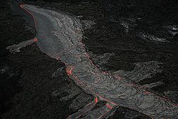
Lava channel
A lava channel is a stream of fluid lava contained within marginal zones of static lava or levees. The initial channel may not contain levees per se, until the parental flow solidifies over what develops into the channel and creates simple levees. This initial levee allows for the building of a...
s. This type of volcano is usually hard to recognize from the ground and from outer space
Outer space
Outer space is the void that exists between celestial bodies, including the Earth. It is not completely empty, but consists of a hard vacuum containing a low density of particles: predominantly a plasma of hydrogen and helium, as well as electromagnetic radiation, magnetic fields, and neutrinos....
because it has no central caldera
Caldera
A caldera is a cauldron-like volcanic feature usually formed by the collapse of land following a volcanic eruption, such as the one at Yellowstone National Park in the US. They are sometimes confused with volcanic craters...
and the surface is mostly flat. The volcano can usually be seen as a crack in the ground or on the ocean floor
Seabed
The seabed is the bottom of the ocean.- Ocean structure :Most of the oceans have a common structure, created by common physical phenomena, mainly from tectonic movement, and sediment from various sources...
. Narrow fissures can be filled in with lava that hardens. As erosion
Erosion
Erosion is when materials are removed from the surface and changed into something else. It only works by hydraulic actions and transport of solids in the natural environment, and leads to the deposition of these materials elsewhere...
removes its surroundings, the lava mass could stand above the surface as a dyke
Dike (geology)
A dike or dyke in geology is a type of sheet intrusion referring to any geologic body that cuts discordantly across* planar wall rock structures, such as bedding or foliation...
. The dykes that feed fissures reach the surface from depths of a few kilometers. Fissures are usually found in or along rift
Rift
In geology, a rift or chasm is a place where the Earth's crust and lithosphere are being pulled apart and is an example of extensional tectonics....
s and rift zone
Rift zone
A rift zone is a feature of some volcanoes, especially the shield volcanoes of Hawaii, in which a linear series of fissures in the volcanic edifice allows lava to be erupted from the volcano's flank instead of from its summit...
s, such as Iceland
Iceland
Iceland , described as the Republic of Iceland, is a Nordic and European island country in the North Atlantic Ocean, on the Mid-Atlantic Ridge. Iceland also refers to the main island of the country, which contains almost all the population and almost all the land area. The country has a population...
and the Great Rift Valley
Great Rift Valley
The Great Rift Valley is a name given in the late 19th century by British explorer John Walter Gregory to the continuous geographic trench, approximately in length, that runs from northern Syria in Southwest Asia to central Mozambique in South East Africa...
in Africa
Africa
Africa is the world's second largest and second most populous continent, after Asia. At about 30.2 million km² including adjacent islands, it covers 6% of the Earth's total surface area and 20.4% of the total land area...
. Fissure vents are often found in shield volcano
Shield volcano
A shield volcano is a type of volcano usually built almost entirely of fluid lava flows. They are named for their large size and low profile, resembling a warrior's shield. This is caused by the highly fluid lava they erupt, which travels farther than lava erupted from more explosive volcanoes...
es.
In Iceland, volcanic vents are often long fissures parallel to the rift zone where lithospheric
Lithosphere
The lithosphere is the rigid outermost shell of a rocky planet. On Earth, it comprises the crust and the portion of the upper mantle that behaves elastically on time scales of thousands of years or greater.- Earth's lithosphere :...
plates
Plate tectonics
Plate tectonics is a scientific theory that describes the large scale motions of Earth's lithosphere...
are diverging. Renewed eruptions generally occur from new parallel fractures offset by a few hundred to thousands of metres from the earlier fissures. This distribution of vents and voluminous eruptions of fluid basaltic lava usually build up a thick lava plateau rather than a single volcanic edifice. The Laki
Laki
Łąki may refer to the following places in Poland:*Łąki, Lower Silesian Voivodeship *Łąki, West Pomeranian Voivodeship *Łąki, Lublin Voivodeship...
fissure system produced the biggest eruption on earth in historical times, in the form of a flood basalt, during the Eldgjá
Eldgjá
Eldgjá is a volcanic canyon in Iceland. Eldgjá and the Katla volcano are part of the same volcanic system in the south of the country. Eldgjá means "fire canyon" in Icelandic....
eruption A.D. 934, which released 19.6 km³ (4.7 mi³) of lava.
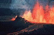
The radial fissure vents of Hawaiian volcanoes
Hawaii Volcanoes National Park
Hawaii Volcanoes National Park, established in 1916, is a United States National Park located in the U.S. State of Hawaii on the island of Hawaii. It encompasses two active volcanoes: Kīlauea, one of the world's most active volcanoes, and Mauna Loa, the world's most massive volcano...
produce “curtains of fire” as lava fountain
Lava fountain
A lava fountain is a volcanic phenomenon in which lava is forcefully but non-explosively ejected from a crater, vent, or fissure. Lava fountains may reach heights of up to . They may occur as a series of short pulses, or a continuous jet of lava. They are commonly seen in Hawaiian eruptions.-See...
s erupt along a portion of a fissure. These vents produce low ramparts of basalt
Basalt
Basalt is a common extrusive volcanic rock. It is usually grey to black and fine-grained due to rapid cooling of lava at the surface of a planet. It may be porphyritic containing larger crystals in a fine matrix, or vesicular, or frothy scoria. Unweathered basalt is black or grey...
ic spatter on both sides of the fissure. More isolated lava fountains along the fissure produce crater rows of small spatter and cinder cone
Cinder cone
According to the , Cinder Cone is the proper name of 1 cinder cone in Canada and 7 cinder cones in the United States:In Canada: Cinder Cone In the United States:...
s. The fragments that form a spatter cone are hot and plastic enough to weld together, while the fragments that form a cinder cone remain separate because of their lower temperature.
List of fissure vents
| Name | Elevation | Location | Last eruption | |
| metres | feet | Coordinates | ||
| Laki Laki Łąki may refer to the following places in Poland:*Łąki, Lower Silesian Voivodeship *Łąki, West Pomeranian Voivodeship *Łąki, Lublin Voivodeship... |
1725 | 5659 | 64.42°N 17.33°W | 1783 |
| Lanzarote Lanzarote Lanzarote , a Spanish island, is the easternmost of the autonomous Canary Islands, in the Atlantic Ocean, approximately 125 km off the coast of Africa and 1,000 km from the Iberian Peninsula. Covering 845.9 km2, it stands as the fourth largest of the islands... |
670 | 2198 | 29.03°N 13.63°W | 1824 |
| Cordón Caulle | 1798 | 5899 | 40.46°S 72.25°W | 2011? |
| São Jorge Island | 1053 | 3455 | 38.65°N 28.08°W | 1907 |
| Vatnafjöll Vatnafjöll Vatnafjöll is a long, wide basaltic fissure vent system that is located southeast of Hekla, Iceland. It is part of the same system as Hekla. More than two dozen eruptions have occurred at Vatnafjöll during the Holocene Epoch. Vatnafjöll last erupted about 1200 years ago.... |
1235 | 4052 | 63.92°N 19.67°W | 1200 BP |
| Quetena | 5730 | 18799 | 22.25°S 67.42°W | Unknown |
| Nejapa Miraflores | 360 | 1181 | 12.12°N 86.32°W | Unknown |
| Manda-Inakir Manda-Inakir Manda-Inakir is a system of fissure vents and cinder cones located along the Ethiopia-Djibouti border. It last erupted in 1928 and produced a cinder cone called Kammourta.... |
600+ | 1968 | 12.38°N 42.20°E | 1928 |
| Hertali Hertali Hertali is a fissure vent in Ethiopia. The fissure vent was believed to have been active through the late Pleistocene to Holocene.... |
900? | 2953 | 9.78°N 40.33°E | Unknown |
| Gran Canaria Gran Canaria Gran Canaria is the second most populous island of the Canary Islands, with a population of 838,397 which constitutes approximately 40% of the population of the archipelago... |
1950 | 6350 | 28.00°N 15.58°W | less than 1000 BP |
| Fuerteventura Fuerteventura Fuerteventura , a Spanish island, is one of the Canary Islands, in the Atlantic Ocean off the coast of Africa. It is situated at 28°20' north, 14°00' west. At 1,660 km² it is the second largest of the Canary Islands, after Tenerife... |
529 | 1736 | 28.358°N 14.02°W | Unknown |
| Estelí Estelí Estelí, officially Villa de San Antonio de Pavia de Estelí is a city and municipality within the Estelí department. It is the third largest city in Nicaragua, an active commercial center in the north and is known as "the Diamond of the Segovias."... |
899 | 2949 | 13.17°N 86.40°W | Unknown |
| Butajiri Silti Field | 2281 | 7484 | 8.05°N 83.85°E | Unknown |
| Bishoftu Volcanic Field | 1850+ | 6069 | 8.78°N 38.98°E | Unknown |
| Alu | 429 | 1407 | 13.82°N 40.55°E | Unknown |
| Singu Plateau Singu Plateau The Singu Plateau is a volcanic plateau located in central Burma. The lavas that form the plateau originally came from fissure vents during the Holocene, although the last eruption is unknown.... |
507 | 1663 | 22.70°N 95.98°E | Unknown |
| Ray Mountain Ray Mountain Ray Mountain is a subglacial mound in Wells Gray Provincial Park, British Columbia, Canada. Ray Mountain last erupted during the Pleistocene. It is part of the Wells Gray-Clearwater volcanic field.... |
2050 | - | 52.23°N 120.12°W | Pleistocene |
| Eldgjá Eldgjá Eldgjá is a volcanic canyon in Iceland. Eldgjá and the Katla volcano are part of the same volcanic system in the south of the country. Eldgjá means "fire canyon" in Icelandic.... |
800 | 2625 | 63.88°N 18.77°W | 934 |