
Mount Silverthrone
Encyclopedia
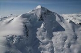
Mount Silverthrone, officially named Silverthrone Mountain, is a mountain
in the Regional District of Mount Waddington, British Columbia
, located over 320 km (198.8 mi) northwest of the city of Vancouver
and about 50 km (31.1 mi) west of Mount Waddington
, British Columbia
, Canada
. It is the highest peak in the Ha-Iltzuk Icefield
, which is the largest icefield in the Coast Mountains
south of the Alaska Panhandle
.
on the northeast edge of a large caldera
complex called the Silverthrone Caldera
. It lies within the Coast Plutonic Complex, which is the single largest contiguous granite
outcropping in the world. The plutonic
and metamorphic rock
s extend approximately 1,800 kilometers on the coast of British Columbia, southwestern Yukon
and southeastern Alaska
. In addition, Garibaldi
, Meager
, Cayley
and Silverthrone areas are of recent volcanic origin. The volcanic terrain in the Silverthrone area is very similar to the Mount Meager
volcanic complex further south. However, there is much more ice.
Mount Silverthrone is perhaps one the most heavily glaciated
volcanic peaks in southwestern British Columbia. It has a topographic prominence
of approximately 975 m (3,198.8 ft), greater than any other volcano in southwestern British Columbia. The extensive icefields around Mount Silverthrone are receding and are small compared to their former extent, but they are an impressive indication of how much of British Columbia looked 10,000 years or more ago. Silverthrone contains one of the few calderas buried beneath the ice caps of western Canada, another example being Mount Edziza
in far northwestern British Columbia.
and Phyllis Munday
in 1936 by walking up the Klinaklini Glacier
from the head of Knight Inlet
. Because Silverthrone is heavily glaciated, Don Munday
called the mountain "home of the snows".
Skiing
on Mount Silverthrone includes skiing on the largest ice field in the southern Coast Mountains, the Ha-Iltzuk Icefield. It is skiable over 1500 m (4,921.3 ft), possibly over 2700 m (8,858.3 ft) down to the Pacific Ocean
. The easiest access to Mount Silverthrone is by air travel, starting from the rural community of Tatla Lake
, landing on the major part of the Ha-Iltzuk Icefield. Air travels can also be made into logging
camps at Owikeno Lake
to the west or at the start of Knight Inlet
to the southwest, followed by long hiking and skiing methods.
Mountain
Image:Himalaya_annotated.jpg|thumb|right|The Himalayan mountain range with Mount Everestrect 58 14 160 49 Chomo Lonzorect 200 28 335 52 Makalurect 378 24 566 45 Mount Everestrect 188 581 920 656 Tibetan Plateaurect 250 406 340 427 Rong River...
in the Regional District of Mount Waddington, British Columbia
Regional District of Mount Waddington, British Columbia
The Regional District of Mount Waddington is a regional district in British Columbia. It takes in the lower Central Coast region centred around the Queen Charlotte Strait coast of northern Vancouver Island and the adjoining parts of mainland British Columbia...
, located over 320 km (198.8 mi) northwest of the city of Vancouver
Vancouver
Vancouver is a coastal seaport city on the mainland of British Columbia, Canada. It is the hub of Greater Vancouver, which, with over 2.3 million residents, is the third most populous metropolitan area in the country,...
and about 50 km (31.1 mi) west of Mount Waddington
Mount Waddington
Mount Waddington, once known as Mystery Mountain, is the highest peak in the Coast Mountains of British Columbia, Canada. Although Mount Fairweather and Mount Quincy Adams, which straddle the US border between Alaska and British Columbia are taller, Mount Waddington is the highest peak that lies...
, British Columbia
British Columbia
British Columbia is the westernmost of Canada's provinces and is known for its natural beauty, as reflected in its Latin motto, Splendor sine occasu . Its name was chosen by Queen Victoria in 1858...
, Canada
Canada
Canada is a North American country consisting of ten provinces and three territories. Located in the northern part of the continent, it extends from the Atlantic Ocean in the east to the Pacific Ocean in the west, and northward into the Arctic Ocean...
. It is the highest peak in the Ha-Iltzuk Icefield
Ha-Iltzuk Icefield
The Ha-Iltzuk Icefield is an icefield in the central Pacific Ranges of the Coast Mountains in British Columbia, Canada. It is the largest icefield in the Coast Mountains south of the Alaska Panhandle, with an area of . It is located on the west side of the Klinaklini River and the Waddington Range...
, which is the largest icefield in the Coast Mountains
Coast Mountains
The Coast Mountains are a major mountain range, in the Pacific Coast Ranges, of western North America, extending from southwestern Yukon through the Alaska Panhandle and virtually all of the Coast of British Columbia. They are so-named because of their proximity to the sea coast, and are often...
south of the Alaska Panhandle
Alaska Panhandle
Southeast Alaska, sometimes referred to as the Alaska Panhandle, is the southeastern portion of the U.S. state of Alaska, which lies west of the northern half of the Canadian province of British Columbia. The majority of Southeast Alaska's area is part of the Tongass National Forest, the United...
.
Geology
Mount Silverthrone is an eroded lava domeLava dome
|250px|thumb|right|Image of the [[rhyolitic]] lava dome of [[Chaitén Volcano]] during its 2008–2009 eruption.In volcanology, a lava dome is a roughly circular mound-shaped protrusion resulting from the slow extrusion of viscous lava from a volcano...
on the northeast edge of a large caldera
Caldera
A caldera is a cauldron-like volcanic feature usually formed by the collapse of land following a volcanic eruption, such as the one at Yellowstone National Park in the US. They are sometimes confused with volcanic craters...
complex called the Silverthrone Caldera
Silverthrone Caldera
The Silverthrone Caldera is a potentially active caldera complex in southwestern British Columbia, Canada, located over northwest of the city of Vancouver and about west of Mount Waddington in the Pacific Ranges of the Coast Mountains. The caldera is one of the largest of the few calderas in...
. It lies within the Coast Plutonic Complex, which is the single largest contiguous granite
Granite
Granite is a common and widely occurring type of intrusive, felsic, igneous rock. Granite usually has a medium- to coarse-grained texture. Occasionally some individual crystals are larger than the groundmass, in which case the texture is known as porphyritic. A granitic rock with a porphyritic...
outcropping in the world. The plutonic
Intrusion
An intrusion is liquid rock that forms under Earth's surface. Magma from under the surface is slowly pushed up from deep within the earth into any cracks or spaces it can find, sometimes pushing existing country rock out of the way, a process that can take millions of years. As the rock slowly...
and metamorphic rock
Metamorphic rock
Metamorphic rock is the transformation of an existing rock type, the protolith, in a process called metamorphism, which means "change in form". The protolith is subjected to heat and pressure causing profound physical and/or chemical change...
s extend approximately 1,800 kilometers on the coast of British Columbia, southwestern Yukon
Yukon
Yukon is the westernmost and smallest of Canada's three federal territories. It was named after the Yukon River. The word Yukon means "Great River" in Gwich’in....
and southeastern Alaska
Alaska
Alaska is the largest state in the United States by area. It is situated in the northwest extremity of the North American continent, with Canada to the east, the Arctic Ocean to the north, and the Pacific Ocean to the west and south, with Russia further west across the Bering Strait...
. In addition, Garibaldi
Mount Garibaldi
Mount Garibaldi is a potentially active stratovolcano in the Sea to Sky Country of British Columbia, north of Vancouver, Canada. Located in the southernmost Coast Mountains, it is one of the most recognized peaks in the South Coast region, as well as British Columbia's best known volcano...
, Meager
Mount Meager
Mount Meager, originally known as Meager Mountain, is a complex volcano in the Sea-to-Sky Corridor of southwestern British Columbia, Canada. It is located north of Vancouver at the northern end of the Pemberton Valley. Part of the Cascade Volcanic Arc of western North America, its summit is above...
, Cayley
Mount Cayley
Mount Cayley is a potentially active stratovolcano in Squamish-Lillooet Regional District of southwestern British Columbia, Canada. Located north of Squamish and west of Whistler in the Pacific Ranges of the Coast Mountains, it rises above the Squamish River to the west and above the Cheakamus...
and Silverthrone areas are of recent volcanic origin. The volcanic terrain in the Silverthrone area is very similar to the Mount Meager
Mount Meager
Mount Meager, originally known as Meager Mountain, is a complex volcano in the Sea-to-Sky Corridor of southwestern British Columbia, Canada. It is located north of Vancouver at the northern end of the Pemberton Valley. Part of the Cascade Volcanic Arc of western North America, its summit is above...
volcanic complex further south. However, there is much more ice.
Mount Silverthrone is perhaps one the most heavily glaciated
Glacier
A glacier is a large persistent body of ice that forms where the accumulation of snow exceeds its ablation over many years, often centuries. At least 0.1 km² in area and 50 m thick, but often much larger, a glacier slowly deforms and flows due to stresses induced by its weight...
volcanic peaks in southwestern British Columbia. It has a topographic prominence
Topographic prominence
In topography, prominence, also known as autonomous height, relative height, shoulder drop , or prime factor , categorizes the height of the mountain's or hill's summit by the elevation between it and the lowest contour line encircling it and no higher summit...
of approximately 975 m (3,198.8 ft), greater than any other volcano in southwestern British Columbia. The extensive icefields around Mount Silverthrone are receding and are small compared to their former extent, but they are an impressive indication of how much of British Columbia looked 10,000 years or more ago. Silverthrone contains one of the few calderas buried beneath the ice caps of western Canada, another example being Mount Edziza
Mount Edziza
Mount Edziza is a stratovolcano in the Stikine Country of northwestern British Columbia, Canada. The volcano and the surrounding area are protected within Mount Edziza Provincial Park. It consists of a complex of multiple peaks and ridges, with several glaciers flowing in all directions. The summit...
in far northwestern British Columbia.
Skiing and recreation
The first mountaineering visit at Mount Silverthrone was by the famous pioneering climbing group of DonDon Munday
Walter Alfred Don Munday was a Canadian explorer, naturalist and mountaineer famous for his explorations of the Coast Mountains with his wife Phyllis, and especially for the exploration of the Waddington Range....
and Phyllis Munday
Phyllis Munday
Phyllis B Munday, CM was a Canadian mountaineer, explorer, naturalist and humanitarian, famed for being the first woman to reach the summit of Mount Robson in 1924, and with her husband Don for discovering Mount Waddington, and exploring the area around it via the Franklin River and the Homathko...
in 1936 by walking up the Klinaklini Glacier
Klinaklini Glacier
The Klinaklini Glacier is a glacier west of the Klinaklini River and head of Knight Inlet in southwestern British Columbia, Canada.-References:...
from the head of Knight Inlet
Knight Inlet
Knight Inlet is one of the principal inlets of the British Columbia Coast, and the largest of the major inlets in the southern part of the Coast...
. Because Silverthrone is heavily glaciated, Don Munday
Don Munday
Walter Alfred Don Munday was a Canadian explorer, naturalist and mountaineer famous for his explorations of the Coast Mountains with his wife Phyllis, and especially for the exploration of the Waddington Range....
called the mountain "home of the snows".
Skiing
Skiing
Skiing is a recreational activity using skis as equipment for traveling over snow. Skis are used in conjunction with boots that connect to the ski with use of a binding....
on Mount Silverthrone includes skiing on the largest ice field in the southern Coast Mountains, the Ha-Iltzuk Icefield. It is skiable over 1500 m (4,921.3 ft), possibly over 2700 m (8,858.3 ft) down to the Pacific Ocean
Pacific Ocean
The Pacific Ocean is the largest of the Earth's oceanic divisions. It extends from the Arctic in the north to the Southern Ocean in the south, bounded by Asia and Australia in the west, and the Americas in the east.At 165.2 million square kilometres in area, this largest division of the World...
. The easiest access to Mount Silverthrone is by air travel, starting from the rural community of Tatla Lake
Tatla Lake
Tatla Lake is a freshwater lake in the West Chilcotin area of British Columbia, Canada, situated just east of the community of Tatla Lake, British Columbia. This long, narrow lake, known for good Kokanee fishing, is part of the Fraser River drainage basin....
, landing on the major part of the Ha-Iltzuk Icefield. Air travels can also be made into logging
Logging
Logging is the cutting, skidding, on-site processing, and loading of trees or logs onto trucks.In forestry, the term logging is sometimes used in a narrow sense concerning the logistics of moving wood from the stump to somewhere outside the forest, usually a sawmill or a lumber yard...
camps at Owikeno Lake
Owikeno Lake
Owikeno Lake, also Owekeeno Lake, Owekano Lake, Oweekayno Lake and other spellings , is a large fjord lake in the Central Coast region of British Columbia, Canada. It connects to the head of Rivers Inlet by the short Wannock River...
to the west or at the start of Knight Inlet
Knight Inlet
Knight Inlet is one of the principal inlets of the British Columbia Coast, and the largest of the major inlets in the southern part of the Coast...
to the southwest, followed by long hiking and skiing methods.
See also
- Cascade VolcanoesCascade VolcanoesThe Cascade Volcanoes are a number of volcanoes in a volcanic arc in western North America, extending from southwestern British Columbia through Washington and Oregon to Northern California, a distance of well over 700 mi ...
- Garibaldi Volcanic BeltGaribaldi Volcanic BeltThe Garibaldi Volcanic Belt, also called the Canadian Cascade Arc, is a northwest-southeast trending volcanic chain in the Pacific Ranges of the Coast Mountains that extends from Watts Point in the south to the Ha-Iltzuk Icefield in the north. This chain of volcanoes is located in southwestern...
- Pemberton Volcanic BeltPemberton Volcanic BeltThe Pemberton Volcanic Belt is an eroded Oligocene volcanic belt at a low angle near Mount Meager, British Columbia, Canada. The Garibaldi and Pemberton volcanic belts appear to merge into a single belt, although the Pemberton is older than the Garibaldi Volcanic Belt...
- Cascade RangeCascade RangeThe Cascade Range is a major mountain range of western North America, extending from southern British Columbia through Washington and Oregon to Northern California. It includes both non-volcanic mountains, such as the North Cascades, and the notable volcanoes known as the High Cascades...
- Ha-Iltzuk IcefieldHa-Iltzuk IcefieldThe Ha-Iltzuk Icefield is an icefield in the central Pacific Ranges of the Coast Mountains in British Columbia, Canada. It is the largest icefield in the Coast Mountains south of the Alaska Panhandle, with an area of . It is located on the west side of the Klinaklini River and the Waddington Range...
- List of volcanoes in Canada
- Volcanism of Canada
- Volcanism of Western CanadaVolcanism of Western CanadaVolcanism of Western Canada produces lava flows, lava plateaus, lava domes, cinder cones, stratovolcanoes, shield volcanoes, submarine volcanoes, calderas, diatremes and maars, along with examples of more less common volcanic forms such as tuyas and subglacial mounds.-Volcanic belts:*Anahim...
External links
- Volcanoes of Canada Garibaldi Volcanic Belt (Silverthrone area)
- Catalogue of Canadian volcanoes - Silverthrone Caldera
- Silverthrone Mountain in the Canadian Mountain Encyclopedia