
Speed limits in the United States
Encyclopedia
Speed limits in the United States are set by each state
or territory. Speed limits in the United States vary according to many factors, including each state or territory's laws, the type of road, land use
, and more. Increments of five miles per hour are used. Additionally, these limits sometimes differ according to the type of vehicle and the time of day. Occasionally there are also minimum speed limits.
Most speed limits are set by the legislatures of states and territories as law statutes. States generally allow a statewide transportation agency and lesser authorities to change speed limits. The first speed limit in the territory which is now the United States was set in Boston in 1757 by the board of selectmen (ie a sort of city council). The speed limit for wagons, carriages, horses, etc. on Sunday was set at a walking pace. Anyone exceeding this limit would be fined 10 Shillings.
For approximately thirteen years (1974–1987), no speed limit in the United States exceeded 55 mph (89 km/h). Prior to that, speed limits were mostly the same as today, but more often higher or nonexistent in rural areas. Montana and Nevada among others previously had no statutory speed limits for cars and motorcycles under certain conditions. Also, it should be noted that from 1995 to 2011, speed limits higher than 70 mph were restricted to the Great Plains and the Mountain west, except for in Oregon, California, and Washington.
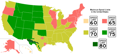
The highest speed limits are usually found in the inland West, and the lowest limits are usually found in the Northeast with the exception of Maine
, which raised its speed limit for a remote stretch of Interstate 95 through the northern part of the state to 75 mph in June 2011. Some limits fall outside these ranges. For example, some two-lane rural roads in Texas have 75 mph (121 km/h) speed limits, and there are two stretches of Interstate Highway in Texas with a daytime 80 mph (129 km/h) speed limit for passenger vehicles, as well as two stretches in Utah with 80 mph limits tested in 2009. In contrast, the highest speed limit on freeways in Hawaii is 60 mph (97 km/h). A statute effective June 17, 2011, authorizes 85-mph speed limits in Texas, although the new law requires traffic and engineering studies before the higher limit takes effect.
, on typical road
s in each category. The values shown are not necessarily the fastest or slowest. They usually indicate, but not always, statutory
speed limits. Some states and territories have lower truck speed limits applicable to heavy trucks
. If present, they are usually only on freeways or other high speed roadways.
{|class="wikitable" style="text-align:center"
!State or territory!!Freeway (rural)!!Freeway (trucks)!!Freeway (urban)!!Divided (rural)!!Undivided (rural)!!County (rural)!!Residential divided (urban)!!Residential undivided (urban)!!School zone
|-
|align="left"| Alabama
||colspan="2"|70||60||65||55||35–45||25||25||15
|-
|align="left"| Alaska
||colspan="2"|65||65||65||65||50||25||||20
|-
|align="left"| American Samoa
||–||–||–||–||25–30||–||||15||
|-
|align="left"| Arizona
||colspan="2"|75||65||65||65||65||25||||15
|-
|align="left"| Arkansas
||70||65||65||60–65||55||||||||
|-
|align="left"| California
||70||55||55-65||65||55–65||55–65||25||||25
|-
|align="left"| Colorado
||colspan="2"|65-75||55–65||65||65||35–55||25–35||||20–25
|-
|align="left"| Connecticut
||colspan="2"|65||45-55||55||55||45||25-40||||20
|-
|align="left"| Delaware
||colspan="2"|65||50-55||55||50||||25-35||||20
|-
|align="left"| District of Columbia||-||-||50||-||-||-||25||||15
|-
|align="left"| Florida
||colspan="2"|70||55-65||65||60||55-60||30||||10-20
|-
|align="left"|.svg.png) Georgia
Georgia
||colspan="2"|70||55-65||65||55||-||30||25-45||
|-
|align="left"| Guam
Guam
||-||-||-||35-45||35-45||-||||||
|-
|align="left"| Hawaii
||colspan="2"|55-60||50||45||45||45||||||
|-
|align="left"| Idaho
Idaho
||75||65||65||65||65||50-65||||||20
|-
|align="left"| Illinois
||colspan="2"|65||55-65||65||55||55||30||||20
|-
|align="left"| Indiana
||70||65||50-65||60||55||55||20-30||||20-25
|-
|align="left"| Iowa
Iowa
||colspan="2"|70||55-65||65||55||45||25||||25
|-
|align="left"| Kansas
||colspan="2"|75||65||65-70||65||55||30||||20
|-
|align="left"| Kentucky
||colspan="2"|70-75||50-55||55||55||55||25-35||||25-45
|-
|align="left"| Louisiana
||colspan="2"|70-75||60||65||55||45||10-30||10-30||20-45
|-
|align="left"| Maine
Maine
||colspan="2"|65-75||55||55||55||50||||||
|-
|align="left"| Maryland
||colspan="2"|65||55-65||55||50-55||||||||15-25
|-
|align="left"| Massachusetts
||colspan="2"|65||55||55||55||||30||||20
|-
|align="left"| Michigan
||70||60||55-70||55-65||55||55||25||||25
|-
|align="left"| Minnesota
||colspan="2"|70||45-60||55-65||55-60||55||30||||
|-
|align="left"| Mississippi
||colspan="2"|70||60-70||65||55||||25||||
|-
|align="left"| Missouri
||colspan="2"|70||45-65||55-70||55-65||55||25||||20
|-
!State or territory!!Freeway (rural)!!Freeway (trucks)!!Freeway (urban)!!Divided (rural)!!Undivided (rural)!!County (rural)!!Residential divided (urban)!!Residential undivided (urban)!!School zone
|-
|align="left"| Montana
||75||65||65||70||55-70||55-70||25||||15
|-
|align="left"| Nebraska
||colspan="2"|75||60||65||55-65||50-55||25||||25
|-
|align="left"| Nevada
||colspan="2"|75||60-65||65-70||55-70||55-70||25||||15, 25
|-
|align="left"| New Hampshire
||colspan="2"|65||55||55||55||35||30||||20
|-
|align="left"| New Jersey
||colspan="2"|65||55||55||45-55||30-50||25||||15-35
|-
|align="left"| New Mexico
||colspan="2"|75||65-75||65-70||55-65||25-55||25-30||||15-20
|-
|align="left"| New York
||colspan="2"|65||50-55||55||55||55||30||||
|-
|align="left"| North Carolina
||colspan="2"|70||60-65||55-60*||55||||20-35||20-35||20-35
|-
|align="left"| North Dakota
||colspan="2"|75||55-75||70||40-65||40-55||30-55||20-45||15-25
|-
|align="left"| Ohio
Ohio
||colspan="2"|65-70||55-65||55-65||55||55||25-35||||20
|-
|align="left"| Oklahoma
||colspan="2"|70-75||55-65||60-70||55-65||45||25||||25
|-
|align="left"| Oregon
||65†||55||50-60||55||55||55||25||||20
|-
|align="left"| Pennsylvania
||colspan="2"|65||55-65||55||55||35-45||25-35
||20-35||15
|-
|align="left"| Puerto Rico
||60-65||50-55||||||45-55||-||25-35||||15-25
|-
|align="left"| Rhode Island
||colspan="2"|65||55||55||50||-||25||||20
|-
|align="left"| South Carolina
||colspan="2"|70||60||60||55||-||30||||
|-
|align="left"| South Dakota
||colspan="2"|75||55-65||65-70||45-65||35-55||25-45||||15-25
|-
|align="left"| Tennessee
||colspan="2"|70||55-70||65-70||55||35-45||20-45||||15-20
|-
|align="left"| Texas
Texas
||colspan="2"|70-80||55-65||70-75||70-75||30-60||30||||15-55
|-
|align="left"| U.S. Virgin Islands
||-||-||-||55||35||-||20||||
|-
|align="left"| Utah
Utah
||colspan="2"|75-80||65||65||65||||25-35||||20
|-
|align="left"| Vermont
||colspan="2"|65||55||55||50||50||||||
|-
|align="left"| Virginia
||colspan="2"|65-70||55-65||55-60||55|| ||25||||15-35
|-
|align="left"| Washington||70||60||60||65||65||50-55||25-50||||20-25
|-
|align="left"| West Virginia
||colspan="2"|70||60-65||65||55||55|||25-55||||15 or 35
|-
|align="left"| Wisconsin
||colspan="2"|65||55-65||55-65||55-65||55||25-35||||15
|-
|align="left"| Wyoming
||colspan="2"|75||65||65||65||||||||
|}
† Oregon state law permits a maximum statewide speed limit of 70 mph, but gives the Oregon Department of Transportation discretion in selecting which roads to post at 70 mph. Currently ODOT has not identified any roadways whose speed limits should be raised to 70 mph. Thus, the highest posted speed limit seen in Oregon is 65 mph.
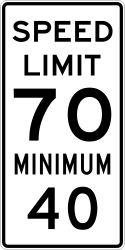 In addition to the legally defined maximum speed, minimum speed limits may be applicable. Occasionally there are default minimum speed limits for certain types of roads, generally freeways.
Comparable to the common basic speed rule, most jurisdictions also have laws prohibiting speeds so low they are dangerous or impede the normal and reasonable flow of traffic
.
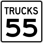 Some jurisdictions set lower speed limits that are applicable only to large commercial vehicles like heavy trucks
and buses. While they are called "truck speed limits", they generally do not apply to light truck
s.
, are far heavier than other vehicles, they take longer to stop, are less adept at avoiding hazards, and have much more momentum. Therefore, it follows from basic physics that limiting truck speeds could reduce the severity and incidence of truck-related crashes.
However, the research record is mixed. A 1987 study finds that crash involvement significantly increases when trucks drive much slower than passenger vehicles, suggesting that the difference in speed between passenger vehicles and slower trucks could cause crashes that otherwise may not happen. Furthermore, in a review of available research, the Transportation Research Board
(part of the United States National Research Council
) states "[no] conclusive evidence could be found to support or reject the use of differential speed limits for passenger cars and heavy trucks" (page 11) and "a strong case cannot be made on empirical grounds in support of or in opposition to differential speed limits" (page 109).
Two thirds (67%) of truck/passenger car crashes are the fault of the passenger vehicle.
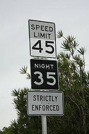 While the basic speed rule, which requires drivers to drive a reasonable and proper speed at all times, is usually relied upon to regulate proper night speed reductions, numeric night speed limits (which generally begin 30 minutes after sunset and end 30 minutes before sunrise, though this may vary by local law) generally may be established on roads where safety problems require a speed lower than what is self-selected by drivers.
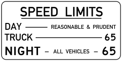
Montana also uses night speed limits statewide on federal, state and secondary roads. They were once used on interstates but only until 1999.
Night speed limits are indicated on some streets in Tucson, Arizona
without street lights.
Some roads in Florida have night speed limits near SW Florida Int'l Airport near Cape Coral / Fort Myers.
Colorado Highway 13 has a 65 day/55 night speed limit beginning 7.1 mi. north of I-70 from north of Rifle to CO. Hwy. 64 south of Meeker.
Rural CO. Hwy. 13 is 55 mph at night north of Meeker all the way to the Wyoming state line.
 Subjective or political influence on speed limits is evident by state-to-state speed limit variances that have no empirical justification, such as:
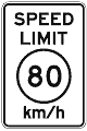 Though not common in the United States, a speed limit may be defined in kilometers per hour
(km/h) as well as miles per hour (mph). The Federal Highway Administration
's Manual on Uniform Traffic Control Devices
, which provides guidelines for speed limit signage, states that "speed limits shown shall be in multiples of 10 km/h or 5 mph." If a speed limit sign indicates km/h, the number is circumscribed and "km/h" is written below. Prior to 2003, metric speed limits were designated using the standard speed limit sign, usually with yellow supplemental "METRIC" and "km/h" plaques above it and below it, respectively.
The 1995 National Highway System Designation Act prohibited use of federal funds to finance new metric signage.
, Congress
enacted the National Maximum Speed Law
that created the universal 55 miles per hour (24.6 m/s) speed limit.
The law was widely disregarded by motorists, even after the national maximum was increased to 65 miles per hour (29.1 m/s) in 1987 on certain roads. In 1995, the law was repealed, returning the choice of speed limit to each state.
have speculated on reimposition of federal speed limit controls.
In 2006, then-Senator (now U.S. Secretary of State) Hillary Clinton publicly supported reimposition of the 55 mph speed limit in a speech to the New York Press Club.
On July 3, 2008, U.S. Senator
John Warner
, R-VA
, wrote a letter to Energy Secretary
Samuel Bodman asking to look into what speed limit would provide optimum gasoline efficiency given current technology. He said he wants to know if the administration might support efforts in Congress to require a lower speed limit. In that same month, a Rasmussen
poll of American voters found that 59% oppose reducing the speed limits in the United States to 55 mph
.
Speeds in excess of speed limits account for most speed-related traffic citations; generally, "driving too fast for conditions" tickets are issued only after an incident where the ticket issuer found tangible evidence of unreasonable speed, such as a crash
.
A criticism of the "exceeding speed limits" definition of speeding is twofold:
Variable speed limits offer some potential to reduce speed-related crashes. However, due to the high cost of implementation, they exist primarily on freeways. Furthermore, most speed-related crashes occur on local and collector roads.
. However, some states have prima facie
speed limits. This offers motorists a valid defense to a speeding charge if it can be proven that the speed was in fact reasonable and prudent.
A successful prima facie defense is rare. Not only does the burden of proof rest upon the accused, a successful defense may involve expert witnesses or other expenses well in excess of the cost of a ticket. Furthermore, because prima facie defenses must be presented in a court, such a defense is difficult for out of town motorists. Speed limits in Texas, Utah
, and Rhode Island
are prima facie. Some other states have a hybrid system: speed limits may be prima facie up to a certain speed or only on certain roads.
, trucks carrying hazardous materials
are not to exceed 55 mph. A speed limit of 30 mph in urban areas and 35 mph on unpaved rural roads is enforced. The speed limit for county paved roads is 45 mph. All other 2 lane roads are limited to 55 mph. The interstate limit is 70 mph while other 4 lane highways are limited to 65 mph.
are 15 mph in alleys, 20 mph in a business district, 25 mph in a residential district, and 55 mph on other roads.
is 65 mph, within those districts the default speed limit is 25 mph. The school zone speed limit is 15 mph. Exceeding these limits only in the best of driving conditions is considered prima facie evidence of speeding. Altered speed limits are not prima facie.
The maximum speed limit on Interstate Highways is 75 mph. This limit may be applied outside of "urbanized areas", where speeds of over 85 mph on any highway
is considered "excessive". Within "business or residential" districts, exceeding the speed limit by more than 20 mph is considered "excessive". Within "urbanized areas", 55 mph speed limit citations are given for "waste of a finite resource". This exception only applies within a 10 mph threshold. As long as the speed does not exceed 65 mph, the infraction is not recorded as a traffic violation
for the purposes of a point system. Nonetheless, exceeding these 55 mph limits, effective on some freeways in Phoenix, for example, is illegal.
Non-passenger vehicles in excess of thirteen tons, or "vehicles drawing a pole trailer" weighing more than 3 tons may not exceed 65 mph unless signs are posted that allow such a speed. Yet this does not differ from the default speed limit, and has the practical effect of requiring extra consideration for posting a standard speed limit sign in excess of 65 mph.
A non-numeric minimum speed limit is incorporated with the basic speed rule in Arizona, which also prohibits speeds higher than would be "reasonable and prudent".
Night speed limit signs are posted on some roads within Tucson
city limits that do not have street lights. Examples: Fort Lowell Road from Oracle Road to Country Club Road, 22nd Street from I-10 to Cherry Avenue.
's "Basic Speed Law", part of the California Vehicle Code
, defines the maximum speed at which a car may travel as a "reasonable and prudent" speed, given road conditions. The numerical limit set by Caltrans
engineer
s for speed limit signs, generally found on all non-controlled-access routes, is considered a presumptive maximum "reasonable and prudent" speed. Speed limits are typically set by monitoring traffic flow over a period of time and using the 85th percentile rule—the speed at which 85 percent of motorists travel at or below.
Many speed limit signs are identified as "maximum speed", usually when the limit is 55 mph (89 km/h) or more. When the National Maximum Speed Law
was enacted, California was forced to create a new legal signage category, "Maximum Speed", to indicate to drivers that the Basic Speed Law did not apply for speeds over the federally-mandated speed cap; rather, it would be a violation to exceed the fixed maximum speed indicated on the sign, regardless of whether the driver's speed could be considered "reasonable and prudent".
A driver can receive a traffic citation
for violating the Basic Speed Law even if their speed is below the "maximum speed limit" if road, weather, or traffic conditions make that speed unsafe. However, because the Basic Speed Law establishes prima facie limits, not absolute ones, they can also defend against a citation for speeding "by competent evidence
that the speed in excess of said limits did not constitute a violation of the basic speed law at the time, place and under the conditions then existing," per section 22351(b) of the California Vehicle Code. As attorney David W. Brown says in his book Fight Your Ticket & Win in California, "a person traveling over the speed limit–but less than the usual 65 mph maximum speed (55 mph for two-lane undivided highways)–isn't necessarily violating the law" and that "you can defend against a charge of violating the Basic Speed Law not only by showing you weren't exceeding the speed limit, but also by establishing that even if you were over the limit, your speed was nevertheless 'safe' under the circumstances."
Rural freeways, such as parts of I-5
, I-8, I-10
, I-15
, I-40
, and U.S. 101 on the central coast, and SR 99
south of Madera
and Fresno
, have 70 mph (113 km/h) speed limits. Because I-80
passes exclusively through urban and mountainous areas, its highest speed limit is only 65 mph. In downtown Los Angeles
, the maximum speed limit is 55 mph. This includes the entire length of the Pasadena Freeway
between Pasadena
and downtown Los Angeles, and portions of the Hollywood
, Santa Ana
, Santa Monica, and Harbor Freeways. The default limit on 2-lane roads is 55 mph. However, Caltrans or a local agency can post a speed of up to 65 mph after an engineering study
.
All of these highways feature supplementary signage stating "AUTOS WITH TRAILERS/TRUCKS 55 MAXIMUM". Maximum truck/autos with trailers limit applies to trucks with 3 or more axles and all vehicles when towing. As of 2007, these signs are being replaced with signage stating "ALL VEHICLES WHILE TOWING 55 MAXIMUM".
In California, the Maximum Speed in school zone
s is 25 mph, but is in effect only if children are present within that school zone.
are normally 65 MPH on rural freeways; up to 55 MPH on rural divided and undivided highways. In urban areas speed limits vary from 25 MPH on residential streets and central business district
s to 30-40 MPH on arterial roadways, and from 45 to 55 MPH on urban freeways. Limited-access divided highway
s have a minimum speed of 40 mph (64 km/h), but this is not always posted.
Speed limits for all roads within Connecticut—including local streets—are established by the State Traffic Commission, an agency composed of members of the Department of Motor Vehicles
(CTDMV), the Department of Public Safety
, and the Department of Transportation
(CONNDOT).
The State Traffic Commission typically sets speed limits following engineering studies performed by CONNDOT. Data used in setting speed limits includes: traffic volume vs. roadway capacity, design speed, road geometry, spacing of intersections and/or interchanges, number of driveways and curb cuts, and accident rates.
Municipalities are normally required to seek approval from the State Traffic Commission for changes to the posted speed limits on locally-owned streets after appropriate engineering studies are performed.
Speeding fines are doubled in school zones when children are present, and construction areas when workers are present.
Prior to 1974, Connecticut permitted a maximum speed of 70 MPH on rural freeways.
, only two roads have a 65 mph (105 km/h) speed limit: I-495
and Delaware Route 1. Interstate 95
is 55 mph (89 km/h) and Interstate 295 is 50 mph (80 km/h).
All rural two-lane state-owned roads have 50 mph (80 km/h) speed limits, while all urban speed limits, regardless of location, are held at 25 mph (40 km/h) for two-lane roads and up to 35 mph (56 km/h) for four-lane roads. Four lane highways such as US 13
and US 113
are normally 55 mph.
School zone
s have 20 mph (32 km/h) speed limits.
Interstate 495
, which forms a bypass around Wilmington
, features changeable speed limit signs for environmental purposes. These signs typically display a 65 mph speed limit, but this limit changes to 55 mph on days when air quality is a concern.
raised its speed limit from the federally mandated 55 mph national limit
(1974–1987) to 65 mph in 1987. In 1996, after the 1995 repeal of federal speed limit controls, Florida raised the speed limit to 70 mph on expressways
, including rural Interstate Highways, and limited access toll road
s; 65 mph on rural 4-lane highways (including US
and State highway
s); and 60 mph on rural 2-lane highways.
Florida is the only state east of the Mississippi River
where a speed limit greater than 55 is allowed on two-lane roads. 60 mph on two-lane roads is usually allowed on United States Highways, some state highways and rarely posted on some county roads.
Florida typically does not post night speed limits, but there are a few exceptions. For the most part, these night time reduced speeds are located in wildlife preserves for such endangered species
as the Florida panther
and the key deer
. Most of the Tamiami Trail
through the Big Cypress National Preserve
has a 45 mph night speed limit. On some stretches of road where the speed limit is reduced at night, the daytime speed limit sign is not reflective so at night, only the night limit is visible
.
County roads typically have 55 or 60 mph limits.
Florida's minimum speed limit on Interstate Highways is now 50 mph in most 70 mph zones, up from the previous 40 mph minimum. In 55 mph, and 65 mph urban interstate zones, the minimum remains 40 mph.
The State of Florida also does not impose a lower truck speed limit.
All interstate traffic is permitted to travel at the same speed.
School zone
s in Florida usually have 10 mph to 20 mph limits. Most have flashing yellow lights activated during the times they are in effect as well as accompanying signs which post the times these reduced speed limits are effective. All are strictly enforced and carry an increased penalty for violations.
Four lane arterials and expressways can be posted as high as 65 mph. However, Dillon's Rule
enables counties outside municipalities to keep four lane GRIP corridors at 55 mph. However in recent years, US 1 between Augusta and Wrens raised the speed limit to 65 mph.
Two lane state roads by default are posted at 55 mph. County maintained roads will rarely if they even do, post any roadway above 50 mph in middle & south Georgia, 45 mph in north Georgia. Both in the Atlanta area, Ronald Reagan Parkway is posted at 50 mph as a county maintained freeway and Sugarloaf Parkway is posted at 45 mph.
Inside the municipality, speed limits are generally posted at 35 mph while it is 25-30 mph in the downtown area.
All roadways maintained by GDOT that are subject to speed limit reductions are given advanced notice with signage that says "REDUCED SPEED AHEAD". Furthermore, GDOT has a policy of doing 5 to 10 mph increments but never higher than 10 mph.
Georgia is one of few state's with anti-speed trap laws passed in the late 1990s. Speed violations less than 15 mph over the speed limit will have no points assessed. Fines are not assessed for motorists going less than 5 mph over the speed limit.
was the last state to raise its maximum speed limit after the National Maximum Speed Law
was repealed in 1995. In 2002, after public outcry after a controversial experiment with speed enforcement using road safety cameras, the state Department of Transportation raised the speed limit to 60 mph on Interstate H-1
between Kapolei
and Waipahu, and Interstate H-3
between the Tetsuo Harano Tunnels
and the junction with H-1. All other freeways, including Interstate H-2
, have a maximum speed limit of 55 mph, with the limit dropping to 45 mph in central Honolulu. Other highways generally have speed limits of 55 mph and in many cases much less.
Hawaii has a minimum speed along much of Interstate H-1
of only 10 mph below the speed limit. The minimum speed is usually 45 mph when the speed limit is 55, and 40 mph when the speed limit is 50.
are usually posted with both minimum and maximum speed limits, except in some urban areas, particularly Chicago
. Most expressways in Cook
, DuPage
, and Lake
counties, and some expressways in Will County
maintain a 55 mph speed limit. Due to the high population density, the only expressways in Cook County that exceed a speed limit of 55 mph are I-57
at the southern edge of the county and part of I-80
between Central Ave. and Harlem Ave. In downtown Chicago, where all the major expressways merge together, the speed limit is reduced to 45 mph due to high-traffic density and frequent entering/exiting of the expressways. All other expressway areas in Illinois maintain a 65 mph speed limit, except in areas approaching a major city where the speed limit may be reduced to 50 or 55. A construction zone almost always has a light posted to the speed limit sign that, when flashing, indicates to the driver that the construction speed limit must be obeyed. When the light is not flashing, drivers may obey the regular speed limit. Illinois brought Senate Bill SB3668 to the floor for discussion. This bill if passed by both houses and signed by the governor will raise Illinois rural interstate speed limits to 70 mph. This will exclude the 6 county region around Chicago.
The former "55" mph truck speed limit has been removed with the exception of Cook, DuPage, Lake, Kane, Will, and McHenry counties.
speed limits on Interstate Highways are usually 70 mph (113 km/h) for cars and 65 mph (105 km/h) for trucks with a gross vehicular weight (GVW) of 13 tons
or greater, except in urban areas, where it is generally 55 mph (89 km/h) in city centers (except stretches of I-70
in Indianapolis
where it is 50 mph) and 65 mph (105 km/h) cars/60 mph (95 km/h) trucks in suburban areas. The 65/truck: 60 signs are posted only for a short distance on freeways within Marion County
in the Indianapolis area. Prior to July 5, 2005, all Interstate Highways were 65 mph and below.
Most non-Interstate Highways are 55 mph, but some rural four-lane divided highway
s (such as rural stretches of U.S. 31, U.S. 40
and U.S. 41
, among others) are set at 60 mph. These limits often decrease to 30-50 mph (48–79 km/h) approaching urban areas, and within cities a speed limit of 20–30 mph (32–48 km/h) is not uncommon, though larger arterial road
s within cities may reach as high as 45 mph (72 km/h).
's rural Interstate's speed limits are typically 70 mph (113 km/h), with no distinction made for trucks. Urban Interstate speed limits are usually set at 65 mph (105 km/h), with 55 mph speed limits set within cities, such as Interstate 235
in Des Moines
. The Iowa DOT just recently increased the suburban speed limit on Interstate 235 to 60 mph, with 55 mph still effective for the downtown Des Moines area; 60 mph speed limits also exist on IA 58 and US 218 in Cedar Falls
/Waterloo
and on Interstate 380
outside of downtown Cedar Rapids
.
Non-Interstate divided highway
s are signed at 65 mph with speeds dropping to 55 mph in urban areas. Two lane rural state
and county highway
s have a 55 mph speed limit. The Interstate 74 bridge from Davenport
to Moline, Illinois
, has a 50 mph limit; the bridge is much narrower than normal and shoulderless.
Rural Interstates have a minimum speed limit of 40 mph, and U.S. Highway 20
between Interstate 35
and Dubuque
also has a 40 mph minimum speed, alongside a 65 mph maximum. Other four-lane divided rural highways are signed at 65 mph, with no minimum speed (with the purpose of allowing slow-moving farm vehicles to use the road as well).
raised its general interstate speed limit to 70 mile per hour; a study found "no statistically significant increases in crash, fatal crash and fatality rates were noted during the after period on either rural or urban interstate highway networks. On the other hand, statistically significant increases in crash, fatal crash and fatality rates were observed on the 2-lane rural highway network.". In 2011 Governor Sam Brownback
signed legislation raising Kansas' top speed limit to 75 mile per hour on divided four-lane highways, effective July 1, 2011. The Kansas Department of Transportation
announced on June 21, 2011, that 807 miles of roadway, comprising the rural areas of I-70, I-35, I-135, the Kansas Turnpike
and the freeway-improved sections of US-69 and US-81, will be raised to 75 mph. Prior to the National Maximum Speed Limit, the speed limit on the Kansas Turnpike was 80 mile per hour, but reduced to 75 mph on August 17, 1970.
The 75-mph speed limit on most of Interstate 70 matches that of neighboring Colorado. However, motorists driving into Oklahoma on Interstate 35 must drop their speed from 75 to 70, since Oklahoma's 75-mph limit applies only to turnpikes.
raised its rural freeway speed limits from 65 to 70 mph. Kentucky does still have limits of 55 on multi-lane highways in some urban areas (I-71/75 near Cincinnati, I-64
, I-65
, I-71
and I-264
in Louisville
, and the U.S. 60
bypass in Owensboro
). There are two 50 mph areas in Louisville. One approaching the Sherman Minton Bridge
crossing the Ohio River
into Indiana
on I-64, and one approaching the Kennedy Bridge
on I-65 towards Indiana
. Points are not assessed for speeds less than 10mph over the speed limit.
, 12, 20
, 49, 55
, 59, 220
, and 310.
A speed limit of 60 mph is posted on I-10 in Lake Charles
, Baton Rouge
, and from LaPlace
to New Orleans, I-12 in Baton Rouge, I-20 in Shreveport
and Monroe
, I-49 in Alexandria
and Shreveport, I-310 in Destrehan
, I-220 in Shreveport, U.S. Routes 71
and 167
in Kingsville, LA 3132, and Interstates 110
, 210
, 510, 610
, and 910.
In August 2003, Governor Mike Foster
announced speed and lane restrictions on trucks on the 18 mile (29 km) stretch of Interstate 10
known as the Atchafalaya Swamp Freeway. The restrictions lower the truck speed limit to 55 mph and restrict them to the right lane for the entire length of the elevated freeway.
Divided highways in rural areas have a 65 mph speed limits. Louisiana law R.S. 32:61(B) & 32:62(A) states;
Louisiana operates under the reasonable and prudent basic law;
A person, who is operating a motor vehicle on a multilane highway at less than the normal speed of traffic, shall drive in the right-hand lane then available for traffic. R.S. 32:71(B)(1)
(DOTD) raised the speed limit to 75 mph on a nearly 200-mile stretch of I-49 in Saint Landry, Avoyelles, Evangeline, Rapides, Natchitoches, and DeSoto parishes. The increase to 75 mph was authorized by a 2010 bill which allows DOTD to raise speed limits when the increase is shown by engineering and traffic studies to be safe.
/Maine Turnpike and 295
are 65 mph, except for a small 55 mph zone near the New Hampshire
border, a 55-mph zone on 95 in Portland vicinity and in Bangor
, and 50-55 mph zones on 295 in Portland
. The Saco
stub I-195
is 55 mph, and 395 is 55 mph in Bangor
and 60 mph in Brewer
. A bill to raise the speed limit between Old Town and Houlton from 65 to 75 mph unanimously passed in both chambers of the State Legislature and was sent to Governor Paul LePage
for his signature on June 28, 2011. Governor LePage signed it on June 29. The 75 mph speed limit went into effect September 27, 2011 (ninety days after the end of the Legislative session), when Maine became the first state east of the Mississippi River since the 1970s and the first state in the New England Region to establish a 75 mph speed limit.
's Interstate Highways are posted by default at 65 mph. Maryland's urban freeways normally have speed limits of 55 mph or 60 mph, although some stretches are signed for 65 mph travel such as portions of I-95
and I-97
in and around the Baltimore
suburbs. More restrictive limits are found on Interstate 83 south of North Avenue when approaching the downtown area
and on Interstate 68
through Cumberland
, both sections being marked for 40 mph.
Four lane non-interstates and non-freeways are posted at 55 mph. This includes the expressway grade roadways like US 50 and US 301 east of the Bay Bridge, US 15 north of Frederick to the PA state line, MD 404 around Denton and US 29 between I-495 and I-70.
Two lane roads are generally posted at 50 mph but there are a handful of routes posted at 55 mph. It's more common to see 55 mph on the Eastern Shore
than the Baltimore-Washington corridor and Appalachia.
Urban & downtown speed limits are generally posted at 30 mph.
are usually signed with both minimum and maximum speeds. Typically the freeway speed limit is 70 mph. The minimum speed is usually 45 to 55 mph for all vehicles, despite a maximum speed limit of 60 mph (55 mph on non freeway roads that have a posted speed limit at 65 for cars) for trucks—effectively permitting trucks only a 5 mph range of legal speeds.
's Interstate
s outside of urban areas. A speed limit of 55 mph is typically used in urban areas where a higher speed limit might be used, but traffic congestion or other reasons require a lower speed limit. Examples include I-94
, I-35W
and I-35E
in and around Minneapolis, Moorhead
and Saint Paul
. 35E goes down to a speed limit of 45 mph in some areas of Saint Paul. A speed limit of 60 mph is typically used in suburban areas such as I-494
and I-694
loops in the Twin Cities metro area.
Non-Interstate divided highway
s (both freeways and rural expressways
) such as sections of US-169
, US-212
, the divided sections of US-2
and most of US-10
have speed limits of 65 mph in rural areas and up to 55 mph in urban or suburban areas. Undivided sections have speed limits of 55 mph while most of US-71
and the undivided section of US-2 have a limit of 60 mph. County roads have speed limits of up to 55 mph for 2 lanes and 60 for divided sections.
's rural freeways; only the Interstates (except I-110
), U.S. Highway 78, Mississippi Highway 304, and a portion of U.S. Highway 82 have speed limits of 70 mph, with these lengths making up approximately 86% of the state's freeway mileage.
A speed limit of 65 mph is typically used on the state's four lane divided highways, which include parts of the following roadways:
A speed limit of 60 mph is typically used in urban areas where a higher speed limit might be used, but traffic or geometric conditions constitute a lower speed limit, including the following areas:
House Bill 3, passed during the 2008 First Extraordinary Session of the state legislature, permits speed limits up to 80 mph (128.7 km/h) on toll roads in the state; however, , no such road has been constructed.
Mississippi has a minimum speed of 30 mph on four-lane U.S. highway
s when no hazard exists. Strangely, there is no law for the minimum speed of the state's growing number of four-lane state highways. The minimum is 40 mph on Interstate Highways and on four-lane U.S. designated highways which have a 70 mph speed limit. In 2004, Mississippi posted minimum speed limits (40 mph) on all rural Interstates, but this minimum speed limit was already state law before then.
recently began a two-year experiment with variable speed limits along I-270
around St. Louis
. Digital sign
s have been erected along the freeway as well as additional signs alerting drivers about the use of variable speed limits. The limits will vary between 40 and 60 miles per hour, depending on traffic conditions, and could change by up to 5 mph every 5 minutes.
Interstate freeways in Missouri generally have a maximum speed limit of 70 MPH in rural areas and 60 MPH in more populated areas. During the closure and major rebuild of I-64
(aka US-40
) in St. Louis, an additional lane was added to I-44
and I-70
, and the speed limit was thus reduced to 55MPH on those roads within the St. Louis County and City. Though I-64 (US-40) construction has been completed, the extra lanes will not be removed until spring through fall of 2010, and therefore the speed limit will remain 55 MPH on I-70/I-44. Freeways have minimum speed limits of 40 mph.
Most two-lane roads have a 60 mph speed limit in Missouri. However US-54
west of El Dorado Springs
has a 65 mph speed limit in Vernon County. A speed limit of 65 mph is also along Highway 67 between Bonne Terre and Festus.
had a non-numeric "reasonable and prudent" speed limit during the daytime on most rural roads. Montana Code Annotated (MCA) Section 61-8-303 said "A person . . . shall drive the vehicle . . . at a rate of speed no greater than is reasonable and proper under the conditions existing at the point of operation . . . so as not to unduly or unreasonably endanger the life, limb, property, or other rights of a person entitled to the use of the street or highway."
 Montana law also specified a few numeric limits: a night speed limit, usually 55 or 65 mph (89–105 km/h), depending on road type; 25 mph (40 km/h) in urban districts and 35 mph (56 km/h) in construction zones.
The phrase "reasonable and prudent" is found in the language of most state speed laws. This allows prosecution under non-ideal conditions such as rain or snow when the speed limit would be imprudently fast.
issued a speeding ticket
to a driver traveling at 85 mph (136 km/h) on a stretch of State Highway 200
. The 50 year-old driver (Rudy Stanko) was operating a 1996 Camaro with less than 10,000 miles (16,093 km) on the odometer
. Although the officer gave no opinion as to what would have been a reasonable speed, the driver was convicted. The driver appealed to the Montana Supreme Court
. The Court reversed the conviction in case No. 97-486 on December 23, 1998; it held that a law requiring drivers to drive at a non-numerical "reasonable and proper" speed "is so vague
that it violates the Due Process
Clause ... of the Montana Constitution
".
Effective May 28, 1999, as a result of that decision, the Montana Legislature
established a speed limit of 75 mph.
, did not convene an emergency session of the legislature. Montana technically had no speed limit whatsoever until June 1999, after the Montana legislature met in regular session and enacted a new law. The law's practical effect was to require numeric speed limits on all roads and disallow any speed limit higher than 75 mph (121 km/h).
Montana law still contains a section that says "a person shall operate a vehicle in a careful and prudent manner and at a reduced rate of speed no greater than is reasonable and prudent under the conditions existing at the point of operation, taking into account the amount and character of traffic
, visibility
, weather
, and road
way conditions." However, this is a standard clause that appears in other state traffic codes and has the practical effect of requiring a speed lower than the speed limit where a lower speed is necessary to maintain a reasonable and prudent road manner.
Montana also has limited sections of night speed limits.
is 70*-75 mph on rural freeways, 65-75 mph on other rural divided highways, 55-70 mph on primary two-lane roads, and 65 mph on urban freeways.
is 65 mph (105 km/h). It can be found on Interstate Highways and the Everett Turnpike
. The minimum speed on Interstate Highways in New Hampshire is 45 mph where posted.
Provided that no hazard exists that requires lower speed, the speed of any vehicle not in excess of the limit is deemed to be prima facie lawful. The limit for "rural residential districts" and Class V highways outside the city or town compact is 35 mph. The limit for any "business or urban residence district" is 30 mph. School zone
s receive a 10 mph reduction in the limit 45 minutes before and after the beginning and end of a school day. The speed limit for a road work or construction area is 10 mph lower than the normal speed limit, but not more than 45 mph, when work is in progress. The speed limit for all other locations is 55 mph. The minimum limit that a speed can be set in a rural or urban district is 25 mph.
The speed limit on Interstate 93
through Franconia Notch State Park
falls to 45 mph when the highway narrows to one lane in each direction, but rises back to 65 mph (in 10 mph increments going south) once the highway leaves Franconia Notch. Interstate 393
in Concord
has a 55 mph posted speed limit for its entire length, with the exception of 45 mph and 35 mph zones on the westbound portion closest to the city center and the end of the highway. The Interstate 293
speed limit through downtown Manchester
falls to 50 mph as it runs along the Merrimack River
, but increases to 55 mph on either side of the city center.
Prior to 1974, the New Hampshire Turnpike
, along with rural sections of Interstate 89
and 93
, were posted at 70 mph.
The common limited access freeway speed limit is 65 mph. However, shorter length freeways such as US 202, NJ 15 and NJ 33 remain at 55 mph. In all 65 mph speed zones, the speeding fines and "other violations" are doubled. This was the condition set for higher speed limits in New Jersey back in the late 1990s. Urban freeway speed limits are 50 to 55 mph. However, some freeways in urban areas retain a 65 mph speed limit such as the New Jersey Turnpike up to Exit 13, Interstate 278, I-80 from the Delaware Water Gap to the Passaic River and I-78 from the Delaware River to the Newark border. Only the New Jersey Turnpike has variable speed limits on its entire length.
Four lane or greater divided state highways (with a jersey divider or grass median) are generally posted at 55 mph. County four lane highways and municipal maintained four lane roads (with a jersey divider or grass median) are never posted above 50 mph.
Two-lane rural state highways and county maintained roads generally have 40 to 50 mph limits. The only two lane roads posted at 55 mph in New Jersey are County Route 539
, NJ 70 and NJ 72 in the Pine Barrens
of Ocean
and Burlington
counties. Also, NJ 54 has a 55 mph speed limit in Atlantic County
. The NJ 33 Freehold Bypass section where it is a super two is also 55 mph.
Urban two lane roads in boroughs and cities are 25 or 30 mph. Residential streets at the municipal or county level are generally posted at 25 mph speed limits in boroughs and cities. However, they can be as high as 35 to 40 mph at the county level, less likely in municipal maintained roads. Municipal and county maintained roads through Townships are a bit more common with speed limits higher than 25 mph through residential areas. Generally, anything above 40 mph becomes uncommon. However, there are a handful of 45 mph residential stretches such as Terill Road in Scotch Plains and at 50 mph, County Route 537 in Freehold Township (south of NJ 18).
School zones through urban and suburban areas on two lane roadways are normally posted with one sign and often without prior warning. Also, it is not unusual to see "25mph when children are present" signs regardless of the road's default speed limit (Example would be going from 45 mph to 25 mph).
had no default numeric speed limit until the early 1950s. Prior to the national 55 mph limit in 1974, the speed limit on rural Interstates was 75 miles per hour during the day and 70 mph at night. Primary highway
s in open areas had daytime speed limits of 70 mph and nighttime ones of 60 mph. Secondary highways in open areas had daytime speed limits of 60 mph and nighttime ones of 50 mph. Before the end of federal speed controls, the maximum speed limit was 65 mph on Interstate routes and 55 mph elsewhere. In May 1996 legislation enacted by Governor Gary Johnson
raised the absolute speed limit in New Mexico to 75 mph. Signs are posted on the vast majority of the mileage of Interstate routes to that effect.
New Mexico has six major freeway facilities which include three lengthy Interstate routes. Part of US-70
(as both a freeway and then a divided highway
) between Las Cruces
and Alamogordo
is the only section of non-Interstate route to have the 75 mph limit. There is no statutory requirement for reduced speeds on urban freeways so that, for example at Santa Fe
and Las Vegas
the speed limit remains 75 mph on I-25
. Nonetheless, there are 65 mph limits on freeways in more heavily urbanized areas such as Albuquerque
and Las Cruces. Other reduced speed limits do exist, but the lowest speed limit under normal conditions on New Mexico's freeways is 55 mph.
By statute, other state maintained roads may have speed limits of up to 75 mph. [87] Four-lane divided highways in open areas often have 65 mph limits, with some 70 mph limits, such as almost the entire length of US 550
from Bloomfield
to Bernalillo
. There is a trend toward posting a 70 mph limit on these highways, such as the recent 70 mph speed limit posting (increased from 65 mph) on a 23 mile stretch of U.S. 70
west of Roswell
.
Primary two-lane highways in open areas with parking shoulders often have 65 mph limits.
Most primary two-lane highways without parking shoulders in open and mixed rural areas still have a 55 mph limit, but some have 60 mph limits.
A 65 mph left lane minimum speed limit is sometimes indicated on 75 mph roads with steep grades, "slower traffic keep right" is also in effect. On one-way roadways state law reserves the left and center lanes of two or more lanes for passing. There are reduced advisory speed limits for some roads during poor weather. Speeding fines are doubled in construction zones and designated safety corridors, with signs often stating this. There are no longer night speed limits, nor are there any differential speed limits for heavy trucks.
There are two other statutory speed limits in New Mexico which are often altered, especially on urban arterial
s or even city or countywide: thirty miles per hour in a "business or residence district" and fifteen miles per hour near schools at certain times
. For example, in Albuquerque
the default speed limit is thirty miles per hour as per state law, but many street
s have a different speed limit. Some school zones there have twenty mile per hour speed limits. The city of Santa Fe's
default speed limit is twenty five miles per hour. Although there are no signs to make drivers aware of the altered limit, the limit is signed on most roads where it applies. Los Alamos County
alters the urban default and absolute speed limits to twenty five miles per hour and 50 mph respectively, but posts signs at county lines.
Outside of Bernalillo County
, no points are assessed to one's license for speeding in rural areas in New Mexico, unless the excessive speed was a contributing factor to a traffic accident.
 New York has a blanket statutory "Reasonable and Prudent" speed law. While it was mentioned at the beginning of this page that motorists may be able to use laws of this type as a legal defense, in New York it is frequently used to the advantage of law enforcement, who will (and do) not hesitate to issue tickets for, say, driving 45 in a 55 mph zone if road conditions do not, in their opinion, permit safe travel at that rate.
The highest posted speed limit in New York
is 65 mph (105 km/h), which is found on most of the New York State Thruway
and other rural Interstate Highways
. The State Speed Limit (a blanket or default speed limit for rural roads) is 55 mph (89 km/h), which is also the highest a non-expressway
or parkway
highway may have. Many 55 mph signs in New York thus read "State Speed Limit". The theme is followed, and many signs read "Area Speed Limit", "Town Speed Limit", "City Speed Limit" or "Village Speed Limit" with varying speeds shown below. In New York State, the default speed limit on any road not marked with a speed limit sign is 55 mph (unless local restrictions are stricter). New York City
and some other urbanized areas have a default speed limit of 30 mph (48 km/h) except where otherwise posted. The highest speed limit on expressways and parkway
s in New York City is 50 mph (80 km/h), with many freeways having a lower speed limit (such as the FDR Drive
with its 40 mph limit) that may vary based on a section of road (like sections of the Brooklyn-Queens Expressway
, having only a 35 mph speed limit).
Governor George Pataki
signed legislation in September 2003 that enables NYSDOT
and NYSTA
to raise speed limits to 65 mph on its roads that meet established design and safety standards. This legislation became active in March 2004, and has been used on over 100 miles worth of highway. An example of this is a 3-mile section of NY Route 7
(locally known as "Alternate Route 7") which connects Exit 7 of Interstate 87
(the Adirondack Northway) with Interstate 787
, the main highway into the city of Albany
. Prior to the new law, consent of the state legislature was necessary to enact a 65 mph speed limit, a process that could take months or years. In fact, New York was one of the last states in the United States to enable speed limits above 55 mph on any roads.
A minimum speed limit of 40 mph has been set on the entire length of Interstate 787
and the entire length of the Long Island Expressway. The New York State Thruway
does not have a firm minimum speed, but there are signs advising drivers to use their flashers when traveling at speeds below 40 mph.
While New York does not have truck speed restrictions per se, the New England Thruway (Interstate 95
) features "State Speed Limit 55" signs right next to "Truck Speed Limit 50" signs.
Up until about the 1980s, it was not uncommon to see the somewhat cryptic phrases "End 30 Mile Speed" or "End Speed Zone" when exiting a speed zone (e.g. city, village or hamlet) on a rural road; by the 1990s, most of those signs were replaced by the more clear "End 30 m.p.h. Limit." On state highways, however, new speed limit signs reading "State Speed Limit 55" are the standard indication of leaving a speed zone.
Excepting school zones, the lowest speed limit that can be set by cities, towns, or villages is 25 mph.
New York's Criminal Procedure Law prevents law enforcement personnel from issuing a tickets for any offense that they did not witness personally, meaning that, among other ramifications, the state's electronic toll collection system can not be used for speed enforcement.
, the statutory speed limit is 55 mph unless otherwise posted. Inside the municipal limits, the statutory speed limit is 35 mph unless otherwise posted. The downtown statutory speed limit is 20 mph unless otherwise posted. "Reduce Speed Ahead" (RSA) signage is the norm
whenever the speed limit drops at any level. Note that the NC DOT uses the imperative verb "reduce" instead of the adjectival form "reduced" that is standard in other states, although some municipalities now use "reduced" in their signs. In addition, a speed limit drop of 15 mph or greater normally includes a second warning sign after the RSA. For example in a 55 mph zone, prior to the RSA sign would say "BEGIN 35 1000 FEET AHEAD" and then the 35 mph posted speed limit. Three to eight lane boulevards
with or without center turn lanes, range from 35 mph to 50 mph within municipal limits statewide.
School zone
speed limits are generally entail a 10 to 20 mph reduction below the original speed limit during open school hours of arrivals and departures. Such a speed limit would be indicated when entering the school zone. Also, the default or modified speed limit is indicated after leaving the school zone. A school zone speed limit cannot be less than 20 mph.
Military base
s are generally posted at the maximum of 50 mph. As of May 2010, Fort Bragg
military two-lane roadways are now posted at 55 mph instead of 50 mph. Prior to May 2010, the speed limits higher than 50 mph through military bases were only on N.C. Highway 690 along the north side of Fort Bragg, Bragg Boulevard (also known as N.C. Highway 24) and the All American Freeway (a state secondary maintained freeway).
The state park speed limit is 25 mph unless otherwise posted. These are not limited to places like Hanging Rock State Park
and Mount Mitchell State Park
.
The Blue Ridge Parkway
is 45 mph. However, there are occasional 35 mph stretches. The National Park Service
is responsible for highway maintenance and speed enforcement.
The county governments of North Carolina
do not have any control over speed limits or any other aspect of road operation, as there are no county roads in the state. Municipalities, on the other hand, can set speed limits on city-controlled roadways, subject to applicable state laws.
Freeways and expressways with no primary route number are under the state secondary road system where their route numbers are 1000 or greater. The speed limits are posted at the maximum of 55 mph.
A speed limit of 70 mph is relatively uncommon in much of metropolitan North Carolina, though it applies to many rural interstate highways in the state, as well as several non-interstate freeways. The following are the only roads with 70 mph limits:
These lengths make up approximately 568 miles, or 27%, of the total freeway mileage in North Carolina (384 miles or 31% of the state's growing Interstate system). Four-lane freeway-grade highways are generally posted at 65 mph through the state of North Carolina.
Freeways with 60 mph speed limits are found along I-40 between Asheville
and Waynesville
and through Greensboro
; on I-85 in Gaston
and Mecklenburg
counties and through Durham
; on I-440 along the northern half of Raleigh
's Beltline; on I-26
between Asheville and Hendersonville
; and on the US-311
High Point
Bypass, US-74 Laurinburg
bypass, US-23 Waynesville
Bypass, and US-401
Fayetteville
bypass.
60 mph speed limits along non-freeway segments are growing in popularity into replacing 55 mph boulevard and expressway
segments throughout the state. The boulevard speed limit changes go against the NCDOT rationale behind signing 60 mph speed limits along only freeway and expressway segments. As of June 1, 2008, some examples of the affected boulevards are US 17
north of Elizabeth City
, US 74
east of Wadesboro
and NC 11 in Pitt County
. Some examples of the affected expressways are US 1
in northeastern Moore County
, US 17
on bypass routes in Brunswick County
, US 74
east of I-95
, US 117
in Wayne County
and US 220
in Rockingham County
only along bypass segments. Previously, the entire US 220 alignment from NC 68
to the Virginia
state line was 60 mph but went back to 55 mph between NC 68 and NC 704.
There is a default minimum speed limit on Interstate and primary highway
s only when sign
s are present. The minimum is 40 mph if the maximum is 55 mph. The minimum is 45 mph if the maximum is at least 60 mph. These minimums do not apply to vehicles that are towing other vehicles.
is 75 mph, which can be found on Interstates 29 and 94
. Urban speed limits are as follows: Fargo
: 55 mph, Bismarck
/Mandan
60 mph on I-94
in North Dakota and Bismarck Expressway is at 40-55 MPH, Grand Forks
, Valley City
, Jamestown
, and Dickinson
remain at 75 mph. Rural four-lane divided
or undivided highway are 70 mph. Rural 2-Lane US numbered, and State Highway
s have 65 mph limits. Divided US numbered, and State Highways that pass through cities have 25–55 mph limits. undivided US numbered, and State Highways that pass through cities have 25–50 mph limits. 65 mph speed limits on county roads can be found in certain counties. Certain major county roads have 50–55 mph statutory limits for cars and 30–55 mph for trucks. A default 55 mph speed limit applies on other county roads. Speed limits on surface streets range from 30 to 40 mph. Residential streets are generally 10–25 mph. School zones are 15–25 mph. It is to uncommon see residential and business districts above 50 MPH.
s in Ohio
is 70 miles per hour (31.3 m/s) on the Ohio Turnpike, 65 miles per hour (29.1 m/s) on Interstates, and a split speed limit of 65 miles per hour (29.1 m/s) for cars and 55 miles per hour (24.6 m/s) for trucks remains in effect on non-Interstate freeways. No non-divided highway in the state has a speed limit higher than 55 miles per hour (24.6 m/s). Historically, Ohio had speed limits of 70 mph (113 km/h) except on the Ohio Turnpike
, which had speed limits up to 75 miles per hour (33.5 m/s) prior to 1974.
Although Ohio does not have a separate urban and rural speed limit on Interstates by state law, many urban areas have lower speed limits due to safety concerns found in speed studies. These commonly are in the 50-60 mph range. For instance, in most of metro Dayton
and Cincinnati, as well as in downtown Columbus
, the speed limit is 55 miles per hour (24.6 m/s), while in Cleveland
, Toledo
, and Akron
the speed limit is 60 miles per hour (26.8 m/s); however, in central Cleveland along the Inner Belt the speed limit is 50 miles per hour (22.4 m/s). Some urban areas are also posted with minimum speed limits, usually with a minimum of 40 or 45. At one time, portions of Interstate 76
and interstate 77
in downtown Akron
had a maximum speed limit of 50 mph and a minimum speed limit of 35 mph.
As of July 1, 2009, trucks can travel at 65 miles per hour (29.1 m/s) on Interstate highways where cars are permitted to travel at 65 miles per hour (29.1 m/s), but not on freeways which are not Interstates. Previously, only trucks travelling the Ohio Turnpike
were permitted to travel 65 mph. The speed limit on all other roads was, at most, 55 miles per hour (24.6 m/s) and will continue to be so on non-Interstate highways. On Interstate highways where cars have a speed limit of 55 miles per hour (24.6 m/s) or 60 miles per hour (26.8 m/s), trucks remain limited to 55 miles per hour (24.6 m/s). Unlike other states where the term truck usually only means vehicles requiring a Commercial Driver's License
to operate, Ohio considers most vehicles with an empty weight of 8000 lbs or more to be a truck for the purposes of the truck speed limit.
A bill has been introduced in the State senate that would restore rural freeway speed limits back to 70 mph.
On December 20, 2010, the Ohio Turnpike Commission voted to increase the speed limit of the Ohio Turnpike
to 70 miles per hour (31.3 m/s). Despite opposition from the Ohio Trucking Association and the Ohio Motorists Association, the increase was approved by the Commission by a vote of 4 to 1 and went into effect on April 1, 2011.
, the maximum speed limit is 75 miles per hour on turnpike
s and 70 mph on all other freeways. Most other rural highways have a 65 mph speed limit (although some rural divided highway
s have a 70 mph limit). Minimum speed limits that are 25 mph below the maximum speed limit on more or less all Interstate Highways. For example, on the turnpikes, which have a maximum speed limit of 75 mph, they are nearly always accompanied by a sign
stating a minimum speed limit of 50 mph.
Where turnpikes are signed with a speed limit of 75 miles per hour, a sign warning "no tolerance" is posted, warning drivers that state troopers will write tickets for speeding for ANY violation of this higher limit.
 The highest posted speed limit in Oregon is 65 mph on rural freeways. While Oregon state statutes allow for a maximum speed limit of 70 mph on rural interstate highways, the law gives the Oregon Department of Transportation (ODOT) discretion to define which freeway segments to post the 70 mph speed limit. Currently, ODOT has not identified any freeway sections that it believes should be raised beyond the maximum posted speed limit of 65 mph. In all rural areas in Oregon, the speed limit is 55 in less otherwise posted.
Up until 2002, Oregon
state law required that all speed limit signs omit the word limit from their display. The reasoning behind this was related to the explicit "basic speed" law that existed, which allowed citation for exceeding speeds "too fast for conditions" regardless of the posted speed. The spacing between and appearance of the numbers on the signs vary greatly depending on which jurisdiction made the sign. In 2002, the Oregon Department of Transportation
required the inclusion of the word "limit" on speed signs on Interstate
highways (though the older "Speed" signs are still up in many locations), and left it up to local government agencies to decide on whether "limit"-branded signs would be installed on other roads. Most have chosen not to change over with a few exceptions to the rule. Speed Limit 60 signs can be found on Interstate 5
through Salem
, on Interstate 84
through east Portland
, 55 signs can be found on Interstate 205
, and some new 50 signs are found on Interstate 405
. The city of Beaverton
has been the most liberal in retrofitting the standard-form Speed Limit sign, Whenever a "Speed" sign is damaged or vandalized in Beaverton city limits, a "Speed Limit" sign takes its place.
Throughout the late 1990s the Oregon state legislature passed multiple bills that would have raised the speed limit to 75 miles per hour on rural Interstate Highways and up to 70 mph on certain rural two lane highways in the eastern portions of the state. Each year Governor
John Kitzhaber
vetoed the bill despite widespread public approval. In 2003, the Oregon state legislature passed a bill that would have raised the maximum permissible speed limit on Interstate Highways to 70 mph for cars with a 5 mph differential for trucks, up from the previous 65 mph limit for cars with a 10 mph differential; this bill was signed into law by then newly-elected Governor Ted Kulongoski
. In 2004 the Oregon Department of Transportation decided to not implement the increase out of concerns that it would not be safe to have trucks traveling at 65 mph. Prior to the National Maximum Speed Law
, the speed limit on Oregon interstates could be as high as 75 mph. Oregon
remains the only state in the contiguous United States west of the Mississippi River
to have a maximum state speed limit that is under 70 mph.
In 2004, a law was passed revising Oregon's school speed limit law
s. In school zones, on roads with speed limits of 30 mph or below, drivers were required to slow to 20 mph 24 hours a day, 365 days a year, regardless of whether or not children were present. This replaced most 'when children are present' placards. If the speed limit was 35 mph or higher, the school zone limit would be imposed either by flashing yellow lights or a placard denoting times and days of the week when the limit was in effect. The at-all-times rule was highly unpopular with motorists and was widely ignored. In fact, it is likely that this law has led to a reduced acceptance of school speed limits, regardless of how and when they are in effect. In 2006, the law was revised again, taking away the 'at all times' requirement and replacing it with a time-of-day system (usually school days, 7 a.m. to 5 p.m.). School crossings with flashing yellow lights remain. In many communities, school zones are strictly enforced and speed traps in these areas are commonly employed to generate revenue.
was opened between Irwin
and Carlisle
, the entire 110 mile limited-access toll road
did not have a speed limit, similar to that of the German Autobahns. In 1941, a speed limit of 70 mph (113 km/h) was established, only to be reduced to 35 mph (56 km/h) during the war years (1942–45). After WWII, the limit was raised to 70 mph on the four-lane sections, with the two-lane tunnels having 50 mph (80 km/h) for cars and 40 mph (64 km/h) for trucks. Prior to the 1974 federal speed limit law
, all Interstates and the Turnpike had a 65 mph (105 km/h) speed limit on rural stretches and 60 mph (97 km/h) speed limit in urban areas.
In 1995, the state
raised the speed limit on rural stretches of Interstate Highways and the Pennsylvania Turnpike system to 65 mph (105 km/h), with urban area having a 55 mph (89 km/h) limit. In 1997, PennDOT raised the speed limit to some rural non-Interstate Highway bypass
es to 65 mph (105 km/h). In 2005, with the change in the designation of "urban zones" in the state, the entire lengths of both the Pennsylvania Turnpike's east–west mainline and Northeast Extension
were given 65 mph (105 km/h) limits, except at the tunnels and through the very winding 5.5 mile (9 km) eastern approach to the Allegheny Mountain Tunnel
.
On non-freeway roads, speed limits are generally held at 55 mph (89 km/h) for rural four-lane roads, 55 mph (89 km/h) for rural two-lane roads, 45-55 mph (72–89 km/h) for urban four lane roads and 40-45 (sometimes, but rarely, 50 mph) mph (64–72 km/h) for urban two lane roads, 35-45 mph for roads in commercial business areas, 35 mph (56 km/h) for major roads in residential areas, 25 mph (40 km/h) for most municipal residential streets, including main north–south and east–west roads in county seats and other mid-sized to large towns, and 15 mph (24 km/h) for school zone
s during school arrival and departure times only. It is also only in effect on days that the school the road goes near is in session. Many schools have signs that blink when the school speed limit is in effect. There is no reduced school speed on divided highway
s, even if the school sits right beside the highway
.
All state-owned two-lane roads in rural areas within Pennsylvania have a default speed limit of 55 mph unless otherwise posted.
The Pennsylvania Turnpike has a minimum speed limit of 15 mph below the posted maximum speed, though the minimum is only sporadically posted. This is apparently not enforced in areas with steep grades as signs are posted which only instruct drivers to use their flashers if traveling below 50 mph (40 if the speed limit is 55). Pennsylvania has no default minimum speed limit on any other roads. However, minimum speed limits on certain highways may be enacted and posted as provided by Section 3364(c) of the Pennsylvania Motor Vehicle Code (Title 75 of the Pennsylvania Consolidated Statutes).
Section 3364(a) also requires, "Except when reduced speed is necessary for safe operation or in compliance with law, whenever any person drives a vehicle upon a roadway having width for not more than one lane of traffic in each direction at less than the maximum posted speed and at such a slow speed as to impede the normal and reasonable movement of traffic, the driver shall, at the first opportunity when and where it is reasonable and safe to do so and after giving appropriate signal, drive completely off the roadway and onto the berm or shoulder of the highway. The driver may return to the roadway after giving appropriate signal only when the movement can be made in safety and so as not to impede the normal and reasonable movement of traffic."
regulates and posts speed limits in miles per hour, although highway signage for distances are in kilometers. Tolled
Autopistas
can have speed limits up to 65 mph, while other expressways
have speed limits up to 60 mph. The maximum statutory speed limit for any expressway may in theory be 65 mph. The rural default speed limit is 45 mph but may be increased to 55 mph. In residential areas, only multilane roads have limits up to 35 mph, other roads are restricted to a maximum speed of 25 mph. Only rural school zones have the higher 25 mph limit. Speed limits for "heavy motor vehicles", such as school bus
es, are always 10 mph lower than that allowed for lighter vehicles, except in urban school zones where the limit is 15 mph. Vehicles carrying hazardous materials are limited to 30 mph in rural areas and 15 mph in urban ones.
are posted at 70 mph. Interstates passing through "Urban" areas are dropped to 60 mph. The Urban area assignment of 60 mph usually includes the metropolitan area and the actual inner city area. The two exceptions to the rule are the SC 31 freeway around Myrtle Beach
and I-95
around Florence
. SC 31 is posted at 65 mph even though it is in the greater Myrtle Beach area. SC 31 was originally posted at 60 mph when it was built in 2004. I-95 even as a 6 lane semi-urban built freeway, maintains a 70 mph speed limit through the Florence area. It is 6 lanes from SC 327 to I-20. It is one of three states (Pennsylvania
at 55 mph and New Hampshire
at 65 mph are the others) from Maine to Florida in which I-95 retains one speed limit throughout the entire state, from North Carolina
to Georgia
at 70 mph.
Four-lane arterials by default are posted at 60 mph. Four-lane bypasses at 60 mph can be found in Marion and Sumter but others remain at 55 mph. It is not uncommon that 55 mph can be expected in more built up areas prior to municipalities and/or if the engineering on the highway is below standards.
Two-lane roads are by default 55 mph. However, a handful of counties maintained as either state secondary roads or county roads are posted at 45 mph.
Central business district
s (CBDs) are posted at 30 mph. Unlike North Carolina with their default downtown speed limit of 20 mph, they are rare to find in South Carolina in downtown areas. A recent trend is occurring with CBD speed limits that they are being signed at 25 mph in random municipalities around the state.
In November 2009, a South Carolina lawmaker announced plans to push for an 80 mph speed limit on several interstates, an increase of 10 mph from the current maximum of 70 mph. There is little chance it will win support in the South Carolina legislature.
, South Dakota
raised its general rural speed limits to 75 mph on freeways and 65 mph on other roads along with 70 on a few 4 lane highways. Almost a decade after posting the 75 mph limit, average speeds on South Dakotan rural freeways remain at or below the speed limit.
generally posts its rural interstates at 70 mph. These include all of the state's two-digit Interstates (except Interstate 55
). Urban interstates are generally posted at 55 mph.
Four-lane roadways regardless whether they are "control access
" or not are posted as high as 65 mph but are generally found to be a 55 mph. These are often hotbeds for speed camera enforcement leading into a municipality.
Two-lane state-maintained roads are generally but not always posted at 55 mph outside the municipal limits. In east Tennessee, most mountain roads leading to North Carolina are poorly posted at 45 mph. Furthermore, two-lane roads such as US 321 and TN 91 have the same mountain and road width characteristics when leaving Tennessee into North Carolina or Virginia.
Inside a municipality, speed limit assignments are often a mystery on state-maintained roads. This could range from 15–55 mph depending on the type of roadway. This is because the state of Tennessee grants strong home rule
powers to municipalities and Dillon's Rule
for unincorporated areas in the county for speed limit assignments. Unlike other states, this greatly weaken TennDOT's ability to sign predictable speed limits in a reasonable and prudent matter. Also, Tennessee has a high percentage of roadways maintained by the counties.
Several counties, including Anderson
, Blount
, Hamilton
, Jefferson
, Knox
, Loudon, Sevier
, Shelby
, and Sullivan counties, have enacted environmental speed limits, affecting rural freeways. These restrictions cap speed limits at 65 mph (55 mph for trucks). Although the Nashville Metropolitan Area is the state's largest, Davidson County
has yet to impose a similar speed limit. Since Nashville
encompasses nearly all of the county, speeds are limited to 55 mph or 65 mph (with no separate truck restrictions) along most (but not all) of the county's freeways.
Prior to 1974, the maximum speed limit on Tennessee's Interstate highways was 75 mph day and 65 at night for cars and 65 mph day and 55 at night for trucks. Other rural highways had a maximum speed limit of 65 mph day and 55 mph night for cars and 50 mph day or night for trucks. Many of these other class roadways also had separate day and night speed limits as well.
 Texas
Texas
is the only state that does not prescribe a different speed limit for each road type in the state highway system. Any rural road—two lane, four lane, freeway, or otherwise—that is numbered by the state
or federal government (United States Numbered Highways
and Interstate Highways) has a 70 mph (113 km/h) statutory limit.
Texas law generally has 60 mph statutory limits for all county roads and 30 mph limits for all city roads.
The law allows reducing the statutory limit only if a study recommends a different limit.
Texas allows a 75 mph speed limit to be posted on virtually any road provided that 75 mph is determined to be a reasonable and safe speed for that part of the highway system. As of summer 2011, The Texas Department of Transportation is reviewing 50,000 miles of highway that are currently posted at 70 mph for a possible increase to 75 mph. TxDOT expects this process to be completed, and all new 75 mph speed limits to be posted, by early 2013. For example, Texas Toll Road 130 North of Austin has already been changed to 75 mph regardless of day or night.
Texas formerly had a 60 mph (97 km/h) day/55 mph (89 km/h) night truck speed limit. This speed limit did not apply to buses or to trucks transporting United States Postal Service
mail. This was partly repealed in 1999 and fully repealed in 2011.
In roughly a 50 mile (80 km) radius of the Houston–Galveston
and Dallas–Ft. Worth
regions, the Texas Commission on Environmental Quality
convinced the Texas Department of Transportation
to reduce the speed limit on all roads with 70 mph (113 km/h) or 65 mph (105 km/h) speed limits by 5 mph. This was instituted as part of a plan to reduce smog
-forming emissions in areas out of compliance with the federal Clean Air Act
.
Initial studies found that lower speed limits could bring the areas roughly 1.5% closer to compliance. However, follow-up studies found that the actual reduction is far less:
With both of these facts combined, it is possible that the speed limit reductions only provide a thousandth of the total emissions reductions necessary for Clean Air Act compliance.
In mid-2002, all speed limits in the Houston–Galveston area were capped at 55 mph (89 km/h). Facing immense opposition, poor compliance, and the finding that lowered speed limits produced only a fraction of the originally estimated emissions reductions, the TCEQ relented and reverted to the 5 mph reduction scheme.
Due to the enormous unpopularity of a 55 mph speed limit cap that was imposed on the greater Houston area in 2002, the Texas Commission on Environmental Quality examined alternatives. Analysis suggested that the vast majority of emissions reductions from a 55 mph limit was from reduced heavy truck emissions. A proposed alternative was to restore passenger vehicle limits but retain a 55 mph truck speed limit. Concerns about safety problems and enforceability of such a large differential (up to 15 mph on many roads) scuttled that proposal, and a compromise plan, described above, was enacted that retained uniform, but still reduced, speed limits.
In 2003, the Texas Legislature
prospectively banned environmental speed limits effective September 1, 2003. The wording of the bill allows environmental speed limits already in place to remain indefinitely; no new miles of roadway may be subjected to environmental speed limits, however.
This law has allowed interesting inconsistencies. Generally, all primary arterial road
s within the inner loops of Texas cities have speed limits of 60 mph (95 km/h) or lower, so they were not subjected to environmental speed limits. Arterial road
s between the inner loop and the outer loop generally have 65 mph (105 km/h) limits, and arterial roads outside the outer loop generally have 70 mph (113 km/h) limits. (Note that this is only the typical pattern and is not prescribed by law.) In at least one case—TX 121 between I-35W
and I-820
in Ft. Worth—the speed limit rises from 60 mph to 65 mph as one crosses I-820 approaching downtown, contravening the standard.
In 2009, the North Texas Tollway Authority
generally raised the speed limit by 10 mph on two tollways. Several miles of these tollways originally had 60 mph environmental speed limits. They were re-zoned for 70 mph. These 70 mph limits exceeded what is allowable under the environmental speed limit regime. NTTA was allowed to raise the speed limits by offsetting the higher limits' theoretical emissions increases with other transportation-related emissions reduction measures.
In response to this development, the TCEQ has switched the Dallas/Fort Worth area's environmental speed limits to a "transportation control measure". Effectively, instead of explicitly requiring the reduced speed limits, the State Implementation Plan only requires the reduced limits' theoretical emissions reductions. This makes it far simpler to eliminate environmental speed limits as long as some other, novel emissions reduction measure offsets the higher limits' theoretical emissions increase.
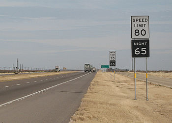
and I-10
in certain counties named in the statute, all of which happen to be rural, in west Texas, and have a low population density.
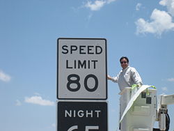 On May 25, 2006, the Texas Transportation Commission has approved 80 mph speed limits, and signs are posted.
In a widely printed Associated Press
story about the 80 mph speed limit, Texas is incorrectly reported as having legalized 75 mph limits in 1999. In fact, the bill that would have done this, HB 3328 by Pete Gallego
, died in conference committee just before the Texas Legislature
's session ended. This bill would have, in effect, set 75 mph as the statutory speed limit on any rural road numbered by the state or federal government, and it would have enacted—not simply allowed—an 80 mph speed limit on I-10 and I-20 in any county with fewer than 25,000 residents.
While Texas's 80 mph limit is higher than any limit authorized by another state except Utah
, it is lower than the 130 km/h recommended speed on the Autobahn and the actual 130 km/h rural expressway speed limit in thirteen other European countries.
is 55 mph and is found on one road, the divided Melvin H. Evans Highway on the island of St. Croix. Outside of towns, these vehicles are limited to 35 mph unless posted lower, except on the above mentioned divided highway
and parts of Centerline Road, which is limited to 40 mph. Within towns, these vehicles are limited to twenty miles per hour.
"Motor trucks and buses" are limited to 40 mph on St. Croix's main divided highway, 30 mph on other highway
s outside of towns, and ten miles per hour within towns.
, there is a minimum speed limit of 45 mph on Interstate Highways when conditions permit. The maximum speed limit on Interstates is 65 mph in cities and, on most highways, 75 mph elsewhere. In January 2009, the speed limit on two sections of I-15
together totaling 35 miles was raised to 80 mph as a "test." Although still posted as "experimental", the Utah DOT announced at the end of 2009 that the test had been successful and the speed limit is still posted as 80 mph.
statute provides that the default speed limit "shall be 55 mph on interstate highways or other limited access highways with divided roadways, nonlimited access highways having four or more lanes, and all state primary highways." "The maximum speed limit on all other highways shall be 55 miles per hour if the vehicle is a passenger motor vehicle, bus, pickup or panel truck, or a motorcycle, but 45 miles per hour on such highways if the vehicle is a truck, tractor truck, or combination of vehicles designed to transport property, or is a motor vehicle being used to tow a vehicle designed for self-propulsion, or a house trailer." The same statute contains a number of exceptions, however, allowing higher speed limits "where indicated by lawfully placed signs, erected subsequent to a traffic engineering study and analysis of available and appropriate accident and law-enforcement data." This provision allows speed limits of up to 70 mph on Interstate highways; multilane, divided, limited-access highways; and high-occupancy vehicle lane
s if said lanes are physically separated from the regular travel lanes. (As of July 2010, Virginia has two such barrier-separated HOV facilities, one on I-95
and I-395 and the other on I-64
.) The statute also allows 60-mph speed limits on a number of specified non-limited access, multilane, divided highways.
The 70-mph provision was added to Section 46.2-870 via an amendment effective on July 1, 2010. The previous version of the statute had authorized a 70-mph speed limit only on I-85
; the maximum limit permitted elsewhere was 65 mph. Notably, the revised statute does not require a 70-mph speed limit on any road nor make such limit automatic, due to the requirement for traffic and engineering studies. The Virginia Department of Transportation began studying Interstate highways with 65-mph speed limits during April 2010 to determine which roads should receive the 70-mph limit and announced that the studies would be conducted in three phases over a period of several months, with the initial phase focusing on 323 miles of highway with "no significant levels of crashes and congestion." As of July 1, 2010, VDOT increased the speed limit to 70 mph on a portion of one highway (I-295
south of I-64
). On October 20, 2010, Governor Bob McDonnell
announced that by the end of 2010, VDOT would post 70-mph speed limits on 680 miles of Virginia Interstates located outside of urban areas, representing 61 percent of Virginia's total 1,119 miles of Interstate highways. Notably, while the amended statute allows 70-mph speed limits on routes other than Interstates, as of October 2010 VDOT had not considered any such roads for the higher speed limit. Even though there are 70-mph speed limits, traveling just 11 mph over that limit in such a zone is prosecutable as a misdemeanor with penalties of up to a $2,500 fine and/or 12 months in jail.
Other Virginia statutes prescribe exceptions to the general rules set forth above. The notable aspect of Virginia's current speed limit laws is that the Department of Transportation has no authority to raise speed limits above the statutory limits unless the General Assembly passes a statute permitting the change. Since the National Maximum Speed Law
was repealed in 1995, such statutory exceptions were largely confined to a highway-by-highway basis, as evidenced by the list of 60-mph exceptions in Va. Code § 46.2-870.
Virginia law does not prescribe a fixed minimum speed limit, although a statute does authorize the posting of such limits where traffic and engineering studies indicate that they would be appropriate.
Virginia is the only US state that prohibits the use of radar detector
s.
is 55 mph unless otherwise posted. There are designated speeds set by law for highways and certain areas such as school zones, business and residential districts. Although speed limits are posted, a driver may not drive faster than is reasonable and prudent for conditions. In 1997 the speed limit of 65 mph on most interstates in West Virginia
was increased. Now most West Virginia
interstates have a posted speed limit of 70 mph for all vehicles with no truck
or night
speed limit with a few exceptions. A section of The West Virginia Turnpike
through a very curvy portion is posted at 60 mph. I-64
is posted at 65 mph through Huntington. Much of the interstate highways around Charleston are posted at 60 mph due to the heavy urban
traffic. There is a truck
speed limit of 45 mph (along with other traffic at 70 mph) at the 7% downgrade of Sandstone Mountain on I-64
. Divided multilane highways that are not interstates have a speed limit of 65 mph with a few cases of them having a limit of 55 mph (lower in urban
areas.) An example of a multilane highway
with a 65 mph limit in West Virginia
would be U.S. Route 19/Mountaineer Expressway. Open country highways have a statutory limit of 55 mph which includes most rural
two lane highways and even includes some one lane back country roads or any road without a posted speed limit. Cities and towns set their own speed limits which are usually between 25 and 55 mph (depending on where the road is, width, lanes, traffic
, etc.) Until 2011, school zones in West Virginia
had a statutory speed limit of 15 mph no matter the normal speed of the road. Implemented at the start of the 2011-2012 school year, roads with a speed limit of 55 mph or higher now have an advisory speed of 35 mph in school zones when children are present. A school zone includes 200 feet abutting in both directions of the school or school entrance road. Speed limits may be changed due to construction. Work zone speed limits vary, usually dropping about 15 mph from the original speed limit. All penalties are doubled for traffic violations in a work zone.
's speed limits are set out in statutory law but may often be modified by the maintaining government entity. In addition to a basic speed rule, Wisconsin law specifies certain occasions where reduced speeds are required includingand not limited to the approaches and traverses of rail crossing
s, winding roads, roads where people are present, and the crests of grades. Although there is no numeric minimum speed limit, state law prohibits the impediment of traffic by unreasonably slow speeds. Vehicles which lack rubber tire
s filled with compressed air have a hard limit of 15 mph.
The state of Wisconsin has four default speed limits. 15 mph limits apply in school zone
s, near parks with children, and in alley
s. 5 mph default speed limits apply, unless modified by the managing authority, on "service roads" within corporate limits. Within municipal boundaries and in areas of dense urban development a 35 mph limit is in effect unless another speed limit is indicated. The entry to such an area is to be marked by speed limit signs. Outside of built-up areas (these include denser business, industrial or residential land uses according to the relevant law) a 55 mph limit is effective in the absence of other indications.
Along with the aforementioned default speed limits, there are other statutory speed limits which more often require signs to be effective. 65 mph limits on freeways and expressways
require signs to be effective. The default speed limit on these types of roads is 55 mph as they do not directly interact with the built-up environment. In the densest urban districts a statutory 25 mph limit is effective when adequate signage is used, as are 35 mph limits in areas of light development. The same applies to 45 mph limits on highways designated as "rustic" roads. However, "an alleged failure to post [such a speed limit sign] is not a defense to a prosecution" in the case of such statutory limits.
U.S. state
A U.S. state is any one of the 50 federated states of the United States of America that share sovereignty with the federal government. Because of this shared sovereignty, an American is a citizen both of the federal entity and of his or her state of domicile. Four states use the official title of...
or territory. Speed limits in the United States vary according to many factors, including each state or territory's laws, the type of road, land use
Land use
Land use is the human use of land. Land use involves the management and modification of natural environment or wilderness into built environment such as fields, pastures, and settlements. It has also been defined as "the arrangements, activities and inputs people undertake in a certain land cover...
, and more. Increments of five miles per hour are used. Additionally, these limits sometimes differ according to the type of vehicle and the time of day. Occasionally there are also minimum speed limits.
Most speed limits are set by the legislatures of states and territories as law statutes. States generally allow a statewide transportation agency and lesser authorities to change speed limits. The first speed limit in the territory which is now the United States was set in Boston in 1757 by the board of selectmen (ie a sort of city council). The speed limit for wagons, carriages, horses, etc. on Sunday was set at a walking pace. Anyone exceeding this limit would be fined 10 Shillings.
For approximately thirteen years (1974–1987), no speed limit in the United States exceeded 55 mph (89 km/h). Prior to that, speed limits were mostly the same as today, but more often higher or nonexistent in rural areas. Montana and Nevada among others previously had no statutory speed limits for cars and motorcycles under certain conditions. Also, it should be noted that from 1995 to 2011, speed limits higher than 70 mph were restricted to the Great Plains and the Mountain west, except for in Oregon, California, and Washington.
The highest speed limits are usually found in the inland West, and the lowest limits are usually found in the Northeast with the exception of Maine
Maine
Maine is a state in the New England region of the northeastern United States, bordered by the Atlantic Ocean to the east and south, New Hampshire to the west, and the Canadian provinces of Quebec to the northwest and New Brunswick to the northeast. Maine is both the northernmost and easternmost...
, which raised its speed limit for a remote stretch of Interstate 95 through the northern part of the state to 75 mph in June 2011. Some limits fall outside these ranges. For example, some two-lane rural roads in Texas have 75 mph (121 km/h) speed limits, and there are two stretches of Interstate Highway in Texas with a daytime 80 mph (129 km/h) speed limit for passenger vehicles, as well as two stretches in Utah with 80 mph limits tested in 2009. In contrast, the highest speed limit on freeways in Hawaii is 60 mph (97 km/h). A statute effective June 17, 2011, authorizes 85-mph speed limits in Texas, although the new law requires traffic and engineering studies before the higher limit takes effect.
Speed limits
This table contains the most usual daytime speed limits, in miles per hourMiles per hour
Miles per hour is an imperial unit of speed expressing the number of statute miles covered in one hour. It is currently the standard unit used for speed limits, and to express speeds generally, on roads in the United Kingdom and the United States. It is also often used to express the speed of...
, on typical road
Road
A road is a thoroughfare, route, or way on land between two places, which typically has been paved or otherwise improved to allow travel by some conveyance, including a horse, cart, or motor vehicle. Roads consist of one, or sometimes two, roadways each with one or more lanes and also any...
s in each category. The values shown are not necessarily the fastest or slowest. They usually indicate, but not always, statutory
Statutory law
Statutory law or statute law is written law set down by a legislature or by a legislator .Statutes may originate with national, state legislatures or local municipalities...
speed limits. Some states and territories have lower truck speed limits applicable to heavy trucks
Truck
A truck or lorry is a motor vehicle designed to transport cargo. Trucks vary greatly in size, power, and configuration, with the smallest being mechanically similar to an automobile...
. If present, they are usually only on freeways or other high speed roadways.
| Legend: | ||
|---|---|---|
Freeway: Interstate Highway or other state State highway State highway, state road or state route can refer to one of three related concepts, two of them related to a state or provincial government in a country that is divided into states or provinces :#A... or U.S. Route United States Numbered Highways The system of United States Numbered Highways is an integrated system of roads and highways in the United States numbered within a nationwide grid... built to Interstate standards. Divided rural Divided Highway Divided Highway is a compilation album by American rock band The Doobie Brothers, released in 2003. . All tracks are taken from the albums Cycles and Brotherhood .-Track listing:... : State or U.S. route, generally with four or more lanes, not built to Interstate standards, but with a median or other divider separating directions of travel. Undivided rural: State or U.S. route, generally with two to four lanes, with no separator between directions of travel. County County highway A county highway is a road in the United States and in the Canadian province of Ontario that is designated and/or maintained by the county highway department... : County-owned roads that are generally not numbered by the state. Major road through residential area/residential: Residential street Street A street is a paved public thoroughfare in a built environment. It is a public parcel of land adjoining buildings in an urban context, on which people may freely assemble, interact, and move about. A street can be as simple as a level patch of dirt, but is more often paved with a hard, durable... s or business districts. Residential Street/residential: Residential street Street A street is a paved public thoroughfare in a built environment. It is a public parcel of land adjoining buildings in an urban context, on which people may freely assemble, interact, and move about. A street can be as simple as a level patch of dirt, but is more often paved with a hard, durable... s or business districts. School zone School zone A school zone refers to an area on a street near a school or near a crosswalk leading to a school that has a likely presence of younger pedestrians. School zones generally have a reduced speed limit during certain hours.-Fines:... : An area on a street near a school or near a crosswalk leading to a school that has a likely presence of pedestrians. |
||
{|class="wikitable" style="text-align:center"
!State or territory!!Freeway (rural)!!Freeway (trucks)!!Freeway (urban)!!Divided (rural)!!Undivided (rural)!!County (rural)!!Residential divided (urban)!!Residential undivided (urban)!!School zone
|-
|align="left"|
AlabamaAlabama
Alabama is a state located in the southeastern region of the United States. It is bordered by Tennessee to the north, Georgia to the east, Florida and the Gulf of Mexico to the south, and Mississippi to the west. Alabama ranks 30th in total land area and ranks second in the size of its inland...
||colspan="2"|70||60||65||55||35–45||25||25||15
|-
|align="left"|
AlaskaAlaska
Alaska is the largest state in the United States by area. It is situated in the northwest extremity of the North American continent, with Canada to the east, the Arctic Ocean to the north, and the Pacific Ocean to the west and south, with Russia further west across the Bering Strait...
||colspan="2"|65||65||65||65||50||25||||20
|-
|align="left"|
American SamoaAmerican Samoa
American Samoa is an unincorporated territory of the United States located in the South Pacific Ocean, southeast of the sovereign state of Samoa...
||–||–||–||–||25–30||–||||15||
|-
|align="left"|
ArizonaArizona
Arizona ; is a state located in the southwestern region of the United States. It is also part of the western United States and the mountain west. The capital and largest city is Phoenix...
||colspan="2"|75||65||65||65||65||25||||15
|-
|align="left"|
ArkansasArkansas
Arkansas is a state located in the southern region of the United States. Its name is an Algonquian name of the Quapaw Indians. Arkansas shares borders with six states , and its eastern border is largely defined by the Mississippi River...
||70||65||65||60–65||55||||||||
|-
|align="left"|
CaliforniaCalifornia
California is a state located on the West Coast of the United States. It is by far the most populous U.S. state, and the third-largest by land area...
||70||55||55-65||65||55–65||55–65||25||||25
|-
|align="left"|
ColoradoColorado
Colorado is a U.S. state that encompasses much of the Rocky Mountains as well as the northeastern portion of the Colorado Plateau and the western edge of the Great Plains...
||colspan="2"|65-75||55–65||65||65||35–55||25–35||||20–25
|-
|align="left"|
ConnecticutConnecticut
Connecticut is a state in the New England region of the northeastern United States. It is bordered by Rhode Island to the east, Massachusetts to the north, and the state of New York to the west and the south .Connecticut is named for the Connecticut River, the major U.S. river that approximately...
||colspan="2"|65||45-55||55||55||45||25-40||||20
|-
|align="left"|
DelawareDelaware
Delaware is a U.S. state located on the Atlantic Coast in the Mid-Atlantic region of the United States. It is bordered to the south and west by Maryland, and to the north by Pennsylvania...
||colspan="2"|65||50-55||55||50||||25-35||||20
|-
|align="left"|
District of Columbia||-||-||50||-||-||-||25||||15|-
|align="left"|
FloridaFlorida
Florida is a state in the southeastern United States, located on the nation's Atlantic and Gulf coasts. It is bordered to the west by the Gulf of Mexico, to the north by Alabama and Georgia and to the east by the Atlantic Ocean. With a population of 18,801,310 as measured by the 2010 census, it...
||colspan="2"|70||55-65||65||60||55-60||30||||10-20
|-
|align="left"|
GeorgiaGeorgia (U.S. state)
Georgia is a state located in the southeastern United States. It was established in 1732, the last of the original Thirteen Colonies. The state is named after King George II of Great Britain. Georgia was the fourth state to ratify the United States Constitution, on January 2, 1788...
||colspan="2"|70||55-65||65||55||-||30||25-45||
|-
|align="left"|
GuamGuam
Guam is an organized, unincorporated territory of the United States located in the western Pacific Ocean. It is one of five U.S. territories with an established civilian government. Guam is listed as one of 16 Non-Self-Governing Territories by the Special Committee on Decolonization of the United...
||-||-||-||35-45||35-45||-||||||
|-
|align="left"|
HawaiiHawaii
Hawaii is the newest of the 50 U.S. states , and is the only U.S. state made up entirely of islands. It is the northernmost island group in Polynesia, occupying most of an archipelago in the central Pacific Ocean, southwest of the continental United States, southeast of Japan, and northeast of...
||colspan="2"|55-60||50||45||45||45||||||
|-
|align="left"|
IdahoIdaho
Idaho is a state in the Rocky Mountain area of the United States. The state's largest city and capital is Boise. Residents are called "Idahoans". Idaho was admitted to the Union on July 3, 1890, as the 43rd state....
||75||65||65||65||65||50-65||||||20
|-
|align="left"|
IllinoisIllinois
Illinois is the fifth-most populous state of the United States of America, and is often noted for being a microcosm of the entire country. With Chicago in the northeast, small industrial cities and great agricultural productivity in central and northern Illinois, and natural resources like coal,...
||colspan="2"|65||55-65||65||55||55||30||||20
|-
|align="left"|
IndianaIndiana
Indiana is a US state, admitted to the United States as the 19th on December 11, 1816. It is located in the Midwestern United States and Great Lakes Region. With 6,483,802 residents, the state is ranked 15th in population and 16th in population density. Indiana is ranked 38th in land area and is...
||70||65||50-65||60||55||55||20-30||||20-25
|-
|align="left"|
IowaIowa
Iowa is a state located in the Midwestern United States, an area often referred to as the "American Heartland". It derives its name from the Ioway people, one of the many American Indian tribes that occupied the state at the time of European exploration. Iowa was a part of the French colony of New...
||colspan="2"|70||55-65||65||55||45||25||||25
|-
|align="left"|
KansasKansas
Kansas is a US state located in the Midwestern United States. It is named after the Kansas River which flows through it, which in turn was named after the Kansa Native American tribe, which inhabited the area. The tribe's name is often said to mean "people of the wind" or "people of the south...
||colspan="2"|75||65||65-70||65||55||30||||20
|-
|align="left"|
KentuckyKentucky
The Commonwealth of Kentucky is a state located in the East Central United States of America. As classified by the United States Census Bureau, Kentucky is a Southern state, more specifically in the East South Central region. Kentucky is one of four U.S. states constituted as a commonwealth...
||colspan="2"|70-75||50-55||55||55||55||25-35||||25-45
|-
|align="left"|
LouisianaLouisiana
Louisiana is a state located in the southern region of the United States of America. Its capital is Baton Rouge and largest city is New Orleans. Louisiana is the only state in the U.S. with political subdivisions termed parishes, which are local governments equivalent to counties...
||colspan="2"|70-75||60||65||55||45||10-30||10-30||20-45
|-
|align="left"|
MaineMaine
Maine is a state in the New England region of the northeastern United States, bordered by the Atlantic Ocean to the east and south, New Hampshire to the west, and the Canadian provinces of Quebec to the northwest and New Brunswick to the northeast. Maine is both the northernmost and easternmost...
||colspan="2"|65-75||55||55||55||50||||||
|-
|align="left"|
MarylandMaryland
Maryland is a U.S. state located in the Mid Atlantic region of the United States, bordering Virginia, West Virginia, and the District of Columbia to its south and west; Pennsylvania to its north; and Delaware to its east...
||colspan="2"|65||55-65||55||50-55||||||||15-25
|-
|align="left"|
MassachusettsMassachusetts
The Commonwealth of Massachusetts is a state in the New England region of the northeastern United States of America. It is bordered by Rhode Island and Connecticut to the south, New York to the west, and Vermont and New Hampshire to the north; at its east lies the Atlantic Ocean. As of the 2010...
||colspan="2"|65||55||55||55||||30||||20
|-
|align="left"|
MichiganMichigan
Michigan is a U.S. state located in the Great Lakes Region of the United States of America. The name Michigan is the French form of the Ojibwa word mishigamaa, meaning "large water" or "large lake"....
||70||60||55-70||55-65||55||55||25||||25
|-
|align="left"|
MinnesotaMinnesota
Minnesota is a U.S. state located in the Midwestern United States. The twelfth largest state of the U.S., it is the twenty-first most populous, with 5.3 million residents. Minnesota was carved out of the eastern half of the Minnesota Territory and admitted to the Union as the thirty-second state...
||colspan="2"|70||45-60||55-65||55-60||55||30||||
|-
|align="left"|
MississippiMississippi
Mississippi is a U.S. state located in the Southern United States. Jackson is the state capital and largest city. The name of the state derives from the Mississippi River, which flows along its western boundary, whose name comes from the Ojibwe word misi-ziibi...
||colspan="2"|70||60-70||65||55||||25||||
|-
|align="left"|
MissouriMissouri
Missouri is a US state located in the Midwestern United States, bordered by Iowa, Illinois, Kentucky, Tennessee, Arkansas, Oklahoma, Kansas and Nebraska. With a 2010 population of 5,988,927, Missouri is the 18th most populous state in the nation and the fifth most populous in the Midwest. It...
||colspan="2"|70||45-65||55-70||55-65||55||25||||20
|-
!State or territory!!Freeway (rural)!!Freeway (trucks)!!Freeway (urban)!!Divided (rural)!!Undivided (rural)!!County (rural)!!Residential divided (urban)!!Residential undivided (urban)!!School zone
|-
|align="left"|
MontanaMontana
Montana is a state in the Western United States. The western third of Montana contains numerous mountain ranges. Smaller, "island ranges" are found in the central third of the state, for a total of 77 named ranges of the Rocky Mountains. This geographical fact is reflected in the state's name,...
||75||65||65||70||55-70||55-70||25||||15
|-
|align="left"|
NebraskaNebraska
Nebraska is a state on the Great Plains of the Midwestern United States. The state's capital is Lincoln and its largest city is Omaha, on the Missouri River....
||colspan="2"|75||60||65||55-65||50-55||25||||25
|-
|align="left"|
NevadaNevada
Nevada is a state in the western, mountain west, and southwestern regions of the United States. With an area of and a population of about 2.7 million, it is the 7th-largest and 35th-most populous state. Over two-thirds of Nevada's people live in the Las Vegas metropolitan area, which contains its...
||colspan="2"|75||60-65||65-70||55-70||55-70||25||||15, 25
|-
|align="left"|
New HampshireNew Hampshire
New Hampshire is a state in the New England region of the northeastern United States of America. The state was named after the southern English county of Hampshire. It is bordered by Massachusetts to the south, Vermont to the west, Maine and the Atlantic Ocean to the east, and the Canadian...
||colspan="2"|65||55||55||55||35||30||||20
|-
|align="left"|
New JerseyNew Jersey
New Jersey is a state in the Northeastern and Middle Atlantic regions of the United States. , its population was 8,791,894. It is bordered on the north and east by the state of New York, on the southeast and south by the Atlantic Ocean, on the west by Pennsylvania and on the southwest by Delaware...
||colspan="2"|65||55||55||45-55||30-50||25||||15-35
|-
|align="left"|
New MexicoNew Mexico
New Mexico is a state located in the southwest and western regions of the United States. New Mexico is also usually considered one of the Mountain States. With a population density of 16 per square mile, New Mexico is the sixth-most sparsely inhabited U.S...
||colspan="2"|75||65-75||65-70||55-65||25-55||25-30||||15-20
|-
|align="left"|
New YorkNew York
New York is a state in the Northeastern region of the United States. It is the nation's third most populous state. New York is bordered by New Jersey and Pennsylvania to the south, and by Connecticut, Massachusetts and Vermont to the east...
||colspan="2"|65||50-55||55||55||55||30||||
|-
|align="left"|
North CarolinaNorth Carolina
North Carolina is a state located in the southeastern United States. The state borders South Carolina and Georgia to the south, Tennessee to the west and Virginia to the north. North Carolina contains 100 counties. Its capital is Raleigh, and its largest city is Charlotte...
||colspan="2"|70||60-65||55-60*||55||||20-35||20-35||20-35
|-
|align="left"|
North DakotaNorth Dakota
North Dakota is a state located in the Midwestern region of the United States of America, along the Canadian border. The state is bordered by Canada to the north, Minnesota to the east, South Dakota to the south and Montana to the west. North Dakota is the 19th-largest state by area in the U.S....
||colspan="2"|75||55-75||70||40-65||40-55||30-55||20-45||15-25
|-
|align="left"|
OhioOhio
Ohio is a Midwestern state in the United States. The 34th largest state by area in the U.S.,it is the 7th‑most populous with over 11.5 million residents, containing several major American cities and seven metropolitan areas with populations of 500,000 or more.The state's capital is Columbus...
||colspan="2"|65-70||55-65||55-65||55||55||25-35||||20
|-
|align="left"|
OklahomaOklahoma
Oklahoma is a state located in the South Central region of the United States of America. With an estimated 3,751,351 residents as of the 2010 census and a land area of 68,667 square miles , Oklahoma is the 28th most populous and 20th-largest state...
||colspan="2"|70-75||55-65||60-70||55-65||45||25||||25
|-
|align="left"|
OregonOregon
Oregon is a state in the Pacific Northwest region of the United States. It is located on the Pacific coast, with Washington to the north, California to the south, Nevada on the southeast and Idaho to the east. The Columbia and Snake rivers delineate much of Oregon's northern and eastern...
||65†||55||50-60||55||55||55||25||||20
|-
|align="left"|
PennsylvaniaPennsylvania
The Commonwealth of Pennsylvania is a U.S. state that is located in the Northeastern and Mid-Atlantic regions of the United States. The state borders Delaware and Maryland to the south, West Virginia to the southwest, Ohio to the west, New York and Ontario, Canada, to the north, and New Jersey to...
||colspan="2"|65||55-65||55||55||35-45||25-35
Pennsylvania
The Commonwealth of Pennsylvania is a U.S. state that is located in the Northeastern and Mid-Atlantic regions of the United States. The state borders Delaware and Maryland to the south, West Virginia to the southwest, Ohio to the west, New York and Ontario, Canada, to the north, and New Jersey to...
||20-35||15
|-
|align="left"|
Puerto RicoPuerto Rico
Puerto Rico , officially the Commonwealth of Puerto Rico , is an unincorporated territory of the United States, located in the northeastern Caribbean, east of the Dominican Republic and west of both the United States Virgin Islands and the British Virgin Islands.Puerto Rico comprises an...
||60-65||50-55||||||45-55||-||25-35||||15-25
|-
|align="left"|
Rhode IslandRhode Island
The state of Rhode Island and Providence Plantations, more commonly referred to as Rhode Island , is a state in the New England region of the United States. It is the smallest U.S. state by area...
||colspan="2"|65||55||55||50||-||25||||20
|-
|align="left"|
South CarolinaSouth Carolina
South Carolina is a state in the Deep South of the United States that borders Georgia to the south, North Carolina to the north, and the Atlantic Ocean to the east. Originally part of the Province of Carolina, the Province of South Carolina was one of the 13 colonies that declared independence...
||colspan="2"|70||60||60||55||-||30||||
|-
|align="left"|
South DakotaSouth Dakota
South Dakota is a state located in the Midwestern region of the United States. It is named after the Lakota and Dakota Sioux American Indian tribes. Once a part of Dakota Territory, South Dakota became a state on November 2, 1889. The state has an area of and an estimated population of just over...
||colspan="2"|75||55-65||65-70||45-65||35-55||25-45||||15-25
|-
|align="left"|
TennesseeTennessee
Tennessee is a U.S. state located in the Southeastern United States. It has a population of 6,346,105, making it the nation's 17th-largest state by population, and covers , making it the 36th-largest by total land area...
||colspan="2"|70||55-70||65-70||55||35-45||20-45||||15-20
|-
|align="left"|
TexasTexas
Texas is the second largest U.S. state by both area and population, and the largest state by area in the contiguous United States.The name, based on the Caddo word "Tejas" meaning "friends" or "allies", was applied by the Spanish to the Caddo themselves and to the region of their settlement in...
||colspan="2"|70-80||55-65||70-75||70-75||30-60||30||||15-55
|-
|align="left"|
U.S. Virgin IslandsUnited States Virgin Islands
The Virgin Islands of the United States are a group of islands in the Caribbean that are an insular area of the United States. The islands are geographically part of the Virgin Islands archipelago and are located in the Leeward Islands of the Lesser Antilles.The U.S...
||-||-||-||55||35||-||20||||
|-
|align="left"|
UtahUtah
Utah is a state in the Western United States. It was the 45th state to join the Union, on January 4, 1896. Approximately 80% of Utah's 2,763,885 people live along the Wasatch Front, centering on Salt Lake City. This leaves vast expanses of the state nearly uninhabited, making the population the...
||colspan="2"|75-80||65||65||65||||25-35||||20
|-
|align="left"|
VermontVermont
Vermont is a state in the New England region of the northeastern United States of America. The state ranks 43rd in land area, , and 45th in total area. Its population according to the 2010 census, 630,337, is the second smallest in the country, larger only than Wyoming. It is the only New England...
||colspan="2"|65||55||55||50||50||||||
|-
|align="left"|
VirginiaVirginia
The Commonwealth of Virginia , is a U.S. state on the Atlantic Coast of the Southern United States. Virginia is nicknamed the "Old Dominion" and sometimes the "Mother of Presidents" after the eight U.S. presidents born there...
||colspan="2"|65-70||55-65||55-60||55|| ||25||||15-35
|-
|align="left"|
Washington||70||60||60||65||65||50-55||25-50||||20-25|-
|align="left"|
West VirginiaWest Virginia
West Virginia is a state in the Appalachian and Southeastern regions of the United States, bordered by Virginia to the southeast, Kentucky to the southwest, Ohio to the northwest, Pennsylvania to the northeast and Maryland to the east...
||colspan="2"|70||60-65||65||55||55|||25-55||||15 or 35
|-
|align="left"|
WisconsinWisconsin
Wisconsin is a U.S. state located in the north-central United States and is part of the Midwest. It is bordered by Minnesota to the west, Iowa to the southwest, Illinois to the south, Lake Michigan to the east, Michigan to the northeast, and Lake Superior to the north. Wisconsin's capital is...
||colspan="2"|65||55-65||55-65||55-65||55||25-35||||15
|-
|align="left"|
WyomingWyoming
Wyoming is a state in the mountain region of the Western United States. The western two thirds of the state is covered mostly with the mountain ranges and rangelands in the foothills of the Eastern Rocky Mountains, while the eastern third of the state is high elevation prairie known as the High...
||colspan="2"|75||65||65||65||||||||
|}
| legend: | ||
|---|---|---|
Freeway: Interstate Highway or other state State highway State highway, state road or state route can refer to one of three related concepts, two of them related to a state or provincial government in a country that is divided into states or provinces :#A... - or federally-numbered road built to Interstate standards. Divided Divided Highway Divided Highway is a compilation album by American rock band The Doobie Brothers, released in 2003. . All tracks are taken from the albums Cycles and Brotherhood .-Track listing:... : State- or federally-numbered road, generally with four or more lanes, not built to Interstate standards, but with a median or other divider separating directions of travel. Undivided: State- or federally-numbered road, generally with two to four lanes, with no separator between directions of travel. County County highway A county highway is a road in the United States and in the Canadian province of Ontario that is designated and/or maintained by the county highway department... : County-owned roads that are generally not numbered by the state. Divided urban/residential: Residential street Street A street is a paved public thoroughfare in a built environment. It is a public parcel of land adjoining buildings in an urban context, on which people may freely assemble, interact, and move about. A street can be as simple as a level patch of dirt, but is more often paved with a hard, durable... s or business districts. Undivided urban/residential: Residential street Street A street is a paved public thoroughfare in a built environment. It is a public parcel of land adjoining buildings in an urban context, on which people may freely assemble, interact, and move about. A street can be as simple as a level patch of dirt, but is more often paved with a hard, durable... s or business districts. School zone School zone A school zone refers to an area on a street near a school or near a crosswalk leading to a school that has a likely presence of younger pedestrians. School zones generally have a reduced speed limit during certain hours.-Fines:... : An area on a street near a school or near a crosswalk leading to a school that has a likely presence of pedestrians. |
||
† Oregon state law permits a maximum statewide speed limit of 70 mph, but gives the Oregon Department of Transportation discretion in selecting which roads to post at 70 mph. Currently ODOT has not identified any roadways whose speed limits should be raised to 70 mph. Thus, the highest posted speed limit seen in Oregon is 65 mph.
Examples of related laws
| State | Typical fine | Recklessness threshold or enhanced penalty | Absolute/prima facie Prima facie Prima facie is a Latin expression meaning on its first encounter, first blush, or at first sight. The literal translation would be "at first face", from the feminine form of primus and facies , both in the ablative case. It is used in modern legal English to signify that on first examination, a... | Ticket dismissal options | Point system |
|---|---|---|---|---|---|
| Pennsylvania Pennsylvania The Commonwealth of Pennsylvania is a U.S. state that is located in the Northeastern and Mid-Atlantic regions of the United States. The state borders Delaware and Maryland to the south, West Virginia to the southwest, Ohio to the west, New York and Ontario, Canada, to the north, and New Jersey to... |
$35 plus court and other costs. All fines doubled in active work zones. | >30 mph over limit | Absolute | None | Point system leads to mandatory driver education and possible license suspension. |
| Texas |
$1–$200 plus court fees. Doubled in active school zone or construction zone when workers are present. Various additional "fees" assessed by the state essentially increase the fine by around $100 on all tickets. | None | Prima facie | Defensive driving (once per year) or deferred disposition (restrictions vary, but generally at least 4 per year), but only valid if:
|
Point system is annual surcharge only. No provision for license suspension. |
| Rhode Island Rhode Island The state of Rhode Island and Providence Plantations, more commonly referred to as Rhode Island , is a state in the New England region of the United States. It is the smallest U.S. state by area... |
Prima facie | One dismissal every 3 years for speed 14 mph or less over limit. | |||
| Virginia Virginia The Commonwealth of Virginia , is a U.S. state on the Atlantic Coast of the Southern United States. Virginia is nicknamed the "Old Dominion" and sometimes the "Mother of Presidents" after the eight U.S. presidents born there... |
|
20 mph over limit or over 80 mph or "exceeds reasonable speed". | Absolute | Point system leading to fines, suspension, and mandatory driver education. |
Minimum speed limits
Comparable to the common basic speed rule, most jurisdictions also have laws prohibiting speeds so low they are dangerous or impede the normal and reasonable flow of traffic
Traffic flow
Traffic flow, in mathematics and civil engineering, is the study of interactions between vehicles, drivers, and infrastructure , with the aim of understanding and developing an optimal road network with efficient movement of traffic and minimal traffic congestion problems.-History:Attempts to...
.
Truck speed limits
Truck
A truck or lorry is a motor vehicle designed to transport cargo. Trucks vary greatly in size, power, and configuration, with the smallest being mechanically similar to an automobile...
and buses. While they are called "truck speed limits", they generally do not apply to light truck
Light truck
Light truck or light duty truck is a U.S. classification for trucks or truck-based vehicles with a payload capacity of less than 4,000 pounds...
s.
Theory
Because trucks, considered as class 7 and 8Truck classification
In the United States, commercial truck classification is determined based on the vehicle's gross vehicle weight rating . The classes range from 1-8...
, are far heavier than other vehicles, they take longer to stop, are less adept at avoiding hazards, and have much more momentum. Therefore, it follows from basic physics that limiting truck speeds could reduce the severity and incidence of truck-related crashes.
However, the research record is mixed. A 1987 study finds that crash involvement significantly increases when trucks drive much slower than passenger vehicles, suggesting that the difference in speed between passenger vehicles and slower trucks could cause crashes that otherwise may not happen. Furthermore, in a review of available research, the Transportation Research Board
Transportation Research Board
The Transportation Research Board is a division of the National Research Council, which serves as an independent adviser to the President, the Congress and federal agencies on scientific and technical questions of national importance...
(part of the United States National Research Council
United States National Research Council
The National Research Council of the USA is the working arm of the United States National Academies, carrying out most of the studies done in their names.The National Academies include:* National Academy of Sciences...
) states "
Two thirds (67%) of truck/passenger car crashes are the fault of the passenger vehicle.
Night speed limits
Montana also uses night speed limits statewide on federal, state and secondary roads. They were once used on interstates but only until 1999.
Night speed limits are indicated on some streets in Tucson, Arizona
Tucson, Arizona
Tucson is a city in and the county seat of Pima County, Arizona, United States. The city is located 118 miles southeast of Phoenix and 60 miles north of the U.S.-Mexico border. The 2010 United States Census puts the city's population at 520,116 with a metropolitan area population at 1,020,200...
without street lights.
Some roads in Florida have night speed limits near SW Florida Int'l Airport near Cape Coral / Fort Myers.
Colorado Highway 13 has a 65 day/55 night speed limit beginning 7.1 mi. north of I-70 from north of Rifle to CO. Hwy. 64 south of Meeker.
Rural CO. Hwy. 13 is 55 mph at night north of Meeker all the way to the Wyoming state line.
Arbitrariness
- Rural sections of Interstate 84Interstate 84Interstate 84 may refer to:*Interstate 84 , a freeway extending from Scranton, Pennsylvania to Sturbridge, Massachusetts at the Massachusetts Turnpike *Interstate 84 , a freeway extending from Portland, Oregon to Echo, Utah...
in Oregon and Idaho have a 10-mph speed limit difference, Oregon being posted at 65 mph while Idaho maintains a 75 mph speed limit. - All 51 miles (82 km) of I-95Interstate 95 in PennsylvaniaInterstate 95 is an Interstate highway running from Miami, Florida north to Houlton, Maine. In the U.S. state of Pennsylvania, the route is known by many as the Delaware Expressway, but is officially named The Vietnam Veterans Memorial Highway. and locally known as "95"...
in PennsylvaniaPennsylvaniaThe Commonwealth of Pennsylvania is a U.S. state that is located in the Northeastern and Mid-Atlantic regions of the United States. The state borders Delaware and Maryland to the south, West Virginia to the southwest, Ohio to the west, New York and Ontario, Canada, to the north, and New Jersey to...
are posted at 55 mph, while in neighboring New JerseyNew JerseyNew Jersey is a state in the Northeastern and Middle Atlantic regions of the United States. , its population was 8,791,894. It is bordered on the north and east by the state of New York, on the southeast and south by the Atlantic Ocean, on the west by Pennsylvania and on the southwest by Delaware...
, the speed limit on I-95 is primarily 65 mph, despite their common suburban environment. - Interstate 95 from the Newark Toll Plaza south of Exit 1 at DE 896 to the Maryland State line is 55 mph. The speed limit goes up to 65 mph at the Maryland State line. The stretch of roadway between Exit 109 at MD 279 and prior to Exit 1 at DE 896 before the Newark Toll Plaza are identical roadways.
- The lowest class of state-maintained, two-lane road in Texas may have a 70 mph speed limit, but a two-lane US highwayUnited States Numbered HighwaysThe system of United States Numbered Highways is an integrated system of roads and highways in the United States numbered within a nationwide grid...
built to neighboring Arkansas's or Louisiana's highest standards may not have a speed limit over 55. - Only three states allow two-lane highways to be posted at 70 mph or higher: Texas (mostly 70, but some west Texas 2 lane roads have 75 mph limits), Nevada, and Montana. Nevada and Texas are the only states to allow 70 mph on two-lane roads at night as well as during the day.
- Before night speed limits were abolished, Texas's rural Interstates highways generally had 65 mph night speed limits, but motorists were allowed to travel at 70 or 75 mph at night on all adjacent states' rural Interstates.
- Texas law in fact sets 70 mph as the default limit for all rural highways. Therefore, sometimes short stretches of Texas highway can have a 70 mph speed limit, such as:
- FM 2249 (from 1/2 mile west of FM 1437 in Dell City to 2 miles west of FM 1437 at Wood Rd. where the pavement ends) 1 miles.
- Texas Highway 17 (from I-10 to FM 1215 at Saragosa city limit) 1 miles.
- Texas Highway 302 is 70 mph for 9/10 mile east of Texas Highway 115 approaching Kermit, even through a rail road crossing before the speed limit lowers to 55 and then 50 at the city limit. Or westbound on TX 302 it is 70 mph before coming to a stop at the 115-302 intersection. TX 302 is 75 mph west of TX 115.
- Texas Highway 18 has a 75 mph speed limit for most of its route even for a 9 mile stretch north of Kermit to the New Mexico state line while Texas Highway 115 is 75 mph north of Kermit and 70 mph south of Kermit.
- Texas 41 is 70 mph for 2 miles from I-10 before coming to a stop sign on TX 27 near Mountain Home.
Environmental concerns
Reduced speed limits are sometimes enacted for air quality reasons. The most prominent example includes Texas's environmental speed limits, which do not appear to significantly contribute to air quality.Metric speed limits
Metric system
The metric system is an international decimalised system of measurement. France was first to adopt a metric system, in 1799, and a metric system is now the official system of measurement, used in almost every country in the world...
(km/h) as well as miles per hour (mph). The Federal Highway Administration
Federal Highway Administration
The Federal Highway Administration is a division of the United States Department of Transportation that specializes in highway transportation. The agency's major activities are grouped into two "programs," the Federal-aid Highway Program and the Federal Lands Highway Program...
's Manual on Uniform Traffic Control Devices
Manual on Uniform Traffic Control Devices
The Manual on Uniform Traffic Control Devices is a document issued by the Federal Highway Administration of the United States Department of Transportation to specify the standards by which traffic signs, road surface markings, and signals are designed, installed, and used...
, which provides guidelines for speed limit signage, states that "speed limits shown shall be in multiples of 10 km/h or 5 mph." If a speed limit sign indicates km/h, the number is circumscribed and "km/h" is written below. Prior to 2003, metric speed limits were designated using the standard speed limit sign, usually with yellow supplemental "METRIC" and "km/h" plaques above it and below it, respectively.
The 1995 National Highway System Designation Act prohibited use of federal funds to finance new metric signage.
Federal speed controls
National 55 mph limit
In response to the 1973 oil crisis1973 oil crisis
The 1973 oil crisis started in October 1973, when the members of Organization of Arab Petroleum Exporting Countries or the OAPEC proclaimed an oil embargo. This was "in response to the U.S. decision to re-supply the Israeli military" during the Yom Kippur war. It lasted until March 1974. With the...
, Congress
United States Congress
The United States Congress is the bicameral legislature of the federal government of the United States, consisting of the Senate and the House of Representatives. The Congress meets in the United States Capitol in Washington, D.C....
enacted the National Maximum Speed Law
National Maximum Speed Law
The National Maximum Speed Law in the United States was a provision of the 1974 Emergency Highway Energy Conservation Act that prohibited speed limits higher than . It was drafted in response to oil price spikes and supply disruptions during the 1973 oil crisis...
that created the universal 55 miles per hour (24.6 m/s) speed limit.
The law was widely disregarded by motorists, even after the national maximum was increased to 65 miles per hour (29.1 m/s) in 1987 on certain roads. In 1995, the law was repealed, returning the choice of speed limit to each state.
2000s
Two prominent members of the United States SenateUnited States Senate
The United States Senate is the upper house of the bicameral legislature of the United States, and together with the United States House of Representatives comprises the United States Congress. The composition and powers of the Senate are established in Article One of the U.S. Constitution. Each...
have speculated on reimposition of federal speed limit controls.
In 2006, then-Senator (now U.S. Secretary of State) Hillary Clinton publicly supported reimposition of the 55 mph speed limit in a speech to the New York Press Club.
On July 3, 2008, U.S. Senator
United States Senate
The United States Senate is the upper house of the bicameral legislature of the United States, and together with the United States House of Representatives comprises the United States Congress. The composition and powers of the Senate are established in Article One of the U.S. Constitution. Each...
John Warner
John Warner
John William Warner, KBE is an American Republican politician who served as Secretary of the Navy from 1972 to 1974 and as a five-term United States Senator from Virginia from January 2, 1979, to January 3, 2009...
, R-VA
Virginia
The Commonwealth of Virginia , is a U.S. state on the Atlantic Coast of the Southern United States. Virginia is nicknamed the "Old Dominion" and sometimes the "Mother of Presidents" after the eight U.S. presidents born there...
, wrote a letter to Energy Secretary
United States Secretary of Energy
The United States Secretary of Energy is the head of the United States Department of Energy, a member of the President's Cabinet, and fifteenth in the presidential line of succession. The position was formed on October 1, 1977 with the creation of the Department of Energy when President Jimmy...
Samuel Bodman asking to look into what speed limit would provide optimum gasoline efficiency given current technology. He said he wants to know if the administration might support efforts in Congress to require a lower speed limit. In that same month, a Rasmussen
Rasmussen Reports
Rasmussen Reports is an American media company that publishes and distributes information based on public opinion polling. Founded by pollster Scott Rasmussen in 2003, the company updates daily indexes including the President's job approval rating, and provides public opinion data, analysis, and...
poll of American voters found that 59% oppose reducing the speed limits in the United States to 55 mph
National Maximum Speed Law
The National Maximum Speed Law in the United States was a provision of the 1974 Emergency Highway Energy Conservation Act that prohibited speed limits higher than . It was drafted in response to oil price spikes and supply disruptions during the 1973 oil crisis...
.
Definition of speeding
Either of the following qualifies a crash as speed-related in accordance with U.S. government rules:- Exceeding speed limits.
- Driving too fast for conditions.
Speeds in excess of speed limits account for most speed-related traffic citations; generally, "driving too fast for conditions" tickets are issued only after an incident where the ticket issuer found tangible evidence of unreasonable speed, such as a crash
Car accident
A traffic collision, also known as a traffic accident, motor vehicle collision, motor vehicle accident, car accident, automobile accident, Road Traffic Collision or car crash, occurs when a vehicle collides with another vehicle, pedestrian, animal, road debris, or other stationary obstruction,...
.
A criticism of the "exceeding speed limits" definition of speeding is twofold:
- When speed limits are set through political rather than empirical processes, the speed limit's relationship to safe speeds is questionable or intentionally eliminated. Therefore, a crash that occurs at a safe speed that happens to exceed a politically-determined speed limit (as opposed to a speed limit determined through empirical processes) can still be counted as a speed-related crash.
- Conditions exist where speed under the effective limit may still be too fast, such as limited visibility or reduced road traction or even low-speed truck rollovers on exit ramps.
Variable speed limits offer some potential to reduce speed-related crashes. However, due to the high cost of implementation, they exist primarily on freeways. Furthermore, most speed-related crashes occur on local and collector roads.
Prima facie
Most states have absolute speed limits, meaning that a speed in excess of the limit is illegal per seIllegal per se
The term illegal per se means that the act is inherently illegal. Thus, an act is illegal without extrinsic proof of any surrounding circumstances such as lack of scienter or other defenses...
. However, some states have prima facie
Prima facie
Prima facie is a Latin expression meaning on its first encounter, first blush, or at first sight. The literal translation would be "at first face", from the feminine form of primus and facies , both in the ablative case. It is used in modern legal English to signify that on first examination, a...
speed limits. This offers motorists a valid defense to a speeding charge if it can be proven that the speed was in fact reasonable and prudent.
A successful prima facie defense is rare. Not only does the burden of proof rest upon the accused, a successful defense may involve expert witnesses or other expenses well in excess of the cost of a ticket. Furthermore, because prima facie defenses must be presented in a court, such a defense is difficult for out of town motorists. Speed limits in Texas, Utah
Utah
Utah is a state in the Western United States. It was the 45th state to join the Union, on January 4, 1896. Approximately 80% of Utah's 2,763,885 people live along the Wasatch Front, centering on Salt Lake City. This leaves vast expanses of the state nearly uninhabited, making the population the...
, and Rhode Island
Rhode Island
The state of Rhode Island and Providence Plantations, more commonly referred to as Rhode Island , is a state in the New England region of the United States. It is the smallest U.S. state by area...
are prima facie. Some other states have a hybrid system: speed limits may be prima facie up to a certain speed or only on certain roads.
Alabama
In AlabamaAlabama
Alabama is a state located in the southeastern region of the United States. It is bordered by Tennessee to the north, Georgia to the east, Florida and the Gulf of Mexico to the south, and Mississippi to the west. Alabama ranks 30th in total land area and ranks second in the size of its inland...
, trucks carrying hazardous materials
Dangerous goods
Dangerous goods are solids, liquids, or gases that can harm people, other living organisms, property, or the environment. They are often subject to chemical regulations. "HazMat teams" are personnel specially trained to handle dangerous goods...
are not to exceed 55 mph. A speed limit of 30 mph in urban areas and 35 mph on unpaved rural roads is enforced. The speed limit for county paved roads is 45 mph. All other 2 lane roads are limited to 55 mph. The interstate limit is 70 mph while other 4 lane highways are limited to 65 mph.
Alaska
Speed limits in AlaskaAlaska
Alaska is the largest state in the United States by area. It is situated in the northwest extremity of the North American continent, with Canada to the east, the Arctic Ocean to the north, and the Pacific Ocean to the west and south, with Russia further west across the Bering Strait...
are 15 mph in alleys, 20 mph in a business district, 25 mph in a residential district, and 55 mph on other roads.
Arizona
The default speed limit outside of "business or residential" districts in ArizonaArizona
Arizona ; is a state located in the southwestern region of the United States. It is also part of the western United States and the mountain west. The capital and largest city is Phoenix...
is 65 mph, within those districts the default speed limit is 25 mph. The school zone speed limit is 15 mph. Exceeding these limits only in the best of driving conditions is considered prima facie evidence of speeding. Altered speed limits are not prima facie.
The maximum speed limit on Interstate Highways is 75 mph. This limit may be applied outside of "urbanized areas", where speeds of over 85 mph on any highway
Highway
A highway is any public road. In American English, the term is common and almost always designates major roads. In British English, the term designates any road open to the public. Any interconnected set of highways can be variously referred to as a "highway system", a "highway network", or a...
is considered "excessive". Within "business or residential" districts, exceeding the speed limit by more than 20 mph is considered "excessive". Within "urbanized areas", 55 mph speed limit citations are given for "waste of a finite resource". This exception only applies within a 10 mph threshold. As long as the speed does not exceed 65 mph, the infraction is not recorded as a traffic violation
Traffic ticket
A traffic ticket is a notice issued by a law enforcement official to a motorist or other road user, accusing violation of traffic laws. Traffic tickets generally come in two forms, citing a moving violation, such as exceeding the speed limit, or a non-moving violation, such as a parking violation,...
for the purposes of a point system. Nonetheless, exceeding these 55 mph limits, effective on some freeways in Phoenix, for example, is illegal.
Non-passenger vehicles in excess of thirteen tons, or "vehicles drawing a pole trailer" weighing more than 3 tons may not exceed 65 mph unless signs are posted that allow such a speed. Yet this does not differ from the default speed limit, and has the practical effect of requiring extra consideration for posting a standard speed limit sign in excess of 65 mph.
A non-numeric minimum speed limit is incorporated with the basic speed rule in Arizona, which also prohibits speeds higher than would be "reasonable and prudent".
Night speed limit signs are posted on some roads within Tucson
Tucson, Arizona
Tucson is a city in and the county seat of Pima County, Arizona, United States. The city is located 118 miles southeast of Phoenix and 60 miles north of the U.S.-Mexico border. The 2010 United States Census puts the city's population at 520,116 with a metropolitan area population at 1,020,200...
city limits that do not have street lights. Examples: Fort Lowell Road from Oracle Road to Country Club Road, 22nd Street from I-10 to Cherry Avenue.
Arkansas
Urban districts by default are posted at 30 mph. Outside of the municipal limits, a two-lane or four-lane road by default is posted at 60 mph. Furthermore, ADOT has established freeway default speed limits. Along rural freeways, 70 mph for cars and 65 mph for trucks while suburban freeways are 60 mph. Unlike most states, a licensed Arkansas motorist has to accumulate at least 14 but no more than 17 driver license points to get a 3-6 month license suspension.California
CaliforniaCalifornia
California is a state located on the West Coast of the United States. It is by far the most populous U.S. state, and the third-largest by land area...
's "Basic Speed Law", part of the California Vehicle Code
California Vehicle Code
The California Vehicle Code contains almost all statutes relating to the operation, ownership and registration of vehicles in the state of California in the United States...
, defines the maximum speed at which a car may travel as a "reasonable and prudent" speed, given road conditions. The numerical limit set by Caltrans
California Department of Transportation
The California Department of Transportation is a government department in the U.S. state of California. Its mission is to improve mobility across the state. It manages the state highway system and is actively involved with public transportation systems throughout the state...
engineer
Traffic engineering (transportation)
For the engineering of communications and computer networks, see Teletraffic engineering.Traffic engineering is a branch of civil engineering that uses engineering techniques to achieve the safe and efficient movement of people and goods on roadways...
s for speed limit signs, generally found on all non-controlled-access routes, is considered a presumptive maximum "reasonable and prudent" speed. Speed limits are typically set by monitoring traffic flow over a period of time and using the 85th percentile rule—the speed at which 85 percent of motorists travel at or below.
Many speed limit signs are identified as "maximum speed", usually when the limit is 55 mph (89 km/h) or more. When the National Maximum Speed Law
National Maximum Speed Law
The National Maximum Speed Law in the United States was a provision of the 1974 Emergency Highway Energy Conservation Act that prohibited speed limits higher than . It was drafted in response to oil price spikes and supply disruptions during the 1973 oil crisis...
was enacted, California was forced to create a new legal signage category, "Maximum Speed", to indicate to drivers that the Basic Speed Law did not apply for speeds over the federally-mandated speed cap; rather, it would be a violation to exceed the fixed maximum speed indicated on the sign, regardless of whether the driver's speed could be considered "reasonable and prudent".
A driver can receive a traffic citation
Traffic ticket
A traffic ticket is a notice issued by a law enforcement official to a motorist or other road user, accusing violation of traffic laws. Traffic tickets generally come in two forms, citing a moving violation, such as exceeding the speed limit, or a non-moving violation, such as a parking violation,...
for violating the Basic Speed Law even if their speed is below the "maximum speed limit" if road, weather, or traffic conditions make that speed unsafe. However, because the Basic Speed Law establishes prima facie limits, not absolute ones, they can also defend against a citation for speeding "by competent evidence
Evidence
Evidence in its broadest sense includes everything that is used to determine or demonstrate the truth of an assertion. Giving or procuring evidence is the process of using those things that are either presumed to be true, or were themselves proven via evidence, to demonstrate an assertion's truth...
that the speed in excess of said limits did not constitute a violation of the basic speed law at the time, place and under the conditions then existing," per section 22351(b) of the California Vehicle Code. As attorney David W. Brown says in his book Fight Your Ticket & Win in California, "a person traveling over the speed limit–but less than the usual 65 mph maximum speed (55 mph for two-lane undivided highways)–isn't necessarily violating the law" and that "you can defend against a charge of violating the Basic Speed Law not only by showing you weren't exceeding the speed limit, but also by establishing that even if you were over the limit, your speed was nevertheless 'safe' under the circumstances."
Rural freeways, such as parts of I-5
Interstate 5 in California
Interstate 5 is a major north–south route of the Interstate Highway System in the U.S. state of California. It begins at the Mexico – United States border at the San Ysidro crossing, goes north across the length of California and crosses into Oregon south of the Medford-Ashland metropolitan...
, I-8, I-10
Interstate 10 in California
Interstate 10 , the major east–west Interstate Highway in the Southern United States, runs in the U.S. state of California east from Santa Monica, on the Pacific Ocean, through Los Angeles and San Bernardino to the border with Arizona...
, I-15
Interstate 15 in California
In the U.S. state of California, Interstate 15 is a major north–south route through the San Bernardino, Riverside, and San Diego Counties, and it has a length of in the state. It is a major thoroughfare for traffic between Southern California and Las Vegas, Nevada, as well as points beyond...
, I-40
Interstate 40 in California
In the U.S. state of California, Interstate 40 has its western terminus in Barstow. Known as the Needles Freeway, a major east–west route of the Interstate Highway System, it heads east from Barstow across the Mojave Desert in San Bernardino County past the Clipper Mountains to Needles,...
, and U.S. 101 on the central coast, and SR 99
California State Route 99
California State Route 99 , commonly known as Highway 99 or, simply, as 99 , is a north–south state highway in the U.S. state of California, stretching almost the entire length of the Central Valley...
south of Madera
Madera, California
Madera is a city in and the county seat of Madera County, California, United States. It is a principal city of the Madera–Chowchilla Metropolitan Statistical Area, which encompasses all of Madera County, and Metropolitan Fresno. It is located in California's San Joaquin Valley. As of the 2010...
and Fresno
Fresno, California
Fresno is a city in central California, United States, the county seat of Fresno County. As of the 2010 census, the city's population was 510,365, making it the fifth largest city in California, the largest inland city in California, and the 34th largest in the nation...
, have 70 mph (113 km/h) speed limits. Because I-80
Interstate 80 in California
In the U.S. state of California, Interstate 80 , a major east–west route of the Interstate Highway System, has its western terminus in San Francisco, California, United States. From there it heads east across the Bay Bridge to Oakland, where it turns north and crosses the Carquinez Bridge...
passes exclusively through urban and mountainous areas, its highest speed limit is only 65 mph. In downtown Los Angeles
Los Ángeles
Los Ángeles is the capital of the province of Biobío, in the commune of the same name, in Region VIII , in the center-south of Chile. It is located between the Laja and Biobío rivers. The population is 123,445 inhabitants...
, the maximum speed limit is 55 mph. This includes the entire length of the Pasadena Freeway
Pasadena Freeway
The Arroyo Seco Parkway, formerly known as the Pasadena Freeway, is the first freeway in California and the western United States. It connects Los Angeles with Pasadena alongside the Arroyo Seco. It is notable not only for being the first, mostly opened in 1940, but for representing the...
between Pasadena
Pasadena, California
Pasadena is a city in Los Angeles County, California, United States. Although famous for hosting the annual Rose Bowl football game and Tournament of Roses Parade, Pasadena is the home to many scientific and cultural institutions, including the California Institute of Technology , the Jet...
and downtown Los Angeles, and portions of the Hollywood
Hollywood Freeway
The Hollywood Freeway is one of the principal freeways of Los Angeles, California and one of the busiest in the United States. It is the principal route over the Cahuenga Pass, the primary shortcut between the Los Angeles Basin and the San Fernando Valley...
, Santa Ana
Santa Ana Freeway
The Santa Ana Freeway is one of the principal freeways in Southern California, connecting Los Angeles and its southeastern suburbs including the freeway's namesake, the city of Santa Ana. The freeway begins at the Four Level Interchange in downtown Los Angeles, signed as U.S. Route 101...
, Santa Monica, and Harbor Freeways. The default limit on 2-lane roads is 55 mph. However, Caltrans or a local agency can post a speed of up to 65 mph after an engineering study
Traffic engineering (transportation)
For the engineering of communications and computer networks, see Teletraffic engineering.Traffic engineering is a branch of civil engineering that uses engineering techniques to achieve the safe and efficient movement of people and goods on roadways...
.
All of these highways feature supplementary signage stating "AUTOS WITH TRAILERS/TRUCKS 55 MAXIMUM". Maximum truck/autos with trailers limit applies to trucks with 3 or more axles and all vehicles when towing. As of 2007, these signs are being replaced with signage stating "ALL VEHICLES WHILE TOWING 55 MAXIMUM".
In California, the Maximum Speed in school zone
School zone
A school zone refers to an area on a street near a school or near a crosswalk leading to a school that has a likely presence of younger pedestrians. School zones generally have a reduced speed limit during certain hours.-Fines:...
s is 25 mph, but is in effect only if children are present within that school zone.
Connecticut
Speed limits in ConnecticutConnecticut
Connecticut is a state in the New England region of the northeastern United States. It is bordered by Rhode Island to the east, Massachusetts to the north, and the state of New York to the west and the south .Connecticut is named for the Connecticut River, the major U.S. river that approximately...
are normally 65 MPH on rural freeways; up to 55 MPH on rural divided and undivided highways. In urban areas speed limits vary from 25 MPH on residential streets and central business district
Central business district
A central business district is the commercial and often geographic heart of a city. In North America this part of a city is commonly referred to as "downtown" or "city center"...
s to 30-40 MPH on arterial roadways, and from 45 to 55 MPH on urban freeways. Limited-access divided highway
Divided Highway
Divided Highway is a compilation album by American rock band The Doobie Brothers, released in 2003. . All tracks are taken from the albums Cycles and Brotherhood .-Track listing:...
s have a minimum speed of 40 mph (64 km/h), but this is not always posted.
Speed limits for all roads within Connecticut—including local streets—are established by the State Traffic Commission, an agency composed of members of the Department of Motor Vehicles
Department of Motor Vehicles
In the United States of America, a Department of Motor Vehicles is a state-level government agency that administers vehicle registration and driver licensing. Similar departments exist in Canada...
(CTDMV), the Department of Public Safety
Department of Public Safety
The Department of Public Safety , also called an Office of Public Safety, is a state or local government umbrella agency in the United States which serves to assist the certain agencies in their services by providing administrative, financial, and technical services and support for core public...
, and the Department of Transportation
Connecticut Department of Transportation
The Connecticut Department of Transportation is responsible for the development and operation of highways, railroads, mass transit systems, ports, waterways and aviation facilities in the U.S. state of Connecticut. The current Commissioner of ConnDOT is Jeffrey Parker...
(CONNDOT).
The State Traffic Commission typically sets speed limits following engineering studies performed by CONNDOT. Data used in setting speed limits includes: traffic volume vs. roadway capacity, design speed, road geometry, spacing of intersections and/or interchanges, number of driveways and curb cuts, and accident rates.
Municipalities are normally required to seek approval from the State Traffic Commission for changes to the posted speed limits on locally-owned streets after appropriate engineering studies are performed.
Speeding fines are doubled in school zones when children are present, and construction areas when workers are present.
Prior to 1974, Connecticut permitted a maximum speed of 70 MPH on rural freeways.
Delaware
In DelawareDelaware
Delaware is a U.S. state located on the Atlantic Coast in the Mid-Atlantic region of the United States. It is bordered to the south and west by Maryland, and to the north by Pennsylvania...
, only two roads have a 65 mph (105 km/h) speed limit: I-495
Interstate 495 (Delaware)
Interstate 495 in Delaware is a six-lane bypass of Interstate 95 around the city of Wilmington, Delaware. Built in the mid-1970s and opened as the "Wilmington Bypass", the highway became, between 1978 and 1982, the route of I-95 around Wilmington, while the original highway through the city,...
and Delaware Route 1. Interstate 95
Interstate 95 in Delaware
In Delaware, Interstate 95 runs diagonally from the border with Maryland northeast to the border with Pennsylvania. Between the Maryland state line and exit 5, I-95 is also designated as the Delaware Turnpike and the John F. Kennedy Memorial Highway. Along with its auxiliaries, I-95 is the only...
is 55 mph (89 km/h) and Interstate 295 is 50 mph (80 km/h).
All rural two-lane state-owned roads have 50 mph (80 km/h) speed limits, while all urban speed limits, regardless of location, are held at 25 mph (40 km/h) for two-lane roads and up to 35 mph (56 km/h) for four-lane roads. Four lane highways such as US 13
U.S. Route 13 in Delaware
U.S. Route 13 is the main north–south highway in the U.S. state of Delaware. It traverses the entire length of the state from the Maryland border in Delmar, Sussex County to the Pennsylvania border in Claymont, New Castle County. U.S. Route 13 connects many important cities and towns in...
and US 113
U.S. Route 113
U.S. Route 113 is a spur of US 13 in the U.S. states of Maryland and Delaware. The U.S. Highway runs from US 13 in Pocomoke City, Maryland north to Delaware Route 1 in Milford, Delaware...
are normally 55 mph.
School zone
School zone
A school zone refers to an area on a street near a school or near a crosswalk leading to a school that has a likely presence of younger pedestrians. School zones generally have a reduced speed limit during certain hours.-Fines:...
s have 20 mph (32 km/h) speed limits.
Interstate 495
Interstate 495 (Delaware)
Interstate 495 in Delaware is a six-lane bypass of Interstate 95 around the city of Wilmington, Delaware. Built in the mid-1970s and opened as the "Wilmington Bypass", the highway became, between 1978 and 1982, the route of I-95 around Wilmington, while the original highway through the city,...
, which forms a bypass around Wilmington
Wilmington, Delaware
Wilmington is the largest city in the state of Delaware, United States, and is located at the confluence of the Christina River and Brandywine Creek, near where the Christina flows into the Delaware River. It is the county seat of New Castle County and one of the major cities in the Delaware Valley...
, features changeable speed limit signs for environmental purposes. These signs typically display a 65 mph speed limit, but this limit changes to 55 mph on days when air quality is a concern.
Florida
FloridaFlorida
Florida is a state in the southeastern United States, located on the nation's Atlantic and Gulf coasts. It is bordered to the west by the Gulf of Mexico, to the north by Alabama and Georgia and to the east by the Atlantic Ocean. With a population of 18,801,310 as measured by the 2010 census, it...
raised its speed limit from the federally mandated 55 mph national limit
National Maximum Speed Law
The National Maximum Speed Law in the United States was a provision of the 1974 Emergency Highway Energy Conservation Act that prohibited speed limits higher than . It was drafted in response to oil price spikes and supply disruptions during the 1973 oil crisis...
(1974–1987) to 65 mph in 1987. In 1996, after the 1995 repeal of federal speed limit controls, Florida raised the speed limit to 70 mph on expressways
Controlled-access highway
A controlled-access highway is a highway designed exclusively for high-speed vehicular traffic, with all traffic flow and ingress/egress regulated...
, including rural Interstate Highways, and limited access toll road
Toll road
A toll road is a privately or publicly built road for which a driver pays a toll for use. Structures for which tolls are charged include toll bridges and toll tunnels. Non-toll roads are financed using other sources of revenue, most typically fuel tax or general tax funds...
s; 65 mph on rural 4-lane highways (including US
United States Numbered Highways
The system of United States Numbered Highways is an integrated system of roads and highways in the United States numbered within a nationwide grid...
and State highway
State highway
State highway, state road or state route can refer to one of three related concepts, two of them related to a state or provincial government in a country that is divided into states or provinces :#A...
s); and 60 mph on rural 2-lane highways.
Florida is the only state east of the Mississippi River
Mississippi River
The Mississippi River is the largest river system in North America. Flowing entirely in the United States, this river rises in western Minnesota and meanders slowly southwards for to the Mississippi River Delta at the Gulf of Mexico. With its many tributaries, the Mississippi's watershed drains...
where a speed limit greater than 55 is allowed on two-lane roads. 60 mph on two-lane roads is usually allowed on United States Highways, some state highways and rarely posted on some county roads.
Florida typically does not post night speed limits, but there are a few exceptions. For the most part, these night time reduced speeds are located in wildlife preserves for such endangered species
Endangered species
An endangered species is a population of organisms which is at risk of becoming extinct because it is either few in numbers, or threatened by changing environmental or predation parameters...
as the Florida panther
Florida Panther
The Florida panther is an endangered subspecies of cougar that lives in forests and swamps of southern Florida in the United States. Its current taxonomic status is unresolved, but recent genetic research alone does not alter the legal conservation status...
and the key deer
Key Deer
The Key Deer is an endangered deer that lives only in the Florida Keys. It is a subspecies of the White-tailed deer .-Physical description and behavior:...
. Most of the Tamiami Trail
Tamiami Trail
The Tamiami Trail is the southernmost of U.S. Highway 41 from State Road 60 in Tampa to U.S. Route 1 in Miami. The road also has the hidden designation of State Road 90....
through the Big Cypress National Preserve
Big Cypress National Preserve
Big Cypress National Preserve is a United States National Preserve located in southern Florida, about 45 miles west of Miami. The Big Cypress, along with Big Thicket National Preserve in Texas, became the first national preserves in the United States National Park System when they were...
has a 45 mph night speed limit. On some stretches of road where the speed limit is reduced at night, the daytime speed limit sign is not reflective so at night, only the night limit is visible
Driver visibility
In transport, driver visibility is the maximum distance at which the driver of a vehicle can see and identify prominent objects around the vehicle. Visibility is primarily determined by weather conditions and by a vehicle's design. The parts of a vehicle that influence visibility include the...
.
County roads typically have 55 or 60 mph limits.
Florida's minimum speed limit on Interstate Highways is now 50 mph in most 70 mph zones, up from the previous 40 mph minimum. In 55 mph, and 65 mph urban interstate zones, the minimum remains 40 mph.
The State of Florida also does not impose a lower truck speed limit.
All interstate traffic is permitted to travel at the same speed.
School zone
School zone
A school zone refers to an area on a street near a school or near a crosswalk leading to a school that has a likely presence of younger pedestrians. School zones generally have a reduced speed limit during certain hours.-Fines:...
s in Florida usually have 10 mph to 20 mph limits. Most have flashing yellow lights activated during the times they are in effect as well as accompanying signs which post the times these reduced speed limits are effective. All are strictly enforced and carry an increased penalty for violations.
Georgia
Interstates are posted at 70 mph. However, when an Interstate passes through a municipality or metropolitan area with a population over fifty-thousand, state law requires the speed limit to be 55 mph. Despite that, it is still 65 mph on the Athens northern perimeter (US 78) and Columbus on I-185. There are no 60 mph speed limits in Georgia.Four lane arterials and expressways can be posted as high as 65 mph. However, Dillon's Rule
John Forrest Dillon
John Forrest Dillon was an American jurist who served on both federal and Iowa state courts, and who authored a highly influential treatise on the power of states over municipal governments.-Early life and career:...
enables counties outside municipalities to keep four lane GRIP corridors at 55 mph. However in recent years, US 1 between Augusta and Wrens raised the speed limit to 65 mph.
Two lane state roads by default are posted at 55 mph. County maintained roads will rarely if they even do, post any roadway above 50 mph in middle & south Georgia, 45 mph in north Georgia. Both in the Atlanta area, Ronald Reagan Parkway is posted at 50 mph as a county maintained freeway and Sugarloaf Parkway is posted at 45 mph.
Inside the municipality, speed limits are generally posted at 35 mph while it is 25-30 mph in the downtown area.
All roadways maintained by GDOT that are subject to speed limit reductions are given advanced notice with signage that says "REDUCED SPEED AHEAD". Furthermore, GDOT has a policy of doing 5 to 10 mph increments but never higher than 10 mph.
Georgia is one of few state's with anti-speed trap laws passed in the late 1990s. Speed violations less than 15 mph over the speed limit will have no points assessed. Fines are not assessed for motorists going less than 5 mph over the speed limit.
Hawaii
HawaiiHawaii
Hawaii is the newest of the 50 U.S. states , and is the only U.S. state made up entirely of islands. It is the northernmost island group in Polynesia, occupying most of an archipelago in the central Pacific Ocean, southwest of the continental United States, southeast of Japan, and northeast of...
was the last state to raise its maximum speed limit after the National Maximum Speed Law
National Maximum Speed Law
The National Maximum Speed Law in the United States was a provision of the 1974 Emergency Highway Energy Conservation Act that prohibited speed limits higher than . It was drafted in response to oil price spikes and supply disruptions during the 1973 oil crisis...
was repealed in 1995. In 2002, after public outcry after a controversial experiment with speed enforcement using road safety cameras, the state Department of Transportation raised the speed limit to 60 mph on Interstate H-1
Interstate H-1
Interstate H-1 is the busiest Interstate Highway in Hawaii, United States, located on the island of O‘ahu. Despite the number, this is an east–west highway—the 'H'-series numbering reflects the order in which routes were funded and built. H-1 goes from Route 93 in Kapolei to Route 72 in...
between Kapolei
Kapolei, Hawaii
Kapolei is an unincorporated community in Honolulu County, Hawaii, United States on the island of Oahu and is colloquially known as the "second city". Second to Honolulu in size, it is not a legal municipal corporation and thus not properly a city....
and Waipahu, and Interstate H-3
Interstate H-3
Interstate H-3 is an intrastate Interstate Highway located on the island of O'ahu in the state of Hawai'i in the United States. H-3 is also known as the John A. Burns Freeway...
between the Tetsuo Harano Tunnels
Tetsuo Harano Tunnels
The Tetsuo Harano Tunnels are a pair of highway tunnels passing through the Ko‘olau Range on the island of O‘ahu. The tunnels are located on Interstate H-3, which connects Kaneohe with Interstate H-1 at Hālawa near Pearl Harbor, and are long Kaneohe-bound and long Halawa-bound.The tunnels are...
and the junction with H-1. All other freeways, including Interstate H-2
Interstate H-2
Interstate H-2 is an intrastate Interstate Highway located on the island of O‘ahu in Hawai‘i, USA. H-2 is also known as the Veterans Memorial Freeway. Despite the number, this is a north–south interstate—the 'H'-series numbering reflects the order in which routes were funded and built...
, have a maximum speed limit of 55 mph, with the limit dropping to 45 mph in central Honolulu. Other highways generally have speed limits of 55 mph and in many cases much less.
Hawaii has a minimum speed along much of Interstate H-1
Interstate H-1
Interstate H-1 is the busiest Interstate Highway in Hawaii, United States, located on the island of O‘ahu. Despite the number, this is an east–west highway—the 'H'-series numbering reflects the order in which routes were funded and built. H-1 goes from Route 93 in Kapolei to Route 72 in...
of only 10 mph below the speed limit. The minimum speed is usually 45 mph when the speed limit is 55, and 40 mph when the speed limit is 50.
Illinois
Interstate Highways in IllinoisIllinois
Illinois is the fifth-most populous state of the United States of America, and is often noted for being a microcosm of the entire country. With Chicago in the northeast, small industrial cities and great agricultural productivity in central and northern Illinois, and natural resources like coal,...
are usually posted with both minimum and maximum speed limits, except in some urban areas, particularly Chicago
Chicago
Chicago is the largest city in the US state of Illinois. With nearly 2.7 million residents, it is the most populous city in the Midwestern United States and the third most populous in the US, after New York City and Los Angeles...
. Most expressways in Cook
Cook County, Illinois
Cook County is a county in the U.S. state of Illinois, with its county seat in Chicago. It is the second most populous county in the United States after Los Angeles County. The county has 5,194,675 residents, which is 40.5 percent of all Illinois residents. Cook County's population is larger than...
, DuPage
DuPage County, Illinois
As of the 2010 Census, the population of the county was 916,924, White Americans made up 77.9% of Dupage County's population; non-Hispanic whites represented 70.5% of the population. Black Americans made up 4.6% of the population. Native Americans made up 0.3% of Dupage County's population...
, and Lake
Lake County, Illinois
Lake County is a county in the northeastern corner of the state of Illinois, on the shore of Lake Michigan. According to the 2010 census, it has a population of 703,462, which is an increase of 9.2% from 644,356 in 2000. Its county seat is Waukegan. The county is part of the Chicago metropolitan area...
counties, and some expressways in Will County
Will County, Illinois
As of the census of 2000, there were 502,266 people, 167,542 households, and 131,017 families residing in the county. The population density was 600 people per square mile . There were 175,524 housing units at an average density of 210 per square mile...
maintain a 55 mph speed limit. Due to the high population density, the only expressways in Cook County that exceed a speed limit of 55 mph are I-57
Interstate 57
Interstate 57 is an Interstate Highway in Missouri and Illinois that parallels the old Illinois Central rail line for much of its route. It goes from Miner, Missouri, at Interstate 55 to Chicago, Illinois, at Interstate 94. I-57 essentially serves as a shortcut route for travelers headed between...
at the southern edge of the county and part of I-80
Interstate 80 in Illinois
In the U.S. state of Illinois, Interstate 80 is an Interstate Highway that runs from the Quad Cities east to south of Chicago. It is a main east–west route for trafficcoming and going through Illinois, especially for cross-country truckers....
between Central Ave. and Harlem Ave. In downtown Chicago, where all the major expressways merge together, the speed limit is reduced to 45 mph due to high-traffic density and frequent entering/exiting of the expressways. All other expressway areas in Illinois maintain a 65 mph speed limit, except in areas approaching a major city where the speed limit may be reduced to 50 or 55. A construction zone almost always has a light posted to the speed limit sign that, when flashing, indicates to the driver that the construction speed limit must be obeyed. When the light is not flashing, drivers may obey the regular speed limit. Illinois brought Senate Bill SB3668 to the floor for discussion. This bill if passed by both houses and signed by the governor will raise Illinois rural interstate speed limits to 70 mph. This will exclude the 6 county region around Chicago.
The former "55" mph truck speed limit has been removed with the exception of Cook, DuPage, Lake, Kane, Will, and McHenry counties.
Indiana
In IndianaIndiana
Indiana is a US state, admitted to the United States as the 19th on December 11, 1816. It is located in the Midwestern United States and Great Lakes Region. With 6,483,802 residents, the state is ranked 15th in population and 16th in population density. Indiana is ranked 38th in land area and is...
speed limits on Interstate Highways are usually 70 mph (113 km/h) for cars and 65 mph (105 km/h) for trucks with a gross vehicular weight (GVW) of 13 tons
Short ton
The short ton is a unit of mass equal to . In the United States it is often called simply ton without distinguishing it from the metric ton or the long ton ; rather, the other two are specifically noted. There are, however, some U.S...
or greater, except in urban areas, where it is generally 55 mph (89 km/h) in city centers (except stretches of I-70
Interstate 70 in Indiana
In the U.S. state of Indiana, Interstate 70 travels east–west across the state passing through Indianapolis. Interstate 70 crosses into Indiana near Terre Haute and crosses into Ohio in Richmond. It covers 156.60 miles in Indiana. It parallels U.S...
in Indianapolis
Indianapolis
Indianapolis is the capital of the U.S. state of Indiana, and the county seat of Marion County, Indiana. As of the 2010 United States Census, the city's population is 839,489. It is by far Indiana's largest city and, as of the 2010 U.S...
where it is 50 mph) and 65 mph (105 km/h) cars/60 mph (95 km/h) trucks in suburban areas. The 65/truck: 60 signs are posted only for a short distance on freeways within Marion County
Marion County, Indiana
Marion County is a county located in the U.S. state of Indiana. Census 2010 recorded a population of 903,393, making it the largest county in the state and 55th most populated county in the country, greater than the population of six states. The county seat is Indianapolis, the state capital and...
in the Indianapolis area. Prior to July 5, 2005, all Interstate Highways were 65 mph and below.
Most non-Interstate Highways are 55 mph, but some rural four-lane divided highway
Divided Highway
Divided Highway is a compilation album by American rock band The Doobie Brothers, released in 2003. . All tracks are taken from the albums Cycles and Brotherhood .-Track listing:...
s (such as rural stretches of U.S. 31, U.S. 40
U.S. Route 40
U.S. Route 40 is an east–west United States highway. As with most routes whose numbers end in a zero, U.S. 40 once traversed the entire United States. It is one of the original 1920s U.S. Highways, and its first termini were San Francisco, California, and Atlantic City, New Jersey...
and U.S. 41
U.S. Route 41 in Indiana
In the U.S. state of Indiana, U.S. Route 41 is a north–south highway that is parallel to the Illinois state line. It enters the state south of Evansville. North of Evansville, it becomes a 4-Lane divided highway passing around Vincennes and traveling North to Terre Haute. In Terre Haute, it...
, among others) are set at 60 mph. These limits often decrease to 30-50 mph (48–79 km/h) approaching urban areas, and within cities a speed limit of 20–30 mph (32–48 km/h) is not uncommon, though larger arterial road
Arterial road
An arterial road, or arterial thoroughfare, is a high-capacity urban road. The primary function of an arterial road is to deliver traffic from collector roads to freeways, and between urban centres at the highest level of service possible. As such, many arteries are limited-access roads, or feature...
s within cities may reach as high as 45 mph (72 km/h).
Iowa
IowaIowa
Iowa is a state located in the Midwestern United States, an area often referred to as the "American Heartland". It derives its name from the Ioway people, one of the many American Indian tribes that occupied the state at the time of European exploration. Iowa was a part of the French colony of New...
's rural Interstate's speed limits are typically 70 mph (113 km/h), with no distinction made for trucks. Urban Interstate speed limits are usually set at 65 mph (105 km/h), with 55 mph speed limits set within cities, such as Interstate 235
Interstate 235 (Iowa)
Interstate 235 in Iowa is an auxiliary Interstate Highway that runs just north of downtown Des Moines through the heart of the Des Moines metropolitan area. I-235 runs from the junction of Interstate 35 and Interstate 80 in West Des Moines to the separation of the same two interstates in Ankeny...
in Des Moines
Des Moines, Iowa
Des Moines is the capital and the most populous city in the US state of Iowa. It is also the county seat of Polk County. A small portion of the city extends into Warren County. It was incorporated on September 22, 1851, as Fort Des Moines which was shortened to "Des Moines" in 1857...
. The Iowa DOT just recently increased the suburban speed limit on Interstate 235 to 60 mph, with 55 mph still effective for the downtown Des Moines area; 60 mph speed limits also exist on IA 58 and US 218 in Cedar Falls
Cedar Falls, Iowa
Cedar Falls is a city in Black Hawk County, Iowa, United States, and it is home to one of Iowa's three public universities, the University of Northern Iowa. The population was 39,260 in the 2010 census, an increase from the 36,145 population in the 2000 census...
/Waterloo
Waterloo, Iowa
Waterloo is a city in and the county seat of Black Hawk County, Iowa, United States. As of the 2010 United States Census the population decreased by 0.5% to 68,406. Waterloo is part of the Waterloo – Cedar Falls Metropolitan Statistical Area, and is the more populous of the two...
and on Interstate 380
Interstate 380 (Iowa)
Interstate 380 is a auxiliary Interstate Highway located in eastern Iowa. The route extends from Interstate 80 near Coralville to Waterloo. I-380 connects the cities of Cedar Rapids and Waterloo, the second- and fifth-largest cities in the state, respectively, to the Interstate Highway System. ...
outside of downtown Cedar Rapids
Cedar Rapids, Iowa
Cedar Rapids is the second largest city in Iowa and is the county seat of Linn County. The city lies on both banks of the Cedar River, north of Iowa City and east of Des Moines, the state's capital and largest city...
.
Non-Interstate divided highway
Divided Highway
Divided Highway is a compilation album by American rock band The Doobie Brothers, released in 2003. . All tracks are taken from the albums Cycles and Brotherhood .-Track listing:...
s are signed at 65 mph with speeds dropping to 55 mph in urban areas. Two lane rural state
State highway
State highway, state road or state route can refer to one of three related concepts, two of them related to a state or provincial government in a country that is divided into states or provinces :#A...
and county highway
County highway
A county highway is a road in the United States and in the Canadian province of Ontario that is designated and/or maintained by the county highway department...
s have a 55 mph speed limit. The Interstate 74 bridge from Davenport
Davenport, Iowa
Davenport is a city located along the Mississippi River in Scott County, Iowa, United States. Davenport is the county seat of and largest city in Scott County. Davenport was founded on May 14, 1836 by Antoine LeClaire and was named for his friend, George Davenport, a colonel during the Black Hawk...
to Moline, Illinois
Moline, Illinois
Moline is a city located in Rock Island County, Illinois, United States, with a population of 45,792 in 2010. Moline is one of the Quad Cities, along with neighboring East Moline and Rock Island in Illinois and the cities of Davenport and Bettendorf in Iowa. The Quad Cities has a population of...
, has a 50 mph limit; the bridge is much narrower than normal and shoulderless.
Rural Interstates have a minimum speed limit of 40 mph, and U.S. Highway 20
U.S. Route 20 in Iowa
U.S. Route 20 in Iowa is a major east–west artery which runs across the state, separating the northern third of Iowa from the southern two-thirds. It enters Iowa from Nebraska, concurrent with Interstate 129 and U.S Route 75, crossing the Missouri River at Sioux City. US 20 runs in a...
between Interstate 35
Interstate 35 in Iowa
In the U.S. state of Iowa, Interstate 35 runs north–south through the Des Moines area, parallel to US 65 and US 69. Segments of the Interstate Highway overlap with Interstate 80 and Iowa Highway 27, Iowa's designation for the Avenue of the Saints....
and Dubuque
Dubuque, Iowa
Dubuque is a city in and the county seat of Dubuque County, Iowa, United States, located along the Mississippi River. In 2010 its population was 57,637, making it the ninth-largest city in the state and the county's population was 93,653....
also has a 40 mph minimum speed, alongside a 65 mph maximum. Other four-lane divided rural highways are signed at 65 mph, with no minimum speed (with the purpose of allowing slow-moving farm vehicles to use the road as well).
Kansas
After the National Maximum Speed Limit was repealed, KansasKansas
Kansas is a US state located in the Midwestern United States. It is named after the Kansas River which flows through it, which in turn was named after the Kansa Native American tribe, which inhabited the area. The tribe's name is often said to mean "people of the wind" or "people of the south...
raised its general interstate speed limit to 70 mile per hour; a study found "no statistically significant increases in crash, fatal crash and fatality rates were noted during the after period on either rural or urban interstate highway networks. On the other hand, statistically significant increases in crash, fatal crash and fatality rates were observed on the 2-lane rural highway network.". In 2011 Governor Sam Brownback
Sam Brownback
Samuel Dale "Sam" Brownback is the 46th and current Governor of Kansas. A member of the Republican Party, he served as a U.S. Senator from Kansas from 1996 to 2011, and as a U.S. Representative for Kansas's 2nd congressional district from 1995 to 1996...
signed legislation raising Kansas' top speed limit to 75 mile per hour on divided four-lane highways, effective July 1, 2011. The Kansas Department of Transportation
Kansas Department of Transportation
The Kansas Department of Transportation is a state government organization in charge of maintaining public roadways of the U.S. state of Kansas.-Organization:*Secretary of Transportation...
announced on June 21, 2011, that 807 miles of roadway, comprising the rural areas of I-70, I-35, I-135, the Kansas Turnpike
Kansas Turnpike
The Kansas Turnpike is a freeway-standard toll road that lies entirely within the U.S. state of Kansas. It runs in a general southwest-northeast direction from the Oklahoma border, and passes through several major Kansas cities, including Wichita, Topeka, Lawrence and Kansas City...
and the freeway-improved sections of US-69 and US-81, will be raised to 75 mph. Prior to the National Maximum Speed Limit, the speed limit on the Kansas Turnpike was 80 mile per hour, but reduced to 75 mph on August 17, 1970.
The 75-mph speed limit on most of Interstate 70 matches that of neighboring Colorado. However, motorists driving into Oklahoma on Interstate 35 must drop their speed from 75 to 70, since Oklahoma's 75-mph limit applies only to turnpikes.
Kentucky
In July 2007, KentuckyKentucky
The Commonwealth of Kentucky is a state located in the East Central United States of America. As classified by the United States Census Bureau, Kentucky is a Southern state, more specifically in the East South Central region. Kentucky is one of four U.S. states constituted as a commonwealth...
raised its rural freeway speed limits from 65 to 70 mph. Kentucky does still have limits of 55 on multi-lane highways in some urban areas (I-71/75 near Cincinnati, I-64
Interstate 64 in Kentucky
In the U.S. state of Kentucky, Interstate 64 travels for passing by the major towns and cities of Louisville, Frankfort, Lexington and Ashland. It has several major junctions within the state: Interstate 65, Interstate 71, Interstate 264 and Interstate 265 in Louisville, and Interstate 75 in...
, I-65
Interstate 65 in Kentucky
In the U.S. state of Kentucky, Interstate 65 enters the state five miles south of Franklin. It passes by the major cities of Bowling Green, Elizabethtown, and Louisville before exiting the state.- Route description :...
, I-71
Interstate 71
Interstate 71 is an Interstate Highway in the Great Lakes/Midwestern and Southeastern region of the United States. Its southern terminus is at an interchange with Interstate 64 and Interstate 65 in Louisville, Kentucky. Its northern terminus is at an interchange with Interstate 90 in Cleveland,...
and I-264
Interstate 264 (Kentucky)
The Henry Watterson Expressway, also known as the Georgia Davis Powers/Shawnee Expressway west of US 31W, is one of two Interstate Highways in the United States designated as Interstate 264 . It is 22.93 miles in length, and runs an open circle around central Louisville, Kentucky...
in Louisville
Louisville, Kentucky
Louisville is the largest city in the U.S. state of Kentucky, and the county seat of Jefferson County. Since 2003, the city's borders have been coterminous with those of the county because of a city-county merger. The city's population at the 2010 census was 741,096...
, and the U.S. 60
U.S. Route 60
U.S. Route 60 is an east–west United States highway, running from the Atlantic Ocean on the east coast in Virginia to western Arizona. Despite the final "0" in its number, indicating a transcontinental designation, the 1926 route formerly ended in Springfield, Missouri, at its intersection...
bypass in Owensboro
Owensboro, Kentucky
Owensboro is the fourth largest city by population in the U.S. state of Kentucky. It is the county seat of Daviess County. It is located on U.S. Route 60 about southeast of Evansville, Indiana, and is the principal city of the Owensboro, Kentucky, Metropolitan Statistical Area. The city's...
). There are two 50 mph areas in Louisville. One approaching the Sherman Minton Bridge
Sherman Minton Bridge
The Sherman Minton Bridge is a double-deck through arch bridge spanning the Ohio River, carrying I-64 and US 150 over the river between Kentucky and Indiana. The bridge connects the west side of Louisville, Kentucky to downtown New Albany, Indiana.- History :...
crossing the Ohio River
Ohio River
The Ohio River is the largest tributary, by volume, of the Mississippi River. At the confluence, the Ohio is even bigger than the Mississippi and, thus, is hydrologically the main stream of the whole river system, including the Allegheny River further upstream...
into Indiana
Indiana
Indiana is a US state, admitted to the United States as the 19th on December 11, 1816. It is located in the Midwestern United States and Great Lakes Region. With 6,483,802 residents, the state is ranked 15th in population and 16th in population density. Indiana is ranked 38th in land area and is...
on I-64, and one approaching the Kennedy Bridge
John F. Kennedy Memorial Bridge
The John F. Kennedy Memorial Bridge is a seven-lane, single-deck cantilever bridge that carries Interstate 65 across the Ohio River, connecting Louisville, Kentucky and Jeffersonville, Indiana. The main span is and the bridge has a total length of...
on I-65 towards Indiana
Indiana
Indiana is a US state, admitted to the United States as the 19th on December 11, 1816. It is located in the Midwestern United States and Great Lakes Region. With 6,483,802 residents, the state is ranked 15th in population and 16th in population density. Indiana is ranked 38th in land area and is...
. Points are not assessed for speeds less than 10mph over the speed limit.
Louisiana
The state's maximum speed limit of 70 mph is posted on Interstates 10Interstate 10 in Louisiana
Interstate 10, a major transcontinental Interstate Highway in the Southern U.S., runs across the southern part of the U.S. state of Louisiana. It passes through Lake Charles, Lafayette and Baton Rouge before dipping south of Lake Pontchartrain to serve the New Orleans area and then passing through...
, 12, 20
Interstate 20 in Louisiana
Interstate 420 was to be a bypass of Monroe, Louisiana. Initially proposed in the late 1950s, this route was to have been only two lanes wide at a cost $29 million with a projected 2,500 to 3,000 ADT in 1964. The project was effectively canceled on October 12, 1964, when then Louisiana...
, 49, 55
Interstate 55 in Louisiana
Interstate 55 is a major north–south Interstate Highway that serves the middle of the United States. It runs from Interstate 10 in Laplace, Louisiana - about west of New Orleans to U.S. 41 in Chicago, Illinois.-Route description:...
, 59, 220
Interstate 220 (Louisiana)
Interstate 220 in Louisiana is an east–west bypass route around Shreveport, Louisiana in the northwestern corner of the state.-Route description:...
, and 310.
A speed limit of 60 mph is posted on I-10 in Lake Charles
Lake Charles, Louisiana
Lake Charles is the fifth-largest incorporated city in the U.S. state of Louisiana, located on Lake Charles, Prien Lake, and the Calcasieu River. Located in Calcasieu Parish, a major cultural, industrial, and educational center in the southwest region of the state, and one of the most important in...
, Baton Rouge
Baton Rouge, Louisiana
Baton Rouge is the capital of the U.S. state of Louisiana. It is located in East Baton Rouge Parish and is the second-largest city in the state.Baton Rouge is a major industrial, petrochemical, medical, and research center of the American South...
, and from LaPlace
Laplace, Louisiana
LaPlace is a census-designated place in St. John the Baptist Parish, Louisiana, United States, along the east bank of the Mississippi River in the New Orleans metropolitan area. The population is 32,134 at the 2010 census....
to New Orleans, I-12 in Baton Rouge, I-20 in Shreveport
Shreveport, Louisiana
Shreveport is the third largest city in Louisiana. It is the principal city of the fourth largest metropolitan area in the state of Louisiana and is the 109th-largest city in the United States....
and Monroe
Monroe, Louisiana
Monroe is a city in and the parish seat of Ouachita Parish, Louisiana, United States. As of the 2000 census, the city had a total population of 53,107, making it the eighth largest city in Louisiana. A July 1, 2007, United States Census Bureau estimate placed the population at 51,208, but 51,636...
, I-49 in Alexandria
Alexandria, Louisiana
Alexandria is a city in and the parish seat of Rapides Parish, Louisiana, United States. It lies on the south bank of the Red River in almost the exact geographic center of the state. It is the principal city of the Alexandria metropolitan area which encompasses all of Rapides and Grant parishes....
and Shreveport, I-310 in Destrehan
Destrehan, Louisiana
Destrehan is a census-designated place in St. Charles Parish, Louisiana, United States. The population was 11,260 at the 2000 census. It was named after Jean N...
, I-220 in Shreveport, U.S. Routes 71
U.S. Route 71
U.S. Route 71 is a north–south United States highway. This original 1926 route has remained largely unchanged by encroaching Interstate highways. Currently, the highway's northern terminus is in International Falls, Minnesota at the Canadian border, at the southern end of the Fort...
and 167
U.S. Route 167
U.S. Route 167 runs for 499 miles from Ash Flat, Arkansas at U.S. Route 62 to Abbeville, Louisiana at Louisiana Highway 14. It goes through the cities of Little Rock, Arkansas, Alexandria, Louisiana, and Lafayette, Louisiana....
in Kingsville, LA 3132, and Interstates 110
Interstate 110 (Louisiana)
Interstate 110 is an spur route in Baton Rouge, running from Interstate 10 in the city's downtown area north to U.S. Highway 61 and the Baton Rouge Metropolitan Airport in the northern part of the city...
, 210
Interstate 210 (Louisiana)
Interstate 210 in Louisiana is a bypass route in Lake Charles, in the southwestern part of the state. As a bypass of I-10, both of the ends of I-210 meet with I-10.-Route description:...
, 510, 610
Interstate 610 (Louisiana)
Interstate 610 is a long auxiliary route of Interstate 10 that lies entirely within the boundaries of New Orleans, Louisiana.-Route description:...
, and 910.
In August 2003, Governor Mike Foster
Murphy J. Foster, Jr.
Murphy James "Mike" Foster, Jr. served as 53rd Governor of Louisiana from January 1996 until January 2004. Foster's father was Murphy J. Foster, Jr., but Mike Foster uses "Jr." even though he is technically Murphy J. Foster, III. Foster is a businessman, landowner, and sportsman in St...
announced speed and lane restrictions on trucks on the 18 mile (29 km) stretch of Interstate 10
Interstate 10
Interstate 10 is the fourth-longest Interstate Highway in the United States, after I-90, I-80, and I-40. It is the southernmost east–west, coast-to-coast Interstate Highway, although I-4 and I-8 are further south. It stretches from the Pacific Ocean at State Route 1 in Santa Monica,...
known as the Atchafalaya Swamp Freeway. The restrictions lower the truck speed limit to 55 mph and restrict them to the right lane for the entire length of the elevated freeway.
Other laws
There are exceptions to the basic highway and speed lawsDivided highways in rural areas have a 65 mph speed limits. Louisiana law R.S. 32:61(B) & 32:62(A) states;
65 MPH on other multi-lane divided highways which have partial or no control of access.
Louisiana operates under the reasonable and prudent basic law;
No person shall drive a vehicle at a speed greater than is reasonable and prudent under the conditions and potential hazards then existing, having due regard for the traffic on, and the surface and width of, the highway, and the condition of the weather. R.S. 32:64(A)
A person, who is operating a motor vehicle on a multilane highway at less than the normal speed of traffic, shall drive in the right-hand lane then available for traffic. R.S. 32:71(B)(1)
75 MPH exception
In 2011, the Louisiana Department of Transportation and DevelopmentLouisiana Department of Transportation and Development
The Louisiana Department of Transportation and Development is a state government organization in charge of maintaining public transportation, roadways, bridges, canals, select levees, floodplain management, port facilities, commercial vehicles, and aviation which includes 69 airports, in the U.S....
(DOTD) raised the speed limit to 75 mph on a nearly 200-mile stretch of I-49 in Saint Landry, Avoyelles, Evangeline, Rapides, Natchitoches, and DeSoto parishes. The increase to 75 mph was authorized by a 2010 bill which allows DOTD to raise speed limits when the increase is shown by engineering and traffic studies to be safe.
Maine
Interstates 95Interstate 95 in Maine
In the U.S. state of Maine, Interstate 95 is a long highway running from the New Hampshire border near Kittery, to the Canadian border near Houlton. It is the only two-digit Interstate Highway in Maine...
/Maine Turnpike and 295
Interstate 295 (Maine)
Interstate 295 is a -long connector in the U.S. state of Maine from I-95 in Scarborough to I-95 in West Gardiner.-Route description:...
are 65 mph, except for a small 55 mph zone near the New Hampshire
New Hampshire
New Hampshire is a state in the New England region of the northeastern United States of America. The state was named after the southern English county of Hampshire. It is bordered by Massachusetts to the south, Vermont to the west, Maine and the Atlantic Ocean to the east, and the Canadian...
border, a 55-mph zone on 95 in Portland vicinity and in Bangor
Bangor, Maine
Bangor is a city in and the county seat of Penobscot County, Maine, United States, and the major commercial and cultural center for eastern and northern Maine...
, and 50-55 mph zones on 295 in Portland
Portland, Maine
Portland is the largest city in Maine and is the county seat of Cumberland County. The 2010 city population was 66,194, growing 3 percent since the census of 2000...
. The Saco
Saco, Maine
Saco is a city in York County, Maine, United States. The population was 18,482 at the 2010 census. It is home to Ferry Beach State Park, Funtown Splashtown USA, Thornton Academy, as well as General Dynamics Armament Systems , a subsidiary of the defense contractor General Dynamics...
stub I-195
Interstate 195 (Maine)
Interstate 195, also known as the Saco Industrial Spur, is a short auxiliary Interstate Highway running convert in eastern York County, Maine. The highway, located entirely in the city of Saco, is a nominally east–west route that provides access to Downtown Saco and the resort town of Old Orchard...
is 55 mph, and 395 is 55 mph in Bangor
Bangor, Maine
Bangor is a city in and the county seat of Penobscot County, Maine, United States, and the major commercial and cultural center for eastern and northern Maine...
and 60 mph in Brewer
Brewer, Maine
Brewer is a city in Penobscot County, Maine, United States. It is part of the Bangor, Maine Metropolitan Statistical Area. The city is named after its first settler, Colonel John Brewer. The population was 9,482 at the 2010 census....
. A bill to raise the speed limit between Old Town and Houlton from 65 to 75 mph unanimously passed in both chambers of the State Legislature and was sent to Governor Paul LePage
Paul LePage
Paul Richard LePage is an American businessman and politician who is serving as the 74th and current Governor of Maine. A Republican, he was previously mayor of Waterville from 2003 to 2011, and was a city councilor before that...
for his signature on June 28, 2011. Governor LePage signed it on June 29. The 75 mph speed limit went into effect September 27, 2011 (ninety days after the end of the Legislative session), when Maine became the first state east of the Mississippi River since the 1970s and the first state in the New England Region to establish a 75 mph speed limit.
Maryland
The speed limit on MarylandMaryland
Maryland is a U.S. state located in the Mid Atlantic region of the United States, bordering Virginia, West Virginia, and the District of Columbia to its south and west; Pennsylvania to its north; and Delaware to its east...
's Interstate Highways are posted by default at 65 mph. Maryland's urban freeways normally have speed limits of 55 mph or 60 mph, although some stretches are signed for 65 mph travel such as portions of I-95
Interstate 95 in Maryland
Interstate 95 in Maryland is a major highway that runs diagonally from northeast to southwest, from Maryland's border with Delaware, to the Woodrow Wilson Bridge, briefly entering the District of Columbia before reaching Virginia...
and I-97
Interstate 97
Interstate 97 is an intrastate Interstate Highway located entirely within Anne Arundel County, Maryland, United States. It runs from Annapolis at the overlapped section of US 50, US 301, and the unsigned I-595 to Baltimore at the city's beltway...
in and around the Baltimore
Baltimore
Baltimore is the largest independent city in the United States and the largest city and cultural center of the US state of Maryland. The city is located in central Maryland along the tidal portion of the Patapsco River, an arm of the Chesapeake Bay. Baltimore is sometimes referred to as Baltimore...
suburbs. More restrictive limits are found on Interstate 83 south of North Avenue when approaching the downtown area
Downtown Baltimore
Downtown Baltimore is the section of Baltimore traditionally bounded by Martin Luther King, Jr. Boulevard to the west, Mt. Royal Avenue to the north, President Street to the east and the Inner Harbor area to the south. It consists of four neighborhoods: Westside, City Centre, Inner Harbor, and...
and on Interstate 68
Interstate 68
Interstate 68 is a Interstate highway in the U.S. states of West Virginia and Maryland, connecting in Morgantown to in Hancock. is also Corridor E of the Appalachian Development Highway System. From 1965 until the freeway's construction was completed in 1991, it was designated as...
through Cumberland
Cumberland, Maryland
Cumberland is a city in the far western, Appalachian portion of Maryland, United States. It is the county seat of Allegany County, and the primary city of the Cumberland, MD-WV Metropolitan Statistical Area. At the 2010 census, the city had a population of 20,859, and the metropolitan area had a...
, both sections being marked for 40 mph.
Four lane non-interstates and non-freeways are posted at 55 mph. This includes the expressway grade roadways like US 50 and US 301 east of the Bay Bridge, US 15 north of Frederick to the PA state line, MD 404 around Denton and US 29 between I-495 and I-70.
Two lane roads are generally posted at 50 mph but there are a handful of routes posted at 55 mph. It's more common to see 55 mph on the Eastern Shore
Eastern Shore
Eastern Shore refers to many places, including:* Eastern Shore of Maryland* Eastern Shore of Virginia* Eastern Shore * Eastern Shore , of Mobile BayOther uses, a United States Navy cargo ship in commission from 1918 to 1919...
than the Baltimore-Washington corridor and Appalachia.
Urban & downtown speed limits are generally posted at 30 mph.
Massachusetts
As prescribed by Massachusetts law, default speed limits are the following: 15 mph in the area of a vehicle (For example: Ice Cream Truck) which is selling merchandise and is displaying flashing amber lights; 20 mph in a school zone when children are present; 30 mph in a "thickly settled" or business district; 40 mph outside of a "thickly settled" or business district and 50 mph on a highway outside a "thickly settled" or business district. A select number of two-lane roads in central & western Massachusetts are posted at 55 mph. Freeway speed limits generally outside of a central business district and no major substandard engineering standards are posted at 65 mph. A “thickly settled district” is an area where building structures such as residential and commercial are fewer than 200 feet apart for a distance of 1/4 mile or more. This can be subjective since a large part of eastern Massachusetts is built up with many different jurisdictions with different speed limits assigned. The largest rotaries in the state can be traveled at 40 mph while the smaller ones are at 25 mph.Michigan
Speed limits in Michigan are governed by Public Act 85 fo 2006 which requires that speed limits be set based on formlua based the number of driveways and streets, or based 85th percentile of free flowing traffic, if none those methods are used a 55 mph default applies. Freeways in MichiganMichigan
Michigan is a U.S. state located in the Great Lakes Region of the United States of America. The name Michigan is the French form of the Ojibwa word mishigamaa, meaning "large water" or "large lake"....
are usually signed with both minimum and maximum speeds. Typically the freeway speed limit is 70 mph. The minimum speed is usually 45 to 55 mph for all vehicles, despite a maximum speed limit of 60 mph (55 mph on non freeway roads that have a posted speed limit at 65 for cars) for trucks—effectively permitting trucks only a 5 mph range of legal speeds.
- Interstate speeds for passenger vehicles range from 55 mph to 70 mph.
- Interstate speeds for trucks and military vehicles is 60 mph
- If workers are present, then the speed limit is 45 mph.
Minnesota
A 70 mph speed limit is only allowed on MinnesotaMinnesota
Minnesota is a U.S. state located in the Midwestern United States. The twelfth largest state of the U.S., it is the twenty-first most populous, with 5.3 million residents. Minnesota was carved out of the eastern half of the Minnesota Territory and admitted to the Union as the thirty-second state...
's Interstate
Interstate Highway System
The Dwight D. Eisenhower National System of Interstate and Defense Highways, , is a network of limited-access roads including freeways, highways, and expressways forming part of the National Highway System of the United States of America...
s outside of urban areas. A speed limit of 55 mph is typically used in urban areas where a higher speed limit might be used, but traffic congestion or other reasons require a lower speed limit. Examples include I-94
Interstate 94 in Minnesota
In the U.S. state of Minnesota, Interstate 94 runs east–west through the central portion of the state. The route connects the cities of Moorhead, Fergus Falls, Alexandria, St...
, I-35W
Interstate 35W (Minnesota)
Interstate 35W , is an Interstate Highway in the U.S. state of Minnesota, passing through downtown Minneapolis. It is one of two through routes for Interstate 35 through the Twin Cities of Minneapolis and Saint Paul, the other being Interstate 35E through downtown Saint Paul...
and I-35E
Interstate 35E (Minnesota)
Interstate 35E is an Interstate Highway in the U.S. state of Minnesota, passing through downtown Saint Paul. It is one of two through routes for Interstate 35 through the Twin Cities of Minneapolis and Saint Paul, the other being Interstate 35W through Minneapolis. Thus, both ends of I-35E are...
in and around Minneapolis, Moorhead
Moorhead, Minnesota
Moorhead is a city in Clay County, Minnesota, United States, and the largest city in northwest Minnesota. The population was 38,065 at the 2010 Census. It is the county seat of Clay County....
and Saint Paul
Saint Paul, Minnesota
Saint Paul is the capital and second-most populous city of the U.S. state of Minnesota. The city lies mostly on the east bank of the Mississippi River in the area surrounding its point of confluence with the Minnesota River, and adjoins Minneapolis, the state's largest city...
. 35E goes down to a speed limit of 45 mph in some areas of Saint Paul. A speed limit of 60 mph is typically used in suburban areas such as I-494
Interstate 494
Interstate 494 is a loop route making up part of a beltway of Interstate 94, circling through the southern and western portions of the Minneapolis – Saint Paul metropolitan area in Minnesota...
and I-694
Interstate 694
Interstate 694 is an east–west auxiliary Interstate Highway located in the Minneapolis – Saint Paul metropolitan area in the U.S. state of Minnesota. The western terminus of the route is at its junction with Interstate 94 and Interstate 494 in Maple Grove...
loops in the Twin Cities metro area.
Non-Interstate divided highway
Divided Highway
Divided Highway is a compilation album by American rock band The Doobie Brothers, released in 2003. . All tracks are taken from the albums Cycles and Brotherhood .-Track listing:...
s (both freeways and rural expressways
Limited-access road
A limited-access road known by various terms worldwide, including limited-access highway, dual-carriageway and expressway, is a highway or arterial road for high-speed traffic which has many or most characteristics of a controlled-access highway , including limited or no access to adjacent...
) such as sections of US-169
U.S. Route 169 in Minnesota
U.S. Route 169 is a major north–south highway in the U.S. state of Minnesota, connecting the Minnesota River valley with the Twin Cities and the Iron Range. Much of the route is built to expressway or freeway standards.-Route description:U.S...
, US-212
U.S. Route 212 in Minnesota
Within the U.S. state of Minnesota, U.S. Highway 212 travels from the South Dakota state line in the west, crossing the southwestern part of the state, to the Minneapolis – Saint Paul metropolitan area in the east, ending at its interchange with U.S. 169 and State Highway 62 in the Minneapolis...
, the divided sections of US-2
U.S. Route 2 in Minnesota
U.S. Highway 2 is a highway in northwest and northeast Minnesota, which runs from the Red River at East Grand Forks and continues east to Duluth, where the route crosses the Richard I. Bong Memorial Bridge over the Saint Louis Bay. The route connects the cities of East Grand Forks, Bemidji, Grand...
and most of US-10
U.S. Route 10 in Minnesota
U.S. Route 10 is a major divided highway for almost all of its length in the U.S. state of Minnesota. The route runs through the central portion of the state, following closely the alignment of the former Northern Pacific Railway and connects the cities of Moorhead, Detroit Lakes, Wadena, Little...
have speed limits of 65 mph in rural areas and up to 55 mph in urban or suburban areas. Undivided sections have speed limits of 55 mph while most of US-71
U.S. Route 71
U.S. Route 71 is a north–south United States highway. This original 1926 route has remained largely unchanged by encroaching Interstate highways. Currently, the highway's northern terminus is in International Falls, Minnesota at the Canadian border, at the southern end of the Fort...
and the undivided section of US-2 have a limit of 60 mph. County roads have speed limits of up to 55 mph for 2 lanes and 60 for divided sections.
Mississippi
A speed limit of 70 mph is only allowed on MississippiMississippi
Mississippi is a U.S. state located in the Southern United States. Jackson is the state capital and largest city. The name of the state derives from the Mississippi River, which flows along its western boundary, whose name comes from the Ojibwe word misi-ziibi...
's rural freeways; only the Interstates (except I-110
Interstate 110 (Mississippi)
Interstate 110 is a freeway spur route in Biloxi, running south from Interstate 10 to U.S. Route 90. It is one of very few places on the Interstate Highway System utilizing a drawbridge. The southbound control city is Biloxi, with a series of bridges out over the Gulf of Mexico at the southern...
), U.S. Highway 78, Mississippi Highway 304, and a portion of U.S. Highway 82 have speed limits of 70 mph, with these lengths making up approximately 86% of the state's freeway mileage.
A speed limit of 65 mph is typically used on the state's four lane divided highways, which include parts of the following roadways:
- U.S. Route 45U.S. Route 45U.S. Route 45 is a north–south United States highway. US 45 is a border-to-border route, from Lake Superior to the Gulf of Mexico. A sign at the highway's northern terminus notes the total distance as ....
/ U.S. Route 45 Alternate - U.S. Route 49U.S. Route 49U.S. Route 49 is a north–south United States highway. The highway's northern terminus is in Piggott, Arkansas, at an intersection with U.S. Route 62. Its southern terminus is in Gulfport, Mississippi, at an intersection with U.S. Route 90. US 49 is approximately 516 miles in length.It...
/ U.S. Route 49W - U.S. Route 61U.S. Route 61U.S. Route 61 is the official designation for a United States highway that runs from New Orleans, Louisiana, to the city of Wyoming, Minnesota. The highway generally follows the course of the Mississippi River, and is designated the Great River Road for much of its route. As of 2004, the highway's...
- U.S. Route 72U.S. Route 72U.S. Route 72 is an east–west United States highway that runs for 337 miles from southeast Tennessee through northern Alabama and northern Mississippi to southwest Tennessee. The highway's eastern terminus is Chattanooga, Tennessee. Its western terminus is Memphis, Tennessee...
- U.S. Route 82U.S. Route 82U.S. Route 82 is an east–west United States highway in the southern United States. What started as a 1932 addition to the system across central Mississippi and southern Arkansas eventually became a 1,609 mile route extending from the White Sands of New Mexico to Georgia's Atlantic coast.The...
- U.S. Route 84U.S. Route 84U.S. Route 84 is an east–west United States highway. It started as a short Georgia-Alabama route in the original 1926 scheme, but now extends all the way to Colorado. The highway's eastern terminus is a short distance east of Midway, Georgia, at an intersection with I-95. The road continues...
- U.S. Route 90U.S. Route 90U.S. Route 90 is an east–west United States highway. Despite the "0" in its route number, U.S. 90 never was a full coast-to-coast route; it has always ended at Van Horn, Texas. A short-lived northward extension to U.S...
- U.S. Route 98U.S. Route 98U.S. Route 98 is an east–west United States highway that runs from western Mississippi to southern Florida. It was established in 1933 as a route between Pensacola, Florida and Apalachicola, Florida, and has since been extended westward into Mississippi and eastward across the Florida...
- U.S. Route 278U.S. Route 278U.S. Route 278 is a parallel route of U.S. Route 78. It currently runs for 1,074 miles from Hilton Head Island, South Carolina to Wickes, Arkansas at U.S. Highway 71/U.S. Highway 59. It might be notable that it is longer than its parent highway, US Hwy-78. US Hwy-278 passes through the states of...
- MS 15Mississippi State Highway 15Mississippi Highway 15 is a state highway in Mississippi. At over , it is the longest highway in the Mississippi Highway System. It begins at a junction with U.S. Route 90 in Biloxi and runs northward to the Mississippi/Tennessee state line near Walnut...
- MS 19Mississippi State Highway 19Mississippi Highway 19 is a state highway in Mississippi. It runs for , serving the counties of Holmes, Attala, Winston, Neshoba, Newton, and Lauderdale.-Locales on Route:From North to South*West*Kosciusko*Philadelphia*Tucker...
- MS 25Mississippi State Highway 25Mississippi Highway 25 runs from I-55 in Jackson, Mississippi to the Tennessee state line north of Iuka. The largely controlled-access part from Jackson to Starkville connects the state capital with the main campus of Mississippi State University.-History:...
- MS 39
- MS 57Mississippi State Highway 57Mississippi Highway 57 is a state highway in southern Mississippi. It runs in a north/south direction for approximately , serving three counties: Jackson, George, and Greene.-Locales on Route:From South to North*Gulf Park Estates...
- MS 63Mississippi State Highway 63Mississippi Highway 63 is a state highway in Mississippi that runs north–south for approximately . It serves Jackson County, George County, Greene County, and Wayne County.-Locales on Route:From South to North*Pascagoula...
- MS 67
- MS 302
- MS 605
- MS 607
A speed limit of 60 mph is typically used in urban areas where a higher speed limit might be used, but traffic or geometric conditions constitute a lower speed limit, including the following areas:
- Interstate 20Interstate 20Interstate 20 is a major east–west Interstate Highway in the Southern United States. I‑20 runs 1,535 miles from near Kent, Texas, at Interstate 10 to Florence, South Carolina, at Interstate 95...
in VicksburgVicksburg, MississippiVicksburg is a city in Warren County, Mississippi, United States. It is the only city in Warren County. It is located northwest of New Orleans on the Mississippi and Yazoo rivers, and due west of Jackson, the state capital. In 1900, 14,834 people lived in Vicksburg; in 1910, 20,814; in 1920,...
, from JacksonJackson, MississippiJackson is the capital and the most populous city of the US state of Mississippi. It is one of two county seats of Hinds County ,. The population of the city declined from 184,256 at the 2000 census to 173,514 at the 2010 census...
to PearlPearl, MississippiPearl is a city in Rankin County, Mississippi, United States. The population was 21,961 at the 2000 census. It is part of the Jackson Metropolitan Statistical Area....
, and MeridianMeridian, MississippiMeridian is the county seat of Lauderdale County, Mississippi. It is the sixth largest city in the state and the principal city of the Meridian, Mississippi Micropolitan Statistical Area... - Interstate 55Interstate 55Interstate 55 is an Interstate Highway in the central United States. Its odd number indicates that it is a north–south Interstate Highway. I-55 goes from LaPlace, Louisiana at Interstate 10 to Chicago at U.S. Route 41 , at McCormick Place. A common nickname for the highway is "double...
from Jackson to RidgelandRidgeland, MississippiRidgeland is a city in Madison County, Mississippi, United States. The population was 20,173 at the 2000 census. It is part of the Jackson Metropolitan Statistical Area.-Geography:... - Interstate 59Interstate 59Interstate 59 is an Interstate Highway in the southern United States. Its southern terminus is near Slidell, Louisiana, a suburb of New Orleans, at an intersection with Interstate 10 and Interstate 12, its northern terminus is at Wildwood, Georgia, at an intersection with Interstate 24.The road's...
in LaurelLaurel, MississippiLaurel is a city located in Jones County in Mississippi, a state of the United States of America. As of the 2000 census, the city had a total population of 18,393 although a significant population increase has been reported following Hurricane Katrina. Located in southeast Mississippi, southeast of...
and Meridian - U.S. Route 61U.S. Route 61U.S. Route 61 is the official designation for a United States highway that runs from New Orleans, Louisiana, to the city of Wyoming, Minnesota. The highway generally follows the course of the Mississippi River, and is designated the Great River Road for much of its route. As of 2004, the highway's...
in Tunica ResortsTunica Resorts, MississippiTunica Resorts is an unincorporated community located in northern Tunica County, Mississippi, United States, north of the county seat of Tunica. The community was originally named Robinsonville, but the name was changed in 2003. Locals still refer to the town by this name. The community is situated... - U.S. Route 78U.S. Route 78U.S. Highway 78 is an east–west United States highway that runs for 715 miles from Memphis, Tennessee, to Charleston, South Carolina. Between Memphis and Birmingham, Alabama, it is being upgraded to become Interstate 22....
in New AlbanyNew Albany, MississippiNew Albany is a city in Union County, Mississippi, United States. The population was 8,526 at the 2010 census. New Albany is the county seat of Union County. New Albany was first organized in 1840 at the site of a grist mill and saw mill on the Tallahatchie River and was developed as a river port... - U.S. Route 82U.S. Route 82U.S. Route 82 is an east–west United States highway in the southern United States. What started as a 1932 addition to the system across central Mississippi and southern Arkansas eventually became a 1,609 mile route extending from the White Sands of New Mexico to Georgia's Atlantic coast.The...
in ColumbusColumbus, MississippiColumbus is a city in Lowndes County, Mississippi, United States that lies above the Tombigbee River. It is approximately northeast of Jackson, north of Meridian, south of Tupelo, northwest of Tuscaloosa, Alabama, and west of Birmingham, Alabama. The population was 25,944 at the 2000 census...
House Bill 3, passed during the 2008 First Extraordinary Session of the state legislature, permits speed limits up to 80 mph (128.7 km/h) on toll roads in the state; however, , no such road has been constructed.
Mississippi has a minimum speed of 30 mph on four-lane U.S. highway
United States Numbered Highways
The system of United States Numbered Highways is an integrated system of roads and highways in the United States numbered within a nationwide grid...
s when no hazard exists. Strangely, there is no law for the minimum speed of the state's growing number of four-lane state highways. The minimum is 40 mph on Interstate Highways and on four-lane U.S. designated highways which have a 70 mph speed limit. In 2004, Mississippi posted minimum speed limits (40 mph) on all rural Interstates, but this minimum speed limit was already state law before then.
Missouri
MissouriMissouri
Missouri is a US state located in the Midwestern United States, bordered by Iowa, Illinois, Kentucky, Tennessee, Arkansas, Oklahoma, Kansas and Nebraska. With a 2010 population of 5,988,927, Missouri is the 18th most populous state in the nation and the fifth most populous in the Midwest. It...
recently began a two-year experiment with variable speed limits along I-270
Interstate 270 (Illinois-Missouri)
Interstate 270 makes up a large portion of the outer belt freeway in the St. Louis, Missouri metropolitan area. The counterclockwise terminus of I-270 is at the junction with Interstate 55 in Mehlville, Missouri; the clockwise terminus of the freeway is at the junction with I-55 and I-70 north of...
around St. Louis
St. Louis, Missouri
St. Louis is an independent city on the eastern border of Missouri, United States. With a population of 319,294, it was the 58th-largest U.S. city at the 2010 U.S. Census. The Greater St...
. Digital sign
Traffic sign
Traffic signs or road signs are signs erected at the side of roads to provide information to road users. With traffic volumes increasing over the last eight decades, many countries have adopted pictorial signs or otherwise simplified and standardized their signs to facilitate international travel...
s have been erected along the freeway as well as additional signs alerting drivers about the use of variable speed limits. The limits will vary between 40 and 60 miles per hour, depending on traffic conditions, and could change by up to 5 mph every 5 minutes.
Interstate freeways in Missouri generally have a maximum speed limit of 70 MPH in rural areas and 60 MPH in more populated areas. During the closure and major rebuild of I-64
Interstate 64 in Missouri
In the U.S. state of Missouri, Interstate 64 passes through in the St. Louis area. The entire route overlaps U.S. Route 40. Because the road was a main thoroughfare in the St. Louis area before the development of the Interstate Highway System, it is not uncommon for locals to refer to the stretch...
(aka US-40
U.S. Route 40
U.S. Route 40 is an east–west United States highway. As with most routes whose numbers end in a zero, U.S. 40 once traversed the entire United States. It is one of the original 1920s U.S. Highways, and its first termini were San Francisco, California, and Atlantic City, New Jersey...
) in St. Louis, an additional lane was added to I-44
Interstate 44 in Missouri
In the U.S. state of Missouri, Interstate 44 runs northeast from the Oklahoma state line near Joplin to Interstate 55 in downtown St. Louis. It runs for a total of 290 miles in Missouri.-Route description:...
and I-70
Interstate 70 in Missouri
In the U.S. state of Missouri, Interstate 70 is generally parallel to the Missouri River. This section of the transcontinental Interstate has its western terminus at the Kansas state line on the Lewis and Clark Viaduct, concurrent with U.S...
, and the speed limit was thus reduced to 55MPH on those roads within the St. Louis County and City. Though I-64 (US-40) construction has been completed, the extra lanes will not be removed until spring through fall of 2010, and therefore the speed limit will remain 55 MPH on I-70/I-44. Freeways have minimum speed limits of 40 mph.
Most two-lane roads have a 60 mph speed limit in Missouri. However US-54
U.S. Route 54
U.S. Route 54 is an east–west United States highway that runs northeast-southwest for 1,197 miles from western Illinois to El Paso, Texas. It enters and leaves Texas twice...
west of El Dorado Springs
El Dorado Springs, Missouri
El Dorado Springs is the largest city in Cedar County, Missouri, United States. The population was 3,775 at the 2000 census. The name is commonly shortened to El Dorado or just El Do.-Geography:El Dorado Springs is located at ....
has a 65 mph speed limit in Vernon County. A speed limit of 65 mph is also along Highway 67 between Bonne Terre and Festus.
Reasonable and prudent
In the years before 1974's national 55 mph limit, and for three years after the 1995 repeal of the increased 65 mph limit, MontanaMontana
Montana is a state in the Western United States. The western third of Montana contains numerous mountain ranges. Smaller, "island ranges" are found in the central third of the state, for a total of 77 named ranges of the Rocky Mountains. This geographical fact is reflected in the state's name,...
had a non-numeric "reasonable and prudent" speed limit during the daytime on most rural roads. Montana Code Annotated (MCA) Section 61-8-303 said "A person . . . shall drive the vehicle . . . at a rate of speed no greater than is reasonable and proper under the conditions existing at the point of operation . . . so as not to unduly or unreasonably endanger the life, limb, property, or other rights of a person entitled to the use of the street or highway."
The phrase "reasonable and prudent" is found in the language of most state speed laws. This allows prosecution under non-ideal conditions such as rain or snow when the speed limit would be imprudently fast.
No speed limit
On March 10, 1996, a Montana patrolmanHighway patrol
A highway patrol is either a police unit created primarily for the purpose of overseeing and enforcing traffic safety compliance on roads and highways, or a detail within an existing local or regional police agency that is primarily concerned with such duties.Duties of highway patrols or traffic...
issued a speeding ticket
Traffic ticket
A traffic ticket is a notice issued by a law enforcement official to a motorist or other road user, accusing violation of traffic laws. Traffic tickets generally come in two forms, citing a moving violation, such as exceeding the speed limit, or a non-moving violation, such as a parking violation,...
to a driver traveling at 85 mph (136 km/h) on a stretch of State Highway 200
Montana Highway 200
Highway 200 in the U.S. State of Montana is a route running westerly covering the entire state of Montana, from the starting point of ND 200 near Fairview, Montana to ID 200, near Heron, Montana...
. The 50 year-old driver (Rudy Stanko) was operating a 1996 Camaro with less than 10,000 miles (16,093 km) on the odometer
Odometer
An odometer or odograph is an instrument that indicates distance traveled by a vehicle, such as a bicycle or automobile. The device may be electronic, mechanical, or a combination of the two. The word derives from the Greek words hodós and métron...
. Although the officer gave no opinion as to what would have been a reasonable speed, the driver was convicted. The driver appealed to the Montana Supreme Court
Montana Supreme Court
The Montana Supreme Court is the highest court of the Montana state court system in the U.S. state of Montana. It is established and its powers defined by Article VII of the 1972 Montana Constitution...
. The Court reversed the conviction in case No. 97-486 on December 23, 1998; it held that a law requiring drivers to drive at a non-numerical "reasonable and proper" speed "is so vague
Void for vagueness
Void for vagueness is a legal concept in American constitutional law that states that a given statute is void and unenforceable if it is too vague for the average citizen to understand. There are several ways, senses or reasons a statute might be considered vague...
that it violates the Due Process
Due process
Due process is the legal code that the state must venerate all of the legal rights that are owed to a person under the principle. Due process balances the power of the state law of the land and thus protects individual persons from it...
Clause ... of the Montana Constitution
Montana Constitution
The Constitution of the State of Montana is the primary legal document providing for the self-governance of the U.S. State of Montana. It establishes and defines the powers of the three branches of the government of Montana, and the rights of its citizens...
".
Effective May 28, 1999, as a result of that decision, the Montana Legislature
Montana State Government
As established and defined by the Montana Constitution, the government of the State of Montana is composed of three branches, the Executive, Judicial, and Legislative...
established a speed limit of 75 mph.
- Montana's US, State, and even Secondary roads have speed limits posted similar to TexasTexasTexas is the second largest U.S. state by both area and population, and the largest state by area in the contiguous United States.The name, based on the Caddo word "Tejas" meaning "friends" or "allies", was applied by the Spanish to the Caddo themselves and to the region of their settlement in...
— 70 mph/night:65; truck:60/night:55 (similar to the truck speed limit for secondary (Farm to Market) roads in Texas.)
75 mph speed limit
Despite this reversal, Montana's then-governor, Marc RacicotMarc Racicot
Marc F. Racicot is a U.S. politician and lobbyist and member of the Republican Party. He was the governor of Montana from 1993 until 2001. After leaving office, Racicot worked as a lobbyist for the law firm Bracewell & Giuliani. His notable clients included Enron, Burlington Northern Santa Fe,...
, did not convene an emergency session of the legislature. Montana technically had no speed limit whatsoever until June 1999, after the Montana legislature met in regular session and enacted a new law. The law's practical effect was to require numeric speed limits on all roads and disallow any speed limit higher than 75 mph (121 km/h).
Montana law still contains a section that says "a person shall operate a vehicle in a careful and prudent manner and at a reduced rate of speed no greater than is reasonable and prudent under the conditions existing at the point of operation, taking into account the amount and character of traffic
Traffic congestion
Traffic congestion is a condition on road networks that occurs as use increases, and is characterized by slower speeds, longer trip times, and increased vehicular queueing. The most common example is the physical use of roads by vehicles. When traffic demand is great enough that the interaction...
, visibility
Driver visibility
In transport, driver visibility is the maximum distance at which the driver of a vehicle can see and identify prominent objects around the vehicle. Visibility is primarily determined by weather conditions and by a vehicle's design. The parts of a vehicle that influence visibility include the...
, weather
Weather
Weather is the state of the atmosphere, to the degree that it is hot or cold, wet or dry, calm or stormy, clear or cloudy. Most weather phenomena occur in the troposphere, just below the stratosphere. Weather refers, generally, to day-to-day temperature and precipitation activity, whereas climate...
, and road
Road
A road is a thoroughfare, route, or way on land between two places, which typically has been paved or otherwise improved to allow travel by some conveyance, including a horse, cart, or motor vehicle. Roads consist of one, or sometimes two, roadways each with one or more lanes and also any...
way conditions." However, this is a standard clause that appears in other state traffic codes and has the practical effect of requiring a speed lower than the speed limit where a lower speed is necessary to maintain a reasonable and prudent road manner.
Montana also has limited sections of night speed limits.
Nevada
The maximum speed limits in NevadaNevada
Nevada is a state in the western, mountain west, and southwestern regions of the United States. With an area of and a population of about 2.7 million, it is the 7th-largest and 35th-most populous state. Over two-thirds of Nevada's people live in the Las Vegas metropolitan area, which contains its...
is 70*-75 mph on rural freeways, 65-75 mph on other rural divided highways, 55-70 mph on primary two-lane roads, and 65 mph on urban freeways.
- I-15 is posted 70 mph south of Las Vegas to match California's 70 mph posted limit.
New Hampshire
The highest speed limit in New HampshireNew Hampshire
New Hampshire is a state in the New England region of the northeastern United States of America. The state was named after the southern English county of Hampshire. It is bordered by Massachusetts to the south, Vermont to the west, Maine and the Atlantic Ocean to the east, and the Canadian...
is 65 mph (105 km/h). It can be found on Interstate Highways and the Everett Turnpike
Everett Turnpike
The Frederick E. Everett Turnpike, also called the Central New Hampshire Turnpike, is a toll road in New Hampshire, USA, running from the Massachusetts border at Nashua north to Concord...
. The minimum speed on Interstate Highways in New Hampshire is 45 mph where posted.
Provided that no hazard exists that requires lower speed, the speed of any vehicle not in excess of the limit is deemed to be prima facie lawful. The limit for "rural residential districts" and Class V highways outside the city or town compact is 35 mph. The limit for any "business or urban residence district" is 30 mph. School zone
School zone
A school zone refers to an area on a street near a school or near a crosswalk leading to a school that has a likely presence of younger pedestrians. School zones generally have a reduced speed limit during certain hours.-Fines:...
s receive a 10 mph reduction in the limit 45 minutes before and after the beginning and end of a school day. The speed limit for a road work or construction area is 10 mph lower than the normal speed limit, but not more than 45 mph, when work is in progress. The speed limit for all other locations is 55 mph. The minimum limit that a speed can be set in a rural or urban district is 25 mph.
The speed limit on Interstate 93
Interstate 93
Interstate 93 is an Interstate Highway in the New England section of the United States. Its southern terminus is in Canton, Massachusetts, in the Boston metropolitan area, at Interstate 95; its northern terminus is near St. Johnsbury, Vermont, at Interstate 91...
through Franconia Notch State Park
Franconia Notch State Park
Franconia Notch State Park is located in the White Mountains in northern New Hampshire and straddles of Interstate 93 as it passes through Franconia Notch, a mountain pass between the Kinsman Range and Franconia Range...
falls to 45 mph when the highway narrows to one lane in each direction, but rises back to 65 mph (in 10 mph increments going south) once the highway leaves Franconia Notch. Interstate 393
Interstate 393
Interstate 393 is a spur extending east from Interstate 93 at Concord, New Hampshire, USA. The primary purpose of the road is to bypass a densely-built commercial strip on Route 9 in the eastern part of Concord. Several times a year, I-393 also serves traffic to events at New Hampshire Motor...
in Concord
Concord, New Hampshire
The city of Concord is the capital of the state of New Hampshire in the United States. It is also the county seat of Merrimack County. As of the 2010 census, its population was 42,695....
has a 55 mph posted speed limit for its entire length, with the exception of 45 mph and 35 mph zones on the westbound portion closest to the city center and the end of the highway. The Interstate 293
Interstate 293
Interstate 293 is an long loop surrounding Manchester, New Hampshire, USA roughly shaped like two sides of a triangle. Completing the loop in the northeast is Interstate 93. The southern portion of the loop shares the road with NH 101 and passes near Manchester-Boston Regional Airport and the...
speed limit through downtown Manchester
Manchester, New Hampshire
Manchester is the largest city in the U.S. state of New Hampshire, the tenth largest city in New England, and the largest city in northern New England, an area comprising the states of Maine, New Hampshire, and Vermont. It is in Hillsborough County along the banks of the Merrimack River, which...
falls to 50 mph as it runs along the Merrimack River
Merrimack River
The Merrimack River is a river in the northeastern United States. It rises at the confluence of the Pemigewasset and Winnipesaukee rivers in Franklin, New Hampshire, flows southward into Massachusetts, and then flows northeast until it empties into the Atlantic Ocean at Newburyport...
, but increases to 55 mph on either side of the city center.
Prior to 1974, the New Hampshire Turnpike
Interstate 95 in New Hampshire
Interstate 95, the main Interstate Highway on the east coast of the United States, cuts through the Seacoast Region of New Hampshire. The majority of it, from the Massachusetts border to the Portsmouth Circle in Portsmouth, is the 14.29-mile Blue Star Turnpike or New Hampshire Turnpike, a toll...
, along with rural sections of Interstate 89
Interstate 89
Interstate 89 is an interstate highway in the New England region of the United States travelling between Bow, New Hampshire and Highgate Springs, Vermont. As with all odd-numbered primary interstates, I-89 is signed as a north–south highway...
and 93
Interstate 93
Interstate 93 is an Interstate Highway in the New England section of the United States. Its southern terminus is in Canton, Massachusetts, in the Boston metropolitan area, at Interstate 95; its northern terminus is near St. Johnsbury, Vermont, at Interstate 91...
, were posted at 70 mph.
New Jersey
New Jersey's only statutory speed limits is 50 mph rural, 25 mph urban. Since the state is largely suburbanized, it ranges between 25-50 mph depending the jurisdiction of the road and whether the municipality is township, village, borough or city status.The common limited access freeway speed limit is 65 mph. However, shorter length freeways such as US 202, NJ 15 and NJ 33 remain at 55 mph. In all 65 mph speed zones, the speeding fines and "other violations" are doubled. This was the condition set for higher speed limits in New Jersey back in the late 1990s. Urban freeway speed limits are 50 to 55 mph. However, some freeways in urban areas retain a 65 mph speed limit such as the New Jersey Turnpike up to Exit 13, Interstate 278, I-80 from the Delaware Water Gap to the Passaic River and I-78 from the Delaware River to the Newark border. Only the New Jersey Turnpike has variable speed limits on its entire length.
Four lane or greater divided state highways (with a jersey divider or grass median) are generally posted at 55 mph. County four lane highways and municipal maintained four lane roads (with a jersey divider or grass median) are never posted above 50 mph.
Two-lane rural state highways and county maintained roads generally have 40 to 50 mph limits. The only two lane roads posted at 55 mph in New Jersey are County Route 539
County Route 539 (New Jersey)
County Route 539, abbreviated CR 539, is a county highway in the U.S. state of New Jersey. The highway extends from Main Street in Tuckerton to U.S. Route 130 in Cranbury Township. However, signage on CR 539 suggests that it crosses U.S...
, NJ 70 and NJ 72 in the Pine Barrens
Pine barrens
Pine barrens, pine plains, sand plains, or pinelands occur throughout the northeastern U.S. from New Jersey to Maine as well as the Midwest and Canada....
of Ocean
Ocean County, New Jersey
-Demographics:As of the census of 2000, there were 510,916 people, 200,402 households, and 137,876 families residing in the county. The population density was 803 people per square mile . There were 248,711 housing units at an average density of 151/km²...
and Burlington
Burlington County, New Jersey
There were 154,371 households out of which 34.30% had children under the age of 18 living with them, 57.70% were married couples living together, 10.90% had a female householder with no husband present, and 27.70% were non-families. 22.90% of all households were made up of individuals and 8.50% had...
counties. Also, NJ 54 has a 55 mph speed limit in Atlantic County
Atlantic County, New Jersey
-National protected areas:* Edwin B. Forsythe National Wildlife Refuge * Great Egg Harbor Scenic and Recreational River -Demographics:...
. The NJ 33 Freehold Bypass section where it is a super two is also 55 mph.
Urban two lane roads in boroughs and cities are 25 or 30 mph. Residential streets at the municipal or county level are generally posted at 25 mph speed limits in boroughs and cities. However, they can be as high as 35 to 40 mph at the county level, less likely in municipal maintained roads. Municipal and county maintained roads through Townships are a bit more common with speed limits higher than 25 mph through residential areas. Generally, anything above 40 mph becomes uncommon. However, there are a handful of 45 mph residential stretches such as Terill Road in Scotch Plains and at 50 mph, County Route 537 in Freehold Township (south of NJ 18).
School zones through urban and suburban areas on two lane roadways are normally posted with one sign and often without prior warning. Also, it is not unusual to see "25mph when children are present" signs regardless of the road's default speed limit (Example would be going from 45 mph to 25 mph).
New Mexico
With the exception of wartime, New MexicoNew Mexico
New Mexico is a state located in the southwest and western regions of the United States. New Mexico is also usually considered one of the Mountain States. With a population density of 16 per square mile, New Mexico is the sixth-most sparsely inhabited U.S...
had no default numeric speed limit until the early 1950s. Prior to the national 55 mph limit in 1974, the speed limit on rural Interstates was 75 miles per hour during the day and 70 mph at night. Primary highway
Highway
A highway is any public road. In American English, the term is common and almost always designates major roads. In British English, the term designates any road open to the public. Any interconnected set of highways can be variously referred to as a "highway system", a "highway network", or a...
s in open areas had daytime speed limits of 70 mph and nighttime ones of 60 mph. Secondary highways in open areas had daytime speed limits of 60 mph and nighttime ones of 50 mph. Before the end of federal speed controls, the maximum speed limit was 65 mph on Interstate routes and 55 mph elsewhere. In May 1996 legislation enacted by Governor Gary Johnson
Gary Johnson
Gary Johnson may refer to:*Gary Johnson , former Governor of New Mexico and candidate for President in 2012*Gary Johnson , American politician, Wisconsin State Assembly...
raised the absolute speed limit in New Mexico to 75 mph. Signs are posted on the vast majority of the mileage of Interstate routes to that effect.
New Mexico has six major freeway facilities which include three lengthy Interstate routes. Part of US-70
U.S. Route 70
U.S. Route 70 is an east–west United States highway that runs for 2,385 miles from eastern North Carolina to east-central Arizona. As can be derived from its number, it is a major east–west highway of the Southern and Southwestern United States...
(as both a freeway and then a divided highway
Divided Highway
Divided Highway is a compilation album by American rock band The Doobie Brothers, released in 2003. . All tracks are taken from the albums Cycles and Brotherhood .-Track listing:...
) between Las Cruces
Las Cruces, New Mexico
Las Cruces, also known as "The City of the Crosses", is the county seat of Doña Ana County, New Mexico, United States. The population was 97,618 in 2010 according to the 2010 Census, making it the second largest city in the state....
and Alamogordo
Alamogordo, New Mexico
Alamogordo is the county seat of Otero County and a city in south-central New Mexico, United States. A desert community lying in the Tularosa Basin, it is bordered on the east by the Sacramento Mountains. It is the nearest city to Holloman Air Force Base. The population was 35,582 as of the 2000...
is the only section of non-Interstate route to have the 75 mph limit. There is no statutory requirement for reduced speeds on urban freeways so that, for example at Santa Fe
Santa Fe, New Mexico
Santa Fe is the capital of the U.S. state of New Mexico. It is the fourth-largest city in the state and is the seat of . Santa Fe had a population of 67,947 in the 2010 census...
and Las Vegas
Las Vegas, New Mexico
Las Vegas is a city in San Miguel County, New Mexico, United States. Once two separate municipalities both named Las Vegas, west Las Vegas and east Las Vegas , divided by the Gallinas River, retain distinct characters and separate, rival school districts. The population was 14,565 at the 2000...
the speed limit remains 75 mph on I-25
Interstate 25 in New Mexico
In the U.S. state of New Mexico, Interstate 25 follows the north–south corridor through Albuquerque and Santa Fe. It replaced U.S. Route 85, which is no longer signed, but still exists in route logs sharing the I-25 alignment. I-25 starts in New Mexico at an interchange with I-10 in Las Cruces and...
. Nonetheless, there are 65 mph limits on freeways in more heavily urbanized areas such as Albuquerque
Albuquerque, New Mexico
Albuquerque is the largest city in the state of New Mexico, United States. It is the county seat of Bernalillo County and is situated in the central part of the state, straddling the Rio Grande. The city population was 545,852 as of the 2010 Census and ranks as the 32nd-largest city in the U.S. As...
and Las Cruces. Other reduced speed limits do exist, but the lowest speed limit under normal conditions on New Mexico's freeways is 55 mph.
By statute, other state maintained roads may have speed limits of up to 75 mph. [87] Four-lane divided highways in open areas often have 65 mph limits, with some 70 mph limits, such as almost the entire length of US 550
U.S. Route 550
U.S. Route 550 is a spur of U.S. Highway 50 that runs from Bernalillo, New Mexico to Montrose, Colorado in the western United States. The section from Silverton to Ouray is frequently called the Million Dollar Highway.- New Mexico :...
from Bloomfield
Bloomfield, New Mexico
Bloomfield is a city in San Juan County, New Mexico, United States. It is part of the Farmington Metropolitan Statistical Area. The population was 6,420 at the 2000 census.-Geography:Bloomfield is located at ....
to Bernalillo
Bernalillo, New Mexico
Bernalillo is a town in Sandoval County, New Mexico, in the United States. As of the 2000 census, the town population was 6,611. It is the county seat of Sandoval County.Bernalillo is part of the Albuquerque Metropolitan Statistical Area.-Geography:...
. There is a trend toward posting a 70 mph limit on these highways, such as the recent 70 mph speed limit posting (increased from 65 mph) on a 23 mile stretch of U.S. 70
U.S. Route 70
U.S. Route 70 is an east–west United States highway that runs for 2,385 miles from eastern North Carolina to east-central Arizona. As can be derived from its number, it is a major east–west highway of the Southern and Southwestern United States...
west of Roswell
Roswell, New Mexico
Roswell is a city in and the county seat of Chaves County in the southeastern quarter of the state of New Mexico, United States. The population was 48,366 at the 2010 census. It is a center for irrigation farming, dairying, ranching, manufacturing, distribution, and petroleum production. It is also...
.
Primary two-lane highways in open areas with parking shoulders often have 65 mph limits.
Most primary two-lane highways without parking shoulders in open and mixed rural areas still have a 55 mph limit, but some have 60 mph limits.
A 65 mph left lane minimum speed limit is sometimes indicated on 75 mph roads with steep grades, "slower traffic keep right" is also in effect. On one-way roadways state law reserves the left and center lanes of two or more lanes for passing. There are reduced advisory speed limits for some roads during poor weather. Speeding fines are doubled in construction zones and designated safety corridors, with signs often stating this. There are no longer night speed limits, nor are there any differential speed limits for heavy trucks.
There are two other statutory speed limits in New Mexico which are often altered, especially on urban arterial
Arterial road
An arterial road, or arterial thoroughfare, is a high-capacity urban road. The primary function of an arterial road is to deliver traffic from collector roads to freeways, and between urban centres at the highest level of service possible. As such, many arteries are limited-access roads, or feature...
s or even city or countywide: thirty miles per hour in a "business or residence district" and fifteen miles per hour near schools at certain times
School zone
A school zone refers to an area on a street near a school or near a crosswalk leading to a school that has a likely presence of younger pedestrians. School zones generally have a reduced speed limit during certain hours.-Fines:...
. For example, in Albuquerque
Albuquerque, New Mexico
Albuquerque is the largest city in the state of New Mexico, United States. It is the county seat of Bernalillo County and is situated in the central part of the state, straddling the Rio Grande. The city population was 545,852 as of the 2010 Census and ranks as the 32nd-largest city in the U.S. As...
the default speed limit is thirty miles per hour as per state law, but many street
Street
A street is a paved public thoroughfare in a built environment. It is a public parcel of land adjoining buildings in an urban context, on which people may freely assemble, interact, and move about. A street can be as simple as a level patch of dirt, but is more often paved with a hard, durable...
s have a different speed limit. Some school zones there have twenty mile per hour speed limits. The city of Santa Fe's
Santa Fe, New Mexico
Santa Fe is the capital of the U.S. state of New Mexico. It is the fourth-largest city in the state and is the seat of . Santa Fe had a population of 67,947 in the 2010 census...
default speed limit is twenty five miles per hour. Although there are no signs to make drivers aware of the altered limit, the limit is signed on most roads where it applies. Los Alamos County
Los Alamos County, New Mexico
-2010:Whereas according to the 2010 U.S. Census Bureau:*87.8% White*0.6% Black*0.8% Native American*6.0% Asian*0.0% Native Hawaiian or Pacific Islander*2.6% Two or more races*2.2% Other races*14.7% Hispanic or Latino -2000:...
alters the urban default and absolute speed limits to twenty five miles per hour and 50 mph respectively, but posts signs at county lines.
- The speed limit on NM 502New Mexico State Road 502New Mexico State Road 502 is a state highway in New Mexico, United States of America. It is notable as the main access route to Los Alamos National Laboratory , Bandelier National Monument, Valles Caldera National Preserve, Jemez Mountains, and town of Los Alamos.-Route description:New Mexico 502...
between San Ildefonso Pueblo and Pojoaque Valley High School had a 65-mph speed limit. In November 2005, the stretch between NM-4New Mexico State Road 4New Mexico State Road 4 is a state highway in New Mexico, United States of America. It is significant as the main access route connecting the remote town of Los Alamos, Los Alamos National Laboratory, and Bandelier National Monument to other, more major highways in New Mexico...
and PojoaquePojoaque, New MexicoPojoaque is a census-designated place in Santa Fe County, New Mexico, United States. It is part of the Santa Fe, New Mexico Metropolitan Statistical Area. The population was 1,261 at the 2000 census. Pojoaque and Pojoaque Pueblo are neighboring communities...
became a safety corridor. In 2007, the speed limit on the San Ildefonso-Pojoaque stretch was lowered to 55 mph.
- On Highway 68New Mexico State Road 68State Road 68 is a long state highway in northern New Mexico. NM 68 begins in the south in Española at the road's junction with U.S. Route 285 and U.S. Route 84 which run concurrently at that point. The road then runs northeast through Alcalde, Velarde, and Ranchos de Taos, where it meets the...
, the speed limit is 60 mph on much of the four-lane stretch between Española and Velarde.
- Minimum 65 left lane signs are posted on I-40 west of Albuquerque, a night speed limit of 30 mph is posted on State Highway 7New Mexico State Road 7State Road 7 is a long state highway in southeastern New Mexico. NM 7 begins at White City at the road's junction with U.S. Route 62 and U.S. Route 180 which run concurrently at that location. The road travels west from there in a somewhat winding path leading to Carlsbad Caverns National Park....
west of White's City going into Carlsbad Caverns. - Truck speed limit signs are rarely posted. One road has a posted limit of 45 mph/trucks:35 in Escondida, just north of SocorroSocorro, New MexicoSocorro is a city in Socorro County in the U.S. state of New Mexico. It stands in the Rio Grande Valley at an elevation of . The population was 9,051 at the 2010 census...
, and US 82U.S. Route 82U.S. Route 82 is an east–west United States highway in the southern United States. What started as a 1932 addition to the system across central Mississippi and southern Arkansas eventually became a 1,609 mile route extending from the White Sands of New Mexico to Georgia's Atlantic coast.The...
east of AlamogordoAlamogordo, New MexicoAlamogordo is the county seat of Otero County and a city in south-central New Mexico, United States. A desert community lying in the Tularosa Basin, it is bordered on the east by the Sacramento Mountains. It is the nearest city to Holloman Air Force Base. The population was 35,582 as of the 2000...
has a posted limit of 55 mph/trucks:50 for approximately a two-mile stretch.
- As of December 24, 2009, US 54U.S. Route 54U.S. Route 54 is an east–west United States highway that runs northeast-southwest for 1,197 miles from western Illinois to El Paso, Texas. It enters and leaves Texas twice...
still has a 55 mph speed limit north of TularosaTularosa, New MexicoTularosa is a village in Otero County, New Mexico, United States. It shares its name with the Tularosa Basin, in which the town is located. To the east, Tularosa is flanked by the western edge of the Sacramento Mountains. The population was 2,864 at the 2000 census...
. Yet NM-9New Mexico State Road 9State Road 9 is a long state road in the U.S. state of New Mexico. The highway spans Hidalgo, Grant, and Luna counties from to at the Doña Ana county line.-Route description:...
and CR-A003 have a 65 mph speed limit east of ColumbusColumbus, New MexicoColumbus is a village in Luna County, New Mexico, United States. The population was 1,765 at the 2000 census. The town is named after 15th century explorer Christopher Columbus.-History:...
to NM 136 near Santa TeresaSanta Teresa, New MexicoSanta Teresa is a census-designated place in Doña Ana County, New Mexico, United States. The population was 2,607 at the 2000 census. It is part of the Las Cruces Metropolitan Statistical Area, although geographically it is considerably closer to El Paso, Texas than to Las Cruces.-Geography:Santa...
. CR-A003 (Columbus-Santa Teresa Highway) is the only county road in New Mexico to exceed the statutory maximum 55 mph speed limit for county roads.
- Interstate 10Interstate 10 in New MexicoInterstate 10 in the U.S. state of New Mexico is long main route of the Interstate Highway System. I-10 traverses Southern New Mexico through Hidalgo, Grant, Luna, and Doña Ana counties. The Interstate travels west–east between the Arizona state line and the interchange with I-25 in Las...
is 70 mph between the Texas-New Mexico state line and two miles south of I-25Interstate 25 in New MexicoIn the U.S. state of New Mexico, Interstate 25 follows the north–south corridor through Albuquerque and Santa Fe. It replaced U.S. Route 85, which is no longer signed, but still exists in route logs sharing the I-25 alignment. I-25 starts in New Mexico at an interchange with I-10 in Las Cruces and...
in Las CrucesLas Cruces, New MexicoLas Cruces, also known as "The City of the Crosses", is the county seat of Doña Ana County, New Mexico, United States. The population was 97,618 in 2010 according to the 2010 Census, making it the second largest city in the state....
. While it is 75 mph in the rest of New Mexico, the speed limit is 65 mph in Las Cruces, DemingDeming, New MexicoDeming is a city in Luna County, New Mexico, United States, located 60 miles west of Las Cruces. The population was 14,116 at the 2000 census. Deming is the county seat and principal town of Luna County.-History:...
, and LordsburgLordsburg, New Mexico-Demographics:As of the census of 2000, there were 3,379 people, 1,220 households, and 854 families residing in the city. The population density was 403.1 people per square mile . There were 1,414 housing units at an average density of 168.7 per square mile...
. I-25 is briefly posted 70 mph in Sandoval CountySandoval County, New Mexico-Indian reservations:Sandoval County has 12 Indian reservations and two joint-use areas lying within its borders, the second most of any county in the United States -Indian reservations:Sandoval County has 12 Indian reservations and two joint-use areas lying within its borders, the second most of...
from the Bernalillo-Sandoval county line to US 550.
Outside of Bernalillo County
Bernalillo County, New Mexico
-2010:Whereas according to the 2010 U.S. Census Bureau:*69.4% White*3.0% Black*4.8% Native American*2.3% Asian*0.1% Native Hawaiian or Pacific Islander*4.4% Two or more races*16.0% Other races*47.9% Hispanic or Latino -2000:...
, no points are assessed to one's license for speeding in rural areas in New Mexico, unless the excessive speed was a contributing factor to a traffic accident.
New York
The highest posted speed limit in New York
New York
New York is a state in the Northeastern region of the United States. It is the nation's third most populous state. New York is bordered by New Jersey and Pennsylvania to the south, and by Connecticut, Massachusetts and Vermont to the east...
is 65 mph (105 km/h), which is found on most of the New York State Thruway
New York State Thruway
The New York State Thruway is a system of limited-access highways located within the state of New York in the United States. The system, known officially as the Governor Thomas E. Dewey Thruway for former New York Governor Thomas E. Dewey, is operated by the New York State Thruway Authority and...
and other rural Interstate Highways
Interstate Highway System
The Dwight D. Eisenhower National System of Interstate and Defense Highways, , is a network of limited-access roads including freeways, highways, and expressways forming part of the National Highway System of the United States of America...
. The State Speed Limit (a blanket or default speed limit for rural roads) is 55 mph (89 km/h), which is also the highest a non-expressway
Limited-access road
A limited-access road known by various terms worldwide, including limited-access highway, dual-carriageway and expressway, is a highway or arterial road for high-speed traffic which has many or most characteristics of a controlled-access highway , including limited or no access to adjacent...
or parkway
Parkway
The term parkway has several distinct principal meanings and numerous synonyms around the world, for either a type of landscaped area or a type of road.Type of landscaped area:...
highway may have. Many 55 mph signs in New York thus read "State Speed Limit". The theme is followed, and many signs read "Area Speed Limit", "Town Speed Limit", "City Speed Limit" or "Village Speed Limit" with varying speeds shown below. In New York State, the default speed limit on any road not marked with a speed limit sign is 55 mph (unless local restrictions are stricter). New York City
New York City
New York is the most populous city in the United States and the center of the New York Metropolitan Area, one of the most populous metropolitan areas in the world. New York exerts a significant impact upon global commerce, finance, media, art, fashion, research, technology, education, and...
and some other urbanized areas have a default speed limit of 30 mph (48 km/h) except where otherwise posted. The highest speed limit on expressways and parkway
Parkway
The term parkway has several distinct principal meanings and numerous synonyms around the world, for either a type of landscaped area or a type of road.Type of landscaped area:...
s in New York City is 50 mph (80 km/h), with many freeways having a lower speed limit (such as the FDR Drive
Franklin D. Roosevelt East River Drive
The Franklin D. Roosevelt East River Drive is a freeway-standard parkway on the east side of the New York City borough of Manhattan...
with its 40 mph limit) that may vary based on a section of road (like sections of the Brooklyn-Queens Expressway
Interstate 278
Interstate 278 is an auxiliary Interstate Highway in New Jersey and New York, United States. The road runs from U.S. Route 1/9 in Linden, New Jersey to the Bruckner Interchange in the New York City borough of the Bronx...
, having only a 35 mph speed limit).
Governor George Pataki
George Pataki
George Elmer Pataki is an American politician who was the 53rd Governor of New York. A member of the Republican Party, Pataki served three consecutive four-year terms from January 1, 1995 until December 31, 2006.- Early life :...
signed legislation in September 2003 that enables NYSDOT
New York State Department of Transportation
The New York State Department of Transportation is responsible for the development and operation of highways, railroads, mass transit systems, ports, waterways and aviation facilities in the U.S...
and NYSTA
New York State Thruway
The New York State Thruway is a system of limited-access highways located within the state of New York in the United States. The system, known officially as the Governor Thomas E. Dewey Thruway for former New York Governor Thomas E. Dewey, is operated by the New York State Thruway Authority and...
to raise speed limits to 65 mph on its roads that meet established design and safety standards. This legislation became active in March 2004, and has been used on over 100 miles worth of highway. An example of this is a 3-mile section of NY Route 7
New York State Route 7
New York State Route 7 is a 180-mile long New York State Highway that runs from the New York/Pennsylvania border south of Binghamton, New York to the New York/Vermont border east of Hoosick. Most of the road runs along the Susquehanna Valley, closely paralleling Interstate 88 throughout...
(locally known as "Alternate Route 7") which connects Exit 7 of Interstate 87
Interstate 87
Interstate 87 is a Interstate Highway located entirely within New York State in the United States of America. I-87 is the longest intrastate Interstate highway in the Interstate Highway System. Its southern end is at the Bronx approaches of the Robert F. Kennedy Bridge in New York City...
(the Adirondack Northway) with Interstate 787
Interstate 787
Interstate 787 is an auxiliary Interstate Highway in the U.S. state of New York. I-787 is the main highway for those traveling into and out of downtown Albany. The southern terminus is at the Interstate 87/New York State Thruway exit 23 toll plaza southwest of downtown Albany...
, the main highway into the city of Albany
Albany, New York
Albany is the capital city of the U.S. state of New York, the seat of Albany County, and the central city of New York's Capital District. Roughly north of New York City, Albany sits on the west bank of the Hudson River, about south of its confluence with the Mohawk River...
. Prior to the new law, consent of the state legislature was necessary to enact a 65 mph speed limit, a process that could take months or years. In fact, New York was one of the last states in the United States to enable speed limits above 55 mph on any roads.
A minimum speed limit of 40 mph has been set on the entire length of Interstate 787
Interstate 787
Interstate 787 is an auxiliary Interstate Highway in the U.S. state of New York. I-787 is the main highway for those traveling into and out of downtown Albany. The southern terminus is at the Interstate 87/New York State Thruway exit 23 toll plaza southwest of downtown Albany...
and the entire length of the Long Island Expressway. The New York State Thruway
New York State Thruway
The New York State Thruway is a system of limited-access highways located within the state of New York in the United States. The system, known officially as the Governor Thomas E. Dewey Thruway for former New York Governor Thomas E. Dewey, is operated by the New York State Thruway Authority and...
does not have a firm minimum speed, but there are signs advising drivers to use their flashers when traveling at speeds below 40 mph.
While New York does not have truck speed restrictions per se, the New England Thruway (Interstate 95
Interstate 95 in New York
Interstate 95 is a part of the Interstate Highway System that runs from Miami, Florida, to the Canada – United States border near Houlton, Maine. In the U.S. state of New York, I-95 extends from the George Washington Bridge in New York City to the Connecticut state line at Port Chester...
) features "State Speed Limit 55" signs right next to "Truck Speed Limit 50" signs.
Up until about the 1980s, it was not uncommon to see the somewhat cryptic phrases "End 30 Mile Speed" or "End Speed Zone" when exiting a speed zone (e.g. city, village or hamlet) on a rural road; by the 1990s, most of those signs were replaced by the more clear "End 30 m.p.h. Limit." On state highways, however, new speed limit signs reading "State Speed Limit 55" are the standard indication of leaving a speed zone.
Excepting school zones, the lowest speed limit that can be set by cities, towns, or villages is 25 mph.
New York's Criminal Procedure Law prevents law enforcement personnel from issuing a tickets for any offense that they did not witness personally, meaning that, among other ramifications, the state's electronic toll collection system can not be used for speed enforcement.
North Carolina
Along two-lane rural primary and secondary roads outside municipal limits in North CarolinaNorth Carolina
North Carolina is a state located in the southeastern United States. The state borders South Carolina and Georgia to the south, Tennessee to the west and Virginia to the north. North Carolina contains 100 counties. Its capital is Raleigh, and its largest city is Charlotte...
, the statutory speed limit is 55 mph unless otherwise posted. Inside the municipal limits, the statutory speed limit is 35 mph unless otherwise posted. The downtown statutory speed limit is 20 mph unless otherwise posted. "Reduce Speed Ahead" (RSA) signage is the norm
Norm (sociology)
Social norms are the accepted behaviors within a society or group. This sociological and social psychological term has been defined as "the rules that a group uses for appropriate and inappropriate values, beliefs, attitudes and behaviors. These rules may be explicit or implicit...
whenever the speed limit drops at any level. Note that the NC DOT uses the imperative verb "reduce" instead of the adjectival form "reduced" that is standard in other states, although some municipalities now use "reduced" in their signs. In addition, a speed limit drop of 15 mph or greater normally includes a second warning sign after the RSA. For example in a 55 mph zone, prior to the RSA sign would say "BEGIN 35 1000 FEET AHEAD" and then the 35 mph posted speed limit. Three to eight lane boulevards
Boulevards
Boulevards is a network of city guides on the Internet established in 1994 by Boulevards New Media Inc., an early digital media pioneer. It preceded other city guide networks such as Citysearch and Microsoft's now-defunct Sidewalk.com product, which launched under a similarly metaphorical brand and...
with or without center turn lanes, range from 35 mph to 50 mph within municipal limits statewide.
School zone
School zone
A school zone refers to an area on a street near a school or near a crosswalk leading to a school that has a likely presence of younger pedestrians. School zones generally have a reduced speed limit during certain hours.-Fines:...
speed limits are generally entail a 10 to 20 mph reduction below the original speed limit during open school hours of arrivals and departures. Such a speed limit would be indicated when entering the school zone. Also, the default or modified speed limit is indicated after leaving the school zone. A school zone speed limit cannot be less than 20 mph.
Military base
Military base
A military base is a facility directly owned and operated by or for the military or one of its branches that shelters military equipment and personnel, and facilitates training and operations. In general, a military base provides accommodations for one or more units, but it may also be used as a...
s are generally posted at the maximum of 50 mph. As of May 2010, Fort Bragg
Fort Bragg (North Carolina)
Fort Bragg is a major United States Army installation, in Cumberland and Hoke counties, North Carolina, U.S., mostly in Fayetteville but also partly in the town of Spring Lake. It was also a census-designated place in the 2010 census and had a population of 39,457. The fort is named for Confederate...
military two-lane roadways are now posted at 55 mph instead of 50 mph. Prior to May 2010, the speed limits higher than 50 mph through military bases were only on N.C. Highway 690 along the north side of Fort Bragg, Bragg Boulevard (also known as N.C. Highway 24) and the All American Freeway (a state secondary maintained freeway).
The state park speed limit is 25 mph unless otherwise posted. These are not limited to places like Hanging Rock State Park
Hanging Rock State Park
Hanging Rock State Park is a North Carolina state park in Stokes County, North Carolina in the United States. The park is north of Winston-Salem and is located approximately from Danbury in Stokes County.-History:...
and Mount Mitchell State Park
Mount Mitchell State Park
Mount Mitchell State Park is a North Carolina state park in Yancey County, North Carolina in the United States. Established in 1915 by the state legislature, it became the first state park of North Carolina...
.
The Blue Ridge Parkway
Blue Ridge Parkway
The Blue Ridge Parkway is a National Parkway and All-American Road in the United States, noted for its scenic beauty. It runs for 469 miles , mostly along the famous Blue Ridge, a major mountain chain that is part of the Appalachian Mountains...
is 45 mph. However, there are occasional 35 mph stretches. The National Park Service
National Park Service
The National Park Service is the U.S. federal agency that manages all national parks, many national monuments, and other conservation and historical properties with various title designations...
is responsible for highway maintenance and speed enforcement.
The county governments of North Carolina
North Carolina
North Carolina is a state located in the southeastern United States. The state borders South Carolina and Georgia to the south, Tennessee to the west and Virginia to the north. North Carolina contains 100 counties. Its capital is Raleigh, and its largest city is Charlotte...
do not have any control over speed limits or any other aspect of road operation, as there are no county roads in the state. Municipalities, on the other hand, can set speed limits on city-controlled roadways, subject to applicable state laws.
Freeways and expressways with no primary route number are under the state secondary road system where their route numbers are 1000 or greater. The speed limits are posted at the maximum of 55 mph.
A speed limit of 70 mph is relatively uncommon in much of metropolitan North Carolina, though it applies to many rural interstate highways in the state, as well as several non-interstate freeways. The following are the only roads with 70 mph limits:
- Interstate 40Interstate 40 in North CarolinaInterstate 40 runs through the state of North Carolina from the Tennessee state line in the west to its eastern terminus in Wilmington.-Pigeon River Gorge:...
from Old FortOld Fort, North CarolinaOld Fort is a town in McDowell County, North Carolina, United States. The population was 959 at the 2008 estimated census. The town is well known for its weekly Mountain Music concerts, attracting large audiences and many musicians from the surrounding areas to Old Fort's downtown each Friday at...
to MorgantonMorganton, North CarolinaMorganton is a city in Burke County, North Carolina, United States. Reader's Digest included Morganton in its list of top ten places to raise a family. The town was recently profiled in The 50 Best Small Southern Towns. The population was 17,310 at the 2000 census...
, from StatesvilleStatesville, North CarolinaStatesville is a city located in Iredell County, North Carolina, United States and was named an All-America City in 1997 and 2009. The population was 24,633 at the 2010 census...
to ClemmonsClemmons, North CarolinaClemmons is a village in Forsyth County, North Carolina and a suburb of Winston-Salem. The population was 18,627 at the 2010 census.-Geography:Clemmons is located at ....
, and from ClaytonGarner, North CarolinaGarner is a town in Wake County, North Carolina, United States and a suburb of Raleigh. The population was 17,757 at the 2000 census and was 27,533 in 2009.-Geography:Garner is located at ....
to WilmingtonWilmington, North CarolinaWilmington is a port city in and is the county seat of New Hanover County, North Carolina, United States. The population is 106,476 according to the 2010 Census, making it the eighth most populous city in the state of North Carolina... - Interstate 77Interstate 77 in North CarolinaIn the U.S. state of North Carolina, Interstate 77 is a Interstate Highway, which serves the city of Charlotte and the Western Piedmont.-Route description:...
north of Statesville - Interstate 85Interstate 85 in North CarolinaIn the U.S. state of North Carolina, Interstate 85 scales the state for from the South Carolina border to the Virginia border. As the second-longest interstate in the state , it provides an important link between the cities of Atlanta, Georgia, Charlotte, Greensboro, Richmond, Virginia and...
from LexingtonLexington, North CarolinaLexington is the county seat of Davidson County, North Carolina, United States. As of the 2000 census, the city had a total population of 19,953. It is located in central North Carolina, twenty miles south of Winston-Salem. Major highways include I-85, U.S. Route 29, U.S. Route 70, U.S. Route 52 ...
to High PointHigh Point, North CarolinaHigh Point is a city located in the Piedmont Triad region of North Carolina. As of 2010 the city had a total population of 104,371, according to the US Census Bureau. High Point is currently the eighth-largest municipality in North Carolina.... - Interstate 95Interstate 95 in North CarolinaInterstate 95 is a major Interstate Highway, running along the East Coast of the United States from Florida to Maine. In North Carolina, I-95 runs diagonally across the eastern third of the state, from Rowland in the southwest to Roanoke Rapids in the northeast of the Inner Banks.-Route...
on the FayettevilleFayetteville, North CarolinaFayetteville is a city located in Cumberland County, North Carolina, United States. It is the county seat of Cumberland County, and is best known as the home of Fort Bragg, a U.S. Army post located northwest of the city....
Bypass and north of KenlyKenly, North CarolinaKenly, known as "Friendly Kenly," is a town in Johnston and Wilson counties in the U.S. state of North Carolina. The population was 1,569 at the 2000 census... - Interstate 795Interstate 795 (North Carolina)Interstate 795 is an Interstate Highway in the U.S. state of North Carolina. It runs 24 miles from I-95 near Wilson south to its terminus at US 70 in Goldsboro.-Route description:...
from GoldsboroGoldsboro, North CarolinaGoldsboro is a city in Wayne County, North Carolina, United States. The population was 37,597 at the 2008 census estimate. It is the principal city of and is included in the Goldsboro, North Carolina Metropolitan Statistical Area. The nearby town of Waynesboro was founded in 1787 and Goldsboro was...
to WilsonWilson, North CarolinaWilson is a city and the county seat of Wilson County in the Coastal Plain region of the U.S. state of North Carolina. The 18th largest city in the state, Wilson had a population of 49,167 according to the 2010 census.- Geography :... - US Highway 64 from Interstate 440Interstate 440 (North Carolina)Interstate 440 in North Carolina, also known as the Raleigh Beltline and the Cliff Benson Beltline, is a 16.4-mile partial beltway that nearly encircles central Raleigh. Prior to August 2002, it was a complete loop and shared a concurrency with its parent, Interstate 40 along the loop's southern...
to WilliamstonWilliamston, North CarolinaWilliamston is a town in Martin County, North Carolina, United States. The population was 5,843 at the 2000 census. It is the county seat of Martin County. The closest major city is Greenville, approx. 28 mi to the southwest.-Geography:...
(except on the Rocky MountRocky Mount, North CarolinaRocky Mount is an All-America City Award-winning city in Edgecombe and Nash counties in the coastal plains of the state of North Carolina. Although it was not formally incorporated until February 28, 1867, the North Carolina community that became the city of Rocky Mount dates from the beginning of...
bypass) and from PlymouthPlymouth, North CarolinaPlymouth is the largest town in Washington County, North Carolina, United States. The population was 4,107 at the 2000 census. It is the county seat of Washington County...
to ColumbiaColumbia, North CarolinaColumbia is a town in Tyrrell County, North Carolina, United States. The population was 819 at the 2000 census. It is the county seat of Tyrrell County.-Geography:... - US Highway 70 on the ClaytonClayton, North CarolinaClayton is a town in Johnston County, North Carolina, United States. A very small portion of the town extends into Wake County. As of 2010, Clayton's population was 9,676 people. Since 2000, it had a population growth of 38.80 percent. Much of that growth can be attributed to the town's close...
bypass, and from DoverDover, North CarolinaDover is a town in Craven County, North Carolina, United States. The population was 443 at the 2000 census, and estimated to be 418 in 2008. It is part of the New Bern, North Carolina Micropolitan Statistical Area.-Geography:...
to New BernNew Bern, North CarolinaNew Bern is a city in Craven County, North Carolina with a population of 29,524 as of the 2010 census.. It is located at the confluence of the Trent and the Neuse rivers... - US Highway 74U.S. Route 74U.S. Route 74 is an east–west United States highway that runs for from Cleveland, Tennessee to Wrightsville Beach, North Carolina.-Tennessee:Established in 1987, US-74 western terminus is exit 20 on I-75 in Cleveland...
/ Future Interstate 74Interstate 74 in North CarolinaIn the U.S. state of North Carolina, Interstate 74 is an Interstate Highway that is partially completed. Currently in four distinct segments in the state; when completed, it will traverse in a southeasterly direction from Virginia to South Carolina, connecting the cities of Winston-Salem, High...
on the RockinghamRockingham, North CarolinaRockingham is a city in Richmond County, North Carolina, United States named after the Marquis of Rockingham. The population was 9,672 at the 2000 census. It is the county seat of Richmond County...
-HamletHamlet, North CarolinaHamlet is a town in Richmond County, North Carolina, United States. The population was 6,018 at the 2000 census.-Geography:Hamlet is located at ....
Bypass and from ChadbournChadbourn, North CarolinaChadbourn is a town in Columbus County, North Carolina, United States. The population was 2,129 at the 2000 census.-Geography:Chadbourn is located at ....
to WhitevilleWhiteville, North CarolinaWhiteville is a city in Columbus County, North Carolina, United States. The population was 5,148 at the 2000 census. It is the only city of Columbus County and is the county seat.... - US Highway 264U.S. Route 264U.S. Route 264 is an east–west United States highway that runs for from Raleigh to Manns Harbor, entirely in the U.S. state of North Carolina.-Route description:...
from WendellWendell, North CarolinaWendell is a town in Wake County, North Carolina United States. It is a satellite town of Raleigh, the state capital. The population was 4,247 at the 2000 census-History:...
to GreenvilleGreenville, North CarolinaGreenville is the county seat of Pitt County and principal city of the Greenville, North Carolina metropolitan area. Greenville is the health, entertainment, and educational hub of North Carolina's Tidewater and Coastal Plain and in 2008 was listed as the Tenth Largest City in North Carolina... - US Highway 17U.S. Route 17 in North CarolinaIn the U.S. state of North Carolina U.S. Route 17 is a north–south highway that is known as the Coastal Highway in the southeastern half of the state and the Ocean Highway in other areas...
on the Elizabeth CityElizabeth City, North CarolinaElizabeth City is a city in Pasquotank County and Camden County in the State of North Carolina. With a population of 18,683 at the 2010 census, Elizabeth City is the county seat of Pasquotank County....
and WindsorWindsor, North CarolinaWindsor is a town in Bertie County, North Carolina, United States. The population was 2,283 at the 2000 census. It is the county seat of Bertie County...
bypasses.
These lengths make up approximately 568 miles, or 27%, of the total freeway mileage in North Carolina (384 miles or 31% of the state's growing Interstate system). Four-lane freeway-grade highways are generally posted at 65 mph through the state of North Carolina.
Freeways with 60 mph speed limits are found along I-40 between Asheville
Asheville, North Carolina
Asheville is a city in and the county seat of Buncombe County, North Carolina, United States. It is the largest city in Western North Carolina, and the 11th largest city in North Carolina. The City is home to the United States National Climatic Data Center , which is the world's largest active...
and Waynesville
Waynesville, North Carolina
Waynesville is a town in and the county seat of Haywood County, North Carolina, United States. It is the largest town in Haywood County and the largest in Western North Carolina west of Asheville. Waynesville is located about or 50 km southwest of Asheville between the Great Smoky and Blue...
and through Greensboro
Greensboro, North Carolina
Greensboro is a city in the U.S. state of North Carolina. It is the third-largest city by population in North Carolina and the largest city in Guilford County and the surrounding Piedmont Triad metropolitan region. According to the 2010 U.S...
; on I-85 in Gaston
Gaston County, North Carolina
Gaston County is a county located just west of Charlotte in the southern Piedmont in the U.S. state of North Carolina. It is the third largest county, by population, in the Charlotte Metropolitan Area, officially designated the Charlotte-Gastonia-Concord Metropolitan Statistical Area . As of...
and Mecklenburg
Mecklenburg County, North Carolina
-Air:The county's primary commercial aviation airport is Charlotte Douglas International Airport in Charlotte.- Intercity rail :With twenty-five freight trains a day, Mecklenburg is a freight railroad transportation center, largely due to its place on the NS main line between Washington and Atlanta...
counties and through Durham
Durham, North Carolina
Durham is a city in the U.S. state of North Carolina. It is the county seat of Durham County and also extends into Wake County. It is the fifth-largest city in the state, and the 85th-largest in the United States by population, with 228,330 residents as of the 2010 United States census...
; on I-440 along the northern half of Raleigh
Raleigh, North Carolina
Raleigh is the capital and the second largest city in the state of North Carolina as well as the seat of Wake County. Raleigh is known as the "City of Oaks" for its many oak trees. According to the U.S. Census Bureau, the city's 2010 population was 403,892, over an area of , making Raleigh...
's Beltline; on I-26
Interstate 26
Interstate 26 is a nominally east–west main route of the Interstate Highway System in the Southeastern United States. I-26 runs from the junction of U.S. Route 11W and U.S. Route 23 in Kingsport, Tennessee, generally southeastward to U.S. Route 17 in Charleston, South Carolina...
between Asheville and Hendersonville
Hendersonville, North Carolina
Hendersonville is a city in Henderson County, North Carolina, USA, southeast of Asheville. In 1900, 1,917 persons lived in Hendersonville; in 1910, 2,818; and in 1940, 5,381 people lived here. As of the 2010 census, the city population was 12,223, up fivefold in one century. It is the county...
; and on the US-311
U.S. Route 311
U.S. Route 311 is a United States highway that runs for entirely within the state of North Carolina. On its route from Eden it passes through the cities of Madison, Winston-Salem and High Point. Originally a spur route from US 11 starting in Roanoke, Virginia and ending at Rowland, North Carolina,...
High Point
High Point, North Carolina
High Point is a city located in the Piedmont Triad region of North Carolina. As of 2010 the city had a total population of 104,371, according to the US Census Bureau. High Point is currently the eighth-largest municipality in North Carolina....
Bypass, US-74 Laurinburg
Laurinburg, North Carolina
Laurinburg is a mid-sized city in Scotland County, North Carolina, United States. It is the county seat of Scotland County. Located in southern North Carolina near the South Carolina state border, Laurinburg is southwest of Fayetteville and is home to St. Andrews Presbyterian College...
bypass, US-23 Waynesville
Waynesville, North Carolina
Waynesville is a town in and the county seat of Haywood County, North Carolina, United States. It is the largest town in Haywood County and the largest in Western North Carolina west of Asheville. Waynesville is located about or 50 km southwest of Asheville between the Great Smoky and Blue...
Bypass, and US-401
U.S. Route 401
U.S. Route 401 is an north–south United States highway, a spur of U.S. Route 1, that traverses along the fall line from Sumter, South Carolina to Interstate 85 near Wise, North Carolina.-Route description:...
Fayetteville
Fayetteville, North Carolina
Fayetteville is a city located in Cumberland County, North Carolina, United States. It is the county seat of Cumberland County, and is best known as the home of Fort Bragg, a U.S. Army post located northwest of the city....
bypass.
60 mph speed limits along non-freeway segments are growing in popularity into replacing 55 mph boulevard and expressway
Limited-access road
A limited-access road known by various terms worldwide, including limited-access highway, dual-carriageway and expressway, is a highway or arterial road for high-speed traffic which has many or most characteristics of a controlled-access highway , including limited or no access to adjacent...
segments throughout the state. The boulevard speed limit changes go against the NCDOT rationale behind signing 60 mph speed limits along only freeway and expressway segments. As of June 1, 2008, some examples of the affected boulevards are US 17
U.S. Route 17 in North Carolina
In the U.S. state of North Carolina U.S. Route 17 is a north–south highway that is known as the Coastal Highway in the southeastern half of the state and the Ocean Highway in other areas...
north of Elizabeth City
Elizabeth City, North Carolina
Elizabeth City is a city in Pasquotank County and Camden County in the State of North Carolina. With a population of 18,683 at the 2010 census, Elizabeth City is the county seat of Pasquotank County....
, US 74
U.S. Route 74
U.S. Route 74 is an east–west United States highway that runs for from Cleveland, Tennessee to Wrightsville Beach, North Carolina.-Tennessee:Established in 1987, US-74 western terminus is exit 20 on I-75 in Cleveland...
east of Wadesboro
Wadesboro, North Carolina
Wadesboro is a town in Anson County, North Carolina, United States. The population was 5,780 at the 2010 census. It is the county seat of Anson County.-Geography:Wadesboro is located at ....
and NC 11 in Pitt County
Pitt County, North Carolina
-Demographics:As of the census of 2000, there were 133,798 people, 52,539 households, and 32,258 families residing in the county. The population density was 205 people per square mile . There were 58,408 housing units at an average density of 90 per square mile...
. Some examples of the affected expressways are US 1
U.S. Route 1 in North Carolina
U.S. Route 1 is an north–south United States highway that runs for from the South Carolina state line, near Rockingham, to the Virginia state line, near Wise...
in northeastern Moore County
Moore County, North Carolina
Moore County is a county located in the U.S. state of North Carolina. As of 2000, the population was 74,769. Its county seat is Carthage.- History :The county was formed in 1784 from Cumberland County...
, US 17
U.S. Route 17 in North Carolina
In the U.S. state of North Carolina U.S. Route 17 is a north–south highway that is known as the Coastal Highway in the southeastern half of the state and the Ocean Highway in other areas...
on bypass routes in Brunswick County
Brunswick County, North Carolina
-External links:*******....
, US 74
U.S. Route 74
U.S. Route 74 is an east–west United States highway that runs for from Cleveland, Tennessee to Wrightsville Beach, North Carolina.-Tennessee:Established in 1987, US-74 western terminus is exit 20 on I-75 in Cleveland...
east of I-95
Interstate 95 in North Carolina
Interstate 95 is a major Interstate Highway, running along the East Coast of the United States from Florida to Maine. In North Carolina, I-95 runs diagonally across the eastern third of the state, from Rowland in the southwest to Roanoke Rapids in the northeast of the Inner Banks.-Route...
, US 117
U.S. Route 117
U.S. Route 117 was a north–south US Highway that ran for from Norlina, North Carolina to Virginia. Established in 1927, US 117 traveled from Norlina, through the towns of Warrenton, Roanoke Rapids, and Murfreesboro; from there it went north into Virginia. In 1932, US 117 was removed from this...
in Wayne County
Wayne County, North Carolina
- Cities and towns :*Brogden*Dudley*Elroy*Eureka*Fremont*Goldsboro*Mar-Mac*Mount Olive*Pikeville*Rosewood*Seven Springs*Walnut Creek*Grantham-Geography:According to the U.S...
and US 220
U.S. Route 220
U.S. Route 220 is a long U.S. Route in the eastern United States.US 220 is a spur route of U.S. Route 20 but at present, the two routes do not intersect nor do they connect via other spurs of US 20. The former U. S. Route 120, which was signed in Pennsylvania between 1926 and 1967, intersected...
in Rockingham County
Rockingham County, North Carolina
Rockingham County is a county located in the U.S. state of North Carolina. As of 2010, the population was 93,643. Its county seat is Wentworth.- History :The county was formed in 1785 from Guilford County...
only along bypass segments. Previously, the entire US 220 alignment from NC 68
North Carolina Highway 68
North Carolina Highway 68 is a north–south state highway in North Carolina. It most notably serves as a connector between Interstate 40 and Piedmont Triad International Airport . On its routing from Thomasville to Stokesdale, NC 68 passes through urban High Point, the western outskirts of...
to the Virginia
Virginia
The Commonwealth of Virginia , is a U.S. state on the Atlantic Coast of the Southern United States. Virginia is nicknamed the "Old Dominion" and sometimes the "Mother of Presidents" after the eight U.S. presidents born there...
state line was 60 mph but went back to 55 mph between NC 68 and NC 704.
There is a default minimum speed limit on Interstate and primary highway
Highway
A highway is any public road. In American English, the term is common and almost always designates major roads. In British English, the term designates any road open to the public. Any interconnected set of highways can be variously referred to as a "highway system", a "highway network", or a...
s only when sign
Traffic sign
Traffic signs or road signs are signs erected at the side of roads to provide information to road users. With traffic volumes increasing over the last eight decades, many countries have adopted pictorial signs or otherwise simplified and standardized their signs to facilitate international travel...
s are present. The minimum is 40 mph if the maximum is 55 mph. The minimum is 45 mph if the maximum is at least 60 mph. These minimums do not apply to vehicles that are towing other vehicles.
North Dakota
The highest speed limit found in North DakotaNorth Dakota
North Dakota is a state located in the Midwestern region of the United States of America, along the Canadian border. The state is bordered by Canada to the north, Minnesota to the east, South Dakota to the south and Montana to the west. North Dakota is the 19th-largest state by area in the U.S....
is 75 mph, which can be found on Interstates 29 and 94
Interstate 94 in North Dakota
In the U.S. state of North Dakota, Interstate 94 runs east–west through the central portion of the state.-Route description:The route enters from North Dakota at Beach and immediately heads east, passing Dickinson, Bismarck and Jamestown before entering Fargo and finally exiting the state.The...
. Urban speed limits are as follows: Fargo
Fargo, North Dakota
Fargo is the largest city in the U.S. state of North Dakota and the county seat of Cass County. In 2010, its population was 105,549, and it had an estimated metropolitan population of 208,777...
: 55 mph, Bismarck
Bismarck, North Dakota
Bismarck is the capital of the U.S. state of North Dakota and the county seat of Burleigh County. It is the second most populous city in North Dakota after Fargo. The city's population was 61,272 at the 2010 census, while its metropolitan population was 108,779...
/Mandan
Mandan, North Dakota
As of the census of 2000, there were 16,718 people, 6,647 households, and 4,553 families residing in the city. The population density was 1,642.8 per square mile . There were 6,958 housing units at an average density of 683.7 per square mile...
60 mph on I-94
Interstate 94
Interstate 94 is the northernmost east–west Interstate Highway, connecting the Great Lakes and Intermountain regions of the United States. I-94's western terminus is in Billings, Montana at a junction with Interstate 90; its eastern terminus is the U.S...
in North Dakota and Bismarck Expressway is at 40-55 MPH, Grand Forks
Grand Forks, North Dakota
Grand Forks is the third-largest city in the U.S. state of North Dakota and the county seat of Grand Forks County. According to the 2010 census, the city's population was 52,838, while that of the city and surrounding metropolitan area was 98,461...
, Valley City
Valley City, North Dakota
As of the census of 2000, there were 6,826 people, 2,996 households, and 1,668 families residing in the city. The population density was 2,062.5 per square mile . There were 3,250 housing units at an average density of 982.0 per square mile...
, Jamestown
Jamestown, North Dakota
As of the census of 2000, there were 15,527 people, 6,505 households, and 3,798 families residing in the city. The population density was 1,246.7 per square mile . There were 6,970 housing units at an average density of 559.6 per square mile...
, and Dickinson
Dickinson, North Dakota
As of the census of 2000, there were 16,010 people, 6,517 households, and 4,020 families residing in the city. The population density was 1,690.7 inhabitants per square mile . There were 7,033 housing units at an average density of 742.7 per square mile...
remain at 75 mph. Rural four-lane divided
Divided Highway
Divided Highway is a compilation album by American rock band The Doobie Brothers, released in 2003. . All tracks are taken from the albums Cycles and Brotherhood .-Track listing:...
or undivided highway are 70 mph. Rural 2-Lane US numbered, and State Highway
State highway
State highway, state road or state route can refer to one of three related concepts, two of them related to a state or provincial government in a country that is divided into states or provinces :#A...
s have 65 mph limits. Divided US numbered, and State Highways that pass through cities have 25–55 mph limits. undivided US numbered, and State Highways that pass through cities have 25–50 mph limits. 65 mph speed limits on county roads can be found in certain counties. Certain major county roads have 50–55 mph statutory limits for cars and 30–55 mph for trucks. A default 55 mph speed limit applies on other county roads. Speed limits on surface streets range from 30 to 40 mph. Residential streets are generally 10–25 mph. School zones are 15–25 mph. It is to uncommon see residential and business districts above 50 MPH.
- US 2U.S. Route 2U.S. Route 2 is an east–west U.S. Highway spanning across the northern continental United States. US 2 consists of two segments connected by various roadways in southern Canada...
through MinotMinot, North DakotaMinot is a city located in north central North Dakota in the United States. It is most widely known for the Air Force base located approximately 15 miles north of the city. With a population of 40,888 at the 2010 census, Minot is the fourth largest city in the state...
has a 50 MPH limit that increases to 55 MPH before the Ward County Road 19, US 52U.S. Route 52U.S. Route 52 is a United States highway that runs across the northern, eastern and southeastern regions of the United States. Contrary to most other even-numbered U.S...
and US 52 Bus. interchange. - US 2 through SurreySurrey, North DakotaAs of the census of 2000, there were 917 people, 307 households, and 260 families residing in the city. The population density was 943.1 people per square mile . There were 313 housing units at an average density of 321.9 per square mile . The racial makeup of the city was 97.27% White, 1.85%...
has a 60 MPH limit. - US 83U.S. Route 83U.S. Route 83 is one of the longest north–south U.S. Highways in the United States, at . Only four other north–south routes are longer: U.S. Routes 1, 41, 59 and 87. The highway's northern terminus is north of Westhope, North Dakota, at the Canadian border, where it continues as...
through Minot between 27th Avenue Northwest and Ward County Road 10 East has a 55 MPH limit. - US 52U.S. Route 52U.S. Route 52 is a United States highway that runs across the northern, eastern and southeastern regions of the United States. Contrary to most other even-numbered U.S...
through FessendenFessenden, North DakotaAs of the census of 2000, there were 625 people, 279 households, and 171 families residing in the city. The population density was 1,378.4 people per square mile . There were 306 housing units at an average density of 674.9 per square mile . The racial makeup of the city was 99.20% White, 0.32%...
, BergenBergen, North DakotaAs of the census of 2000, there were 11 people, 4 households, and 3 families residing in the city. The population density was 15.4 people per square mile . There were 11 housing units at an average density of 15.4 per square mile...
, Voltarie, SawyerSawyer, North DakotaAs of the census of 2000, there were 377 people, 150 households, and 108 families residing in the city. The population density was 782.4 people per square mile . There were 162 housing units at an average density of 336.2 per square mile . The racial makeup of the city was 98.14% White, 0.53%...
, Between 20th avenue and county highway 19 through MinotMinot, North DakotaMinot is a city located in north central North Dakota in the United States. It is most widely known for the Air Force base located approximately 15 miles north of the city. With a population of 40,888 at the 2010 census, Minot is the fourth largest city in the state...
has a 65 MPH limit. HarveyHarvey, North DakotaAs of the census of 2000, there were 1,989 people, 926 households, and 529 families residing in the city. The population density was 1,031.8 people per square mile . There were 1,056 housing units at an average density of 547.8 per square mile...
, BalfourBalfour, North DakotaAs of the census of 2000, there were 20 people, 14 households, and 6 families residing in the city. The population density was 41.2 people per square mile . There were 21 housing units at an average density of 43.2 per square mile . The racial makeup of the city was 100.00% White...
, and DrakeDrake, North DakotaAs of the census of 2000, there were 322 people, 164 households, and 94 families residing in the city. The population density was 163.1 people per square mile . There were 201 housing units at an average density of 101.8 per square mile . The racial makeup of the city was 100.00% White...
have a 55 MPH limit. - US 52/ND 200North Dakota Highway 200North Dakota Highway 200 is a major east–west highway in North Dakota. It runs from Minnesota State Highway 200 at the Minnesota border near Halstad, Minnesota to Montana Highway 200 near Fairview, Montana....
through SykestonSykeston, North DakotaAs of the census of 2000, there were 153 people, 74 households, and 40 families residing in the city. The population density was 407.8 people per square mile . There were 95 housing units at an average density of 253.2 per square mile...
and through Carrington between 65th Aveune Northeast and Red River Valley and Western Railroad crossing has 65 MPH Limit. - US 52/US 281U.S. Route 281U.S. Route 281 is a north–south United States highway. At 1,872 miles long it is the longest continuous three-digit U.S. Route....
through Meville and Edmonds has a 65 MPH limit. - Portions of US 2 through BurlingtonBurlington, North DakotaBurlington is a city in Ward County, North Dakota in the United States. Burlington was founded in 1883, having been third in a series that included two earlier settlements. Despite this, Burlington is still the oldest city in Ward County, as well as north-western and north central North Dakota...
, LakotaLakota, North DakotaLakota is a city in, and the county seat of, Nelson County, North Dakota in the United States. The population was 672 at the 2010 census. Lakota was founded in 1883.-Geography:...
, Michigan, and PetersburgPetersburg, North DakotaAs of the census of 2000, there were 195 people, 82 households, and 51 families residing in the city. The population density was 189.0 people per square mile . There were 106 housing units at an average density of 102.7 per square mile...
, US 83U.S. Route 83U.S. Route 83 is one of the longest north–south U.S. Highways in the United States, at . Only four other north–south routes are longer: U.S. Routes 1, 41, 59 and 87. The highway's northern terminus is north of Westhope, North Dakota, at the Canadian border, where it continues as...
through Cole Harbor, and a 1.5-mile (between US 52 and US 281 Truck Bypass and before the steep hill) stretch in JamestownJamestown, North DakotaAs of the census of 2000, there were 15,527 people, 6,505 households, and 3,798 families residing in the city. The population density was 1,246.7 per square mile . There were 6,970 housing units at an average density of 559.6 per square mile...
US 52/US 281 has a 70 MPH speed limit in residential and business areas.
Ohio
The maximum speed limit found on highwayHighway
A highway is any public road. In American English, the term is common and almost always designates major roads. In British English, the term designates any road open to the public. Any interconnected set of highways can be variously referred to as a "highway system", a "highway network", or a...
s in Ohio
Ohio
Ohio is a Midwestern state in the United States. The 34th largest state by area in the U.S.,it is the 7th‑most populous with over 11.5 million residents, containing several major American cities and seven metropolitan areas with populations of 500,000 or more.The state's capital is Columbus...
is 70 miles per hour (31.3 m/s) on the Ohio Turnpike, 65 miles per hour (29.1 m/s) on Interstates, and a split speed limit of 65 miles per hour (29.1 m/s) for cars and 55 miles per hour (24.6 m/s) for trucks remains in effect on non-Interstate freeways. No non-divided highway in the state has a speed limit higher than 55 miles per hour (24.6 m/s). Historically, Ohio had speed limits of 70 mph (113 km/h) except on the Ohio Turnpike
Ohio Turnpike
The Ohio Turnpike, officially the James W. Shocknessy Ohio Turnpike, is a -long, limited-access toll highway in the U.S. state of Ohio, serving as a primary corridor to Chicago and Pittsburgh...
, which had speed limits up to 75 miles per hour (33.5 m/s) prior to 1974.
Although Ohio does not have a separate urban and rural speed limit on Interstates by state law, many urban areas have lower speed limits due to safety concerns found in speed studies. These commonly are in the 50-60 mph range. For instance, in most of metro Dayton
Dayton, Ohio
Dayton is the 6th largest city in the U.S. state of Ohio and the county seat of Montgomery County, the fifth most populous county in the state. The population was 141,527 at the 2010 census. The Dayton Metropolitan Statistical Area had a population of 841,502 in the 2010 census...
and Cincinnati, as well as in downtown Columbus
Columbus, Ohio
Columbus is the capital of and the largest city in the U.S. state of Ohio. The broader metropolitan area encompasses several counties and is the third largest in Ohio behind those of Cleveland and Cincinnati. Columbus is the third largest city in the American Midwest, and the fifteenth largest city...
, the speed limit is 55 miles per hour (24.6 m/s), while in Cleveland
Cleveland, Ohio
Cleveland is a city in the U.S. state of Ohio and is the county seat of Cuyahoga County, the most populous county in the state. The city is located in northeastern Ohio on the southern shore of Lake Erie, approximately west of the Pennsylvania border...
, Toledo
Toledo, Ohio
Toledo is the fourth most populous city in the U.S. state of Ohio and is the county seat of Lucas County. Toledo is in northwest Ohio, on the western end of Lake Erie, and borders the State of Michigan...
, and Akron
Akron, Ohio
Akron , is the fifth largest city in the U.S. state of Ohio and the county seat of Summit County. It is located in the Great Lakes region approximately south of Lake Erie along the Little Cuyahoga River. As of the 2010 census, the city had a population of 199,110. The Akron Metropolitan...
the speed limit is 60 miles per hour (26.8 m/s); however, in central Cleveland along the Inner Belt the speed limit is 50 miles per hour (22.4 m/s). Some urban areas are also posted with minimum speed limits, usually with a minimum of 40 or 45. At one time, portions of Interstate 76
Interstate 76
Interstate 76 may refer to:* Interstate 76 , an Interstate Highway in the United States, running through New Jersey, Pennsylvania, and Ohio* Interstate 76 , an Interstate Highway in the United States, running through Nebraska and Colorado...
and interstate 77
Interstate 77
Interstate 77 is an Interstate Highway in the eastern United States. It traverses diverse terrain, from the mountainous state of West Virginia to the rolling farmlands of North Carolina and Ohio. It largely supplants the old U.S...
in downtown Akron
Akron
-Settlements:Canada* Akron, OntarioSouth Africa* Akron, South AfricaUnited States* Akron, Alabama* Akron, Colorado* Akron, Indiana* Akron, Iowa* Akron, Michigan* Akron, New York* Akron, Pennsylvania* Akron, West Virginia* Akron Township, Illinois...
had a maximum speed limit of 50 mph and a minimum speed limit of 35 mph.
As of July 1, 2009, trucks can travel at 65 miles per hour (29.1 m/s) on Interstate highways where cars are permitted to travel at 65 miles per hour (29.1 m/s), but not on freeways which are not Interstates. Previously, only trucks travelling the Ohio Turnpike
Ohio Turnpike
The Ohio Turnpike, officially the James W. Shocknessy Ohio Turnpike, is a -long, limited-access toll highway in the U.S. state of Ohio, serving as a primary corridor to Chicago and Pittsburgh...
were permitted to travel 65 mph. The speed limit on all other roads was, at most, 55 miles per hour (24.6 m/s) and will continue to be so on non-Interstate highways. On Interstate highways where cars have a speed limit of 55 miles per hour (24.6 m/s) or 60 miles per hour (26.8 m/s), trucks remain limited to 55 miles per hour (24.6 m/s). Unlike other states where the term truck usually only means vehicles requiring a Commercial Driver's License
Commercial driver's license
A Commercial Driver's License is a driver's license required in the United States to operate any type of vehicle which has a gross vehicle weight rating of 26,001 lb or more for commercial use, or transports quantities of hazardous materials that require warning placards under Department of...
to operate, Ohio considers most vehicles with an empty weight of 8000 lbs or more to be a truck for the purposes of the truck speed limit.
A bill has been introduced in the State senate that would restore rural freeway speed limits back to 70 mph.
On December 20, 2010, the Ohio Turnpike Commission voted to increase the speed limit of the Ohio Turnpike
Ohio Turnpike
The Ohio Turnpike, officially the James W. Shocknessy Ohio Turnpike, is a -long, limited-access toll highway in the U.S. state of Ohio, serving as a primary corridor to Chicago and Pittsburgh...
to 70 miles per hour (31.3 m/s). Despite opposition from the Ohio Trucking Association and the Ohio Motorists Association, the increase was approved by the Commission by a vote of 4 to 1 and went into effect on April 1, 2011.
Oklahoma
In OklahomaOklahoma
Oklahoma is a state located in the South Central region of the United States of America. With an estimated 3,751,351 residents as of the 2010 census and a land area of 68,667 square miles , Oklahoma is the 28th most populous and 20th-largest state...
, the maximum speed limit is 75 miles per hour on turnpike
Toll road
A toll road is a privately or publicly built road for which a driver pays a toll for use. Structures for which tolls are charged include toll bridges and toll tunnels. Non-toll roads are financed using other sources of revenue, most typically fuel tax or general tax funds...
s and 70 mph on all other freeways. Most other rural highways have a 65 mph speed limit (although some rural divided highway
Divided Highway
Divided Highway is a compilation album by American rock band The Doobie Brothers, released in 2003. . All tracks are taken from the albums Cycles and Brotherhood .-Track listing:...
s have a 70 mph limit). Minimum speed limits that are 25 mph below the maximum speed limit on more or less all Interstate Highways. For example, on the turnpikes, which have a maximum speed limit of 75 mph, they are nearly always accompanied by a sign
Traffic sign
Traffic signs or road signs are signs erected at the side of roads to provide information to road users. With traffic volumes increasing over the last eight decades, many countries have adopted pictorial signs or otherwise simplified and standardized their signs to facilitate international travel...
stating a minimum speed limit of 50 mph.
Where turnpikes are signed with a speed limit of 75 miles per hour, a sign warning "no tolerance" is posted, warning drivers that state troopers will write tickets for speeding for ANY violation of this higher limit.
Oregon
Up until 2002, Oregon
Oregon
Oregon is a state in the Pacific Northwest region of the United States. It is located on the Pacific coast, with Washington to the north, California to the south, Nevada on the southeast and Idaho to the east. The Columbia and Snake rivers delineate much of Oregon's northern and eastern...
state law required that all speed limit signs omit the word limit from their display. The reasoning behind this was related to the explicit "basic speed" law that existed, which allowed citation for exceeding speeds "too fast for conditions" regardless of the posted speed. The spacing between and appearance of the numbers on the signs vary greatly depending on which jurisdiction made the sign. In 2002, the Oregon Department of Transportation
Oregon Department of Transportation
The Oregon Department of Transportation is a department of the state government of the U.S. state of Oregon responsible for systems of transportation. It was first established in 1969. It had been preceded by the Oregon State Highway Department which, along with the Oregon State Highway...
required the inclusion of the word "limit" on speed signs on Interstate
Interstate Highway System
The Dwight D. Eisenhower National System of Interstate and Defense Highways, , is a network of limited-access roads including freeways, highways, and expressways forming part of the National Highway System of the United States of America...
highways (though the older "Speed" signs are still up in many locations), and left it up to local government agencies to decide on whether "limit"-branded signs would be installed on other roads. Most have chosen not to change over with a few exceptions to the rule. Speed Limit 60 signs can be found on Interstate 5
Interstate 5 in Oregon
In the U.S. state of Oregon, Interstate 5 traverses the state from north to south, passing through the major cities of Portland, Salem, Eugene, and Medford.-Route description:...
through Salem
Salem, Oregon
Salem is the capital of the U.S. state of Oregon, and the county seat of Marion County. It is located in the center of the Willamette Valley alongside the Willamette River, which runs north through the city. The river forms the boundary between Marion and Polk counties, and the city neighborhood...
, on Interstate 84
Interstate 84 (west)
Interstate 84 is an Interstate Highway in the Western United States that runs from Portland, Oregon, to a junction with Interstate 80 near Echo, Utah. The highway originally served as a fork of I-80 to serve the Pacific Northwest, and was originally numbered Interstate 80N.The highway serves and...
through east Portland
Portland, Oregon
Portland is a city located in the Pacific Northwest, near the confluence of the Willamette and Columbia rivers in the U.S. state of Oregon. As of the 2010 Census, it had a population of 583,776, making it the 29th most populous city in the United States...
, 55 signs can be found on Interstate 205
Interstate 205 (Oregon-Washington)
Interstate 205 is a loop route that serves the Portland—Vancouver metropolitan area in the U.S. states of Oregon and Washington. I-205 is officially named the War Veterans Memorial Freeway, and is also known as the East Portland Freeway...
, and some new 50 signs are found on Interstate 405
Interstate 405 (Oregon)
Interstate 405 is a short Interstate Highway in Portland, Oregon. It forms a loop from Interstate 5 that travels through downtown Portland west of the Willamette River.-Route description:...
. The city of Beaverton
Beaverton, Oregon
Beaverton is a city in Washington County, Oregon, United States, seven miles west of Portland in the Tualatin River Valley.As of the 2010 census, the population is 90,267. This makes it the second-largest city in the county and Oregon's sixth-largest city...
has been the most liberal in retrofitting the standard-form Speed Limit sign, Whenever a "Speed" sign is damaged or vandalized in Beaverton city limits, a "Speed Limit" sign takes its place.
Throughout the late 1990s the Oregon state legislature passed multiple bills that would have raised the speed limit to 75 miles per hour on rural Interstate Highways and up to 70 mph on certain rural two lane highways in the eastern portions of the state. Each year Governor
Governor of Oregon
The Governor of Oregon is the top executive of the government of the U.S. state of Oregon. The title of governor was also applied to the office of Oregon's chief executive during the provisional and U.S. territorial governments....
John Kitzhaber
John Kitzhaber
John Albert Kitzhaber is the 37th Governor of Oregon. He served as the 35th Governor of Oregon from 1995 to 2003 and became the first person to be elected to the office three times when he was re-elected to a non-consecutive third term in 2010...
vetoed the bill despite widespread public approval. In 2003, the Oregon state legislature passed a bill that would have raised the maximum permissible speed limit on Interstate Highways to 70 mph for cars with a 5 mph differential for trucks, up from the previous 65 mph limit for cars with a 10 mph differential; this bill was signed into law by then newly-elected Governor Ted Kulongoski
Ted Kulongoski
Theodore R. "Ted" Kulongoski is an American politician, who served as the 36th Governor of Oregon. A Democrat, he has served in both houses of the Oregon Legislative Assembly, as the state Insurance Commissioner, the Attorney General, and an Associate Justice on the Oregon Supreme Court.-Early...
. In 2004 the Oregon Department of Transportation decided to not implement the increase out of concerns that it would not be safe to have trucks traveling at 65 mph. Prior to the National Maximum Speed Law
National Maximum Speed Law
The National Maximum Speed Law in the United States was a provision of the 1974 Emergency Highway Energy Conservation Act that prohibited speed limits higher than . It was drafted in response to oil price spikes and supply disruptions during the 1973 oil crisis...
, the speed limit on Oregon interstates could be as high as 75 mph. Oregon
Oregon
Oregon is a state in the Pacific Northwest region of the United States. It is located on the Pacific coast, with Washington to the north, California to the south, Nevada on the southeast and Idaho to the east. The Columbia and Snake rivers delineate much of Oregon's northern and eastern...
remains the only state in the contiguous United States west of the Mississippi River
Mississippi River
The Mississippi River is the largest river system in North America. Flowing entirely in the United States, this river rises in western Minnesota and meanders slowly southwards for to the Mississippi River Delta at the Gulf of Mexico. With its many tributaries, the Mississippi's watershed drains...
to have a maximum state speed limit that is under 70 mph.
In 2004, a law was passed revising Oregon's school speed limit law
School zone
A school zone refers to an area on a street near a school or near a crosswalk leading to a school that has a likely presence of younger pedestrians. School zones generally have a reduced speed limit during certain hours.-Fines:...
s. In school zones, on roads with speed limits of 30 mph or below, drivers were required to slow to 20 mph 24 hours a day, 365 days a year, regardless of whether or not children were present. This replaced most 'when children are present' placards. If the speed limit was 35 mph or higher, the school zone limit would be imposed either by flashing yellow lights or a placard denoting times and days of the week when the limit was in effect. The at-all-times rule was highly unpopular with motorists and was widely ignored. In fact, it is likely that this law has led to a reduced acceptance of school speed limits, regardless of how and when they are in effect. In 2006, the law was revised again, taking away the 'at all times' requirement and replacing it with a time-of-day system (usually school days, 7 a.m. to 5 p.m.). School crossings with flashing yellow lights remain. In many communities, school zones are strictly enforced and speed traps in these areas are commonly employed to generate revenue.
Pennsylvania
In 1940, when the Pennsylvania TurnpikePennsylvania Turnpike
The Pennsylvania Turnpike is a toll highway system operated by the Pennsylvania Turnpike Commission in the Commonwealth of Pennsylvania, United States. The three sections of the turnpike system total . The main section extends from Ohio to New Jersey and is long...
was opened between Irwin
Irwin, Pennsylvania
Irwin is a borough in Westmoreland County, Pennsylvania, southeast of Pittsburgh. Some of the most extensive bituminous coal deposits in the State are located here. In the past, iron foundries, flour mills, car shops, facing and planing mills, electrical goods, and mirror factories provided...
and Carlisle
Carlisle, Pennsylvania
Carlisle is a borough in and the county seat of Cumberland County, Pennsylvania, United States. The name is traditionally pronounced with emphasis on the second syllable. Carlisle is located within the Cumberland Valley, a highly productive agricultural region. As of the 2010 census, the borough...
, the entire 110 mile limited-access toll road
Toll road
A toll road is a privately or publicly built road for which a driver pays a toll for use. Structures for which tolls are charged include toll bridges and toll tunnels. Non-toll roads are financed using other sources of revenue, most typically fuel tax or general tax funds...
did not have a speed limit, similar to that of the German Autobahns. In 1941, a speed limit of 70 mph (113 km/h) was established, only to be reduced to 35 mph (56 km/h) during the war years (1942–45). After WWII, the limit was raised to 70 mph on the four-lane sections, with the two-lane tunnels having 50 mph (80 km/h) for cars and 40 mph (64 km/h) for trucks. Prior to the 1974 federal speed limit law
National Maximum Speed Law
The National Maximum Speed Law in the United States was a provision of the 1974 Emergency Highway Energy Conservation Act that prohibited speed limits higher than . It was drafted in response to oil price spikes and supply disruptions during the 1973 oil crisis...
, all Interstates and the Turnpike had a 65 mph (105 km/h) speed limit on rural stretches and 60 mph (97 km/h) speed limit in urban areas.
In 1995, the state
Pennsylvania
The Commonwealth of Pennsylvania is a U.S. state that is located in the Northeastern and Mid-Atlantic regions of the United States. The state borders Delaware and Maryland to the south, West Virginia to the southwest, Ohio to the west, New York and Ontario, Canada, to the north, and New Jersey to...
raised the speed limit on rural stretches of Interstate Highways and the Pennsylvania Turnpike system to 65 mph (105 km/h), with urban area having a 55 mph (89 km/h) limit. In 1997, PennDOT raised the speed limit to some rural non-Interstate Highway bypass
Bypass (road)
A bypass is a road or highway that avoids or "bypasses" a built-up area, town, or village, to let through traffic flow without interference from local traffic, to reduce congestion in the built-up area, and to improve road safety....
es to 65 mph (105 km/h). In 2005, with the change in the designation of "urban zones" in the state, the entire lengths of both the Pennsylvania Turnpike's east–west mainline and Northeast Extension
Interstate 476
Interstate 476 is a auxiliary Interstate Highway in the U.S. state of Pennsylvania designated between Interstate 95 near Chester and Interstate 81 near Scranton, serving as the primary north–south Interstate corridor through eastern Pennsylvania....
were given 65 mph (105 km/h) limits, except at the tunnels and through the very winding 5.5 mile (9 km) eastern approach to the Allegheny Mountain Tunnel
Allegheny Mountain Tunnel
The Allegheny Mountain Tunnel is a vehicular tunnel carrying the Pennsylvania Turnpike through the Allegheny Mountains. At this point, the Turnpike carries Interstates 70 and 76. The original Allegheny Mountain Tunnel was built in the late 19th century for the South Pennsylvania Railroad, which was...
.
On non-freeway roads, speed limits are generally held at 55 mph (89 km/h) for rural four-lane roads, 55 mph (89 km/h) for rural two-lane roads, 45-55 mph (72–89 km/h) for urban four lane roads and 40-45 (sometimes, but rarely, 50 mph) mph (64–72 km/h) for urban two lane roads, 35-45 mph for roads in commercial business areas, 35 mph (56 km/h) for major roads in residential areas, 25 mph (40 km/h) for most municipal residential streets, including main north–south and east–west roads in county seats and other mid-sized to large towns, and 15 mph (24 km/h) for school zone
School zone
A school zone refers to an area on a street near a school or near a crosswalk leading to a school that has a likely presence of younger pedestrians. School zones generally have a reduced speed limit during certain hours.-Fines:...
s during school arrival and departure times only. It is also only in effect on days that the school the road goes near is in session. Many schools have signs that blink when the school speed limit is in effect. There is no reduced school speed on divided highway
Divided Highway
Divided Highway is a compilation album by American rock band The Doobie Brothers, released in 2003. . All tracks are taken from the albums Cycles and Brotherhood .-Track listing:...
s, even if the school sits right beside the highway
Highway
A highway is any public road. In American English, the term is common and almost always designates major roads. In British English, the term designates any road open to the public. Any interconnected set of highways can be variously referred to as a "highway system", a "highway network", or a...
.
All state-owned two-lane roads in rural areas within Pennsylvania have a default speed limit of 55 mph unless otherwise posted.
The Pennsylvania Turnpike has a minimum speed limit of 15 mph below the posted maximum speed, though the minimum is only sporadically posted. This is apparently not enforced in areas with steep grades as signs are posted which only instruct drivers to use their flashers if traveling below 50 mph (40 if the speed limit is 55). Pennsylvania has no default minimum speed limit on any other roads. However, minimum speed limits on certain highways may be enacted and posted as provided by Section 3364(c) of the Pennsylvania Motor Vehicle Code (Title 75 of the Pennsylvania Consolidated Statutes).
Section 3364(a) also requires, "Except when reduced speed is necessary for safe operation or in compliance with law, whenever any person drives a vehicle upon a roadway having width for not more than one lane of traffic in each direction at less than the maximum posted speed and at such a slow speed as to impede the normal and reasonable movement of traffic, the driver shall, at the first opportunity when and where it is reasonable and safe to do so and after giving appropriate signal, drive completely off the roadway and onto the berm or shoulder of the highway. The driver may return to the roadway after giving appropriate signal only when the movement can be made in safety and so as not to impede the normal and reasonable movement of traffic."
Puerto Rico
The US territory of Puerto RicoPuerto Rico
Puerto Rico , officially the Commonwealth of Puerto Rico , is an unincorporated territory of the United States, located in the northeastern Caribbean, east of the Dominican Republic and west of both the United States Virgin Islands and the British Virgin Islands.Puerto Rico comprises an...
regulates and posts speed limits in miles per hour, although highway signage for distances are in kilometers. Tolled
Toll road
A toll road is a privately or publicly built road for which a driver pays a toll for use. Structures for which tolls are charged include toll bridges and toll tunnels. Non-toll roads are financed using other sources of revenue, most typically fuel tax or general tax funds...
Autopistas
Autopistas of Puerto Rico
In Puerto Rico, Autopistas or Expressways are usually tollways. Funding for these expressways is collected by a system of tolls rather than the Interstate Highway System, although not all Autopistas are tolled...
can have speed limits up to 65 mph, while other expressways
Limited-access road
A limited-access road known by various terms worldwide, including limited-access highway, dual-carriageway and expressway, is a highway or arterial road for high-speed traffic which has many or most characteristics of a controlled-access highway , including limited or no access to adjacent...
have speed limits up to 60 mph. The maximum statutory speed limit for any expressway may in theory be 65 mph. The rural default speed limit is 45 mph but may be increased to 55 mph. In residential areas, only multilane roads have limits up to 35 mph, other roads are restricted to a maximum speed of 25 mph. Only rural school zones have the higher 25 mph limit. Speed limits for "heavy motor vehicles", such as school bus
School bus
A school bus is a type of bus designed and manufactured for student transport: carrying children and teenagers to and from school and school events...
es, are always 10 mph lower than that allowed for lighter vehicles, except in urban school zones where the limit is 15 mph. Vehicles carrying hazardous materials are limited to 30 mph in rural areas and 15 mph in urban ones.
Rhode Island
Along two-lane roadways, the default speed limit is 50 mph during the daytime outside a business or residential district. That means a half hour before sunset and a half hour after sunrise. At night time and also uncommon on the East Coast, the default speed limit is 45 mph at night time outside a business or residential district. Through the CBD and residential district, the default speed limit is 25 mph. Through school zones within 300 feet, the default speed limit is 20 mph. Local governments are barred from raising the default speed limits during the day and at night. Divided highways such as rural Interstates are generally posted at 65 mph but 55 mph closer to Providence. Divided arterials and expressways are posted no higher than 50 mph. This includes US 1 south of RI 4 to Westerly.South Carolina
Interstate speed limits in South CarolinaSouth Carolina
South Carolina is a state in the Deep South of the United States that borders Georgia to the south, North Carolina to the north, and the Atlantic Ocean to the east. Originally part of the Province of Carolina, the Province of South Carolina was one of the 13 colonies that declared independence...
are posted at 70 mph. Interstates passing through "Urban" areas are dropped to 60 mph. The Urban area assignment of 60 mph usually includes the metropolitan area and the actual inner city area. The two exceptions to the rule are the SC 31 freeway around Myrtle Beach
Myrtle Beach, South Carolina
Myrtle Beach is a coastal city on the east coast of the United States in Horry County, South Carolina. It is situated on the center of a large and continuous stretch of beach known as the Grand Strand in northeastern South Carolina. It is considered to be a major tourist destination in the...
and I-95
Interstate 95 in South Carolina
Interstate 95 is a major Interstate Highway, running along the East Coast of the United States from Florida to Maine. In South Carolina, I-95 runs approximately parallel to the Atlantic Ocean shore although about inland, from Hardeeville in the south to Dillon in the northeast.-Route...
around Florence
Florence, South Carolina
-Municipal government and politics:The City of Florence has a council-manager form of government. The mayor and city council are elected every four years, with no term limits...
. SC 31 is posted at 65 mph even though it is in the greater Myrtle Beach area. SC 31 was originally posted at 60 mph when it was built in 2004. I-95 even as a 6 lane semi-urban built freeway, maintains a 70 mph speed limit through the Florence area. It is 6 lanes from SC 327 to I-20. It is one of three states (Pennsylvania
Pennsylvania
The Commonwealth of Pennsylvania is a U.S. state that is located in the Northeastern and Mid-Atlantic regions of the United States. The state borders Delaware and Maryland to the south, West Virginia to the southwest, Ohio to the west, New York and Ontario, Canada, to the north, and New Jersey to...
at 55 mph and New Hampshire
New Hampshire
New Hampshire is a state in the New England region of the northeastern United States of America. The state was named after the southern English county of Hampshire. It is bordered by Massachusetts to the south, Vermont to the west, Maine and the Atlantic Ocean to the east, and the Canadian...
at 65 mph are the others) from Maine to Florida in which I-95 retains one speed limit throughout the entire state, from North Carolina
North Carolina
North Carolina is a state located in the southeastern United States. The state borders South Carolina and Georgia to the south, Tennessee to the west and Virginia to the north. North Carolina contains 100 counties. Its capital is Raleigh, and its largest city is Charlotte...
to Georgia
Georgia (U.S. state)
Georgia is a state located in the southeastern United States. It was established in 1732, the last of the original Thirteen Colonies. The state is named after King George II of Great Britain. Georgia was the fourth state to ratify the United States Constitution, on January 2, 1788...
at 70 mph.
Four-lane arterials by default are posted at 60 mph. Four-lane bypasses at 60 mph can be found in Marion and Sumter but others remain at 55 mph. It is not uncommon that 55 mph can be expected in more built up areas prior to municipalities and/or if the engineering on the highway is below standards.
Two-lane roads are by default 55 mph. However, a handful of counties maintained as either state secondary roads or county roads are posted at 45 mph.
Central business district
Central business district
A central business district is the commercial and often geographic heart of a city. In North America this part of a city is commonly referred to as "downtown" or "city center"...
s (CBDs) are posted at 30 mph. Unlike North Carolina with their default downtown speed limit of 20 mph, they are rare to find in South Carolina in downtown areas. A recent trend is occurring with CBD speed limits that they are being signed at 25 mph in random municipalities around the state.
In November 2009, a South Carolina lawmaker announced plans to push for an 80 mph speed limit on several interstates, an increase of 10 mph from the current maximum of 70 mph. There is little chance it will win support in the South Carolina legislature.
South Dakota
Shortly after the December 1995 repeal of the 65/55 mph National Maximum Speed LawNational Maximum Speed Law
The National Maximum Speed Law in the United States was a provision of the 1974 Emergency Highway Energy Conservation Act that prohibited speed limits higher than . It was drafted in response to oil price spikes and supply disruptions during the 1973 oil crisis...
, South Dakota
South Dakota
South Dakota is a state located in the Midwestern region of the United States. It is named after the Lakota and Dakota Sioux American Indian tribes. Once a part of Dakota Territory, South Dakota became a state on November 2, 1889. The state has an area of and an estimated population of just over...
raised its general rural speed limits to 75 mph on freeways and 65 mph on other roads along with 70 on a few 4 lane highways. Almost a decade after posting the 75 mph limit, average speeds on South Dakotan rural freeways remain at or below the speed limit.
Tennessee
TennesseeTennessee
Tennessee is a U.S. state located in the Southeastern United States. It has a population of 6,346,105, making it the nation's 17th-largest state by population, and covers , making it the 36th-largest by total land area...
generally posts its rural interstates at 70 mph. These include all of the state's two-digit Interstates (except Interstate 55
Interstate 55 in Tennessee
Interstate 55 in Tennessee lies entirely within the city of Memphis, located in Shelby County. The highway enters the city from Southaven in Desoto County, Mississippi and passes through the Whitehaven area of the city, bypassing Memphis International Airport to the west.-Route description:I–55...
). Urban interstates are generally posted at 55 mph.
Four-lane roadways regardless whether they are "control access
Controlled-access highway
A controlled-access highway is a highway designed exclusively for high-speed vehicular traffic, with all traffic flow and ingress/egress regulated...
" or not are posted as high as 65 mph but are generally found to be a 55 mph. These are often hotbeds for speed camera enforcement leading into a municipality.
Two-lane state-maintained roads are generally but not always posted at 55 mph outside the municipal limits. In east Tennessee, most mountain roads leading to North Carolina are poorly posted at 45 mph. Furthermore, two-lane roads such as US 321 and TN 91 have the same mountain and road width characteristics when leaving Tennessee into North Carolina or Virginia.
Inside a municipality, speed limit assignments are often a mystery on state-maintained roads. This could range from 15–55 mph depending on the type of roadway. This is because the state of Tennessee grants strong home rule
Home Rule in the United States
In the United States, the legislative authority granted to local governments varies by state. In some states, known as Home Rule States, an amendment to the state constitution grants cities, municipalities, and/or counties the ability to pass laws to govern themselves as they see fit...
powers to municipalities and Dillon's Rule
John Forrest Dillon
John Forrest Dillon was an American jurist who served on both federal and Iowa state courts, and who authored a highly influential treatise on the power of states over municipal governments.-Early life and career:...
for unincorporated areas in the county for speed limit assignments. Unlike other states, this greatly weaken TennDOT's ability to sign predictable speed limits in a reasonable and prudent matter. Also, Tennessee has a high percentage of roadways maintained by the counties.
Several counties, including Anderson
Anderson County, Tennessee
Anderson County is a U.S. county located in the U.S. state of Tennessee. As of the 2010 census, its population is 75,129. Its county seat is Clinton.It is included in the Knoxville, Tennessee, Metropolitan Statistical Area.-Geography:...
, Blount
Blount County, Tennessee
Blount County is a U.S. county located in the U.S. state of Tennessee. Its population was 123,010 at the United States Census, 2010. The county seat is at Maryville, which is also the county's largest city....
, Hamilton
Hamilton County, Tennessee
Hamilton County is a county located in the U.S. state of Tennessee. It was named for Alexander Hamilton, the first Secretary of the Treasury. The 2005 Census Estimate placed the population at 310,935 . Its county seat is Chattanooga....
, Jefferson
Jefferson County, Tennessee
*...
, Knox
Knox County, Tennessee
Knox County is a county in the U.S. state of Tennessee. Its 2007 population was estimated at 423,874 by the United States Census Bureau. Its county seat is Knoxville, as it has been since the creation of the county. The county is at the geographical center of the Great Valley of East Tennessee...
, Loudon, Sevier
Sevier County, Tennessee
Sevier County is a county of the state of Tennessee, United States. Its population was 71,170 at the 2000 United States Census. It is included in the Sevierville, Tennessee, Micropolitan Statistical Area, which is included in the Knoxville-Sevierville-La Follette, TN Combined Statistical Area. The...
, Shelby
Shelby County, Tennessee
Shelby County is a county located in the U.S. state of Tennessee. It is the state's largest both in terms of population and geographic area, with a population of 927,644 at the 2010 census...
, and Sullivan counties, have enacted environmental speed limits, affecting rural freeways. These restrictions cap speed limits at 65 mph (55 mph for trucks). Although the Nashville Metropolitan Area is the state's largest, Davidson County
Davidson County, Tennessee
Davidson County is a county located in the U.S. state of Tennessee. As of 2010, the population was 626,681. Its county seat is Nashville.In 1963, the City of Nashville and the Davidson County government merged, so the county government is now known as the "Metropolitan Government of Nashville and...
has yet to impose a similar speed limit. Since Nashville
Nashville, Tennessee
Nashville is the capital of the U.S. state of Tennessee and the county seat of Davidson County. It is located on the Cumberland River in Davidson County, in the north-central part of the state. The city is a center for the health care, publishing, banking and transportation industries, and is home...
encompasses nearly all of the county, speeds are limited to 55 mph or 65 mph (with no separate truck restrictions) along most (but not all) of the county's freeways.
Prior to 1974, the maximum speed limit on Tennessee's Interstate highways was 75 mph day and 65 at night for cars and 65 mph day and 55 at night for trucks. Other rural highways had a maximum speed limit of 65 mph day and 55 mph night for cars and 50 mph day or night for trucks. Many of these other class roadways also had separate day and night speed limits as well.
Texas
Texas
Texas is the second largest U.S. state by both area and population, and the largest state by area in the contiguous United States.The name, based on the Caddo word "Tejas" meaning "friends" or "allies", was applied by the Spanish to the Caddo themselves and to the region of their settlement in...
is the only state that does not prescribe a different speed limit for each road type in the state highway system. Any rural road—two lane, four lane, freeway, or otherwise—that is numbered by the state
State highway
State highway, state road or state route can refer to one of three related concepts, two of them related to a state or provincial government in a country that is divided into states or provinces :#A...
or federal government (United States Numbered Highways
United States Numbered Highways
The system of United States Numbered Highways is an integrated system of roads and highways in the United States numbered within a nationwide grid...
and Interstate Highways) has a 70 mph (113 km/h) statutory limit.
Texas law generally has 60 mph statutory limits for all county roads and 30 mph limits for all city roads.
The law allows reducing the statutory limit only if a study recommends a different limit.
Texas allows a 75 mph speed limit to be posted on virtually any road provided that 75 mph is determined to be a reasonable and safe speed for that part of the highway system. As of summer 2011, The Texas Department of Transportation is reviewing 50,000 miles of highway that are currently posted at 70 mph for a possible increase to 75 mph. TxDOT expects this process to be completed, and all new 75 mph speed limits to be posted, by early 2013. For example, Texas Toll Road 130 North of Austin has already been changed to 75 mph regardless of day or night.
Texas formerly had a 60 mph (97 km/h) day/55 mph (89 km/h) night truck speed limit. This speed limit did not apply to buses or to trucks transporting United States Postal Service
United States Postal Service
The United States Postal Service is an independent agency of the United States government responsible for providing postal service in the United States...
mail. This was partly repealed in 1999 and fully repealed in 2011.
Night speed limits
Before September 1, 2011, Texas statutorily prescribed a 65 mph (105 km/h) night speed limit on all roads with a higher daytime limit. As of September 1, 2011, Texas abolished night speed limits.Environmental speed limits
Texas is the first state to lower speed limits for air quality reasons, although the lowered limits may not meaningfully improve air quality.In roughly a 50 mile (80 km) radius of the Houston–Galveston
Galveston, Texas
Galveston is a coastal city located on Galveston Island in the U.S. state of Texas. , the city had a total population of 47,743 within an area of...
and Dallas–Ft. Worth
Fort Worth, Texas
Fort Worth is the 16th-largest city in the United States of America and the fifth-largest city in the state of Texas. Located in North Central Texas, just southeast of the Texas Panhandle, the city is a cultural gateway into the American West and covers nearly in Tarrant, Parker, Denton, and...
regions, the Texas Commission on Environmental Quality
Texas Commission on Environmental Quality
The Texas Commission on Environmental Quality is the environmental agency for the U.S. state of Texas. The commission is headquartered at 12100 Park 35 Circle in Austin....
convinced the Texas Department of Transportation
Texas Department of Transportation
The Texas Department of Transportation is a governmental agency in the U.S. state of Texas. Its stated mission is to "work cooperatively to provide safe, effective and efficient movement of people and goods" throughout the state...
to reduce the speed limit on all roads with 70 mph (113 km/h) or 65 mph (105 km/h) speed limits by 5 mph. This was instituted as part of a plan to reduce smog
Smog
Smog is a type of air pollution; the word "smog" is a portmanteau of smoke and fog. Modern smog is a type of air pollution derived from vehicular emission from internal combustion engines and industrial fumes that react in the atmosphere with sunlight to form secondary pollutants that also combine...
-forming emissions in areas out of compliance with the federal Clean Air Act
Clean Air Act
A Clean Air Act is one of a number of pieces of legislation relating to the reduction of airborne contaminants, smog and air pollution in general. The use by governments to enforce clean air standards has contributed to an improvement in human health and longer life spans...
.
Initial studies found that lower speed limits could bring the areas roughly 1.5% closer to compliance. However, follow-up studies found that the actual reduction is far less:
- The emissions modeling software initially used, MOBILE 5a, overestimated the emissions contribution of speed limit reductions. Rerunning the models with the next generation software, MOBILE 6, produced dramatically lower emissions reductions.
- Speed checks in the Dallas area performed 1 year after implementation of speed limit reductions show that actual speed reductions are only about 1.6 mph, a fraction of the anticipated 10% (5.5 mph) speed reduction.
With both of these facts combined, it is possible that the speed limit reductions only provide a thousandth of the total emissions reductions necessary for Clean Air Act compliance.
In mid-2002, all speed limits in the Houston–Galveston area were capped at 55 mph (89 km/h). Facing immense opposition, poor compliance, and the finding that lowered speed limits produced only a fraction of the originally estimated emissions reductions, the TCEQ relented and reverted to the 5 mph reduction scheme.
Due to the enormous unpopularity of a 55 mph speed limit cap that was imposed on the greater Houston area in 2002, the Texas Commission on Environmental Quality examined alternatives. Analysis suggested that the vast majority of emissions reductions from a 55 mph limit was from reduced heavy truck emissions. A proposed alternative was to restore passenger vehicle limits but retain a 55 mph truck speed limit. Concerns about safety problems and enforceability of such a large differential (up to 15 mph on many roads) scuttled that proposal, and a compromise plan, described above, was enacted that retained uniform, but still reduced, speed limits.
In 2003, the Texas Legislature
Texas Legislature
The Legislature of the state of Texas is the state legislature of the U.S. state of Texas. The legislature is a bicameral body composed of a 31-member Senate and a 150-member House of Representatives. The Legislature meets at the Capitol in Austin...
prospectively banned environmental speed limits effective September 1, 2003. The wording of the bill allows environmental speed limits already in place to remain indefinitely; no new miles of roadway may be subjected to environmental speed limits, however.
This law has allowed interesting inconsistencies. Generally, all primary arterial road
Arterial road
An arterial road, or arterial thoroughfare, is a high-capacity urban road. The primary function of an arterial road is to deliver traffic from collector roads to freeways, and between urban centres at the highest level of service possible. As such, many arteries are limited-access roads, or feature...
s within the inner loops of Texas cities have speed limits of 60 mph (95 km/h) or lower, so they were not subjected to environmental speed limits. Arterial road
Arterial road
An arterial road, or arterial thoroughfare, is a high-capacity urban road. The primary function of an arterial road is to deliver traffic from collector roads to freeways, and between urban centres at the highest level of service possible. As such, many arteries are limited-access roads, or feature...
s between the inner loop and the outer loop generally have 65 mph (105 km/h) limits, and arterial roads outside the outer loop generally have 70 mph (113 km/h) limits. (Note that this is only the typical pattern and is not prescribed by law.) In at least one case—TX 121 between I-35W
Interstate 35
Interstate 35 is a north–south Interstate Highway in the central United States. I-35 stretches from Laredo, Texas, on the U.S.-Mexico border to Duluth, Minnesota, at Minnesota Highway 61 and 26th Avenue East. Many interstates used to have splits or spurs indicated with suffixed letters , but I-35...
and I-820
Interstate 820
Interstate 820 is a loop of Interstate 20 in Fort Worth, Texas of approximately around the city and some of its suburbs. Exit numbers begin at its intersection with I-20 in southwest Fort Worth, and continue in a clockwise direction around the city until it ends at its intersection with I-20 in...
in Ft. Worth—the speed limit rises from 60 mph to 65 mph as one crosses I-820 approaching downtown, contravening the standard.
2009–2010 relaxation of environmental speed limits
In 2009, the North Texas Tollway Authority
North Texas Tollway Authority
The North Texas Tollway Authority maintains and operates toll roads, bridges and tunnels in the North Texas area. Functioning as a political subdivision of the State of Texas under Chapter 366 of the Transportation Code, the NTTA is empowered to acquire, construct, maintain, repair and operate...
generally raised the speed limit by 10 mph on two tollways. Several miles of these tollways originally had 60 mph environmental speed limits. They were re-zoned for 70 mph. These 70 mph limits exceeded what is allowable under the environmental speed limit regime. NTTA was allowed to raise the speed limits by offsetting the higher limits' theoretical emissions increases with other transportation-related emissions reduction measures.
In response to this development, the TCEQ has switched the Dallas/Fort Worth area's environmental speed limits to a "transportation control measure". Effectively, instead of explicitly requiring the reduced speed limits, the State Implementation Plan only requires the reduced limits' theoretical emissions reductions. This makes it far simpler to eliminate environmental speed limits as long as some other, novel emissions reduction measure offsets the higher limits' theoretical emissions increase.
80 mph limits
Texas statutorily allows 80 mph (129 km/h) speed limits on I-20Interstate 20 in Texas
Interstate 20 in Texas is a major east–west Interstate Highway in the Southern United States, running east from a junction with Interstate 10 east of Kent, Texas, through the Dallas-Fort Worth Metroplex to the border with Louisiana near Waskom, Texas...
and I-10
Interstate 10 in Texas
Interstate 10 is the major east–west Interstate Highway in the Southern United States. In the U.S. state of Texas, it runs east from El Paso, near the border with New Mexico, through San Antonio and Houston to the border with Louisiana in Orange, Texas....
in certain counties named in the statute, all of which happen to be rural, in west Texas, and have a low population density.
- 80 mph on: I-20 Reeves CountyReeves County, TexasReeves County is a county located in the US state of Texas. It is one of the nine counties that comprise the Trans-Pecos region of West Texas. In 2000, its population was 13,137. Its seat is Pecos. Reeves County is named for George R. Reeves, a Texas state legislator and colonel in the...
mile 0 (31.089949°N 104.058509°W) and Ward County mile 89 (31.638654°N 102.767521°W). - 75 mph on: I-35 La Salle/Frio County mile 38.3-117.8
In a widely printed Associated Press
Associated Press
The Associated Press is an American news agency. The AP is a cooperative owned by its contributing newspapers, radio and television stations in the United States, which both contribute stories to the AP and use material written by its staff journalists...
story about the 80 mph speed limit, Texas is incorrectly reported as having legalized 75 mph limits in 1999. In fact, the bill that would have done this, HB 3328 by Pete Gallego
Pete Gallego
Pete P. Gallego is a Democratic member of the Texas House of Representatives, representing the 74th District since his election in 1990.He serves as on the Board of Directors of the National Association of Latino Elected Officials and is a former Chairman of the Mexican American Legislative Caucus...
, died in conference committee just before the Texas Legislature
Texas Legislature
The Legislature of the state of Texas is the state legislature of the U.S. state of Texas. The legislature is a bicameral body composed of a 31-member Senate and a 150-member House of Representatives. The Legislature meets at the Capitol in Austin...
's session ended. This bill would have, in effect, set 75 mph as the statutory speed limit on any rural road numbered by the state or federal government, and it would have enacted—not simply allowed—an 80 mph speed limit on I-10 and I-20 in any county with fewer than 25,000 residents.
While Texas's 80 mph limit is higher than any limit authorized by another state except Utah
Utah
Utah is a state in the Western United States. It was the 45th state to join the Union, on January 4, 1896. Approximately 80% of Utah's 2,763,885 people live along the Wasatch Front, centering on Salt Lake City. This leaves vast expanses of the state nearly uninhabited, making the population the...
, it is lower than the 130 km/h recommended speed on the Autobahn and the actual 130 km/h rural expressway speed limit in thirteen other European countries.
85 mph limits
As of June 17, 2011, Texas statutorily allows 85 mph limits on any part of its state highway system, provided that that part of the highway system is designed to accommodate travel at 85 mph or higher, and that 85 mph is found to be a reasonable and safe speed for that part of the highway system. As of September 2011, TxDOT has not announced plans to evaluate any roads for a potential 85 mph speed limit.US Virgin Islands
For "motorcars, pick-up trucks, or motorcycles", the fastest speed limit in this territoryUnited States Virgin Islands
The Virgin Islands of the United States are a group of islands in the Caribbean that are an insular area of the United States. The islands are geographically part of the Virgin Islands archipelago and are located in the Leeward Islands of the Lesser Antilles.The U.S...
is 55 mph and is found on one road, the divided Melvin H. Evans Highway on the island of St. Croix. Outside of towns, these vehicles are limited to 35 mph unless posted lower, except on the above mentioned divided highway
Divided Highway
Divided Highway is a compilation album by American rock band The Doobie Brothers, released in 2003. . All tracks are taken from the albums Cycles and Brotherhood .-Track listing:...
and parts of Centerline Road, which is limited to 40 mph. Within towns, these vehicles are limited to twenty miles per hour.
"Motor trucks and buses" are limited to 40 mph on St. Croix's main divided highway, 30 mph on other highway
Highway
A highway is any public road. In American English, the term is common and almost always designates major roads. In British English, the term designates any road open to the public. Any interconnected set of highways can be variously referred to as a "highway system", a "highway network", or a...
s outside of towns, and ten miles per hour within towns.
Utah
In UtahUtah
Utah is a state in the Western United States. It was the 45th state to join the Union, on January 4, 1896. Approximately 80% of Utah's 2,763,885 people live along the Wasatch Front, centering on Salt Lake City. This leaves vast expanses of the state nearly uninhabited, making the population the...
, there is a minimum speed limit of 45 mph on Interstate Highways when conditions permit. The maximum speed limit on Interstates is 65 mph in cities and, on most highways, 75 mph elsewhere. In January 2009, the speed limit on two sections of I-15
Interstate 15 in Utah
In the U.S. state of Utah, Interstate 15 runs north–south through the southwestern and central portions of the state, passing through many of the population centers of that state, including St. George, Provo, Salt Lake City, and Ogden, the latter three being part of the urban area known as...
together totaling 35 miles was raised to 80 mph as a "test." Although still posted as "experimental", the Utah DOT announced at the end of 2009 that the test had been successful and the speed limit is still posted as 80 mph.
- The 80 mph zones are from mile 207 (39.474823°N 111.988755°W) to mile 188 (39.242678°N 112.125169°W) and from mile 162 (38.926612°N 112.372142°W) to mile 144 (38.736697°N 112.586394°W).
- Although 80 mph is posted on parts of I-15 and 75 mph is posted elsewhere, some stretches of I-80Interstate 80 in UtahIn the U.S. state of Utah, Interstate 80 runs east–west through northern part of the state, passing through the Bonneville Salt Flats, the Salt Lake City metropolitan area, the Wasatch Mountains and Echo canyon. In western Utah the highway was built along the corridor of the Victory...
and I-84Interstate 84 (west)Interstate 84 is an Interstate Highway in the Western United States that runs from Portland, Oregon, to a junction with Interstate 80 near Echo, Utah. The highway originally served as a fork of I-80 to serve the Pacific Northwest, and was originally numbered Interstate 80N.The highway serves and...
are posted at 70 mph east of Salt Lake City. I-80 is briefly posted 65 mph/truck speed: 55 between US 40U.S. Route 40 in UtahThe west end of U.S. Route 40 is in the U.S. state of Utah at Silver Creek Junction with Interstate 80. From there it heads southeast through Heber City and east into Colorado on its way to the Mid-Atlantic.-Route description:U.S...
and WanshipWanship, UtahWanship is a census-designated place in Summit County, Utah, United States. The population was 400 at the 2010 census.Wanship is located at the intersection of Interstate 80 and Utah State Route 32, at the junction of Silver Creek and the Weber River. It is from Salt Lake City, and from Coalville...
. - Speed limit from OgdenOgden, UtahOgden is a city in Weber County, Utah, United States. Ogden serves as the county seat of Weber County. The population was 82,825 according to the 2010 Census. The city served as a major railway hub through much of its history, and still handles a great deal of freight rail traffic which makes it a...
to Spanish ForkSpanish Fork, UtahSpanish Fork is a city in Utah County, Utah, United States. It is part of the Provo–Orem, Utah Metropolitan Statistical Area. The population was 31,497 as of the 2008 census estimate.-History:Spanish Fork was settled by LDS pioneers in 1851...
on I-15 is 65 mph. Other than that, speed limit is 75 miles per hour.
Virginia
A VirginiaVirginia
The Commonwealth of Virginia , is a U.S. state on the Atlantic Coast of the Southern United States. Virginia is nicknamed the "Old Dominion" and sometimes the "Mother of Presidents" after the eight U.S. presidents born there...
statute provides that the default speed limit "shall be 55 mph on interstate highways or other limited access highways with divided roadways, nonlimited access highways having four or more lanes, and all state primary highways." "The maximum speed limit on all other highways shall be 55 miles per hour if the vehicle is a passenger motor vehicle, bus, pickup or panel truck, or a motorcycle, but 45 miles per hour on such highways if the vehicle is a truck, tractor truck, or combination of vehicles designed to transport property, or is a motor vehicle being used to tow a vehicle designed for self-propulsion, or a house trailer." The same statute contains a number of exceptions, however, allowing higher speed limits "where indicated by lawfully placed signs, erected subsequent to a traffic engineering study and analysis of available and appropriate accident and law-enforcement data." This provision allows speed limits of up to 70 mph on Interstate highways; multilane, divided, limited-access highways; and high-occupancy vehicle lane
High-occupancy vehicle lane
In transportation engineering and transportation planning, a high-occupancy vehicle lane is a lane reserved for vehicles with a driver and one or more passengers...
s if said lanes are physically separated from the regular travel lanes. (As of July 2010, Virginia has two such barrier-separated HOV facilities, one on I-95
Interstate 95 in Virginia
In the Commonwealth of Virginia, Interstate 95 runs through the state. It runs concurrently for with Interstate 64 in Richmond, and meets the northern terminus of Interstate 85 in Petersburg. Though Interstate 95 was originally planned to go straight through Washington, D.C., it was instead...
and I-395 and the other on I-64
Interstate 64 in Virginia
In the U.S. state of Virginia, Interstate 64 runs east–west through the middle of the state from West Virginia to the Hampton Roads region, a total of . It is notable for crossing the mouth of the harbor of Hampton Roads on the Hampton Roads Bridge-Tunnel, the first bridge-tunnel to...
.) The statute also allows 60-mph speed limits on a number of specified non-limited access, multilane, divided highways.
The 70-mph provision was added to Section 46.2-870 via an amendment effective on July 1, 2010. The previous version of the statute had authorized a 70-mph speed limit only on I-85
Interstate 85 in Virginia
Interstate 85 is a part of the Interstate Highway System that runs from Montgomery, Alabama to Petersburg, Virginia. In Virginia, the Interstate Highway runs from the North Carolina state line near Bracey north to I-95 in Petersburg. I-85 passes through the eastern part of Southside Virginia,...
; the maximum limit permitted elsewhere was 65 mph. Notably, the revised statute does not require a 70-mph speed limit on any road nor make such limit automatic, due to the requirement for traffic and engineering studies. The Virginia Department of Transportation began studying Interstate highways with 65-mph speed limits during April 2010 to determine which roads should receive the 70-mph limit and announced that the studies would be conducted in three phases over a period of several months, with the initial phase focusing on 323 miles of highway with "no significant levels of crashes and congestion." As of July 1, 2010, VDOT increased the speed limit to 70 mph on a portion of one highway (I-295
Interstate 295 (Virginia)
Interstate 295 is an eastern and northern bypass of the cities of Richmond and Petersburg in the U.S. state of Virginia. The southern terminus is a junction with Interstate 95 southeast of Petersburg...
south of I-64
Interstate 64 in Virginia
In the U.S. state of Virginia, Interstate 64 runs east–west through the middle of the state from West Virginia to the Hampton Roads region, a total of . It is notable for crossing the mouth of the harbor of Hampton Roads on the Hampton Roads Bridge-Tunnel, the first bridge-tunnel to...
). On October 20, 2010, Governor Bob McDonnell
Bob McDonnell
Robert Francis "Bob" McDonnell is an American politician who has been the 71st Governor of Virginia since January 2010. A former lieutenant colonel in the United States Army, McDonnell served in the Virginia House of Delegates from 1993 to 2006 and served as Attorney General of Virginia from 2006...
announced that by the end of 2010, VDOT would post 70-mph speed limits on 680 miles of Virginia Interstates located outside of urban areas, representing 61 percent of Virginia's total 1,119 miles of Interstate highways. Notably, while the amended statute allows 70-mph speed limits on routes other than Interstates, as of October 2010 VDOT had not considered any such roads for the higher speed limit. Even though there are 70-mph speed limits, traveling just 11 mph over that limit in such a zone is prosecutable as a misdemeanor with penalties of up to a $2,500 fine and/or 12 months in jail.
Other Virginia statutes prescribe exceptions to the general rules set forth above. The notable aspect of Virginia's current speed limit laws is that the Department of Transportation has no authority to raise speed limits above the statutory limits unless the General Assembly passes a statute permitting the change. Since the National Maximum Speed Law
National Maximum Speed Law
The National Maximum Speed Law in the United States was a provision of the 1974 Emergency Highway Energy Conservation Act that prohibited speed limits higher than . It was drafted in response to oil price spikes and supply disruptions during the 1973 oil crisis...
was repealed in 1995, such statutory exceptions were largely confined to a highway-by-highway basis, as evidenced by the list of 60-mph exceptions in Va. Code § 46.2-870.
Virginia law does not prescribe a fixed minimum speed limit, although a statute does authorize the posting of such limits where traffic and engineering studies indicate that they would be appropriate.
Virginia is the only US state that prohibits the use of radar detector
Radar detector
A radar detector is an electronic device used by motorists to detect if their speed is being monitored by police or law enforcement using a radar gun. Most radar detectors are used so the driver can reduce the car's speed before being ticketed for speeding...
s.
West Virginia
The speed limit for all vehicles in West VirginiaWest Virginia
West Virginia is a state in the Appalachian and Southeastern regions of the United States, bordered by Virginia to the southeast, Kentucky to the southwest, Ohio to the northwest, Pennsylvania to the northeast and Maryland to the east...
is 55 mph unless otherwise posted. There are designated speeds set by law for highways and certain areas such as school zones, business and residential districts. Although speed limits are posted, a driver may not drive faster than is reasonable and prudent for conditions. In 1997 the speed limit of 65 mph on most interstates in West Virginia
West Virginia
West Virginia is a state in the Appalachian and Southeastern regions of the United States, bordered by Virginia to the southeast, Kentucky to the southwest, Ohio to the northwest, Pennsylvania to the northeast and Maryland to the east...
was increased. Now most West Virginia
West Virginia
West Virginia is a state in the Appalachian and Southeastern regions of the United States, bordered by Virginia to the southeast, Kentucky to the southwest, Ohio to the northwest, Pennsylvania to the northeast and Maryland to the east...
interstates have a posted speed limit of 70 mph for all vehicles with no truck
Truck
A truck or lorry is a motor vehicle designed to transport cargo. Trucks vary greatly in size, power, and configuration, with the smallest being mechanically similar to an automobile...
or night
Night
Night or nighttime is the period of time when the sun is below the horizon. This occurs after dusk. The opposite of night is day...
speed limit with a few exceptions. A section of The West Virginia Turnpike
West Virginia Turnpike
The West Virginia Turnpike is a toll road in the US state of West Virginia. It is also signed as Interstate 77 for its entire length as well as Interstate 64 from Charleston to just south of Beckley. From Beckley, the road extends south to Princeton...
through a very curvy portion is posted at 60 mph. I-64
Interstate 64 in West Virginia
The alignment of Interstate 64 was to originally parallel US 60 from Charleston to the Virginia state line. This would go through environmentally sensitive areas such as Hawk's Nest and the New River Gorge area and might have disrupted the natural beauty and the isolation of the area.In 1969,...
is posted at 65 mph through Huntington. Much of the interstate highways around Charleston are posted at 60 mph due to the heavy urban
Urban area
An urban area is characterized by higher population density and vast human features in comparison to areas surrounding it. Urban areas may be cities, towns or conurbations, but the term is not commonly extended to rural settlements such as villages and hamlets.Urban areas are created and further...
traffic. There is a truck
Truck
A truck or lorry is a motor vehicle designed to transport cargo. Trucks vary greatly in size, power, and configuration, with the smallest being mechanically similar to an automobile...
speed limit of 45 mph (along with other traffic at 70 mph) at the 7% downgrade of Sandstone Mountain on I-64
Interstate 64 in West Virginia
The alignment of Interstate 64 was to originally parallel US 60 from Charleston to the Virginia state line. This would go through environmentally sensitive areas such as Hawk's Nest and the New River Gorge area and might have disrupted the natural beauty and the isolation of the area.In 1969,...
. Divided multilane highways that are not interstates have a speed limit of 65 mph with a few cases of them having a limit of 55 mph (lower in urban
Urban area
An urban area is characterized by higher population density and vast human features in comparison to areas surrounding it. Urban areas may be cities, towns or conurbations, but the term is not commonly extended to rural settlements such as villages and hamlets.Urban areas are created and further...
areas.) An example of a multilane highway
Highway
A highway is any public road. In American English, the term is common and almost always designates major roads. In British English, the term designates any road open to the public. Any interconnected set of highways can be variously referred to as a "highway system", a "highway network", or a...
with a 65 mph limit in West Virginia
West Virginia
West Virginia is a state in the Appalachian and Southeastern regions of the United States, bordered by Virginia to the southeast, Kentucky to the southwest, Ohio to the northwest, Pennsylvania to the northeast and Maryland to the east...
would be U.S. Route 19/Mountaineer Expressway. Open country highways have a statutory limit of 55 mph which includes most rural
Rural
Rural areas or the country or countryside are areas that are not urbanized, though when large areas are described, country towns and smaller cities will be included. They have a low population density, and typically much of the land is devoted to agriculture...
two lane highways and even includes some one lane back country roads or any road without a posted speed limit. Cities and towns set their own speed limits which are usually between 25 and 55 mph (depending on where the road is, width, lanes, traffic
Traffic
Traffic on roads may consist of pedestrians, ridden or herded animals, vehicles, streetcars and other conveyances, either singly or together, while using the public way for purposes of travel...
, etc.) Until 2011, school zones in West Virginia
West Virginia
West Virginia is a state in the Appalachian and Southeastern regions of the United States, bordered by Virginia to the southeast, Kentucky to the southwest, Ohio to the northwest, Pennsylvania to the northeast and Maryland to the east...
had a statutory speed limit of 15 mph no matter the normal speed of the road. Implemented at the start of the 2011-2012 school year, roads with a speed limit of 55 mph or higher now have an advisory speed of 35 mph in school zones when children are present. A school zone includes 200 feet abutting in both directions of the school or school entrance road. Speed limits may be changed due to construction. Work zone speed limits vary, usually dropping about 15 mph from the original speed limit. All penalties are doubled for traffic violations in a work zone.
Wisconsin
The state of WisconsinWisconsin
Wisconsin is a U.S. state located in the north-central United States and is part of the Midwest. It is bordered by Minnesota to the west, Iowa to the southwest, Illinois to the south, Lake Michigan to the east, Michigan to the northeast, and Lake Superior to the north. Wisconsin's capital is...
's speed limits are set out in statutory law but may often be modified by the maintaining government entity. In addition to a basic speed rule, Wisconsin law specifies certain occasions where reduced speeds are required includingand not limited to the approaches and traverses of rail crossing
Level crossing
A level crossing occurs where a railway line is intersected by a road or path onone level, without recourse to a bridge or tunnel. It is a type of at-grade intersection. The term also applies when a light rail line with separate right-of-way or reserved track crosses a road in the same fashion...
s, winding roads, roads where people are present, and the crests of grades. Although there is no numeric minimum speed limit, state law prohibits the impediment of traffic by unreasonably slow speeds. Vehicles which lack rubber tire
Tire
A tire or tyre is a ring-shaped covering that fits around a wheel rim to protect it and enable better vehicle performance by providing a flexible cushion that absorbs shock while keeping the wheel in close contact with the ground...
s filled with compressed air have a hard limit of 15 mph.
The state of Wisconsin has four default speed limits. 15 mph limits apply in school zone
School zone
A school zone refers to an area on a street near a school or near a crosswalk leading to a school that has a likely presence of younger pedestrians. School zones generally have a reduced speed limit during certain hours.-Fines:...
s, near parks with children, and in alley
Alley
An alley or alleyway is a narrow lane found in urban areas, often for pedestrians only, which usually runs between or behind buildings. In older cities and towns in Europe, alleys are often what is left of a medieval street network, or a right of way or ancient footpath in an urban setting...
s. 5 mph default speed limits apply, unless modified by the managing authority, on "service roads" within corporate limits. Within municipal boundaries and in areas of dense urban development a 35 mph limit is in effect unless another speed limit is indicated. The entry to such an area is to be marked by speed limit signs. Outside of built-up areas (these include denser business, industrial or residential land uses according to the relevant law) a 55 mph limit is effective in the absence of other indications.
Along with the aforementioned default speed limits, there are other statutory speed limits which more often require signs to be effective. 65 mph limits on freeways and expressways
Limited-access road
A limited-access road known by various terms worldwide, including limited-access highway, dual-carriageway and expressway, is a highway or arterial road for high-speed traffic which has many or most characteristics of a controlled-access highway , including limited or no access to adjacent...
require signs to be effective. The default speed limit on these types of roads is 55 mph as they do not directly interact with the built-up environment. In the densest urban districts a statutory 25 mph limit is effective when adequate signage is used, as are 35 mph limits in areas of light development. The same applies to 45 mph limits on highways designated as "rustic" roads. However, "an alleged failure to post [such a speed limit sign] is not a defense to a prosecution" in the case of such statutory limits.