

West Virginia Turnpike
Encyclopedia
Toll road
A toll road is a privately or publicly built road for which a driver pays a toll for use. Structures for which tolls are charged include toll bridges and toll tunnels. Non-toll roads are financed using other sources of revenue, most typically fuel tax or general tax funds...
in the US state of West Virginia
West Virginia
West Virginia is a state in the Appalachian and Southeastern regions of the United States, bordered by Virginia to the southeast, Kentucky to the southwest, Ohio to the northwest, Pennsylvania to the northeast and Maryland to the east...
. It is also signed as Interstate 77
Interstate 77 in West Virginia
In the U.S. state of West Virginia, Interstate 77 is a major north–south Interstate highway. It extends for between Bluefield at the Virginia state line to Williamstown at the Ohio state line....
for its entire length as well as Interstate 64
Interstate 64 in West Virginia
The alignment of Interstate 64 was to originally parallel US 60 from Charleston to the Virginia state line. This would go through environmentally sensitive areas such as Hawk's Nest and the New River Gorge area and might have disrupted the natural beauty and the isolation of the area.In 1969,...
from Charleston
Charleston, West Virginia
Charleston is the capital and largest city of the U.S. state of West Virginia. It is located at the confluence of the Elk and Kanawha Rivers in Kanawha County. As of the 2010 census, it has a population of 51,400, and its metropolitan area 304,214. It is the county seat of Kanawha County.Early...
to just south of Beckley
Beckley, West Virginia
Beckley is a city in Raleigh County, West Virginia, United States, which was founded on April 4, 1838. The 2008 population was estimated to be 16,832 by the U.S. Census Bureau. Early in its history, the town was known as Beckleyville and Raleigh Court House...
. From Beckley, the road extends south to Princeton
Princeton, West Virginia
Princeton is a city in Mercer County, West Virginia, United States. The population was 7,652 at the 2000 census. It is part of the Bluefield, WV-VA micropolitan area which has a population of 111,586. It is the county seat of Mercer County...
. The Turnpike contains the only tolled sections of either Interstates 64 or 77.
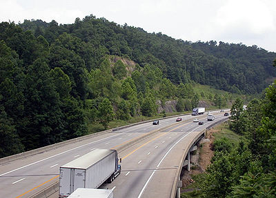
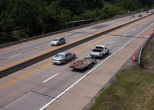
Historically, the West Virginia Turnpike was a two-lane road with treacherous curves and a tunnel
Tunnel
A tunnel is an underground passageway, completely enclosed except for openings for egress, commonly at each end.A tunnel may be for foot or vehicular road traffic, for rail traffic, or for a canal. Some tunnels are aqueducts to supply water for consumption or for hydroelectric stations or are sewers...
(which has since been decommissioned). Construction began in 1952, several years before the Eisenhower Interstate System was funded. It was only in 1986 that the entire length of the Turnpike was upgraded to Interstate standards.
The road is often referred to simply as "the Turnpike" by locals, since there are no other toll road
Toll road
A toll road is a privately or publicly built road for which a driver pays a toll for use. Structures for which tolls are charged include toll bridges and toll tunnels. Non-toll roads are financed using other sources of revenue, most typically fuel tax or general tax funds...
s in the state. Due to the difficulty and lives lost in construction, it has also been called "88 miles of miracle."
History
In the antebellum years before West Virginia separated from Virginia, development of adequate roads was a major area of conflict between the western regions and the east. Through the Board of Public WorksVirginia Board of Public Works
The Virginia Board of Public Works was a governmental agency which oversaw and helped finance the development of Virginia's internal transportation improvements during the 19th century. In that era, it was customary to invest public funds in private companies, which were the forerunners of the...
, the Virginia state government helped finance turnpikes among its programs to encourage internal improvements, with tolls collected to defray operating costs and retire debt. Principal among these was the east-west Staunton and Parkersburg Turnpike
Staunton and Parkersburg Turnpike
The Staunton and Parkersburg Turnpike was built in the U.S. state of the Commonwealth of Virginia during the second quarter of the 19th century to provide a roadway from Staunton and the upper Shenandoah Valley to the Ohio River at present-day Parkersburg...
, completed from Staunton
Staunton, Virginia
Staunton is an independent city within the confines of Augusta County in the commonwealth of Virginia. The population was 23,746 as of 2010. It is the county seat of Augusta County....
to the Ohio River
Ohio River
The Ohio River is the largest tributary, by volume, of the Mississippi River. At the confluence, the Ohio is even bigger than the Mississippi and, thus, is hydrologically the main stream of the whole river system, including the Allegheny River further upstream...
at Parkersburg
Parkersburg, West Virginia
As of the census of 2000, there were 33,099 people, 14,467 households, and 8,767 families residing in the city. In 2006 the U.S. Census Bureau estimated that Parkersburg's population had decreased 4.4% to 31,755. The population density was 2,800.5 people per square mile . There were 16,100 housing...
immediately prior to the American Civil War
American Civil War
The American Civil War was a civil war fought in the United States of America. In response to the election of Abraham Lincoln as President of the United States, 11 southern slave states declared their secession from the United States and formed the Confederate States of America ; the other 25...
(1861–1865). However, many of the internal transportation improvements were destroyed during that conflict, although bonded debt remained to be paid, even as additional progress had ended. After resolution by the U.S. Supreme Court, which assigned 1/3 of the amount due to the new state early in the 20th century, West Virginia was faced with retiring its share of Virginia's pre-civil war debt for the earlier turnpikes (and canals and railroads) even as the citizens needed and sought better roads.
With the completion of the earliest portion of the Pennsylvania Turnpike
Pennsylvania Turnpike
The Pennsylvania Turnpike is a toll highway system operated by the Pennsylvania Turnpike Commission in the Commonwealth of Pennsylvania, United States. The three sections of the turnpike system total . The main section extends from Ohio to New Jersey and is long...
before World War II
World War II
World War II, or the Second World War , was a global conflict lasting from 1939 to 1945, involving most of the world's nations—including all of the great powers—eventually forming two opposing military alliances: the Allies and the Axis...
by its northern neighbor, dreams in the Mountain State for such a "superhighway" took substantial root. By mid century, in the years before creation of the U.S. Interstate Highway System
Interstate Highway System
The Dwight D. Eisenhower National System of Interstate and Defense Highways, , is a network of limited-access roads including freeways, highways, and expressways forming part of the National Highway System of the United States of America...
in 1956, superhighways in the form of additional toll road
Toll road
A toll road is a privately or publicly built road for which a driver pays a toll for use. Structures for which tolls are charged include toll bridges and toll tunnels. Non-toll roads are financed using other sources of revenue, most typically fuel tax or general tax funds...
s such as the New Jersey Turnpike
New Jersey Turnpike
The New Jersey Turnpike is a toll road in New Jersey, maintained by the New Jersey Turnpike Authority. According to the International Bridge, Tunnel and Turnpike Association, the Turnpike is the nation's sixth-busiest toll road and is among one of the most heavily traveled highways in the United...
and the Ohio Turnpike
Ohio Turnpike
The Ohio Turnpike, officially the James W. Shocknessy Ohio Turnpike, is a -long, limited-access toll highway in the U.S. state of Ohio, serving as a primary corridor to Chicago and Pittsburgh...
began stimulating economic development and enhancing transportation in the eastern United States.
The challenge of terrain in West Virginia mirrored that of Pennsylvania in some ways, but with several important distinctions. Most important of these was that the first portion of the Pennsylvania Turnpike had largely followed and utilized a costly earlier rail project which had never been completed
South Pennsylvania Railroad
The South Pennsylvania Railroad is the name given to two proposed but never completed Pennsylvania railroads in the nineteenth-century. Parts of the right of way for the second South Pennsylvania Railroad were reused for the Pennsylvania Turnpike....
. In West Virginia, there would be no such advantage.
"Turnpike that goes to nowhere."
Transportation has always been a vital link between the main southern and central cities of West Virginia. Originally serviced by railroads and then two-lane highways, by the mid 20th century the cities grew to the point where the roadways between these regions were becoming woefully inadequate. Heavier traffic loads and increasing traffic volumes made the existing roads dangerous with safety statistics to prove it. In 1949, Governor Okey L. PattesonOkey L. Patteson
Okey Leonidas Patteson was born in Mingo County, West Virginia. He was the 23rd Governor of West Virginia for the term following the 1948 election...
oversaw the creation of The Turnpike Commission which was the start of the planning of what was to become the West Virginia Turnpike.
Two years earlier, the state legislature had appropriated funds to study the feasibility of building a superhighway comparable to similar projects being planned and constructed in other states. Early proposals showed a highway stretching from Parkersburg
Parkersburg, West Virginia
As of the census of 2000, there were 33,099 people, 14,467 households, and 8,767 families residing in the city. In 2006 the U.S. Census Bureau estimated that Parkersburg's population had decreased 4.4% to 31,755. The population density was 2,800.5 people per square mile . There were 16,100 housing...
to Princeton
Princeton, West Virginia
Princeton is a city in Mercer County, West Virginia, United States. The population was 7,652 at the 2000 census. It is part of the Bluefield, WV-VA micropolitan area which has a population of 111,586. It is the county seat of Mercer County...
, while another map diagrammed a route from Wheeling
Wheeling, West Virginia
Wheeling is a city in Ohio and Marshall counties in the U.S. state of West Virginia; it is the county seat of Ohio County. Wheeling is the principal city of the Wheeling Metropolitan Statistical Area...
to Princeton
Princeton, West Virginia
Princeton is a city in Mercer County, West Virginia, United States. The population was 7,652 at the 2000 census. It is part of the Bluefield, WV-VA micropolitan area which has a population of 111,586. It is the county seat of Mercer County...
. Both of these plans, however, were shelved in a 1951 study, citing the extreme costs of building a modern highway through very unforgiving terrain as the primary reason. The study recommended that the northern terminus be moved to Fairplain
Fairplain, West Virginia
Fairplain is an unincorporated community in Jackson County, West Virginia, United States. Fairplain is located along Interstate 77 south-southeast of Ripley....
just outside of Ripley
Ripley, West Virginia
Ripley is a city in and the county seat of Jackson County, West Virginia, United States.-Geography:Ripley is located at , along Mill Creek....
and that the southern terminus remain in Princeton. The study also suggested that the highway be constructed as a two-lane facility rather than a four-lane highway, with provisions for future widening when funding became available.
In November 1951, the final alignment was chosen. The route was 22 miles (35.4 km) shorter than the original road mileage between Charleston
Charleston, West Virginia
Charleston is the capital and largest city of the U.S. state of West Virginia. It is located at the confluence of the Elk and Kanawha Rivers in Kanawha County. As of the 2010 census, it has a population of 51,400, and its metropolitan area 304,214. It is the county seat of Kanawha County.Early...
and Princeton
Princeton, West Virginia
Princeton is a city in Mercer County, West Virginia, United States. The population was 7,652 at the 2000 census. It is part of the Bluefield, WV-VA micropolitan area which has a population of 111,586. It is the county seat of Mercer County...
, but would save motorists over two hours of driving between those two points. Original cost projections came in at $78 million. According to the West Virginia Turnpike CAF Report:
- "The Commission issued $96 million of 3-3/4% revenue bonds in April 1952, and groundbreaking took place in August of that year. Due to the occurrence of large slides midway through construction that had to be corrected at additional expense, revenue bonds for an additional $37 million were sold at 4-1/8%. The year 1953 kicked off a period of intense earthmoving that at its peak reached a million cubic yards a week and totaled 30000000 cubic yards (22,936,645.7 m³)."
When ground was broken on the first segment of the Turnpike in 1952, the northern terminus had once again been moved south. This time it was placed at Charleston
Charleston, West Virginia
Charleston is the capital and largest city of the U.S. state of West Virginia. It is located at the confluence of the Elk and Kanawha Rivers in Kanawha County. As of the 2010 census, it has a population of 51,400, and its metropolitan area 304,214. It is the county seat of Kanawha County.Early...
, citing cost as the primary reason. Cost was projected to be $133 million, to be funded through bonds that would be repaid through a system of tolls. This cost included $5 million for a two-lane tunnel to connect Dawes
Dawes, West Virginia
Dawes is an unincorporated community in Kanawha County, West Virginia, United States. Dawes is south of East Bank. Dawes has a post office with ZIP code 25054....
to Standard
Standard, West Virginia
Standard is an unincorporated community in Kanawha County, West Virginia, United States. The community is located on the West Virginia Turnpike north of the Fayette County line....
.
Construction took two years at the cost of five workers. The first section of the highway, the southern 36 miles (57.9 km) from Beckley
Beckley, West Virginia
Beckley is a city in Raleigh County, West Virginia, United States, which was founded on April 4, 1838. The 2008 population was estimated to be 16,832 by the U.S. Census Bureau. Early in its history, the town was known as Beckleyville and Raleigh Court House...
to Princeton
Princeton, West Virginia
Princeton is a city in Mercer County, West Virginia, United States. The population was 7,652 at the 2000 census. It is part of the Bluefield, WV-VA micropolitan area which has a population of 111,586. It is the county seat of Mercer County...
, opened to traffic on September 2, 1954. In November, the remaining 52 miles (83.7 km) between Charleston
Charleston, West Virginia
Charleston is the capital and largest city of the U.S. state of West Virginia. It is located at the confluence of the Elk and Kanawha Rivers in Kanawha County. As of the 2010 census, it has a population of 51,400, and its metropolitan area 304,214. It is the county seat of Kanawha County.Early...
and Beckley
Beckley, West Virginia
Beckley is a city in Raleigh County, West Virginia, United States, which was founded on April 4, 1838. The 2008 population was estimated to be 16,832 by the U.S. Census Bureau. Early in its history, the town was known as Beckleyville and Raleigh Court House...
opened. The new Turnpike had several nicknames, including "88 miles of miracle" and "the engineering marvel that beat the mountains." Five sided Turnpike shields were installed along the highway. Six interchanges were constructed. Initially, the road used a ticket-based tolling system. At each interchange, bridges and underpasses for the mainline had an extra set of graded lanes, indicating that the Turnpike was expected to be widened in the future. According to the West Virginia Turnpike CAF Report:
- "The $1.5 million cost per mile was only one of the staggering statistics used by journalists as far away as Michigan and New York to describe their 'amazement at an engineering achievement of such heroic proportions.' "
Three service areas, each served by an at-grade intersection, were constructed at Morton, Bluestone and Beckley
Beckley, West Virginia
Beckley is a city in Raleigh County, West Virginia, United States, which was founded on April 4, 1838. The 2008 population was estimated to be 16,832 by the U.S. Census Bureau. Early in its history, the town was known as Beckleyville and Raleigh Court House...
. The service areas were originally referred to as "Glass Houses."
For the first few years, the West Virginia Turnpike was a desolate roadway. Although the northern terminus was at a large city, it connected to no other interstates or free-flowing roads. The highway lost some of its "marvel" when The Saturday Evening Post
The Saturday Evening Post
The Saturday Evening Post is a bimonthly American magazine. It was published weekly under this title from 1897 until 1969, and quarterly and then bimonthly from 1971.-History:...
referred to the road as "the Turnpike that goes to nowhere."
Soon after the Turnpike was completed, the Interstate Highway System
Interstate Highway System
The Dwight D. Eisenhower National System of Interstate and Defense Highways, , is a network of limited-access roads including freeways, highways, and expressways forming part of the National Highway System of the United States of America...
began. The new Turnpike, despite its lack of compliance with interstate standards, cut travel time considerably through the state of West Virginia
West Virginia
West Virginia is a state in the Appalachian and Southeastern regions of the United States, bordered by Virginia to the southeast, Kentucky to the southwest, Ohio to the northwest, Pennsylvania to the northeast and Maryland to the east...
and linked the southern states to the northern states. This new link, however, was overloaded with traffic by the late 1960s. Increased accident rates resulted in large numbers of fatalities. By 1975, 278 people had died on the road. In 1979 alone, nearly 30 were killed. The Turnpike became known as a death-trap, mainly because out-of-state drivers who were accustomed to driving four-lane highways with wide medians and gentle curves were faced with a two-lane undivided freeway.
Popular t-shirts proclaimed, "I survived the West Virginia Turnpike."
Modernizing the Turnpike
Interstate Highway System
The Dwight D. Eisenhower National System of Interstate and Defense Highways, , is a network of limited-access roads including freeways, highways, and expressways forming part of the National Highway System of the United States of America...
brought in toll-free segments of newly-built Interstate 77
Interstate 77
Interstate 77 is an Interstate Highway in the eastern United States. It traverses diverse terrain, from the mountainous state of West Virginia to the rolling farmlands of North Carolina and Ohio. It largely supplants the old U.S...
from Ohio
Ohio
Ohio is a Midwestern state in the United States. The 34th largest state by area in the U.S.,it is the 7th‑most populous with over 11.5 million residents, containing several major American cities and seven metropolitan areas with populations of 500,000 or more.The state's capital is Columbus...
to the north, and Virginia
Virginia
The Commonwealth of Virginia , is a U.S. state on the Atlantic Coast of the Southern United States. Virginia is nicknamed the "Old Dominion" and sometimes the "Mother of Presidents" after the eight U.S. presidents born there...
to the south ends of the Turnpike. Interstate 64
Interstate 64
Interstate 64 is an Interstate Highway in the Midwestern and Southeastern United States. Its western terminus is at I-70, U.S. 40, and U.S. 61 in Wentzville, Missouri. Its eastern terminus is at an interchange with I-264 and I-664 at Bowers Hill in Chesapeake, Virginia. As I-64 is concurrent with...
was completed from the Kentucky
Kentucky
The Commonwealth of Kentucky is a state located in the East Central United States of America. As classified by the United States Census Bureau, Kentucky is a Southern state, more specifically in the East South Central region. Kentucky is one of four U.S. states constituted as a commonwealth...
border east to Charleston. Work on Interstate 79
Interstate 79
Interstate 79 is an Interstate Highway in the eastern United States, designated from Interstate 77 in Charleston, West Virginia to Pennsylvania Route 5 and Pennsylvania Route 290 in Erie, Pennsylvania...
extended south from Pennsylvania
Pennsylvania
The Commonwealth of Pennsylvania is a U.S. state that is located in the Northeastern and Mid-Atlantic regions of the United States. The state borders Delaware and Maryland to the south, West Virginia to the southwest, Ohio to the west, New York and Ontario, Canada, to the north, and New Jersey to...
through Morgantown
Morgantown, West Virginia
Morgantown is a city in Monongalia County, West Virginia. It is the county seat of Monongalia County. Placed along the banks of the Monongahela River, Morgantown is the largest city in North-Central West Virginia, and the base of the Morgantown metropolitan area...
and Clarksburg
Clarksburg, West Virginia
Clarksburg is a city in and the county seat of Harrison County, West Virginia, United States, in the north-central region of the state. It is the principal city of the Clarksburg, WV Micropolitan Statistical Area...
to Charleston. Another portion of Interstate 64 was built from Virginia west into the southern portion of the state, ending abruptly at Sam Black Church
Sam Black Church, West Virginia
Sam Black Church is an unincorporated community in Greenbrier County, West Virginia, United States. It is located at the intersection of Interstate 64 and U.S. Highway 60 on the Midland Trail, a National Scenic Byway. The community is named for Sam Black Church, a Registered Historic Place which is...
.
These connections brought more traffic to West Virginia
West Virginia
West Virginia is a state in the Appalachian and Southeastern regions of the United States, bordered by Virginia to the southeast, Kentucky to the southwest, Ohio to the northwest, Pennsylvania to the northeast and Maryland to the east...
than the 2-lane Turnpike could handle adequately. Congestion at the toll plazas was a major concern, along with the increased fatality rate.
The gap on Interstate 64 between Sam Black Church
Sam Black Church, West Virginia
Sam Black Church is an unincorporated community in Greenbrier County, West Virginia, United States. It is located at the intersection of Interstate 64 and U.S. Highway 60 on the Midland Trail, a National Scenic Byway. The community is named for Sam Black Church, a Registered Historic Place which is...
and Charleston
Charleston, West Virginia
Charleston is the capital and largest city of the U.S. state of West Virginia. It is located at the confluence of the Elk and Kanawha Rivers in Kanawha County. As of the 2010 census, it has a population of 51,400, and its metropolitan area 304,214. It is the county seat of Kanawha County.Early...
forced east–west traffic to use a scenic but treacherous section of U.S. Highway 60 known as the Midland Trail
Midland Trail (West Virginia)
The Midland Trail is a National Scenic Byway which carries U.S. Highway 60 through a portion of Southern West Virginia between Charleston and Sam Black Church...
through Rainelle
Rainelle, West Virginia
Rainelle is a town in Greenbrier County, West Virginia, United States. The population was 1,545 at the 2000 census.-History:Rainelle was named for the Raine family. Thomas and his brother John Raine moved there from Pennsylvania in 1906 to exploit one of the last large stands of virgin hardwoods in...
and Ansted
Ansted, West Virginia
Ansted is a town in Fayette County in the U.S. state of West Virginia. It is situated on high bluffs along U.S. Highway 60 on a portion of the Midland Trail a National Scenic Byway near Hawk's Nest overlooking the New River far below....
before the road descended Gauley Mountain at Hawk's Nest to the Kanawha River
Kanawha River
The Kanawha River is a tributary of the Ohio River, approximately 97 mi long, in the U.S. state of West Virginia. The largest inland waterway in West Virginia, it has formed a significant industrial region of the state since the middle of the 19th century.It is formed at the town of Gauley...
Valley to reach Charleston. There were terrible accidents along this stretch and lengthy delays as trucks negotiated the major grades.
Expansion
Studies were undertaken to upgrade the highway in the early-1970s. In 1974, the cost to expand the Turnpike to four-lanes was placed at $350 million. When the project had not started by 1975, articles in local newspapers attacked the state workers for their "laziness" in pursuing the upgrade of the highway. Turnpike officials worried, as the costs for upgrading the toll road were increasing dramatically.In 1976, contracts totaling well over $200 million were awarded, and construction began. A construction time-line follows:
- 1979: First section of modernization completed in Mercer CountyMercer County, West Virginia-External links:* * * * * * *...
from milepost 10.60 (just north of Exit 9, US 460) to milepost 35.52 (south of Exit 40, Interstate 64Interstate 64Interstate 64 is an Interstate Highway in the Midwestern and Southeastern United States. Its western terminus is at I-70, U.S. 40, and U.S. 61 in Wentzville, Missouri. Its eastern terminus is at an interchange with I-264 and I-664 at Bowers Hill in Chesapeake, Virginia. As I-64 is concurrent with...
) in Raleigh CountyRaleigh County, West VirginiaAs of the census of 2000, there were 79,220 people, 31,793 households, and 22,096 families residing in the county. The population density was 130 people per square mile . There were 35,678 housing units at an average density of 59 per square mile...
. - 1980: A segment from milepost 46.70 to milepost 47.95 (Exit 48, To US 19) was completed just north of BeckleyBeckley, West VirginiaBeckley is a city in Raleigh County, West Virginia, United States, which was founded on April 4, 1838. The 2008 population was estimated to be 16,832 by the U.S. Census Bureau. Early in its history, the town was known as Beckleyville and Raleigh Court House...
. - 1981: Fayette CountyFayette County, West VirginiaAs of the census of 2000, there were 47,579 people, 18,945 households, and 13,128 families residing in the county. The population density was 72 people per square mile . There were 21,616 housing units at an average density of 33 per square mile...
completed a brief segment from milepost 56.15 near Long Branch to milepost 59.63 (Exit 60, MossyMossy, West VirginiaMossy is an unincorporated community in Fayette County, West Virginia, United States. Mossy is located off exit 60 on the West Virginia Turnpike and is west of Oak Hill. As of 1993, the community had an Exxon gas station, a motel, and a restaurant, all owned by Teddy Gray or his relatives....
) and from milepost 62.27 near KingstonKingston, West VirginiaKingston is an unincorporated community in Fayette County, West Virginia, United States. Kingston is west of Oak Hill....
to milepost 66.51 (Exit 66, MahanMahan, West VirginiaMahan is an unincorporated community in Fayette County, West Virginia, United States. Mahan is located off exit 66 on the West Virginia Turnpike....
). - 1982: The modernization of the Turnpike from milepost 52.20 just south of Willis Branch to milepost 56.12 near Lively was completed. A second Kanawha RiverKanawha RiverThe Kanawha River is a tributary of the Ohio River, approximately 97 mi long, in the U.S. state of West Virginia. The largest inland waterway in West Virginia, it has formed a significant industrial region of the state since the middle of the 19th century.It is formed at the town of Gauley...
Bridge near MaldenMalden, West VirginiaMalden is an unincorporated community in Kanawha County, West Virginia, United States, within the Charleston metro area. The ZIP code for Malden is 25306 and the area code is 304. Malden is set in the Eastern Standard Time Zone.-History:...
and the Kanawha City neighborhood of Charleston was built to carry an additional two lanes of traffic between mileposts 94.96 to 95.87). - This four-lane upgrade was extended southward to milepost 90 (Exit 89, WV 94West Virginia State Route 94West Virginia Route 94 is a long north–south route connecting Marmet and Racine in West Virginia. The southern terminus of the route is at West Virginia Route 3 in Racine. The northern terminus is at West Virginia Route 61 in Marmet....
, MarmetMarmet, West VirginiaMarmet is a city in Kanawha County, West Virginia, USA, along the Kanawha River.-Geography:Marmet is located at .According to the United States Census Bureau, the city has a total area of 1.5 square miles , of which, 1.4 square miles of it is land and 0.1 square miles of it is...
) in 1984. - 1983: A segment between FayetteFayette County, West VirginiaAs of the census of 2000, there were 47,579 people, 18,945 households, and 13,128 families residing in the county. The population density was 72 people per square mile . There were 21,616 housing units at an average density of 33 per square mile...
and Kanawha CountiesKanawha County, West VirginiaAs of the census of 2000, there were 200,073 people, 86,226 households, and 55,960 families residing in the county. The population density was 222 people per square mile . There were 93,788 housing units at an average density of 104 per square mile...
was dualized from milepost 66.51 (Exit 66, MahanMahan, West VirginiaMahan is an unincorporated community in Fayette County, West Virginia, United States. Mahan is located off exit 66 on the West Virginia Turnpike....
) to milepost 74.96 (Exit 74, StandardStandard, West VirginiaStandard is an unincorporated community in Kanawha County, West Virginia, United States. The community is located on the West Virginia Turnpike north of the Fayette County line....
). Traffic just to the west of this interchange used the two-lane Bender Bridge and Memorial TunnelMemorial TunnelThe Memorial Tunnel is a two-lane vehicular tunnel that formerly carried the West Virginia Turnpike through/under Paint Creek Mountain in Standard, West Virginia in Kanawha County...
. - 1984: The Turnpike was dualized from milepost 90 (Exit 89, WV 94West Virginia State Route 94West Virginia Route 94 is a long north–south route connecting Marmet and Racine in West Virginia. The southern terminus of the route is at West Virginia Route 3 in Racine. The northern terminus is at West Virginia Route 61 in Marmet....
, MarmetMarmet, West VirginiaMarmet is a city in Kanawha County, West Virginia, USA, along the Kanawha River.-Geography:Marmet is located at .According to the United States Census Bureau, the city has a total area of 1.5 square miles , of which, 1.4 square miles of it is land and 0.1 square miles of it is...
) to milepost 82.55, including construction of a new Toll Plaza "C" near SharonSharon, West VirginiaSharon is an unincorporated community in southeastern Kanawha County, West Virginia, United States, located along the West Virginia Turnpike.-Geography:Sharon is located at . Its elevation is 673 feet .-Transportation:...
. - 1985: Work continues on a segment south of MossyMossy, West VirginiaMossy is an unincorporated community in Fayette County, West Virginia, United States. Mossy is located off exit 60 on the West Virginia Turnpike and is west of Oak Hill. As of 1993, the community had an Exxon gas station, a motel, and a restaurant, all owned by Teddy Gray or his relatives....
from milepost 59.63 (Exit 60, MossyMossy, West VirginiaMossy is an unincorporated community in Fayette County, West Virginia, United States. Mossy is located off exit 60 on the West Virginia Turnpike and is west of Oak Hill. As of 1993, the community had an Exxon gas station, a motel, and a restaurant, all owned by Teddy Gray or his relatives....
) to milepost 62.27 near KingstonKingston, West VirginiaKingston is an unincorporated community in Fayette County, West Virginia, United States. Kingston is west of Oak Hill....
. Also, a segment from the southern terminus of the Turnpike at milepost 8.97 (Exit 9, US 460) to milepost 10.60 in Mercer CountyMercer County, West Virginia-External links:* * * * * * *...
was reconstructed. A Raleigh CountyRaleigh County, West VirginiaAs of the census of 2000, there were 79,220 people, 31,793 households, and 22,096 families residing in the county. The population density was 130 people per square mile . There were 35,678 housing units at an average density of 59 per square mile...
segment from milepost 40.73 (Exit 40, Interstate 64Interstate 64Interstate 64 is an Interstate Highway in the Midwestern and Southeastern United States. Its western terminus is at I-70, U.S. 40, and U.S. 61 in Wentzville, Missouri. Its eastern terminus is at an interchange with I-264 and I-664 at Bowers Hill in Chesapeake, Virginia. As I-64 is concurrent with...
) to milepost 43.83 (Exit 44, WV 3West Virginia State Route 3West Virginia Route 3 is a state highway in the U.S. state of West Virginia. It runs from West Virginia Route 10 in West Hamlin in a general easterly direction via Beckley to West Virginia Route 311 at Sweet Springs, most of the way across the state....
) was dualized. The segment from milepost 47.95 (Exit 48, To US 19) to milepost 52.20 (Toll Plaza "B" at PaxPax, West VirginiaPax is a town in Fayette County, West Virginia, United States. The population was 174 at the 2000 census.-Geography:Pax is located at ....
) was completed. - 1986: The segment from milepost 35.52 to milepost 40.73 (Exit 40, Interstate 64Interstate 64Interstate 64 is an Interstate Highway in the Midwestern and Southeastern United States. Its western terminus is at I-70, U.S. 40, and U.S. 61 in Wentzville, Missouri. Its eastern terminus is at an interchange with I-264 and I-664 at Bowers Hill in Chesapeake, Virginia. As I-64 is concurrent with...
) was dualized. - 1987: Work finished the dualization from milepost 43.83 (Exit 44, WV 3West Virginia State Route 3West Virginia Route 3 is a state highway in the U.S. state of West Virginia. It runs from West Virginia Route 10 in West Hamlin in a general easterly direction via Beckley to West Virginia Route 311 at Sweet Springs, most of the way across the state....
) to milepost 46.60). The last segment was completed when the Memorial TunnelMemorial TunnelThe Memorial Tunnel is a two-lane vehicular tunnel that formerly carried the West Virginia Turnpike through/under Paint Creek Mountain in Standard, West Virginia in Kanawha County...
and Bender Bridge were bypassed with a massive road cut.
Bypassing Memorial Tunnel
By 1987, upgrading of 87 of the 88 miles (141.6 km) of the Turnpike were essentially completed. The only remaining segment, the Memorial TunnelMemorial Tunnel
The Memorial Tunnel is a two-lane vehicular tunnel that formerly carried the West Virginia Turnpike through/under Paint Creek Mountain in Standard, West Virginia in Kanawha County...
, once hailed as "state-of-the-art" and the "most majestic feature of the highway," was becoming a bottleneck in the otherwise four-lane highway. By 1986, the Turnpike Commission was spending over $500,000 per year to maintain the lights and the automatic exhaust equipment in the tunnel.
Several options were considered, including dualization of the tunnels, addition of two lanes through a large road cut in the mountain, leaving the other two lanes in the tunnel, and replacement of the entire tunnel with an open cut to the north. Citing the high maintenance costs of a tunnel, the replacement option was ultimately chosen.
- "The biggest relief will be from our utility crews, who had to maintain the electrical systems and so forth in the tunnel," Turnpike Commission Chairman George McIntryre said. "It will make all of our jobs easier as far as traffic is concerned on the turnpike."
The 1.72 miles (2.8 km) bypass would bypass both the tunnel and the Bender Bridge which crossed Paint Creek just to the east of the tunnel portal. On July 6, 1987, the Memorial Tunnel
Memorial Tunnel
The Memorial Tunnel is a two-lane vehicular tunnel that formerly carried the West Virginia Turnpike through/under Paint Creek Mountain in Standard, West Virginia in Kanawha County...
officially closed, and two lanes of the open cut just to the north of it were opened. The other two lanes of the open cut were completed in late August.
State Trooper W.D. Thomson became the last motorist to drive through the tunnel. It was not meant to be that way. Originally, Tommy Graley of Standard and his two daughters were picked to be in the last vehicle to pass through the tunnel, but his pickup truck was followed by a car carrying Turnpike officials and the state trooper.
The new Memorial Tunnel
Memorial Tunnel
The Memorial Tunnel is a two-lane vehicular tunnel that formerly carried the West Virginia Turnpike through/under Paint Creek Mountain in Standard, West Virginia in Kanawha County...
bypass cost $35 million and required years of work. Ten million cubic yards of earth were removed and used as fill with drainage tiles for Paint Creek. 300,000 tons of coal were extracted. The Bender Bridge was demolished. The former Memorial Tunnel
Memorial Tunnel
The Memorial Tunnel is a two-lane vehicular tunnel that formerly carried the West Virginia Turnpike through/under Paint Creek Mountain in Standard, West Virginia in Kanawha County...
was used for storage until the mid-1990s, when it became a testing center for tunnel-fire suppression for Boston's Big Dig project.
The tunnel is still being used today by the National Response Center for military and other testing uses. The bypass was not the first of its kind on a toll road, as the Pennsylvania Turnpike
Pennsylvania Turnpike
The Pennsylvania Turnpike is a toll highway system operated by the Pennsylvania Turnpike Commission in the Commonwealth of Pennsylvania, United States. The three sections of the turnpike system total . The main section extends from Ohio to New Jersey and is long...
bypassed the Laurel Hill Tunnel
Laurel Hill Tunnel
Laurel Hill Tunnel is one of three original Pennsylvania Turnpike tunnels which were abandoned after two massive realignment projects.The Laurel Hill Tunnel was bored under the border between Westmoreland and Somerset Counties...
in 1964 in similar fashion, and later bypassed two more tunnels with a single stretch of highway
Abandoned Pennsylvania Turnpike
The Abandoned Pennsylvania Turnpike is the common name of a 13 mile stretch of the Pennsylvania Turnpike that was bypassed in 1968 when a modern stretch opened to ease traffic congestion in the tunnels. In this case, the Sideling Hill Tunnel and Rays Hill Tunnel were bypassed, as was one of the...
in 1968.
Final cost
Bluestone River
The Bluestone River is a tributary of the New River, 77 mi long, in southwestern Virginia and southern West Virginia in the United States. Via the New, Kanawha and Ohio Rivers, it is part of the watershed of the Mississippi River...
serves southbound motorists.
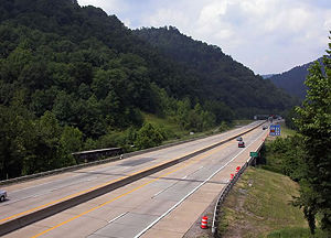
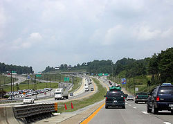
The Turnpike displays many cuts through mountains as well as lanes that are separated from each other by substantial difference in elevation. With the completion of Interstates 77, 79, and finally 64 by 1988, the Turnpike has again become stressed, especially during peak holiday seasons.
On June 1, 1989, The West Virginia Legislature created The West Virginia Parkways, Economic Development and Tourism Authority to replace the Turnpike Commission.
In 1991, the Morton and Bluestone "Glass Houses" were replaced with larger, more modern travel centers. In 1993, the Beckley Glass House was also replaced. Morton and Bluestone service plazas were available to northbound travelers only, while the Beckley service plaza was accessible only to southbound motorists.
In May 1996, Interchange 45 was renovated to serve the Beckley travel plaza, Dry Hill Road, and the newly constructed Tamarack
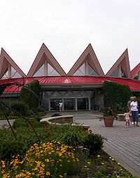
Tamarack, Best of West Virginia
Tamarack: The Best of West Virginia: is a tourist destination located at Exit 44 above the Beckley service area of the West Virginia Turnpike. It features a red peaked roof and landscaped grounds that draw over 500,000 visitors annually...
arts and crafts outlet.
In 2004, a concession stand and new restroom facilities were constructed at the rest area at milepost 69, serving southbound travelers.
Tamarack
Beckley, West Virginia
Beckley is a city in Raleigh County, West Virginia, United States, which was founded on April 4, 1838. The 2008 population was estimated to be 16,832 by the U.S. Census Bureau. Early in its history, the town was known as Beckleyville and Raleigh Court House...
service area, is an arts and crafts outlet that draws over 500,000 visitors a year. Tamarack features juried West Virginia craft products, including handcrafts, pottery, jewellery, fine arts, and products made from textiles, glass, metal, and wood. There are live artisan demonstrations as well as live music, a theater, and storytelling performances. It also contains a cafeteria-style restaurant.
Bond troubles
At one point in the Turnpike's history, the Turnpike Commission was not able to pay off even the interest on its bonded indebtedness, and the first bond was not retired until 1982. When the original bond expired on December 1, 1989, the Turnpike Commission had difficulty determining how to refinance it.Total revenues from 1954 through 1986 totaled $309.3 million, with interest of $170.7 million. In 1986, total annual revenues were $30.4 million. The Commission predicted that when Interstate 64 was completed from Beckley to Sam Black Church in 1988, 6,500 more vehicles would travel the Turnpike daily. In the previous 10 years, the Commission noted, traffic increased 100% and annual gross revenues increased from $11.4 million to $30.4 million.
The refinancing plan was ultimately completed about six months later, with a new debt approaching $50 million. Consequently, tolls were held at former rates, ranging from $3.75 to $12 per one-way through-trip.
Future of the Turnpike
Greg Barr, General Manager of the West Virginia Parkways Authority, has said that while other states have dramatically increased their tolls over the past few years, the West Virginia Turnpike has not experienced any rate hikes in over two decades. "
Turnpike today
Princeton, West Virginia
Princeton is a city in Mercer County, West Virginia, United States. The population was 7,652 at the 2000 census. It is part of the Bluefield, WV-VA micropolitan area which has a population of 111,586. It is the county seat of Mercer County...
, the turnpike travels a total of 88 miles (141.6 km). At first, the Turnpike parallels the Kanawha River
Kanawha River
The Kanawha River is a tributary of the Ohio River, approximately 97 mi long, in the U.S. state of West Virginia. The largest inland waterway in West Virginia, it has formed a significant industrial region of the state since the middle of the 19th century.It is formed at the town of Gauley...
and is mostly level. After Exit 85 (WV 61 to US 60, Chelyan/Cedar Grove), the road takes a sharp right turn and then arrives at the first tollbooth
Toll house
A tollhouse or toll house is a building with accommodation for a toll collector, beside a tollgate on a toll road or canal. Many tollhouses were built by turnpike trusts in England, Wales and Scotland during the 18th and early 19th centuries...
. Proceeding south, the Turnpike traverses rugged terrain and features several sharp curves and grades greater than 6%. The speed limit
Speed limit
Road speed limits are used in most countries to regulate the speed of road vehicles. Speed limits may define maximum , minimum or no speed limit and are normally indicated using a traffic sign...
of 60 mi/h is vigorously enforced by a toll-paid force of state police
West Virginia State Police
The West Virginia State Police is a paramilitary organization, state law enforcement agency in the United States that provides statewide police services to the 1.83 million residents in West Virginia...
. This stretch of the Turnpike has seen no greater accident rate than similar sections with higher speed limits, and in fact was signed at 65 mi/h from 1987 to 1995 with no change in its accident rate. The middle section of the Turnpike (roughly between Exits 60 and 28) mostly runs along ridge tops and more level areas near the city of Beckley, allowing for a 70 mi/h speed limit. The last segment (roughly from Exit 28 to Exit 9) has both mountainous and level sections, and retains the 70 mi/h speed limit. The Turnpike officially ends at Exit 9 (US 460, Princeton
Princeton, West Virginia
Princeton is a city in Mercer County, West Virginia, United States. The population was 7,652 at the 2000 census. It is part of the Bluefield, WV-VA micropolitan area which has a population of 111,586. It is the county seat of Mercer County...
/Pearisburg
Pearisburg, Virginia
Pearisburg is a town in Giles County, Virginia, United States. The population was 2,729 at the 2000 census. It is the county seat of Giles County.Pearisburg is part of the Blacksburg–Christiansburg–Radford Metropolitan Statistical Area....
). I-77 continues south from this point as a freeway, and crosses into Virginia
Virginia
The Commonwealth of Virginia , is a U.S. state on the Atlantic Coast of the Southern United States. Virginia is nicknamed the "Old Dominion" and sometimes the "Mother of Presidents" after the eight U.S. presidents born there...
through the East River Mountain Tunnel
East River Mountain Tunnel
The East River Mountain Tunnel is a vehicular tunnel that carries Interstate 77 and U.S. Route 52 through East River Mountain between the communities of Bluefield, West Virginia, and Rocky Gap, Virginia.-History:...
near Bluefield
Bluefield, West Virginia
Bluefield is a city in Mercer County, West Virginia, United States. The population was 10,447 at the 2010 census. It is also the core city of the Bluefield WV-VA micropolitan area which has a population of 107,342.-Geography & Climate:...
.
North of the Turnpike, I-77 continues as a freeway through northwestern West Virginia and exits the state across the Ohio River
Ohio River
The Ohio River is the largest tributary, by volume, of the Mississippi River. At the confluence, the Ohio is even bigger than the Mississippi and, thus, is hydrologically the main stream of the whole river system, including the Allegheny River further upstream...
near Parkersburg
Parkersburg, West Virginia
As of the census of 2000, there were 33,099 people, 14,467 households, and 8,767 families residing in the city. In 2006 the U.S. Census Bureau estimated that Parkersburg's population had decreased 4.4% to 31,755. The population density was 2,800.5 people per square mile . There were 16,100 housing...
.
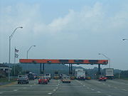
There are three toll booths along the Turnpike. As of August 2009, passenger cars pay $2.00 at each toll booth. Additionally, there is a toll booth at exit 48 (to US 19, North Beckley/Summersville
Summersville, West Virginia
Summersville is a town in Nicholas County, West Virginia, United States. The population was 3,194 at the 2000 census. It is the county seat of Nicholas County.-Geography:...
), which charges $0.40 for automobiles. Rates for larger vehicles are higher. The southernmost toll booth is south of the split with I-64, so east/west basic traffic pays $4.00. The West Virginia Turnpike is a member of the E-ZPass
E-ZPass
E-ZPass is an electronic toll-collection system used on most tolled roads, bridges, and tunnels in the northeastern US, south to Virginia and West Virginia, and west to Illinois. Currently, there are 25 agencies spread across 14 states that make up the . All member agencies use the same technology,...
electronic toll collection
Electronic toll collection
Electronic toll collection , an adaptation of military "identification friend or foe" technology, aims to eliminate the delay on toll roads by collecting tolls electronically. It is thus a technological implementation of a road pricing concept...
consortium, allowing members to use express lanes and pay electronically.
Exit list
|-|colspan=6 align=center|Route continues south as
.svg.png)
Interstate 77 in West Virginia
In the U.S. state of West Virginia, Interstate 77 is a major north–south Interstate highway. It extends for between Bluefield at the Virginia state line to Williamstown at the Ohio state line....
|-
|rowspan=5|Mercer
Mercer County, West Virginia
-External links:* * * * * * *...
|
|8.8
|9
|, Pearisburg
Pearisburg, Virginia
Pearisburg is a town in Giles County, Virginia, United States. The population was 2,729 at the 2000 census. It is the county seat of Giles County.Pearisburg is part of the Blacksburg–Christiansburg–Radford Metropolitan Statistical Area....
|
|-
|
|
|colspan=3 align=center| Princeton travel center
|-
|
|13.6
|14
|
|Added during reconstruction in 1979
|-
|
|
|colspan=3 align=center|Bluestone service plaza (northbound only)
|-
|
|19.6
|20
|
|Added during reconstruction in 1979
|-
|rowspan=8|Raleigh
Raleigh County, West Virginia
As of the census of 2000, there were 79,220 people, 31,793 households, and 22,096 families residing in the county. The population density was 130 people per square mile . There were 35,678 housing units at an average density of 59 per square mile...
|
|28.8
|28
|
|Added during reconstruction in 1979
|-
|
|
|colspan=3 align=center|Plaza A (Ghent) Toll booth
|-
|
|39.3
|40
|
|The interchange was constructed with provisions for a toll plaza; the exit itself was not utilized until 1988 when the interstate was completed east towards Lewisburg; begin Interstate 64 concurrency
|-
|
|41.8
|42
|
|An original interchange on the Turnpike; it is a double trumpet
|-
|
|44.3
|44
|
|An original interchange on the Turnpike; expanded from a trumpet with a toll plaza to a diamond with reconstruction of the mainlines in 1985
|-
|
|45.6
|colspan=3 align=center| Beckley service plaza
|-
|
|45.6
|45
|
|Beckley service plaza
Tamarack
Tamarack, Best of West Virginia
Tamarack: The Best of West Virginia: is a tourist destination located at Exit 44 above the Beckley service area of the West Virginia Turnpike. It features a red peaked roof and landscaped grounds that draw over 500,000 visitors annually...
. Added in the mid 1990s when the Beckley service plaza was expanded to include the Tamarack.
|-
|
|47.4
|48
|
|Toll booth at ramp for WVTPK NB to US 19 NB and for US 19 SB to WVTPK SB; added during reconstruction in 1980
|-
|rowspan=4|Fayette
Fayette County, West Virginia
As of the census of 2000, there were 47,579 people, 18,945 households, and 13,128 families residing in the county. The population density was 72 people per square mile . There were 21,616 housing units at an average density of 33 per square mile...
|
|54.4
|54
|
|Added during reconstruction in 1982
|-
|
|
|colspan=3 align=center|Plaza B (Pax) Toll booth
|-
|
|59.4
|60
|
|An original interchange on the Turnpike; full access during reconstruction in 1985; previously had northbound entrance, southbound exit only and contained a toll booth
|-
|
|66.0
|66
|
|Added during reconstruction in 1983
|-
|rowspan=10|Kanawha
Kanawha County, West Virginia
As of the census of 2000, there were 200,073 people, 86,226 households, and 55,960 families residing in the county. The population density was 222 people per square mile . There were 93,788 housing units at an average density of 104 per square mile...
|
|
|colspan=3 align=center|Rest area (southbound only)
|-
|
|74.0
|74
|
|Added during reconstruction in 1983
|-
|
|
|colspan=3 align=center|Morton service plaza (northbound only)
|-
|
|79.3
|79
|
|Added during reconstruction in 1981
|-
|
|
|colspan=3 align=center|Plaza C (Chelyan) Toll booth
|-
|
|84.5
|85
|
|An original interchange on the Turnpike; formerly contained a toll plaza
|-
|
|89.3
|89
|
|Added during reconstruction in 1981
|-
|
|94.3
|95
|
|An original interchange on the Turnpike; formerly contained a toll plaza within the double trumpet
|-
|Charleston
Charleston, West Virginia
Charleston is the capital and largest city of the U.S. state of West Virginia. It is located at the confluence of the Elk and Kanawha Rivers in Kanawha County. As of the 2010 census, it has a population of 51,400, and its metropolitan area 304,214. It is the county seat of Kanawha County.Early...
|95.5
|96
|
|Former trumpet interchange with toll plaza; modified after reconstruction in 1982
|-
|colspan=5 align=center|Route continues as westbound
.svg.png)
Interstate 64 in West Virginia
The alignment of Interstate 64 was to originally parallel US 60 from Charleston to the Virginia state line. This would go through environmentally sensitive areas such as Hawk's Nest and the New River Gorge area and might have disrupted the natural beauty and the isolation of the area.In 1969,...
and northbound
Interstate 77 in West Virginia
In the U.S. state of West Virginia, Interstate 77 is a major north–south Interstate highway. It extends for between Bluefield at the Virginia state line to Williamstown at the Ohio state line....
.