

U.S. Route 45
Encyclopedia
U.S. Route 45 is a north–south United States highway. US 45 is a border-to-border route, from Lake Superior
to the Gulf of Mexico
. A sign at the highway's northern terminus notes the total distance as 1300 miles (2,092.1 km).
US 45 is notable for incorporating, in its maiden alignment, the first paved road in the South, a 49-mile segment in Lee County, Mississippi. Let to contract in July 1914, the concrete highway opened on November 15, 1915.
As of 2006, the highway's northern terminus is in Ontonagon, Michigan
, at the corner of Ontonagon and River Streets, a few blocks from Lake Superior
. M-64
formerly terminated there as well until its rerouting in October 2006 to use the newly built Ontonagon River Bridge. Its southern terminus is in Mobile, Alabama
, at an intersection with U.S. Route 98
.
and Vinegar Bend in Washington County, Alabama
. From Vinegar Bend until the Mississippi
state line, U.S. 45 is paired with unsigned Alabama State Route 57.
 U.S. Highway 45 is part of a designated hurricane evacuation route in Mississippi. It is entirely four-laned from its point of entry from Alabama, at the town of State Line, to the Tennessee line just north of Corinth
, along the way serving the towns of (from south to north) Waynesboro
, Meridian
, Columbus
and Tupelo
.
At Brooksville, U.S. 45 splits away from U.S. 45 Alternate and serves the towns of Columbus
and Aberdeen
before rejoining U.S. 45 Alternate south of Tupelo
. The alternate roadway provides a more direct and entirely four-laned route between Meridian and Tupelo, bypassing Columbus to the west and, more closely, Starkville
to the east. The longer mainline route includes a segment of two-lane roadway immediately north of the split with 45-Alternate and continuing to US 82. Construction is presently underway to widen this entire segment, with final completion expected in September, 2012.
Major junctions of U.S. 45 in Mississippi include U.S. Route 84
at Waynesboro, Interstate 20
/59
at Meridian, U.S. Route 82
at Columbus, future Interstate 22
(present U.S. Route 78
) at Tupelo and U.S. Route 72
at Corinth. Each of these junctions is an interchange and, with the exception of Waynesboro, each is part of a freeway segment.
The Mississippi section of U.S. 45 is defined at Mississippi Code Annotated § 65-3-3.
 U.S. 45 and 45W are concurrent with unsigned Tennessee State Route 5
from the Mississippi state line to Union City
and then with U.S. 51 (unsigned SR 3) to the Kentucky
state line. U.S. 45E is concurrent with unsigned Tennessee State Route 43
for most of the route's length, except for short segments at Martin
and South Fulton
where it is cosigned with Tennessee State Route 216 and Tennessee State Route 215 respectively.
at exit 7, and intersecting US 60
and 62. U.S. 45 leaves Kentucky from Paducah's northern border across a two-lane, metal grate bridge into Illinois across the Ohio River
.
, through Shawnee National Forest
and north to the Wisconsin border east of Antioch, Illinois
. With a length of 428.99 miles (690.39 km) in Illinois, U.S. 45 is the longest numbered route in Illinois.
 U.S. 45 enters the state in southeast Wisconsin
. It runs concurrent with Interstate 894
and U.S. Route 41
through the west side of metro Milwaukee to form a major artery through the metropolitan area. It runs north to Fond du Lac
. The highway routes near the west coast of Lake Winnebago
through Oshkosh, Wisconsin
. U.S. 45 then travels north through the state and national forests until it exits the state and enters Michigan
at Land O' Lakes.
through the Ottawa National Forest
running north to Ontonagon
. US 45 ends just south of Lake Superior
in downtown Ontonagon. The terminus was not changed in 2006 despite realignment then of M-38
and M-64
from the terminus to a crossing 0.7 miles (1.1 km) south.
Prior to the construction of the Interstate Highway system, US 45 was one of the main routes south out of Chicago toward New Orleans
. Much of the traffic left US 45 at Effingham, Illinois
, continuing on through Cairo, Illinois
along Illinois Route 37
.
Lake Superior
Lake Superior is the largest of the five traditionally-demarcated Great Lakes of North America. It is bounded to the north by the Canadian province of Ontario and the U.S. state of Minnesota, and to the south by the U.S. states of Wisconsin and Michigan. It is the largest freshwater lake in the...
to the Gulf of Mexico
Gulf of Mexico
The Gulf of Mexico is a partially landlocked ocean basin largely surrounded by the North American continent and the island of Cuba. It is bounded on the northeast, north and northwest by the Gulf Coast of the United States, on the southwest and south by Mexico, and on the southeast by Cuba. In...
. A sign at the highway's northern terminus notes the total distance as 1300 miles (2,092.1 km).
US 45 is notable for incorporating, in its maiden alignment, the first paved road in the South, a 49-mile segment in Lee County, Mississippi. Let to contract in July 1914, the concrete highway opened on November 15, 1915.
As of 2006, the highway's northern terminus is in Ontonagon, Michigan
Ontonagon, Michigan
Ontonagon is a village in the U.S. state of Michigan. As of the 2000 census, the village had a total population of 1,769. It is the county seat of Ontonagon County....
, at the corner of Ontonagon and River Streets, a few blocks from Lake Superior
Lake Superior
Lake Superior is the largest of the five traditionally-demarcated Great Lakes of North America. It is bounded to the north by the Canadian province of Ontario and the U.S. state of Minnesota, and to the south by the U.S. states of Wisconsin and Michigan. It is the largest freshwater lake in the...
. M-64
M-64 (Michigan highway)
M-64 is a north–south state trunkline highway in the Upper Peninsula of the US state of Michigan. It runs for through the western part of the state in land that is part of the Ottawa National Forest. The highway connects with County Trunk Highway B at the state line near Presque Isle, Wisconsin....
formerly terminated there as well until its rerouting in October 2006 to use the newly built Ontonagon River Bridge. Its southern terminus is in Mobile, Alabama
Mobile, Alabama
Mobile is the third most populous city in the Southern US state of Alabama and is the county seat of Mobile County. It is located on the Mobile River and the central Gulf Coast of the United States. The population within the city limits was 195,111 during the 2010 census. It is the largest...
, at an intersection with U.S. Route 98
U.S. Route 98
U.S. Route 98 is an east–west United States highway that runs from western Mississippi to southern Florida. It was established in 1933 as a route between Pensacola, Florida and Apalachicola, Florida, and has since been extended westward into Mississippi and eastward across the Florida...
.
Alabama
U.S. 45 is co-routed with unsigned State Route 17 between MobileMobile, Alabama
Mobile is the third most populous city in the Southern US state of Alabama and is the county seat of Mobile County. It is located on the Mobile River and the central Gulf Coast of the United States. The population within the city limits was 195,111 during the 2010 census. It is the largest...
and Vinegar Bend in Washington County, Alabama
Alabama
Alabama is a state located in the southeastern region of the United States. It is bordered by Tennessee to the north, Georgia to the east, Florida and the Gulf of Mexico to the south, and Mississippi to the west. Alabama ranks 30th in total land area and ranks second in the size of its inland...
. From Vinegar Bend until the Mississippi
Mississippi
Mississippi is a U.S. state located in the Southern United States. Jackson is the state capital and largest city. The name of the state derives from the Mississippi River, which flows along its western boundary, whose name comes from the Ojibwe word misi-ziibi...
state line, U.S. 45 is paired with unsigned Alabama State Route 57.
Mississippi
Corinth, Mississippi
Corinth is a city in Alcorn County, Mississippi, United States. The population was 14,054 at the 2000 census. It is the county seat of Alcorn County. Its ZIP codes are 38834 and 38835.- History :...
, along the way serving the towns of (from south to north) Waynesboro
Waynesboro, Mississippi
Waynesboro is a city in Wayne County, Mississippi, United States. The population was 5,197 at the 2000 census. It is the county seat of Wayne County.-Geography:Waynesboro is located at , just east of the Chickasawhay River....
, Meridian
Meridian, Mississippi
Meridian is the county seat of Lauderdale County, Mississippi. It is the sixth largest city in the state and the principal city of the Meridian, Mississippi Micropolitan Statistical Area...
, Columbus
Columbus, Mississippi
Columbus is a city in Lowndes County, Mississippi, United States that lies above the Tombigbee River. It is approximately northeast of Jackson, north of Meridian, south of Tupelo, northwest of Tuscaloosa, Alabama, and west of Birmingham, Alabama. The population was 25,944 at the 2000 census...
and Tupelo
Tupelo, Mississippi
Tupelo is the largest city in and the county seat of Lee County, Mississippi, United States. It is the seventh largest city in the state of Mississippi, smaller than Meridian, and larger than Greenville. As of the 2000 United States Census, the city's population was 34,211...
.
At Brooksville, U.S. 45 splits away from U.S. 45 Alternate and serves the towns of Columbus
Columbus, Mississippi
Columbus is a city in Lowndes County, Mississippi, United States that lies above the Tombigbee River. It is approximately northeast of Jackson, north of Meridian, south of Tupelo, northwest of Tuscaloosa, Alabama, and west of Birmingham, Alabama. The population was 25,944 at the 2000 census...
and Aberdeen
Aberdeen, Mississippi
Aberdeen is a city in Monroe County in the U.S. state of Mississippi. The population was 6,415 at the 2000 census. It is the county seat of Monroe County....
before rejoining U.S. 45 Alternate south of Tupelo
Tupelo, Mississippi
Tupelo is the largest city in and the county seat of Lee County, Mississippi, United States. It is the seventh largest city in the state of Mississippi, smaller than Meridian, and larger than Greenville. As of the 2000 United States Census, the city's population was 34,211...
. The alternate roadway provides a more direct and entirely four-laned route between Meridian and Tupelo, bypassing Columbus to the west and, more closely, Starkville
Starkville, Mississippi
-Demographics:As of the census of 2000, there were 21,869 people, 9,462 households, and 4,721 families residing in the city. The population density was 851.4 people per square mile . There were 10,191 housing units at an average density of 396.7 per square mile...
to the east. The longer mainline route includes a segment of two-lane roadway immediately north of the split with 45-Alternate and continuing to US 82. Construction is presently underway to widen this entire segment, with final completion expected in September, 2012.
Major junctions of U.S. 45 in Mississippi include U.S. Route 84
U.S. Route 84
U.S. Route 84 is an east–west United States highway. It started as a short Georgia-Alabama route in the original 1926 scheme, but now extends all the way to Colorado. The highway's eastern terminus is a short distance east of Midway, Georgia, at an intersection with I-95. The road continues...
at Waynesboro, Interstate 20
Interstate 20
Interstate 20 is a major east–west Interstate Highway in the Southern United States. I‑20 runs 1,535 miles from near Kent, Texas, at Interstate 10 to Florence, South Carolina, at Interstate 95...
/59
Interstate 59
Interstate 59 is an Interstate Highway in the southern United States. Its southern terminus is near Slidell, Louisiana, a suburb of New Orleans, at an intersection with Interstate 10 and Interstate 12, its northern terminus is at Wildwood, Georgia, at an intersection with Interstate 24.The road's...
at Meridian, U.S. Route 82
U.S. Route 82
U.S. Route 82 is an east–west United States highway in the southern United States. What started as a 1932 addition to the system across central Mississippi and southern Arkansas eventually became a 1,609 mile route extending from the White Sands of New Mexico to Georgia's Atlantic coast.The...
at Columbus, future Interstate 22
Interstate 22
Interstate 22 , when it is completed, will follow the U.S. Highway 78 corridor along a 213-mile-long route from Memphis, Tennessee, to Birmingham, Alabama, as an Interstate Highway. Interstate 22 will connect Interstate 240 and Interstate 40 in the northwest with Interstate 65 and Interstate...
(present U.S. Route 78
U.S. Route 78
U.S. Highway 78 is an east–west United States highway that runs for 715 miles from Memphis, Tennessee, to Charleston, South Carolina. Between Memphis and Birmingham, Alabama, it is being upgraded to become Interstate 22....
) at Tupelo and U.S. Route 72
U.S. Route 72
U.S. Route 72 is an east–west United States highway that runs for 337 miles from southeast Tennessee through northern Alabama and northern Mississippi to southwest Tennessee. The highway's eastern terminus is Chattanooga, Tennessee. Its western terminus is Memphis, Tennessee...
at Corinth. Each of these junctions is an interchange and, with the exception of Waynesboro, each is part of a freeway segment.
The Mississippi section of U.S. 45 is defined at Mississippi Code Annotated § 65-3-3.
Tennessee
Tennessee State Route 5
State Route 5 is a major south–north highway in West Tennessee. SR 5 is long and, except for the section north of Union City, is overlapped with US 45 & 45W.-Route description:...
from the Mississippi state line to Union City
Union City, Tennessee
Union City is a city in Obion County, Tennessee, United States. The population was 10,876 at the 2000 census. It is the county seat of Obion County. The name comes from its location at the union of two railroads, one running roughly east-west and the other roughly north-south...
and then with U.S. 51 (unsigned SR 3) to the Kentucky
Kentucky
The Commonwealth of Kentucky is a state located in the East Central United States of America. As classified by the United States Census Bureau, Kentucky is a Southern state, more specifically in the East South Central region. Kentucky is one of four U.S. states constituted as a commonwealth...
state line. U.S. 45E is concurrent with unsigned Tennessee State Route 43
Tennessee State Route 43
State Route 43 is a south to north highway in Tennessee that is 56.79 miles long. It begins in Madison County and ends in Obion County. State Route 43 is little-known by the general public by this designation as it is overlain by U.S. Route 45E for most of its length; the "43" designation is seen...
for most of the route's length, except for short segments at Martin
Martin, Tennessee
Martin is a city in Weakley County, Tennessee, United States. Martin is the home of the University of Tennessee at Martin. The population was 10,515 at the 2000 census.-Geography:Martin is located at ....
and South Fulton
South Fulton, Tennessee
South Fulton is a city in Obion County, Tennessee, in the United States. The population was 2,517 at the 2000 census. It is part of the Union City, TN–KY Micropolitan Statistical Area.-Geography:South Fulton is located at ....
where it is cosigned with Tennessee State Route 216 and Tennessee State Route 215 respectively.
Kentucky
U.S. 45 enters Kentucky in Graves County, where it passes through Mayfield, KY and heads directly north into Paducah, KY as a four-lane highway. In Paducah, U.S. 45 serves as a major artery, intersecting with Interstate 24Interstate 24
Interstate 24 is an Interstate Highway in the Midwestern and Southeastern United States. It runs diagonally from Interstate 57 to Chattanooga, Tennessee, at Interstate 75....
at exit 7, and intersecting US 60
U.S. Route 60
U.S. Route 60 is an east–west United States highway, running from the Atlantic Ocean on the east coast in Virginia to western Arizona. Despite the final "0" in its number, indicating a transcontinental designation, the 1926 route formerly ended in Springfield, Missouri, at its intersection...
and 62. U.S. 45 leaves Kentucky from Paducah's northern border across a two-lane, metal grate bridge into Illinois across the Ohio River
Ohio River
The Ohio River is the largest tributary, by volume, of the Mississippi River. At the confluence, the Ohio is even bigger than the Mississippi and, thus, is hydrologically the main stream of the whole river system, including the Allegheny River further upstream...
.
Illinois
In the state of Illinois, U.S. 45 runs from the bridge across the Ohio River east of Paducah, KentuckyPaducah, Kentucky
Paducah is the largest city in Kentucky's Jackson Purchase Region and the county seat of McCracken County, Kentucky, United States. It is located at the confluence of the Tennessee River and the Ohio River, halfway between the metropolitan areas of St. Louis, Missouri, to the west and Nashville,...
, through Shawnee National Forest
Shawnee National Forest
The Shawnee National Forest, located in the Ozark and Shawnee Hills of Southern Illinois, consists of approximately 280,000 acres of federally managed lands. In descending order of land area it is located in parts of Pope, Jackson, Union, Hardin, Alexander, Saline, Gallatin, Johnson, and Massac...
and north to the Wisconsin border east of Antioch, Illinois
Antioch, Illinois
Antioch is a village in the Antioch Township of Lake County, Illinois, United States. The population was 14,430 at the 2010 census. Antioch is part of the Chicago metropolitan area.- Prior to incorporation :...
. With a length of 428.99 miles (690.39 km) in Illinois, U.S. 45 is the longest numbered route in Illinois.
Wisconsin
Wisconsin
Wisconsin is a U.S. state located in the north-central United States and is part of the Midwest. It is bordered by Minnesota to the west, Iowa to the southwest, Illinois to the south, Lake Michigan to the east, Michigan to the northeast, and Lake Superior to the north. Wisconsin's capital is...
. It runs concurrent with Interstate 894
Interstate 894
Interstate 894 is a auxiliary Interstate Highway in Milwaukee County in the US state of Wisconsin. The route serves as a bypass of downtown Milwaukee, connecting with I-94 at the Zoo Interchange west of downtown and the Mitchell Interchange south of downtown...
and U.S. Route 41
U.S. Route 41
U.S. Route 41 is a north–south United States Highway that runs from Miami, Florida to the Upper Peninsula of Michigan. Until 1949, the part in southern Florida, from Naples to Miami, was U.S...
through the west side of metro Milwaukee to form a major artery through the metropolitan area. It runs north to Fond du Lac
Fond du Lac, Wisconsin
Fond du Lac is a city in Fond du Lac County, Wisconsin, United States. The name is French for bottom of the lake, for it is located at the bottom of Lake Winnebago. The population was 42,203 at the 2000 census...
. The highway routes near the west coast of Lake Winnebago
Lake Winnebago
Lake Winnebago is a freshwater lake in eastern Wisconsin, United States. It is the largest lake entirely within the state.-Statistics:...
through Oshkosh, Wisconsin
Oshkosh, Wisconsin
As of the census of 2000, there were 62,916 people, 24,082 households, and 13,654 families residing in the city. The population density was 2,662.2 people per square mile . There were 25,420 housing units at an average density of 1,075.6 per square mile...
. U.S. 45 then travels north through the state and national forests until it exits the state and enters Michigan
Michigan
Michigan is a U.S. state located in the Great Lakes Region of the United States of America. The name Michigan is the French form of the Ojibwa word mishigamaa, meaning "large water" or "large lake"....
at Land O' Lakes.
Michigan
US 45 enters Michigan south of Watersmeet. From there, the highway crosses the Western Upper PeninsulaUpper Peninsula of Michigan
The Upper Peninsula of Michigan is the northern of the two major land masses that make up the U.S. state of Michigan. It is commonly referred to as the Upper Peninsula, the U.P., or Upper Michigan. It is also known as the land "above the Bridge" linking the two peninsulas. The peninsula is bounded...
through the Ottawa National Forest
Ottawa National Forest
The Ottawa National Forest is a 1.0 million acre national forest in the Upper Peninsula of the U.S. state of Michigan. It includes much of Gogebic and Ontonagon counties, as well as slices of Iron, Houghton, Baraga, and Marquette counties. The forest is under the jurisdiction of the U.S...
running north to Ontonagon
Ontonagon, Michigan
Ontonagon is a village in the U.S. state of Michigan. As of the 2000 census, the village had a total population of 1,769. It is the county seat of Ontonagon County....
. US 45 ends just south of Lake Superior
Lake Superior
Lake Superior is the largest of the five traditionally-demarcated Great Lakes of North America. It is bounded to the north by the Canadian province of Ontario and the U.S. state of Minnesota, and to the south by the U.S. states of Wisconsin and Michigan. It is the largest freshwater lake in the...
in downtown Ontonagon. The terminus was not changed in 2006 despite realignment then of M-38
M-38 (Michigan highway)
M-38 is an east–west state trunkline highway in the Upper Peninsula of the U.S. state of Michigan. Its west end starts in Ontonagon and runs east to Baraga, some apart. The highway crosses streams and rivers in forest lands and provides access to a casino...
and M-64
M-64 (Michigan highway)
M-64 is a north–south state trunkline highway in the Upper Peninsula of the US state of Michigan. It runs for through the western part of the state in land that is part of the Ottawa National Forest. The highway connects with County Trunk Highway B at the state line near Presque Isle, Wisconsin....
from the terminus to a crossing 0.7 miles (1.1 km) south.
Historic termini
Until 1934, US 45's northern terminus was in the Chicago, Illinois area.Prior to the construction of the Interstate Highway system, US 45 was one of the main routes south out of Chicago toward New Orleans
New Orleans, Louisiana
New Orleans is a major United States port and the largest city and metropolitan area in the state of Louisiana. The New Orleans metropolitan area has a population of 1,235,650 as of 2009, the 46th largest in the USA. The New Orleans – Metairie – Bogalusa combined statistical area has a population...
. Much of the traffic left US 45 at Effingham, Illinois
Effingham, Illinois
Effingham is a city in Effingham County, Illinois, United States. The population was 12,384 at the 2000 census. It is the county seat of Effingham County....
, continuing on through Cairo, Illinois
Cairo, Illinois
Cairo is the southernmost city in the U.S. state of Illinois. It is the county seat of Alexander County. Cairo is located at the confluence of the Mississippi and Ohio rivers. The rivers converge at Fort Defiance State Park, an American Civil War fort that was commanded by General Ulysses S. Grant...
along Illinois Route 37
Illinois Route 37
Illinois Route 37, or Illinois 37, is a north–south route in southern Illinois. It is in length. Originally connecting Effingham to Cairo, it was a heavily-traveled highway before Interstate 57 was opened. That Interstate, which lies very close to most of Illinois 37 , supplanted it as a...
.
Bannered and suffixed routes
- U.S. Route 45E
- U.S. Route 45W
- U.S. Route 45 Alternate in Tupelo, MississippiTupelo, MississippiTupelo is the largest city in and the county seat of Lee County, Mississippi, United States. It is the seventh largest city in the state of Mississippi, smaller than Meridian, and larger than Greenville. As of the 2000 United States Census, the city's population was 34,211...
- U.S. Route 45 Business in Wittenburg, Wisconsin
- U.S. Route 45 Business in New London, WisconsinNew London, WisconsinNew London is a city in Outagamie and Waupaca Counties in the U.S. state of Wisconsin. The population was 7,295 at the 2010 census. The city has a Saint Patrick's Day Parade, Irish Fest, and week-long festivities, when the city's name is changed to "New Dublin" for the week. The American Water...
- U.S. Route 45 Business in Paducah, KentuckyPaducah, KentuckyPaducah is the largest city in Kentucky's Jackson Purchase Region and the county seat of McCracken County, Kentucky, United States. It is located at the confluence of the Tennessee River and the Ohio River, halfway between the metropolitan areas of St. Louis, Missouri, to the west and Nashville,...
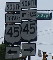
- U.S. Route 45 Bypass in Jackson, TennesseeJackson, TennesseeJackson is a city in Madison County, Tennessee, United States. The total population was 65,211 at the 2010 census. Jackson is the primary city of the Jackson, Tennessee metropolitan area, which is included in the Jackson-Humboldt, Tennessee Combined Statistical Area...
- U.S. Route 45W Business in Trenton, TennesseeTrenton, TennesseeTrenton is a city in Gibson County, Tennessee, United States. The population was 4,264 at the 2010 census. It is the county seat of Gibson County, and its third largest city.-Geography:Trenton is located at ....
Decommissioned and resigned as Tennessee State Route 367 - U.S. Route 45W Business in Humboldt, TennesseeHumboldt, TennesseeHumboldt is a city in Gibson and Madison counties in the U.S. state of Tennessee. The population was 8,452 at the 2010 census, a decline of 1,015 in 2000. It is the principal city of and is included in the Humboldt, Tennessee Micropolitan Statistical Area, which is included in the Jackson,...
- U.S. Route 45E Business in Martin, TennesseeMartin, TennesseeMartin is a city in Weakley County, Tennessee, United States. Martin is the home of the University of Tennessee at Martin. The population was 10,515 at the 2000 census.-Geography:Martin is located at ....
- U.S. Route 45 Business in Tupelo, MississippiTupelo, MississippiTupelo is the largest city in and the county seat of Lee County, Mississippi, United States. It is the seventh largest city in the state of Mississippi, smaller than Meridian, and larger than Greenville. As of the 2000 United States Census, the city's population was 34,211...
- U.S. Route 45 Business in Meridian, MississippiMeridian, MississippiMeridian is the county seat of Lauderdale County, Mississippi. It is the sixth largest city in the state and the principal city of the Meridian, Mississippi Micropolitan Statistical Area...