

Everett Turnpike
Encyclopedia
The Frederick E. Everett Turnpike, also called the Central New Hampshire Turnpike, is a toll road
in New Hampshire
, USA
, running 44 miles (70.8 km) from the Massachusetts
border at Nashua
north to Concord
. The Everett Turnpike is named for Frederick Elwin Everett, the first Commissioner of the New Hampshire Department of Transportation
.
The turnpike is part of the New Hampshire Turnpike System
, and is operated by the New Hampshire Department of Transportation
's Bureau of Turnpikes.
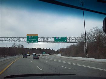
, Interstate 93
, and Interstate 293
. The southern portion of the turnpike, in Nashua
, is posted as U.S. Route 3, serving as an extension of the US-3 freeway (Northwest Expressway) from Burlington, Massachusetts
. North of Exit 7 in Nashua, the turnpike runs by itself and has no number, but parallels US-3, which is a toll-free local road variously known as Concord Street (within the city of Nashua) and the Daniel Webster Highway
(within Merrimack
and Bedford
). Approaching the Manchester
area in Bedford, the turnpike is joined by I-293 which splits off from a concurrency with NH Route 101. At Exit 4 (exits are numbered for I-293 on this stretch), NH Route 3A joins the freeway, and the concurrency passes through Manchester, near the downtown area of the city. Upon passing Manchester, Route 3A splits off at Exit 7, I-293's last northbound exit. The freeway passes into Hooksett
, and I-293 ends at an interchange with I-93. The Everett Turnpike ceases to be signed at this interchange, but joins I-93 northbound and continues towards Concord, interchanging with the southern terminus of Interstate 89
along the way. No definitive northern terminus for the turnpike exists as far as signage is concerned. This endpoint was originally at a traffic circle next to downtown Concord that has since been replaced by Exit 14 with New Hampshire Route 9.
There are two mainline toll plazas on the turnpike, in Bedford and Hooksett. The Bedford mainline toll plaza, located between Exit 12 and I-293, replaced the Merrimack
toll plaza (formerly located at what is now Exit 11) in the early 1990s. Ramp tolls also exist in Merrimack (at Exits 10, 11, and 12) and Hooksett (the on/off-ramps to I-93 Exit 11/N.H. Route 3-A). E-ZPass
readers were installed in all toll locations in 2005. A "Welcome Center" exists in Nashua (just off Exit 6), and major rest areas combined with state-run liquor stores are located on either side of the highway in Hooksett just north of the mainline toll plaza, which is located on I-93 at Exit 11.
The proposed (but mostly unbuilt) Circumferential Highway
around the east side of Nashua is defined as part of the turnpike. Henri A. Burque Highway, the surface road that U.S. Route 3 uses to get between exit 7 of the turnpike and the Daniel Webster Highway in northern Nashua, is also part of it.
 Though the Turnpike continues north to Concord, it is not signed north of the I-293 merge in Hooksett. Traveling on I-93 North, the exit for I-293 is signed as I-293/Everett Turnpike South, while the mainline is signed solely as I-93 North (as a toll highway). Traveling on I-293 North, Everett Turnpike signage stops at the merge, with I-93 North signed by itself. No indications of the northern terminus exist on I-93 in either direction. The first reassurance of the Turnpike southbound is after exiting onto I-293. No indications of the Turnpike exist on any intersecting highways north of the merge, including Interstate 89.
Mileage posts on the Turnpike are only posted from the Massachusetts state line to the interchange with I-293 and Route 101. North of this interchange, only mileposts of the respective Interstate highways are posted.
In 2010, the signs were fixed.
Toll road
A toll road is a privately or publicly built road for which a driver pays a toll for use. Structures for which tolls are charged include toll bridges and toll tunnels. Non-toll roads are financed using other sources of revenue, most typically fuel tax or general tax funds...
in New Hampshire
New Hampshire
New Hampshire is a state in the New England region of the northeastern United States of America. The state was named after the southern English county of Hampshire. It is bordered by Massachusetts to the south, Vermont to the west, Maine and the Atlantic Ocean to the east, and the Canadian...
, USA
United States
The United States of America is a federal constitutional republic comprising fifty states and a federal district...
, running 44 miles (70.8 km) from the Massachusetts
Massachusetts
The Commonwealth of Massachusetts is a state in the New England region of the northeastern United States of America. It is bordered by Rhode Island and Connecticut to the south, New York to the west, and Vermont and New Hampshire to the north; at its east lies the Atlantic Ocean. As of the 2010...
border at Nashua
Nashua, New Hampshire
-Climate:-Demographics:As of the census of 2010, there were 86,494 people, 35,044 households, and 21,876 families residing in the city. The population density was 2,719.9 people per square mile . There were 37,168 housing units at an average density of 1,202.8 per square mile...
north to Concord
Concord, New Hampshire
The city of Concord is the capital of the state of New Hampshire in the United States. It is also the county seat of Merrimack County. As of the 2010 census, its population was 42,695....
. The Everett Turnpike is named for Frederick Elwin Everett, the first Commissioner of the New Hampshire Department of Transportation
New Hampshire Department of Transportation
The State of New Hampshire Department of Transportation is a government agency of the U.S. state of New Hampshire. The NHDOT is under the executive direction of Commissioner of Transportation George Campbell. The main office of the NHDOT is located in the J.O...
.
The turnpike is part of the New Hampshire Turnpike System
New Hampshire Turnpike System
New Hampshire Turnpike System is a system of of limited access highway, of which are part of the National Highway System, within the U.S. state of New Hampshire...
, and is operated by the New Hampshire Department of Transportation
New Hampshire Department of Transportation
The State of New Hampshire Department of Transportation is a government agency of the U.S. state of New Hampshire. The NHDOT is under the executive direction of Commissioner of Transportation George Campbell. The main office of the NHDOT is located in the J.O...
's Bureau of Turnpikes.
Route description
Much of the turnpike's length has been overlapped by other numbered routes. Portions of the road are shared with U.S. Route 3U.S. Route 3
U.S. Route 3 is a north–south United States highway that runs from its southern terminus in Cambridge, Massachusetts through New Hampshire to its terminus near Third Connecticut Lake at the Canadian border, where the road continues north as Quebec Route 257.In New Hampshire parts of US 3 are...
, Interstate 93
Interstate 93
Interstate 93 is an Interstate Highway in the New England section of the United States. Its southern terminus is in Canton, Massachusetts, in the Boston metropolitan area, at Interstate 95; its northern terminus is near St. Johnsbury, Vermont, at Interstate 91...
, and Interstate 293
Interstate 293
Interstate 293 is an long loop surrounding Manchester, New Hampshire, USA roughly shaped like two sides of a triangle. Completing the loop in the northeast is Interstate 93. The southern portion of the loop shares the road with NH 101 and passes near Manchester-Boston Regional Airport and the...
. The southern portion of the turnpike, in Nashua
Nashua, New Hampshire
-Climate:-Demographics:As of the census of 2010, there were 86,494 people, 35,044 households, and 21,876 families residing in the city. The population density was 2,719.9 people per square mile . There were 37,168 housing units at an average density of 1,202.8 per square mile...
, is posted as U.S. Route 3, serving as an extension of the US-3 freeway (Northwest Expressway) from Burlington, Massachusetts
Burlington, Massachusetts
Burlington is a town in Middlesex County, Massachusetts, United States. The population was 24,498 at the 2010 census.- History :It is believed that Burlington takes its name from the English town of Bridlington, however this has never been confirmed....
. North of Exit 7 in Nashua, the turnpike runs by itself and has no number, but parallels US-3, which is a toll-free local road variously known as Concord Street (within the city of Nashua) and the Daniel Webster Highway
Daniel Webster Highway
Daniel Webster Highway is the name for several sections of U.S. Route 3 in New Hampshire. The highway is named after 19th century statesman Daniel Webster, a New Hampshire native.-Extent:...
(within Merrimack
Merrimack, New Hampshire
Merrimack is a town in Hillsborough County, New Hampshire, United States. The population was 25,494 at the 2010 census, making it the eighth-largest municipality in New Hampshire....
and Bedford
Bedford, New Hampshire
-Demographics:As of the Census of 2000, there were 18,274 people, 6,251 households, and 5,125 families residing in the town. The population density was 556.6 people per square mile . There were 6,401 housing units at an average density of 195.0 per square mile...
). Approaching the Manchester
Manchester, New Hampshire
Manchester is the largest city in the U.S. state of New Hampshire, the tenth largest city in New England, and the largest city in northern New England, an area comprising the states of Maine, New Hampshire, and Vermont. It is in Hillsborough County along the banks of the Merrimack River, which...
area in Bedford, the turnpike is joined by I-293 which splits off from a concurrency with NH Route 101. At Exit 4 (exits are numbered for I-293 on this stretch), NH Route 3A joins the freeway, and the concurrency passes through Manchester, near the downtown area of the city. Upon passing Manchester, Route 3A splits off at Exit 7, I-293's last northbound exit. The freeway passes into Hooksett
Hooksett, New Hampshire
Hooksett is a town in Merrimack County, New Hampshire, United States. The population was 13,451 at the 2010 census. The town is located between Manchester, the state's largest city, and Concord, the state capital...
, and I-293 ends at an interchange with I-93. The Everett Turnpike ceases to be signed at this interchange, but joins I-93 northbound and continues towards Concord, interchanging with the southern terminus of Interstate 89
Interstate 89
Interstate 89 is an interstate highway in the New England region of the United States travelling between Bow, New Hampshire and Highgate Springs, Vermont. As with all odd-numbered primary interstates, I-89 is signed as a north–south highway...
along the way. No definitive northern terminus for the turnpike exists as far as signage is concerned. This endpoint was originally at a traffic circle next to downtown Concord that has since been replaced by Exit 14 with New Hampshire Route 9.
There are two mainline toll plazas on the turnpike, in Bedford and Hooksett. The Bedford mainline toll plaza, located between Exit 12 and I-293, replaced the Merrimack
Merrimack, New Hampshire
Merrimack is a town in Hillsborough County, New Hampshire, United States. The population was 25,494 at the 2010 census, making it the eighth-largest municipality in New Hampshire....
toll plaza (formerly located at what is now Exit 11) in the early 1990s. Ramp tolls also exist in Merrimack (at Exits 10, 11, and 12) and Hooksett (the on/off-ramps to I-93 Exit 11/N.H. Route 3-A). E-ZPass
E-ZPass
E-ZPass is an electronic toll-collection system used on most tolled roads, bridges, and tunnels in the northeastern US, south to Virginia and West Virginia, and west to Illinois. Currently, there are 25 agencies spread across 14 states that make up the . All member agencies use the same technology,...
readers were installed in all toll locations in 2005. A "Welcome Center" exists in Nashua (just off Exit 6), and major rest areas combined with state-run liquor stores are located on either side of the highway in Hooksett just north of the mainline toll plaza, which is located on I-93 at Exit 11.
The proposed (but mostly unbuilt) Circumferential Highway
Circumferential Highway (Nashua)
The Circumferential Highway is the commonly accepted name for a bypass route around the city of Nashua in southern New Hampshire, the majority of which has not yet been built. The purpose of the highway is to provide an alternate route for commuters to access the F.E. Everett Turnpike and U.S....
around the east side of Nashua is defined as part of the turnpike. Henri A. Burque Highway, the surface road that U.S. Route 3 uses to get between exit 7 of the turnpike and the Daniel Webster Highway in northern Nashua, is also part of it.
Signage issues
Mileage posts on the Turnpike are only posted from the Massachusetts state line to the interchange with I-293 and Route 101. North of this interchange, only mileposts of the respective Interstate highways are posted.
In 2010, the signs were fixed.
Exit list
| County | Town | Mile (km) |
Exit # Exit number An exit number is a number assigned to a road junction, usually an exit from a freeway. It is usually marked on the same sign as the destinations of the exit, as well as a sign in the gore.... |
Destinations | Notes | ||
|---|---|---|---|---|---|---|---|
| Old | New | ||||||
 U.S. Route 3 Freeway continues south into Massachusetts southbound U.S. Route 3 Freeway continues south into Massachusetts southbound begins overlapped with begins overlapped with |
|||||||
| Hillsborough Hillsborough County, New Hampshire -Demographics:As of the census of 2000, there were 380,841 people, 144,455 households, and 98,807 families residing in the county. The population density was 435 people per square mile . There were 149,961 housing units at an average density of 171 per square mile... |
Nashua | 0.50 (0.80) |
1 | 1 | Spit Brook Road - South Nashua | ||
| 1.49 (2.40) |
2 | 2 (1A) | TO  To NH Route 3A - Daniel Webster Highway To NH Route 3A - Daniel Webster HighwayDaniel Webster Highway Daniel Webster Highway is the name for several sections of U.S. Route 3 in New Hampshire. The highway is named after 19th century statesman Daniel Webster, a New Hampshire native.-Extent:... ; Hudson Hudson, New Hampshire Hudson is a town in Hillsborough County, New Hampshire, United States. The population was 24,467 at the 2010 census.The primary settlement in town, where 7,336 people resided at the 2010 census, is defined as the Hudson census-designated place and is located at the junctions of New Hampshire... (Circumferential Highway Circumferential Highway (Nashua) The Circumferential Highway is the commonly accepted name for a bypass route around the city of Nashua in southern New Hampshire, the majority of which has not yet been built. The purpose of the highway is to provide an alternate route for commuters to access the F.E. Everett Turnpike and U.S.... ) |
Ramp from Exit 1 northbound collector-distributor lane numbered Exit 1A. | |||
| 2.59 (4.17) |
1 | 3 | 3 | Daniel Webster Highway Daniel Webster Highway Daniel Webster Highway is the name for several sections of U.S. Route 3 in New Hampshire. The highway is named after 19th century statesman Daniel Webster, a New Hampshire native.-Extent:... - South Nashua |
Southbound exit/northbound entrance only. | ||
| 3.18 (5.12) |
4 | 4 | East Dunstable Road | Formerly signed as "East Dunstable Road / FAA Center Boston Air Route Traffic Control Center Boston Air Route Traffic Control Center is located in Nashua, New Hampshire, United States. The Boston ARTCC is one of 22 Air Route Traffic Control Centers in the United States.... ." The "FAA Center" signage was removed at the request of the Federal Aviation Administration Federal Aviation Administration The Federal Aviation Administration is the national aviation authority of the United States. An agency of the United States Department of Transportation, it has authority to regulate and oversee all aspects of civil aviation in the U.S... shortly after the September 11, 2001 attacks September 11, 2001 attacks The September 11 attacks The September 11 attacks The September 11 attacks (also referred to as September 11, September 11th or 9/119/11 is pronounced "nine eleven". The slash is not part of the pronunciation... . |
|||
| 4.69 (7.55) |
2 | 5 | 5E-W |  TO TO  NH Route 111 to NH Route 111A – Nashua NH Route 111 to NH Route 111A – NashuaNashua, New Hampshire -Climate:-Demographics:As of the census of 2010, there were 86,494 people, 35,044 households, and 21,876 families residing in the city. The population density was 2,719.9 people per square mile . There were 37,168 housing units at an average density of 1,202.8 per square mile... ; Hudson Hudson, New Hampshire Hudson is a town in Hillsborough County, New Hampshire, United States. The population was 24,467 at the 2010 census.The primary settlement in town, where 7,336 people resided at the 2010 census, is defined as the Hudson census-designated place and is located at the junctions of New Hampshire... ; Pepperell, Massachusetts Pepperell, Massachusetts Pepperell is a town in Middlesex County, Massachusetts, United States. The population was 11,497 at the 2010 census. It includes the village of East Pepperell.-History:... |
|||
| 5.13 (8.25) |
5A | Simon Street | Northbound exit only. (Past signs listed this as Exit "5E-A") | ||||
| 6.22 (10.01) |
6 | 6 |  NH Route 130 - Broad Street; Hollis NH Route 130 - Broad Street; Hollis |
||||
| 6.74 (10.85) |
3 | 7 | 7E-W |   U.S. Route 3 north; NH Route 101A - Nashua U.S. Route 3 north; NH Route 101A - NashuaNashua, New Hampshire -Climate:-Demographics:As of the census of 2010, there were 86,494 people, 35,044 households, and 21,876 families residing in the city. The population density was 2,719.9 people per square mile . There were 37,168 housing units at an average density of 1,202.8 per square mile... ; Downtown; Amherst Amherst, New Hampshire Amherst is a town in Hillsborough County, New Hampshire, United States. The population was 11,201 at the 2010 census. Amherst is home to Ponemah Bog Wildlife Sanctuary, Hodgman State Forest, the Joe English Reservation and Baboosic Lake.... ; Milford Milford, New Hampshire Milford is a town in Hillsborough County, New Hampshire, United States, on the Souhegan River. The population was 15,115 at the 2010 census. It is the retail and manufacturing center of a six-town area known informally as the Souhegan Valley.... |
U.S. Route 3 joins southbound and leaves northbound.Exit 7E provides access to US-3 North and NH-101A East.Exit 7W provides access to NH-101A West. | ||
| leaves |
|||||||
| 7.66 (12.33) |
7W | 8 |  NH Route 101A west - Amherst; Milford NH Route 101A west - Amherst; MilfordMilford, New Hampshire Milford is a town in Hillsborough County, New Hampshire, United States, on the Souhegan River. The population was 15,115 at the 2010 census. It is the retail and manufacturing center of a six-town area known informally as the Souhegan Valley.... (NH Route 101A Bypass west) |
Locally known as Somerset Parkway | |||
| Merrimack Merrimack, New Hampshire Merrimack is a town in Hillsborough County, New Hampshire, United States. The population was 25,494 at the 2010 census, making it the eighth-largest municipality in New Hampshire.... |
N/A | (9) | No exit. Possible future use. | Reserved for a northern terminus interchange of the Circumferential Highway. | |||
| 9.83 (15.82) |
10 | TO To U.S. Route 3 - Industrial Drive |
SB entrance/NB exit toll: 50 cents. 35 cents for NH EZPass users. No toll for other ramps. | ||||
| 11.10 (17.86) |
4 | 8 | 11 | TO To U.S. Route 3 - Merrimack Merrimack, New Hampshire Merrimack is a town in Hillsborough County, New Hampshire, United States. The population was 25,494 at the 2010 census, making it the eighth-largest municipality in New Hampshire.... |
Sb entrance/NB exit toll: 50 cents. 35 cents for NH EZPass users. No toll for other ramps. | ||
| 14.94 (24.04) |
12 | TO To U.S. Route 3 - Bedford Road |
Northbound exit/southbound entrance only. Entrance and exit toll: 50 cents. 35 cents for NH EZPass users. |
||||
| Bedford | Bedford Toll Plaza | Auto toll: $1.00; 70 cents for NH EZPass users | |||||
| N/A | (13) | Future exit: Manchester Airport Manchester-Boston Regional Airport Manchester-Boston Regional Airport , commonly referred to simply as "Manchester Airport," is a public airport located three miles south of the central business district of Manchester, New Hampshire on the county line of Hillsborough and Rockingham counties... Access Road |
Under construction; completion expected in 2011. | ||||
| 19.39 (31.21) |
5 | 10 |      Interstate 293 South/NH Route 101 East -Portsmouth Interstate 293 South/NH Route 101 East -PortsmouthPortsmouth, New Hampshire Portsmouth is a city in Rockingham County, New Hampshire in the United States. It is the largest city but only the fourth-largest community in the county, with a population of 21,233 at the 2010 census...  TO TO  NH Route 101 West to U.S. Route 3; to NH Route 114 - Exeter NH Route 101 West to U.S. Route 3; to NH Route 114 - ExeterExeter, New Hampshire Exeter is a town in Rockingham County, New Hampshire, United States. The town's population was 14,306 at the 2010 census. Exeter was the county seat until 1997, when county offices were moved to neighboring Brentwood... ; Bedford Bedford, New Hampshire -Demographics:As of the Census of 2000, there were 18,274 people, 6,251 households, and 5,125 families residing in the town. The population density was 556.6 people per square mile . There were 6,401 housing units at an average density of 195.0 per square mile... ; Milford Milford, New Hampshire Milford is a town in Hillsborough County, New Hampshire, United States, on the Souhegan River. The population was 15,115 at the 2010 census. It is the retail and manufacturing center of a six-town area known informally as the Souhegan Valley.... |
I-293 joins northbound and leaves southbound. | |||
| joins Exit numbering and mileposts revert to scheme of I-293. Indicated mileages are respective of the Turnpike but are not posted. |
|||||||
| Manchester Manchester, New Hampshire Manchester is the largest city in the U.S. state of New Hampshire, the tenth largest city in New England, and the largest city in northern New England, an area comprising the states of Maine, New Hampshire, and Vermont. It is in Hillsborough County along the banks of the Merrimack River, which... |
|||||||
| 21.22 (34.15) |
6 | 4 | 4 |    U.S. Route 3 U.S. Route 3U.S. Route 3 U.S. Route 3 is a north–south United States highway that runs from its southern terminus in Cambridge, Massachusetts through New Hampshire to its terminus near Third Connecticut Lake at the Canadian border, where the road continues north as Quebec Route 257.In New Hampshire parts of US 3 are... ; NH Route 3A South; NH Route 114A - Manchester |
Route 3A joins northbound and leaves southbound. | ||
| joins |
|||||||
| 21.96 (35.34) |
5 | Granite Street — Downtown | Full interchange as of Oct. 2008 | ||||
| 23.27 (37.45) |
7 | 5 | 6 | Amoskeag Street; Goffstown Road | |||
| 24.25 (39.03) |
7 | NH Route 3A north - Hooksett Hooksett, New Hampshire Hooksett is a town in Merrimack County, New Hampshire, United States. The population was 13,451 at the 2010 census. The town is located between Manchester, the state's largest city, and Concord, the state capital... |
Northbound exit/southbound entrance only.Route 3A leaves northbound and leaves southbound. | ||||
| leaves |
|||||||
| Merrimack Merrimack County, New Hampshire -Demographics:As of the census of 2000, there were 136,225 people, 51,843 households, and 35,460 families residing in the county. The population density was 146 people per square mile . There were 56,244 housing units at an average density of 60 per square mile... |
Hooksett Hooksett, New Hampshire Hooksett is a town in Merrimack County, New Hampshire, United States. The population was 13,451 at the 2010 census. The town is located between Manchester, the state's largest city, and Concord, the state capital... |
||||||
| 27.18 (43.74) |
 Interstate 93 South - Salem Interstate 93 South - SalemSalem, New Hampshire Salem is a town in Rockingham County, New Hampshire, United States. The population was 28,776 at the 2010 census. Salem is a marketing and distributing center north of Boston, with a major amusement attraction, Canobie Lake Park, and a large shopping mall, the Mall at Rockingham Park.- History :The... ; Boston, Massachusetts |
I-93 joins northbound and leaves southbound.I-293 ends northbound and begins southbound.I-293 mainline merges into I-93 North. | |||||
| ends at joins Exit numbering and mileposts revert to scheme of I-93. Indicated mileages are respective of the Turnpike but are not posted. |
|||||||
| Hooksett Toll Plaza | Auto toll: $1.00; 70 cents for NH EZPass users | ||||||
| 29.52 (47.51) |
8 | 6 | 11 | NH Route 3A - Hooksett Hooksett, New Hampshire Hooksett is a town in Merrimack County, New Hampshire, United States. The population was 13,451 at the 2010 census. The town is located between Manchester, the state's largest city, and Concord, the state capital... |
Entrance and exit toll: 50 cents; 35 cents for NH EZPass users. | ||
| Bow Bow, New Hampshire Bow is a town in Merrimack County, New Hampshire, United States. The population was 7,519 at the 2010 census.- History :Incorporated in 1727, the town was one of several formed to ease population pressures on the Seacoast. The town's name comes from its establishment along a bend, or "bow", in the... |
36.24 (58.32) |
9 |   Interstate 89 north - Lebanon; White River Junction, VT Interstate 89 north - Lebanon; White River Junction, VT |
||||
| Concord Concord, New Hampshire The city of Concord is the capital of the state of New Hampshire in the United States. It is also the county seat of Merrimack County. As of the 2010 census, its population was 42,695.... |
36.91 (59.40) |
10 | 12S-N | TO NH Route 3A to Interstate 89 - Bow Junction Bow, New Hampshire Bow is a town in Merrimack County, New Hampshire, United States. The population was 7,519 at the 2010 census.- History :Incorporated in 1727, the town was one of several formed to ease population pressures on the Seacoast. The town's name comes from its establishment along a bend, or "bow", in the... ; South Main Street |
|||
| 38.08 (61.28) |
13 | U.S. Route 3 - Manchester Street; Downtown |
|||||
| 39.20 (63.09) |
14 |  NH Route 9 - Loudon Road; State Offices NH Route 9 - Loudon Road; State Offices |
|||||
| ends; Interstate 93 continues north towards Plymouth Plymouth, New Hampshire Plymouth is a town in Grafton County, New Hampshire, United States, in the White Mountains Region. Plymouth is located at the convergence of the Pemigewasset and Baker rivers. The population was 6,990 at the 2010 census... |
|||||||