
.gif)
Interstate 440 (North Carolina)
Encyclopedia
Interstate 440 in North Carolina
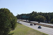
, also known as the Raleigh Beltline and the Cliff Benson Beltline, is a 16.4-mile (26.4-km) partial beltway that nearly encircles central Raleigh
. Prior to August 2002, it was a complete loop and shared a concurrency with its parent, Interstate 40
along the loop's southern segment (Tom Bradshaw Freeway). I-440 was labeled with "Inner" and "Outer" lanes, making it one of the few Interstate Highways in the United States
not primarily labeled with compass directions (e.g. east/west). It has now been truncated to avoid confusion, especially with the I-540
"Outer Loop" and is being relabeled with an east–west orientation.
 I-440 is labeled as an east–west highway which forms a partial loop around the north of downtown Raleigh. Both the eastern and western terminus are at I-40. Exit numbers
follow the standard Interstate pattern, increasing from west to east. At the western terminus, the mainline of the road continues on as the U.S. 1
/64
expressway through Cary. Other major junctions include the Raleigh-Chapel Hill Expressway
at exit 4, U.S. 70
at exit 7, U.S. 1
/401
at exit 11, and U.S. 64/264
at exit 14. I-440 shares its route with U.S. 1 between exit 1 and exit 11, and with U.S. 64 between exit 14 and exit 16.
Prior to 2002, the route also followed I-40 south of downtown Raleigh and was labeled "inner" and "outer" rather than using the standard cardinal direction
s. With the opening of a second loop
around Raleigh, I-440 was truncated to its current length, and its designation changed to the standard east/west labeling to avoid confusion with the new road. Signage has been slow to change on parts of the road, and in some places still reflects the old routing and designation. By 2009, many, but not all, of the signs had been changed.
Between Wade Ave. (Exit 4) and Capital Blvd. (Exit 11) north of Downtown Raleigh, I-440 has between six and eight travel lanes. As of 2005, average annual traffic volume varies between 112,000 vpd and 138,000 vpd on this section.
Between Capital Blvd (Exit 11) and I-40 (Exit 16) east of Downtown Raleigh, I-440 has between six and eight travel lanes. As of 2005, average annual traffic volume varies between 88,000 vpd and 108,000 vpd on this section.
 In 2002, the North Carolina Department of Transportation decided to replace the inner/outer labeling with an east–west orientation and remove I-440 along its concurrency with I-40. This decision was primarily made to prevent confusion with the I-540 Outer Loop around Wake County
. The FHWA route log has been updated to show the shortened distance. By 2009 many, but not all, signs reflecting the old routing and designation have been removed or updated. Signs are being changed as they are replaced; new signs placed on US 1 do not show I-440 on the southern segment and show I-440 with east/west compass directions.
 Prior to 1991, the northern part of the beltline was designated, but unsigned, as Business Interstate 40 while the southern part remained Interstate 40. Later, the I-440 designation was approved and signed along the entire loop.
All exits are in Wake County.
North Carolina
North Carolina is a state located in the southeastern United States. The state borders South Carolina and Georgia to the south, Tennessee to the west and Virginia to the north. North Carolina contains 100 counties. Its capital is Raleigh, and its largest city is Charlotte...
, also known as the Raleigh Beltline and the Cliff Benson Beltline, is a 16.4-mile (26.4-km) partial beltway that nearly encircles central Raleigh
Raleigh, North Carolina
Raleigh is the capital and the second largest city in the state of North Carolina as well as the seat of Wake County. Raleigh is known as the "City of Oaks" for its many oak trees. According to the U.S. Census Bureau, the city's 2010 population was 403,892, over an area of , making Raleigh...
. Prior to August 2002, it was a complete loop and shared a concurrency with its parent, Interstate 40
Interstate 40 in North Carolina
Interstate 40 runs through the state of North Carolina from the Tennessee state line in the west to its eastern terminus in Wilmington.-Pigeon River Gorge:...
along the loop's southern segment (Tom Bradshaw Freeway). I-440 was labeled with "Inner" and "Outer" lanes, making it one of the few Interstate Highways in the United States
United States
The United States of America is a federal constitutional republic comprising fifty states and a federal district...
not primarily labeled with compass directions (e.g. east/west). It has now been truncated to avoid confusion, especially with the I-540
Interstate 540 (North Carolina)
In the U.S. state of North Carolina, Interstate 540 and North Carolina Highway 540 share a partially completed interstate grade beltway, also known as the Raleigh Outer Loop, around the city of Raleigh. -Route description:...
"Outer Loop" and is being relabeled with an east–west orientation.
Route description
Exit numbers in the United States
An exit number is a number assigned to a road junction, usually an exit from a freeway. It is usually marked on the same sign as the destinations of the exit, as well as a sign in the gore.-Interstate Highways:...
follow the standard Interstate pattern, increasing from west to east. At the western terminus, the mainline of the road continues on as the U.S. 1
U.S. Route 1
U.S. Route 1 is a major north–south U.S. Highway that serves the East Coast of the United States. It runs 2,377 miles from Fort Kent, Maine at the Canadian border south to Key West, Florida. U.S. 1 generally parallels Interstate 95, though it is significantly farther west between...
/64
U.S. Route 64
U.S. Route 64 is an east–west United States highway that runs for 2,326 miles from eastern North Carolina to just southwest of the Four Corners in northeast Arizona. The western terminus is at U.S. Route 160 in Teec Nos Pos, Arizona. The highway's eastern terminus is at NC 12 and U.S. Route...
expressway through Cary. Other major junctions include the Raleigh-Chapel Hill Expressway
Wade Avenue
Wade Avenue is a major road in the The Triangle region of North Carolina that links Interstate 40, Interstate 440 , and downtown Raleigh...
at exit 4, U.S. 70
U.S. Route 70
U.S. Route 70 is an east–west United States highway that runs for 2,385 miles from eastern North Carolina to east-central Arizona. As can be derived from its number, it is a major east–west highway of the Southern and Southwestern United States...
at exit 7, U.S. 1
U.S. Route 1
U.S. Route 1 is a major north–south U.S. Highway that serves the East Coast of the United States. It runs 2,377 miles from Fort Kent, Maine at the Canadian border south to Key West, Florida. U.S. 1 generally parallels Interstate 95, though it is significantly farther west between...
/401
U.S. Route 401
U.S. Route 401 is an north–south United States highway, a spur of U.S. Route 1, that traverses along the fall line from Sumter, South Carolina to Interstate 85 near Wise, North Carolina.-Route description:...
at exit 11, and U.S. 64/264
U.S. Route 264
U.S. Route 264 is an east–west United States highway that runs for from Raleigh to Manns Harbor, entirely in the U.S. state of North Carolina.-Route description:...
at exit 14. I-440 shares its route with U.S. 1 between exit 1 and exit 11, and with U.S. 64 between exit 14 and exit 16.
Prior to 2002, the route also followed I-40 south of downtown Raleigh and was labeled "inner" and "outer" rather than using the standard cardinal direction
Cardinal direction
The four cardinal directions or cardinal points are the directions of north, east, south, and west, commonly denoted by their initials: N, E, S, W. East and west are at right angles to north and south, with east being in the direction of rotation and west being directly opposite. Intermediate...
s. With the opening of a second loop
Interstate 540 (North Carolina)
In the U.S. state of North Carolina, Interstate 540 and North Carolina Highway 540 share a partially completed interstate grade beltway, also known as the Raleigh Outer Loop, around the city of Raleigh. -Route description:...
around Raleigh, I-440 was truncated to its current length, and its designation changed to the standard east/west labeling to avoid confusion with the new road. Signage has been slow to change on parts of the road, and in some places still reflects the old routing and designation. By 2009, many, but not all, of the signs had been changed.
Nearby points of interest
- RBC Center via Wade AvenueWade AvenueWade Avenue is a major road in the The Triangle region of North Carolina that links Interstate 40, Interstate 440 , and downtown Raleigh...
(exit 4) - Carter-Finley StadiumCarter-Finley StadiumCarter-Finley Stadium is home to the North Carolina State University Wolfpack football team. It was opened in 1966 and now has a seating capacity of 57,583 seats....
via Wade AvenueWade AvenueWade Avenue is a major road in the The Triangle region of North Carolina that links Interstate 40, Interstate 440 , and downtown Raleigh...
(exit 4) - North Carolina State FairNorth Carolina State FairThe North Carolina State Fair is an annual fair and agricultural exposition held in Raleigh, North Carolina, and organized by the North Carolina Department of Agriculture and Consumer Services....
grounds via NC 54/Hillsborough Street (exit 3) - Meredith CollegeMeredith CollegeMeredith College is a liberal arts women's college located in Raleigh, North Carolina. For the 2010-2011 academic year, there were approximately 2,300 students enrolled, including about 350 graduate students, making Meredith the largest women's college in the southeastern United States...
via NC 54/Hillsborough Street (exit 3) - North Carolina State UniversityNorth Carolina State UniversityNorth Carolina State University at Raleigh is a public, coeducational, extensive research university located in Raleigh, North Carolina, United States. Commonly known as NC State, the university is part of the University of North Carolina system and is a land, sea, and space grant institution...
via Western Boulevard (exit 2A) - Crabtree Valley MallCrabtree Valley MallCrabtree Valley Mall is a regional mall located in Raleigh, North Carolina. At , it is the largest enclosed mall in the Triangle. Crabtree Valley contains over 220 stores and is anchored by Belk, Sears, and Macy's. Higher-end restaurants located in the mall include The Cheesecake Factory, P. F...
via US 70/NC 50/Glenwood Avenue (exit 7) - North Hills via Six Forks Road (exit 8B)
- The Time Warner Cable Music Pavilion at Walnut Creek via Poole Road (exit 15)
Volume and capacity
Between US1-64 (Exit 1A) and Wade Ave. (Exit 4) west of Downtown Raleigh, I-440 has four travel lanes. As of 2005, average annual daily traffic volume varies between 78,000 vpd and 90,000 vpd on this section.Between Wade Ave. (Exit 4) and Capital Blvd. (Exit 11) north of Downtown Raleigh, I-440 has between six and eight travel lanes. As of 2005, average annual traffic volume varies between 112,000 vpd and 138,000 vpd on this section.
Between Capital Blvd (Exit 11) and I-40 (Exit 16) east of Downtown Raleigh, I-440 has between six and eight travel lanes. As of 2005, average annual traffic volume varies between 88,000 vpd and 108,000 vpd on this section.
Truncation and removal of Inner/Outer labels
Wake County, North Carolina
Wake County is a county located in the U.S. state of North Carolina. As of the 2010 census, the population was 900,993 making it North Carolina's second most populated county...
. The FHWA route log has been updated to show the shortened distance. By 2009 many, but not all, signs reflecting the old routing and designation have been removed or updated. Signs are being changed as they are replaced; new signs placed on US 1 do not show I-440 on the southern segment and show I-440 with east/west compass directions.
Interstate 40 Business
Exit list
Exits are numbered by mile marker, beginning at Exit 1 in the southwest and continuing east. With the truncation of I-440 and assignment of east/west direction, exits are now numbered west to east.All exits are in Wake County.
| # Exit number An exit number is a number assigned to a road junction, usually an exit from a freeway. It is usually marked on the same sign as the destinations of the exit, as well as a sign in the gore.... |
Destinations | Notes |
|---|---|---|
| Westbound exit and eastbound entrance; West end of US-1 overlap | ||
| 1 | , Airport | Signed as exits 1A (east) and 1B (west) |
| 1C | Jones Franklin Road | |
| 1D | Melbourne Road | Westbound exit and eastbound entrance |
| 2A | Western Boulevard – NC State University, Downtown Raleigh | Westbound entrance is a left entrance |
| 2B | Cary Cary, North Carolina Cary is a large town and suburb of Raleigh, North Carolina in Wake and Chatham counties in the U.S. state of North Carolina. Located almost entirely in Wake County, it is the second largest municipality in that county and the third largest municipality in The Triangle after Raleigh and Durham... |
|
| 3 | ||
| 4 | Signed as exits 4A (east) and 4B (west) westbound | |
| 5 | Lake Boone Trail | |
| 6 | Ridge Road | Westbound exit is part of exit 7A |
| 7 | Signed as exits 7A (south) and 7B (north) westbound | |
| 8 | Six Forks Rd – North Hills | Signed as exits 8A (south) and 8B (north) |
| 10 | Wake Forest Road | |
| 11 | East end of US 1 overlap; signed as exits 11A (south) and 11B (north) westbound | |
| 12 | Yonkers Road | Eastbound exit and entrance |
| 12 | Brentwood Road | Westbound exit and entrance |
| 13A | New Bern Avenue – Downtown Raleigh | |
| 13B | ||
| 14 | West end of US 64 overlap | |
| 15 | Poole Road | |
| 16 | Eastbound exit and westbound entrance | |
| Eastbound exit and westbound entrance; East end of US 64 overlap |