
Interstate 95 in North Carolina
Encyclopedia
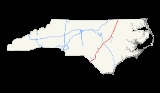
Interstate 95
is a major Interstate Highway, running along the East Coast
of the United States
from Florida
to Maine
. In North Carolina
, I-95 runs diagonally across the eastern third of the state, from Rowland
in the southwest to Roanoke Rapids
in the northeast of the Inner Banks
.
 Interstate 95 in North Carolina serves as the informal western border of the Inner Banks
region of the state. It begins the SC
-NC
border near Rowland, N.C.
and Pleasant Hill, N.C.
, overlaping concurrency of US 301
running parallel to Interstate 95 throughout the state, and into South Carolina
and Virginia
as well between Exits 10 and 22 from Raynham
to Lumberton
with an interchange of I-74
and US 74
concurrency ending terminus of I-795
and US 117
in Wilson
last exit as NC 48
near Weldon, Exits 58-34 was I-295
near St. Pauls
and Fayetteville
on the side of the line was the attraction South of the Border
of the South Carolina
state entering Rowland
.
) pulled into a rest stop on Interstate 95 to take a nap. Daniel Green (who later changed his name to Lord D.A.A.S. U'Allah)[2] and Larry Martin Demery shot Jordan to death while he slept in his car and proceeded to steal the vehicle. His body was found on August 3 in a Bennettsville, South Carolina swamp, but was not positively identified until August 13
Green and Demery made several calls from Jordan's cell phone and as a result were quickly captured. They had taken other items from the car including two NBA championship rings given to Jordan, Sr. by his son. Demery was wearing a Michael Jordan T-shirt at the time of his arrest. Demery claims that they had planned only to tie up their victim and that Green pulled the trigger for no reason. Both were convicted and sentenced to life imprisonment for this and other violent crimes.
|-
!County
!Location
!Exit
!Destinations
!Notes
|-
!colspan=5|Dillon County, South Carolina-Robeson County, North Carolina
Border
.svg.png) Interstate 95
Interstate 95
leaves South Carolina
|-
|rowspan=13|Robeson
|
|1
|
|Signed as exits 1A (south) and 1B (north) southbound
|-
|
|2
|
|
|-
|
|7
|East Raynham Road – McDonald
, Raynham
|
|-
|
|style="background:#ddffdd"|10
|style="background:#ddffdd"|
|style="background:#ddffdd"|South end of US 301 overlap
|-
|
|13
|
|Signed as exits 13A (east) and 13B (west)
|-
|rowspan=5|Lumberton
|17
|
|
|-
!colspan=3|Bridge across the Lumber River
|-
|19
|Carthage Road
|
|-
|20
|
|
|-
|style="background:#ddffdd"|22
|style="background:#ddffdd"|
|style="background:#ddffdd"|North end of US 301 overlap
|-
|
|25
|
|
|-
|rowspan=2|St. Pauls
|31
|
|
|-
|33
|
|
|-
|rowspan=12|Cumberland
|Hope Mills
|40
|
|
|-
|
|41
|
|
|-
|
|44
|Snow Hill Road – Fayetteville Regional Airport
|
|-
|
|46
|
|Signed as exits 46A (south) and 46B (north)
|-
|
!colspan=3|Bridge across the Cape Fear River
|-
|rowspan=5|Fayetteville
|49
|
|
|-
|52
|
|Signed as exits 52A (east) and 52B (west)
|-
|55
|Murphy Road
|
|-
|56
|
|
|-
|58
|
|
|-
|
|61
|Wade-Steadman Road – Wade
|
|-
|
|65
|
|
|-
|rowspan=6|Harnett
|
|70
|Bud Hawkins Road
|
|-
|
|71
|Long Branch Road
|
|-
|rowspan=2|Dunn
|72
|Pope Road
|
|-
|73
|
|
|-
|
|75
|Jonesboro Road
|
|-
|
|77
|Hodges Chapel Road
|
|-
|rowspan=14|Johnston
|Benson
|79
|
|
|-
|
|81
|
|Signed as exits 81A (west) and 81B (east) southbound
|-
|rowspan=2|Four Oaks
|87
|Keen Road – Four Oaks
|
|-
|90
|
|
|-
|
!colspan=3|Bridge across the Neuse River
|-
|rowspan=2|Smithfield
|93
|Brogden Road – Smithfield
|
|-
|95
|
|
|-
|Selma
|97
|
|
|-
|
|98
|Pine Level-Selma Road – Selma
|
|-
|
|101
|Pittman Road
|
|-
|Micro
|102
|East Main Street – Micro
|
|-
|
|105
|Bagley Road
|
|-
|
|106
|Truck Stop Road
|
|-
|
|107
|
|
|-
|rowspan=3|Wilson
|rowspan=3|Wilson
|116
|
|
|-
|119
|
|Signed as exits 119A (east/south) and 119B (west)
|-
|121
|
|
|-
|rowspan=7|Nash
|
|127
|
|
|-
|
!colspan=3|Bridge across the Tar River
|-
|
|
|Sunset Avenue
|In planning stages with construction scheduled for 2019.
|-
|Rocky Mount
|138
|
|Signed as exits 138A (west) 138B (east)
|-
|Dortches
|141
|
|
|-
|
|145
|
|
|-
|
|150
|
|
|-
|rowspan=6|Halifax
|
|154
|
|
|-
|
|160
|
|
|-
|
|168
|
|
|-
|rowspan=2|Roanoke Rapids
|171
|
|
|-
|173
|
|
|-
|rowspan=2|
!rowspan=2 colspan=3|Bridge across the Roanoke River
(Lake Gaston
)
|-
|rowspan=3|Northampton
|-
|rowspan=2|Gaston
|176
|
|
|-
|180
|
|
|-
!colspan=5|Northampton County, North Carolina
-Greensville County, Virginia
Border
 Interstate 95 continues north into Virginia
Interstate 95
Interstate 95 is the main highway on the East Coast of the United States, running parallel to the Atlantic Ocean from Maine to Florida and serving some of the most populated urban areas in the country, including Boston, Providence, New Haven, New York City, Newark, Philadelphia, Baltimore,...
is a major Interstate Highway, running along the East Coast
East Coast of the United States
The East Coast of the United States, also known as the Eastern Seaboard, refers to the easternmost coastal states in the United States, which touch the Atlantic Ocean and stretch up to Canada. The term includes the U.S...
of the United States
United States
The United States of America is a federal constitutional republic comprising fifty states and a federal district...
from Florida
Florida
Florida is a state in the southeastern United States, located on the nation's Atlantic and Gulf coasts. It is bordered to the west by the Gulf of Mexico, to the north by Alabama and Georgia and to the east by the Atlantic Ocean. With a population of 18,801,310 as measured by the 2010 census, it...
to Maine
Maine
Maine is a state in the New England region of the northeastern United States, bordered by the Atlantic Ocean to the east and south, New Hampshire to the west, and the Canadian provinces of Quebec to the northwest and New Brunswick to the northeast. Maine is both the northernmost and easternmost...
. In North Carolina
North Carolina
North Carolina is a state located in the southeastern United States. The state borders South Carolina and Georgia to the south, Tennessee to the west and Virginia to the north. North Carolina contains 100 counties. Its capital is Raleigh, and its largest city is Charlotte...
, I-95 runs diagonally across the eastern third of the state, from Rowland
Rowland, North Carolina
Rowland is a town in Robeson County, North Carolina, United States. The population was 1,146 at the 2000 census.-Geography:Rowland is located at ....
in the southwest to Roanoke Rapids
Roanoke Rapids, North Carolina
Roanoke Rapids is a city in Halifax County, North Carolina, United States. The population was 16,957 at the 2000 census. It is the principal city of the Roanoke Rapids Micropolitan Statistical Area.-Geography:...
in the northeast of the Inner Banks
Inner Banks
The Inner Banks is a term used by some to describe the inland coastal region of eastern North Carolina, an area on the East Coast of the United States that is 22,227 square-miles by its broadest definition...
.
Route description
Inner Banks
The Inner Banks is a term used by some to describe the inland coastal region of eastern North Carolina, an area on the East Coast of the United States that is 22,227 square-miles by its broadest definition...
region of the state. It begins the SC
South Carolina
South Carolina is a state in the Deep South of the United States that borders Georgia to the south, North Carolina to the north, and the Atlantic Ocean to the east. Originally part of the Province of Carolina, the Province of South Carolina was one of the 13 colonies that declared independence...
-NC
North Carolina
North Carolina is a state located in the southeastern United States. The state borders South Carolina and Georgia to the south, Tennessee to the west and Virginia to the north. North Carolina contains 100 counties. Its capital is Raleigh, and its largest city is Charlotte...
border near Rowland, N.C.
Rowland, North Carolina
Rowland is a town in Robeson County, North Carolina, United States. The population was 1,146 at the 2000 census.-Geography:Rowland is located at ....
and Pleasant Hill, N.C.
Pleasant Hill, Northampton County, North Carolina
Pleasant Hill is an unincorporated community in northwestern Northampton County, North Carolina, United States. The community is on U.S. Route 301, north of Weldon, and lies at an elevation of ....
, overlaping concurrency of US 301
U.S. Route 301
U.S. Route 301 is a spur of U.S. Route 1 running through the South Atlantic States. It currently runs 1,099 miles from Glasgow, Delaware at U.S. Route 40 to Sarasota, Florida. It passes through the states of Delaware, Maryland, Virginia, North Carolina, South Carolina, Georgia, and Florida...
running parallel to Interstate 95 throughout the state, and into South Carolina
South Carolina
South Carolina is a state in the Deep South of the United States that borders Georgia to the south, North Carolina to the north, and the Atlantic Ocean to the east. Originally part of the Province of Carolina, the Province of South Carolina was one of the 13 colonies that declared independence...
and Virginia
Virginia
The Commonwealth of Virginia , is a U.S. state on the Atlantic Coast of the Southern United States. Virginia is nicknamed the "Old Dominion" and sometimes the "Mother of Presidents" after the eight U.S. presidents born there...
as well between Exits 10 and 22 from Raynham
Raynham, North Carolina
Raynham is a town in Robeson County, North Carolina, United States. The population was 67 at the 2000 census.-Geography:Raynham is located at ....
to Lumberton
Lumberton, North Carolina
Lumberton is a city in Robeson County, North Carolina, United States. The population was 20,795 at the 2000 census. It is the county seat of Robeson County. Lumberton, located in southern North Carolina's Inner Banks region, is located on the Lumber River...
with an interchange of I-74
Interstate 74 in North Carolina
In the U.S. state of North Carolina, Interstate 74 is an Interstate Highway that is partially completed. Currently in four distinct segments in the state; when completed, it will traverse in a southeasterly direction from Virginia to South Carolina, connecting the cities of Winston-Salem, High...
and US 74
U.S. Route 74
U.S. Route 74 is an east–west United States highway that runs for from Cleveland, Tennessee to Wrightsville Beach, North Carolina.-Tennessee:Established in 1987, US-74 western terminus is exit 20 on I-75 in Cleveland...
concurrency ending terminus of I-795
Interstate 795 (North Carolina)
Interstate 795 is an Interstate Highway in the U.S. state of North Carolina. It runs 24 miles from I-95 near Wilson south to its terminus at US 70 in Goldsboro.-Route description:...
and US 117
U.S. Route 117
U.S. Route 117 was a north–south US Highway that ran for from Norlina, North Carolina to Virginia. Established in 1927, US 117 traveled from Norlina, through the towns of Warrenton, Roanoke Rapids, and Murfreesboro; from there it went north into Virginia. In 1932, US 117 was removed from this...
in Wilson
Wilson, North Carolina
Wilson is a city and the county seat of Wilson County in the Coastal Plain region of the U.S. state of North Carolina. The 18th largest city in the state, Wilson had a population of 49,167 according to the 2010 census.- Geography :...
last exit as NC 48
North Carolina Highway 48
NC 48 is a state highway in the North Carolina Highway System that principally connects the cities of Rocky Mount and Roanoke Rapids. The route offers an alternative to US 301 and I-95.-Route description:...
near Weldon, Exits 58-34 was I-295
Interstate 295 (North Carolina)
Interstate 295 , also known as the Fayetteville Outer Loop, when fully completed will be a Interstate Highway bypass around the western side of Fayetteville North Carolina, to be built to help relieve congestion through that city and to provide direct access from I-95 to Fort Bragg, North Carolina...
near St. Pauls
St. Pauls, North Carolina
St. Pauls is a town in Robeson County, North Carolina, United States. The population was 2,137 at the 2000 census.-History:The town of St. Pauls was built up around St. Pauls Presbyterian Church which was built on land donated in 1799 by William Davis. St. Pauls grew slowly from a town of just the...
and Fayetteville
Fayetteville, North Carolina
Fayetteville is a city located in Cumberland County, North Carolina, United States. It is the county seat of Cumberland County, and is best known as the home of Fort Bragg, a U.S. Army post located northwest of the city....
on the side of the line was the attraction South of the Border
South of the Border (attraction)
South of the Border is a rest stop and roadside attraction on Interstate 95 and US Highway 301/501 between Dillon, South Carolina and Rowland, North Carolina. It is named "south of the border" being south of the U.S. state of North Carolina...
of the South Carolina
South Carolina
South Carolina is a state in the Deep South of the United States that borders Georgia to the south, North Carolina to the north, and the Atlantic Ocean to the east. Originally part of the Province of Carolina, the Province of South Carolina was one of the 13 colonies that declared independence...
state entering Rowland
Rowland, North Carolina
Rowland is a town in Robeson County, North Carolina, United States. The population was 1,146 at the 2000 census.-Geography:Rowland is located at ....
.
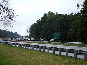
Service areas
- Northbound Welcome Center (Between Exits 2 & 7)
- Fayetteville Rest Areas (Between Exits 46 & 49)
- Selma Rest Areas (Between Exits 98 & 101)
- Rocky Mount Rest Areas (Between Exits 141 & 145)
- Southbound Welcome Center (Between Virginia Border & Exit 180)
History
While returning from a funeral eight days before his 57th birthday, James Raymond Jordan, Sr. (father of NBA star Michael JordanMichael Jordan
Michael Jeffrey Jordan is a former American professional basketball player, active entrepreneur, and majority owner of the Charlotte Bobcats...
) pulled into a rest stop on Interstate 95 to take a nap. Daniel Green (who later changed his name to Lord D.A.A.S. U'Allah)[2] and Larry Martin Demery shot Jordan to death while he slept in his car and proceeded to steal the vehicle. His body was found on August 3 in a Bennettsville, South Carolina swamp, but was not positively identified until August 13
Green and Demery made several calls from Jordan's cell phone and as a result were quickly captured. They had taken other items from the car including two NBA championship rings given to Jordan, Sr. by his son. Demery was wearing a Michael Jordan T-shirt at the time of his arrest. Demery claims that they had planned only to tie up their victim and that Green pulled the trigger for no reason. Both were convicted and sentenced to life imprisonment for this and other violent crimes.
Exit list
{|class="wikitable"|-
!County
!Location
!Exit
!Destinations
!Notes
|-
!colspan=5|Dillon County, South Carolina-Robeson County, North Carolina
Robeson County, North Carolina
Robeson County is a county in the U.S. state of North Carolina. As of 2010 it had a population of 134,168. Since then, it has been one of the 10% of United States counties that were majority-minority; its combined population of American Indian, African American and Latino residents comprise over...
Border
Interstate 95Interstate 95 in South Carolina
Interstate 95 is a major Interstate Highway, running along the East Coast of the United States from Florida to Maine. In South Carolina, I-95 runs approximately parallel to the Atlantic Ocean shore although about inland, from Hardeeville in the south to Dillon in the northeast.-Route...
leaves South Carolina
South Carolina
South Carolina is a state in the Deep South of the United States that borders Georgia to the south, North Carolina to the north, and the Atlantic Ocean to the east. Originally part of the Province of Carolina, the Province of South Carolina was one of the 13 colonies that declared independence...
|-
|rowspan=13|Robeson
Robeson County, North Carolina
Robeson County is a county in the U.S. state of North Carolina. As of 2010 it had a population of 134,168. Since then, it has been one of the 10% of United States counties that were majority-minority; its combined population of American Indian, African American and Latino residents comprise over...
|
|1
|
|Signed as exits 1A (south) and 1B (north) southbound
|-
|
|2
|
|
|-
|
|7
|East Raynham Road – McDonald
McDonald, North Carolina
McDonald is a town in Robeson County, North Carolina, United States. The population was 119 at the 2000 census.-Geography:McDonald is located at ....
, Raynham
Raynham, North Carolina
Raynham is a town in Robeson County, North Carolina, United States. The population was 67 at the 2000 census.-Geography:Raynham is located at ....
|
|-
|
|style="background:#ddffdd"|10
|style="background:#ddffdd"|
|style="background:#ddffdd"|South end of US 301 overlap
|-
|
|13
|
|Signed as exits 13A (east) and 13B (west)
|-
|rowspan=5|Lumberton
Lumberton, North Carolina
Lumberton is a city in Robeson County, North Carolina, United States. The population was 20,795 at the 2000 census. It is the county seat of Robeson County. Lumberton, located in southern North Carolina's Inner Banks region, is located on the Lumber River...
|17
|
|
|-
!colspan=3|Bridge across the Lumber River
Lumber River
The Lumber River is a river in south-central North Carolina in the flat Coastal Plain. European settlers first called the river Drowning Creek, which still is the name of its headwater. The waterway known as the Lumber River extends downstream from the Scotland County-Hoke County border to the...
|-
|19
|Carthage Road
|
|-
|20
|
|
|-
|style="background:#ddffdd"|22
|style="background:#ddffdd"|
|style="background:#ddffdd"|North end of US 301 overlap
|-
|
|25
|
|
|-
|rowspan=2|St. Pauls
St. Pauls, North Carolina
St. Pauls is a town in Robeson County, North Carolina, United States. The population was 2,137 at the 2000 census.-History:The town of St. Pauls was built up around St. Pauls Presbyterian Church which was built on land donated in 1799 by William Davis. St. Pauls grew slowly from a town of just the...
|31
|
|
|-
|33
|
|
|-
|rowspan=12|Cumberland
Cumberland County, North Carolina
-Demographics:As of the census of 2000, there were 302,963 people, 107,358 households, and 77,619 families residing in the county. The population density was 464 people per square mile . There were 118,425 housing units at an average density of 181 per square mile...
|Hope Mills
Hope Mills, North Carolina
Hope Mills is a town in Cumberland County, North Carolina, United States. The population was 15,176 at the 2010 census.-Geography:Hope Mills is located at ....
|40
|
|
|-
|
|41
|
|
|-
|
|44
|Snow Hill Road – Fayetteville Regional Airport
Fayetteville Regional Airport
Fayetteville Regional Airport , also known as Grannis Field, is a public airport located three miles south of the central business district of Fayetteville, a city in Cumberland County, North Carolina, USA....
|
|-
|
|46
|
|Signed as exits 46A (south) and 46B (north)
|-
|
!colspan=3|Bridge across the Cape Fear River
Cape Fear River
The Cape Fear River is a long blackwater river in east central North Carolina in the United States. It flows into the Atlantic Ocean near Cape Fear, from which it takes its name. The overall water quality of the river is continuously measured and monitored by and conducted by the , , and the...
|-
|rowspan=5|Fayetteville
Fayetteville, North Carolina
Fayetteville is a city located in Cumberland County, North Carolina, United States. It is the county seat of Cumberland County, and is best known as the home of Fort Bragg, a U.S. Army post located northwest of the city....
|49
|
|
|-
|52
|
|Signed as exits 52A (east) and 52B (west)
|-
|55
|Murphy Road
|
|-
|56
|
|
|-
|58
|
|
|-
|
|61
|Wade-Steadman Road – Wade
Wade, North Carolina
Wade is a town in Cumberland County, North Carolina, United States. The population was 480 at the 2000 census.-Geography:Wade is located at ....
|
|-
|
|65
|
|
|-
|rowspan=6|Harnett
Harnett County, North Carolina
-Demographics:As of the census of 2000, there were 91,025 people, 33,800 households, and 24,099 families residing in the county. The population density was 153 people per square mile . There were 38,605 housing units at an average density of 65 per square mile...
|
|70
|Bud Hawkins Road
|
|-
|
|71
|Long Branch Road
|
|-
|rowspan=2|Dunn
Dunn, North Carolina
Dunn is a city in Harnett County, North Carolina, United States. The population was 9,196 at the 2000 census.It is the birthplace of early an rock and roll guitar player, Link Wray, and General William C. Lee, father of the American Army Airborne. The city's slogan is "It's all right here." The...
|72
|Pope Road
|
|-
|73
|
|
|-
|
|75
|Jonesboro Road
|
|-
|
|77
|Hodges Chapel Road
|
|-
|rowspan=14|Johnston
Johnston County, North Carolina
-Major highways:* Interstate 40* Interstate 95* U.S. Highway 70* U.S. Highway 301* U.S. Highway 701-Demographics:As of the census of 2000, there were 121,965 people, 46,595 households, and 33,688 families residing in the county. The population density was 154 people per square mile . There were...
|Benson
Benson, North Carolina
Benson is a town located in Johnston County, North Carolina. The town lies at the intersection of Interstates 95 and 40. Each year Benson celebrates Mule Days the 4th Saturday of September, a festival that attracts over 60,000 people each year...
|79
|
|
|-
|
|81
|
|Signed as exits 81A (west) and 81B (east) southbound
|-
|rowspan=2|Four Oaks
Four Oaks, North Carolina
Four Oaks is a town in Johnston County, North Carolina, United States. The population was 1,818 at the 2007 census.-History:Four Oaks was named by Colonel R. R. Bridgers in 1886 for an unusual sight that graced the land upon which he found himself. In 1850, 37 years before there was a town of Four...
|87
|Keen Road – Four Oaks
Four Oaks, North Carolina
Four Oaks is a town in Johnston County, North Carolina, United States. The population was 1,818 at the 2007 census.-History:Four Oaks was named by Colonel R. R. Bridgers in 1886 for an unusual sight that graced the land upon which he found himself. In 1850, 37 years before there was a town of Four...
|
|-
|90
|
|
|-
|
!colspan=3|Bridge across the Neuse River
Neuse River
The Neuse River is a river rising in the Piedmont of North Carolina and emptying into Pamlico Sound below New Bern. Its total length is approximately , making it the longest river entirely contained in North Carolina. The Trent River joins it at New Bern. Its drainage basin, measuring in area,...
|-
|rowspan=2|Smithfield
Smithfield, North Carolina
Smithfield is a town in Johnston County, North Carolina, United States. In 2008, the estimated population was 12,965. It is the county seat of Johnston County...
|93
|Brogden Road – Smithfield
Smithfield, North Carolina
Smithfield is a town in Johnston County, North Carolina, United States. In 2008, the estimated population was 12,965. It is the county seat of Johnston County...
|
|-
|95
|
|
|-
|Selma
Selma, North Carolina
Selma is a town in Johnston County, North Carolina, United States. In 2007, the estimated population was 7,008. Selma is located in North Carolina's Inner Banks region.-Geography:Selma is located at ....
|97
|
|
|-
|
|98
|Pine Level-Selma Road – Selma
Selma, North Carolina
Selma is a town in Johnston County, North Carolina, United States. In 2007, the estimated population was 7,008. Selma is located in North Carolina's Inner Banks region.-Geography:Selma is located at ....
|
|-
|
|101
|Pittman Road
|
|-
|Micro
Micro, North Carolina
Micro is a town in Johnston County, North Carolina, United States. The 2008 estimated population was 537.-Geography:Micro is located at .According to the United States Census Bureau, the town has a total area of , all of it land....
|102
|East Main Street – Micro
Micro, North Carolina
Micro is a town in Johnston County, North Carolina, United States. The 2008 estimated population was 537.-Geography:Micro is located at .According to the United States Census Bureau, the town has a total area of , all of it land....
|
|-
|
|105
|Bagley Road
|
|-
|
|106
|Truck Stop Road
|
|-
|
|107
|
|
|-
|rowspan=3|Wilson
Wilson County, North Carolina
-Demographics:As of the census of 2006, there 73,814 people, 28,613 households, and 19,771 families residing in the county. The population density was 199 people per square mile . There were 30,729 housing units at an average density of 83 per square mile...
|rowspan=3|Wilson
Wilson, North Carolina
Wilson is a city and the county seat of Wilson County in the Coastal Plain region of the U.S. state of North Carolina. The 18th largest city in the state, Wilson had a population of 49,167 according to the 2010 census.- Geography :...
|116
|
|
|-
|119
|
|Signed as exits 119A (east/south) and 119B (west)
|-
|121
|
|
|-
|rowspan=7|Nash
Nash County, North Carolina
Nash County is a county located in the U.S. state of North Carolina. It is part of the Rocky Mount, North Carolina, Metropolitan Statistical Area. As of 2000, the population was 87,420. Its county seat is Nashville.- History :...
|
|127
|
|
|-
|
!colspan=3|Bridge across the Tar River
Tar River
The Tar River is a river that is approximately long, of northeast North Carolina flowing generally southeast to an estuary of Pamlico Sound. The Tar River becomes the tidal Pamlico River once it underpasses the U.S...
|-
|
|
|Sunset Avenue
|In planning stages with construction scheduled for 2019.
|-
|Rocky Mount
Rocky Mount, North Carolina
Rocky Mount is an All-America City Award-winning city in Edgecombe and Nash counties in the coastal plains of the state of North Carolina. Although it was not formally incorporated until February 28, 1867, the North Carolina community that became the city of Rocky Mount dates from the beginning of...
|138
|
|Signed as exits 138A (west) 138B (east)
|-
|Dortches
Dortches, North Carolina
Dortches is a town in Nash County, North Carolina, United States. It is part of the Rocky Mount, North Carolina Metropolitan Statistical Area. The population was 871 in 2008.-Geography:Dortches is located at ....
|141
|
|
|-
|
|145
|
|
|-
|
|150
|
|
|-
|rowspan=6|Halifax
Halifax County, North Carolina
-Demographics:-Demographics:-Demographics:-Demographics:-Demographics:-Demographics:-Demographics:-Demographics:-Demographics:[[Image:HalifaxCountyCotton.wmg.jpg|left|thumb|A cotton field blooms in Halifax County....
|
|154
|
|
|-
|
|160
|
|
|-
|
|168
|
|
|-
|rowspan=2|Roanoke Rapids
Roanoke Rapids, North Carolina
Roanoke Rapids is a city in Halifax County, North Carolina, United States. The population was 16,957 at the 2000 census. It is the principal city of the Roanoke Rapids Micropolitan Statistical Area.-Geography:...
|171
|
|
|-
|173
|
|
|-
|rowspan=2|
!rowspan=2 colspan=3|Bridge across the Roanoke River
Roanoke River
The Roanoke River is a river in southern Virginia and northeastern North Carolina in the United States, 410 mi long. A major river of the southeastern United States, it drains a largely rural area of the coastal plain from the eastern edge of the Appalachian Mountains southeast across the Piedmont...
(Lake Gaston
Lake Gaston
Lake Gaston is a hydroelectric reservoir in east United States of America. Part of the lake is in the North Carolina counties of Halifax, Northampton, and Warren. The part extending into Virginia lies in Brunswick and Mecklenburg counties...
)
|-
|rowspan=3|Northampton
Northampton County, North Carolina
-Demographics:As of the census of 2000, there were 22,086 people, 8,691 households, and 5,953 families residing in the county. The population density was 41 people per square mile . There were 10,455 housing units at an average density of 20 per square mile...
|-
|rowspan=2|Gaston
Gaston, North Carolina
Gaston is a town in Northampton County, North Carolina, United States. The population was 973 at the 2000 census. It is part of the Roanoke Rapids, North Carolina Micropolitan Statistical Area.-Geography:Gaston is located at ....
|176
|
|
|-
|180
|
|
|-
!colspan=5|Northampton County, North Carolina
Northampton County, North Carolina
-Demographics:As of the census of 2000, there were 22,086 people, 8,691 households, and 5,953 families residing in the county. The population density was 41 people per square mile . There were 10,455 housing units at an average density of 20 per square mile...
-Greensville County, Virginia
Greensville County, Virginia
As of the census of 2000, there were 11,560 people, 3,375 households, and 2,396 families residing in the county. The population density was 39 people per square mile . There were 3,765 housing units at an average density of 13 per square mile...
Border
Interstate 95 continues north into VirginiaInterstate 95 in Virginia
In the Commonwealth of Virginia, Interstate 95 runs through the state. It runs concurrently for with Interstate 64 in Richmond, and meets the northern terminus of Interstate 85 in Petersburg. Though Interstate 95 was originally planned to go straight through Washington, D.C., it was instead...