
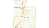
Interstate 15 in Utah
Encyclopedia
In the U.S. state
of Utah
, Interstate 15 runs north–south through the southwestern and central portions of the state, passing through many of the population centers of that state, including St. George
, Provo
, Salt Lake City
, and Ogden
, the latter three being part of the urban area known as the Wasatch Front
. It is the primary north–south highway in Utah, as the majority of the state's population lives along its corridor. The only Metropolitan Statistical Area in Utah not connected via I-15 is the Logan Utah-Idaho Metropolitan Statistical Area
.
region, which includes St. George
, Cedar City
, and eventually most of the major cities and suburbs along the Wasatch Front
, including Provo
, Orem
, Sandy
, West Jordan
, Salt Lake City
, Layton
, and Ogden
. Around Cove Fort
, Interstate 70 begins its journey eastward across the country. The interstate merges
with I-80 for about 3 miles (5 km) from South Salt Lake
to just west of Downtown Salt Lake City
and also merges with Interstate 84 from Ogden
to Tremonton
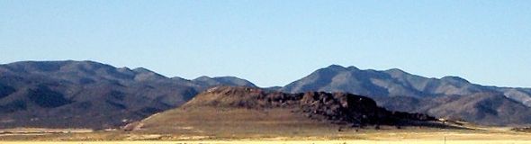
. Along nearly its entire length through the state, I-15 winds its way along the western edge of a nearly continuous range of mountains (the Wasatch Range
in the northern half of the state). The only exceptions are when it passes through the mountains south of Cedar City
and again north of Cove Fort
.
 I-15 begins at the Arizona
/Utah
border
and heads northeast, continuing with two lanes in each direction. Right past the border, there is a port of entry
on each side, making the first exit on the interstate in Utah going northbound. The route turns north past Bloomington
before turning northeast again after the interchange with SR-18 to pass the eastern side of St. George
. The highway continues northeast after exiting St. George and turns north-northeast north of Toquerville
. South of Cedar City
, the route turns east and north to pass through the west side of Cedar City and turns northeast again. Past a ranch exit (exit 100), the interstate turns northwest and then north to enter the western side of Beaver
, with two interchanges serving that town. The road continues in a general north-northeast direction before intersecting with the western terminus of I-70. Past I-70, the route meanders to the north and northeast before straightening out to the northeast southwest of Kanosh
. The highway passes the east side of both Meadow
and Fillmore
and the west side of Holden
. The route turns north briefly after bypassing Scipio
to the east before turning northeast. Past the interchange with SR-28 (which serves as a connector to I-70 for southbound I-15 motorists), the road passes the eastern side of Nephi
. The interstate then turns northwest and north, bypassing Mona
to the east.
 The highway enters the Wasatch Front
and the Provo-Orem metropolitan area
as it turns northeast and enters the town of Santaquin
, where US-6 begins its overlap with I-15. Exiting Santaquin, the highway turns north and then northeast again to enter Payson
. Continuing northeast, the route enters Spanish Fork
and intersects with US-6 on the north side of town, where it turns north and gains one lane in each direction, the first time the interstate widens in the state. This interchange also marks the northern end end of the overlap with US-6. The route passes the west side of Springville
and turns northwest south of Provo
. The highway enters Provo and intersects with the southern terminus of US-189. Past this point, the interstate widens to four lanes in each direction. The route continues northwest, bisecting the west side of Provo. Past SR-114, the road loses one lane in each direction. Past SR-265, the highway once again widens to four lanes in each direction and gains an HOV lane begins. The lane gain is temporary and when the route turns north, the fourth lane is lost. At this point, the highway exits Provo and enters Orem
. Right before the interchange at SR-241, the route turns northwest, entering Lindon
. The route then exits Lindon and enters the south side American Fork
, meandering between the west-northwest and northwest. The route straightens out the northwest and enters Lehi
. In Lehi, US-89 begins an overlap with I-15. Past Lehi, the interstate exits the Provo metropolitan area and Utah County
to enter the Salt Lake City metropolitan area
.
 As the route enters the Salt Lake Valley
from only one of three other points connecting Salt Lake County and Utah County (the others being SR-68 and Traverse Ridge Road), it turns northeast. Past SR-140, the highway widens to four lanes in each direction (not including the HOV lane) and turns north. The route enters Draper
and turns north-northwest past SR-71, where US-89 ends its overlap with the interstate. As it enters Sandy
, the interstate widens to five lanes past SR-151. The route straightens out to the north. The route turns north-northwest past SR-209 and soon after enters Midvale
. The route intersects I-215, a beltway running through many of Salt Lake City's suburbs, in Murray. Past this interchange, the route heads north and enters Murray
. The route exits Murray and enters South Salt Lake
, where an interchange with I-80 and SR-201 is located, colloquially known as the "Spaghetti Bowl". The southern overlap of I-80 begins at this point. Also at this point, the highway enters Salt Lake City
and a collector/distributor road begins at either side of the interstate, providing an exit to SR-201, 1300 South, and SR-270. After the collector-distributor ends, the route turns northwest to bypass downtown Salt Lake City
. The route turns north after SR-269 and the northern end of the I-80 overlap. Past this point, the HOV lane ends and the highway loses one lane in each direction. Past the single-point urban interchange
at SR-268, the interstate turns northwest and loses another lane. Before US-89, the road turns northeast briefly before turning north and entering Davis County
.
The road enters North Salt Lake
and I-215 defaults onto I-15 northbound. The route then gains two lanes in each direction and turns northeast. Past 2600 South, the highway turns north and enters Woods Cross
to the west and Bountiful
to the east. In West Bountiful
, US-89 begins another overlap with I-15. The highway continues north and enters Centerville
. The route exits Centerville and enters Farmington
and turns northwest, US-89 exiting on its own separate freeway at an interchange (where the Legacy Parkway
terminates). The route passes through Kaysville
, Layton
, and Clearfield
before turning north, passing the west side of Hill Air Force Base
. The road continues north through Sunset
before turning northeast through Roy
. The interstate exits Davis County and enters Weber County
. In Roy, I-84 defaults onto I-15 northbound and an overlap begins. The highway enters Ogden
and the Ogden-Hinckley Airport
is located on the west side of the highway. Past the airport, the route turns northwest before exiting Ogden and entering Marriott-Slaterville
, where it straightens out to the north. Past Farr West
, the highway turns northwest briefly before turning north and exiting Weber County
, the Ogden-Clearfield metropolitan area
, and the Wasatch Front
.
 The interstate continues north through Box Elder County
. Brigham City
, the county seat
, is bypassed to the west by the freeway. Past US-91 (which continues to Logan
and points northward), the route turns northwest to Tremonton
, where I-84 separates, continuing northwest, and I-15 turns north. The freeway continues in this general direction until the Idaho
border. The last exit northbound is located at exit 398, 25800 North, which provides a connection to the town of Portage
.

The southwest-north alignment followed by I-15 was a major transportation corridor in the early 20th century, followed by auto trails such as the Arrowhead Trail (south from Salt Lake City), Evergreen National Highway (entire length), and Banff-Grand Canyon Road (north from Nephi). In 1926, when the numbered system of U.S. highways was created, this route was signed U.S. Route 91
The route of I-15 from St. George
to Brigham City
was built along the corridor of what was U.S. Route 91 from 1926-1974. In 1974 I-15 was reasonably intact and US-91 was deleted, with the unfinished segments signed as Temporary I-15. The route north of Brigham City was built along the corridor of an old route of U.S. Route 191. This highway was also deleted once I-15 was reasonably intact. However, a different route in Utah was re-designated US-191 in 1982.
Prior to 1977 the route of I-15 (and US-91 before) was also designated State Route 1 by the state of Utah, but no portion of the route was signed with this number.
In January 2009, the speed limit on two sections of I-15 together totaling 34 miles was raised to 80 mph as a "test," making Utah the second state to currently have speed limits greater than 75 mph.
|rowspan=16|Washington
|rowspan=4|St. George
|2.135
|
|2
|
|
|-
|4.641
|
|4
|Brigham Road
|
|-
|6.311
|
|6
|
|
|-
|8.662
|
|8
|
|
|-
|rowspan=3|Washington
|10.901
|
|10
|Washington City (SR-212)
|
|-
|13.378
|
|13
|Washington Parkway
|
|-
|15.908
|
|16
|
|
|-
|rowspan=2|Leeds
|22.579
|
|22
|Leeds
, Silver Reef
(SR-228)
|Northbound exit and southbound entrance
|-
|23.703
|
|23
|Leeds
, Silver Reef
(SR-228)
|Southbound exit and northbound entrance
|-
|Toquerville
|27.470
|
|27
|
|
|-
|
|30.682
|
|30
|Browse
|
|-
|
|31.861
|
|31
|Pintura
|
|-
|
|33.435
|
|33
|Ranch exit
|
|-
|
|36.763
|
|36
|Ranch exit
|
|-
|
|40.253
|
|40
|Kolob Canyons
(Zion National Park
)
|
|-
|
|42.159
|
|42
|New Harmony
, Kanarraville
|Former SR-58
|-
|rowspan=10|Iron
|
|51.149
|
|51
|Hamilton Fort
, Kanarraville
|Former SR-58
|-
|rowspan=3|Cedar City
|56.804
|
|57
|
|
|-
|58.837
|
|59
|
|
|-
|62.497
|
|62
|
|
|-
|
|70.263
|
|71
|Summit
, Enoch
|Former SR-38
|-
|rowspan=2|Parowan
|75.205
|
|75
|
|
|-
|77.801
|
|78
|
|
|-
|
|82.253
|
|82
|
|
|-
|
|94.453
|
|95
|
|
|-
|
|99.690
|
|100
|Ranch exit
|
|-
|rowspan=5|Beaver
|
|108.745
|
|109
|
|
|-
|Beaver
|111.780
|
|112
|
|
|-
|
|120.126
|
|120
|Manderfield
|
|-bgcolor=e7e7e7
|
|
|
|125
|Ranch exit
|Closed
|-
|
|129.443
|
|129
|Sulphurdale
|
|-
|rowspan=11|Millard
|
|132.183
|
|132
|, Denver
|
|-
|
|134.875
|
|135
|Historic Cove Fort (SR-161)
|
|-
|
|138.073
|
|138
|Ranch exit
|
|-
|
|146.493
|
|146
|Kanosh
|Former SR-133
|-
|Meadow
|158.265
|
|158
|
|
|-
|rowspan=2|Fillmore
|163.370
|
|163
|
|
|-
|166.723
|
|167
|
|
|-
|
|173.507
|
|174
|
|
|-
|
|178.330
|
|178
|
|South end of US-50 overlap
|-
|
|183.638
|
|184
|Ranch exit
|
|-
|
|188.439
|
|188
|
|North end of US-50 overlap
|-
|rowspan=6|Juab
|
|202.189
|
|202
|Yuba Lake
|
|-
|
|206.553
|
|207
|Mills, Levan
(SR-78)
|
|-
|rowspan=2|Nephi
|222.812
|
|222
|
|
|-
|225.266
|
|225
|
|
|-
|
|228.091
|
|228
|
|
|-
|
|233.161
|236
|233
|
|
|-
|rowspan=21|Utah
|rowspan=2|Santaquin
|242.447
|245
|242
|South Santaquin
|
|-
|244.809
|248
|244
|
|South end of US-6 overlap
|-
|rowspan=2|Payson
|248.845
|252
|248
|Payson
, Salem
(SR-178)
|
|-
|250.923
|254
|250
|
|
|-
|
|253.557
|256
|253
|
|
|-
|rowspan=2|Spanish Fork
|257.264
|260
|257
|
|
|-
|257.636
|261
|258
|
|North end of US-6 overlap; northbound exit is via exit 257
|-
|rowspan=2|Springville
|259.976
|263
|260
|
|
|-
|261.821
|265
|261
|
|
|-
|rowspan=2|Provo
|263.373
|266
|263
|
|
|-
|265.589
|268
|265
|
|Signed as exits 265A (east) and 265B (west) northbound
|-
|rowspan=3|Orem
|269.072
|272
|269
|
|
|-
|270.660
|274
|271
|Center Street – Orem
|
|-
|271.670
|275
|272
|
|
|-
|Lindon
|272.767
|276
|273
|1600 North (SR-241) – Lindon
|
|-
|Pleasant Grove
|275.328
|278
|275
|Pleasant Grove
, Lindon
|Near the Sam White Bridge
|-
|rowspan=2|American Fork
|276.501
|279
|276
|500 East (SR-180) – American Fork
, Pleasant Grove
|
|-
|278.586
|281
|278
|Main Street (SR-145) – American Fork
|
|-
|rowspan=3|Lehi
|279.701
|282
|279
|
|
|-
|282.311
|285
|282
|
|South end of US-89 overlap
|-
|283.985
|287
|284
|
|
|-
|rowspan=23|Salt Lake
|rowspan=3|Draper
|288.272
|291
|288
|
|
|-
|289.832
|293
|289
|
|
|-
|291.358
|294
|291
|
|North end of US-89 overlap
|-
|rowspan=3|Sandy
|292.612
|
|292
|
|Opened late 2010
|-
|293.634
|297
|293
|
|
|-
|295.616
|298
|295
|
|
|-
|Midvale
|297.920
|301
|297
|
|
|-
|rowspan=3|Murray
|299.005
|302
|298
|
|
|-
|300.300
|303
|300
|
|
|-
|301.653
|304
|301
|
|
|-
|rowspan=4|South Salt Lake
|303.414
|306
|303
|
|
|-
|304.691
|307
|304
| – Cheyenne
|South end of I-80 overlap
|-
|305.231
|308A
|305A
|
|
|-
|305.198
|308B
|305B
|2100 South (SR-201)
|
|-
|rowspan=9|Salt Lake City
|306.315
|309A
|305C
|1300 South
|
|-
|306.607
|309B
|305D
|900 South (SR-270)
|Northbound exit and southbound entrance
|-
|307.500
|310
|306
|600 South (SR-269)
|Northbound exit and southbound entrance
|-
|307.740
|310
|307
|400 South
|Northbound exit and southbound entrance are HOV
-only
|-
|308.079
|311
|308
|, Reno
|North end of I-80 overlap
|-
|309.333
|312
|309
|600 North (SR-268)
|
|-
|310.239
|313
|310
|1000 North
|No northbound exit
|-
|311.792
|314
|311
|2300 North – Warm Springs Road
|
|-
|311.947
|315
|312
|
|Southbound exit and northbound entrance
|-
|rowspan=22|Davis
|rowspan=4|North Salt Lake
|313.128
|315
|312
|
|Northbound exit and southbound entrance
|-
|313.275
|316
|313
|
|Southbound exit and northbound entrance
|-
|314.301
|317
|314
|Center Street
|Southbound exit only
|-
|rowspan=2|315.243
|rowspan=2|318
|rowspan=2|315
|rowspan=2|2600 South (SR-93)
|rowspan=2|
|-
|rowspan=2|Woods Cross
|-
|rowspan=3|316.870
|rowspan=3|320
|rowspan=3|316
|rowspan=3|
|rowspan=3|
|-
|Bountiful
|-
|rowspan=3|West Bountiful
|-
|317.557
|321
|317
|400 North (SR-106)
|Northbound exit and southbound entrance
|-
|rowspan=2|318.024
|rowspan=2|321
|rowspan=2|317
|rowspan=2|
|rowspan=2|South end of US-89 overlap; southbound exit and northbound entrance
|-
|Bountiful
|-
|Centerville
|319.512
|322
|319
|Centerville
(SR-105)
|
|-
|rowspan=4|Farmington
|322.916
|325
|322
|
|Northbound exit and southbound entrance
|-
|324.026
|326
|324
|
|North end of US-89 overlap; northbound exit and southbound entrance
|-
|324.243
|
|
|Legacy Parkway
|Southbound exit and northbound entrance
|-
|324.741
|327
|325
|
|Northbound exit is via exit 324
|-
|Kaysville
|328.640
|331
|328
|
|
|-
|rowspan=3|Layton
|330.019
|332
|330
|
|Northbound exit and southbound entrance
|-
|331.589
|334
|331
|
|
|-
|332.883
|335
|332
|– Antelope Island
|
|-
|rowspan=2|Clearfield
|334.066
|336
|334
|
|
|-
|335.800
|338
|335
|
|
|-
|rowspan=9|Weber
|Roy
|338.447
|341
|338
|
|
|-
|rowspan=2|Riverdale
|339.133
|342
|339
|
|Northbound exit and southbound entrance
|-
|340.227
|343
|340
|, Cheyenne
|South end of I-84 overlap; northbound exit is via exit 339
|-
|rowspan=2|Ogden
|341.948
|344
|341
|
|
|-
|343.067
|345
|342
|
|Northbound exit and southbound entrance
|-
|West Haven
|343.852
|346
|343
|
|
|-
|rowspan=2|Marriott-Slaterville
|344.968
|347
|344
|
|
|-
|346.726
|349
|346
|400 North
|
|-
|Farr West
|349.361
|352
|349
|
|
|-
|rowspan=14|Box Elder
|
|351.853
|354
|351
|
|
|-
|rowspan=4|Willard
|357.554
|360
|357
|
|
|-
|358.566
|361
|
|Port of Entry
|
|-
|360.542
|363
|
|Rest Area
|Northbound exit and entrance
|-
|362.020
|364
|362
|
|
|-
|rowspan=2|Brigham City
|363.738
|366
|363
|Forest Street
|
|-
|365.508
|368
|365
|
|
|-
|Honeyville
|372.734
|375
|372
|
|
|-
|Tremonton
|376.532
|379
|376
|
|
|-
|
|379.334
|382
|379
|, Boise
|North end of I-84 overlap; south end of SR-30 overlap
|-
|Tremonton
|381.037
|383
|381
|
|
|-
|
|385.266
|387
|385
|
|North end of SR-30 overlap
|-
|
|392.387
|394
|392
|
|
|-
|
|398.817
|402
|398
|Portage
|Former SR-90
U.S. state
A U.S. state is any one of the 50 federated states of the United States of America that share sovereignty with the federal government. Because of this shared sovereignty, an American is a citizen both of the federal entity and of his or her state of domicile. Four states use the official title of...
of Utah
Utah
Utah is a state in the Western United States. It was the 45th state to join the Union, on January 4, 1896. Approximately 80% of Utah's 2,763,885 people live along the Wasatch Front, centering on Salt Lake City. This leaves vast expanses of the state nearly uninhabited, making the population the...
, Interstate 15 runs north–south through the southwestern and central portions of the state, passing through many of the population centers of that state, including St. George
St. George, Utah
St. George is a city located in the southwestern part of the U.S. state of Utah, and the county seat of Washington County, Utah. It is the principal city of and is included in the St. George, Utah, Metropolitan Statistical Area. The city is 119 miles northeast of Las Vegas, Nevada, and 303 miles ...
, Provo
Provo, Utah
Provo is the third largest city in the U.S. state of Utah, located about south of Salt Lake City along the Wasatch Front. Provo is the county seat of Utah County and lies between the cities of Orem to the north and Springville to the south...
, Salt Lake City
Salt Lake City, Utah
Salt Lake City is the capital and the most populous city of the U.S. state of Utah. The name of the city is often shortened to Salt Lake or SLC. With a population of 186,440 as of the 2010 Census, the city lies in the Salt Lake City metropolitan area, which has a total population of 1,124,197...
, and Ogden
Ogden, Utah
Ogden is a city in Weber County, Utah, United States. Ogden serves as the county seat of Weber County. The population was 82,825 according to the 2010 Census. The city served as a major railway hub through much of its history, and still handles a great deal of freight rail traffic which makes it a...
, the latter three being part of the urban area known as the Wasatch Front
Wasatch Front
The Wasatch Front is a metropolitan region in the north-central part of the U.S. state of Utah. It consists of a chain of cities and towns stretched along the Wasatch Range from approximately Santaquin in the south to Brigham City in the north...
. It is the primary north–south highway in Utah, as the majority of the state's population lives along its corridor. The only Metropolitan Statistical Area in Utah not connected via I-15 is the Logan Utah-Idaho Metropolitan Statistical Area
Logan, Utah
-Layout of the City:Logan's city grid originates from its Main and Center Street block, with Main Street running north and south, and Center east and west. Each block north, east, south, or west of the origin accumulates in additions of 100 , though some streets have non-numeric names...
.
Route description
The interstate passes through the fast-growing DixieDixie (Utah)
Dixie is the nickname for southwestern Utah. It was first settled in the early 1860s, when farmers were sent south by Brigham Young to grow cotton, hoping to capitalize on the lack of availability of cotton due to the American Civil War. St. George, Grafton, Duncans Retreat, Adventure, and Northup...
region, which includes St. George
St. George, Utah
St. George is a city located in the southwestern part of the U.S. state of Utah, and the county seat of Washington County, Utah. It is the principal city of and is included in the St. George, Utah, Metropolitan Statistical Area. The city is 119 miles northeast of Las Vegas, Nevada, and 303 miles ...
, Cedar City
Cedar City, Utah
As of the census of 2000, there were 20,527 people, 6,486 households, and 4,682 families residing in the city. The population density was 1,021.8 people per square mile . There were 7,109 housing units at an average density of 353.9 per square mile...
, and eventually most of the major cities and suburbs along the Wasatch Front
Wasatch Front
The Wasatch Front is a metropolitan region in the north-central part of the U.S. state of Utah. It consists of a chain of cities and towns stretched along the Wasatch Range from approximately Santaquin in the south to Brigham City in the north...
, including Provo
Provo, Utah
Provo is the third largest city in the U.S. state of Utah, located about south of Salt Lake City along the Wasatch Front. Provo is the county seat of Utah County and lies between the cities of Orem to the north and Springville to the south...
, Orem
Orem, Utah
Orem is a city in Utah County, Utah, United States, in the north-central part of the state. It is adjacent to Provo, Lindon, and Vineyard and is about south of Salt Lake City. Orem is one of the principal cities of the Provo-Orem, Utah Metropolitan Statistical Area, which includes all of Utah and...
, Sandy
Sandy, Utah
Sandy is a city in Salt Lake County, Utah, United States. It is a suburb of Salt Lake City. The population was 87,461 at the 2010 census, making it the sixth-largest city in Utah....
, West Jordan
West Jordan, Utah
West Jordan is a city in Salt Lake County, Utah, United States. West Jordan is a rapidly growing suburb of Salt Lake City and has a mixed economy. According to the 2010 Census, the city had a population of 103,712, placing it as the fourth most populated in the state. The city occupies the...
, Salt Lake City
Salt Lake City, Utah
Salt Lake City is the capital and the most populous city of the U.S. state of Utah. The name of the city is often shortened to Salt Lake or SLC. With a population of 186,440 as of the 2010 Census, the city lies in the Salt Lake City metropolitan area, which has a total population of 1,124,197...
, Layton
Layton, Utah
-External links:*...
, and Ogden
Ogden, Utah
Ogden is a city in Weber County, Utah, United States. Ogden serves as the county seat of Weber County. The population was 82,825 according to the 2010 Census. The city served as a major railway hub through much of its history, and still handles a great deal of freight rail traffic which makes it a...
. Around Cove Fort
Cove Fort, Utah
Cove Fort is a fort and historical site located in Millard County, Utah. It was founded in 1867 by Ira Hinckley at the request of Brigham Young. One of its distinctive features is the use of volcanic rock in the construction of the walls, rather than the wood used in many mid-19th century...
, Interstate 70 begins its journey eastward across the country. The interstate merges
Concurrency (road)
A concurrency, overlap, or coincidence in a road network is an instance of one physical road bearing two or more different highway, motorway, or other route numbers...
with I-80 for about 3 miles (5 km) from South Salt Lake
South Salt Lake, Utah
South Salt Lake is a city in Salt Lake County, Utah, United States, part of the Salt Lake City, Utah Metropolitan Statistical Area. The population was 23,617 at the 2010 census.-History:...
to just west of Downtown Salt Lake City
Downtown Salt Lake City
Downtown is the oldest district in Salt Lake City. The grid from which the entire city is laid out originates at Temple Square, the location of the Salt Lake Temple.-Location:...
and also merges with Interstate 84 from Ogden
Ogden, Utah
Ogden is a city in Weber County, Utah, United States. Ogden serves as the county seat of Weber County. The population was 82,825 according to the 2010 Census. The city served as a major railway hub through much of its history, and still handles a great deal of freight rail traffic which makes it a...
to Tremonton
Tremonton, Utah
Tremonton is a city in Box Elder County, Utah, United States. The population was 7,647 at the 2010 census.-Geography:Tremonton is located at ....
. Along nearly its entire length through the state, I-15 winds its way along the western edge of a nearly continuous range of mountains (the Wasatch Range
Wasatch Range
The Wasatch Range is a mountain range that stretches approximately from the Utah-Idaho border, south through central Utah in the western United States. It is generally considered the western edge of the greater Rocky Mountains, and the eastern edge of the Great Basin region...
in the northern half of the state). The only exceptions are when it passes through the mountains south of Cedar City
Cedar City, Utah
As of the census of 2000, there were 20,527 people, 6,486 households, and 4,682 families residing in the city. The population density was 1,021.8 people per square mile . There were 7,109 housing units at an average density of 353.9 per square mile...
and again north of Cove Fort
Cove Fort, Utah
Cove Fort is a fort and historical site located in Millard County, Utah. It was founded in 1867 by Ira Hinckley at the request of Brigham Young. One of its distinctive features is the use of volcanic rock in the construction of the walls, rather than the wood used in many mid-19th century...
.
Arizona
Arizona ; is a state located in the southwestern region of the United States. It is also part of the western United States and the mountain west. The capital and largest city is Phoenix...
/Utah
Utah
Utah is a state in the Western United States. It was the 45th state to join the Union, on January 4, 1896. Approximately 80% of Utah's 2,763,885 people live along the Wasatch Front, centering on Salt Lake City. This leaves vast expanses of the state nearly uninhabited, making the population the...
border
Border
Borders define geographic boundaries of political entities or legal jurisdictions, such as governments, sovereign states, federated states and other subnational entities. Some borders—such as a state's internal administrative borders, or inter-state borders within the Schengen Area—are open and...
and heads northeast, continuing with two lanes in each direction. Right past the border, there is a port of entry
Port of entry
In general, a port of entry is a place where one may lawfully enter a country. It typically has a staff of people who check passports and visas and inspect luggage to assure that contraband is not imported. International airports are usually ports of entry, as are road and rail crossings on a...
on each side, making the first exit on the interstate in Utah going northbound. The route turns north past Bloomington
Bloomington, Utah
Bloomington is a populated place in Washington County, Utah, United States, which now forms part of the city of St. George, as a suburb.Access to Bloomington is achieved by "Exit 4" on Interstate 15, or by Tonaquint Drive on the North side of the "Bloomington Circle", a loop that encircles the...
before turning northeast again after the interchange with SR-18 to pass the eastern side of St. George
St. George, Utah
St. George is a city located in the southwestern part of the U.S. state of Utah, and the county seat of Washington County, Utah. It is the principal city of and is included in the St. George, Utah, Metropolitan Statistical Area. The city is 119 miles northeast of Las Vegas, Nevada, and 303 miles ...
. The highway continues northeast after exiting St. George and turns north-northeast north of Toquerville
Toquerville, Utah
Toquerville is a city in Washington County, Utah, United States. The population was 910 at the 2000 census.-Geography:Toquerville is located at ....
. South of Cedar City
Cedar City, Utah
As of the census of 2000, there were 20,527 people, 6,486 households, and 4,682 families residing in the city. The population density was 1,021.8 people per square mile . There were 7,109 housing units at an average density of 353.9 per square mile...
, the route turns east and north to pass through the west side of Cedar City and turns northeast again. Past a ranch exit (exit 100), the interstate turns northwest and then north to enter the western side of Beaver
Beaver, Utah
Beaver is a city in Beaver County, Utah, United States. The population was 2,454 at the 2000 census. It is the county seat of Beaver County.Settled by Mormon pioneers in 1856, Beaver was one of a string of Mormon settlements extending the length of Utah...
, with two interchanges serving that town. The road continues in a general north-northeast direction before intersecting with the western terminus of I-70. Past I-70, the route meanders to the north and northeast before straightening out to the northeast southwest of Kanosh
Kanosh, Utah
Kanosh is a town in Millard County, Utah, United States. The population was 485 at the 2000 census.- Geography :Kanosh is located at ....
. The highway passes the east side of both Meadow
Meadow, Utah
Meadow is a town in Millard County, Utah, United States. The population was 254 at the 2000 census. Originally called Meadow Creek, the town is located about eight miles south of Fillmore.-History:The Meadow Creek was the site where Walkara died in 1855...
and Fillmore
Fillmore, Utah
Fillmore is a city in Millard County, Utah, United States. The population was 2,253 at the 2000 census. It is the county seat of Millard County. It is named for the thirteenth US President Millard Fillmore....
and the west side of Holden
Holden, Utah
Holden is a town in Millard County, Utah, United States. The population was 400 at the 2000 census.-History:Holden was settled in 1855 by a group of ten families sent out by the LDS bishop of Fillmore. It was named for Elijah E...
. The route turns north briefly after bypassing Scipio
Scipio, Utah
Scipio is a town in Millard County, Utah, United States. The population was 290 at the 2000 census.-Geography:Scipio is located at ....
to the east before turning northeast. Past the interchange with SR-28 (which serves as a connector to I-70 for southbound I-15 motorists), the road passes the eastern side of Nephi
Nephi, Utah
Nephi is a city in Juab County, Utah, United States. It is part of the Provo–Orem, Utah Metropolitan Statistical Area. The population was 4,733 at the 2000 census. It is the county seat of Juab County. It was settled by Mormon pioneers in 1851, and is the principal city in Juab Valley, an...
. The interstate then turns northwest and north, bypassing Mona
Mona, Utah
Mona is a city in Juab County, Utah, United States. It is part of the Provo–Orem, Utah Metropolitan Statistical Area. The population was 850 at the 2000 census. At the time this was sufficient under Utah state law for Mona to become a city, which it did at the end of 2000...
to the east.
Wasatch Front
The Wasatch Front is a metropolitan region in the north-central part of the U.S. state of Utah. It consists of a chain of cities and towns stretched along the Wasatch Range from approximately Santaquin in the south to Brigham City in the north...
and the Provo-Orem metropolitan area
Provo-Orem metropolitan area
The Provo-Orem Metropolitan Statistical Area, as defined by the United States Census Bureau, is an area consisting of two counties in Utah, anchored by the cities of Provo and Orem...
as it turns northeast and enters the town of Santaquin
Santaquin, Utah
Santaquin is a city in Utah County, Utah, United States. It is part of the Provo–Orem, Utah Metropolitan Statistical Area. The population was 4,834 at the 2000 census, while the 2008 estimates placed it at 8,400.-Geography:...
, where US-6 begins its overlap with I-15. Exiting Santaquin, the highway turns north and then northeast again to enter Payson
Payson, Utah
Payson is a city in Utah County, Utah, United States. It is part of the Provo–Orem, Utah Metropolitan Statistical Area. The population was 12,716 at the 2000 census. The current mayor is Rick Moore, who in the 2009 election was the first write-in candidate ever to defeat an incumbent mayor in...
. Continuing northeast, the route enters Spanish Fork
Spanish Fork, Utah
Spanish Fork is a city in Utah County, Utah, United States. It is part of the Provo–Orem, Utah Metropolitan Statistical Area. The population was 31,497 as of the 2008 census estimate.-History:Spanish Fork was settled by LDS pioneers in 1851...
and intersects with US-6 on the north side of town, where it turns north and gains one lane in each direction, the first time the interstate widens in the state. This interchange also marks the northern end end of the overlap with US-6. The route passes the west side of Springville
Springville, Utah
Springville is a city in Utah County, Utah, United States. It is part of the Provo–Orem, Utah Metropolitan Statistical Area. The population was 20,424 at the 2000 census, while the 2008 estimates placed it at 28,520. Just minutes south of Provo, Springville is a bedroom community for...
and turns northwest south of Provo
Provo, Utah
Provo is the third largest city in the U.S. state of Utah, located about south of Salt Lake City along the Wasatch Front. Provo is the county seat of Utah County and lies between the cities of Orem to the north and Springville to the south...
. The highway enters Provo and intersects with the southern terminus of US-189. Past this point, the interstate widens to four lanes in each direction. The route continues northwest, bisecting the west side of Provo. Past SR-114, the road loses one lane in each direction. Past SR-265, the highway once again widens to four lanes in each direction and gains an HOV lane begins. The lane gain is temporary and when the route turns north, the fourth lane is lost. At this point, the highway exits Provo and enters Orem
Orem, Utah
Orem is a city in Utah County, Utah, United States, in the north-central part of the state. It is adjacent to Provo, Lindon, and Vineyard and is about south of Salt Lake City. Orem is one of the principal cities of the Provo-Orem, Utah Metropolitan Statistical Area, which includes all of Utah and...
. Right before the interchange at SR-241, the route turns northwest, entering Lindon
Lindon, Utah
Lindon is a city in Utah County, Utah, United States. It is part of the Provo–Orem, Utah Metropolitan Statistical Area. The population was 10,070 at the 2010 census.The western sculptor Grant Speed resides in Lindon.-Geography:...
. The route then exits Lindon and enters the south side American Fork
American Fork, Utah
American Fork is a city in Utah County, Utah, United States, at the foot of Mount Timpanogos in the Wasatch Range, north of Utah Lake. It is part of the Provo–Orem, Utah Metropolitan Statistical Area. The population was 26,263 at the 2010 census, nearly a 20% growth since the 2000 census...
, meandering between the west-northwest and northwest. The route straightens out the northwest and enters Lehi
Lehi, Utah
-Attractions:Lehi Roller MillsLehi Roller Mills was founded in 1906 by a co-op of farmers. George G. Robinson purchased the mill in 1910, and since then it has remained in the family. It is run today by grandson R. Sherman Robinson....
. In Lehi, US-89 begins an overlap with I-15. Past Lehi, the interstate exits the Provo metropolitan area and Utah County
Utah County, Utah
Utah County is a county located in the U.S. state of Utah. As of 2000, the population was 368,536 and by 2008 was estimated at 530,837. It was named for the Spanish name for the Ute Indians. The county seat and largest city is Provo...
to enter the Salt Lake City metropolitan area
Salt Lake City metropolitan area
The Salt Lake City Metropolitan Statistical Area, as defined by the United States Census Bureau, is an area consisting of three counties in north central Utah, anchored by Salt Lake City. As of the 2000 census, the MSA had a population of 968,858. As of July 1, 2009 the U.S...
.
Salt Lake Valley
Salt Lake Valley is a valley in Salt Lake County in the north-central portion of the U.S. state of Utah. It contains Salt Lake City and many of its suburbs, notably West Valley City, Murray, Sandy, and West Jordan; its total population is 1,029,655 as of 2010...
from only one of three other points connecting Salt Lake County and Utah County (the others being SR-68 and Traverse Ridge Road), it turns northeast. Past SR-140, the highway widens to four lanes in each direction (not including the HOV lane) and turns north. The route enters Draper
Draper, Utah
Draper is a city in Salt Lake and Utah Counties in the U.S. state of Utah, located about south of Salt Lake City along the Wasatch Front. Between 1990 and 2000 Draper was Utah's fastest-growing city over 5,000 people . Its population in 1990 was 7,143 and had grown to 25,220 by the 2000 census...
and turns north-northwest past SR-71, where US-89 ends its overlap with the interstate. As it enters Sandy
Sandy, Utah
Sandy is a city in Salt Lake County, Utah, United States. It is a suburb of Salt Lake City. The population was 87,461 at the 2010 census, making it the sixth-largest city in Utah....
, the interstate widens to five lanes past SR-151. The route straightens out to the north. The route turns north-northwest past SR-209 and soon after enters Midvale
Midvale, Utah
Midvale is a city in Salt Lake County, Utah, United States. It is part of the Salt Lake City, Utah Metropolitan Statistical Area. The population was 27,029 at the 2000 census.-Geography:Midvale is located at ....
. The route intersects I-215, a beltway running through many of Salt Lake City's suburbs, in Murray. Past this interchange, the route heads north and enters Murray
Murray, Utah
Murray is a city situated on the Wasatch Front in the core of Salt Lake Valley in the U.S. state of Utah. Named for territorial governor Eli Murray, it is the state's fourteenth largest city. According to the 2010 census, Murray has approximately 46,746 residents.Murray is close to Salt Lake City,...
. The route exits Murray and enters South Salt Lake
South Salt Lake, Utah
South Salt Lake is a city in Salt Lake County, Utah, United States, part of the Salt Lake City, Utah Metropolitan Statistical Area. The population was 23,617 at the 2010 census.-History:...
, where an interchange with I-80 and SR-201 is located, colloquially known as the "Spaghetti Bowl". The southern overlap of I-80 begins at this point. Also at this point, the highway enters Salt Lake City
Salt Lake City, Utah
Salt Lake City is the capital and the most populous city of the U.S. state of Utah. The name of the city is often shortened to Salt Lake or SLC. With a population of 186,440 as of the 2010 Census, the city lies in the Salt Lake City metropolitan area, which has a total population of 1,124,197...
and a collector/distributor road begins at either side of the interstate, providing an exit to SR-201, 1300 South, and SR-270. After the collector-distributor ends, the route turns northwest to bypass downtown Salt Lake City
Downtown Salt Lake City
Downtown is the oldest district in Salt Lake City. The grid from which the entire city is laid out originates at Temple Square, the location of the Salt Lake Temple.-Location:...
. The route turns north after SR-269 and the northern end of the I-80 overlap. Past this point, the HOV lane ends and the highway loses one lane in each direction. Past the single-point urban interchange
Single-point urban interchange
A single-point urban interchange , also called a single-point interchange or single-point diamond interchange , is a type of highway interchange...
at SR-268, the interstate turns northwest and loses another lane. Before US-89, the road turns northeast briefly before turning north and entering Davis County
Davis County, Utah
Davis County is a county located in the U.S. state of Utah. As of 2010 the population was 306,479, a 28.2% increase over the 2000 figure of 238,994. It was named for Daniel C. Davis, captain in the Mormon Battalion. The county is part of the Ogden–Clearfield Metropolitan Statistical Area as...
.
The road enters North Salt Lake
North Salt Lake, Utah
North Salt Lake is a city in Davis County, Utah, United States. It is part of the Ogden–Clearfield, Utah Metropolitan Statistical Area. The population was 8,749 at the 2000 census.-Geography:North Salt Lake is located at ....
and I-215 defaults onto I-15 northbound. The route then gains two lanes in each direction and turns northeast. Past 2600 South, the highway turns north and enters Woods Cross
Woods Cross, Utah
Woods Cross is a city in Davis County, Utah, United States. It is part of the Ogden–Clearfield, Utah Metropolitan Statistical Area. The population was 9,761 as of the 2010 census...
to the west and Bountiful
Bountiful, Utah
Bountiful is a city in Davis County, Utah, United States. As of the 2010 census, the city population was 42,552, a three percent increase over the 2000 figure of 41,301...
to the east. In West Bountiful
West Bountiful, Utah
West Bountiful is a city in Davis County, Utah, United States. It is part of the Ogden–Clearfield, Utah Metropolitan Statistical Area. The population was 5,265 at the 2010 census....
, US-89 begins another overlap with I-15. The highway continues north and enters Centerville
Centerville, Utah
Centerville is a city in Davis County, Utah, United States. It is part of the Ogden-Clearfield Metropolitan Statistical Area. The population was 15,335 at the 2010 census...
. The route exits Centerville and enters Farmington
Farmington, Utah
Farmington is a city in Davis County, Utah, United States. It is part of the Ogden–Clearfield, Utah Metropolitan Statistical Area. The population was 18,255 at the 2010 census. It is the county seat of Davis County...
and turns northwest, US-89 exiting on its own separate freeway at an interchange (where the Legacy Parkway
Legacy Parkway
Legacy Parkway is a four-lane freeway completely within Davis County in the northern part of the U.S. state of Utah, running from Interstate 215 in North Salt Lake to Interstate 15 and US-89 in Farmington. Construction began in 2006 and was completed in 2008, with the freeway opening in September...
terminates). The route passes through Kaysville
Kaysville, Utah
Kaysville is a city in Davis County, Utah, United States. It is part of the Ogden–Clearfield, Utah Metropolitan Statistical Area. The population was 20,351 at the 2000 census, and 25,820 as of the 2008 estimates.-History:...
, Layton
Layton, Utah
-External links:*...
, and Clearfield
Clearfield, Utah
Clearfield is a city in Davis County, Utah, United States. The population was 25,974 at the 2000 census. The city grew drastically during the 1940s, with the formation of Hill Air Force Base, and in the 1950s with the nation-wide increase in suburb and "bedroom" community populations and has been...
before turning north, passing the west side of Hill Air Force Base
Hill Air Force Base
Hill Air Force Base is a major U.S. Air Force Base located in northern Utah, just south of the city of Ogden, and near the towns of Clearfield, Riverdale, Roy, Sunset, and Layton. It is about north of Salt Lake City. The base was named in honor of Major Ployer Peter Hill of the U.S. Army Air...
. The road continues north through Sunset
Sunset, Utah
Sunset is a city in Davis County, Utah, United States. It is part of the Ogden–Clearfield, Utah Metropolitan Statistical Area. The population was 5,204 at the 2000 census...
before turning northeast through Roy
Roy, Utah
-Demographics:As of the census of 2010, there were 36,884 people, 10,689 households, and 8,604 families residing in the city. The population density was 4,853 people per square mile . There were 11,053 housing units at an average density of 1,455.3 per square mile...
. The interstate exits Davis County and enters Weber County
Weber County, Utah
Weber County is a county located in the U.S. state of Utah, occupying a stretch of the Wasatch Front, part of the eastern shores of Great Salt Lake, and much of the rugged Wasatch Mountains. As of the 2000 census, the population was 196,533, an increase of 24.1% over its population in 1990. By...
. In Roy, I-84 defaults onto I-15 northbound and an overlap begins. The highway enters Ogden
Ogden, Utah
Ogden is a city in Weber County, Utah, United States. Ogden serves as the county seat of Weber County. The population was 82,825 according to the 2010 Census. The city served as a major railway hub through much of its history, and still handles a great deal of freight rail traffic which makes it a...
and the Ogden-Hinckley Airport
Ogden-Hinckley Airport
Ogden-Hinckley Airport is a public airport located three miles southwest of the city of Ogden in Weber County, Utah, U.S. It is billed as "Utah's Busiest Municipal Airport" and was a filming location for the 1997 film Con Air.- History :During World War II the airfield was used by the United...
is located on the west side of the highway. Past the airport, the route turns northwest before exiting Ogden and entering Marriott-Slaterville
Marriott-Slaterville, Utah
Marriott-Slaterville is a city in Weber County, Utah, United States. The population was 1,425 at the 2000 census. It is part of the Ogden–Clearfield, Utah Metropolitan Statistical Area...
, where it straightens out to the north. Past Farr West
Farr West, Utah
Farr West is a city in Weber County, Utah, United States. The population was 3,094 at the 2000 census. It is part of the Ogden–Clearfield, Utah Metropolitan Statistical Area.-Geography:Farr West is located at ....
, the highway turns northwest briefly before turning north and exiting Weber County
Weber County, Utah
Weber County is a county located in the U.S. state of Utah, occupying a stretch of the Wasatch Front, part of the eastern shores of Great Salt Lake, and much of the rugged Wasatch Mountains. As of the 2000 census, the population was 196,533, an increase of 24.1% over its population in 1990. By...
, the Ogden-Clearfield metropolitan area
Ogden-Clearfield metropolitan area
The Ogden-Clearfield Metropolitan Statistical Area, as defined by the United States Census Bureau, is an area consisting of three counties in north central Utah, anchored by the cities of Ogden and Clearfield...
, and the Wasatch Front
Wasatch Front
The Wasatch Front is a metropolitan region in the north-central part of the U.S. state of Utah. It consists of a chain of cities and towns stretched along the Wasatch Range from approximately Santaquin in the south to Brigham City in the north...
.
Box Elder County, Utah
Box Elder County is a county located in the U.S. state of Utah. It lies on the north end of the Great Salt Lake, covering a large area north to the Idaho border and west to the Nevada border. Included in this area are large tracts of barren desert, contrasted by high, forested mountains. The...
. Brigham City
Brigham City, Utah
Brigham City is a city in Box Elder County, Utah, United States. The population was 17,899 at the 2010 census. It is the county seat of Box Elder County. It lies on the western slope of the Wellsville Mountains, a branch of the Wasatch Range at the western terminus of Box Elder Canyon...
, the county seat
County seat
A county seat is an administrative center, or seat of government, for a county or civil parish. The term is primarily used in the United States....
, is bypassed to the west by the freeway. Past US-91 (which continues to Logan
Logan, Utah
-Layout of the City:Logan's city grid originates from its Main and Center Street block, with Main Street running north and south, and Center east and west. Each block north, east, south, or west of the origin accumulates in additions of 100 , though some streets have non-numeric names...
and points northward), the route turns northwest to Tremonton
Tremonton, Utah
Tremonton is a city in Box Elder County, Utah, United States. The population was 7,647 at the 2010 census.-Geography:Tremonton is located at ....
, where I-84 separates, continuing northwest, and I-15 turns north. The freeway continues in this general direction until the Idaho
Idaho
Idaho is a state in the Rocky Mountain area of the United States. The state's largest city and capital is Boise. Residents are called "Idahoans". Idaho was admitted to the Union on July 3, 1890, as the 43rd state....
border. The last exit northbound is located at exit 398, 25800 North, which provides a connection to the town of Portage
Portage, Utah
Portage is a town in Box Elder County, Utah, United States. The population was 245 at the 2010 census. The town received its name from Mormon apostle Lorenzo Snow...
.
History
The southwest-north alignment followed by I-15 was a major transportation corridor in the early 20th century, followed by auto trails such as the Arrowhead Trail (south from Salt Lake City), Evergreen National Highway (entire length), and Banff-Grand Canyon Road (north from Nephi). In 1926, when the numbered system of U.S. highways was created, this route was signed U.S. Route 91
The route of I-15 from St. George
St. George, Utah
St. George is a city located in the southwestern part of the U.S. state of Utah, and the county seat of Washington County, Utah. It is the principal city of and is included in the St. George, Utah, Metropolitan Statistical Area. The city is 119 miles northeast of Las Vegas, Nevada, and 303 miles ...
to Brigham City
Brigham City, Utah
Brigham City is a city in Box Elder County, Utah, United States. The population was 17,899 at the 2010 census. It is the county seat of Box Elder County. It lies on the western slope of the Wellsville Mountains, a branch of the Wasatch Range at the western terminus of Box Elder Canyon...
was built along the corridor of what was U.S. Route 91 from 1926-1974. In 1974 I-15 was reasonably intact and US-91 was deleted, with the unfinished segments signed as Temporary I-15. The route north of Brigham City was built along the corridor of an old route of U.S. Route 191. This highway was also deleted once I-15 was reasonably intact. However, a different route in Utah was re-designated US-191 in 1982.
Prior to 1977 the route of I-15 (and US-91 before) was also designated State Route 1 by the state of Utah, but no portion of the route was signed with this number.
In January 2009, the speed limit on two sections of I-15 together totaling 34 miles was raised to 80 mph as a "test," making Utah the second state to currently have speed limits greater than 75 mph.
Exit list
|-|rowspan=16|Washington
Washington County, Utah
As of the census of 2000, there were 90,354 people, 29,939 households, and 23,442 families residing in the county. The population density was 37 people per square mile . There were 36,478 housing units at an average density of 15 per square mile...
|rowspan=4|St. George
St. George, Utah
St. George is a city located in the southwestern part of the U.S. state of Utah, and the county seat of Washington County, Utah. It is the principal city of and is included in the St. George, Utah, Metropolitan Statistical Area. The city is 119 miles northeast of Las Vegas, Nevada, and 303 miles ...
|2.135
|
|2
|
|
|-
|4.641
|
|4
|Brigham Road
|
|-
|6.311
|
|6
|
|
|-
|8.662
|
|8
|
|
|-
|rowspan=3|Washington
Washington, Utah
Washington is a city in Washington County, Utah, United States. The population was 8,186 at the 2000 census, and 18,761 as of the 2010 Census. Washington is east of St...
|10.901
|
|10
|Washington City (SR-212)
|
|-
|13.378
|
|13
|Washington Parkway
|
|-
|15.908
|
|16
|
|
|-
|rowspan=2|Leeds
Leeds, Utah
Leeds is a town in Washington County, Utah, United States. The population was 547 at the 2000 census.-Geography:Leeds is located at ....
|22.579
|
|22
|Leeds
Leeds, Utah
Leeds is a town in Washington County, Utah, United States. The population was 547 at the 2000 census.-Geography:Leeds is located at ....
, Silver Reef
Silver Reef, Utah
Silver Reef is a ghost town in Washington County, Utah, United States, about northeast of St. George and west of Leeds. Silver Reef was established after John Kemple, a prospector from Nevada, discovered a vein of silver in a sandstone formation in 1866. At first, geologists were uncertain about...
(SR-228)
|Northbound exit and southbound entrance
|-
|23.703
|
|23
|Leeds
Leeds, Utah
Leeds is a town in Washington County, Utah, United States. The population was 547 at the 2000 census.-Geography:Leeds is located at ....
, Silver Reef
Silver Reef, Utah
Silver Reef is a ghost town in Washington County, Utah, United States, about northeast of St. George and west of Leeds. Silver Reef was established after John Kemple, a prospector from Nevada, discovered a vein of silver in a sandstone formation in 1866. At first, geologists were uncertain about...
(SR-228)
|Southbound exit and northbound entrance
|-
|Toquerville
Toquerville, Utah
Toquerville is a city in Washington County, Utah, United States. The population was 910 at the 2000 census.-Geography:Toquerville is located at ....
|27.470
|
|27
|
|
|-
|
|30.682
|
|30
|Browse
Browse, Utah
Browse is an unincorporated area of Washington County in southwestern Utah near Interstate 15. Browse is in a transitional climate zone as it is located between St. George, Utah at about 2800 feet above sea level in the Mojave Desert and Cedar City, Utah in the Great Basin at nearly 5900 feet. ...
|
|-
|
|31.861
|
|31
|Pintura
|
|-
|
|33.435
|
|33
|Ranch exit
|
|-
|
|36.763
|
|36
|Ranch exit
|
|-
|
|40.253
|
|40
|Kolob Canyons
Kolob Canyons
Kolob Canyons is the northwest section of Zion National Park of Utah, United States. The Kolob Canyons are part of the Colorado Plateau region of the park and are noted for their colorful beauty and diverse landscape. This part of Zion National Park is accessed by a park road about 20 miles south...
(Zion National Park
Zion National Park
Zion National Park is located in the Southwestern United States, near Springdale, Utah. A prominent feature of the park is Zion Canyon, which is 15 miles long and up to half a mile deep, cut through the reddish and tan-colored Navajo Sandstone by the North Fork of the Virgin River...
)
|
|-
|
|42.159
|
|42
|New Harmony
New Harmony, Utah
New Harmony is a town in Washington County, Utah, United States. The population was 190 at the 2000 census. It was originally settled as part of efforts to mine and refine iron in the area. Settlers built a crude foundry in 1852, but abandoned it soon after due to transport and logistics issues...
, Kanarraville
Kanarraville, Utah
Kanarraville is a town in Iron County, Utah, United States. The population was 311 at the 2000 census.-Geography:Kanarraville is located at ....
|Former SR-58
|-
|rowspan=10|Iron
Iron County, Utah
As of the census of 2000, there were 33,779 people, 10,627 households, and 8,076 families residing in the county. The population density was 10 people per square mile . There were 13,618 housing units at an average density of 4 per square mile...
|
|51.149
|
|51
|Hamilton Fort
Hamilton Fort, Utah
Hamilton Fort is an unincorporated community in Iron County, Utah, United States....
, Kanarraville
Kanarraville, Utah
Kanarraville is a town in Iron County, Utah, United States. The population was 311 at the 2000 census.-Geography:Kanarraville is located at ....
|Former SR-58
|-
|rowspan=3|Cedar City
Cedar City, Utah
As of the census of 2000, there were 20,527 people, 6,486 households, and 4,682 families residing in the city. The population density was 1,021.8 people per square mile . There were 7,109 housing units at an average density of 353.9 per square mile...
|56.804
|
|57
|
|
|-
|58.837
|
|59
|
|
|-
|62.497
|
|62
|
|
|-
|
|70.263
|
|71
|Summit
Summit, Utah
Summit is a census-designated place in Iron County, Utah, United States. The population was 160 at the 2010 census.-Demographics:As of the census of 2010, there were 160 people residing in the CDP. There were 79 housing units. The racial makeup of the town was 92.5% White, 3.1% American Indian and...
, Enoch
Enoch, Utah
Enoch is a mostly rural and agricultural city in Iron County, Utah, United States, and is located approximately 6 miles northeast of Cedar City. The population was 5,803 at the 2010 census....
|Former SR-38
|-
|rowspan=2|Parowan
Parowan, Utah
Parowan is a city in and the county seat of Iron County, Utah, United States. The population was 2,790 at the 2010 census.Parowan became the first incorporated city in Iron County in 1851. A fort that had been constructed on the east side of Center Creek the previous year was an initial in the...
|75.205
|
|75
|
|
|-
|77.801
|
|78
|
|
|-
|
|82.253
|
|82
|
|
|-
|
|94.453
|
|95
|
|
|-
|
|99.690
|
|100
|Ranch exit
|
|-
|rowspan=5|Beaver
Beaver County, Utah
As of the census of 2010, there were 6,629 people, 2,265 households, and 1,697 families residing in the county. The population density was 2.56 people per square mile . There were 2,908 housing units at an average density of 1.12 per square mile...
|
|108.745
|
|109
|
|
|-
|Beaver
Beaver, Utah
Beaver is a city in Beaver County, Utah, United States. The population was 2,454 at the 2000 census. It is the county seat of Beaver County.Settled by Mormon pioneers in 1856, Beaver was one of a string of Mormon settlements extending the length of Utah...
|111.780
|
|112
|
|
|-
|
|120.126
|
|120
|Manderfield
|
|-bgcolor=e7e7e7
|
|
|
|125
|Ranch exit
|Closed
|-
|
|129.443
|
|129
|Sulphurdale
Sulphurdale, Utah
Sulphurdale is a ghost town in Beaver County, Utah, United States. Sulphurdale was established in 1870, but mining did not begin in large scale until 1883. Homes, a school, a store and company offices were built in town. Despite the heavy mining activity, high quality sulfur was difficult to find....
|
|-
|rowspan=11|Millard
|
|132.183
|
|132
|, Denver
Denver, Colorado
The City and County of Denver is the capital and the most populous city of the U.S. state of Colorado. Denver is a consolidated city-county, located in the South Platte River Valley on the western edge of the High Plains just east of the Front Range of the Rocky Mountains...
|
|-
|
|134.875
|
|135
|Historic Cove Fort (SR-161)
|
|-
|
|138.073
|
|138
|Ranch exit
|
|-
|
|146.493
|
|146
|Kanosh
Kanosh, Utah
Kanosh is a town in Millard County, Utah, United States. The population was 485 at the 2000 census.- Geography :Kanosh is located at ....
|Former SR-133
|-
|Meadow
|158.265
|
|158
|
|
|-
|rowspan=2|Fillmore
Fillmore, Utah
Fillmore is a city in Millard County, Utah, United States. The population was 2,253 at the 2000 census. It is the county seat of Millard County. It is named for the thirteenth US President Millard Fillmore....
|163.370
|
|163
|
|
|-
|166.723
|
|167
|
|
|-
|
|173.507
|
|174
|
|
|-
|
|178.330
|
|178
|
|South end of US-50 overlap
|-
|
|183.638
|
|184
|Ranch exit
|
|-
|
|188.439
|
|188
|
|North end of US-50 overlap
|-
|rowspan=6|Juab
|
|202.189
|
|202
|Yuba Lake
|
|-
|
|206.553
|
|207
|Mills, Levan
Levan, Utah
Levan is a town in Juab County, Utah, United States. The population was 688 at the 2000 census. It is often said that the name of the town derives from its location at the center of Utah, because the name is navel spelled backwards. Several other origins have been suggested for the name, from...
(SR-78)
|
|-
|rowspan=2|Nephi
|222.812
|
|222
|
|
|-
|225.266
|
|225
|
|
|-
|
|228.091
|
|228
|
|
|-
|
|233.161
|236
|233
|
|
|-
|rowspan=21|Utah
|rowspan=2|Santaquin
|242.447
|245
|242
|South Santaquin
|
|-
|244.809
|248
|244
|
|South end of US-6 overlap
|-
|rowspan=2|Payson
|248.845
|252
|248
|Payson
Payson, Utah
Payson is a city in Utah County, Utah, United States. It is part of the Provo–Orem, Utah Metropolitan Statistical Area. The population was 12,716 at the 2000 census. The current mayor is Rick Moore, who in the 2009 election was the first write-in candidate ever to defeat an incumbent mayor in...
, Salem
Salem, Utah
Salem is a city in Utah County, Utah, United States. It is part of the Provo–Orem, Utah Metropolitan Statistical Area. The population was 4,372 at the 2000 census...
(SR-178)
|
|-
|250.923
|254
|250
|
|
|-
|
|253.557
|256
|253
|
|
|-
|rowspan=2|Spanish Fork
|257.264
|260
|257
|
|
|-
|257.636
|261
|258
|
|North end of US-6 overlap; northbound exit is via exit 257
|-
|rowspan=2|Springville
|259.976
|263
|260
|
|
|-
|261.821
|265
|261
|
|
|-
|rowspan=2|Provo
|263.373
|266
|263
|
|
|-
|265.589
|268
|265
|
|Signed as exits 265A (east) and 265B (west) northbound
|-
|rowspan=3|Orem
|269.072
|272
|269
|
|
|-
|270.660
|274
|271
|Center Street – Orem
Orem, Utah
Orem is a city in Utah County, Utah, United States, in the north-central part of the state. It is adjacent to Provo, Lindon, and Vineyard and is about south of Salt Lake City. Orem is one of the principal cities of the Provo-Orem, Utah Metropolitan Statistical Area, which includes all of Utah and...
|
|-
|271.670
|275
|272
|
|
|-
|Lindon
|272.767
|276
|273
|1600 North (SR-241) – Lindon
Lindon, Utah
Lindon is a city in Utah County, Utah, United States. It is part of the Provo–Orem, Utah Metropolitan Statistical Area. The population was 10,070 at the 2010 census.The western sculptor Grant Speed resides in Lindon.-Geography:...
|
|-
|Pleasant Grove
|275.328
|278
|275
|Pleasant Grove
Pleasant Grove, Utah
Pleasant Grove, also known as "Utah's City of Trees", is a city in Utah County, Utah, United States. It is part of the Provo–Orem, Utah Metropolitan Statistical Area. The population was 33,798 at the 2008 census estimates.-History:...
, Lindon
Lindon, Utah
Lindon is a city in Utah County, Utah, United States. It is part of the Provo–Orem, Utah Metropolitan Statistical Area. The population was 10,070 at the 2010 census.The western sculptor Grant Speed resides in Lindon.-Geography:...
|Near the Sam White Bridge
Sam White Bridge
The Sam White Bridge is a reinforced concrete and steel overpass beam bridge which crosses Interstate 15 in American Fork, Utah. The original bridge had only underpass clearance and was named for Sam White, a former homesteader in the nearby city of Pleasant Grove...
|-
|rowspan=2|American Fork
|276.501
|279
|276
|500 East (SR-180) – American Fork
American Fork, Utah
American Fork is a city in Utah County, Utah, United States, at the foot of Mount Timpanogos in the Wasatch Range, north of Utah Lake. It is part of the Provo–Orem, Utah Metropolitan Statistical Area. The population was 26,263 at the 2010 census, nearly a 20% growth since the 2000 census...
, Pleasant Grove
Pleasant Grove, Utah
Pleasant Grove, also known as "Utah's City of Trees", is a city in Utah County, Utah, United States. It is part of the Provo–Orem, Utah Metropolitan Statistical Area. The population was 33,798 at the 2008 census estimates.-History:...
|
|-
|278.586
|281
|278
|Main Street (SR-145) – American Fork
American Fork, Utah
American Fork is a city in Utah County, Utah, United States, at the foot of Mount Timpanogos in the Wasatch Range, north of Utah Lake. It is part of the Provo–Orem, Utah Metropolitan Statistical Area. The population was 26,263 at the 2010 census, nearly a 20% growth since the 2000 census...
|
|-
|rowspan=3|Lehi
|279.701
|282
|279
|
|
|-
|282.311
|285
|282
|
|South end of US-89 overlap
|-
|283.985
|287
|284
|
|
|-
|rowspan=23|Salt Lake
|rowspan=3|Draper
|288.272
|291
|288
|
|
|-
|289.832
|293
|289
|
|
|-
|291.358
|294
|291
|
|North end of US-89 overlap
|-
|rowspan=3|Sandy
|292.612
|
|292
|
|Opened late 2010
|-
|293.634
|297
|293
|
|
|-
|295.616
|298
|295
|
|
|-
|Midvale
|297.920
|301
|297
|
|
|-
|rowspan=3|Murray
|299.005
|302
|298
|
|
|-
|300.300
|303
|300
|
|
|-
|301.653
|304
|301
|
|
|-
|rowspan=4|South Salt Lake
|303.414
|306
|303
|
|
|-
|304.691
|307
|304
| – Cheyenne
|South end of I-80 overlap
|-
|305.231
|308A
|305A
|
|
|-
|305.198
|308B
|305B
|2100 South (SR-201)
|
|-
|rowspan=9|Salt Lake City
|306.315
|309A
|305C
|1300 South
|
|-
|306.607
|309B
|305D
|900 South (SR-270)
|Northbound exit and southbound entrance
|-
|307.500
|310
|306
|600 South (SR-269)
|Northbound exit and southbound entrance
|-
|307.740
|310
|307
|400 South
|Northbound exit and southbound entrance are HOV
HOV
HOV may refer to:* High-occupancy vehicle lane* Ørsta-Volda Airport, Hovden in Hovden, Norway* Hovig* A small street gang located in Naperville* see Hov...
-only
|-
|308.079
|311
|308
|, Reno
|North end of I-80 overlap
|-
|309.333
|312
|309
|600 North (SR-268)
|
|-
|310.239
|313
|310
|1000 North
|No northbound exit
|-
|311.792
|314
|311
|2300 North – Warm Springs Road
|
|-
|311.947
|315
|312
|
|Southbound exit and northbound entrance
|-
|rowspan=22|Davis
|rowspan=4|North Salt Lake
|313.128
|315
|312
|
|Northbound exit and southbound entrance
|-
|313.275
|316
|313
|
|Southbound exit and northbound entrance
|-
|314.301
|317
|314
|Center Street
|Southbound exit only
|-
|rowspan=2|315.243
|rowspan=2|318
|rowspan=2|315
|rowspan=2|2600 South (SR-93)
|rowspan=2|
|-
|rowspan=2|Woods Cross
|-
|rowspan=3|316.870
|rowspan=3|320
|rowspan=3|316
|rowspan=3|
|rowspan=3|
|-
|Bountiful
|-
|rowspan=3|West Bountiful
|-
|317.557
|321
|317
|400 North (SR-106)
|Northbound exit and southbound entrance
|-
|rowspan=2|318.024
|rowspan=2|321
|rowspan=2|317
|rowspan=2|
|rowspan=2|South end of US-89 overlap; southbound exit and northbound entrance
|-
|Bountiful
|-
|Centerville
|319.512
|322
|319
|Centerville
Centerville, Utah
Centerville is a city in Davis County, Utah, United States. It is part of the Ogden-Clearfield Metropolitan Statistical Area. The population was 15,335 at the 2010 census...
(SR-105)
|
|-
|rowspan=4|Farmington
|322.916
|325
|322
|
|Northbound exit and southbound entrance
|-
|324.026
|326
|324
|
|North end of US-89 overlap; northbound exit and southbound entrance
|-
|324.243
|
|
|Legacy Parkway
Legacy Parkway
Legacy Parkway is a four-lane freeway completely within Davis County in the northern part of the U.S. state of Utah, running from Interstate 215 in North Salt Lake to Interstate 15 and US-89 in Farmington. Construction began in 2006 and was completed in 2008, with the freeway opening in September...
|Southbound exit and northbound entrance
|-
|324.741
|327
|325
|
|Northbound exit is via exit 324
|-
|Kaysville
|328.640
|331
|328
|
|
|-
|rowspan=3|Layton
|330.019
|332
|330
|
|Northbound exit and southbound entrance
|-
|331.589
|334
|331
|
|
|-
|332.883
|335
|332
|– Antelope Island
Antelope Island
Antelope Island, with an area of , is the largest island of 10 islands located within the Great Salt Lake, Utah, United States. The island lies in the southeastern portion of the lake, near Salt Lake City and Davis County, and becomes a peninsula when the lake is at extremely low levels. Antelope...
|
|-
|rowspan=2|Clearfield
|334.066
|336
|334
|
|
|-
|335.800
|338
|335
|
|
|-
|rowspan=9|Weber
|Roy
|338.447
|341
|338
|
|
|-
|rowspan=2|Riverdale
|339.133
|342
|339
|
|Northbound exit and southbound entrance
|-
|340.227
|343
|340
|, Cheyenne
|South end of I-84 overlap; northbound exit is via exit 339
|-
|rowspan=2|Ogden
|341.948
|344
|341
|
|
|-
|343.067
|345
|342
|
|Northbound exit and southbound entrance
|-
|West Haven
|343.852
|346
|343
|
|
|-
|rowspan=2|Marriott-Slaterville
|344.968
|347
|344
|
|
|-
|346.726
|349
|346
|400 North
|
|-
|Farr West
|349.361
|352
|349
|
|
|-
|rowspan=14|Box Elder
|
|351.853
|354
|351
|
|
|-
|rowspan=4|Willard
|357.554
|360
|357
|
|
|-
|358.566
|361
|
|Port of Entry
|
|-
|360.542
|363
|
|Rest Area
|Northbound exit and entrance
|-
|362.020
|364
|362
|
|
|-
|rowspan=2|Brigham City
|363.738
|366
|363
|Forest Street
|
|-
|365.508
|368
|365
|
|
|-
|Honeyville
|372.734
|375
|372
|
|
|-
|Tremonton
|376.532
|379
|376
|
|
|-
|
|379.334
|382
|379
|, Boise
|North end of I-84 overlap; south end of SR-30 overlap
|-
|Tremonton
|381.037
|383
|381
|
|
|-
|
|385.266
|387
|385
|
|North end of SR-30 overlap
|-
|
|392.387
|394
|392
|
|
|-
|
|398.817
|402
|398
|Portage
|Former SR-90