

County highway
Encyclopedia

United States
The United States of America is a federal constitutional republic comprising fifty states and a federal district...
and in the Canadian province of Ontario
Ontario
Ontario is a province of Canada, located in east-central Canada. It is Canada's most populous province and second largest in total area. It is home to the nation's most populous city, Toronto, and the nation's capital, Ottawa....
that is designated and/or maintained by the county highway department. Route numbering can be determined by each county alone, by mutual agreement among counties, or by a statewide pattern.
Any county-maintained road, whether or not it is given a signed number, can be called a county road. Depending on the state or province and county, these roads can be named after local geographic features, communities, or people and/or be assigned a name determined by a standardized grid
Grid plan
The grid plan, grid street plan or gridiron plan is a type of city plan in which streets run at right angles to each other, forming a grid...
reference; for example: "East 2000 Road" would be a north–south road running 20 blocks/miles/km east of the designated zero point. Many other systems are also used; some counties rather arbitrarily assign numbers to all maintained roads, but do not sign them at all or only sign them on standard street sign blades.
County roads and highways vary greatly in design standards, funding and regularity of maintenance. Some county highways in urban areas are freeways or expressways
Limited-access road
A limited-access road known by various terms worldwide, including limited-access highway, dual-carriageway and expressway, is a highway or arterial road for high-speed traffic which has many or most characteristics of a controlled-access highway , including limited or no access to adjacent...
. County roads that link communities or serve residential areas are often indistinguishable from state highways or residential streets. In rural areas, many county roads carry very little traffic; these roads are maintained less frequently. They may be in poor condition (if they are paved) or not paved at all. In remote areas, county roads are made of sand, gravel, or graded earth, seeing only occasional foot, equestrian, and four wheel drive
Four Wheel Drive
The Four Wheel Drive Auto Company, more often known as Four Wheel Drive or just FWD, was founded in 1909 in Clintonville, Wisconsin, as the Badger Four-Wheel Drive Auto Company by Otto Zachow and William Besserdich.-History:...
traffic. Some states, such as Wisconsin, use county highways in great numbers, linking major highways and cities or towns to each other.
United States
Manual on Uniform Traffic Control Devices
The Manual on Uniform Traffic Control Devices is a document issued by the Federal Highway Administration of the United States Department of Transportation to specify the standards by which traffic signs, road surface markings, and signals are designed, installed, and used...
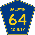
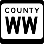
standard pattern), a black-on-white rectangle, or black text on a white rectangle (largely older signs). The majority of states have county highways, as they have unincorporated area
Unincorporated area
In law, an unincorporated area is a region of land that is not a part of any municipality.To "incorporate" in this context means to form a municipal corporation, a city, town, or village with its own government. An unincorporated community is usually not subject to or taxed by a municipal government...
s that are not part of any municipality
Municipality
A municipality is essentially an urban administrative division having corporate status and usually powers of self-government. It can also be used to mean the governing body of a municipality. A municipality is a general-purpose administrative subdivision, as opposed to a special-purpose district...
. Some states, like Virginia
Virginia
The Commonwealth of Virginia , is a U.S. state on the Atlantic Coast of the Southern United States. Virginia is nicknamed the "Old Dominion" and sometimes the "Mother of Presidents" after the eight U.S. presidents born there...
and North Carolina
North Carolina
North Carolina is a state located in the southeastern United States. The state borders South Carolina and Georgia to the south, Tennessee to the west and Virginia to the north. North Carolina contains 100 counties. Its capital is Raleigh, and its largest city is Charlotte...
, have no county highways in most of their counties; the state government maintains all roads in unincorporated areas. Others, like Connecticut
Connecticut
Connecticut is a state in the New England region of the northeastern United States. It is bordered by Rhode Island to the east, Massachusetts to the north, and the state of New York to the west and the south .Connecticut is named for the Connecticut River, the major U.S. river that approximately...
, have no county routes because there is no government at the county level. Alaska
Alaska
Alaska is the largest state in the United States by area. It is situated in the northwest extremity of the North American continent, with Canada to the east, the Arctic Ocean to the north, and the Pacific Ocean to the west and south, with Russia further west across the Bering Strait...
does not have counties; Louisiana
Louisiana
Louisiana is a state located in the southern region of the United States of America. Its capital is Baton Rouge and largest city is New Orleans. Louisiana is the only state in the U.S. with political subdivisions termed parishes, which are local governments equivalent to counties...
's county equivalents are parishes, and, accordingly, have parish routes.
In Minnesota
Minnesota
Minnesota is a U.S. state located in the Midwestern United States. The twelfth largest state of the U.S., it is the twenty-first most populous, with 5.3 million residents. Minnesota was carved out of the eastern half of the Minnesota Territory and admitted to the Union as the thirty-second state...
, some county roads are known as County state aid highways. These roads are constructed and maintained by counties, but they are eligible for funding from the County State Aid Highway Fund. Differences in signage between CSAH routes and other county roads depends on the county. Some counties, such as Stearns County, delineate between the two by using the "standard" blue pentagon shield for CSAH routes and Minnesota's normal white square shield for other county routes. Most county roads in Minnesota are designated with numbers, although a few non-CSAH's in Dodge County utilize letters instead. A few roads that cross county borders are also signed with an "inter-county" designation and a letter, but this system is not shown on most maps.
In the United States, county highways are denoted in various ways, differing by state. In states like Wisconsin
Wisconsin
Wisconsin is a U.S. state located in the north-central United States and is part of the Midwest. It is bordered by Minnesota to the west, Iowa to the southwest, Illinois to the south, Lake Michigan to the east, Michigan to the northeast, and Lake Superior to the north. Wisconsin's capital is...
, county highways are marked with letters—in Wisconsin with 1 to 3 letter combinations (i.e.: C, CC, or CCC). Wisconsin's county highways are frequently and clearly marked at most intersections. Because the county names are non-exclusive, the state has many county roads with similar or identical names. In states like Illinois
Illinois
Illinois is the fifth-most populous state of the United States of America, and is often noted for being a microcosm of the entire country. With Chicago in the northeast, small industrial cities and great agricultural productivity in central and northern Illinois, and natural resources like coal,...
, county highways are marked either with a number (usually 1 or 2 digits), a single letter followed by a 1 or 2 digit number (i.e.: V-34, A-29), or in Rock Island County, with letters like Wisconsin but on a blue pentagon shield. These highways are usually marked at the beginning of the highway and marked occasionally throughout the route, but are not majorly relied on as geographic directions the way more major highways (state or federal and interstate) are. In Iowa
Iowa
Iowa is a state located in the Midwestern United States, an area often referred to as the "American Heartland". It derives its name from the Ioway people, one of the many American Indian tribes that occupied the state at the time of European exploration. Iowa was a part of the French colony of New...
, county roads are marked with a single letter and a two digit number, such as B-26. In New Jersey
New Jersey
New Jersey is a state in the Northeastern and Middle Atlantic regions of the United States. , its population was 8,791,894. It is bordered on the north and east by the state of New York, on the southeast and south by the Atlantic Ocean, on the west by Pennsylvania and on the southwest by Delaware...
, there are two sets of county routes, the 500-series (500–599) which usually run through multiple counties, but are county-maintained, and the 600-series (600–799) which are usually contained within a single county. In New Jersey, county routes are usually signed just as well as state routes, including mile or half-mileposts, and appearances on freeway exit signage.
Canada
In CanadaCanada
Canada is a North American country consisting of ten provinces and three territories. Located in the northern part of the continent, it extends from the Atlantic Ocean in the east to the Pacific Ocean in the west, and northward into the Arctic Ocean...
, numbered county roads are only found in Ontario
Ontario
Ontario is a province of Canada, located in east-central Canada. It is Canada's most populous province and second largest in total area. It is home to the nation's most populous city, Toronto, and the nation's capital, Ottawa....
, where they are similar to American county highways. Ontario county or regional roads are marked with trapezoid-shaped signs, usually (but not necessarily) with a white, green, or blue background, and normally identifying the county or region responsible for the road's maintenance, sometimes with the jurisdiction's coat of arms
Coat of arms
A coat of arms is a unique heraldic design on a shield or escutcheon or on a surcoat or tabard used to cover and protect armour and to identify the wearer. Thus the term is often stated as "coat-armour", because it was anciently displayed on the front of a coat of cloth...
or corporate logo. The county road network has been present for many years, but has only been signed with the flowerpot logos since the 1970s and early 1980s (depending on the area). Previously, the roads simply had road names, such as "Essex Road 42" or "Kent County Road 14", and so on, but had no shields to designate them. Many Ontario county roads are built to provincial highway standards, as thousands of kilometres of highways were downloaded from the province to counties and regional municipalities
Regional municipality
A regional municipality is a type of Canadian municipal government similar to and at the same municipal government level as a county, although the specific structure and servicing responsibilities may vary from place to place...
in 1997 and 1998, and most of the downloaded highways were rolled into the county road systems. In some situations, these in turn were downloaded from the region/county to the local municipalities.
Not all jurisdictions in Ontario which maintain a county road system use the name "County Road" to designate them, however — depending on the type of census division
Census division
Census division is an official term in Canada and the United States. The census divisions of Canada are second-level census geographic unit, below provinces and territories, and above "census subdivisions" and "dissemination areas". In provinces where they exist, the census division may correspond...
which maintains them, they may also be designated as a Regional Road, Municipal Road, Regional/County Highway, District Road or City Road. In the unincorporated districts of Northern Ontario
Northern Ontario
Northern Ontario is a region of the Canadian province of Ontario which lies north of Lake Huron , the French River and Lake Nipissing. The region has a land area of 802,000 km2 and constitutes 87% of the land area of Ontario, although it contains only about 6% of the population...
, as there is no county level of government the province maintains a secondary highway system to serve the same function.
In addition to county roads, many townships also have concession road
Concession road
In Upper and Lower Canada, concession roads were laid out by the colonial government through undeveloped land to define lots to be developed; the name comes from a Lower Canadian French term for a row of lots. Concession roads are straight, and follow an approximately square grid, usually oriented...
s and township roads, such as Colchester South
Colchester South Township, Ontario
Colchester South Township was a former township located in Essex County, Ontario. Located on Lake Erie, it comprised the towns of Colchester and Harrow. It was amalgamated into the Town of Essex in 1999....
Road 3, and Concession 8. These do not have shields (only names on signs and maps), aside from one exception: former Highway 620. It was downloaded to the Peterborough
Peterborough County, Ontario
Peterborough County is located in Southern Ontario, Canada. It is projected to reach a population of 159,840 by 2031, according to the Ontario Ministry of Finance's Ontario Population Projections Update...
and Hastings County
Hastings County, Ontario
Hastings County is located in the province of Ontario, Canada. It is The Cheese Capital of Canada. Geographically, it is located on the border of Eastern Ontario and Central Ontario. The population was 125,915 in 2001 and grew to 130,474 in the 2006 Canada Census...
governments, and in one section, the highway was downloaded further to the township of Wollaston
Wollaston, Ontario
Wollaston is a township in Hastings County, Ontario, Canada. The township had a population of 730 in the Canada 2006 Census.-Demographics:Population trend:* Population in 2006: 730 * Population in 2001: 679...
, and is now signed as "Wollaston Township 620", with a municipal sign similar to an Ontario Tertiary Highway.
The city of Winnipeg
Winnipeg
Winnipeg is the capital and largest city of Manitoba, Canada, and is the primary municipality of the Winnipeg Capital Region, with more than half of Manitoba's population. It is located near the longitudinal centre of North America, at the confluence of the Red and Assiniboine Rivers .The name...
also maintains a system of numbered city roads.
See also
- County routes in CaliforniaCounty routes in CaliforniaIn the U.S. state of California, county routes are controlled and maintained by the respective counties in which they reside. However, they are generally patrolled by the state's California Highway Patrol....
- County routes in New JerseyCounty routes in New JerseyIn the U.S. state of New Jersey, county routes exist in all 21 counties. They are typically the fourth type of roadway classified below the Interstate Highway, the U.S. Route numbered highway and the state highway. The County Route system is defined by two types in New Jersey...
- County routes in New YorkCounty Routes in New YorkIn the U.S. state of New York, county routes exist in all 62 counties except those in the five boroughs of New York City. Most are maintained locally by county highway departments...
- County Trunk Highways (Wisconsin)County Trunk Highways (Wisconsin)County Trunk Highways are a system of highways maintained at the county level or below in the US state of Wisconsin. Every county maintains its own County Trunk Highway system....
- List of Michigan County-Designated Highways
- List of county roads in Ontario
- List of Winnipeg City Routes