

U.S. Route 83
Encyclopedia
U.S. Route 83 is one of the longest north–south U.S. Highways in the United States
, at 1885 miles (3,033.6 km). Only four other north–south routes are longer: U.S. Routes 1
, 41
, 59
and 87
. The highway's northern terminus is north of Westhope, North Dakota
, at the Canadian border, where it continues as Manitoba Highway 83
. The southern terminus is in Brownsville, Texas
, at the Veterans International Bridge on the Mexican border
, connecting with Mexican Federal Highway 180
.
Despite its length it has comparatively few concurrencies with any Interstate highways, and those segments are short. In no place has it been decommissioned
as a route.
, but in this brief 37 miles (59.5 km) stretch it encounters no fewer than three other federal highways. Approximately ten miles from the Texas line, US-83 intersects US-412 in the hamlet of Bryan's Corner. Continuing its journey northward, the highway crosses the Beaver River
, then intersects US-64 in Turpin
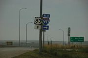
. US-83 North and US-64 East are co-signed for three northbound miles, where US-64 turns eastward. At this intersection, US-270 West joins the highway, and together with US-83 proceeds northbound for the final six miles (10 km) to the Kansas line.
, approximately four miles south of Liberal
, where it intersects US 54
. North of Liberal, US 83 begins a multiplex with US 160
, and the highways remain joined until reaching Sublette
, the seat of Haskell County
. US 83 and US 160 split north of Sublette, with US 160 heading west toward Ulysses
, and US 83 continuing north toward Garden City
.
At Garden City, US 50
and US 400
join US 83 for a brief concurrency on a bypass around the east and north sides of the city while U.S. 83 Business follows the former routing through downtown. All three routes cross K-156, also known as Kansas Avenue, in the northwest portion of the city. At the north end of the US 50-83 Business route, US 83 splits and heads north toward Scott City
, while US 50 and US 400 remain joined through the rest of the state. The highway passes through largely unpopulated areas of Finney County
and Scott County
before reaching a junction with K-96
in downtown Scott City.
In northern Scott County, K-4
has its origins at US 83, heading east toward Healy
, and US 83 traverses through rolling farmlands until reaching Oakley
, the seat of Logan County
. US 83 reaches US 40
less than a mile west of Interstate 70
, and the two highways jog west for a brief multiplex before US 83 splits and crosses I-70.
North of I-70, US 83 begins a concurrency with K-383, formerly US 383
. Passing to the east of Gem
in Thomas County
, US 83/K-383 takes a sharp northeasterly track through Rexford
and Selden
. After passing through Selden, K-383 splits from US 83 and continues northeast to US 36
, while US 83 meets the beginning of K-23.
US 83 returns to a northerly course at the Sheridan County
–Decatur County
line, and passes through Oberlin
at US 36. Oberlin is the last area of significant population the highway passes in Kansas; the next city is McCook, Nebraska
.
, where it meets U.S. Route 6
and U.S. Route 34
. It continues northward to North Platte
, where it intersects Interstate 80
and U.S. Route 30
. After leaving North Platte in a northeasterly direction, it turns north near Stapleton
and goes north through the Sand Hills
to Valentine
. For 5 miles (8 km) before Valentine, it runs concurrent with U.S. Route 20
. After passing through Valentine, it continues north to enter South Dakota.
 U.S. 83 enters South Dakota south of Olsonville on a segment of highway which passes through the Rosebud Indian Reservation
. After a brief overlap with U.S. Route 18
in Mission
, the route turns north and meets Interstate 90
at Murdo
. The two routes overlap as U.S. 83 goes east with I-90 until Vivian
, where U.S. 83 turns north. At Fort Pierre
, U.S. 83 meets U.S. Route 14
and South Dakota Highway 34
. The three highways overlap as they cross the Missouri River
and enter Pierre
. At Pierre, SD 34 separates and U.S. 83 turns northeast with U.S. 14. They separate near Blunt
and U.S. 83 turns northward. U.S. 83 briefly overlaps with U.S. Route 212
near Gettysburg
and with U.S. Route 12
through the Selby
area. U.S. 83 leaves South Dakota north of Herreid
.
The South Dakota section of U.S. 83, with the exception of concurrencies with U.S. 18, Interstate 90
, U.S. 14, U.S. 212, and U.S. 12, is defined at South Dakota Codified Laws § 31-4-180. http://legis.state.sd.us/statutes/DisplayStatute.aspx?Type=Statute&Statute=31-4-180
at the South Dakota state line, near the town of Hague
, and runs northward for approximately 68 miles (109.4 km) before reaching Interstate 94
. It follows I-94 west to Bismarck
, where it resumes a generally northward course. It traverses mostly agricultural land, with such towns as Washburn
and Underwood
, although some large strip-mining coal (lignite
) operations can be seen from the roadway in the vicinity of Falkirk.
North of Coleharbor
, the roadway and an adjacent railroad line cross a viaduct separating Lake Sakakawea
from Lake Audubon. Other than the lakes, the surroundings are mostly cropland and grazing land.
Route 83 passes directly through Minot
, where it is known as Broadway, although a bypass to the west of town is an alternative route. From Minot, the northbound route passes Minot Air Force Base
where it becomes a two-lane highway again, shares a roadway with eastbound North Dakota Highway 5
, and diverges from N.D. 5 to head north to the Canadian
border.
United States
The United States of America is a federal constitutional republic comprising fifty states and a federal district...
, at 1885 miles (3,033.6 km). Only four other north–south routes are longer: U.S. Routes 1
U.S. Route 1
U.S. Route 1 is a major north–south U.S. Highway that serves the East Coast of the United States. It runs 2,377 miles from Fort Kent, Maine at the Canadian border south to Key West, Florida. U.S. 1 generally parallels Interstate 95, though it is significantly farther west between...
, 41
U.S. Route 41
U.S. Route 41 is a north–south United States Highway that runs from Miami, Florida to the Upper Peninsula of Michigan. Until 1949, the part in southern Florida, from Naples to Miami, was U.S...
, 59
U.S. Route 59
U.S. Route 59 is a north–south United States highway . A latecomer to the U.S. numbered route system, U.S. 59 is now a border-to-border route, Part of NAFTA Corridor Highway System. It parallels U.S. Route 75 for nearly its entire route, never much more than away, until it veers southwest...
and 87
U.S. Route 87
U.S. Highway 87 is a north–south United States highway that runs for 1,998 miles from northern Montana to southern Texas. Most of the portion from Billings, Montana, to Raton, New Mexico, is co-signed along Interstates 90 and 25...
. The highway's northern terminus is north of Westhope, North Dakota
Westhope, North Dakota
As of the census of 2000, there were 533 people, 228 households, and 134 families residing in the city. The population density was 1,663.5 people per square mile . There were 268 housing units at an average density of 836.5 per square mile...
, at the Canadian border, where it continues as Manitoba Highway 83
Manitoba Highway 83
Provincial Trunk Highway 83 is a major north-south highway that runs in the far western region of the Canadian province of Manitoba. It travels from the North Dakota border south of Melita, north through Virden, Birtle, Russell, and Roblin to its northern terminus with PTH 10 just east of Swan River...
. The southern terminus is in Brownsville, Texas
Brownsville, Texas
Brownsville is a city in the southernmost tip of the state of Texas, in the United States. It is located on the northern bank of the Rio Grande, directly north and across the border from Matamoros, Tamaulipas, Mexico. Brownsville is the 16th largest city in the state of Texas with a population of...
, at the Veterans International Bridge on the Mexican border
United States–Mexico border
The United States–Mexico border is the international border between the United States and Mexico. It runs from Imperial Beach, California, and Tijuana, Baja California, in the west to Matamoros, Tamaulipas, and Brownsville, Texas, in the east, and traverses a variety of terrains, ranging from major...
, connecting with Mexican Federal Highway 180
Mexican Federal Highway 180
Mexican Federal Highway 180 is a Mexican Federal Highway that follows Mexico's Gulf and Caribbean Coast from the Mexico-U.S. border at Brownsville, Texas, into Matamoros, Tamaulipas, to the resort city of Cancún, Quintana Roo, in the Yucatán Peninsula....
.
Despite its length it has comparatively few concurrencies with any Interstate highways, and those segments are short. In no place has it been decommissioned
Decommissioned highway
A decommissioned highway is a highway that has been removed from service, shut down or has had its authorization as a federal or state highway removed. Decommissioning can include the complete or partial demolition or abandonment of an old highway structure because the old roadway has lost its...
as a route.
Oklahoma
US-83 traverses the Oklahoma panhandle along the western border of Beaver CountyBeaver County, Oklahoma
Beaver County is a county located in the U.S. state of Oklahoma. As of the 2010 census, the population was 5,636. The county seat is Beaver....
, but in this brief 37 miles (59.5 km) stretch it encounters no fewer than three other federal highways. Approximately ten miles from the Texas line, US-83 intersects US-412 in the hamlet of Bryan's Corner. Continuing its journey northward, the highway crosses the Beaver River
Beaver River (Oklahoma)
The Beaver River is the historic name for an intermittent river in Oklahoma that drains most of the Oklahoma Panhandle. It is also known as the North Canadian River. Both names are in common use. By one convention the headwaters of the Beaver River are at the convergence of the Corrumpa, Rafael,...
, then intersects US-64 in Turpin
Turpin, Oklahoma
Turpin is a small unincorporated community in Beaver County, Oklahoma, United States. The post office was established April 8, 1925. The Turpin Grain Elevator is on the National Register of Historic Places....
. US-83 North and US-64 East are co-signed for three northbound miles, where US-64 turns eastward. At this intersection, US-270 West joins the highway, and together with US-83 proceeds northbound for the final six miles (10 km) to the Kansas line.
Kansas
US 83 enters the Sunflower State in Seward CountySeward County, Kansas
Seward County is a county of the U.S. state of Kansas. As of the 2010 census, the county population was 22,952. The largest city and county seat is Liberal...
, approximately four miles south of Liberal
Liberal, Kansas
Liberal is the county seat of Seward County, Kansas, United States. As of the 2010 census, the city population was 20,525.- History :S.S. Rogers built the first house in what would become Liberal in 1872. Rogers became famous in the region for giving water to weary travelers...
, where it intersects US 54
U.S. Route 54
U.S. Route 54 is an east–west United States highway that runs northeast-southwest for 1,197 miles from western Illinois to El Paso, Texas. It enters and leaves Texas twice...
. North of Liberal, US 83 begins a multiplex with US 160
U.S. Route 160
U.S. Route 160 is a 1,465 mile long east–west United States highway in the Midwestern United States. The western terminus of the route is at U.S. Route 89 five miles west of Tuba City, Arizona. The eastern terminus is at U.S...
, and the highways remain joined until reaching Sublette
Sublette, Kansas
Sublette is a city in and the county seat of Haskell County, Kansas, United States. As of the 2010 census, the city population was 1,453.-History:...
, the seat of Haskell County
Haskell County, Kansas
Haskell County is a county located in Southwest Kansas, in the Central United States. As of the 2010 census, the county population was 4,256...
. US 83 and US 160 split north of Sublette, with US 160 heading west toward Ulysses
Ulysses, Kansas
Ulysses is a city in and the county seat of Grant County, Kansas, United States. As of the 2010 census, the city population was 6,161.-Geography:Ulysses is located at...
, and US 83 continuing north toward Garden City
Garden City, Kansas
Garden City is a city in and the county seat of Finney County, Kansas, United States. As of the 2010 census, the city population was 26,658. The city is home to Garden City Community College and the Lee Richardson Zoo, the largest zoological park in western Kansas.-History:In February 1878, James...
.
At Garden City, US 50
U.S. Route 50
U.S. Route 50 is a major east–west route of the U.S. Highway system, stretching just over from Ocean City, Maryland on the Atlantic Ocean to West Sacramento, California. Until 1972, when it was replaced by Interstate Highways west of the Sacramento area, it extended to San Francisco, near...
and US 400
U.S. Route 400
U.S. Route 400 is a mostly east–west U.S. Highway, commissioned in 1994. Its route number is a "violation" of the usual AASHTO numbering scheme, as there is no US 0 or US 100....
join US 83 for a brief concurrency on a bypass around the east and north sides of the city while U.S. 83 Business follows the former routing through downtown. All three routes cross K-156, also known as Kansas Avenue, in the northwest portion of the city. At the north end of the US 50-83 Business route, US 83 splits and heads north toward Scott City
Scott City, Kansas
Scott City is a city in and the county seat of Scott County, Kansas, United States. As of the 2010 census, the city population was 3,816.-Geography:Scott City is located at...
, while US 50 and US 400 remain joined through the rest of the state. The highway passes through largely unpopulated areas of Finney County
Finney County, Kansas
Finney County is a county located in Southwest Kansas, in the Central United States. As of the 2010 census, the county population was 36,776. Its county seat and most populous city is Garden City...
and Scott County
Scott County, Kansas
Scott County is a county located in the U.S. state of Kansas. As of the 2010 census, the county population was 4,936...
before reaching a junction with K-96
K-96 (Kansas highway)
K-96 is a state highway in central and southern Kansas. Its western terminus is at the Colorado state line east of Towner, Colorado, where it continues as Colorado State Highway 96; its eastern terminus since 1999 is at U.S. Route 54/U.S. Route 400 east of Wichita.The eastern terminus was once at...
in downtown Scott City.
In northern Scott County, K-4
K-4 (Kansas highway)
K-4 is the longest designated state highway in Kansas traversing from north of Scott City at US-83 to US-59 near Nortonville in northeast Kansas. A segment of the highway in McPherson County overlaps Interstate 135, and a section in Topeka runs concurrent with Interstate 70.-Western Kansas:K-4...
has its origins at US 83, heading east toward Healy
Healy, Kansas
Healy is an unincorporated rural area in Lane County, Kansas, United States. It lies in Cheyenne Township on K-4 16 miles east of the highway's western end at U.S. Route 83.-External links:* * , local school district*...
, and US 83 traverses through rolling farmlands until reaching Oakley
Oakley, Kansas
Oakley is a city in Gove, Logan, and Thomas counties in the U.S. state of Kansas. As of the 2010 census, the city population was 2,045. It is the county seat of Logan County.-Geography:...
, the seat of Logan County
Logan County, Kansas
Logan County is a county located in the U.S. state of Kansas. As of the 2010 census, the county population was 2,756...
. US 83 reaches US 40
U.S. Route 40
U.S. Route 40 is an east–west United States highway. As with most routes whose numbers end in a zero, U.S. 40 once traversed the entire United States. It is one of the original 1920s U.S. Highways, and its first termini were San Francisco, California, and Atlantic City, New Jersey...
less than a mile west of Interstate 70
Interstate 70 in Kansas
In the U.S. state of Kansas, Interstate 70 contains the first segment to start being paved and to be completed in the Interstate Highway System. It extends from the Western border to the Eastern border covering and passing through several of the state's principal cities in the process.-Route...
, and the two highways jog west for a brief multiplex before US 83 splits and crosses I-70.
North of I-70, US 83 begins a concurrency with K-383, formerly US 383
U.S. Route 383
U.S. Route 383 was a north–south United States highway. US 383 was created in 1942, and deleted in 1982. After deletion, a portion of the highway became K-383.-Kansas:...
. Passing to the east of Gem
Gem, Kansas
Gem is a city in Thomas County, Kansas, United States. As of the 2010 census, the city population was 88.-Geography:Gem is located at . According to the United States Census Bureau, the city has a total area of , all of it land....
in Thomas County
Thomas County, Kansas
Thomas County is a county located in the U.S. state of Kansas. As of the 2010 census, the county population was 7,900...
, US 83/K-383 takes a sharp northeasterly track through Rexford
Rexford, Kansas
Rexford is a city in Thomas County, Kansas, United States. As of the 2010 census, the city population was 232.-Geography:Rexford is located at . According to the United States Census Bureau, the city has a total area of , all of it land.-Demographics:As of the census of 2000, there were 157...
and Selden
Selden, Kansas
Selden is a city in Sheridan County, Kansas, United States. As of the 2010 census, the city population was 219.-Geography:Selden is located at . According to the United States Census Bureau, the city has a total area of , all of it land.-Demographics:As of the census of 2000, there were 201...
. After passing through Selden, K-383 splits from US 83 and continues northeast to US 36
U.S. Route 36
U.S. Route 36 is an east–west United States highway that runs for from Rocky Mountain National Park, Colorado to Uhrichsville, Ohio. The highway's western terminus is at Deer Ridge Junction, an intersection in Rocky Mountain National Park, Colorado, where it meets U.S. Route 34. Its eastern...
, while US 83 meets the beginning of K-23.
US 83 returns to a northerly course at the Sheridan County
Sheridan County, Kansas
Sheridan County is a county located in the U.S. state of Kansas. As of the 2010 census, the county population was 2,556. Its county seat is Hoxie. The county was named in honor of Phillip H...
–Decatur County
Decatur County, Kansas
Decatur County is a county located in Northwest Kansas, in the Central United States. As of the 2010 census, the county population was 2,961. Its county seat and most populous city is Oberlin. The county is named in honor of Commodore Stephen Decatur, Jr.-History:The county was established...
line, and passes through Oberlin
Oberlin, Kansas
Oberlin is a city in and the county seat of Decatur County, Kansas, United States. As of the 2010 census, the city population was 1,788.-History:...
at US 36. Oberlin is the last area of significant population the highway passes in Kansas; the next city is McCook, Nebraska
McCook, Nebraska
McCook is a city in Red Willow County, Nebraska, United States. The population was 7,994 at the 2000 census. It is the county seat of Red Willow County...
.
Nebraska
U.S. 83 enters Nebraska south of McCookMcCook, Nebraska
McCook is a city in Red Willow County, Nebraska, United States. The population was 7,994 at the 2000 census. It is the county seat of Red Willow County...
, where it meets U.S. Route 6
U.S. Route 6
U.S. Route 6 , also called the Grand Army of the Republic Highway, a name that honors an American Civil War veterans association, is a main route of the U.S. Highway system, running east-northeast from Bishop, California to Provincetown, Massachusetts. Until 1964, it continued south from Bishop to...
and U.S. Route 34
U.S. Route 34
U.S. Route 34 is an east–west United States highway that runs for 1,122 miles from north-central Colorado to the western suburbs of Chicago. Through Rocky Mountain National Park it is known as the Trail Ridge Road where it reaches 12,183 ft , making it the highest paved through highway in...
. It continues northward to North Platte
North Platte, Nebraska
North Platte is a city in and the county seat of Lincoln County, Nebraska, United States. It is located in the southwestern part of the state, along Interstate 80, at the confluence of the North and South Platte Rivers forming the Platte River...
, where it intersects Interstate 80
Interstate 80
Interstate 80 is the second-longest Interstate Highway in the United States, following Interstate 90. It is a transcontinental artery running from downtown San Francisco, California to Teaneck, New Jersey in the New York City Metropolitan Area...
and U.S. Route 30
U.S. Route 30
U.S. Route 30 is an east–west main route of the system of United States Numbered Highways, with the highway traveling across the northern tier of the country. It is the third longest U.S. route, after U.S. Route 20 and U.S. Route 6. The western end of the highway is at Astoria, Oregon; the...
. After leaving North Platte in a northeasterly direction, it turns north near Stapleton
Stapleton, Nebraska
Stapleton is a village in and the county seat of Logan County, Nebraska, United States. The population was 301 at the 2000 census.Stapleton is part of the North Platte, Nebraska Micropolitan Statistical Area.-Geography:...
and goes north through the Sand Hills
Sand Hills (Nebraska)
The Sand Hills, often written Sandhills, is a region of mixed-grass prairie on grass-stabilized sand dunes in north-central Nebraska, covering just over one quarter of the state...
to Valentine
Valentine, Nebraska
-Demographics:As of the census of 2000, there were 2,820 people, 1,209 households, and 733 families residing in the city. The population density was 1,401.1 people per square mile . There were 1,373 housing units at an average density of 682.2 per square mile...
. For 5 miles (8 km) before Valentine, it runs concurrent with U.S. Route 20
U.S. Route 20
U.S. Route 20 is an east–west United States highway. As the "0" in its route number implies, US 20 is a coast-to-coast route. Spanning , it is the longest road in the United States, and the route sparsely parallels Interstate 90...
. After passing through Valentine, it continues north to enter South Dakota.
South Dakota
Rosebud Indian Reservation
The Rosebud Indian Reservation is an Indian reservation in South Dakota, United States. It is the home of the federally recognized Sicangu Oyate, also known as Sicangu Lakota, the Upper Brulé Sioux Nation, and the Rosebud Sioux Tribe , a branch of the Lakota people...
. After a brief overlap with U.S. Route 18
U.S. Route 18
U.S. Route 18 is an east–west U.S. highway in the Midwestern United States. The western terminus is in Orin, Wyoming at an interchange with Interstate 25. Its eastern terminus of US 18 is in downtown Milwaukee, Wisconsin. However, US 18 runs concurrent with other U.S...
in Mission
Mission, South Dakota
Mission is a city in Todd County, South Dakota, United States, and the Rosebud Indian Reservation. The population was 1,182 at the 2010 census....
, the route turns north and meets Interstate 90
Interstate 90
Interstate 90 is the longest Interstate Highway in the United States at . It is the northernmost coast-to-coast interstate, and parallels US 20 for the most part. Its western terminus is in Seattle, at Edgar Martinez Drive S. near Safeco Field and CenturyLink Field, and its eastern terminus is in...
at Murdo
Murdo, South Dakota
Murdo is a city in Jones County, South Dakota, United States. The population was 488 at the 2010 census. It is the county seat of Jones County. Murdo is named for Murdo MacKenzie, a Texas cattleman, and was the hometown of current Republican U.S...
. The two routes overlap as U.S. 83 goes east with I-90 until Vivian
Vivian, South Dakota
Vivian is a census-designated place in Lyman County, South Dakota. The population was 119 at the 2010 census.-Geography:Vivian is located at ....
, where U.S. 83 turns north. At Fort Pierre
Fort Pierre, South Dakota
Fort Pierre is a city in Stanley County, South Dakota, United States. It is part of the Pierre, South Dakota Micropolitan Statistical Area. The population was 2,078 at the 2010 census. It is the county seat of Stanley County. Lily Park, in Fort Pierre, is situated at the mouth of the Bad River. The...
, U.S. 83 meets U.S. Route 14
U.S. Route 14
U.S. Route 14 , an east–west route, is one of the original United States highways of 1926. It currently has a length of 1,398 miles , but it had a peak length of 1,429 miles . For much of its length, it runs roughly parallel to Interstate 90.As of 2004, the highway's eastern terminus is in...
and South Dakota Highway 34
South Dakota Highway 34
South Dakota Highway 34 is a state route that runs across the entire state of South Dakota, parallel to Interstate 90. It begins at the Wyoming border west of Belle Fourche, as a continuation of Wyoming Highway 24. The eastern terminus is at the Minnesota border east of Egan, or southwest of...
. The three highways overlap as they cross the Missouri River
Missouri River
The Missouri River flows through the central United States, and is a tributary of the Mississippi River. It is the longest river in North America and drains the third largest area, though only the thirteenth largest by discharge. The Missouri's watershed encompasses most of the American Great...
and enter Pierre
Pierre, South Dakota
Pierre is the capital of the U.S. state of South Dakota and the county seat of Hughes County. The population was 13,646 at the 2010 census, making it the second least populous state capital after Montpelier, Vermont...
. At Pierre, SD 34 separates and U.S. 83 turns northeast with U.S. 14. They separate near Blunt
Blunt, South Dakota
Blunt is a city in Hughes County, South Dakota, United States. It is part of the Pierre, South Dakota Micropolitan Statistical Area. The population was 354 at the 2010 census.-Geography:...
and U.S. 83 turns northward. U.S. 83 briefly overlaps with U.S. Route 212
U.S. Route 212
U.S. Route 212 is a spur of U.S. Route 12. Though it currently never intersects U.S. 12, it once had an eastern terminus at U.S. 12 in St. Paul, Minnesota. It runs for 949 miles from Minnesota Highway 62 at Edina, Minnesota to Yellowstone National Park.U.S. 212 passes through the states of...
near Gettysburg
Gettysburg, South Dakota
Gettysburg is a city in Potter County, South Dakota, United States, along the 45th parallel. The population was 1,162 at the 2010 census. It is the county seat of Potter County. Gettysburg area historical tornado activity is 42 percent less than the overall U.S...
and with U.S. Route 12
U.S. Route 12
U.S. Route 12 or US 12 is an east–west United States highway, running from Grays Harbor on the Pacific Ocean, in the state of Washington, to downtown Detroit, for almost . As a thoroughfare, it has mostly been supplanted by I-90 and I-94, but remains an important road for local travel.The...
through the Selby
Selby, South Dakota
Selby is a city in Walworth County, South Dakota, United States. The population was 642 at the 2010 census. It is the county seat of Walworth County.-Geography:Selby is located at ....
area. U.S. 83 leaves South Dakota north of Herreid
Herreid, South Dakota
Herreid is a city in Campbell County, South Dakota, United States. The population was 438 at the 2010 census. The city is named after Charles N...
.
The South Dakota section of U.S. 83, with the exception of concurrencies with U.S. 18, Interstate 90
Interstate 90
Interstate 90 is the longest Interstate Highway in the United States at . It is the northernmost coast-to-coast interstate, and parallels US 20 for the most part. Its western terminus is in Seattle, at Edgar Martinez Drive S. near Safeco Field and CenturyLink Field, and its eastern terminus is in...
, U.S. 14, U.S. 212, and U.S. 12, is defined at South Dakota Codified Laws § 31-4-180. http://legis.state.sd.us/statutes/DisplayStatute.aspx?Type=Statute&Statute=31-4-180
North Dakota
U.S. 83 enters North DakotaNorth Dakota
North Dakota is a state located in the Midwestern region of the United States of America, along the Canadian border. The state is bordered by Canada to the north, Minnesota to the east, South Dakota to the south and Montana to the west. North Dakota is the 19th-largest state by area in the U.S....
at the South Dakota state line, near the town of Hague
Hague, North Dakota
As of the census of 2000, there were 91 people, 43 households, and 28 families residing in the city. The population density was 330.4 people per square mile . There were 53 housing units at an average density of 192.4 per square mile . The racial makeup of the city was 96.70% White, 1.10% African...
, and runs northward for approximately 68 miles (109.4 km) before reaching Interstate 94
Interstate 94
Interstate 94 is the northernmost east–west Interstate Highway, connecting the Great Lakes and Intermountain regions of the United States. I-94's western terminus is in Billings, Montana at a junction with Interstate 90; its eastern terminus is the U.S...
. It follows I-94 west to Bismarck
Bismarck, North Dakota
Bismarck is the capital of the U.S. state of North Dakota and the county seat of Burleigh County. It is the second most populous city in North Dakota after Fargo. The city's population was 61,272 at the 2010 census, while its metropolitan population was 108,779...
, where it resumes a generally northward course. It traverses mostly agricultural land, with such towns as Washburn
Washburn, North Dakota
Washburn is a city in McLean County, North Dakota in the United States. It is the county seat of McLean County. The population was 1,246 at the 2010 census...
and Underwood
Underwood, North Dakota
As of the census of 2000, there were 812 people, 323 households, and 229 families residing in the city. The population density was 910.8 people per square mile . There were 381 housing units at an average density of 427.3 per square mile . The racial makeup of the city was 96.80% White, 1.11%...
, although some large strip-mining coal (lignite
Lignite
Lignite, often referred to as brown coal, or Rosebud coal by Northern Pacific Railroad,is a soft brown fuel with characteristics that put it somewhere between coal and peat...
) operations can be seen from the roadway in the vicinity of Falkirk.
North of Coleharbor
Coleharbor, North Dakota
As of the census of 2000, there were 106 people, 42 households, and 30 families residing in the city. The population density was 581.2 people per square mile . There were 56 housing units at an average density of 307.0 per square mile...
, the roadway and an adjacent railroad line cross a viaduct separating Lake Sakakawea
Lake Sakakawea
Lake Sakakawea is a reservoir in the Missouri River basin in central North Dakota. Named for the Shoshone-Hidatsa woman Sakakawea, it is the third largest man-made lake in the United States, after Lake Mead and Lake Powell. The lake lies in parts of six counties in western North Dakota: Dunn,...
from Lake Audubon. Other than the lakes, the surroundings are mostly cropland and grazing land.
Route 83 passes directly through Minot
Minot, North Dakota
Minot is a city located in north central North Dakota in the United States. It is most widely known for the Air Force base located approximately 15 miles north of the city. With a population of 40,888 at the 2010 census, Minot is the fourth largest city in the state...
, where it is known as Broadway, although a bypass to the west of town is an alternative route. From Minot, the northbound route passes Minot Air Force Base
Minot Air Force Base
Minot Air Force Base is a U.S. Air Force installation in Ward County, North Dakota, north of the city of Minot. In the 2010 census, the base was counted as a CDP with a total population of 5,521....
where it becomes a two-lane highway again, shares a roadway with eastbound North Dakota Highway 5
North Dakota Highway 5
North Dakota 5 is a mostly two-lane and long east–west highway the touches the northern border of the state and is never farther than about 17 miles south of the Canadian border. The eastern terminus is located about four miles east of Joliette at the Red River where the highway continues...
, and diverges from N.D. 5 to head north to the Canadian
Canada
Canada is a North American country consisting of ten provinces and three territories. Located in the northern part of the continent, it extends from the Atlantic Ocean in the east to the Pacific Ocean in the west, and northward into the Arctic Ocean...
border.
Major intersections
- U.S. Highway 2/U.S. Highway 52 in Minot, North Dakota
- Interstate 94Interstate 94Interstate 94 is the northernmost east–west Interstate Highway, connecting the Great Lakes and Intermountain regions of the United States. I-94's western terminus is in Billings, Montana at a junction with Interstate 90; its eastern terminus is the U.S...
concurrent between BismarckBismarck, North DakotaBismarck is the capital of the U.S. state of North Dakota and the county seat of Burleigh County. It is the second most populous city in North Dakota after Fargo. The city's population was 61,272 at the 2010 census, while its metropolitan population was 108,779...
and SterlingSterling, North DakotaSterling is an unincorporated community in Burleigh County, North Dakota, United States at the intersection of Interstate 94 and U.S. Route 83. It is part of the "Bismarck, ND Metropolitan Statistical Area" or "Bismarck-Mandan". Sterling's US Postal Code is 58572.Sterling was not a...
, North DakotaNorth DakotaNorth Dakota is a state located in the Midwestern region of the United States of America, along the Canadian border. The state is bordered by Canada to the north, Minnesota to the east, South Dakota to the south and Montana to the west. North Dakota is the 19th-largest state by area in the U.S.... - U.S. Highway 12 Near Selby, South Dakota
- U.S. Highway 14 west of Blunt, South Dakota
- Interstate 90Interstate 90Interstate 90 is the longest Interstate Highway in the United States at . It is the northernmost coast-to-coast interstate, and parallels US 20 for the most part. Its western terminus is in Seattle, at Edgar Martinez Drive S. near Safeco Field and CenturyLink Field, and its eastern terminus is in...
concurrent between VivianVivian, South DakotaVivian is a census-designated place in Lyman County, South Dakota. The population was 119 at the 2010 census.-Geography:Vivian is located at ....
and MurdoMurdo, South DakotaMurdo is a city in Jones County, South Dakota, United States. The population was 488 at the 2010 census. It is the county seat of Jones County. Murdo is named for Murdo MacKenzie, a Texas cattleman, and was the hometown of current Republican U.S...
, South DakotaSouth DakotaSouth Dakota is a state located in the Midwestern region of the United States. It is named after the Lakota and Dakota Sioux American Indian tribes. Once a part of Dakota Territory, South Dakota became a state on November 2, 1889. The state has an area of and an estimated population of just over... - U.S. Highway 18 west of Misson, South Dakota
- U.S. Highway 20 in Valentine, Nebraska
- U.S. Highway 30 in North Platte, Nebraska
- Interstate 80Interstate 80Interstate 80 is the second-longest Interstate Highway in the United States, following Interstate 90. It is a transcontinental artery running from downtown San Francisco, California to Teaneck, New Jersey in the New York City Metropolitan Area...
in North Platte, NebraskaNorth Platte, NebraskaNorth Platte is a city in and the county seat of Lincoln County, Nebraska, United States. It is located in the southwestern part of the state, along Interstate 80, at the confluence of the North and South Platte Rivers forming the Platte River... - U.S. Highway 6 and U.S. Highway 34 in McCook, Nebraska
- U.S. Highway 36 in Oberlin, Kansas
- U.S. Highway 24 east of Colby, Kansas
- Interstate 70Interstate 70Interstate 70 is an Interstate Highway in the United States that runs from Interstate 15 near Cove Fort, Utah, to a Park and Ride near Baltimore, Maryland. It was the first Interstate Highway project in the United States. I-70 approximately traces the path of U.S. Route 40 east of the Rocky...
in Oakley, KansasOakley, KansasOakley is a city in Gove, Logan, and Thomas counties in the U.S. state of Kansas. As of the 2010 census, the city population was 2,045. It is the county seat of Logan County.-Geography:... - U.S. Highway 40 in Oakley, Kansas
- U.S. Highway 50 and U.S. Highway 400 in Garden City, Kansas
- U.S. Highway 56 in Sublette, Kansas
- U.S. Highway 54 in Liberal, Kansas
- U.S. Highway 64 and U.S. Highway 270 south of Liberal, Kansas (in Oklahoma)
- U.S. Highway 60 north of Canadian, TexasCanadian, TexasCanadian is the county seat of Hemphill County, Texas, United States. The population was 2,233 at the 2000 census. It is named for the Canadian River, a tributary of the nearby Arkansas River. Canadian is sometimes called "the oasis of the Texas Panhandle."-History:The trails along the river are...
- Interstate 40Interstate 40Interstate 40 is the third-longest major east–west Interstate Highway in the United States, after I-90 and I-80. Its western end is at Interstate 15 in Barstow, California; its eastern end is at a concurrency of U.S. Route 117 and North Carolina Highway 132 in Wilmington, North Carolina...
in Shamrock, TexasShamrock, Texas-Demographics:As of the census of 2000, there were 2,029 people, 852 households, and 550 families residing in the city. The population density was 979.7 people per square mile . There were 1,072 housing units at an average density of 517.6 per square mile... - U.S. Highway 70 and U.S. Highway 62 in Paducah, TexasPaducah, TexasPaducah is a town in Cottle County, Texas, United States. The population was 1,498 at the 2000 census. It is the county seat of Cottle County...
- U.S. Highway 82 in Guthrie, TexasGuthrie, TexasGuthrie is a Census Designated Place in King County in the U.S. state of Texas. It lies at the junction of U.S. Routes 82 and 83 ninety-six miles east of Lubbock, and serves as the principal headquarters of the Four Sixes Ranch...
- Interstate 20Interstate 20Interstate 20 is a major east–west Interstate Highway in the Southern United States. I‑20 runs 1,535 miles from near Kent, Texas, at Interstate 10 to Florence, South Carolina, at Interstate 95...
and U.S. Highway 84 in Abilene, TexasAbilene, TexasAbilene is a city in Taylor and Jones counties in west central Texas. The population was 117,063 at the 2010 census. It is the principal city of the Abilene Metropolitan Statistical Area, which had a 2006 estimated population of 158,063. It is the county seat of Taylor County... - U.S. Highway 67 in Ballinger, TexasBallinger, TexasBallinger is a small town in the heart of Texas. Ballinger holds itself as county seat of Runnels County, Texas, United States. The population was 4,243 at the 2000 census...
- Interstate 10Interstate 10Interstate 10 is the fourth-longest Interstate Highway in the United States, after I-90, I-80, and I-40. It is the southernmost east–west, coast-to-coast Interstate Highway, although I-4 and I-8 are further south. It stretches from the Pacific Ocean at State Route 1 in Santa Monica,...
in Junction, TexasJunction, TexasJunction is a city in and the county seat of Kimble County, Texas, United States. The population was 2,618 at the 2000 census.-Geography:... - U.S. Route 90U.S. Route 90U.S. Route 90 is an east–west United States highway. Despite the "0" in its route number, U.S. 90 never was a full coast-to-coast route; it has always ended at Van Horn, Texas. A short-lived northward extension to U.S...
in Uvalde, TexasUvalde, TexasUvalde is a city in and the county seat of Uvalde County, Texas, United States. The population was 14,929 at the 2000 census.Uvalde was founded by Reading Wood Black in 1853 as the town of Encina. In 1856, when the county was organized, the town was renamed Uvalde for Spanish governor Juan de... - U.S. Highway 57 south of Uvalde
- Interstate 35Interstate 35Interstate 35 is a north–south Interstate Highway in the central United States. I-35 stretches from Laredo, Texas, on the U.S.-Mexico border to Duluth, Minnesota, at Minnesota Highway 61 and 26th Avenue East. Many interstates used to have splits or spurs indicated with suffixed letters , but I-35...
and U.S. Highway 59 in Laredo, TexasLaredo, TexasLaredo is the county seat of Webb County, Texas, United States, located on the north bank of the Rio Grande in South Texas, across from Nuevo Laredo, Tamaulipas, Mexico. According to the 2010 census, the city population was 236,091 making it the 3rd largest on the United States-Mexican border,... - U.S. Highway 281 in Pharr, TexasPharr, TexasPharr is a city in Hidalgo County, Texas, United States. As of the 2010 census, the city population was 70,400. Pharr is connected by bridge to the Mexican city of Reynosa, Tamaulipas...
- U.S. Highway 77 in Harlingen, TexasHarlingen, TexasHarlingen is a city in Cameron County in the heart of the Rio Grande Valley of south Texas, United States, about from the coast of the Gulf of Mexico. The city covers more than , and is the second largest city in Cameron County and the sixth largest in the Rio Grande Valley...