
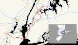
Interstate 278
Encyclopedia
Interstate 278 is an auxiliary Interstate Highway in New Jersey
and New York
, United States
. The road runs 35.62 miles (57.32 km) from U.S. Route 1/9 (US 1/9) in Linden, New Jersey
to the Bruckner Interchange
in the New York City
borough of the Bronx
. It serves as a partial beltway through the eastern section of New York City and passes through all five of the city's borough
s (though through Manhattan
only because the Robert F. Kennedy Bridge crosses Wards Island, which is part of Manhattan). The majority of I-278 is in New York City. I-278 follows several freeways, including the Union Freeway in Union County, New Jersey
, the Staten Island Expressway (SIE) across Staten Island
, the Gowanus Expressway in southern Brooklyn, the Brooklyn-Queens Expressway (BQE) across northern Brooklyn and Queens, a small part of the Grand Central Parkway in Queens, and a part of the Bruckner Expressway
in the Bronx. I-278 also crosses multiple bridges, including the Goethals Bridge
between New Jersey and Staten Island, the Verrazano Narrows Bridge between Staten Island and Brooklyn, the Kosciuszko Bridge
between Brooklyn and Queens, and the Robert F. Kennedy Bridge.
Despite its number, I-278 does not connect to I-78
; however, there were once plans to extend I-278 west to I-78 east of the Route 24
interchange in Springfield, New Jersey
. This was cancelled due to opposition from the communities along the route. The segment that does exist in New Jersey was opened in 1969. There were also plans to extend I-78 east across Manhattan and into Brooklyn via the Williamsburg Bridge
; this would have been a second location where the two highways would have interchanged, but these plans were also thwarted. In New York, the various parts of I-278 were planned by Robert Moses
, an urban planner in New York City. Some of these completed segments predated the Interstate Highway System and are thus not up to standards. Over the years, portions of I-278 have required upgrading. In addition, they tore through many New York City neighborhoods, causing controversy. All of I-278 through New York City was completed by the 1960s. I-87
was once planned to follow the segment of I-278 between the Williamsburg Bridge
and the Major Deegan Expressway
, but this ultimately became a part of I-278. In addition, the Bruckner Expressway portion of I-278 had been designated with different route numbers. At first, it was to be I-895
between I-87 and the Sheridan Expressway and I-678
past there. Later, I-278 was planned to follow the Bruckner Expressway and the Sheridan Expressway to I-95 (with no route number for the Bruckner Expressway past there) before the current numbering took place by 1970, with I-895 designated onto the Sheridan Expressway.
|NJ
|| 2.00|| 3.22
|-
|NY
|| 33.62 || 54.11
|-
|Total || 35.62 || 57.32
|}
The New Jersey segment of I-278 begins in Linden
, Union County
at the junction with US 1/9
, where it merges into the southbound direction of that road. The freeway heads east and carries two lanes in each direction, with the eastbound direction widening to three lanes. I-278 runs between urban residential areas to the north and the Bayway Refinery
to the south as it continues into Elizabeth
. In this area, the road meets Route 439
and the New Jersey Turnpike
(I-95
) at the only intermediate interchange that I-278 has in New Jersey. This short length is sometimes called the Union Freeway. After the New Jersey Turnpike, I-278 turns southeast and crosses the Arthur Kill
on the four-lane Goethals Bridge
to Staten Island, a borough
of New York City
. This bridge is maintained by the Port Authority of New York and New Jersey
.
 Upon coming onto Staten Island, I-278 becomes the Staten Island Expressway. After the Goethals Bridge, the highway has a toll plaza serving the bridge. At this point, the freeway becomes eight lanes and maintained by the New York State Department of Transportation
, coming to an exit for Western Avenue and Forest Avenue before reaching a directional interchange with NY 440
(West Shore Expressway). NY 440 forms a concurrency
with I-278 and the road heads into residential neighborhoods. The road carries four lanes eastbound and three lanes westbound as it comes to the exit serving Richmond Avenue
. Immediately after, NY 440 splits from the Staten Island Expressway at a large interchange, heading north on the Dr. Martin Luther King Jr. Expressway. This interchange also provides access to Victory Boulevard. The six-lane I-278 turns to the east past this point, with Gannon Avenue serving as a frontage road
, and reaches the Bradley Avenue exit.
The next interchange the Staten Island Expressway is with Todt Hill Road and Slosson Avenue. At this interchange, the freeway gains a bus lane
in each direction that also serves as a high-occupancy vehicle lane
during rush hours. After Todt Hill Road, I-278 runs through a wooded area where it comes to an incomplete interchange that was to be the northern terminus of the Richmond Parkway. The road continues back into residential areas and comes to an interchange serving Clove Road and Richmond Road. The next interchange the freeway has is with Hylan Boulevard
. A short distance later, the Staten Island Expressway comes to a large interchange that serves Lily Pond Road and Bay Street. Immediately after, I-278 reaches the toll plaza for the Verrazano Narrows Bridge. Following the toll plaza, I-278 goes onto the Verrazano Narrows Bridge linking to Brooklyn over the Narrows
. This bridge, which is maintained by the Triborough Bridge and Tunnel Authority
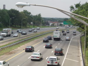
, has six lanes on the lower level and six lanes on the upper level. In addition to local traffic on Staten Island, the expressway provides the most direct route from Brooklyn and Long Island
to New Jersey. It is widely known throughout the New York area as one of the most congested roads in the city.
 After the Verrazano Narrows Bridge, I-278 continues into Brooklyn on the Gowanus Expressway. Immediately after the bridge, the freeway comes to an eastbound exit and westbound entrance for the Belt Parkway
. After this, a full interchange serves 92nd Street at which point I-278 becomes a single-level six-lane freeway. Along this road, one of the eastbound lanes serves as a high-occupancy vehicle lane. The Gowanus Expressway continues northeast into urban residential neighborhoods and reaches an eastbound interchange at Fort Hamilton Parkway and a westbound interchange at 86th Street. Turning more to the north, I-278 comes to a partial interchange at 65th Street, with an exit eastbound and entrance westbound. The road curves northwest at this point and comes to a directional interchange providing access to 3rd Avenue and the Belt Parkway. The Gowanus Expressway turns northeast again at this interchange and continues along an elevated alignment through urban residential and commercial areas. Along this viaduct, I-278 has interchanges with 38th Street/39th Street and the western terminus of NY 27
(Prospect Expressway). After the NY 27 interchange, the freeway widens to eight lanes and heads north, coming to an interchange with the Brooklyn-Battery Tunnel
approach (I-478), with the exit ramps splitting from the median of I-278. Westbound access to the tunnel is provided by the Hamilton Avenue exit.
 At this interchange, I-278 heads north onto the six-lane Brooklyn-Queens Expressway, passing through urban neighborhoods near downtown Brooklyn
on a depressed alignment. The next interchange the highway reaches serves Atlantic Avenue
. After Atlantic Avenue, the road runs along the East River
harbor in downtown Brooklyn and is partially covered to create the Brooklyn Heights Promenade. I-278 makes a sharp turn to the east away from the East River, maintained by the New York City Department of Transportation
, and comes to an interchange serving the Brooklyn Bridge
and Cadman Plaza. The freeway continues on an elevated alignment and makes a turn southeast as it comes to ramps accessing the Manhattan Bridge
. The highway becomes state maintained again and reaches at an exit serving Tillary Street and Flushing Avenue. At this point, the Brooklyn-Queens Expressway continues east through residential areas and turns northeast upon coming to the Wythe Avenue/Kent Avenue exit. The road passes through the Williamsburg
neighborhood on a depressed alignment, reaching an interchange that serves the Williamsburg Bridge
, with an exit at Metropolitan Avenue a short distance later. I-278 becomes elevated again as it passes through more neighborhoods and comes to the interchange with Humboldt Street/McGuinness Boulevard. The Brooklyn-Queens Expressway enters more industrial areas as it comes to Meeker Avenue/Morgan Avenue.
I-278 crosses the Newtown Creek
into Queens
on the Kosciuszko Bridge. Upon entering Queens, the Brooklyn-Queens Expressway runs north between residential neighborhoods to the east and Calvary Cemetery
to the west before coming to an interchange with I-495
. After I-495, the freeway makes a turn to the east, passing over homes before crossing over New Calvary Cemetery. The road turns northeast through more urban neighborhoods and reaches an interchange at NY 25
(Queens Boulevard
). At this point, I-278 becomes city maintained again and passes under the Long Island Rail Road
's Main Line
as it continues into a depressed alignment. The Brooklyn-Queens Expressway turns north as it comes to the exit for Broadway and Roosevelt Avenue. I-278 heads back onto a viaduct and comes to a single-point urban interchange
at NY 25A
. A short distance past NY 25A, the freeway has an eastbound exit and westbound entrance to the Grand Central Parkway
and 30th Avenue. I-278 narrows to four lanes as it merges into the Grand Central Parkway at an interchange that also has access to Astoria Boulevard
.
 I-278 turns west to run along the eight-lane state maintained Grand Central Parkway, with Astoria Boulevard (and Hoyt Avenue later on) serving as a frontage road. The frontage road serves as a truck route since large trucks are not permitted on the Grand Central. (Since November 2003, small trucks have been allowed on the Grand Central, an exception to the law prohibiting trucks on parkways in New York State.) The road runs along a depressed alignment, passing under Amtrak
's Northeast Corridor
. At the 31st Street interchange, the Grand Central Parkway overlap ends, and I-278 continues northwest as a eight-lane freeway over neighborhoods. The road crosses the Hell Gate
on the Robert F. Kennedy Bridge, maintained by the Triborough Bridge and Tunnel Authority, and comes onto Wards Island, which is a part of the borough of Manhattan
. On Wards Island, the road heads north through Wards Island Park and passes to the east of Manhattan Psychiatric Center as it heads onto Randall's Island
. I-278 comes to a toll plaza before an interchange that provides access to Franklin D. Roosevelt Drive by way of another segment of the Robert F. Kennedy Bridge over the Harlem River
. After this interchange, the Robert F. Kennedy Bridge carries the route over the Bronx Kill
into the Bronx
.
(Major Deegan Expressway
). At this point, the Bruckner Expressway heads northeast on a six-lane elevated alignment through industrial areas with some residences, paralleling the Northeast Corridor. Along this section, there is a westbound exit and eastbound entrance for 138th Street. I-895
splits from the eastbound direction of I-278 as the Bruckner Expressway makes a turn to the east into residential and commercial neighborhoods on a surface alignment, crossing the Bronx River
on a drawbridge
. The road has an interchange at Hunts Point Avenue before coming to the Bronx River Parkway
. Continuing east, the road has an exit serving White Plains Road and Castle Hill Avenue. I-278's eastern terminus is at the Bruckner Interchange
further to the east. Here, the Bruckner Expressway becomes I-95
and continues towards the New England Thruway
. At this interchange, I-278 also has access to I-295
, I-678
, and the Hutchinson River Parkway
.
Legally, the New York section of I-278 is defined as part of Interstate Route Connector 512 and all of Interstate Route Connector 518 in New York Highway Law § 340-a.
at the tripoint of Springfield
, Union Township
, and Millburn
. The western part of this planned freeway faced strong opposition. Even though it was to run along an abandoned railroad right-of-way, it would traverse through dense development in Roselle Park
, Kenilworth
, and Union Township, thereby making the project further disliked. By 1967, state officials decided not to pursue the continuation of I-278, and used the funds for I-278 to build I-195
across Central New Jersey instead. Meanwhile, I-278 was built between US 1/9 in Linden and the Goethals Bridge, opening to traffic in 1969 at a cost of $11.5 million.
The Union Freeway Extension was revived again, and was to start at US 1/9, but end at I-287
in Hanover Township
, following the Route 24 freeway between I-78 and I-287. Nevertheless, the Federal Highway Administration
rejected the proposal, thus ending the I-278 project.
 The Staten Island Expressway was first planned in 1941 as the Cross-Richmond Express Highway, a freeway connecting the Goethals and Verrazano bridges that was a part of a comprehensive system of freeways and parkways for the borough of Staten Island. In 1945, Robert Moses
took over planning for the freeway and called it the Clove Lakes Expressway. The plan received approval in stages through the mid 1950s and construction on the expressway began in 1959. By this time, the Staten Island Expressway had received the I-278 designation.
The construction of the Staten Island Expressway was particularly noted for the massive movement of earth required to build the section of the highway between Clove Road and Price Street (now Narrows Road North, a service road of the expressway) between Grymes Hill
and Emerson Hill
. The earth removed from the cut in the hill was placed in a remote section of central Staten Island adjacent to Sea View Hospital and has since been nicknamed "Moses Mountain," as a backhanded compliment to the highway's builder. Originally Moses intended for a spur of the expressway to follow the central ridge of the island, to connect with the Outerbridge Crossing
. But local opposition to this spur was tremendous, and unlike previous projects by Moses, it went down to defeat when Mayor John V. Lindsay took office in 1966; the southern half of this proposed spur did get built, however, and was opened for traffic as the Richmond Parkway, which was to have been the name of the entire roadway. The aborted section, from the Expressway to Richmond Avenue, has become part of the park system of New York City known as the Staten Island Greenbelt
. A ramp stub of an interchange on the expressway still exists along a wooded section of Todt Hill
. Part of the trail system of the Greenbelt uses the abandoned overpass bridge as pedestrian crossing of the Expressway.
The first link of the Staten Island Expressway opened in January 1964, from the Goethals Bridge
to Victory Boulevard. The remainder opened later that year. The freeway had a total cost of $47 million. In 1998, bus lanes were created on the eastern part of the Staten Island Expressway near the Verrazano Narrows Bridge; they were extended west to Todt Hill Road/Slosson Avenue in 2005. In 2008, the bus lanes were opened to high-occupancy vehicles during rush hours.
It was announced in July 2008 that a major project to improve the notoriously bad traffic conditions on the expressway is expected to commence in spring of 2010 at a cost of $50 million. Included in the project is the construction of six new on- and off-ramps, improvements to and relocations of existing on- and off-ramps, and other improvements to surrounding roads. This comes following numerous minor improvements to alleviate traffic, such as time/distance displays and designated bus lanes.
 The Gowanus Expressway was initially the Gowanus Parkway, first planned in the 1930s. Construction of the road, overseen by Robert Moses, started in 1939, with the parkway
being built on top of the BMT Third Avenue Line. The parkway was completed in 1941 and became part of a Belt Parkway that received the NY 27A
designation. The Gowanus Parkway was to be reconstructed into the Gowanus Expressway in the 1950s to connect the Verrazano Narrows Bridge to the Brooklyn-Battery Tunnel. This road was initially planned to be twelve lanes with a 3–3-3–3 configuration, but was reduced to six lanes to reduce disruption to the Bay Ridge
neighborhood. The Gowanus Expressway was incorporated into the Interstate Highway System and became a component of I-278. The improvements to the Gowanus Expressway into a six-lane freeway configuration was completed in 1964 with a $100 million price tag. The NY 27A designation was removed from the Gowanus Expressway by 1970.
By 2000, a high-occupancy vehicle lane was added to the eastbound Gowanus Expressway to serve traffic heading toward Manhattan. Over the years, the viaduct structure of the Gowanus Expressway has deteriorated. In 1998, a $16 million feasibility study for a tunnel
for the Gowanus Expressway was awarded. The New York State Department of Transportation is still considering putting the road in a tunnel.
 The Brooklyn-Queens Expressway was initially planned in 1936 as the Brooklyn-Queens Connecting Highway, a link between the Gowanus Parkway and the Triborough Bridge
(now Robert F. Kennedy Bridge). A part of the Brooklyn-Queens Connecting Highway opened in 1939 between Meeker Avenue and NY 25. In 1940, engineering mogul Robert Moses proposed an expressway between Queens and Brooklyn to relieve local streets of congestion from the Manhattan and Williamsburg Bridges. A section between the Williamsburg and Kosciuszko bridges opened in 1950; the road in its entirety was completed in 1964 at a cost of $137 million. Construction of the Brooklyn-Queens Expressway, overseen by Moses, tore through many residential neighborhoods in Brooklyn and Queens instead of following the East River.
In 1958, existing segments of the expressway were eligible for interstate highway funding. For a short time, the segment of highway between the Triborough Bridge and the Williamsburg Bridge was to be designated I-87 and continue north as the Major Deegan Expressway. By 1959, the I-278 designation was given to the entire length of the highway. Since the roadway was constructed prior to modern expressway standards, the road needed to be upgraded to meet standards. By the 1990s, a major muiltyear project begin in the 1980s brought upgrades to the Brooklyn-Queens Expressway. In 1999, a proposal surfaced to put the Brooklyn-Queens Expressway in a tunnel. In the 2000s, the expressway underwent another upgrade project that replaced many bridges along the route.
The brief portion of I-278 that follows the Grand Central Parkway between the Brooklyn-Queens Expressway and the Robert F. Kennedy Bridge opened in the 1930s.
. In the 1930s, a freeway was planned on the Bruckner Boulevard alignment in order to provide a connection between the Triborough Bridge and a freeway leading north into Westchester County
. Robert Moses took over planning for the road in 1951 and called for an elevated freeway between the Triborough Bridge and the Bronx River and a depressed freeway east of there. Construction on the elevated Bruckner Expressway began in 1957 while it started on the depressed segment in 1959. The depressed portion was opened in 1961 while the elevated portion of the Bruckner Expressway was opened in 1962. In 1972, the large Bruckner Interchange was finished, completing the route.
Over the years, the I-278 portion of the Bruckner Expressway has had different designations. When the Interstate Highway System was first created, the road was to be part of I-895 from I-87 to the Sheridan Expressway and I-678 from there to I-95. Later, I-278 was planned to follow the Bruckner Expressway from I-87 to the Sheridan Expressway, where it would continue on that freeway to I-95, while the Bruckner Expressway was not designated an interstate north of there. By 1970, I-278 was aligned onto its current alignment, with I-895 created along the Sheridan Expressway.
!rowspan=2|County
!rowspan=2|Location
!rowspan=2|Mile
!colspan=2|Exit
!rowspan=2|Destinations
!rowspan=2|Notes
|-
!Old
!
|-
|rowspan=3|Union
|rowspan=1|Linden
|0.00
|
|1
|
|Westbound exit and eastbound entrance
|-
|rowspan=2|Elizabeth
|1.01
|
|2
|
|
|-
|1.20
|
|3
|
|NJTP exit 13
|-
|colspan=7 align="center"|New York
– New Jersey
state line on Goethals Bridge
over Arthur Kill
|-
|rowspan=14|Richmond
|rowspan=14|Staten Island
|-
|1.60
|
|3
|Western Avenue
|Westbound exit and eastbound entrance
|-
|1.70
|
|4
|Forest Avenue
|Eastbound exit and westbound entrance
|-
|1.83
|
|5
| (West Shore Expressway) – Outerbridge Crossing
|West end of NY 440 overlap
|-
|1.90
|
|6
|South Avenue
|Westbound exit and eastbound entrance
|-
|2.04
|
|7
|Richmond Avenue
|
|-
|2.74
|
|8
|Victory Boulevard
|Eastbound exit and westbound entrance
|-
|2.93
|
|9
| (Dr. Martin Luther King, Jr. Expressway) – Bayonne Bridge
|East end of NY 440 overlap
|-
|2.74
|
|10
|Victory Boulevard
|Westbound exit and eastbound entrance
|-
|3.44
|
|11
|Bradley Avenue
|
|-
|4.78
|
|12
|Todt Hill Road
/ Slosson Avenue
|
|-
|5.73
|
|13
|Clove Road
/ Richmond Road
/ Targee Street
/ Hylan Boulevard
|
|-
|7.34
|
|14
|Narrows Road west / Fingerboard Road
/ Hylan Boulevard
|Westbound exit and eastbound entrance
|-
|7.58
|
|15
|Lily Pond Avenue / Bay Street – South Beach
|Signed westbound as 15S and 15N
|-
|colspan=7 align="center" |Verrazano-Narrows Bridge
over The Narrows
|-
|rowspan=23|Kings
|rowspan=23|Brooklyn
|-
|8.64
|
|
|
|Eastbound exit and westbound entrance
|-
|9.84
|
|17
|92nd Street - Bay Ridge
|
|-
|10.47
|
|18
|Fort Hamilton Parkway
|Eastbound exit and westbound entrance
|-
|10.89
|
|19
|86th Street
|Westbound exit and eastbound entrance
|-
|11.18
|
|20
|7th Avenue / 65th Street / 6th Avenue
|
|-
|11.93
|
|21
|3rd Avenue
|Eastbound exit and westbound entrance
|-
|12.65
|
|22
|
|Westbound exit and eastbound entrance
|-
|13.92
|
|23
|38th Street / 39th Street
|No entrance ramps
|-
|14.29
|
|24
| (Prospect Expressway)
|
|-
|15.06
|26A
|25
|Battery Tunnel (I-478) – Manhattan
|Eastbound exit and westbound entrance
Westbound exit is via exit 26
|-
|15.14
|26B
|26
|Hamilton Avenue
|Signed westbound for Battery Tunnel – Manhattan
|-
|16.12
|
|27
|Atlantic Avenue
|
|-
|16.74
|
|28A
|Cadman Plaza West
|Signed as exit 28 westbound
|-
|17.20
|
|28B
|Brooklyn Bridge
|Westbound exit is via exit 28
|-
|17.47
|
|29A
|Manhattan Bridge
|Westbound exit is via exit 29
|-
|18.10
|
|29B
|Tillary Street – Brooklyn Civic Center
|Signed as exit 29 westbound
|-
|18.68
|
|30
|Flushing Avenue
|Eastbound exit and westbound entrance
|-
|19.32
|
|31
|Wythe Avenue / Kent Avenue
|Westbound exit and eastbound entrance
|-
|19.85
|
|32A
|Williamsburg Bridge
– Manhattan
|Eastbound exit is via exit 32
|-
|20.41
|
|32B
|Metropolitan Avenue
|Signed as exit 32 eastbound
|-
|20.60
|
|33
|Humboldt Street / McGuinness Boulevard
|Eastbound exit and westbound entrance
|-
|21.80
|
|34
|Meeker Avenue / Morgan Avenue
|Westbound exit and eastbound entrance
|-
|rowspan=9|Queens
|rowspan=9|Queens
|22.02
|
|35
|
|
|-
|23.30
|36
|39
|
|Signed as exits 39E (east) and 39W (west) westbound
|-
|23.87
|37
|40
|Broadway / Roosevelt Avenue
|
|-
|24.48
|38
|41
|
|
|-
|24.66
|39
|42
|
|Eastbound exit and westbound entrance
|-
|25.31
|40
|43
|30th Avenue
|Eastbound exit and westbound entrance
|-
|25.57
|41
|44
|Astoria Boulevard
west
|Eastbound exit and westbound entrance
|-
|26.01
|
|
|
|Westbound exit and eastbound entrance
|-
|26.37
|3
|45
|31st Street / Astoria Boulevard
|Astoria Boulevard not signed on southbound
|-
|colspan=7 align="center"|Robert F. Kennedy Bridge (west span) over East River
|-
|rowspan=2|New York
|rowspan=2|Manhattan
|-
|28.18
|
|46
|
|
|-
|colspan=7 align="center"|Robert F. Kennedy Bridge (east span) over Hell Gate
|-
|rowspan=11|Bronx
|rowspan=11|The Bronx
|-
|28.89
|44
|47
|
|
|-
|
|45
|48
|East 138th Street
|Westbound entrance closed
|-
|30.78
|46
|49
|
|Eastbound exit and westbound entrance
|-
|
|
|50
|Hunts Point Avenue – Hunts Point Market
|Westbound exit and eastbound entrance
|-
|
|
|51
|Bronx River Avenue
|Westbound exit only
|-
|31.58
|
|51
|
|No westbound exit
|-
|32.35
|
|52
|White Plains Road / Castle Hill Avenue
|
|-
|-
|rowspan=2|33.62
|
|
|
|Eastbound exit and westbound entrance
|-
|
|
|
|Eastbound exit and westbound entrance
|-
New Jersey
New Jersey is a state in the Northeastern and Middle Atlantic regions of the United States. , its population was 8,791,894. It is bordered on the north and east by the state of New York, on the southeast and south by the Atlantic Ocean, on the west by Pennsylvania and on the southwest by Delaware...
and New York
New York
New York is a state in the Northeastern region of the United States. It is the nation's third most populous state. New York is bordered by New Jersey and Pennsylvania to the south, and by Connecticut, Massachusetts and Vermont to the east...
, United States
United States
The United States of America is a federal constitutional republic comprising fifty states and a federal district...
. The road runs 35.62 miles (57.32 km) from U.S. Route 1/9 (US 1/9) in Linden, New Jersey
Linden, New Jersey
- Local government :, the Mayor of Linden is . The former longtime Mayor of Linden is 82-year-old John T. Gregorio, who served as mayor of Linden for 30, nonconsecutive years and was repeatedly tagged with scandal during his mayoral career, including one felony conviction, later pardoned, which...
to the Bruckner Interchange
Bruckner Interchange
The Bruckner Interchange is a complex interchange at the intersection of the Bruckner Expressway, Cross Bronx Expressway, Hutchinson River Expressway, and Hutchinson River Parkway in the New York City borough of the Bronx, United States...
in the New York City
New York City
New York is the most populous city in the United States and the center of the New York Metropolitan Area, one of the most populous metropolitan areas in the world. New York exerts a significant impact upon global commerce, finance, media, art, fashion, research, technology, education, and...
borough of the Bronx
The Bronx
The Bronx is the northernmost of the five boroughs of New York City. It is also known as Bronx County, the last of the 62 counties of New York State to be incorporated...
. It serves as a partial beltway through the eastern section of New York City and passes through all five of the city's borough
Borough (New York City)
New York City, one of the largest cities in the world, is composed of five boroughs. Each borough now has the same boundaries as the county it is in. County governments were dissolved when the city consolidated in 1898, along with all city, town, and village governments within each county...
s (though through Manhattan
Manhattan
Manhattan is the oldest and the most densely populated of the five boroughs of New York City. Located primarily on the island of Manhattan at the mouth of the Hudson River, the boundaries of the borough are identical to those of New York County, an original county of the state of New York...
only because the Robert F. Kennedy Bridge crosses Wards Island, which is part of Manhattan). The majority of I-278 is in New York City. I-278 follows several freeways, including the Union Freeway in Union County, New Jersey
Union County, New Jersey
Union County is a county located in the U.S. state of New Jersey. As of the 2010 Census, the population was 536,499. It is part of the New York Metropolitan Area. Its county seat is Elizabeth. Union County ranks 93rd among the highest-income counties in the United States. It also ranks 74th in...
, the Staten Island Expressway (SIE) across Staten Island
Staten Island
Staten Island is a borough of New York City, New York, United States, located in the southwest part of the city. Staten Island is separated from New Jersey by the Arthur Kill and the Kill Van Kull, and from the rest of New York by New York Bay...
, the Gowanus Expressway in southern Brooklyn, the Brooklyn-Queens Expressway (BQE) across northern Brooklyn and Queens, a small part of the Grand Central Parkway in Queens, and a part of the Bruckner Expressway
Bruckner Expressway
The Bruckner Expressway is a freeway in The Bronx. It carries Interstate 278 and Interstate 95 from the Robert F. Kennedy Bridge to the south end of the New England Thruway at the Pelham Parkway interchange....
in the Bronx. I-278 also crosses multiple bridges, including the Goethals Bridge
Goethals Bridge
The Goethals Bridge connects Elizabeth, New Jersey to Staten Island , near the Howland Hook Marine Terminal, Staten Island, New York over the Arthur Kill. Operated by the Port Authority of New York and New Jersey, the span was one of the first structures built by the authority...
between New Jersey and Staten Island, the Verrazano Narrows Bridge between Staten Island and Brooklyn, the Kosciuszko Bridge
Kosciuszko Bridge (New York City)
The Kosciuszko Bridge is a truss bridge that spans Newtown Creek between the New York City boroughs of Brooklyn and Queens, connecting Greenpoint, Brooklyn and Maspeth, Queens. It is a part of Interstate 278, which is also locally known as the Brooklyn-Queens Expressway...
between Brooklyn and Queens, and the Robert F. Kennedy Bridge.
Despite its number, I-278 does not connect to I-78
Interstate 78
Interstate 78 is an Interstate Highway in the Northeast United States, running 144 miles from Interstate 81 northeast of Harrisburg, Pennsylvania, through Allentown, Pennsylvania, and western and northern New Jersey to the Holland Tunnel and Lower Manhattan in New York City.I-78 is a major road...
; however, there were once plans to extend I-278 west to I-78 east of the Route 24
Route 24 (New Jersey)
Route 24 is a state highway in New Jersey, United States, that extends from a junction with Interstate 287 in Hanover Township in Morris County, passing southeast through Essex County, and ends at a junction with Interstate 78 in Springfield Township in Union County. The route is a four- to...
interchange in Springfield, New Jersey
Springfield Township, Union County, New Jersey
Township of Springfield is a township in Union County, New Jersey, United States. As of the 2010 United States Census, the township population increased to a record high of 15,817....
. This was cancelled due to opposition from the communities along the route. The segment that does exist in New Jersey was opened in 1969. There were also plans to extend I-78 east across Manhattan and into Brooklyn via the Williamsburg Bridge
Williamsburg Bridge
The Williamsburg Bridge is a suspension bridge in New York City across the East River connecting the Lower East Side of Manhattan at Delancey Street with the Williamsburg neighborhood of Brooklyn at Broadway near the Brooklyn-Queens Expressway...
; this would have been a second location where the two highways would have interchanged, but these plans were also thwarted. In New York, the various parts of I-278 were planned by Robert Moses
Robert Moses
Robert Moses was the "master builder" of mid-20th century New York City, Long Island, Rockland County, and Westchester County, New York. As the shaper of a modern city, he is sometimes compared to Baron Haussmann of Second Empire Paris, and is one of the most polarizing figures in the history of...
, an urban planner in New York City. Some of these completed segments predated the Interstate Highway System and are thus not up to standards. Over the years, portions of I-278 have required upgrading. In addition, they tore through many New York City neighborhoods, causing controversy. All of I-278 through New York City was completed by the 1960s. I-87
Interstate 87
Interstate 87 is a Interstate Highway located entirely within New York State in the United States of America. I-87 is the longest intrastate Interstate highway in the Interstate Highway System. Its southern end is at the Bronx approaches of the Robert F. Kennedy Bridge in New York City...
was once planned to follow the segment of I-278 between the Williamsburg Bridge
Williamsburg Bridge
The Williamsburg Bridge is a suspension bridge in New York City across the East River connecting the Lower East Side of Manhattan at Delancey Street with the Williamsburg neighborhood of Brooklyn at Broadway near the Brooklyn-Queens Expressway...
and the Major Deegan Expressway
Major Deegan Expressway
The Major Deegan Expressway is a north–south expressway in the New York City borough of the Bronx...
, but this ultimately became a part of I-278. In addition, the Bruckner Expressway portion of I-278 had been designated with different route numbers. At first, it was to be I-895
Interstate 895 (New York)
Interstate 895 , named the Arthur V. Sheridan Expressway, is a short freeway in the New York City borough of the Bronx, forming a short connecting link in the Interstate Highway System...
between I-87 and the Sheridan Expressway and I-678
Interstate 678
Interstate 678 is a north–south auxiliary Interstate Highway that extends for through two boroughs of New York City. The route begins at John F. Kennedy International Airport on Jamaica Bay and travels north through Queens and across the East River to the Bronx, where it ends at...
past there. Later, I-278 was planned to follow the Bruckner Expressway and the Sheridan Expressway to I-95 (with no route number for the Bruckner Expressway past there) before the current numbering took place by 1970, with I-895 designated onto the Sheridan Expressway.
New Jersey
|-|NJ
New Jersey
New Jersey is a state in the Northeastern and Middle Atlantic regions of the United States. , its population was 8,791,894. It is bordered on the north and east by the state of New York, on the southeast and south by the Atlantic Ocean, on the west by Pennsylvania and on the southwest by Delaware...
|| 2.00|| 3.22
|-
|NY
New York
New York is a state in the Northeastern region of the United States. It is the nation's third most populous state. New York is bordered by New Jersey and Pennsylvania to the south, and by Connecticut, Massachusetts and Vermont to the east...
|| 33.62 || 54.11
|-
|Total || 35.62 || 57.32
|}
The New Jersey segment of I-278 begins in Linden
Linden, New Jersey
- Local government :, the Mayor of Linden is . The former longtime Mayor of Linden is 82-year-old John T. Gregorio, who served as mayor of Linden for 30, nonconsecutive years and was repeatedly tagged with scandal during his mayoral career, including one felony conviction, later pardoned, which...
, Union County
Union County, New Jersey
Union County is a county located in the U.S. state of New Jersey. As of the 2010 Census, the population was 536,499. It is part of the New York Metropolitan Area. Its county seat is Elizabeth. Union County ranks 93rd among the highest-income counties in the United States. It also ranks 74th in...
at the junction with US 1/9
U.S. Route 1/9
U.S. Route 9 is a U.S. highway in the northeast United States, running from Laurel, Delaware north to the Canadian border near Champlain, New York...
, where it merges into the southbound direction of that road. The freeway heads east and carries two lanes in each direction, with the eastbound direction widening to three lanes. I-278 runs between urban residential areas to the north and the Bayway Refinery
Bayway Refinery
Bayway Refinery is a refining facility in the Port of New York and New Jersey, owned by ConocoPhillips. Located in Linden and Elizabeth, New Jersey, it is the northernmost refinery on the East Coast of the United States. The oil refinery converts crude oil into gasoline, diesel fuel, jet fuel, and...
to the south as it continues into Elizabeth
Elizabeth, New Jersey
Elizabeth is a city in Union County, New Jersey, United States. As of the 2010 United States Census, the city had a total population of 124,969, retaining its ranking as New Jersey's fourth largest city with an increase of 4,401 residents from its 2000 Census population of 120,568...
. In this area, the road meets Route 439
Route 439 (New Jersey)
Route 439 is a short state highway in the communities of Linden and Elizabeth in Union County, New Jersey. The highway is known as the Bayway, North Avenue and Elmora Avenue from the Goethals Bridge and Interstate 278 in Linden and does a loop around Elizabeth, with the designation terminating at...
and the New Jersey Turnpike
New Jersey Turnpike
The New Jersey Turnpike is a toll road in New Jersey, maintained by the New Jersey Turnpike Authority. According to the International Bridge, Tunnel and Turnpike Association, the Turnpike is the nation's sixth-busiest toll road and is among one of the most heavily traveled highways in the United...
(I-95
Interstate 95 in New Jersey
Interstate 95 is a major Interstate Highway that traverses the full extent of the East Coast of the United States, from Florida to Maine...
) at the only intermediate interchange that I-278 has in New Jersey. This short length is sometimes called the Union Freeway. After the New Jersey Turnpike, I-278 turns southeast and crosses the Arthur Kill
Arthur Kill
The Arthur Kill is a tidal strait separating Staten Island, New York from mainland New Jersey, USA, and a major navigational channel of the Port of New York and New Jersey. Kill is from the Middle Dutch word kille, meaning "riverbed" or "water channel"...
on the four-lane Goethals Bridge
Goethals Bridge
The Goethals Bridge connects Elizabeth, New Jersey to Staten Island , near the Howland Hook Marine Terminal, Staten Island, New York over the Arthur Kill. Operated by the Port Authority of New York and New Jersey, the span was one of the first structures built by the authority...
to Staten Island, a borough
Borough (New York City)
New York City, one of the largest cities in the world, is composed of five boroughs. Each borough now has the same boundaries as the county it is in. County governments were dissolved when the city consolidated in 1898, along with all city, town, and village governments within each county...
of New York City
New York City
New York is the most populous city in the United States and the center of the New York Metropolitan Area, one of the most populous metropolitan areas in the world. New York exerts a significant impact upon global commerce, finance, media, art, fashion, research, technology, education, and...
. This bridge is maintained by the Port Authority of New York and New Jersey
Port Authority of New York and New Jersey
The Port Authority of New York and New Jersey is a bi-state port district, established in 1921 through an interstate compact, that runs most of the regional transportation infrastructure, including the bridges, tunnels, airports, and seaports, within the Port of New York and New Jersey...
.
Staten Island Expressway
New York State Department of Transportation
The New York State Department of Transportation is responsible for the development and operation of highways, railroads, mass transit systems, ports, waterways and aviation facilities in the U.S...
, coming to an exit for Western Avenue and Forest Avenue before reaching a directional interchange with NY 440
New York State Route 440
New York State Route 440 is a state highway located entirely on Staten Island in New York City. The route acts as a connector between the two segments of New Jersey Route 440, running from the Staten Island community of Richmond Valley to the south to Port Richmond to the north...
(West Shore Expressway). NY 440 forms a concurrency
Concurrency (road)
A concurrency, overlap, or coincidence in a road network is an instance of one physical road bearing two or more different highway, motorway, or other route numbers...
with I-278 and the road heads into residential neighborhoods. The road carries four lanes eastbound and three lanes westbound as it comes to the exit serving Richmond Avenue
Richmond Avenue
Richmond Avenue is an integral north-south thoroughfare on Staten Island. Measuring approximately 7.0 miles , the road runs from the community of Graniteville to the south shore community of Eltingville.- Street description :...
. Immediately after, NY 440 splits from the Staten Island Expressway at a large interchange, heading north on the Dr. Martin Luther King Jr. Expressway. This interchange also provides access to Victory Boulevard. The six-lane I-278 turns to the east past this point, with Gannon Avenue serving as a frontage road
Frontage road
A frontage road is a non-limited access road running parallel to a higher-speed road, usually a freeway, and feeding it at appropriate points of access...
, and reaches the Bradley Avenue exit.
The next interchange the Staten Island Expressway is with Todt Hill Road and Slosson Avenue. At this interchange, the freeway gains a bus lane
Bus lane
A bus lane or bus only lane is a lane restricted to buses, and generally used to speed up public transport that would be otherwise held up by traffic congestion...
in each direction that also serves as a high-occupancy vehicle lane
High-occupancy vehicle lane
In transportation engineering and transportation planning, a high-occupancy vehicle lane is a lane reserved for vehicles with a driver and one or more passengers...
during rush hours. After Todt Hill Road, I-278 runs through a wooded area where it comes to an incomplete interchange that was to be the northern terminus of the Richmond Parkway. The road continues back into residential areas and comes to an interchange serving Clove Road and Richmond Road. The next interchange the freeway has is with Hylan Boulevard
Hylan Boulevard
Hylan Boulevard is a major northeast-southwest boulevard in the New York City borough of Staten Island. It is approximately long , and runs from the North Shore neighborhood of Rosebank to the South Shore neighborhood of Tottenville....
. A short distance later, the Staten Island Expressway comes to a large interchange that serves Lily Pond Road and Bay Street. Immediately after, I-278 reaches the toll plaza for the Verrazano Narrows Bridge. Following the toll plaza, I-278 goes onto the Verrazano Narrows Bridge linking to Brooklyn over the Narrows
The Narrows
The Narrows is the tidal strait separating the boroughs of Staten Island and Brooklyn in New York City. It connects the Upper New York Bay and Lower New York Bay and forms the principal channel by which the Hudson River empties into the Atlantic Ocean...
. This bridge, which is maintained by the Triborough Bridge and Tunnel Authority
Triborough Bridge and Tunnel Authority
MTA Bridges and Tunnels, legal name Triborough Bridge and Tunnel Authority, is a division of the Metropolitan Transportation Authority, that operates seven intrastate toll bridges and two tunnels in New York City...
, has six lanes on the lower level and six lanes on the upper level. In addition to local traffic on Staten Island, the expressway provides the most direct route from Brooklyn and Long Island
Long Island
Long Island is an island located in the southeast part of the U.S. state of New York, just east of Manhattan. Stretching northeast into the Atlantic Ocean, Long Island contains four counties, two of which are boroughs of New York City , and two of which are mainly suburban...
to New Jersey. It is widely known throughout the New York area as one of the most congested roads in the city.
Gowanus Expressway
Belt Parkway
The Belt System is a series of connected limited-access highways that form a belt-like circle around the New York City boroughs of Brooklyn and Queens. The system comprises four officially separate parkways; however, three of the four are signed as the Belt Parkway...
. After this, a full interchange serves 92nd Street at which point I-278 becomes a single-level six-lane freeway. Along this road, one of the eastbound lanes serves as a high-occupancy vehicle lane. The Gowanus Expressway continues northeast into urban residential neighborhoods and reaches an eastbound interchange at Fort Hamilton Parkway and a westbound interchange at 86th Street. Turning more to the north, I-278 comes to a partial interchange at 65th Street, with an exit eastbound and entrance westbound. The road curves northwest at this point and comes to a directional interchange providing access to 3rd Avenue and the Belt Parkway. The Gowanus Expressway turns northeast again at this interchange and continues along an elevated alignment through urban residential and commercial areas. Along this viaduct, I-278 has interchanges with 38th Street/39th Street and the western terminus of NY 27
New York State Route 27
New York State Route 27 is an east–west long state highway extending from Interstate 278 in the New York City borough of Brooklyn to Montauk Point State Park on Long Island, New York, United States...
(Prospect Expressway). After the NY 27 interchange, the freeway widens to eight lanes and heads north, coming to an interchange with the Brooklyn-Battery Tunnel
Brooklyn-Battery Tunnel
Interstate 478s entire length consists of the Brooklyn–Battery Tunnel and its approaches. Its south end is at Interstate 278, and its north end is at NY 9A ....
approach (I-478), with the exit ramps splitting from the median of I-278. Westbound access to the tunnel is provided by the Hamilton Avenue exit.
Brooklyn-Queens Expressway
Downtown Brooklyn
Downtown Brooklyn is the third largest central business district in New York City , and is located in the northwestern section of the borough of Brooklyn...
on a depressed alignment. The next interchange the highway reaches serves Atlantic Avenue
Atlantic Avenue (New York City)
Atlantic Avenue is an important street in the New York City boroughs of Brooklyn and Queens. It stretches from the Brooklyn waterfront on the East River all the way to Jamaica, Queens...
. After Atlantic Avenue, the road runs along the East River
East River
The East River is a tidal strait in New York City. It connects Upper New York Bay on its south end to Long Island Sound on its north end. It separates Long Island from the island of Manhattan and the Bronx on the North American mainland...
harbor in downtown Brooklyn and is partially covered to create the Brooklyn Heights Promenade. I-278 makes a sharp turn to the east away from the East River, maintained by the New York City Department of Transportation
New York City Department of Transportation
The New York City Department of Transportation is responsible for the management of much of New York City's transportation infrastructure...
, and comes to an interchange serving the Brooklyn Bridge
Brooklyn Bridge
The Brooklyn Bridge is one of the oldest suspension bridges in the United States. Completed in 1883, it connects the New York City boroughs of Manhattan and Brooklyn by spanning the East River...
and Cadman Plaza. The freeway continues on an elevated alignment and makes a turn southeast as it comes to ramps accessing the Manhattan Bridge
Manhattan Bridge
The Manhattan Bridge is a suspension bridge that crosses the East River in New York City, connecting Lower Manhattan with Brooklyn . It was the last of the three suspension bridges built across the lower East River, following the Brooklyn and the Williamsburg bridges...
. The highway becomes state maintained again and reaches at an exit serving Tillary Street and Flushing Avenue. At this point, the Brooklyn-Queens Expressway continues east through residential areas and turns northeast upon coming to the Wythe Avenue/Kent Avenue exit. The road passes through the Williamsburg
Williamsburg, Brooklyn
Williamsburg is a neighborhood in the New York City borough of Brooklyn, bordering Greenpoint to the north, Bedford-Stuyvesant to the south, Bushwick to the east and the East River to the west. The neighborhood is part of Brooklyn Community Board 1. The neighborhood is served by the NYPD's 90th ...
neighborhood on a depressed alignment, reaching an interchange that serves the Williamsburg Bridge
Williamsburg Bridge
The Williamsburg Bridge is a suspension bridge in New York City across the East River connecting the Lower East Side of Manhattan at Delancey Street with the Williamsburg neighborhood of Brooklyn at Broadway near the Brooklyn-Queens Expressway...
, with an exit at Metropolitan Avenue a short distance later. I-278 becomes elevated again as it passes through more neighborhoods and comes to the interchange with Humboldt Street/McGuinness Boulevard. The Brooklyn-Queens Expressway enters more industrial areas as it comes to Meeker Avenue/Morgan Avenue.
I-278 crosses the Newtown Creek
Newtown Creek
Newtown Creek is a estuary that forms part of the border between the boroughs of Brooklyn and Queens, in New York City, New York, United States. It derives its name from New Town , which was the name for the Dutch and British settlement in what is now Elmhurst, Queens...
into Queens
Queens
Queens is the easternmost of the five boroughs of New York City. The largest borough in area and the second-largest in population, it is coextensive with Queens County, an administrative division of New York state, in the United States....
on the Kosciuszko Bridge. Upon entering Queens, the Brooklyn-Queens Expressway runs north between residential neighborhoods to the east and Calvary Cemetery
Calvary Cemetery, Queens
The Roman Catholic Calvary Cemetery in Queens has the largest number of interments of any cemetery in the United States.The offices of Calvary Cemetery are located at 49-02 Laurel Hill Blvd. in Woodside in the New York City borough of Queens, New York. The cemetery is managed by the Trustees of...
to the west before coming to an interchange with I-495
Interstate 495 (New York)
Interstate 495 is an auxiliary Interstate Highway on Long Island in New York in the United States. The route extends for from the western portal of the Queens-Midtown Tunnel in the New York City borough of Manhattan to County Route 58 in Riverhead, Suffolk County...
. After I-495, the freeway makes a turn to the east, passing over homes before crossing over New Calvary Cemetery. The road turns northeast through more urban neighborhoods and reaches an interchange at NY 25
New York State Route 25
New York State Route 25 is an east–west state highway in downstate New York in the United States. The route extends for just over from east midtown Manhattan in New York City to the Cross Sound Ferry terminal at Orient Point on the end of Long Island's North Fork...
(Queens Boulevard
Queens Boulevard
Queens Boulevard is a major thoroughfare in the New York City boroughs of Manhattan and Queens connecting communities from Midtown Manhattan to Jamaica...
). At this point, I-278 becomes city maintained again and passes under the Long Island Rail Road
Long Island Rail Road
The Long Island Rail Road or LIRR is a commuter rail system serving the length of Long Island, New York. It is the busiest commuter railroad in North America, serving about 81.5 million passengers each year. Established in 1834 and having operated continuously since then, it is the oldest US...
's Main Line
Main Line (Long Island Rail Road)
The Main Line is a rail line owned and operated by the Long Island Rail Road in the U.S. state of New York. It begins in Long Island City and runs along the middle of Long Island about 95 miles to Greenport...
as it continues into a depressed alignment. The Brooklyn-Queens Expressway turns north as it comes to the exit for Broadway and Roosevelt Avenue. I-278 heads back onto a viaduct and comes to a single-point urban interchange
Single-point urban interchange
A single-point urban interchange , also called a single-point interchange or single-point diamond interchange , is a type of highway interchange...
at NY 25A
New York State Route 25A
New York State Route 25A is a state highway on Long Island in New York in the United States. It serves as the main east–west route for most of the North Shore of Long Island, running from the Queens Midtown Tunnel in the New York City borough of Queens at its western terminus to...
. A short distance past NY 25A, the freeway has an eastbound exit and westbound entrance to the Grand Central Parkway
Grand Central Parkway
The Grand Central Parkway is a parkway that stretches from the RFK-Triborough Bridge in New York City to Nassau County on Long Island. At the Queens-Nassau border, it becomes the Northern State Parkway, which runs across the northern part of Long Island through Nassau County and into Suffolk...
and 30th Avenue. I-278 narrows to four lanes as it merges into the Grand Central Parkway at an interchange that also has access to Astoria Boulevard
Astoria Boulevard
Astoria Boulevard is an important east-west commercial street in northwestern Queens, New York City. It runs from 21st Street and Main Avenue near the East River to the World's Fair Marina on Flushing Bay, where it merges with Northern Boulevard....
.
Grand Central Parkway and Robert F. Kennedy Bridge
Amtrak
The National Railroad Passenger Corporation, doing business as Amtrak , is a government-owned corporation that was organized on May 1, 1971, to provide intercity passenger train service in the United States. "Amtrak" is a portmanteau of the words "America" and "track". It is headquartered at Union...
's Northeast Corridor
Northeast Corridor
The Northeast Corridor is a fully electrified railway line owned primarily by Amtrak serving the Northeast megalopolis of the United States from Boston in the north, via New York to Washington, D.C. in the south, with branches serving other cities...
. At the 31st Street interchange, the Grand Central Parkway overlap ends, and I-278 continues northwest as a eight-lane freeway over neighborhoods. The road crosses the Hell Gate
Hell Gate
Hell Gate is a narrow tidal strait in the East River in New York City in the United States. It separates Astoria, Queens from Randall's Island/Wards Island ....
on the Robert F. Kennedy Bridge, maintained by the Triborough Bridge and Tunnel Authority, and comes onto Wards Island, which is a part of the borough of Manhattan
Manhattan
Manhattan is the oldest and the most densely populated of the five boroughs of New York City. Located primarily on the island of Manhattan at the mouth of the Hudson River, the boundaries of the borough are identical to those of New York County, an original county of the state of New York...
. On Wards Island, the road heads north through Wards Island Park and passes to the east of Manhattan Psychiatric Center as it heads onto Randall's Island
Randall's Island
Randall's Island is situated in the East River in New York City, part of the borough of Manhattan. It is separated from Manhattan island on the west by the river's main channel, from Queens on the east by the Hell Gate, and from the Bronx on the north by the Bronx Kill. It is joined to Wards...
. I-278 comes to a toll plaza before an interchange that provides access to Franklin D. Roosevelt Drive by way of another segment of the Robert F. Kennedy Bridge over the Harlem River
Harlem River
The Harlem River is a navigable tidal strait in New York City, USA that flows 8 miles between the Hudson River and the East River, separating the boroughs of Manhattan and the Bronx...
. After this interchange, the Robert F. Kennedy Bridge carries the route over the Bronx Kill
Bronx Kill
The Bronx Kill is a narrow strait in New York City delineating the southernmost extent of the Bronx and separating it from Randall's Island. It connects the Harlem River to the East River.-History:...
into the Bronx
The Bronx
The Bronx is the northernmost of the five boroughs of New York City. It is also known as Bronx County, the last of the 62 counties of New York State to be incorporated...
.
Bruckner Expressway
In the Bronx, I-278 becomes the Bruckner Expressway and reaches an interchange with the southern terminus of I-87Interstate 87
Interstate 87 is a Interstate Highway located entirely within New York State in the United States of America. I-87 is the longest intrastate Interstate highway in the Interstate Highway System. Its southern end is at the Bronx approaches of the Robert F. Kennedy Bridge in New York City...
(Major Deegan Expressway
Major Deegan Expressway
The Major Deegan Expressway is a north–south expressway in the New York City borough of the Bronx...
). At this point, the Bruckner Expressway heads northeast on a six-lane elevated alignment through industrial areas with some residences, paralleling the Northeast Corridor. Along this section, there is a westbound exit and eastbound entrance for 138th Street. I-895
Interstate 895 (New York)
Interstate 895 , named the Arthur V. Sheridan Expressway, is a short freeway in the New York City borough of the Bronx, forming a short connecting link in the Interstate Highway System...
splits from the eastbound direction of I-278 as the Bruckner Expressway makes a turn to the east into residential and commercial neighborhoods on a surface alignment, crossing the Bronx River
Bronx River
The Bronx River, approximately long, flows through southeast New York in the United States. It is named after colonial settler Jonas Bronck. The Bronx River is the only fresh water river in New York City....
on a drawbridge
Drawbridge
A drawbridge is a type of movable bridge typically associated with the entrance of a castle surrounded by a moat. The term is often used to describe all different types of movable bridges, like bascule bridges and lift bridges.-Castle drawbridges:...
. The road has an interchange at Hunts Point Avenue before coming to the Bronx River Parkway
Bronx River Parkway
The Bronx River Parkway is a long parkway in downstate New York. It is named for the nearby Bronx River, which it parallels. The southern terminus of the parkway is at Story Avenue near Bruckner Expressway in the Bronx neighborhood of Soundview...
. Continuing east, the road has an exit serving White Plains Road and Castle Hill Avenue. I-278's eastern terminus is at the Bruckner Interchange
Bruckner Interchange
The Bruckner Interchange is a complex interchange at the intersection of the Bruckner Expressway, Cross Bronx Expressway, Hutchinson River Expressway, and Hutchinson River Parkway in the New York City borough of the Bronx, United States...
further to the east. Here, the Bruckner Expressway becomes I-95
Interstate 95 in New York
Interstate 95 is a part of the Interstate Highway System that runs from Miami, Florida, to the Canada – United States border near Houlton, Maine. In the U.S. state of New York, I-95 extends from the George Washington Bridge in New York City to the Connecticut state line at Port Chester...
and continues towards the New England Thruway
New England Thruway
The New England Thruway is a portion of the U.S. Interstate highway system and of the New York State Thruway, within and operated by the New York State Thruway Authority, linking New York City with New England, specifically with southwestern Connecticut...
. At this interchange, I-278 also has access to I-295
Interstate 295 (New York)
Interstate 295 is a connector route within New York City. Measuring 9.10 miles in length, I-295 travels from the Bruckner Interchange, a junction with I-95/I-278/I-678 in The Bronx, across the toll Throgs Neck Bridge to the Grand Central Parkway in Queens...
, I-678
Interstate 678
Interstate 678 is a north–south auxiliary Interstate Highway that extends for through two boroughs of New York City. The route begins at John F. Kennedy International Airport on Jamaica Bay and travels north through Queens and across the East River to the Bronx, where it ends at...
, and the Hutchinson River Parkway
Hutchinson River Parkway
The Hutchinson River Parkway is a north–south parkway in southern New York, United States. It extends for from the massive Bruckner Interchange in the Throgs Neck section of the Bronx to the New York – Connecticut state line at Rye Brook...
.
Legally, the New York section of I-278 is defined as part of Interstate Route Connector 512 and all of Interstate Route Connector 518 in New York Highway Law § 340-a.
New Jersey
The New Jersey portion of freeway was planned in 1955 as the Union Freeway and designated as I-278 in 1958. It was to connect the Goethals Bridge west to I-78Interstate 78 in New Jersey
Interstate 78 is an east–west route stretching from Union Township, Lebanon County, Pennsylvania to New York City. In New Jersey, I-78 is called the Phillipsburg–Newark Expressway and the Newark Bay Extension of the New Jersey Turnpike...
at the tripoint of Springfield
Springfield Township, Union County, New Jersey
Township of Springfield is a township in Union County, New Jersey, United States. As of the 2010 United States Census, the township population increased to a record high of 15,817....
, Union Township
Union Township, Union County, New Jersey
Union is a Township in Union County, New Jersey, United States. In the 18th century, the area that is now Union was then called Connecticut Farms...
, and Millburn
Millburn, New Jersey
Millburn is a township in Essex County, New Jersey, United States. As of the 2010 United States Census, the township population was 20,149.Millburn Township was created as a township by an act of the New Jersey Legislature on March 20, 1857, from portions of Springfield Township.Millburn also...
. The western part of this planned freeway faced strong opposition. Even though it was to run along an abandoned railroad right-of-way, it would traverse through dense development in Roselle Park
Roselle Park, New Jersey
Roselle Park is a borough in Union County, New Jersey, United States. As of the United States 2010 Census, the borough population was 13,297....
, Kenilworth
Kenilworth, New Jersey
Kenilworth is a Borough in Union County, New Jersey, United States. As of the 2010 United States Census, the borough population was 7,914.Kenilworth was incorporated as a borough by an Act of the New Jersey Legislature on May 13, 1907, from portions of Cranford and Union Township, based on the...
, and Union Township, thereby making the project further disliked. By 1967, state officials decided not to pursue the continuation of I-278, and used the funds for I-278 to build I-195
Interstate 195 (New Jersey)
Interstate 195 is an auxiliary route of the Interstate Highway System located in the U.S. state of New Jersey. Its western end is at I-295 and Route 29 just south of Trenton, New Jersey in Hamilton Township, Mercer County while its eastern end is at the Garden State Parkway, Route 34 and Route...
across Central New Jersey instead. Meanwhile, I-278 was built between US 1/9 in Linden and the Goethals Bridge, opening to traffic in 1969 at a cost of $11.5 million.
The Union Freeway Extension was revived again, and was to start at US 1/9, but end at I-287
Interstate 287
Interstate 287 is an auxiliary Interstate Highway in the U.S. states of New Jersey and New York. It is a partial beltway around New York City, serving the northern half of New Jersey and the counties of Rockland and Westchester in New York...
in Hanover Township
Hanover Township, New Jersey
Hanover Township is a Township in Morris County, New Jersey, United States. At the 2000 United States Census, the township population was 12,898...
, following the Route 24 freeway between I-78 and I-287. Nevertheless, the Federal Highway Administration
Federal Highway Administration
The Federal Highway Administration is a division of the United States Department of Transportation that specializes in highway transportation. The agency's major activities are grouped into two "programs," the Federal-aid Highway Program and the Federal Lands Highway Program...
rejected the proposal, thus ending the I-278 project.
Staten Island Expressway
Robert Moses
Robert Moses was the "master builder" of mid-20th century New York City, Long Island, Rockland County, and Westchester County, New York. As the shaper of a modern city, he is sometimes compared to Baron Haussmann of Second Empire Paris, and is one of the most polarizing figures in the history of...
took over planning for the freeway and called it the Clove Lakes Expressway. The plan received approval in stages through the mid 1950s and construction on the expressway began in 1959. By this time, the Staten Island Expressway had received the I-278 designation.
The construction of the Staten Island Expressway was particularly noted for the massive movement of earth required to build the section of the highway between Clove Road and Price Street (now Narrows Road North, a service road of the expressway) between Grymes Hill
Grymes Hill, Staten Island
Grymes Hill is a neighborhood, situated upon a hill by that name, on Staten Island, one of the five boroughs of New York City. The east side of the hill is defined by Van Duzer Street and Richmond Road to the intersection with the Staten Island Expressway, which, with Clove Road, defines the...
and Emerson Hill
Emerson Hill, Staten Island
Emerson Hill is the name of a hilly area, and the neighborhood upon which the hill is situated, in Staten Island, New York, one of the five boroughs of New York City, USA....
. The earth removed from the cut in the hill was placed in a remote section of central Staten Island adjacent to Sea View Hospital and has since been nicknamed "Moses Mountain," as a backhanded compliment to the highway's builder. Originally Moses intended for a spur of the expressway to follow the central ridge of the island, to connect with the Outerbridge Crossing
Outerbridge Crossing
The Outerbridge Crossing is a cantilever bridge which spans the Arthur Kill. The "Outerbridge", as it is commonly known, connects Perth Amboy, New Jersey, with the New York City borough of Staten Island and carries NY-440 and NJ-440, each road ending at the respective state border.The bridge was...
. But local opposition to this spur was tremendous, and unlike previous projects by Moses, it went down to defeat when Mayor John V. Lindsay took office in 1966; the southern half of this proposed spur did get built, however, and was opened for traffic as the Richmond Parkway, which was to have been the name of the entire roadway. The aborted section, from the Expressway to Richmond Avenue, has become part of the park system of New York City known as the Staten Island Greenbelt
Staten Island Greenbelt
The Staten Island Greenbelt is a system of contiguous public parkland and natural areas in the central hills of the New York City borough of Staten Island...
. A ramp stub of an interchange on the expressway still exists along a wooded section of Todt Hill
Todt Hill
Todt Hill [elevation 410 ft ] is a hill formed of serpentine rock on Staten Island, New York. It is the highest natural point in the five boroughs of New York City and the highest elevation on the entire Atlantic Coastal Plain from Florida to Cape Cod., The summit of the ridge is largely covered...
. Part of the trail system of the Greenbelt uses the abandoned overpass bridge as pedestrian crossing of the Expressway.
The first link of the Staten Island Expressway opened in January 1964, from the Goethals Bridge
Goethals Bridge
The Goethals Bridge connects Elizabeth, New Jersey to Staten Island , near the Howland Hook Marine Terminal, Staten Island, New York over the Arthur Kill. Operated by the Port Authority of New York and New Jersey, the span was one of the first structures built by the authority...
to Victory Boulevard. The remainder opened later that year. The freeway had a total cost of $47 million. In 1998, bus lanes were created on the eastern part of the Staten Island Expressway near the Verrazano Narrows Bridge; they were extended west to Todt Hill Road/Slosson Avenue in 2005. In 2008, the bus lanes were opened to high-occupancy vehicles during rush hours.
It was announced in July 2008 that a major project to improve the notoriously bad traffic conditions on the expressway is expected to commence in spring of 2010 at a cost of $50 million. Included in the project is the construction of six new on- and off-ramps, improvements to and relocations of existing on- and off-ramps, and other improvements to surrounding roads. This comes following numerous minor improvements to alleviate traffic, such as time/distance displays and designated bus lanes.
Gowanus Expressway
Parkway
The term parkway has several distinct principal meanings and numerous synonyms around the world, for either a type of landscaped area or a type of road.Type of landscaped area:...
being built on top of the BMT Third Avenue Line. The parkway was completed in 1941 and became part of a Belt Parkway that received the NY 27A
New York State Route 27A
New York State Route 27A is a state highway extending from Massapequa in Nassau County to Oakdale in Suffolk County on Long Island, New York in the United States...
designation. The Gowanus Parkway was to be reconstructed into the Gowanus Expressway in the 1950s to connect the Verrazano Narrows Bridge to the Brooklyn-Battery Tunnel. This road was initially planned to be twelve lanes with a 3–3-3–3 configuration, but was reduced to six lanes to reduce disruption to the Bay Ridge
Bay Ridge, Brooklyn
Bay Ridge is a neighborhood in the southwest corner of the New York City borough of Brooklyn, USA. It is bounded by Sunset Park on the north, Seventh Avenue and Dyker Heights on the east, The Narrows Strait, which partially houses the Belt Parkway, on the west and 86th Street and Fort Hamilton on...
neighborhood. The Gowanus Expressway was incorporated into the Interstate Highway System and became a component of I-278. The improvements to the Gowanus Expressway into a six-lane freeway configuration was completed in 1964 with a $100 million price tag. The NY 27A designation was removed from the Gowanus Expressway by 1970.
By 2000, a high-occupancy vehicle lane was added to the eastbound Gowanus Expressway to serve traffic heading toward Manhattan. Over the years, the viaduct structure of the Gowanus Expressway has deteriorated. In 1998, a $16 million feasibility study for a tunnel
Tunnel
A tunnel is an underground passageway, completely enclosed except for openings for egress, commonly at each end.A tunnel may be for foot or vehicular road traffic, for rail traffic, or for a canal. Some tunnels are aqueducts to supply water for consumption or for hydroelectric stations or are sewers...
for the Gowanus Expressway was awarded. The New York State Department of Transportation is still considering putting the road in a tunnel.
Brooklyn-Queens Expressway
Triborough Bridge
The Robert F. Kennedy ' Bridge, formerly known as the Triborough Bridge , is a complex of three separate bridges in New York City, United States...
(now Robert F. Kennedy Bridge). A part of the Brooklyn-Queens Connecting Highway opened in 1939 between Meeker Avenue and NY 25. In 1940, engineering mogul Robert Moses proposed an expressway between Queens and Brooklyn to relieve local streets of congestion from the Manhattan and Williamsburg Bridges. A section between the Williamsburg and Kosciuszko bridges opened in 1950; the road in its entirety was completed in 1964 at a cost of $137 million. Construction of the Brooklyn-Queens Expressway, overseen by Moses, tore through many residential neighborhoods in Brooklyn and Queens instead of following the East River.
In 1958, existing segments of the expressway were eligible for interstate highway funding. For a short time, the segment of highway between the Triborough Bridge and the Williamsburg Bridge was to be designated I-87 and continue north as the Major Deegan Expressway. By 1959, the I-278 designation was given to the entire length of the highway. Since the roadway was constructed prior to modern expressway standards, the road needed to be upgraded to meet standards. By the 1990s, a major muiltyear project begin in the 1980s brought upgrades to the Brooklyn-Queens Expressway. In 1999, a proposal surfaced to put the Brooklyn-Queens Expressway in a tunnel. In the 2000s, the expressway underwent another upgrade project that replaced many bridges along the route.
The brief portion of I-278 that follows the Grand Central Parkway between the Brooklyn-Queens Expressway and the Robert F. Kennedy Bridge opened in the 1930s.
Bruckner Expressway
The Bruckner Expressway was originally the Bruckner Boulevard, designated as part of NY 1ANew York State Route 1A
New York State Route 1A was a state highway in New York City, running from the Holland Tunnel to U.S. Route 1 . It existed from 1934, when routes were first marked in New York City, until the 1960s.-History:...
. In the 1930s, a freeway was planned on the Bruckner Boulevard alignment in order to provide a connection between the Triborough Bridge and a freeway leading north into Westchester County
Westchester County, New York
Westchester County is a county located in the U.S. state of New York. Westchester covers an area of and has a population of 949,113 according to the 2010 Census, residing in 45 municipalities...
. Robert Moses took over planning for the road in 1951 and called for an elevated freeway between the Triborough Bridge and the Bronx River and a depressed freeway east of there. Construction on the elevated Bruckner Expressway began in 1957 while it started on the depressed segment in 1959. The depressed portion was opened in 1961 while the elevated portion of the Bruckner Expressway was opened in 1962. In 1972, the large Bruckner Interchange was finished, completing the route.
Over the years, the I-278 portion of the Bruckner Expressway has had different designations. When the Interstate Highway System was first created, the road was to be part of I-895 from I-87 to the Sheridan Expressway and I-678 from there to I-95. Later, I-278 was planned to follow the Bruckner Expressway from I-87 to the Sheridan Expressway, where it would continue on that freeway to I-95, while the Bruckner Expressway was not designated an interstate north of there. By 1970, I-278 was aligned onto its current alignment, with I-895 created along the Sheridan Expressway.
Exit list
{| class=wikitable!rowspan=2|County
!rowspan=2|Location
!rowspan=2|Mile
!colspan=2|Exit
!rowspan=2|Destinations
!rowspan=2|Notes
|-
!Old
!
|-
|rowspan=3|Union
Union County, New Jersey
Union County is a county located in the U.S. state of New Jersey. As of the 2010 Census, the population was 536,499. It is part of the New York Metropolitan Area. Its county seat is Elizabeth. Union County ranks 93rd among the highest-income counties in the United States. It also ranks 74th in...
|rowspan=1|Linden
Linden, New Jersey
- Local government :, the Mayor of Linden is . The former longtime Mayor of Linden is 82-year-old John T. Gregorio, who served as mayor of Linden for 30, nonconsecutive years and was repeatedly tagged with scandal during his mayoral career, including one felony conviction, later pardoned, which...
|0.00
|
|1
|
|Westbound exit and eastbound entrance
|-
|rowspan=2|Elizabeth
Elizabeth, New Jersey
Elizabeth is a city in Union County, New Jersey, United States. As of the 2010 United States Census, the city had a total population of 124,969, retaining its ranking as New Jersey's fourth largest city with an increase of 4,401 residents from its 2000 Census population of 120,568...
|1.01
|
|2
|
|
|-
|1.20
|
|3
|
|NJTP exit 13
|-
|colspan=7 align="center"|New York
New York
New York is a state in the Northeastern region of the United States. It is the nation's third most populous state. New York is bordered by New Jersey and Pennsylvania to the south, and by Connecticut, Massachusetts and Vermont to the east...
– New Jersey
New Jersey
New Jersey is a state in the Northeastern and Middle Atlantic regions of the United States. , its population was 8,791,894. It is bordered on the north and east by the state of New York, on the southeast and south by the Atlantic Ocean, on the west by Pennsylvania and on the southwest by Delaware...
state line on Goethals Bridge
Goethals Bridge
The Goethals Bridge connects Elizabeth, New Jersey to Staten Island , near the Howland Hook Marine Terminal, Staten Island, New York over the Arthur Kill. Operated by the Port Authority of New York and New Jersey, the span was one of the first structures built by the authority...
over Arthur Kill
Arthur Kill
The Arthur Kill is a tidal strait separating Staten Island, New York from mainland New Jersey, USA, and a major navigational channel of the Port of New York and New Jersey. Kill is from the Middle Dutch word kille, meaning "riverbed" or "water channel"...
|-
|rowspan=14|Richmond
Staten Island
Staten Island is a borough of New York City, New York, United States, located in the southwest part of the city. Staten Island is separated from New Jersey by the Arthur Kill and the Kill Van Kull, and from the rest of New York by New York Bay...
|rowspan=14|Staten Island
Staten Island
Staten Island is a borough of New York City, New York, United States, located in the southwest part of the city. Staten Island is separated from New Jersey by the Arthur Kill and the Kill Van Kull, and from the rest of New York by New York Bay...
|-
|1.60
|
|3
|Western Avenue
|Westbound exit and eastbound entrance
|-
|1.70
|
|4
|Forest Avenue
|Eastbound exit and westbound entrance
|-
|1.83
|
|5
| (West Shore Expressway) – Outerbridge Crossing
Outerbridge Crossing
The Outerbridge Crossing is a cantilever bridge which spans the Arthur Kill. The "Outerbridge", as it is commonly known, connects Perth Amboy, New Jersey, with the New York City borough of Staten Island and carries NY-440 and NJ-440, each road ending at the respective state border.The bridge was...
|West end of NY 440 overlap
|-
|1.90
|
|6
|South Avenue
South Avenue
South Avenue is a major north-south artery along the West Shore of the New York City borough of Staten Island. It is approximately long, and runs through the neighborhoods of Arlington, Mariners Harbor, Graniteville, Bulls Head, Bloomfield, Chelsea, and Travis.Most of the area that South Avenue...
|Westbound exit and eastbound entrance
|-
|2.04
|
|7
|Richmond Avenue
Richmond Avenue
Richmond Avenue is an integral north-south thoroughfare on Staten Island. Measuring approximately 7.0 miles , the road runs from the community of Graniteville to the south shore community of Eltingville.- Street description :...
|
|-
|2.74
|
|8
|Victory Boulevard
|Eastbound exit and westbound entrance
|-
|2.93
|
|9
| (Dr. Martin Luther King, Jr. Expressway) – Bayonne Bridge
Bayonne Bridge
The Bayonne Bridge is the fourth longest steel arch bridge in the world, and was the longest in the world at the time of its completion. It connects Bayonne, New Jersey with Staten Island, New York, spanning the Kill Van Kull. Despite popular belief, it is not a national landmark.The bridge was...
|East end of NY 440 overlap
|-
|2.74
|
|10
|Victory Boulevard
|Westbound exit and eastbound entrance
|-
|3.44
|
|11
|Bradley Avenue
|
|-
|4.78
|
|12
|Todt Hill Road
Todt Hill Road
Todt Hill Road is a major north-south artery in the Castleton Corners, Meiers Corners, Manor Heights, Todt Hill, Dongan Hills, and New Dorp neighborhoods in the New York City borough of Staten Island. The construction of the Staten Island Expressway in the late 1950s severed the northernmost...
/ Slosson Avenue
Slosson Avenue
Slosson Avenue is a major north-south artery in the Sunnyside, Castleton Corners, Meiers Corners, and Manor Heights neighborhoods in the New York City borough of Staten Island. The construction of the Staten Island Expressway in the late 1950s severed the northernmost section of Todt Hill Road...
|
|-
|5.73
|
|13
|Clove Road
Clove Road
Clove Road is a north-south road in Staten Island. It runs from Richmond Terrace in the West New Brighton neighborhood to Hylan Blvd in the Grasmere neighborhood. It is served by the S53 local bus south of Broadway and the X14 express bus south of Martling Avenue...
/ Richmond Road
Richmond Road (Staten Island)
Richmond Road is a major north-south artery along the East Shore of the New York City borough of Staten Island. It is approximately long, and runs through the neighborhoods of Concord, Grymes Hill, Emerson Hill, Grasmere, Old Town, Dongan Hills, Grant City, Todt Hill, New Dorp, Egbertville,...
/ Targee Street
Targee Street
Targee Street is a primary north-south artery along the East Shore of the New York City borough of Staten Island. It is approximately long, and runs through the neighborhoods of Stapleton, Clifton, Concord, Old Town, and Dongan Hills....
/ Hylan Boulevard
Hylan Boulevard
Hylan Boulevard is a major northeast-southwest boulevard in the New York City borough of Staten Island. It is approximately long , and runs from the North Shore neighborhood of Rosebank to the South Shore neighborhood of Tottenville....
|
|-
|7.34
|
|14
|Narrows Road west / Fingerboard Road
Fingerboard Road
Fingerboard Road is a primary north-south artery in the Shore Acres, Rosebank, Arrochar, and Grasmere neighborhoods of Staten Island, New York.Landmarks include the Mount Manresa Jesuit Retreat House, as well as the Hills of Grasmere housing development....
/ Hylan Boulevard
Hylan Boulevard
Hylan Boulevard is a major northeast-southwest boulevard in the New York City borough of Staten Island. It is approximately long , and runs from the North Shore neighborhood of Rosebank to the South Shore neighborhood of Tottenville....
|Westbound exit and eastbound entrance
|-
|7.58
|
|15
|Lily Pond Avenue / Bay Street – South Beach
South Beach, Staten Island
South Beach is the name of a neighborhood located on the East Shore of Staten Island, one of the five boroughs of New York City, USA. It is situated immediately to the south of the Staten Island side of the Verrazano Narrows Bridge...
|Signed westbound as 15S and 15N
|-
|colspan=7 align="center" |Verrazano-Narrows Bridge
Verrazano-Narrows Bridge
The Verrazano-Narrows Bridge is a double-decked suspension bridge that connects the boroughs of Staten Island and Brooklyn in New York City at the Narrows, the reach connecting the relatively protected upper bay with the larger lower bay....
over The Narrows
The Narrows
The Narrows is the tidal strait separating the boroughs of Staten Island and Brooklyn in New York City. It connects the Upper New York Bay and Lower New York Bay and forms the principal channel by which the Hudson River empties into the Atlantic Ocean...
|-
|rowspan=23|Kings
Brooklyn
Brooklyn is the most populous of New York City's five boroughs, with nearly 2.6 million residents, and the second-largest in area. Since 1896, Brooklyn has had the same boundaries as Kings County, which is now the most populous county in New York State and the second-most densely populated...
|rowspan=23|Brooklyn
Brooklyn
Brooklyn is the most populous of New York City's five boroughs, with nearly 2.6 million residents, and the second-largest in area. Since 1896, Brooklyn has had the same boundaries as Kings County, which is now the most populous county in New York State and the second-most densely populated...
|-
|8.64
|
|
|
|Eastbound exit and westbound entrance
|-
|9.84
|
|17
|92nd Street - Bay Ridge
|
|-
|10.47
|
|18
|Fort Hamilton Parkway
|Eastbound exit and westbound entrance
|-
|10.89
|
|19
|86th Street
|Westbound exit and eastbound entrance
|-
|11.18
|
|20
|7th Avenue / 65th Street / 6th Avenue
|
|-
|11.93
|
|21
|3rd Avenue
|Eastbound exit and westbound entrance
|-
|12.65
|
|22
|
|Westbound exit and eastbound entrance
|-
|13.92
|
|23
|38th Street / 39th Street
|No entrance ramps
|-
|14.29
|
|24
| (Prospect Expressway)
|
|-
|15.06
|26A
|25
|Battery Tunnel (I-478) – Manhattan
Manhattan
Manhattan is the oldest and the most densely populated of the five boroughs of New York City. Located primarily on the island of Manhattan at the mouth of the Hudson River, the boundaries of the borough are identical to those of New York County, an original county of the state of New York...
|Eastbound exit and westbound entrance
Westbound exit is via exit 26
|-
|15.14
|26B
|26
|Hamilton Avenue
|Signed westbound for Battery Tunnel – Manhattan
|-
|16.12
|
|27
|Atlantic Avenue
|
|-
|16.74
|
|28A
|Cadman Plaza West
|Signed as exit 28 westbound
|-
|17.20
|
|28B
|Brooklyn Bridge
Brooklyn Bridge
The Brooklyn Bridge is one of the oldest suspension bridges in the United States. Completed in 1883, it connects the New York City boroughs of Manhattan and Brooklyn by spanning the East River...
|Westbound exit is via exit 28
|-
|17.47
|
|29A
|Manhattan Bridge
Manhattan Bridge
The Manhattan Bridge is a suspension bridge that crosses the East River in New York City, connecting Lower Manhattan with Brooklyn . It was the last of the three suspension bridges built across the lower East River, following the Brooklyn and the Williamsburg bridges...
|Westbound exit is via exit 29
|-
|18.10
|
|29B
|Tillary Street – Brooklyn Civic Center
|Signed as exit 29 westbound
|-
|18.68
|
|30
|Flushing Avenue
|Eastbound exit and westbound entrance
|-
|19.32
|
|31
|Wythe Avenue / Kent Avenue
|Westbound exit and eastbound entrance
|-
|19.85
|
|32A
|Williamsburg Bridge
Williamsburg Bridge
The Williamsburg Bridge is a suspension bridge in New York City across the East River connecting the Lower East Side of Manhattan at Delancey Street with the Williamsburg neighborhood of Brooklyn at Broadway near the Brooklyn-Queens Expressway...
– Manhattan
Manhattan
Manhattan is the oldest and the most densely populated of the five boroughs of New York City. Located primarily on the island of Manhattan at the mouth of the Hudson River, the boundaries of the borough are identical to those of New York County, an original county of the state of New York...
|Eastbound exit is via exit 32
|-
|20.41
|
|32B
|Metropolitan Avenue
|Signed as exit 32 eastbound
|-
|20.60
|
|33
|Humboldt Street / McGuinness Boulevard
|Eastbound exit and westbound entrance
|-
|21.80
|
|34
|Meeker Avenue / Morgan Avenue
|Westbound exit and eastbound entrance
|-
|rowspan=9|Queens
Queens
Queens is the easternmost of the five boroughs of New York City. The largest borough in area and the second-largest in population, it is coextensive with Queens County, an administrative division of New York state, in the United States....
|rowspan=9|Queens
Queens
Queens is the easternmost of the five boroughs of New York City. The largest borough in area and the second-largest in population, it is coextensive with Queens County, an administrative division of New York state, in the United States....
|22.02
|
|35
|
|
|-
|23.30
|36
|39
|
|Signed as exits 39E (east) and 39W (west) westbound
|-
|23.87
|37
|40
|Broadway / Roosevelt Avenue
|
|-
|24.48
|38
|41
|
|
|-
|24.66
|39
|42
|
|Eastbound exit and westbound entrance
|-
|25.31
|40
|43
|30th Avenue
|Eastbound exit and westbound entrance
|-
|25.57
|41
|44
|Astoria Boulevard
Astoria Boulevard
Astoria Boulevard is an important east-west commercial street in northwestern Queens, New York City. It runs from 21st Street and Main Avenue near the East River to the World's Fair Marina on Flushing Bay, where it merges with Northern Boulevard....
west
|Eastbound exit and westbound entrance
|-
|26.01
|
|
|
|Westbound exit and eastbound entrance
|-
|26.37
|3
|45
|31st Street / Astoria Boulevard
Astoria Boulevard
Astoria Boulevard is an important east-west commercial street in northwestern Queens, New York City. It runs from 21st Street and Main Avenue near the East River to the World's Fair Marina on Flushing Bay, where it merges with Northern Boulevard....
|Astoria Boulevard not signed on southbound
|-
|colspan=7 align="center"|Robert F. Kennedy Bridge (west span) over East River
East River
The East River is a tidal strait in New York City. It connects Upper New York Bay on its south end to Long Island Sound on its north end. It separates Long Island from the island of Manhattan and the Bronx on the North American mainland...
|-
|rowspan=2|New York
Manhattan
Manhattan is the oldest and the most densely populated of the five boroughs of New York City. Located primarily on the island of Manhattan at the mouth of the Hudson River, the boundaries of the borough are identical to those of New York County, an original county of the state of New York...
|rowspan=2|Manhattan
Manhattan
Manhattan is the oldest and the most densely populated of the five boroughs of New York City. Located primarily on the island of Manhattan at the mouth of the Hudson River, the boundaries of the borough are identical to those of New York County, an original county of the state of New York...
|-
|28.18
|
|46
|
|
|-
|colspan=7 align="center"|Robert F. Kennedy Bridge (east span) over Hell Gate
Hell Gate
Hell Gate is a narrow tidal strait in the East River in New York City in the United States. It separates Astoria, Queens from Randall's Island/Wards Island ....
|-
|rowspan=11|Bronx
The Bronx
The Bronx is the northernmost of the five boroughs of New York City. It is also known as Bronx County, the last of the 62 counties of New York State to be incorporated...
|rowspan=11|The Bronx
The Bronx
The Bronx is the northernmost of the five boroughs of New York City. It is also known as Bronx County, the last of the 62 counties of New York State to be incorporated...
|-
|28.89
|44
|47
|
|
|-
|
|45
|48
|East 138th Street
|Westbound entrance closed
|-
|30.78
|46
|49
|
|Eastbound exit and westbound entrance
|-
|
|
|50
|Hunts Point Avenue – Hunts Point Market
|Westbound exit and eastbound entrance
|-
|
|
|51
|Bronx River Avenue
|Westbound exit only
|-
|31.58
|
|51
|
|No westbound exit
|-
|32.35
|
|52
|White Plains Road / Castle Hill Avenue
|
|-
|-
|rowspan=2|33.62
|
|
|
|Eastbound exit and westbound entrance
|-
|
|
|
|Eastbound exit and westbound entrance
|-