

U.S. Route 72
Encyclopedia
U.S. Route 72 is an east–west United States highway that runs for 337 miles (542 km) from southeast Tennessee
through northern Alabama
and northern Mississippi
to southwest Tennessee
. The highway's eastern terminus is Chattanooga, Tennessee
. Its western terminus is Memphis, Tennessee
. It is the only US Highway to have both termini in the same state, yet pass through other states in between. Prior to the US Highway system signage being posted in 1925 the entire route was part of the Lee Highway
.
 The highway passes through Tennessee
, Alabama
, and Mississippi
. Most of the original eastern and western portions of the route through roughly follows the path of the Memphis and Charleston Railroad
, a railroad that predated the American Civil War
and now operated by Norfolk Southern as their Memphis
-Chattanooga mainline. Alternate US 72
follows the Memphis and Charleston route through North Alabama
.
. From Memphis, the route follows Union Avenue and Poplar Avenue into Collierville
. Just south of Collierville, US 72 junctions State Route 385
(the Bill Morris Parkway), a freeway which links Collierville with I-240
. The route enters Mississippi
three miles (5 km) southeast of SR 385. This segment of the highway is concurrently
designated Tennessee State Route 86.
. The route follows rolling hills across the extreme northern part of the state, passing through Walnut
and Corinth
as it heads east. Near Burnsville
, US 72 crosses the Tennessee Tombigbee Waterway. Farther east, the route enters the Tennessee Valley
and heads through Iuka
before crossing into Alabama
.
Most of US 72 in Mississippi has been upgraded to four-lane highway. Legally, the Mississippi section of US 72 is defined in Mississippi Code § 65-3-3.
 US 72 enters Alabama just west of Cherokee
. The route parallels the Tennessee River
east to Muscle Shoals
, where Alternate US 72
splits from US 72. US 72 turns north, passing through Muscle Shoals and crossing the Tennessee River, entering Florence
on the opposite bank. From Florence to Huntsville
, the route heads through areas dominated by farmland. Between the two locales, however, US 72 enters Athens
.
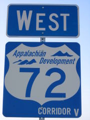
Northeast of downtown Huntsville, US 72 interchanges with Interstate 565. I-565/Alternate 72, part of Corridor V of the Appalachian Development Highway System
, terminates at the interchange while US 72 takes over the freeway alignment, joining Corridor V. Strangely enough, I-65 signs both northbound and southbound do not mention Alt US 72 at the I-565 interchange, only I-565 is mentioned as the eastbound route and only AL 20 is mentioned as the westbound route. Signs for I-565 east at this interchange recently were changed to remove any mention of AL 20 east. Most of the US 72 portion of Corridor V is a four-lane divided expressway
with at-grade intersections. Past Huntsville, US 72 follows several mountain valleys to Scottsboro
. From Scottsboro, the route follows a northeasterly routing similar to that of the Tennessee River as it enters Tennessee
for the second time.
All of US 72 within Alabama is four lanes in width. Additionally, much of US 72 has been upgraded through northeast Alabama, with interchanges at the major state highways. Just west of Moores Mill Road in Huntsville, US 72 becomes limited access over Chapman Mountain.
Throughout Alabama, US 72 is paired with unsigned State Route 2.
. At South Pittsburg, Corridor V ends at an interchange with Interstate 24
. US 64
, concurrent with I-24 west of the exit, departs the expressway and forms an overlap with US 72 through Kimball
to Jasper
, where US 41
joins the concurrency. Just east of Jasper, the highways cross the Tennessee River on Nickajack Lake
. The route then follows a cut in the Cumberland Plateau
made by the Tennessee River to the western outskirts of Chattanooga
, where it interchanges with I-24 once more. Just east of the interchange, US 11
joins the overlap.
Together, US 11, US 41, US 64, and US 72 follow the bluffs on Lookout Mountain
above the Tennessee River
to Chattanooga, where the routes follow Broad Street north into downtown. At the corner of Main Street and Broad Street, US 72 comes to an end; interestingly, US 76
begins at the intersection, making one highway in essence a continuation of the other.
US 72 originally went through downtown South Pittsburg on Cedar Avenue.
and followed a route west to Memphis. In 1931, US 64 replaced US 72 between Memphis and Selmer. In 1935, US 72 was routed to Memphis through Mississippi from Corinth removing the extension on US 45 to Selmer.
As late as the early 1970s, US 72 followed State Route 57
(Poplar Avenue) from Collierville to its western terminus at East Parkway N. (which carried U.S. Route 64
, U.S. Route 70
, and U.S. Route 79
, as well as State Route 1
.)
, US 72 originally followed the current Road 172 / Quitman Street through Iuka before being bypassed in the mid 1980s. Also, An Old US 72 exists south of US 72 between Burnsville and Glen
. US 72 also followed Alcorn County
Road 218 and entered Corinth on Proper Street. Until 1935 US 72 followed US 45, now Polk Street / Mississippi State Route 145 north into Tennessee. Also, included in the original 1935 routing west of Cornith followed Mississippi State Route 2 / Kossuth Road to Kossuth
before turning west. Continuing westward, yet anothert Old US 72 exists south of US 72 in Benton County from just west of the Tippah County
line to just east of the Wolf River
near Canaan. The bridge across the Wolf River is closed. The continuation of this segment west of Wolf River to Mississippi State Route 5 is signed Wyatt Road. Finally, there is one more route that may have been a former US 72 road alignment
. Boswell Road begins as a curve off of US 72 between Slayden
and Mount Pleasant as a gravel road, and heads generally parallel to US 72 as a gravel road, before stopping in Mount Pleasant at Highway 311
. The possible former alignment
then continues from the staggered junction
heading west as a partially paved road. This road is now broken by Highway 302
, but continues to head west as a gravel road
for a mile, for a total of approximately 3.5 miles (5.6 km).
, a critical route for the South during the American Civil War
. Some sections of the original road were named the Memphis Pike reflecting the idea of connecting Chattanooga
to Memphis, Tennessee
. The original route also belonged to the original route of the Lee Highway
. Both of these designations can be found in western Colbert County
where sections of the original highway, including parts of Colbert County Route 20 still bear those names.
The original route once passed through Tuscumbia
on what is named today the Old Lee Highway and Main Street. This route was bypassed in the 1960s.
In Florence
US 72 originally followed Huntsville Road to Royal Avenue, then north to Tennessee Street, and finally west to Court Street. Its route was later moved two blocks south through downtown Florence, from Tennessee Street to Dr. Hicks Blvd.
East of Florence the original route is now County Highway 66 through downtown Rogersville
and Killen
.
Athens'
Clinton and Washington Streets hosted a Business 72 route in earlier years. This route was decommissioned in the 1980s.
US 72 has seen several route changes in Huntsville
that included a temporary route down Sparkman Drive in the 1960s. Other original routes include Andrew Jackson Way to Holmes Avenue and down Holmes Avenue to reconnect to the original route.
Prior to 1931 US 72 passed through Big Cove between Huntsville and Paint Rock
VIA Little Cove Rd/Old "US 431". That route was abandoned for the one used today over Chapman Mountain.
Other original routes include State Route 35 from Woodville
to the west side of Scottsboro
, State Route 279 east of Scottsboro, and State Route 277 from Stevenson
to Bridgeport
. State Route 277
carries the distinction of being the last two lane section of US 72 in Alabama. Today the entire route through Alabama has a minimum of four lanes.
on the south side of the Tennessee River
between Muscle Shoals
and Decatur
. Alternate 72 crosses the Tennessee River
at Decatur
along with U.S. Highway 31 and follows the entire route of Interstate 565
. However signs on I-65 at the I-565 exit make no mention of ALT US 72 and only mention AL 20 westbound from the I-65/I-565 junction. AL 20
was co-signed with Alternate US 72 from Muscle Shoals to Huntsville. AL 20 has since been truncated to the junction of I-65
just east of Decatur. Originally, Alternate US 72 turned off of AL 20 on to AL 53
/ Jordan Lane in Huntsville and followed it north 1 miles (1.6 km) to rejoin with US 72. With the completion of I-565
in the early 1990s, Alt US 72 was routed along with I-565 to the termination of I-565 at US 72.
Alternate U.S. 72 between Decatur
and Huntsville
Alabama is part of Corridor V of the Appalachian Development Highway System
.
Tennessee
Tennessee is a U.S. state located in the Southeastern United States. It has a population of 6,346,105, making it the nation's 17th-largest state by population, and covers , making it the 36th-largest by total land area...
through northern Alabama
Alabama
Alabama is a state located in the southeastern region of the United States. It is bordered by Tennessee to the north, Georgia to the east, Florida and the Gulf of Mexico to the south, and Mississippi to the west. Alabama ranks 30th in total land area and ranks second in the size of its inland...
and northern Mississippi
Mississippi
Mississippi is a U.S. state located in the Southern United States. Jackson is the state capital and largest city. The name of the state derives from the Mississippi River, which flows along its western boundary, whose name comes from the Ojibwe word misi-ziibi...
to southwest Tennessee
Tennessee
Tennessee is a U.S. state located in the Southeastern United States. It has a population of 6,346,105, making it the nation's 17th-largest state by population, and covers , making it the 36th-largest by total land area...
. The highway's eastern terminus is Chattanooga, Tennessee
Chattanooga, Tennessee
Chattanooga is the fourth-largest city in the US state of Tennessee , with a population of 169,887. It is the seat of Hamilton County...
. Its western terminus is Memphis, Tennessee
Memphis, Tennessee
Memphis is a city in the southwestern corner of the U.S. state of Tennessee, and the county seat of Shelby County. The city is located on the 4th Chickasaw Bluff, south of the confluence of the Wolf and Mississippi rivers....
. It is the only US Highway to have both termini in the same state, yet pass through other states in between. Prior to the US Highway system signage being posted in 1925 the entire route was part of the Lee Highway
Lee Highway
The Lee Highway was a National Auto Trail in the United States connecting New York City and San Francisco, California via the South and Southwest. It was named after Robert E...
.
Route description
Tennessee
Tennessee is a U.S. state located in the Southeastern United States. It has a population of 6,346,105, making it the nation's 17th-largest state by population, and covers , making it the 36th-largest by total land area...
, Alabama
Alabama
Alabama is a state located in the southeastern region of the United States. It is bordered by Tennessee to the north, Georgia to the east, Florida and the Gulf of Mexico to the south, and Mississippi to the west. Alabama ranks 30th in total land area and ranks second in the size of its inland...
, and Mississippi
Mississippi
Mississippi is a U.S. state located in the Southern United States. Jackson is the state capital and largest city. The name of the state derives from the Mississippi River, which flows along its western boundary, whose name comes from the Ojibwe word misi-ziibi...
. Most of the original eastern and western portions of the route through roughly follows the path of the Memphis and Charleston Railroad
Memphis and Charleston Railroad
The Memphis and Charleston Railroad, completed in 1857, was the first railroad in the United States to link the Atlantic Ocean with the Mississippi River. Chartered in 1846 the railroad ran from Memphis, Tennessee to Stevenson, Alabama through the towns of Corinth, Mississippi and Huntsville,...
, a railroad that predated the American Civil War
American Civil War
The American Civil War was a civil war fought in the United States of America. In response to the election of Abraham Lincoln as President of the United States, 11 southern slave states declared their secession from the United States and formed the Confederate States of America ; the other 25...
and now operated by Norfolk Southern as their Memphis
Memphis, Tennessee
Memphis is a city in the southwestern corner of the U.S. state of Tennessee, and the county seat of Shelby County. The city is located on the 4th Chickasaw Bluff, south of the confluence of the Wolf and Mississippi rivers....
-Chattanooga mainline. Alternate US 72
U.S. Route 72 Alternate
Alternate US-72 exists in Alabama on the mostly south side of the Tennessee River between Muscle Shoals and Decatur, while US-72 follows on the north side of the river between Florence and Athens. Alternate 72 crosses the Tennessee River at Decatur, Alabama along with U.S. Highway 31 and follows...
follows the Memphis and Charleston route through North Alabama
North Alabama
North Alabama is a region of the U.S. state of Alabama, generally considered to include 12 counties: Cherokee, Colbert, DeKalb, Franklin, Jackson, Lauderdale, Lawrence, Limestone, Madison, Marshall, Morgan, and Winston, with a combined population of 958,247, or 20.84% of the state's population as...
.
Tennessee, first entry
US 72 begins at Bellevue Boulevard (U.S. Route 51) in MemphisMemphis, Tennessee
Memphis is a city in the southwestern corner of the U.S. state of Tennessee, and the county seat of Shelby County. The city is located on the 4th Chickasaw Bluff, south of the confluence of the Wolf and Mississippi rivers....
. From Memphis, the route follows Union Avenue and Poplar Avenue into Collierville
Collierville, Tennessee
Collierville is a town in Shelby County, Tennessee, United States, and a suburb located in the Memphis metropolitan area. The town had a population of 43,965 at the 2010 census....
. Just south of Collierville, US 72 junctions State Route 385
State Route 385 (Tennessee)
State Route 385 is the designation for three separate segments of highway in the Memphis Metropolitan Area in Shelby and Fayette counties in West Tennessee, forming a semicircle around and through the Memphis suburbs. Clockwise, from the north, they are:...
(the Bill Morris Parkway), a freeway which links Collierville with I-240
Interstate 240 (Tennessee)
Interstate 240 is an Interstate Highway in the U.S. state of Tennessee. Running or 31.0 km, it loops southward from Interstate 40 in east Memphis, then turning west at TN 385 . At I-55, the highway turns north and runs through midtown to end at I-40...
. The route enters Mississippi
Mississippi
Mississippi is a U.S. state located in the Southern United States. Jackson is the state capital and largest city. The name of the state derives from the Mississippi River, which flows along its western boundary, whose name comes from the Ojibwe word misi-ziibi...
three miles (5 km) southeast of SR 385. This segment of the highway is concurrently
Concurrency (road)
A concurrency, overlap, or coincidence in a road network is an instance of one physical road bearing two or more different highway, motorway, or other route numbers...
designated Tennessee State Route 86.
Mississippi
US 72 enters Mississippi in western Marshall CountyMarshall County, Mississippi
-Demographics:At the 2000 census, there were 34,993 people, 12,163 households and 9,110 families residing in the county. The population density was 50 per square mile . There were 13,252 housing units at an average density of 19 per square mile...
. The route follows rolling hills across the extreme northern part of the state, passing through Walnut
Walnut, Mississippi
Walnut is a town in Tippah County, Mississippi, United States. The population was 754 at the 2000 census.-Geography:Walnut is located at ....
and Corinth
Corinth, Mississippi
Corinth is a city in Alcorn County, Mississippi, United States. The population was 14,054 at the 2000 census. It is the county seat of Alcorn County. Its ZIP codes are 38834 and 38835.- History :...
as it heads east. Near Burnsville
Burnsville, Mississippi
Burnsville is a town in Tishomingo County, Mississippi, United States. The population was 1,034 at the 2000 census. Its ZIP code is 38833.-Geography:Burnsville is located at ....
, US 72 crosses the Tennessee Tombigbee Waterway. Farther east, the route enters the Tennessee Valley
Tennessee Valley
The Tennessee Valley is the drainage basin of the Tennessee River and is largely within the U.S. state of Tennessee. It stretches from southwest Kentucky to northwest Georgia and from northeast Mississippi to the mountains of Virginia and North Carolina...
and heads through Iuka
Iuka, Mississippi
Iuka is a city in Tishomingo County, Mississippi, United States. The population was 3,059 at the 2000 census. It is the county seat of Tishomingo County. Woodall Mountain, the highest point in Mississippi, is located just south of Iuka.- History :...
before crossing into Alabama
Alabama
Alabama is a state located in the southeastern region of the United States. It is bordered by Tennessee to the north, Georgia to the east, Florida and the Gulf of Mexico to the south, and Mississippi to the west. Alabama ranks 30th in total land area and ranks second in the size of its inland...
.
Most of US 72 in Mississippi has been upgraded to four-lane highway. Legally, the Mississippi section of US 72 is defined in Mississippi Code § 65-3-3.
Alabama
Cherokee, Alabama
Cherokee incorporated December 7 1871 is a town in west Colbert County, Alabama, United States. It is part of the Florence - Muscle Shoals Metropolitan Statistical Area known as "The Shoals". As of the 2000 census, the population of the town is 1,237....
. The route parallels the Tennessee River
Tennessee River
The Tennessee River is the largest tributary of the Ohio River. It is approximately 652 miles long and is located in the southeastern United States in the Tennessee Valley. The river was once popularly known as the Cherokee River, among other names...
east to Muscle Shoals
Muscle Shoals, Alabama
Muscle Shoals is a city in Colbert County, Alabama, United States. As of 2007, the United States Census Bureau estimated the population of the city to be 12,846. The city is included in The Shoals MSA. It is famous for its contributions to American popular music.-Geography:Muscle Shoals is located...
, where Alternate US 72
U.S. Route 72 Alternate
Alternate US-72 exists in Alabama on the mostly south side of the Tennessee River between Muscle Shoals and Decatur, while US-72 follows on the north side of the river between Florence and Athens. Alternate 72 crosses the Tennessee River at Decatur, Alabama along with U.S. Highway 31 and follows...
splits from US 72. US 72 turns north, passing through Muscle Shoals and crossing the Tennessee River, entering Florence
Florence, Alabama
Florence is the county seat of Lauderdale County, Alabama, United States, in the northwestern corner of the state.According to the 2005 Census Bureau estimates, the city's population was 36,721....
on the opposite bank. From Florence to Huntsville
Huntsville, Alabama
Huntsville is a city located primarily in Madison County in the central part of the far northern region of the U.S. state of Alabama. Huntsville is the county seat of Madison County. The city extends west into neighboring Limestone County. Huntsville's population was 180,105 as of the 2010 Census....
, the route heads through areas dominated by farmland. Between the two locales, however, US 72 enters Athens
Athens, Alabama
Athens is a city in Limestone County, Alabama, United States. As of the 2000 census, the population of the city is 18,967. According to the 2009 U.S. Census estimates, the city had a population of 24,234...
.
Northeast of downtown Huntsville, US 72 interchanges with Interstate 565. I-565/Alternate 72, part of Corridor V of the Appalachian Development Highway System
Appalachian Development Highway System
The Appalachian Development Highway System is part of the Appalachian Regional Commission in the United States. See: .-History:...
, terminates at the interchange while US 72 takes over the freeway alignment, joining Corridor V. Strangely enough, I-65 signs both northbound and southbound do not mention Alt US 72 at the I-565 interchange, only I-565 is mentioned as the eastbound route and only AL 20 is mentioned as the westbound route. Signs for I-565 east at this interchange recently were changed to remove any mention of AL 20 east. Most of the US 72 portion of Corridor V is a four-lane divided expressway
Limited-access road
A limited-access road known by various terms worldwide, including limited-access highway, dual-carriageway and expressway, is a highway or arterial road for high-speed traffic which has many or most characteristics of a controlled-access highway , including limited or no access to adjacent...
with at-grade intersections. Past Huntsville, US 72 follows several mountain valleys to Scottsboro
Scottsboro, Alabama
Scottsboro is a city in Jackson County, Alabama, United States. As of the 2010 census, the population of the city is 14,770. Named for its founder Robert Scott, the city is the county seat of Jackson County....
. From Scottsboro, the route follows a northeasterly routing similar to that of the Tennessee River as it enters Tennessee
Tennessee
Tennessee is a U.S. state located in the Southeastern United States. It has a population of 6,346,105, making it the nation's 17th-largest state by population, and covers , making it the 36th-largest by total land area...
for the second time.
All of US 72 within Alabama is four lanes in width. Additionally, much of US 72 has been upgraded through northeast Alabama, with interchanges at the major state highways. Just west of Moores Mill Road in Huntsville, US 72 becomes limited access over Chapman Mountain.
Throughout Alabama, US 72 is paired with unsigned State Route 2.
Tennessee, second entry
US 72 enters Tennessee for the second time just south of South PittsburgSouth Pittsburg, Tennessee
South Pittsburg is a city in Marion County, Tennessee, United States. It is part of the Chattanooga, TN–GA Metropolitan Statistical Area. The population was 3,295 at the 2000 census. South Pittsburg is home to the National Cornbread Festival.-History:...
. At South Pittsburg, Corridor V ends at an interchange with Interstate 24
Interstate 24
Interstate 24 is an Interstate Highway in the Midwestern and Southeastern United States. It runs diagonally from Interstate 57 to Chattanooga, Tennessee, at Interstate 75....
. US 64
U.S. Route 64
U.S. Route 64 is an east–west United States highway that runs for 2,326 miles from eastern North Carolina to just southwest of the Four Corners in northeast Arizona. The western terminus is at U.S. Route 160 in Teec Nos Pos, Arizona. The highway's eastern terminus is at NC 12 and U.S. Route...
, concurrent with I-24 west of the exit, departs the expressway and forms an overlap with US 72 through Kimball
Kimball, Tennessee
Kimball is a town in Marion County, Tennessee, United States. The population was 1,312 at the 2000 census. It is part of the Chattanooga, TN–GA Metropolitan Statistical Area.-Geography:Kimball is located at ....
to Jasper
Jasper, Tennessee
Jasper is a town in Marion County, Tennessee. The population was 3,214 at the 2000 census. It is the county seat of Marion County.Jasper is part of the Chattanooga, TN–GA Metropolitan Statistical Area.-History:...
, where US 41
U.S. Route 41
U.S. Route 41 is a north–south United States Highway that runs from Miami, Florida to the Upper Peninsula of Michigan. Until 1949, the part in southern Florida, from Naples to Miami, was U.S...
joins the concurrency. Just east of Jasper, the highways cross the Tennessee River on Nickajack Lake
Nickajack Lake
Nickajack Lake is the reservoir created by Nickajack Dam as part of the Tennessee Valley Authority. The lake stretches from Nickajack Dam to Chickamauga Dam, and runs along the shores of Chattanooga, TN...
. The route then follows a cut in the Cumberland Plateau
Cumberland Plateau
The Cumberland Plateau is the southern part of the Appalachian Plateau. It includes much of eastern Kentucky and western West Virginia, part of Tennessee, and a small portion of northern Alabama and northwest Georgia . The terms "Allegheny Plateau" and the "Cumberland Plateau" both refer to the...
made by the Tennessee River to the western outskirts of Chattanooga
Chattanooga, Tennessee
Chattanooga is the fourth-largest city in the US state of Tennessee , with a population of 169,887. It is the seat of Hamilton County...
, where it interchanges with I-24 once more. Just east of the interchange, US 11
U.S. Route 11
U.S. Route 11 is a north–south United States highway extending 1,645 miles across the eastern United States. The southern terminus of the route is at U.S. Route 90 in the Bayou Sauvage National Wildlife Refuge in eastern New Orleans, Louisiana. The northern terminus is at the United...
joins the overlap.
Together, US 11, US 41, US 64, and US 72 follow the bluffs on Lookout Mountain
Lookout Mountain
thumb|right|See seven statesLookout Mountain is located at the northwest corner of the U.S. state of Georgia, the northeast corner of Alabama, and along the southern border of Tennessee at Chattanooga. Lookout Mountain, along with Sand Mountain to the northwest, makes up a large portion of the...
above the Tennessee River
Tennessee River
The Tennessee River is the largest tributary of the Ohio River. It is approximately 652 miles long and is located in the southeastern United States in the Tennessee Valley. The river was once popularly known as the Cherokee River, among other names...
to Chattanooga, where the routes follow Broad Street north into downtown. At the corner of Main Street and Broad Street, US 72 comes to an end; interestingly, US 76
U.S. Route 76
U.S. Route 76 is an east–west United States highway that runs for from Chattanooga, Tennessee to Wrightsville Beach, North Carolina.-Tennessee:...
begins at the intersection, making one highway in essence a continuation of the other.
US 72 originally went through downtown South Pittsburg on Cedar Avenue.
Western Tennessee
Originally, US 72 followed US 45 to SelmerSelmer, Tennessee
Selmer is a town in McNairy County, Tennessee, United States, in the southwestern part of the state. The population was 4,541 at the 2000 census. It is the county seat of McNairy County...
and followed a route west to Memphis. In 1931, US 64 replaced US 72 between Memphis and Selmer. In 1935, US 72 was routed to Memphis through Mississippi from Corinth removing the extension on US 45 to Selmer.
As late as the early 1970s, US 72 followed State Route 57
Tennessee State Route 57
Tennessee State Route 57 is an east–west highway that runs from Memphis to the Mississippi state line near Pickwick Dam and Pickwick Landing State Park. Except for in Shelby County, SR 57 is a two lane road generally with a speed limit...
(Poplar Avenue) from Collierville to its western terminus at East Parkway N. (which carried U.S. Route 64
U.S. Route 64
U.S. Route 64 is an east–west United States highway that runs for 2,326 miles from eastern North Carolina to just southwest of the Four Corners in northeast Arizona. The western terminus is at U.S. Route 160 in Teec Nos Pos, Arizona. The highway's eastern terminus is at NC 12 and U.S. Route...
, U.S. Route 70
U.S. Route 70
U.S. Route 70 is an east–west United States highway that runs for 2,385 miles from eastern North Carolina to east-central Arizona. As can be derived from its number, it is a major east–west highway of the Southern and Southwestern United States...
, and U.S. Route 79
U.S. Route 79
U.S. Route 79 is a north–south United States highway. The route is a northeast-southwest diagonal, with both east–west segments and north–south segments equally mixed. The highway's northern terminus is in Russellville, Kentucky, at an intersection with U.S. Highway 68 and KY 80...
, as well as State Route 1
State Route 1 (Tennessee)
State Route 1 , known as the Memphis to Bristol Highway, is a mostly-unsigned state highway in the U.S. state of Tennessee that is 538 miles long. It stretches all the way from Memphis in the southwest corner of the state to Bristol in the northeast corner. Most of the route is overlaid on U.S....
.)
Mississippi
In Tishomingo CountyTishomingo County, Mississippi
As of the census of 2000 there were 19,163 people, 7,917 households, and 5,573 families residing in the county. The population density was 45 people per square mile . There were 9,553 housing units at an average density of 22 per square mile...
, US 72 originally followed the current Road 172 / Quitman Street through Iuka before being bypassed in the mid 1980s. Also, An Old US 72 exists south of US 72 between Burnsville and Glen
Glen, Mississippi
Glen is a town in Alcorn County, Mississippi, United States. The population was 286 at the 2000 census. Its ZIP code is 38846.- History :The town of Glen, located nine miles southeast of Corinth, owes its beginning to the Memphis & Charleston Railroad...
. US 72 also followed Alcorn County
Alcorn County, Mississippi
There were 14,224 households out of which 30.90% had children under the age of 18 living with them, 54.50% were married couples living together, 11.50% had a female householder with no husband present, and 30.30% were non-families. 27.60% of all households were made up of individuals and 11.90% had...
Road 218 and entered Corinth on Proper Street. Until 1935 US 72 followed US 45, now Polk Street / Mississippi State Route 145 north into Tennessee. Also, included in the original 1935 routing west of Cornith followed Mississippi State Route 2 / Kossuth Road to Kossuth
Kossuth, Mississippi
Kossuth is a village in Alcorn County, Mississippi, United States. The population was 170 at the 2000 census. Its zip code is 38834.-History:...
before turning west. Continuing westward, yet anothert Old US 72 exists south of US 72 in Benton County from just west of the Tippah County
Tippah County, Mississippi
-Demographics:At the 2000 census, there are 20,826 people, 8,108 households and 5,910 families residing in the county. The population density was 46 per square mile . There were 8,868 housing units at an average density of 19 per square mile...
line to just east of the Wolf River
Wolf River (Tennessee)
The Wolf River is a alluvial stream in western Tennessee and northern Mississippi, whose confluence with the Mississippi River was the site of various Chickasaw, French, Spanish and American communities and forts that eventually became Memphis, Tennessee....
near Canaan. The bridge across the Wolf River is closed. The continuation of this segment west of Wolf River to Mississippi State Route 5 is signed Wyatt Road. Finally, there is one more route that may have been a former US 72 road alignment
Alignment
Alignment may refer to:* Alignment , secondary evidence used to associate features such as postholes* Alignment , in Israel from 1965 to 1992...
. Boswell Road begins as a curve off of US 72 between Slayden
Slayden, Mississippi
Slayden is an unincorporated community located in Marshall County, Mississippi, United States. It is located along U. S. Route 72 on the Northeast side of Marshall County. Although Slayden is unincorporated, it shares a ZIP code of 38642 with Lamar, Mississippi.....
and Mount Pleasant as a gravel road, and heads generally parallel to US 72 as a gravel road, before stopping in Mount Pleasant at Highway 311
Mississippi Highway 311
Mississippi Highway 311 is a state highway located in Marshall County, Mississippi. The route runs from MS 7 in Holly Springs north to U.S. Route 72 in Mt. Pleasant. The route is a two-lane undivided road its entire length and passes through rural areas of woods and farms. MS 311 was designated...
. The possible former alignment
Alignment
Alignment may refer to:* Alignment , secondary evidence used to associate features such as postholes* Alignment , in Israel from 1965 to 1992...
then continues from the staggered junction
Staggered junction
A staggered junction is a place where several roads meet a main road at a slight distance apart thus they do not all come together at the same point....
heading west as a partially paved road. This road is now broken by Highway 302
Mississippi Highway 302
Mississippi Highway 302 is the main east-west highway in DeSoto County, Mississippi, extending into Marshall County, Mississippi to the east. It runs approximately two miles south of the Mississippi/Tennessee state line, from a western terminus at Mississippi Highway 161 in Walls, to U.S...
, but continues to head west as a gravel road
Gravel road
A gravel road is a type of unpaved road surfaced with gravel that has been brought to the site from a quarry or stream bed. They are common in less-developed nations, and also in the rural areas of developed nations such as Canada and the United States. In New Zealand, they are known as 'metal roads'...
for a mile, for a total of approximately 3.5 miles (5.6 km).
Alabama
Most of the original US 72 route in Alabama paralleled the Memphis and Charleston RailroadMemphis and Charleston Railroad
The Memphis and Charleston Railroad, completed in 1857, was the first railroad in the United States to link the Atlantic Ocean with the Mississippi River. Chartered in 1846 the railroad ran from Memphis, Tennessee to Stevenson, Alabama through the towns of Corinth, Mississippi and Huntsville,...
, a critical route for the South during the American Civil War
American Civil War
The American Civil War was a civil war fought in the United States of America. In response to the election of Abraham Lincoln as President of the United States, 11 southern slave states declared their secession from the United States and formed the Confederate States of America ; the other 25...
. Some sections of the original road were named the Memphis Pike reflecting the idea of connecting Chattanooga
Chattanooga, Tennessee
Chattanooga is the fourth-largest city in the US state of Tennessee , with a population of 169,887. It is the seat of Hamilton County...
to Memphis, Tennessee
Memphis, Tennessee
Memphis is a city in the southwestern corner of the U.S. state of Tennessee, and the county seat of Shelby County. The city is located on the 4th Chickasaw Bluff, south of the confluence of the Wolf and Mississippi rivers....
. The original route also belonged to the original route of the Lee Highway
Lee Highway
The Lee Highway was a National Auto Trail in the United States connecting New York City and San Francisco, California via the South and Southwest. It was named after Robert E...
. Both of these designations can be found in western Colbert County
Colbert County, Alabama
Colbert County is a county of the U.S. state of Alabama. Its name is in honor of brothers George and Levi Colbert, Chickasaw Indian chiefs. George Colbert operated a ferry across the Tennessee River in 1790 near present day Cherokee....
where sections of the original highway, including parts of Colbert County Route 20 still bear those names.
The original route once passed through Tuscumbia
Tuscumbia, Alabama
Tuscumbia is a city in and the county seat of Colbert County, Alabama, United States. As of the 2010 census, the population was 8,423 and is included in The Shoals MSA....
on what is named today the Old Lee Highway and Main Street. This route was bypassed in the 1960s.
In Florence
Florence, Alabama
Florence is the county seat of Lauderdale County, Alabama, United States, in the northwestern corner of the state.According to the 2005 Census Bureau estimates, the city's population was 36,721....
US 72 originally followed Huntsville Road to Royal Avenue, then north to Tennessee Street, and finally west to Court Street. Its route was later moved two blocks south through downtown Florence, from Tennessee Street to Dr. Hicks Blvd.
East of Florence the original route is now County Highway 66 through downtown Rogersville
Rogersville, Alabama
Rogersville is a town in Lauderdale County, Alabama, United States. It is part of the Florence - Muscle Shoals Metropolitan Statistical Area known as "The Shoals". As of the 2000 census, the population of the town is 1,199.-History:...
and Killen
Killen, Alabama
Killen is a town in Lauderdale County, Alabama, United States. It is part of the Florence - Muscle Shoals Metropolitan Statistical Area known as "The Shoals". As of the 2000 census, the population of the town is 1,190.-Geography:...
.
Athens'
Athens, Alabama
Athens is a city in Limestone County, Alabama, United States. As of the 2000 census, the population of the city is 18,967. According to the 2009 U.S. Census estimates, the city had a population of 24,234...
Clinton and Washington Streets hosted a Business 72 route in earlier years. This route was decommissioned in the 1980s.
US 72 has seen several route changes in Huntsville
Huntsville, Alabama
Huntsville is a city located primarily in Madison County in the central part of the far northern region of the U.S. state of Alabama. Huntsville is the county seat of Madison County. The city extends west into neighboring Limestone County. Huntsville's population was 180,105 as of the 2010 Census....
that included a temporary route down Sparkman Drive in the 1960s. Other original routes include Andrew Jackson Way to Holmes Avenue and down Holmes Avenue to reconnect to the original route.
Prior to 1931 US 72 passed through Big Cove between Huntsville and Paint Rock
Paint Rock, Alabama
Paint Rock is a town in Jackson County, Alabama, United States, along the Paint Rock River, and is included in the Huntsville-Decatur Combined Statistical Area. As of the 2000 census, the population of the town is 185....
VIA Little Cove Rd/Old "US 431". That route was abandoned for the one used today over Chapman Mountain.
Other original routes include State Route 35 from Woodville
Woodville, Alabama
Woodville is a town in Jackson County, Alabama, United States, and is included in the Huntsville-Decatur Combined Statistical Area. As of the 2000 census, the population of the town is 761.-History:...
to the west side of Scottsboro
Scottsboro, Alabama
Scottsboro is a city in Jackson County, Alabama, United States. As of the 2010 census, the population of the city is 14,770. Named for its founder Robert Scott, the city is the county seat of Jackson County....
, State Route 279 east of Scottsboro, and State Route 277 from Stevenson
Stevenson, Alabama
Stevenson is a city in Jackson County, Alabama, United States, and is included in the Huntsville-Decatur Combined Statistical Area. As of the 2000 census, the population of the city is 1,770.-Geography:Stevenson is located at ....
to Bridgeport
Bridgeport, Alabama
Bridgeport is a small city in Jackson County, Alabama, United States. At the time of 2000 census the population was 2,728. Bridgeport is included in the Huntsville-Decatur Combined Statistical Area.-History:...
. State Route 277
State Route 277 (Alabama)
State Route 277 is a state highway in the U.S. state of Alabama, running along part of former U.S. Highway 72 in Jackson County. Upon completion of the present US-72 expressway in the 1990s, the old road was given to the county and cities of Stevenson and Bridgeport to maintain as County Road 74,...
carries the distinction of being the last two lane section of US 72 in Alabama. Today the entire route through Alabama has a minimum of four lanes.
Alternate routes
An Alternate US 72 exists in AlabamaAlabama
Alabama is a state located in the southeastern region of the United States. It is bordered by Tennessee to the north, Georgia to the east, Florida and the Gulf of Mexico to the south, and Mississippi to the west. Alabama ranks 30th in total land area and ranks second in the size of its inland...
on the south side of the Tennessee River
Tennessee River
The Tennessee River is the largest tributary of the Ohio River. It is approximately 652 miles long and is located in the southeastern United States in the Tennessee Valley. The river was once popularly known as the Cherokee River, among other names...
between Muscle Shoals
Muscle Shoals, Alabama
Muscle Shoals is a city in Colbert County, Alabama, United States. As of 2007, the United States Census Bureau estimated the population of the city to be 12,846. The city is included in The Shoals MSA. It is famous for its contributions to American popular music.-Geography:Muscle Shoals is located...
and Decatur
Decatur, Alabama
Decatur is a city in Limestone and Morgan Counties in the U.S. state of Alabama. The city, affectionately known as "The River City", is located in Northern Alabama on the banks of Wheeler Lake, along the Tennessee River. It is the largest city and county seat of Morgan County...
. Alternate 72 crosses the Tennessee River
Tennessee River
The Tennessee River is the largest tributary of the Ohio River. It is approximately 652 miles long and is located in the southeastern United States in the Tennessee Valley. The river was once popularly known as the Cherokee River, among other names...
at Decatur
Decatur, Alabama
Decatur is a city in Limestone and Morgan Counties in the U.S. state of Alabama. The city, affectionately known as "The River City", is located in Northern Alabama on the banks of Wheeler Lake, along the Tennessee River. It is the largest city and county seat of Morgan County...
along with U.S. Highway 31 and follows the entire route of Interstate 565
Interstate 565
-External links:***...
. However signs on I-65 at the I-565 exit make no mention of ALT US 72 and only mention AL 20 westbound from the I-65/I-565 junction. AL 20
State Route 20 (Alabama)
State Route 20 ' runs from the Tennessee state line northwest of Florence, Alabama, east to I-65 east of Decatur in the northwestern Alabama...
was co-signed with Alternate US 72 from Muscle Shoals to Huntsville. AL 20 has since been truncated to the junction of I-65
Interstate 65
Interstate 65 is a major Interstate Highway in the United States. The southern terminus is located at an intersection with Interstate 10 in Mobile, Alabama, and its northern terminus is at an interchange with Interstate 90 , U.S. Route 12, and U.S...
just east of Decatur. Originally, Alternate US 72 turned off of AL 20 on to AL 53
State Route 53 (Alabama)
State Route 53 is a state highway in the U.S. state of Alabama. The majority, between Dothan and Huntsville, is signed as U.S. Highway 231 , but the two ends - south to Florida and north to I-65/US-31 near Tennessee - are independent...
/ Jordan Lane in Huntsville and followed it north 1 miles (1.6 km) to rejoin with US 72. With the completion of I-565
Interstate 565
-External links:***...
in the early 1990s, Alt US 72 was routed along with I-565 to the termination of I-565 at US 72.
Alternate U.S. 72 between Decatur
Decatur, Alabama
Decatur is a city in Limestone and Morgan Counties in the U.S. state of Alabama. The city, affectionately known as "The River City", is located in Northern Alabama on the banks of Wheeler Lake, along the Tennessee River. It is the largest city and county seat of Morgan County...
and Huntsville
Huntsville, Alabama
Huntsville is a city located primarily in Madison County in the central part of the far northern region of the U.S. state of Alabama. Huntsville is the county seat of Madison County. The city extends west into neighboring Limestone County. Huntsville's population was 180,105 as of the 2010 Census....
Alabama is part of Corridor V of the Appalachian Development Highway System
Appalachian Development Highway System
The Appalachian Development Highway System is part of the Appalachian Regional Commission in the United States. See: .-History:...
.