
Interstate 40 in California
Encyclopedia
In the U.S. state
of California
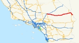
, Interstate 40 (I-40) has its western terminus in Barstow
. Known as the Needles Freeway, a major east–west route of the Interstate Highway System
, it heads east from Barstow across the Mojave Desert
in San Bernardino County
past the Clipper Mountains
to Needles
, before it crosses into Arizona
west of Kingman
.
and is eligible for the State Scenic Highway System
. However, it is not a scenic highway as designated by Caltrans. Interstate 40 from Interstate 15 to the Arizona State Line is known as the Needles Freeway, as named by Senate Concurrent Resolution 1 in 1968. Interstate 40 goes through the Mojave Desert
on its entire journey through California.
I-40 starts out at a junction with Interstate 15
in Barstow
. The freeway passes through Marine Corps Logistics Base Barstow
before leaving the city limits. I-40 provides access to the town of Daggett
but passes south of the town. After passing south of the Barstow-Daggett Airport, I-40 goes through Newberry Springs
and Ludlow
before traveling along the south end of Mojave National Preserve
. Several miles east of the preserve, I-40 intersects US 95 and the two highways run concurrently into the city of Needles
. In Needles, US 95 continues south while I-40 continues east through Mojave Regional Park and across the Colorado River
into Arizona
.
The maximum speed limit for the entire California segment of Interstate 40 is 70 mi/h.
Today, the Needles Freeway replaced what used to be Route 66 across the Mojave Desert. As a result, a number of communities along the former route like Amboy
have become ghost town
s.
A sign in California showing the distance to Wilmington, North Carolina
has been stolen several times.
between Barstow and Bakersfield
for chargeable Interstate approval twice, in 1956 and 1968, presumably as an extension of Interstate 40, but it was rejected both times. As a result of these rejections, this segment of SR 58 is being upgraded to freeway standards piece-by-piece as Caltrans
has funds available. However, there is no current push to apply for Interstate designation.
. It provides access to downtown Needles as Broadway Street. It also follows the former routing of U.S. Route 66.
The entire route is in San Bernardino County
.
{| class=wikitable
|-
!Location
!Postmile
!Exit
!Destinations
!Notes
|-
|rowspan=2|Barstow
| style="background:#fdd;"|R0.00
| style="background:#fdd;"|
| style="background:#fdd;"|
| style="background:#fdd;"|Westbound exit and eastbound entrance
|-
|R0.79
|1
|Montara Road, East Main Street (I-15 Bus. south, to I-15 north)
|East Main Street was former US 66
west
|-
|
|R2.35
|2
|Marine Corps Logistics Base Barstow
|Former US 66
east
|-
|
| style="background:#fdd;"|R4.71
| style="background:#fdd;"|5
| style="background:#fdd;"|Nebo Street
| style="background:#fdd;"|Eastbound exit and westbound entrance
|-
|Daggett
|R7.18
|7
|A Street – Daggett
|
|-
|
|R12.19
|12
|Airport Road – Barstow-Daggett Airport
|
|-
|Newberry Springs
|R18.45
|18
|National Trails Highway – Newberry Springs
|Former US 66
|-
|
|R23.33
|23
|Fort Cady Road – Newberry Springs
|
|-
|
|R32.50
|33
|Hector Road
|
|-
|Ludlow
|R49.98
|50
|Crucero Road – Ludlow
|Former US 66
|-
|
|R78.17
|78
|Kelbaker Road
|
|-
|
|R99.73
|100
|Essex Road – Essex
|
|-
|
|R107.17
|107
|Goffs Road – Essex
|
|-
|
|R115.19
|115
|Mountain Springs Road
|Former US 66
|-
|
|R119.97
|120
|Water Road
|
|-
|
| style="background:#dfd;"|R132.73
| style="background:#dfd;"|133
| style="background:#dfd;"| – Searchlight
, Las Vegas
| style="background:#dfd;"|West end of US 95 overlap; former US 66
west
|-
|rowspan=4|Needles
| style="background:#fdd;"|R139.11
| style="background:#fdd;"|139
| style="background:#fdd;"|River Road Cutoff
| style="background:#fdd;"|Eastbound exit and westbound entrance
|-
|R141.01
|141
|West Broadway, River Road (I-40 Bus. east)
|West Broadway was former US 66
east
|-
|R142.37
|142
|J Street – Downtown Needles
|
|- style="background:#dfd;"
|R143.76
|144
|
|East end of US 95 overlap; former US 66
|-
|
|R148.19
|148
|.svg.png) Five Mile Road to US 95
Five Mile Road to US 95
south – Blythe
|Former US 66
west
|-
|
|R153.31
|153
|Park Moabi Road
|
|-
|
|R154.64
| colspan="3" style="text-align:center;"|Arizona state line
U.S. state
A U.S. state is any one of the 50 federated states of the United States of America that share sovereignty with the federal government. Because of this shared sovereignty, an American is a citizen both of the federal entity and of his or her state of domicile. Four states use the official title of...
of California
California
California is a state located on the West Coast of the United States. It is by far the most populous U.S. state, and the third-largest by land area...
, Interstate 40 (I-40) has its western terminus in Barstow
Barstow, California
Barstow is a city in San Bernardino County, California, United States. The population was 22,639 at the 2010 census, up from 21,119 at the 2000 census. Barstow is located north of San Bernardino....
. Known as the Needles Freeway, a major east–west route of the Interstate Highway System
Interstate Highway System
The Dwight D. Eisenhower National System of Interstate and Defense Highways, , is a network of limited-access roads including freeways, highways, and expressways forming part of the National Highway System of the United States of America...
, it heads east from Barstow across the Mojave Desert
Mojave Desert
The Mojave Desert occupies a significant portion of southeastern California and smaller parts of central California, southern Nevada, southwestern Utah and northwestern Arizona, in the United States...
in San Bernardino County
San Bernardino County, California
San Bernardino County is a county in the U.S. state of California. As of the 2010 census, the population was 2,035,210, up from 1,709,434 as of the 2000 census...
past the Clipper Mountains
Clipper Mountains
The Clipper Mountains are located in the Mojave Desert of eastern San Bernardino County, California. The range parallels the central-southern border of the large Mojave National Preserve and is found just south of Interstate 40 and the Clipper Valley, between the freeway and the National Old Trails...
to Needles
Needles, California
Needles is a city located in the Mojave Desert on the western banks of the Colorado River in San Bernardino County, California. It is located in the Mohave Valley, which straddles the California–Arizona border. The city is accessible via Interstate 40 and U.S. Route 95...
, before it crosses into Arizona
Arizona
Arizona ; is a state located in the southwestern region of the United States. It is also part of the western United States and the mountain west. The capital and largest city is Phoenix...
west of Kingman
Kingman, Arizona
Kingman is located in a desert climate on the edge of the Mojave Desert, but its higher elevation and location between the Colorado Plateau and the Lower Colorado River Valley tempers summer high temperatures and contributes to winter cold and rare snowfall. Summer daytime highs reach above 90 °F ...
.
Route description
This route is part of the California Freeway and Expressway SystemCalifornia Freeway and Expressway System
The California Freeway and Expressway System is a system of existing or planned freeways and expressways in the U.S. state of California. It is defined by the Streets and Highways Code.-List of roads in the system:*State Route 1 *State Route 2...
and is eligible for the State Scenic Highway System
State Scenic Highway System (California)
The State Scenic Highway System is a list of highways, mainly state highways, that have been designated by the California Department of Transportation as scenic highways. The California State Legislature, primarily through Section 263 of the Streets and Highways Code, makes highways eligible for...
. However, it is not a scenic highway as designated by Caltrans. Interstate 40 from Interstate 15 to the Arizona State Line is known as the Needles Freeway, as named by Senate Concurrent Resolution 1 in 1968. Interstate 40 goes through the Mojave Desert
Mojave Desert
The Mojave Desert occupies a significant portion of southeastern California and smaller parts of central California, southern Nevada, southwestern Utah and northwestern Arizona, in the United States...
on its entire journey through California.
I-40 starts out at a junction with Interstate 15
Interstate 15 in California
In the U.S. state of California, Interstate 15 is a major north–south route through the San Bernardino, Riverside, and San Diego Counties, and it has a length of in the state. It is a major thoroughfare for traffic between Southern California and Las Vegas, Nevada, as well as points beyond...
in Barstow
Barstow, California
Barstow is a city in San Bernardino County, California, United States. The population was 22,639 at the 2010 census, up from 21,119 at the 2000 census. Barstow is located north of San Bernardino....
. The freeway passes through Marine Corps Logistics Base Barstow
Marine Corps Logistics Base Barstow
Marine Corps Logistics Base Barstow is a United States Marine Corps supply and maintenance installation located east of Barstow, California. Its mission is to rebuild and repair ground-combat and combat-support equipment and to support installations on the West Coast of the United States...
before leaving the city limits. I-40 provides access to the town of Daggett
Daggett, California
Daggett is an unincorporated town located in San Bernardino County, California in the United States. The town is located on Interstate 40 ten miles East of Barstow. The town has a population of about 200. The ZIP code is 92327 and the community is inside area code 760.-History:The town was...
but passes south of the town. After passing south of the Barstow-Daggett Airport, I-40 goes through Newberry Springs
Newberry Springs, California
Newberry Springs is an unincorporated area in the western Mojave Desert of Southern California, located at the foot of the Newberry Mountains in San Bernardino County, California, USA...
and Ludlow
Ludlow, California
Ludlow is a small town in the Mojave Desert on Interstate 40, located in San Bernardino County, California, United States. The older remains of the ghost town are along historic Route 66.-Geography:...
before traveling along the south end of Mojave National Preserve
Mojave National Preserve
Mojave National Preserve is located in the Mojave Desert of San Bernardino County, California, USA, between Interstate 15 and Interstate 40. The preserve was established October 31, 1994 with the passage of the California Desert Protection Act by the US Congress...
. Several miles east of the preserve, I-40 intersects US 95 and the two highways run concurrently into the city of Needles
Needles, California
Needles is a city located in the Mojave Desert on the western banks of the Colorado River in San Bernardino County, California. It is located in the Mohave Valley, which straddles the California–Arizona border. The city is accessible via Interstate 40 and U.S. Route 95...
. In Needles, US 95 continues south while I-40 continues east through Mojave Regional Park and across the Colorado River
Colorado River
The Colorado River , is a river in the Southwestern United States and northwestern Mexico, approximately long, draining a part of the arid regions on the western slope of the Rocky Mountains. The watershed of the Colorado River covers in parts of seven U.S. states and two Mexican states...
into Arizona
Arizona
Arizona ; is a state located in the southwestern region of the United States. It is also part of the western United States and the mountain west. The capital and largest city is Phoenix...
.
The maximum speed limit for the entire California segment of Interstate 40 is 70 mi/h.
History
The segment of I-40 in California was approved as a chargeable Interstate on July 7, 1947. In 1957, the California Department of Highways proposed that the route be renumbered to Interstate 30 instead because of the already existing U.S. Route 40 in the state. However, this was rejected, and eventually U.S. 40 was decommissioned in favor of Interstate 80.Today, the Needles Freeway replaced what used to be Route 66 across the Mojave Desert. As a result, a number of communities along the former route like Amboy
Amboy, California
Amboy is an unincorporated town in San Bernardino County, in California's Mojave Desert, west of Needles and east of Ludlow on historic Route 66. It is roughly 60 miles northeast of Twentynine Palms.-Geography:...
have become ghost town
Ghost town
A ghost town is an abandoned town or city. A town often becomes a ghost town because the economic activity that supported it has failed, or due to natural or human-caused disasters such as floods, government actions, uncontrolled lawlessness, war, or nuclear disasters...
s.
A sign in California showing the distance to Wilmington, North Carolina
Wilmington, North Carolina
Wilmington is a port city in and is the county seat of New Hanover County, North Carolina, United States. The population is 106,476 according to the 2010 Census, making it the eighth most populous city in the state of North Carolina...
has been stolen several times.
Future
The State of California submitted the segment of what is now State Route 58California State Route 58
State Route 58 is an east-west highway across the California Coast Ranges, the southern San Joaquin Valley, the Tehachapi Mountains, which border the southern Sierra Nevada, and the Mojave Desert. It runs between its western terminus near Santa Margarita and its eastern terminus at Barstow...
between Barstow and Bakersfield
Bakersfield, California
Bakersfield is a city near the southern end of the San Joaquin Valley in Kern County, California. It is roughly equidistant between Fresno and Los Angeles, to the north and south respectively....
for chargeable Interstate approval twice, in 1956 and 1968, presumably as an extension of Interstate 40, but it was rejected both times. As a result of these rejections, this segment of SR 58 is being upgraded to freeway standards piece-by-piece as Caltrans
California Department of Transportation
The California Department of Transportation is a government department in the U.S. state of California. Its mission is to improve mobility across the state. It manages the state highway system and is actively involved with public transportation systems throughout the state...
has funds available. However, there is no current push to apply for Interstate designation.
Needles business loop
Interstate 40 Business is a Business loop in Needles, CaliforniaNeedles, California
Needles is a city located in the Mojave Desert on the western banks of the Colorado River in San Bernardino County, California. It is located in the Mohave Valley, which straddles the California–Arizona border. The city is accessible via Interstate 40 and U.S. Route 95...
. It provides access to downtown Needles as Broadway Street. It also follows the former routing of U.S. Route 66.
Exit list
- Note: Except where prefixed with a letter, postmiles were measured in 1964, based on the alignment as it existed at that time, and do not necessarily reflect current mileage.
The entire route is in San Bernardino County
San Bernardino County, California
San Bernardino County is a county in the U.S. state of California. As of the 2010 census, the population was 2,035,210, up from 1,709,434 as of the 2000 census...
.
{| class=wikitable
|-
!Location
!Postmile
!Exit
Exit number
An exit number is a number assigned to a road junction, usually an exit from a freeway. It is usually marked on the same sign as the destinations of the exit, as well as a sign in the gore....
!Destinations
!Notes
|-
|rowspan=2|Barstow
Barstow, California
Barstow is a city in San Bernardino County, California, United States. The population was 22,639 at the 2010 census, up from 21,119 at the 2000 census. Barstow is located north of San Bernardino....
| style="background:#fdd;"|R0.00
| style="background:#fdd;"|
| style="background:#fdd;"|
| style="background:#fdd;"|Westbound exit and eastbound entrance
|-
|R0.79
|1
|Montara Road, East Main Street (I-15 Bus. south, to I-15 north)
|East Main Street was former US 66
U.S. Route 66 in California
In the U.S. state of California, U.S. Route 66 is a former U.S. highway. All the portions were deleted by 1964 during the 1964 renumbering.-History:U.S...
west
|-
|
|R2.35
|2
|Marine Corps Logistics Base Barstow
Marine Corps Logistics Base Barstow
Marine Corps Logistics Base Barstow is a United States Marine Corps supply and maintenance installation located east of Barstow, California. Its mission is to rebuild and repair ground-combat and combat-support equipment and to support installations on the West Coast of the United States...
|Former US 66
U.S. Route 66 in California
In the U.S. state of California, U.S. Route 66 is a former U.S. highway. All the portions were deleted by 1964 during the 1964 renumbering.-History:U.S...
east
|-
|
| style="background:#fdd;"|R4.71
| style="background:#fdd;"|5
| style="background:#fdd;"|Nebo Street
| style="background:#fdd;"|Eastbound exit and westbound entrance
|-
|Daggett
Daggett, California
Daggett is an unincorporated town located in San Bernardino County, California in the United States. The town is located on Interstate 40 ten miles East of Barstow. The town has a population of about 200. The ZIP code is 92327 and the community is inside area code 760.-History:The town was...
|R7.18
|7
|A Street – Daggett
Daggett, California
Daggett is an unincorporated town located in San Bernardino County, California in the United States. The town is located on Interstate 40 ten miles East of Barstow. The town has a population of about 200. The ZIP code is 92327 and the community is inside area code 760.-History:The town was...
|
|-
|
|R12.19
|12
|Airport Road – Barstow-Daggett Airport
Barstow-Daggett Airport
Barstow-Daggett Airport is a county-owned public-use airport in San Bernardino County, California, United States. It is located four nautical miles east of the central business district of the town of Daggett, and east of the city of Barstow...
|
|-
|Newberry Springs
Newberry Springs, California
Newberry Springs is an unincorporated area in the western Mojave Desert of Southern California, located at the foot of the Newberry Mountains in San Bernardino County, California, USA...
|R18.45
|18
|National Trails Highway – Newberry Springs
Newberry Springs, California
Newberry Springs is an unincorporated area in the western Mojave Desert of Southern California, located at the foot of the Newberry Mountains in San Bernardino County, California, USA...
|Former US 66
U.S. Route 66 in California
In the U.S. state of California, U.S. Route 66 is a former U.S. highway. All the portions were deleted by 1964 during the 1964 renumbering.-History:U.S...
|-
|
|R23.33
|23
|Fort Cady Road – Newberry Springs
Newberry Springs, California
Newberry Springs is an unincorporated area in the western Mojave Desert of Southern California, located at the foot of the Newberry Mountains in San Bernardino County, California, USA...
|
|-
|
|R32.50
|33
|Hector Road
|
|-
|Ludlow
Ludlow, California
Ludlow is a small town in the Mojave Desert on Interstate 40, located in San Bernardino County, California, United States. The older remains of the ghost town are along historic Route 66.-Geography:...
|R49.98
|50
|Crucero Road – Ludlow
Ludlow, California
Ludlow is a small town in the Mojave Desert on Interstate 40, located in San Bernardino County, California, United States. The older remains of the ghost town are along historic Route 66.-Geography:...
|Former US 66
U.S. Route 66 in California
In the U.S. state of California, U.S. Route 66 is a former U.S. highway. All the portions were deleted by 1964 during the 1964 renumbering.-History:U.S...
|-
|
|R78.17
|78
|Kelbaker Road
|
|-
|
|R99.73
|100
|Essex Road – Essex
|
|-
|
|R107.17
|107
|Goffs Road – Essex
|
|-
|
|R115.19
|115
|Mountain Springs Road
|Former US 66
U.S. Route 66 in California
In the U.S. state of California, U.S. Route 66 is a former U.S. highway. All the portions were deleted by 1964 during the 1964 renumbering.-History:U.S...
|-
|
|R119.97
|120
|Water Road
|
|-
|
| style="background:#dfd;"|R132.73
| style="background:#dfd;"|133
| style="background:#dfd;"| – Searchlight
Searchlight, Nevada
Searchlight is an unincorporated town in Clark County, Nevada, at the topographic saddle between two mountain ranges.-History:According to Nevada Senator Harry Reid, who has written extensively about his hometown, the most likely story as to how the town received its name was when George Frederick...
, Las Vegas
Las Vegas, Nevada
Las Vegas is the most populous city in the U.S. state of Nevada and is also the county seat of Clark County, Nevada. Las Vegas is an internationally renowned major resort city for gambling, shopping, and fine dining. The city bills itself as The Entertainment Capital of the World, and is famous...
| style="background:#dfd;"|West end of US 95 overlap; former US 66
U.S. Route 66 in California
In the U.S. state of California, U.S. Route 66 is a former U.S. highway. All the portions were deleted by 1964 during the 1964 renumbering.-History:U.S...
west
|-
|rowspan=4|Needles
Needles, California
Needles is a city located in the Mojave Desert on the western banks of the Colorado River in San Bernardino County, California. It is located in the Mohave Valley, which straddles the California–Arizona border. The city is accessible via Interstate 40 and U.S. Route 95...
| style="background:#fdd;"|R139.11
| style="background:#fdd;"|139
| style="background:#fdd;"|River Road Cutoff
| style="background:#fdd;"|Eastbound exit and westbound entrance
|-
|R141.01
|141
|West Broadway, River Road (I-40 Bus. east)
|West Broadway was former US 66
U.S. Route 66 in California
In the U.S. state of California, U.S. Route 66 is a former U.S. highway. All the portions were deleted by 1964 during the 1964 renumbering.-History:U.S...
east
|-
|R142.37
|142
|J Street – Downtown Needles
|
|- style="background:#dfd;"
|R143.76
|144
|
|East end of US 95 overlap; former US 66
U.S. Route 66 in California
In the U.S. state of California, U.S. Route 66 is a former U.S. highway. All the portions were deleted by 1964 during the 1964 renumbering.-History:U.S...
|-
|
|R148.19
|148
|
U.S. Route 95 in California
In the U.S. state of California, U.S. Route 95 traverses through the far eastern edges of both Riverside and San Bernardino counties. US 95 serves Blythe and Needles and junctions with SR 62 at Vidal Junction....
south – Blythe
Blythe, California
Blythe is a city in Riverside County, California, United States, in the "Palo Verde Valley" of the Lower Colorado River Valley region, an agricultural area and part of the Colorado Desert along the Colorado River. Blythe was named after Thomas Blythe, a gold prospector who established primary...
|Former US 66
U.S. Route 66 in California
In the U.S. state of California, U.S. Route 66 is a former U.S. highway. All the portions were deleted by 1964 during the 1964 renumbering.-History:U.S...
west
|-
|
|R153.31
|153
|Park Moabi Road
|
|-
|
|R154.64
| colspan="3" style="text-align:center;"|Arizona state line