
Interstate H-3
Encyclopedia
Interstate H-3 is an intrastate Interstate Highway located on the island of O'ahu in the state of Hawai'i in the United States
. H-3 is also known as the John A. Burns
Freeway. It crosses the Ko'olau Range along a viaduct and through the 5165 feet (1.6 km) long Tetsuo Harano Tunnels
as well as the much smaller Hospital Rock Tunnels
.
Despite the number, signage is that of an east–west highway. Its western terminus is at an intersection of Interstate H-1
at Hālawa near Pearl Harbor
. Its eastern end is at the main gate of Marine Corps Base Hawaii
(MCBH). This route satisfies the national defense purpose of connecting the Marine Corps base with the U.S. Navy port at Pearl Harbor off Interstate H-1.
Orders for the freeway were granted in 1960, followed by planning stages. Construction, amid enormous community protest, was begun in the late 1980s, although the road did not open until December 12, 1997. Environmental complaints and legal challenges halted construction at many points. Construction resumed during the late 1980s due to an unprecedented move by U.S. Senator
Daniel Inouye
, who in 1986 had the freeway exempted from most environmental law
s as a rider
on a Department of Defense
budget bill
.
H-3 is one of the most expensive Interstate Highways ever built, on a cost per mile basis. Its final cost was $1.3 billion, or approximately $80 million per mile.
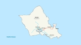
 Interstate H-3 begins at the Hālawa Interchange with Interstates H-1
and H-201
. The freeway then runs along a viaduct through Hālawa Valley for about 6 miles (9.7 km) until it reaches the Tetsuo Harano Tunnels
through the Ko'olau Mountains. Once on the eastern end of the tunnel, the freeway follows a viaduct built along the side of Haiku Valley until the Kaneohe Interchange with State Route 63 (Likelike Highway) which leads into the town of Kaneohe. The freeway then continues to the Halekou Interchange with State Route 83 (Kamehameha Highway
), then for four more miles until it reaches the main gate of Marine Corps Base Hawaii
.
 Since its inception in the early 1960s, the H-3 Freeway has been mired in controversy. The original route was not set to be in the current Halawa valley, but rather, the nearest major valley due east, in the Moanalua
ahupua'a. The powerful Damon family hurried to create the Moanalua Gardens Foundation in 1970 to join the forces of all political and cultural groups who opposed the freeway's construction through their tract of land. The Foundation's pinnacle no-build argument was the need to remove a significant historical stone containing ancient petroglyphs, Pohaku ka Luahine, which, until this day, stands intact along the Moanalua valley trail. Success came their way as this freeway route was dropped, but the H-3 would merely be rerouted.
 Kanaka Maoli cultural practitioners continue to call for the highway's removal since it runs through an area of extreme cultural significance, according to their interpretation. The Bishop Museum, which did the historical and archaeological research, has published extensive reports that generally ascribe lower cultural significance to these sites relative to other sites in Hawaii. Many contend that the freeway is "cursed" due to its destruction of religious sites, and is therefore harmful even to those who traverse it. Ongoing environmental concerns include weed encroachment, light pollution
, asbestos
pollution, water and streamlife problems, and a host of other concerns; most notable among these are the ongoing decline of pueo
, and other native birds, including several probable extinctions. For example, the O‘ahu ‘Alauahio (Paroreomyza maculata) was probably made extinct by H-3, as the species, whose last known home was Halawa, has had no sightings since H-3 construction.
Longtime residents of Ko'olaupoko
and other North Shore
communities continue to object to the freeway's developmental impacts on their community. Among their primary fears are urbanization on the scale of Honolulu via the freeway, which has the potential to bring heavy traffic and growth into their traditionally quiet neighborhoods, as well as affecting the value of their homes in the (until recently) relatively rural communities.
Conversely, this road is considered an engineering wonder by its admirers. It is often compared to various cinematic landscapes in Star Wars
and other movies, and it does sometimes reduce travel time for cross-island commuters, which has allowed for increased real estate development and prices in Windward Oahu (east of the Koolau Mountains, although frequent traffic clogs and accidents have become a well-known feature of the road as well.
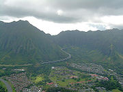 One anecdote relates to the elevated section passing through Haikū Valley
. In this valley, the viaduct passed beneath the antenna of a United States Coast Guard
radio transmission facility. It was thought that the energy field from the antenna could interfere with heart pacemakers—a potential detriment to drivers and passengers on the roadway. A giant metal cage was designed to surround the roadway through the valley. Before H-3 was opened, the Coast Guard closed their transmitting facility, obviating the need for the cage. Although the full cage was never built, buried within the roadway was the bottom of the cage. HDOT decided to remove this steel mesh (at considerable expense) prior to opening of the freeway to minimize inconvenience to the motoring public at some later time.
.
United States
The United States of America is a federal constitutional republic comprising fifty states and a federal district...
. H-3 is also known as the John A. Burns
John A. Burns
John Anthony Burns served as the second Governor of Hawaii from 1962 to 1974. Born in Fort Assinniboine, Montana, Burns was a resident of Hawaii from 1913....
Freeway. It crosses the Ko'olau Range along a viaduct and through the 5165 feet (1.6 km) long Tetsuo Harano Tunnels
Tetsuo Harano Tunnels
The Tetsuo Harano Tunnels are a pair of highway tunnels passing through the Ko‘olau Range on the island of O‘ahu. The tunnels are located on Interstate H-3, which connects Kaneohe with Interstate H-1 at Hālawa near Pearl Harbor, and are long Kaneohe-bound and long Halawa-bound.The tunnels are...
as well as the much smaller Hospital Rock Tunnels
Hospital Rock Tunnels
The Hospital Rock Tunnels are a small pair of highway tunnels passing through a ridge on the edge of the Ko‘olau Range on the island of O‘ahu, Hawaiʻi, USA. The tunnels are located on Interstate H-3, which connects Kaneohe with Interstate H-1 at Hālawa near Pearl Harbor, and are long Kaneohe bound...
.
Despite the number, signage is that of an east–west highway. Its western terminus is at an intersection of Interstate H-1
Interstate H-1
Interstate H-1 is the busiest Interstate Highway in Hawaii, United States, located on the island of O‘ahu. Despite the number, this is an east–west highway—the 'H'-series numbering reflects the order in which routes were funded and built. H-1 goes from Route 93 in Kapolei to Route 72 in...
at Hālawa near Pearl Harbor
Pearl Harbor
Pearl Harbor, known to Hawaiians as Puuloa, is a lagoon harbor on the island of Oahu, Hawaii, west of Honolulu. Much of the harbor and surrounding lands is a United States Navy deep-water naval base. It is also the headquarters of the U.S. Pacific Fleet...
. Its eastern end is at the main gate of Marine Corps Base Hawaii
Marine Corps Base Hawaii
Marine Corps Base Hawaii , formerly Marine Corps Air Station, Kaneohe Bay and originally Naval Air Station Kaneohe Bay, is a U.S. Marine Corps base facility and air station located on the Mokapu Peninsula of windward O'ahu in the City & County of Honolulu. As of the 2000 Census, the base had a...
(MCBH). This route satisfies the national defense purpose of connecting the Marine Corps base with the U.S. Navy port at Pearl Harbor off Interstate H-1.
Orders for the freeway were granted in 1960, followed by planning stages. Construction, amid enormous community protest, was begun in the late 1980s, although the road did not open until December 12, 1997. Environmental complaints and legal challenges halted construction at many points. Construction resumed during the late 1980s due to an unprecedented move by U.S. Senator
United States Senate
The United States Senate is the upper house of the bicameral legislature of the United States, and together with the United States House of Representatives comprises the United States Congress. The composition and powers of the Senate are established in Article One of the U.S. Constitution. Each...
Daniel Inouye
Daniel Inouye
Daniel Ken "Dan" Inouye is the senior United States Senator from Hawaii, a member of the Democratic Party, and the President pro tempore of the United States Senate making him the highest-ranking Asian American politician in American history. Inouye is the chairman of the United States Senate...
, who in 1986 had the freeway exempted from most environmental law
Environmental law
Environmental law is a complex and interlocking body of treaties, conventions, statutes, regulations, and common law that operates to regulate the interaction of humanity and the natural environment, toward the purpose of reducing the impacts of human activity...
s as a rider
Rider (legislation)
In legislative procedure, a rider is an additional provision added to a bill or other measure under the consideration by a legislature, having little connection with the subject matter of the bill. Riders are usually created as a tactic to pass a controversial provision that would not pass as its...
on a Department of Defense
United States Department of Defense
The United States Department of Defense is the U.S...
budget bill
Bill (proposed law)
A bill is a proposed law under consideration by a legislature. A bill does not become law until it is passed by the legislature and, in most cases, approved by the executive. Once a bill has been enacted into law, it is called an act or a statute....
.
H-3 is one of the most expensive Interstate Highways ever built, on a cost per mile basis. Its final cost was $1.3 billion, or approximately $80 million per mile.
Route description
Interstate H-1
Interstate H-1 is the busiest Interstate Highway in Hawaii, United States, located on the island of O‘ahu. Despite the number, this is an east–west highway—the 'H'-series numbering reflects the order in which routes were funded and built. H-1 goes from Route 93 in Kapolei to Route 72 in...
and H-201
Interstate H-201
Interstate H-201 is an auxiliary Interstate Highway located on the island of O‘ahu in the U.S. state of Hawaii. The H-201 is also known as the Moanalua Freeway...
. The freeway then runs along a viaduct through Hālawa Valley for about 6 miles (9.7 km) until it reaches the Tetsuo Harano Tunnels
Tetsuo Harano Tunnels
The Tetsuo Harano Tunnels are a pair of highway tunnels passing through the Ko‘olau Range on the island of O‘ahu. The tunnels are located on Interstate H-3, which connects Kaneohe with Interstate H-1 at Hālawa near Pearl Harbor, and are long Kaneohe-bound and long Halawa-bound.The tunnels are...
through the Ko'olau Mountains. Once on the eastern end of the tunnel, the freeway follows a viaduct built along the side of Haiku Valley until the Kaneohe Interchange with State Route 63 (Likelike Highway) which leads into the town of Kaneohe. The freeway then continues to the Halekou Interchange with State Route 83 (Kamehameha Highway
Kamehameha Highway
Kamehameha Highway is one of the main highways serving suburban and rural O‘ahu in the U.S. state of Hawaii. Starting from Nimitz Highway near Pearl Harbor and Hickam Air Force Base in Honolulu, it serves the island's older western suburbs, turning north across the O‘ahu Central Valley to the...
), then for four more miles until it reaches the main gate of Marine Corps Base Hawaii
Marine Corps Base Hawaii
Marine Corps Base Hawaii , formerly Marine Corps Air Station, Kaneohe Bay and originally Naval Air Station Kaneohe Bay, is a U.S. Marine Corps base facility and air station located on the Mokapu Peninsula of windward O'ahu in the City & County of Honolulu. As of the 2000 Census, the base had a...
.
History
Moanalua
Moanalua is a valley, a stream, an ahupuaa, and a residential neighborhood in Honolulu, Hawaii. The valley extends inland from behind Āliapaakai crater to the crest of the Koʻolau Range....
ahupua'a. The powerful Damon family hurried to create the Moanalua Gardens Foundation in 1970 to join the forces of all political and cultural groups who opposed the freeway's construction through their tract of land. The Foundation's pinnacle no-build argument was the need to remove a significant historical stone containing ancient petroglyphs, Pohaku ka Luahine, which, until this day, stands intact along the Moanalua valley trail. Success came their way as this freeway route was dropped, but the H-3 would merely be rerouted.
Light pollution
Light pollution, also known as photopollution or luminous pollution, is excessive or obtrusive artificial light.The International Dark-Sky Association defines light pollution as:...
, asbestos
Asbestos
Asbestos is a set of six naturally occurring silicate minerals used commercially for their desirable physical properties. They all have in common their eponymous, asbestiform habit: long, thin fibrous crystals...
pollution, water and streamlife problems, and a host of other concerns; most notable among these are the ongoing decline of pueo
Pueo
The Pueo is a subspecies of Short-eared owl that is endemic to Hawaii. The pueo is one of the various nā aumākua in Hawaiian culture....
, and other native birds, including several probable extinctions. For example, the O‘ahu ‘Alauahio (Paroreomyza maculata) was probably made extinct by H-3, as the species, whose last known home was Halawa, has had no sightings since H-3 construction.
Longtime residents of Ko'olaupoko
North Ko'olaupoko, Hawai'i
North Koolaupoko is a census-designated place in the City & County of Honolulu, Hawaii, United States, on the island of Oahu. The population was 726 at the 2000 census. In Hawaiian, koolau poko means "short windward", referring to the fact that this is the shorter of the two windward districts on...
and other North Shore
North Shore (Oahu)
The North Shore, in the context of geography of the Island of Oahu, refers to the north-facing coastal area of Oahu between Kaena Point and Kahuku Point...
communities continue to object to the freeway's developmental impacts on their community. Among their primary fears are urbanization on the scale of Honolulu via the freeway, which has the potential to bring heavy traffic and growth into their traditionally quiet neighborhoods, as well as affecting the value of their homes in the (until recently) relatively rural communities.
Conversely, this road is considered an engineering wonder by its admirers. It is often compared to various cinematic landscapes in Star Wars
Star Wars
Star Wars is an American epic space opera film series created by George Lucas. The first film in the series was originally released on May 25, 1977, under the title Star Wars, by 20th Century Fox, and became a worldwide pop culture phenomenon, followed by two sequels, released at three-year...
and other movies, and it does sometimes reduce travel time for cross-island commuters, which has allowed for increased real estate development and prices in Windward Oahu (east of the Koolau Mountains, although frequent traffic clogs and accidents have become a well-known feature of the road as well.
Haiku Valley
Haikū Valley is an amphitheater-shaped valley on the windward side of the Koolau Range behind Kāneohe, Oahu in the Hawaiian Islands. The valley was the site of a United States Navy radio transmitting station and is part of the route of Hawaii's Interstate H-3.The valley is most noteworthy today...
. In this valley, the viaduct passed beneath the antenna of a United States Coast Guard
United States Coast Guard
The United States Coast Guard is a branch of the United States Armed Forces and one of the seven U.S. uniformed services. The Coast Guard is a maritime, military, multi-mission service unique among the military branches for having a maritime law enforcement mission and a federal regulatory agency...
radio transmission facility. It was thought that the energy field from the antenna could interfere with heart pacemakers—a potential detriment to drivers and passengers on the roadway. A giant metal cage was designed to surround the roadway through the valley. Before H-3 was opened, the Coast Guard closed their transmitting facility, obviating the need for the cage. Although the full cage was never built, buried within the roadway was the bottom of the cage. HDOT decided to remove this steel mesh (at considerable expense) prior to opening of the freeway to minimize inconvenience to the motoring public at some later time.
Exit list
The entire route is in Honolulu CountyHonolulu County, Hawaii
The City and County of Honolulu is a consolidated city–county located in the U.S. state of Hawaii. The municipality and county includes both the urban district of Honolulu and the rest of the island of Oahu, as well as several minor outlying islands, including all of the Northwestern Hawaiian...
.
| Location | Mile | Exit | Destinations | Notes |
|---|---|---|---|---|
| Halawa Halawa, Hawaii Halawa is a census-designated place in the ‘Ewa District of Honolulu County, Hawaii, United States. Halawa Stream branches into two valleys: North and South Halawa; North Halawa is the larger stream and fluvial feature. Their confluence is within the H-3/H-201 highways exchange. Most of Halawa... |
0.00 | Left unnumbered exit; westbound exit and eastbound entrance | ||
| 0.00 | 1A | Westbound exit and eastbound entrance | ||
| 0.13 | 1B | |||
| 0.51 | 1C | Westbound exit only | ||
| >colspan=3 align=center|Tetsuo Harano Tunnel under Ko‘olau Range | ||||
| Kaneohe | 8.23 | 9 | Eastbound exit and westbound entrance | |
| 9.91 | 11 | |||
| 12.20 | ||||
| 14 | Eastbound exit and westbound entrance | |||
| Malae | 13.83 | 15 | Kaneohe Bay Drive | |
| 13.83 | Kaneohe MCBH Marine Corps Base Hawaii Marine Corps Base Hawaii , formerly Marine Corps Air Station, Kaneohe Bay and originally Naval Air Station Kaneohe Bay, is a U.S. Marine Corps base facility and air station located on the Mokapu Peninsula of windward O'ahu in the City & County of Honolulu. As of the 2000 Census, the base had a... |
Continuation beyond Kaneohe Bay Drive |