
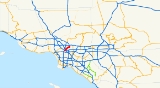
Pasadena Freeway
Encyclopedia
The Arroyo Seco Parkway, formerly known as the Pasadena Freeway, is the first freeway in California
and the western United States
. It connects Los Angeles
with Pasadena
alongside the Arroyo Seco
. It is notable not only for being the first, mostly opened in 1940, but for representing the transitional phase between early parkway
s and modern freeways. It conformed to modern standards when it was built, but is now regarded as a narrow, outdated roadway. A 1953 extension brought the south end to the Four Level Interchange
in downtown Los Angeles
and a connection with the rest of the freeway system.
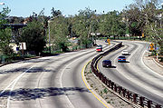
The road remains largely as it was on opening day, though the plants in its median have given way to a steel guard rail
, and it now carries the designation State Route 110, not historic U.S. Route 66. Between 1954 and 2010, it was officially designated the Pasadena Freeway. In 2010, as part of plans to revitalize its scenic value and improve safety, Caltrans renamed the roadway back to its original name. All the bridges built during parkway construction remain, as do four older bridges that crossed the Arroyo Seco before the 1930s. The Arroyo Seco Parkway is designated a State Scenic Highway, National Civil Engineering Landmark, and National Scenic Byway
. It was listed in the National Register of Historic Places
in 2011.
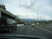 The six-lane Arroyo Seco Parkway (part of State Route 110) begins at the Four Level Interchange
, a symmetrical stack interchange
on the north side of downtown Los Angeles
that connects the Pasadena (SR 110 north), Harbor (SR 110 south), Hollywood (US 101 north), and Santa Ana
(US 101 south) Freeways. The first interchange is with the north end of Figueroa Street
at Alpine Street, and the freeway then meets the north end of Hill Street
at a complicated junction that provides access to Dodger Stadium
. Beyond Hill Street, SR 110 temporarily widens to four northbound and five southbound lanes as it enters the hilly Elysian Park
, where the northbound lanes pass through the four Figueroa Street Tunnels
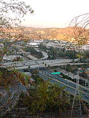
and the higher southbound lanes pass through a cut and over low areas on bridges. One interchange, with Solano Avenue and Amador Street, is located between the first and second tunnels. Just beyond the last tunnel is a northbound left exit and corresponding southbound right entrance for Riverside Drive and the northbound Golden State Freeway (I-5). Immediately after those ramps, the Arroyo Seco Parkway crosses a pair of three-lane bridges over the Los Angeles River
just northwest of its confluence with the Arroyo Seco, one rail line on each bank, and Avenue 19 and San Fernando Road
on the north bank. A single onramp from San Fernando Road joins SR 110 northbound as it passes under I-5, and a northbound left exit and southbound right entrance connect to the north segment of Figueroa Street
. Here the original 1940 freeway, mostly built along the west bank of the Arroyo Seco, begins as the southbound lanes curve from their 1943 alignment over the Los Angeles River into the original alignment next to the northbound lanes.
 As the original freeway begins, it passes under an extension to the 1925 Avenue 26 Bridge, one of four bridges over the Arroyo Seco that predate the parkway's construction. A southbound exit and northbound entrance at Avenue 26 complement the Figueroa Street ramps, and similar ramps connect Pasadena to both directions of I-5. SR 110 continues northeast alongside the Arroyo Seco, passing under the Gold Line light rail
and Pasadena Avenue before junctioning Avenue 43 at the first of many folded diamond interchanges that feature extremely tight (right-in/right-out
) curves on the exit and entrance ramps. The next interchange, at Avenue 52, is a normal diamond interchange
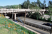
, and soon after is Via Marisol, where the northbound side has standard diamond ramps, but on the southbound side Avenue 57 acts as a folded diamond connection. The 1926 Avenue 60 Bridge is the second original bridge, and is another folded diamond, with southbound traffic using Shults Street to connect. The 1895 Santa Fe Arroyo Seco Railroad Bridge
(now Gold Line) lies just beyond, and after that is a half diamond interchange at Marmion Way/Avenue 64 with access towards Los Angeles only. After the freeway passes under the 1912 York Boulevard Bridge, the pre-parkway bridge, southbound connections between the freeway and cross street can be made via Salonica Street. As the Arroyo Seco curves north to pass west of downtown Pasadena, the Arroyo Seco Parkway instead curves east, crossing the stream into South Pasadena. A single northbound offramp on the Los Angeles side of the bridge curves left under the bridge to Bridewell Street, the parkway's west-side frontage road
.
 As they enter South Pasadena, northbound motorists can see a "City of South Pasadena" sign constructed, in the late 1930s, of stones from the creek bed embedded in a hillside. This final segment of the Arroyo Seco Parkway heads east in a cut alongside Grevelia Street, with a full diamond at Orange Grove Avenue and a half diamond at Fair Oaks Avenue. In between those two streets it crosses under the Gold Line for the third and final time. Beyond Fair Oaks Avenue, SR 110 curves north around the east side of Raymond Hill
and enters Pasadena, where the final ramp, a southbound exit, connects to State Street for access to Fair Oaks Avenue. The freeway, and state maintenance, ends at the intersection with Glenarm Street, but the six- and four-lane Arroyo Parkway, now maintained by the city of Pasadena, continues north as a surface road to Colorado Boulevard
(historic U.S. Route 66) and beyond to Holly Street near the Memorial Park
Gold Line station.
 The Arroyo Seco
(Spanish: "dry gulch, or streambed") is an intermittent stream that carries rainfall from the San Gabriel Mountains
southerly through western Pasadena into the Los Angeles River
near downtown Los Angeles
. During the dry season, it served as a faster wagon
connection between the two cities than the all-weather road on the present Huntington Drive
. The first known survey for a permanent roadway through the Arroyo was made by T.D. Allen of Pasadena in 1895, and in 1897 two more proposals were made, one for a scenic parkway
and the other for a commuter cycleway. The latter was partially constructed and opened by Horace Dobbins
, who incorporated the California Cycleway
Company and bought a six-mile (10 km) right-of-way from downtown Pasadena to Avenue 54 in Highland Park, Los Angeles
. Construction began in 1899, and about 1¼ miles (2 km) of the elevated wooden bikeway were opened on January 1, 1900, starting near Pasadena's Hotel Green
and ending near the Raymond Hotel. The majority of its route is now Edmondson Alley; a toll booth
was located near the north end, in the present Central Park. Due to the end of the bicycle craze of the 1890s and the existing Pacific Electric Railway
lines connecting Pasadena to Los Angeles, the cycleway did not and was not expected to turn a profit, and never extended beyond the Raymond Hotel into the Arroyo Seco. In the first decade of the 20th century, the structure was dismantled, and the wood sold for lumber
, and the Pasadena Rapid Transit Company, a failed venture headed by Dobbins to construct a streetcar line, acquired the right-of-way.
 Due to the rise of the automobile, most subsequent plans for the Arroyo Seco included a roadway, though they differed as to the purpose: some, influenced by the City Beautiful movement
, concentrated on the park, while others, particularly those backed by the Automobile Club of Southern California
(ACSC), had as their primary purpose a fast road connecting the two cities. The first plan that left the Arroyo Seco in South Pasadena to better serve downtown Pasadena was drawn up by Pasadena City Engineer Harvey W. Hincks in 1916 and supported by the Pasadena Chamber of Commerce and ACSC. Frederick Law Olmsted, Jr.
and Harland Bartholomew
's 1924 Major Street Traffic Plan for Los Angeles, while concentrating on traffic relief, and noting that the Arroyo Seco Parkway would be a major highway, suggested that it be built as a parkway
, giving motorists "a great deal of incidental recreation and pleasure". By the mid-1930s, plans for a primarily recreational parkway had been overshadowed by the need to carry large numbers of commuters.
Debates continued on the exact location of the parkway, in particular whether it would bypass downtown Pasadena. In the late 1920s, Los Angeles acquired properties between San Fernando Road
and Pasadena Avenue, and City Engineer Lloyd Aldrich began grading between Avenues 60 and 66 in the early 1930s. By June 1932, residents of Highland Park and Garvanza, who had paid special assessments to finance improvement of the park, became suspicious of what appeared to be a road, then graded along the Arroyo Seco's west side between Via Marisol and Princess Drive. Merchants on North Figueroa Street (then Pasadena Avenue) also objected, due to the loss of business they would suffer from a bypass. Work stopped while the interested parties could work out the details, although, in late 1932 and early 1933, Aldrich was authorized to grade a cheaper route along the east side between Avenue 35 and Via Marisol. To the north, Pasadena and South Pasadena endorsed in 1934 what was essentially Hincks's 1916 plan, but lacked the money to build it. A bill was introduced in 1935 to add the route to the state highway system, and after some debate a new Route 205 was created as a swap for the Palmdale-Wrightwood Route 186, as the legislature had just greatly expanded the system in 1933, and the California Highway Commission
opposed a further increase.
 To connect the proposed parkway with downtown Los Angeles, that city improved and extended North Figueroa Street
as a four-lane road to the Los Angeles River
, allowing drivers to bypass the congested North Broadway Bridge on the existing but underutilized Riverside Drive Bridge. A large part of the project lay within Elysian Park
, and four Art Deco
tunnel
s were built through the hills. The first three, between Solano Avenue and the river, opened in late 1931, and the fourth opened in mid-1936, completing the extension of Figueroa Street to Riverside Drive. As with the contemporary Ramona Boulevard east from downtown, grade separation
s were mostly built only where terrain dictated. For Figueroa Street, this meant that all crossings except College Street (built several years after the extension was completed), where a hill was cut through, were at grade
. The Figueroa Street Viaduct, connecting the Riverside Drive intersection with North Figueroa Street (then Dayton Avenue) across the Los Angeles River
, opened in mid-1937. Closer to downtown, an interchange
was built at Temple Street
in 1939.
 Although many South Pasadena residents opposed the division of the city that the parkway would bring, the city's voters elected supporters in the 1936 elections. The state, which had the power to put the road where it wished even had South Pasadena continued to oppose it, approved the route on April 4, 1936. The route used the Arroyo Seco's west bank to near Hough Street, where it crossed to the east and cut through South Pasadena to the south end of Broadway (now Arroyo Parkway) in Pasadena. Another project, the Arroyo Seco Flood Control Channel, was built by the Works Progress Administration
before and during construction of the parkway to avoid damages from future floods. A number of state engineers toured East Coast roads in early 1938, including Chicago's Lake Shore Drive
, full and modified cloverleaf interchange
s in Massachusetts
and New Jersey
, and Robert Moses
's parkway system in New York City
. The parkway was the first road built in California under a 1939 freeway law that allowed access to be completely limited to a number of specified points. Although, in some areas, it was possible to use a standard diamond interchange
, other locations required folded diamonds, or, as the engineers called them, "compressed cloverleafs", where local streets often took the place of dedicated ramps, ending at the parkway with a sharp right turn required to enter or exit. The highway was designed with two 11–12 foot (3.4-3.7 m) lanes and one ten-foot (3.0 m) shoulder
in each direction, with the wider inside (passing) lanes paved in black asphalt concrete
and the outside lanes paved in gray Portland cement concrete. The differently-colored lanes would encourage drivers to stay in their lanes. (By mid-1939, the state had decided to replace the shoulders with additional travel lanes for increased capacity; except on a short piece in South Pasadena, these were also paved with Portland cement. So that disabled vehicles could be safely removed from the roadway, about 50 "safety bays" were constructed in 1949 and 1950.) The engineers used a design speed
of 45 miles per hour (70 km/h), superelevating curves where necessary to accomplish this. (The road is now posted at 55 mph/90 km/h.) Despite the freeway design, many parkway characteristics were incorporated, such as plantings of mostly native flora alongside the road.
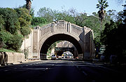
Prior to parkway construction, nine roads and two rail lines crossed the Arroyo Seco and its valley on bridges, and a number of new bridges were built as part of the project. Only four of the existing bridges were kept, albeit with some changes: the 1925 Avenue 26 Bridge, the 1926 Avenue 60 Bridge, the 1895 Santa Fe Arroyo Seco Railroad Bridge
(now part of the Gold Line) near Avenue 64, and the 1912 York Boulevard Bridge. The Avenue 43 Bridge would have been kept had the Los Angeles Flood of 1938
not destroyed it. At Cypress Avenue, abutment
s and a foundation were built for a roadway, but were not used until the 1960s, when a pedestrian bridge was built as part of the Golden State Freeway (I-5) interchange project. In South Pasadena, seven streets and one rail line were carried over the parkway to keep the communities on each side connected.
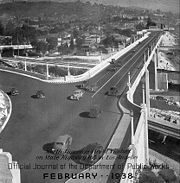
1940.jpg) Construction on the Arroyo Seco Parkway, designed under the leadership of District Chief Engineer Spencer V. Cortelyou and Design Engineer A. D. Griffin, began with a groundbreaking ceremony in South Pasadena on March 22, 1938 and generally progressed from Pasadena southwest. The first contract, stretching less than a mile (1.5 km) from Glenarm Street in Pasadena around Raymond Hill
Construction on the Arroyo Seco Parkway, designed under the leadership of District Chief Engineer Spencer V. Cortelyou and Design Engineer A. D. Griffin, began with a groundbreaking ceremony in South Pasadena on March 22, 1938 and generally progressed from Pasadena southwest. The first contract, stretching less than a mile (1.5 km) from Glenarm Street in Pasadena around Raymond Hill
to Fair Oaks Avenue in South Pasadena, and including no bridges, was opened to traffic on December 10, 1938. A 3.7-mile (6.0 km) section opened on July 20, 1940, connecting Orange Grove Avenue in South Pasadena with Avenue 40 in Los Angeles. The remainder in Los Angeles, from Avenue 40 southwest to the Figueroa Street Viaduct at Avenue 22, was opened on December 30, 1940, in time for the Tournament of Roses Parade
and Rose Bowl on New Year's Day
. However, the highway through South Pasadena was not completed until January 30, 1941, and landscaping work continued through September. The final cost of $5.75 million, under $1 million per mile, was extremely low for a freeway project because the terrain was favorable for grade separations.
 The state began upgrading the four-lane North Figueroa Street extension (then part of Route 165) in October 1940 as a "Southerly Extension" of the parkway, even before the parkway was complete. The at-grade intersection with Riverside Drive was already a point of congestion, and the six lanes of parkway narrowing into four lanes of surface street would cause much greater problems. The two-way Figueroa Street Tunnels and Viaduct were repurposed for four lanes of northbound traffic, and a higher southbound roadway was built to the west. From the split with Hill Street
south to near the existing College Street overpass, the four-lane surface road became a six-lane freeway. The extension was designed almost entirely on freeway, rather than parkway, principles, as it had to be built quickly to handle existing traffic. The new road split from the old at the Figueroa Street interchange, just south of Avenue 26, and crossed the Los Angeles River
and the northbound access to Riverside Drive on a new three-lane bridge. Through Elysian Park, a five-lane open cut was excavated west of the existing northbound tunnel lanes, saving about $1 million. The extension, still feeding into surface streets just south of College Street, was opened to traffic on December 30, 1943, again allowing its use for the New Year's Day festivities.
 While the Arroyo Seco Parkway was being built and extended, the region's freeway system was taking shape. The short city-built Cahuenga Pass Freeway opened on June 15, 1940, over a month before the second piece of the Arroyo Seco Parkway was complete. In the next two decades, the Harbor, Hollywood (Cahuenga Pass), Long Beach (Los Angeles River), San Bernardino
(Ramona), and Santa Ana
Freeways were partially or fully completed to their eponym
ous destinations, and others were under construction. The centerpiece of the system was the Four Level Interchange
just north of downtown Los Angeles
, the first stack interchange
in the world. Although it was completed in 1949, the structure was not fully used until September 22, 1953, when the short extension of the Arroyo Seco Parkway to the interchange opened. Though the common name used by the public had become "Arroyo Seco Freeway" over the years, it was officially a "Parkway" until November 16, 1954, when the California Highway Commission
changed its name to the Pasadena Freeway.
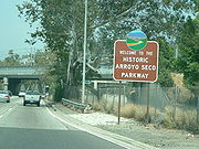
Beginning in June 2010, the state began modifying interchange signs to remove the Pasadena Freeway name and reinstate the Arroyo Seco Parkway name. Signs that indicate route 110 as a "freeway" are being modified to "parkway" or its "Pkwy" abbreviation.
 Despite a quadrupling of traffic volumes, the original roadway north of the Los Angeles River largely remains as it was when it opened in 1940. Truck
s and bus
es were banned in 1943, though the bus restriction has since been dropped; this has kept the freeway in good condition and relatively safe, despite its outdated design. This design, state-of-the-art when built, includes tight "right-in/right-out
" access with a recommended exit speed of 5 miles per hour (10 km/h) and stop sign
s on the entrance ramps; there are no acceleration or deceleration lanes. While the curves are banked for higher speeds, they were designed at half the modern standard. Except for the Golden State Freeway (I-5) interchange near the river, completed in 1962, the few structural changes to the freeway north of the river include the closure of the original southbound exit to Fair Oaks Avenue after its location on a curve proved dangerous and the replacement of shrubs in the 4-foot (1.2 m) median with a steel guard rail
. Los Angeles paid for reconstruction of the interchange at Hill Street, south of Elysian Park, in the early 1960s to serve the new Dodger Stadium
.
When the Arroyo Seco Parkway opened, it was the first freeway in California and the western United States. It became a new alignment of U.S. Route 66, and the old routing via Figueroa Street
and Colorado Boulevard
became U.S. Route 66 Alternate. The southern extension over the Los Angeles River to downtown Los Angeles also carried State Route 11 (which remained on the old route when US 66 was moved) and U.S. Routes 6 and 99 (which followed Avenue 26 and San Fernando Road
to the northwest). The 1964 renumbering saw US 66 truncated to Pasadena, and SR 11 was moved from Figueroa Street (which became SR 159) to the Pasadena Freeway. Finally, the number was changed to SR 110 in 1981, when SR 11 between San Pedro and the Santa Monica Freeway (I-10) became I-110.
 The Arroyo Seco Parkway remains the most direct route between downtown Los Angeles and Pasadena despite its flaws; the only reasonable freeway alternate (which trucks must use) is the Glendale Freeway (SR 2) to the west, which is itself not easily reached by trucks from downtown Los Angeles. The Gold Line light rail
, opened in 2003 over the former Santa Fe Railway line, provides an alternate mode for commuters. The state legislature designated the original section, north of the Figueroa Street Viaduct, as a "California Historic Parkway" (part of the State Scenic Highway System
reserved for freeways built before 1945) in 1993; the only other highway so designated is the Cabrillo Freeway (SR 163) in San Diego. The American Society of Civil Engineers
named it a National Civil Engineering Landmark in 1999, and it became a National Scenic Byway
in 2002. Occidental College
hosted the "ArroyoFest Freeway Walk and Bike Ride" on Sunday, June 15, 2003, closing the freeway to motor vehicles to "highlight several ongoing or proposed projects within the Arroyo that can improve the quality of life for everyone in the area".
California
California is a state located on the West Coast of the United States. It is by far the most populous U.S. state, and the third-largest by land area...
and the western United States
United States
The United States of America is a federal constitutional republic comprising fifty states and a federal district...
. It connects Los Angeles
Los Angeles, California
Los Angeles , with a population at the 2010 United States Census of 3,792,621, is the most populous city in California, USA and the second most populous in the United States, after New York City. It has an area of , and is located in Southern California...
with Pasadena
Pasadena, California
Pasadena is a city in Los Angeles County, California, United States. Although famous for hosting the annual Rose Bowl football game and Tournament of Roses Parade, Pasadena is the home to many scientific and cultural institutions, including the California Institute of Technology , the Jet...
alongside the Arroyo Seco
Arroyo Seco (Los Angeles County)
The Arroyo Seco, meaning "dry stream" in Spanish, is a seasonal river, canyon, watershed, and cultural area in Los Angeles County, California, United States. The Arroyo Seco has been called the most celebrated canyon in Southern California.-River course:...
. It is notable not only for being the first, mostly opened in 1940, but for representing the transitional phase between early parkway
Parkway
The term parkway has several distinct principal meanings and numerous synonyms around the world, for either a type of landscaped area or a type of road.Type of landscaped area:...
s and modern freeways. It conformed to modern standards when it was built, but is now regarded as a narrow, outdated roadway. A 1953 extension brought the south end to the Four Level Interchange
Four Level Interchange
The Four Level Interchange was the first stack interchange in the world. Completed in 1949 and fully opened in 1953 at the northern edge of downtown Los Angeles, California, USA, it connects U.S...
in downtown Los Angeles
Downtown Los Angeles
Downtown Los Angeles is the central business district of Los Angeles, California, United States, located close to the geographic center of the metropolitan area...
and a connection with the rest of the freeway system.
The road remains largely as it was on opening day, though the plants in its median have given way to a steel guard rail
Guard rail
Guard rail or guardrail, sometimes referred to as guide rail or railing, is a system designed to keep people or vehicles from straying into dangerous or off-limits areas...
, and it now carries the designation State Route 110, not historic U.S. Route 66. Between 1954 and 2010, it was officially designated the Pasadena Freeway. In 2010, as part of plans to revitalize its scenic value and improve safety, Caltrans renamed the roadway back to its original name. All the bridges built during parkway construction remain, as do four older bridges that crossed the Arroyo Seco before the 1930s. The Arroyo Seco Parkway is designated a State Scenic Highway, National Civil Engineering Landmark, and National Scenic Byway
National Scenic Byway
A National Scenic Byway is a road recognized by the United States Department of Transportation for its archeological, cultural, historic, natural, recreational, and/or scenic qualities. The program was established by Congress in 1991 to preserve and protect the nation's scenic but often...
. It was listed in the National Register of Historic Places
National Register of Historic Places
The National Register of Historic Places is the United States government's official list of districts, sites, buildings, structures, and objects deemed worthy of preservation...
in 2011.
Route description
Four Level Interchange
The Four Level Interchange was the first stack interchange in the world. Completed in 1949 and fully opened in 1953 at the northern edge of downtown Los Angeles, California, USA, it connects U.S...
, a symmetrical stack interchange
Stack interchange
A stack interchange is a free-flowing grade separated junction between two roads.In countries where one drives on the right, left turns are handled by semi-directional flyover/under ramps...
on the north side of downtown Los Angeles
Downtown Los Angeles
Downtown Los Angeles is the central business district of Los Angeles, California, United States, located close to the geographic center of the metropolitan area...
that connects the Pasadena (SR 110 north), Harbor (SR 110 south), Hollywood (US 101 north), and Santa Ana
Santa Ana Freeway
The Santa Ana Freeway is one of the principal freeways in Southern California, connecting Los Angeles and its southeastern suburbs including the freeway's namesake, the city of Santa Ana. The freeway begins at the Four Level Interchange in downtown Los Angeles, signed as U.S. Route 101...
(US 101 south) Freeways. The first interchange is with the north end of Figueroa Street
Figueroa Street
Figueroa Street is a street in Los Angeles County, California named for General José Figueroa , governor of Alta California from 1833 to 1835, who oversaw the secularization of the missions of California...
at Alpine Street, and the freeway then meets the north end of Hill Street
Hill Street (Los Angeles)
Hill Street is a major north-south thoroughfare in Los Angeles, measuring 4.8 miles in length. It starts on Martin Luther King, Jr. Boulevard near the campus of USC, and passes north through Downtown Los Angeles, past such landmarks as Pershing Square, the Subway Terminal Building, Angels Flight,...
at a complicated junction that provides access to Dodger Stadium
Dodger Stadium
Dodger Stadium, also sometimes called Chavez Ravine, is a stadium in Los Angeles. Located adjacent to Downtown Los Angeles, Dodger Stadium has been the home ballpark of Major League Baseball's Los Angeles Dodgers team since 1962...
. Beyond Hill Street, SR 110 temporarily widens to four northbound and five southbound lanes as it enters the hilly Elysian Park
Elysian Park, Los Angeles, California
Elysian Park is a park and adjacent neighborhood in the City of Los Angeles, California.Encompassing Chavez Ravine where Dodger Stadium is located, Elysian Park is mostly a hillside community that is also home to the Los Angeles Police Academy....
, where the northbound lanes pass through the four Figueroa Street Tunnels
Figueroa Street Tunnels
The Figueroa Street Tunnels are a set of four four-lane tunnels that carry northbound traffic on State Route 110 through Elysian Park in Los Angeles, California, United States. From south to north, the four tunnels measure 755, 461, 130 and 405 feet in length, 46.5 feet in width, and...
and the higher southbound lanes pass through a cut and over low areas on bridges. One interchange, with Solano Avenue and Amador Street, is located between the first and second tunnels. Just beyond the last tunnel is a northbound left exit and corresponding southbound right entrance for Riverside Drive and the northbound Golden State Freeway (I-5). Immediately after those ramps, the Arroyo Seco Parkway crosses a pair of three-lane bridges over the Los Angeles River
Los Angeles River
The Los Angeles River is a river that starts in the San Fernando Valley, in the Simi Hills and Santa Susana Mountains, and flows through Los Angeles County, California, from Canoga Park in the western end of the San Fernando Valley, nearly southeast to its mouth in Long Beach...
just northwest of its confluence with the Arroyo Seco, one rail line on each bank, and Avenue 19 and San Fernando Road
San Fernando Road
San Fernando Road is a major street in the city and county of Los Angeles. It starts off in Castaic as The Old Road, passing through Santa Clarita and the Newhall Pass, whereupon its intersection with Sierra Highway near the junction of the Golden State and the Antelope Valley Freeways, it...
on the north bank. A single onramp from San Fernando Road joins SR 110 northbound as it passes under I-5, and a northbound left exit and southbound right entrance connect to the north segment of Figueroa Street
Figueroa Street
Figueroa Street is a street in Los Angeles County, California named for General José Figueroa , governor of Alta California from 1833 to 1835, who oversaw the secularization of the missions of California...
. Here the original 1940 freeway, mostly built along the west bank of the Arroyo Seco, begins as the southbound lanes curve from their 1943 alignment over the Los Angeles River into the original alignment next to the northbound lanes.
Light rail
Light rail or light rail transit is a form of urban rail public transportation that generally has a lower capacity and lower speed than heavy rail and metro systems, but higher capacity and higher speed than traditional street-running tram systems...
and Pasadena Avenue before junctioning Avenue 43 at the first of many folded diamond interchanges that feature extremely tight (right-in/right-out
Right-in/right-out
Right-in/right-out and left-in/left-out refer to a type of road intersection where turning movements of vehicles are restricted. A RIRO permits only right turns and a LILO permits only left turns. RIRO is usual where vehicles drive on the right, and LILO is usual where vehicles drive on the left...
) curves on the exit and entrance ramps. The next interchange, at Avenue 52, is a normal diamond interchange
Diamond interchange
A diamond interchange is a common type of road junction, used where a freeway crosses a minor road. The freeway itself is grade-separated from the minor road, one crossing the other over a bridge...
, and soon after is Via Marisol, where the northbound side has standard diamond ramps, but on the southbound side Avenue 57 acts as a folded diamond connection. The 1926 Avenue 60 Bridge is the second original bridge, and is another folded diamond, with southbound traffic using Shults Street to connect. The 1895 Santa Fe Arroyo Seco Railroad Bridge
Santa Fe Arroyo Seco Railroad Bridge
Located at 162 S. Avenue 61 in Highland Park, this bridge is more than long and crosses the Pasadena freeway at an elevation of over . It the tallest and longest railroad span in the city of Los Angeles, and most likely the oldest such structure still in use....
(now Gold Line) lies just beyond, and after that is a half diamond interchange at Marmion Way/Avenue 64 with access towards Los Angeles only. After the freeway passes under the 1912 York Boulevard Bridge, the pre-parkway bridge, southbound connections between the freeway and cross street can be made via Salonica Street. As the Arroyo Seco curves north to pass west of downtown Pasadena, the Arroyo Seco Parkway instead curves east, crossing the stream into South Pasadena. A single northbound offramp on the Los Angeles side of the bridge curves left under the bridge to Bridewell Street, the parkway's west-side frontage road
Frontage road
A frontage road is a non-limited access road running parallel to a higher-speed road, usually a freeway, and feeding it at appropriate points of access...
.
Raymond Hill
Raymond Hill may refer to:* Ray Hill , American football player* Raymond Hill who played on "Rocket 88" and Junior Parker's "Mystery Train".* location of the Raymond Hotel...
and enters Pasadena, where the final ramp, a southbound exit, connects to State Street for access to Fair Oaks Avenue. The freeway, and state maintenance, ends at the intersection with Glenarm Street, but the six- and four-lane Arroyo Parkway, now maintained by the city of Pasadena, continues north as a surface road to Colorado Boulevard
Colorado Boulevard
Colorado Boulevard is a major east–west street in Southern California, United States. It runs from Griffith Park in Los Angeles east through Glendale, the Eagle Rock section of Los Angeles, Pasadena, and Arcadia, ending in Monrovia...
(historic U.S. Route 66) and beyond to Holly Street near the Memorial Park
Memorial Park (LACMTA station)
Memorial Park Station is a below-grade light rail station in the Los Angeles County Metro Rail system. It is located at Holly Street and Arroyo Parkway in Pasadena, California...
Gold Line station.
Planning
Arroyo Seco (Los Angeles County)
The Arroyo Seco, meaning "dry stream" in Spanish, is a seasonal river, canyon, watershed, and cultural area in Los Angeles County, California, United States. The Arroyo Seco has been called the most celebrated canyon in Southern California.-River course:...
(Spanish: "dry gulch, or streambed") is an intermittent stream that carries rainfall from the San Gabriel Mountains
San Gabriel Mountains
The San Gabriel Mountains Range is located in northern Los Angeles County and western San Bernardino County, California, United States. The mountain range lies between the Los Angeles Basin and the Mojave Desert, with Interstate 5 to the west and Interstate 15 to the east...
southerly through western Pasadena into the Los Angeles River
Los Angeles River
The Los Angeles River is a river that starts in the San Fernando Valley, in the Simi Hills and Santa Susana Mountains, and flows through Los Angeles County, California, from Canoga Park in the western end of the San Fernando Valley, nearly southeast to its mouth in Long Beach...
near downtown Los Angeles
Downtown Los Angeles
Downtown Los Angeles is the central business district of Los Angeles, California, United States, located close to the geographic center of the metropolitan area...
. During the dry season, it served as a faster wagon
Wagon
A wagon is a heavy four-wheeled vehicle pulled by draught animals; it was formerly often called a wain, and if low and sideless may be called a dray, trolley or float....
connection between the two cities than the all-weather road on the present Huntington Drive
Huntington Drive
Huntington Drive is a major east–west street in Southern California. It runs from the merge of Soto Street and Mission Road near the Lincoln Park neighborhood of Los Angeles east through the El Sereno section of Los Angeles, South Pasadena, San Marino, Alhambra, San Gabriel, Arcadia,...
. The first known survey for a permanent roadway through the Arroyo was made by T.D. Allen of Pasadena in 1895, and in 1897 two more proposals were made, one for a scenic parkway
Parkway
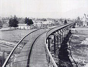
The term parkway has several distinct principal meanings and numerous synonyms around the world, for either a type of landscaped area or a type of road.Type of landscaped area:...
and the other for a commuter cycleway. The latter was partially constructed and opened by Horace Dobbins
Horace Dobbins
Horace Dobbins was Mayor of Pasadena, California, United States in 1900-1901. He was known for building the California Cycleway from Pasadena to Los Angeles.-External links:...
, who incorporated the California Cycleway
California Cycleway
The California Cycleway, opened in 1900, was an elevated tollway built specially for bicycle traffic through the Arroyo Seco, intended to connect the cities of Pasadena and Los Angeles, in California, United States....
Company and bought a six-mile (10 km) right-of-way from downtown Pasadena to Avenue 54 in Highland Park, Los Angeles
Highland Park, Los Angeles, California
Highland Park is a neighborhood in Northeast Los Angeles.-Geography:Highland Park is located along the Arroyo Seco. It is situated within what was once Rancho San Rafael of the Spanish / Mexican era...
. Construction began in 1899, and about 1¼ miles (2 km) of the elevated wooden bikeway were opened on January 1, 1900, starting near Pasadena's Hotel Green
Hotel Green
Historical information with regards to the fire that brought the old Hotel Green wooden structure down, is credited to the book Haunted Houses of Pasadena by Michael J. Kouri, a well known historian and Parapsychological Investigator....
and ending near the Raymond Hotel. The majority of its route is now Edmondson Alley; a toll booth
Toll house
A tollhouse or toll house is a building with accommodation for a toll collector, beside a tollgate on a toll road or canal. Many tollhouses were built by turnpike trusts in England, Wales and Scotland during the 18th and early 19th centuries...
was located near the north end, in the present Central Park. Due to the end of the bicycle craze of the 1890s and the existing Pacific Electric Railway
Pacific Electric Railway
The Pacific Electric Railway , also known as the Red Car system, was a mass transit system in Southern California using streetcars, light rail, and buses...
lines connecting Pasadena to Los Angeles, the cycleway did not and was not expected to turn a profit, and never extended beyond the Raymond Hotel into the Arroyo Seco. In the first decade of the 20th century, the structure was dismantled, and the wood sold for lumber
Lumber
Lumber or timber is wood in any of its stages from felling through readiness for use as structural material for construction, or wood pulp for paper production....
, and the Pasadena Rapid Transit Company, a failed venture headed by Dobbins to construct a streetcar line, acquired the right-of-way.
City Beautiful movement
The City Beautiful Movement was a reform philosophy concerning North American architecture and urban planning that flourished during the 1890s and 1900s with the intent of using beautification and monumental grandeur in cities. The movement, which was originally associated mainly with Chicago,...
, concentrated on the park, while others, particularly those backed by the Automobile Club of Southern California
Automobile Club of Southern California
The Automobile Club of Southern California is the Southern California affiliate of the American Automobile Association federation of motor clubs...
(ACSC), had as their primary purpose a fast road connecting the two cities. The first plan that left the Arroyo Seco in South Pasadena to better serve downtown Pasadena was drawn up by Pasadena City Engineer Harvey W. Hincks in 1916 and supported by the Pasadena Chamber of Commerce and ACSC. Frederick Law Olmsted, Jr.
Frederick Law Olmsted, Jr.
Frederick Law Olmsted, Jr. was an American landscape architect best known for his wildlife conservation efforts. He had a lifetime commitment to national parks, and worked on projects in Acadia, the Everglades and Yosemite National Park. Olmsted Point in Yosemite and Olmsted Island at Great Falls...
and Harland Bartholomew
Harland Bartholomew
Harland Bartholomew was an American urban planner. Although a civil engineer by training and disposition, Harland's career started just as the automobile production was about to take off, industrial development was booming and urban populations grew...
's 1924 Major Street Traffic Plan for Los Angeles, while concentrating on traffic relief, and noting that the Arroyo Seco Parkway would be a major highway, suggested that it be built as a parkway
Parkway
The term parkway has several distinct principal meanings and numerous synonyms around the world, for either a type of landscaped area or a type of road.Type of landscaped area:...
, giving motorists "a great deal of incidental recreation and pleasure". By the mid-1930s, plans for a primarily recreational parkway had been overshadowed by the need to carry large numbers of commuters.
Debates continued on the exact location of the parkway, in particular whether it would bypass downtown Pasadena. In the late 1920s, Los Angeles acquired properties between San Fernando Road
San Fernando Road
San Fernando Road is a major street in the city and county of Los Angeles. It starts off in Castaic as The Old Road, passing through Santa Clarita and the Newhall Pass, whereupon its intersection with Sierra Highway near the junction of the Golden State and the Antelope Valley Freeways, it...
and Pasadena Avenue, and City Engineer Lloyd Aldrich began grading between Avenues 60 and 66 in the early 1930s. By June 1932, residents of Highland Park and Garvanza, who had paid special assessments to finance improvement of the park, became suspicious of what appeared to be a road, then graded along the Arroyo Seco's west side between Via Marisol and Princess Drive. Merchants on North Figueroa Street (then Pasadena Avenue) also objected, due to the loss of business they would suffer from a bypass. Work stopped while the interested parties could work out the details, although, in late 1932 and early 1933, Aldrich was authorized to grade a cheaper route along the east side between Avenue 35 and Via Marisol. To the north, Pasadena and South Pasadena endorsed in 1934 what was essentially Hincks's 1916 plan, but lacked the money to build it. A bill was introduced in 1935 to add the route to the state highway system, and after some debate a new Route 205 was created as a swap for the Palmdale-Wrightwood Route 186, as the legislature had just greatly expanded the system in 1933, and the California Highway Commission
California Highway Commission
The California Highway Commission was established in 1895 and continued until 1978 as the primary state highway bureaucracy in California.Their first noticeable efforts centered on the Lake Tahoe Wagon Road over the Sierra Nevada mountains...
opposed a further increase.
Construction
Figueroa Street
Figueroa Street is a street in Los Angeles County, California named for General José Figueroa , governor of Alta California from 1833 to 1835, who oversaw the secularization of the missions of California...
as a four-lane road to the Los Angeles River
Los Angeles River
The Los Angeles River is a river that starts in the San Fernando Valley, in the Simi Hills and Santa Susana Mountains, and flows through Los Angeles County, California, from Canoga Park in the western end of the San Fernando Valley, nearly southeast to its mouth in Long Beach...
, allowing drivers to bypass the congested North Broadway Bridge on the existing but underutilized Riverside Drive Bridge. A large part of the project lay within Elysian Park
Elysian Park, Los Angeles, California
Elysian Park is a park and adjacent neighborhood in the City of Los Angeles, California.Encompassing Chavez Ravine where Dodger Stadium is located, Elysian Park is mostly a hillside community that is also home to the Los Angeles Police Academy....
, and four Art Deco
Art Deco
Art deco , or deco, is an eclectic artistic and design style that began in Paris in the 1920s and flourished internationally throughout the 1930s, into the World War II era. The style influenced all areas of design, including architecture and interior design, industrial design, fashion and...
tunnel
Tunnel
A tunnel is an underground passageway, completely enclosed except for openings for egress, commonly at each end.A tunnel may be for foot or vehicular road traffic, for rail traffic, or for a canal. Some tunnels are aqueducts to supply water for consumption or for hydroelectric stations or are sewers...
s were built through the hills. The first three, between Solano Avenue and the river, opened in late 1931, and the fourth opened in mid-1936, completing the extension of Figueroa Street to Riverside Drive. As with the contemporary Ramona Boulevard east from downtown, grade separation
Grade separation
Grade separation is the method of aligning a junction of two or more transport axes at different heights so that they will not disrupt the traffic flow on other transit routes when they cross each other. The composition of such transport axes does not have to be uniform; it can consist of a...
s were mostly built only where terrain dictated. For Figueroa Street, this meant that all crossings except College Street (built several years after the extension was completed), where a hill was cut through, were at grade
At-grade intersection
An at-grade intersection is a junction at which two or more transport axes cross at the same level .-Traffic management:With areas of high or fast traffic, an at-grade intersection normally requires a traffic control device such as a stop sign, traffic light or railway signal to manage conflicting...
. The Figueroa Street Viaduct, connecting the Riverside Drive intersection with North Figueroa Street (then Dayton Avenue) across the Los Angeles River
Los Angeles River
The Los Angeles River is a river that starts in the San Fernando Valley, in the Simi Hills and Santa Susana Mountains, and flows through Los Angeles County, California, from Canoga Park in the western end of the San Fernando Valley, nearly southeast to its mouth in Long Beach...
, opened in mid-1937. Closer to downtown, an interchange
Interchange (road)
In the field of road transport, an interchange is a road junction that typically uses grade separation, and one or more ramps, to permit traffic on at least one highway to pass through the junction without directly crossing any other traffic stream. It differs from a standard intersection, at which...
was built at Temple Street
Temple Street (Los Angeles)
Temple Street is a street in the City of Los Angeles, California. The street is an east-west thoroughfare that runs through Downtown Los Angeles parallel to the Hollywood Freeway between Virgil Avenue past Alameda Street to the banks of the Los Angeles River...
in 1939.
Works Progress Administration
The Works Progress Administration was the largest and most ambitious New Deal agency, employing millions of unskilled workers to carry out public works projects, including the construction of public buildings and roads, and operated large arts, drama, media, and literacy projects...
before and during construction of the parkway to avoid damages from future floods. A number of state engineers toured East Coast roads in early 1938, including Chicago's Lake Shore Drive
Lake Shore Drive
Lake Shore Drive is a mostly freeway-standard expressway running parallel with and alongside the shoreline of Lake Michigan through Chicago, Illinois, USA. Except for the portion north of Foster Avenue , Lake Shore Drive is designated as part of U.S...
, full and modified cloverleaf interchange
Cloverleaf interchange
A cloverleaf interchange is a two-level interchange in which left turns, reverse direction in left-driving regions, are handled by ramp roads...
s in Massachusetts
Massachusetts
The Commonwealth of Massachusetts is a state in the New England region of the northeastern United States of America. It is bordered by Rhode Island and Connecticut to the south, New York to the west, and Vermont and New Hampshire to the north; at its east lies the Atlantic Ocean. As of the 2010...
and New Jersey
New Jersey
New Jersey is a state in the Northeastern and Middle Atlantic regions of the United States. , its population was 8,791,894. It is bordered on the north and east by the state of New York, on the southeast and south by the Atlantic Ocean, on the west by Pennsylvania and on the southwest by Delaware...
, and Robert Moses
Robert Moses
Robert Moses was the "master builder" of mid-20th century New York City, Long Island, Rockland County, and Westchester County, New York. As the shaper of a modern city, he is sometimes compared to Baron Haussmann of Second Empire Paris, and is one of the most polarizing figures in the history of...
's parkway system in New York City
New York City
New York is the most populous city in the United States and the center of the New York Metropolitan Area, one of the most populous metropolitan areas in the world. New York exerts a significant impact upon global commerce, finance, media, art, fashion, research, technology, education, and...
. The parkway was the first road built in California under a 1939 freeway law that allowed access to be completely limited to a number of specified points. Although, in some areas, it was possible to use a standard diamond interchange
Diamond interchange
A diamond interchange is a common type of road junction, used where a freeway crosses a minor road. The freeway itself is grade-separated from the minor road, one crossing the other over a bridge...
, other locations required folded diamonds, or, as the engineers called them, "compressed cloverleafs", where local streets often took the place of dedicated ramps, ending at the parkway with a sharp right turn required to enter or exit. The highway was designed with two 11–12 foot (3.4-3.7 m) lanes and one ten-foot (3.0 m) shoulder
Shoulder (road)
A hard shoulder, or simply shoulder, is a reserved area by the verge of a road or motorway. Generally it is kept clear of motor vehicle traffic...
in each direction, with the wider inside (passing) lanes paved in black asphalt concrete
Asphalt concrete
Asphalt concrete is a composite material commonly used in construction projects such as road surfaces, airports and parking lots. It consists of asphalt and mineral aggregate mixed together, then laid down in layers and compacted...
and the outside lanes paved in gray Portland cement concrete. The differently-colored lanes would encourage drivers to stay in their lanes. (By mid-1939, the state had decided to replace the shoulders with additional travel lanes for increased capacity; except on a short piece in South Pasadena, these were also paved with Portland cement. So that disabled vehicles could be safely removed from the roadway, about 50 "safety bays" were constructed in 1949 and 1950.) The engineers used a design speed
Design speed
The design speed is a tool used to determine geometric features of a new road during road design. The design speed chosen for a highway is a major factor in choosing superelevation rates and radii of curves, sight distance, and the lengths of crest and sag vertical curves...
of 45 miles per hour (70 km/h), superelevating curves where necessary to accomplish this. (The road is now posted at 55 mph/90 km/h.) Despite the freeway design, many parkway characteristics were incorporated, such as plantings of mostly native flora alongside the road.
Prior to parkway construction, nine roads and two rail lines crossed the Arroyo Seco and its valley on bridges, and a number of new bridges were built as part of the project. Only four of the existing bridges were kept, albeit with some changes: the 1925 Avenue 26 Bridge, the 1926 Avenue 60 Bridge, the 1895 Santa Fe Arroyo Seco Railroad Bridge
Santa Fe Arroyo Seco Railroad Bridge
Located at 162 S. Avenue 61 in Highland Park, this bridge is more than long and crosses the Pasadena freeway at an elevation of over . It the tallest and longest railroad span in the city of Los Angeles, and most likely the oldest such structure still in use....
(now part of the Gold Line) near Avenue 64, and the 1912 York Boulevard Bridge. The Avenue 43 Bridge would have been kept had the Los Angeles Flood of 1938
Los Angeles Flood of 1938
The Los Angeles Flood of 1938 or 1938 Los Angeles flood was a major flooding event that was responsible for inundating much of Los Angeles, Orange, and Riverside counties, California, during early 1938...
not destroyed it. At Cypress Avenue, abutment
Abutment
An abutment is, generally, the point where two structures or objects meet. This word comes from the verb abut, which means adjoin or having common boundary. An abutment is an engineering term that describes a structure located at the ends of a bridge, where the bridge slab adjoins the approaching...
s and a foundation were built for a roadway, but were not used until the 1960s, when a pedestrian bridge was built as part of the Golden State Freeway (I-5) interchange project. In South Pasadena, seven streets and one rail line were carried over the parkway to keep the communities on each side connected.
Raymond Hill
Raymond Hill may refer to:* Ray Hill , American football player* Raymond Hill who played on "Rocket 88" and Junior Parker's "Mystery Train".* location of the Raymond Hotel...
to Fair Oaks Avenue in South Pasadena, and including no bridges, was opened to traffic on December 10, 1938. A 3.7-mile (6.0 km) section opened on July 20, 1940, connecting Orange Grove Avenue in South Pasadena with Avenue 40 in Los Angeles. The remainder in Los Angeles, from Avenue 40 southwest to the Figueroa Street Viaduct at Avenue 22, was opened on December 30, 1940, in time for the Tournament of Roses Parade
Tournament of Roses Parade
The Tournament of Roses Parade, better known as the Rose Parade, is "America's New Year Celebration", a festival of flower-covered floats, marching bands, equestrians and a college football game on New Year's Day , produced by the non-profit Pasadena Tournament of Roses Association.The annual...
and Rose Bowl on New Year's Day
New Year's Day
New Year's Day is observed on January 1, the first day of the year on the modern Gregorian calendar as well as the Julian calendar used in ancient Rome...
. However, the highway through South Pasadena was not completed until January 30, 1941, and landscaping work continued through September. The final cost of $5.75 million, under $1 million per mile, was extremely low for a freeway project because the terrain was favorable for grade separations.
Hill Street (Los Angeles)
Hill Street is a major north-south thoroughfare in Los Angeles, measuring 4.8 miles in length. It starts on Martin Luther King, Jr. Boulevard near the campus of USC, and passes north through Downtown Los Angeles, past such landmarks as Pershing Square, the Subway Terminal Building, Angels Flight,...
south to near the existing College Street overpass, the four-lane surface road became a six-lane freeway. The extension was designed almost entirely on freeway, rather than parkway, principles, as it had to be built quickly to handle existing traffic. The new road split from the old at the Figueroa Street interchange, just south of Avenue 26, and crossed the Los Angeles River
Los Angeles River
The Los Angeles River is a river that starts in the San Fernando Valley, in the Simi Hills and Santa Susana Mountains, and flows through Los Angeles County, California, from Canoga Park in the western end of the San Fernando Valley, nearly southeast to its mouth in Long Beach...
and the northbound access to Riverside Drive on a new three-lane bridge. Through Elysian Park, a five-lane open cut was excavated west of the existing northbound tunnel lanes, saving about $1 million. The extension, still feeding into surface streets just south of College Street, was opened to traffic on December 30, 1943, again allowing its use for the New Year's Day festivities.
San Bernardino Freeway
The San Bernardino Freeway, formerly known as the Ramona Freeway is a freeway in Los Angeles and Orange Counties in the southern part of the U.S. state of California. It refers to the following two segments:...
(Ramona), and Santa Ana
Santa Ana Freeway
The Santa Ana Freeway is one of the principal freeways in Southern California, connecting Los Angeles and its southeastern suburbs including the freeway's namesake, the city of Santa Ana. The freeway begins at the Four Level Interchange in downtown Los Angeles, signed as U.S. Route 101...
Freeways were partially or fully completed to their eponym
Eponym
An eponym is the name of a person or thing, whether real or fictitious, after which a particular place, tribe, era, discovery, or other item is named or thought to be named...
ous destinations, and others were under construction. The centerpiece of the system was the Four Level Interchange
Four Level Interchange
The Four Level Interchange was the first stack interchange in the world. Completed in 1949 and fully opened in 1953 at the northern edge of downtown Los Angeles, California, USA, it connects U.S...
just north of downtown Los Angeles
Downtown Los Angeles
Downtown Los Angeles is the central business district of Los Angeles, California, United States, located close to the geographic center of the metropolitan area...
, the first stack interchange
Stack interchange
A stack interchange is a free-flowing grade separated junction between two roads.In countries where one drives on the right, left turns are handled by semi-directional flyover/under ramps...
in the world. Although it was completed in 1949, the structure was not fully used until September 22, 1953, when the short extension of the Arroyo Seco Parkway to the interchange opened. Though the common name used by the public had become "Arroyo Seco Freeway" over the years, it was officially a "Parkway" until November 16, 1954, when the California Highway Commission
California Highway Commission
The California Highway Commission was established in 1895 and continued until 1978 as the primary state highway bureaucracy in California.Their first noticeable efforts centered on the Lake Tahoe Wagon Road over the Sierra Nevada mountains...
changed its name to the Pasadena Freeway.
Beginning in June 2010, the state began modifying interchange signs to remove the Pasadena Freeway name and reinstate the Arroyo Seco Parkway name. Signs that indicate route 110 as a "freeway" are being modified to "parkway" or its "Pkwy" abbreviation.
Post-construction
Truck
A truck or lorry is a motor vehicle designed to transport cargo. Trucks vary greatly in size, power, and configuration, with the smallest being mechanically similar to an automobile...
s and bus
Bus
A bus is a road vehicle designed to carry passengers. Buses can have a capacity as high as 300 passengers. The most common type of bus is the single-decker bus, with larger loads carried by double-decker buses and articulated buses, and smaller loads carried by midibuses and minibuses; coaches are...
es were banned in 1943, though the bus restriction has since been dropped; this has kept the freeway in good condition and relatively safe, despite its outdated design. This design, state-of-the-art when built, includes tight "right-in/right-out
Right-in/right-out
Right-in/right-out and left-in/left-out refer to a type of road intersection where turning movements of vehicles are restricted. A RIRO permits only right turns and a LILO permits only left turns. RIRO is usual where vehicles drive on the right, and LILO is usual where vehicles drive on the left...
" access with a recommended exit speed of 5 miles per hour (10 km/h) and stop sign
Stop sign
A Stop sign is a traffic sign to notify drivers that they must stop before proceeding.-Specifications:The Vienna Convention on Road Signs and Signals proposed standard stop sign diameters of 0.6, 0.9 or 1.2 metres. UK and New Zealand stop signs are 750, 900 or 1200 mm, according to sign...
s on the entrance ramps; there are no acceleration or deceleration lanes. While the curves are banked for higher speeds, they were designed at half the modern standard. Except for the Golden State Freeway (I-5) interchange near the river, completed in 1962, the few structural changes to the freeway north of the river include the closure of the original southbound exit to Fair Oaks Avenue after its location on a curve proved dangerous and the replacement of shrubs in the 4-foot (1.2 m) median with a steel guard rail
Guard rail
Guard rail or guardrail, sometimes referred to as guide rail or railing, is a system designed to keep people or vehicles from straying into dangerous or off-limits areas...
. Los Angeles paid for reconstruction of the interchange at Hill Street, south of Elysian Park, in the early 1960s to serve the new Dodger Stadium
Dodger Stadium
Dodger Stadium, also sometimes called Chavez Ravine, is a stadium in Los Angeles. Located adjacent to Downtown Los Angeles, Dodger Stadium has been the home ballpark of Major League Baseball's Los Angeles Dodgers team since 1962...
.
When the Arroyo Seco Parkway opened, it was the first freeway in California and the western United States. It became a new alignment of U.S. Route 66, and the old routing via Figueroa Street
Figueroa Street
Figueroa Street is a street in Los Angeles County, California named for General José Figueroa , governor of Alta California from 1833 to 1835, who oversaw the secularization of the missions of California...
and Colorado Boulevard
Colorado Boulevard
Colorado Boulevard is a major east–west street in Southern California, United States. It runs from Griffith Park in Los Angeles east through Glendale, the Eagle Rock section of Los Angeles, Pasadena, and Arcadia, ending in Monrovia...
became U.S. Route 66 Alternate. The southern extension over the Los Angeles River to downtown Los Angeles also carried State Route 11 (which remained on the old route when US 66 was moved) and U.S. Routes 6 and 99 (which followed Avenue 26 and San Fernando Road
San Fernando Road
San Fernando Road is a major street in the city and county of Los Angeles. It starts off in Castaic as The Old Road, passing through Santa Clarita and the Newhall Pass, whereupon its intersection with Sierra Highway near the junction of the Golden State and the Antelope Valley Freeways, it...
to the northwest). The 1964 renumbering saw US 66 truncated to Pasadena, and SR 11 was moved from Figueroa Street (which became SR 159) to the Pasadena Freeway. Finally, the number was changed to SR 110 in 1981, when SR 11 between San Pedro and the Santa Monica Freeway (I-10) became I-110.
Light rail
Light rail or light rail transit is a form of urban rail public transportation that generally has a lower capacity and lower speed than heavy rail and metro systems, but higher capacity and higher speed than traditional street-running tram systems...
, opened in 2003 over the former Santa Fe Railway line, provides an alternate mode for commuters. The state legislature designated the original section, north of the Figueroa Street Viaduct, as a "California Historic Parkway" (part of the State Scenic Highway System
State Scenic Highway System (California)
The State Scenic Highway System is a list of highways, mainly state highways, that have been designated by the California Department of Transportation as scenic highways. The California State Legislature, primarily through Section 263 of the Streets and Highways Code, makes highways eligible for...
reserved for freeways built before 1945) in 1993; the only other highway so designated is the Cabrillo Freeway (SR 163) in San Diego. The American Society of Civil Engineers
American Society of Civil Engineers
The American Society of Civil Engineers is a professional body founded in 1852 to represent members of the civil engineering profession worldwide. It is the oldest national engineering society in the United States. ASCE's vision is to have engineers positioned as global leaders who strive toward...
named it a National Civil Engineering Landmark in 1999, and it became a National Scenic Byway
National Scenic Byway
A National Scenic Byway is a road recognized by the United States Department of Transportation for its archeological, cultural, historic, natural, recreational, and/or scenic qualities. The program was established by Congress in 1991 to preserve and protect the nation's scenic but often...
in 2002. Occidental College
Occidental College
Occidental College is a private, coeducational liberal arts college located in the Eagle Rock neighborhood of Los Angeles, California. Founded in 1887, Occidental College, or "Oxy" as it is called by students and alumni, is one of the oldest liberal arts colleges on the West Coast...
hosted the "ArroyoFest Freeway Walk and Bike Ride" on Sunday, June 15, 2003, closing the freeway to motor vehicles to "highlight several ongoing or proposed projects within the Arroyo that can improve the quality of life for everyone in the area".
Exit list
External links
- Historic American Engineering Record: Arroyo Seco Parkway drawings and photos; written historical and descriptive data (HTML or PDF)
- California Department of TransportationCalifornia Department of TransportationThe California Department of Transportation is a government department in the U.S. state of California. Its mission is to improve mobility across the state. It manages the state highway system and is actively involved with public transportation systems throughout the state...
: Route 110 Photo Album - National Scenic BywayNational Scenic BywayA National Scenic Byway is a road recognized by the United States Department of Transportation for its archeological, cultural, historic, natural, recreational, and/or scenic qualities. The program was established by Congress in 1991 to preserve and protect the nation's scenic but often...
s: Arroyo Seco Historic Parkway - Route 110 - Primary Resources—Metro Digital Resources Library: "Arroyo Seco Parkway At 70: The Unusual History Of The “Pasadena Freeway,” California Cycleway & Rare Traffic Plan Images"
- Arroyo Seco Foundation (environmental preservation group focused on the Arroyo Seco, including information about the parkway)
- Mark's Highway Page: Pasadena Freeway (many current and several historic photos)