
Interstate 87
Encyclopedia
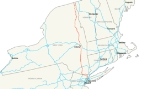
Interstate 87 is a 333.49 miles (536.7 km) Interstate Highway
located entirely within New York State in the United States of America. I-87 is the longest intrastate Interstate highway in the Interstate Highway System
. Its southern end is at the Bronx
approaches of the (Triboro) Robert F. Kennedy Bridge in New York City
. Its northern end is at the Canada – United States border in Champlain (town), New York
, where it continues into Quebec
as Autoroute 15
, which connects it to the City of Montreal
. I-87 connects with Interstate 95
in New York City
; New York State Route 17
(NY 17); future I-86
) near Harriman; Interstate 84
near Newburgh; and Interstate 90
in Albany
. The portion of I-87 between the New York City line and Albany is part of the New York State Thruway
. North of Albany, I-87 is nicknamed the Adirondack Northway.
(I-278
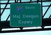
) at the Robert F. Kennedy Bridge. For the next 8.4 miles (13.5 km), Interstate 87 is named the Major William Francis Deegan
Expressway as it travels through The Bronx. The first exit along the Major Deegan northbound is for Willis Avenue and the nearby Third Avenue Bridge. There is an exit before this going southbound, for Brook Avenue. At 1.2 miles (1.93 km), Grand Concourse interchanges at Exit 3. East 149th Street is the next exit, which heads into the heart of The Bronx. Exit 5, which is signed for East 161st Street
, actually lets off at Jerome Avenue
, near Yankee Stadium
. Exit 6 is only accessible via Exit 5 (going northbound) and is for East 153rd Street. Exit 7 is for the Cross Bronx Expressway and Trans-Manhattan Expressway
, both of which are signed and maintained as I - 95 and U.S. Highway 1. Exit 8 is for West 179th Street, which becomes Burnside Avenue soon thereafter. Exit 9 runs parallel with Major Deegan for ending at West Fordham Road.
 U.S. Route 9 now runs parallel with Major Deegan, which is accessible via Exit 10 for West 230th Street. Interstate 87 next enters Van Cortlandt Park
and has an interchange with Van Cortlandt Park South at Exit 11. Exit 12 is for the Henry Hudson Parkway
and Saw Mill River Parkway
, both of which are accessible by the Mosholu Parkway
. Exit 13 is for East 233rd Street
and Jerome Avenue
. Exit 14 is at the northern end of Van Cortlandt Park, is for McLean Ave. The Major Deegan Expressway crosses into Westchester County at Yonkers and becomes the New York State Thruway
, a 496 miles (798 km), state-wide toll highway.
line and the junction with Interstate 90
at Albany is part of the New York State Thruway
. Interstate 87 enters Westchester at Yonkers. The first exit going northbound is for Hall Place, while going southbound it is for Hall Place and McLean Avenue. (McLean Avenue is Exit 14 going northbound on the Major Deegan. There is no southbound Exit 14.) The Yonkers Avenue interchange is at 9.8 miles (15.77 km). Present just off Exit 2 is Yonkers Raceway
. Exit 3 is for Mile Square Road, which interchanges just before the Cross County Shopping Center
. Exit 4 is for the Cross County Parkway
, which interchanges just after the shopping center. Exit 5 follows a frontage road, which heads for New York State Route 100
and the Sprain Brook Parkway
. Soon after, Tuckahoe Road interchanges just before leaving Yonkers. Exit 6A is for Stew Leonard Drive, which is just a road for Sprain Ridge Park.
.jpg) As Interstate 87 heads northward, New York State Route 9A
As Interstate 87 heads northward, New York State Route 9A
begins to run parallel with it, having an interchange at Exit 7. The Saw Mill River Parkway
also runs parallel, intersecting at Exit 7A. Before Exit 8, the Ardsley Service Area is accessible northbound. Exit 8 is for Interstate 287
, beginning a concurrency
for the next 19 miles (31 km). The exit is also the access for the Cross-Westchester Expressway. Exit 9 is the final exit before the Tappan Zee Bridge
. The exit is for New York State Route 119
and the nearby U.S. Highway 9. All trucks with Class A and Class B explosives must leave at Exit 9. Interstates 287 and 87 cross the Tappan Zee and enter Rockland County.
Interstate 87 begins a 25 miles (40 km) stretch in Rockland County. Exit 10 is the first exit after the Tappan Zee and is for U.S. Route 9W
in Nyack. Exit 11 is in downtown Nyack, for Highway 9W going northbound and New York State Route 59
going southbound. 87 then passes the Mountainview Nature County Park as it reaches Exit 12, which is located in the outskirts of Nyack. Exit 12 is a folded-diamond interchange for New York State Route 303
and the Palisades Center Mall. The first highway in 9.63 miles (15.5 km) interchanges at Exit 13, the Palisades Interstate Parkway
.
The road has three current spur routes: Interstate 287
connects with its parent in a 19-mile (31 km) long concurrency
near the southern end of the highway, with I - 87 signed as north - south, and I - 287 signed as east – west. This is a bypass
around New York City. West of the concurrency at Exit 15, it loops around New York to meet the New Jersey Turnpike
in Middlesex County, New Jersey
. East of the concurrency, I - 287 continues as the Cross Westchester Expressway to end at Interstate 95
(the New England Thruway
) in Rye, New York
, near the Connecticut
border. Note that I - 287 leaves New York state, while its parent does not, making I - 287 one of only a few three-digit Interstate Highways that goes through more states than does its parent. Moving north, Interstate 587 is less than two miles (3.2 km) long. It is unusual in that it has no interchanges along its length, and its eastern terminus is at a traffic light
, while its western terminus is at a roundabout
(where it connects with Interstate 87). Because there is no direct exit from I - 87 into Albany, the 15-kilometer-long Interstate 787
carries traffic to and from the Thruway and the capital city
.
 North of Albany, Interstate 87 is named the Adirondack Northway (or simply the "Northway"), and it continues all the way to the Canadian–American border at Champlain, New York. I - 87 joins the Northway at Exit 1. However, the Northway begins 0.86 miles (1.38 km) south of the interchange with I - 87 and I -90 at U.S. Highway 20 in Guilderland, NY. This short expressway spur, known locally as Fuller Road Alternate, is designated as NY 910F, an unsigned reference route, by the New York State Department of Transportation
.
Between Exit 1 (where I - 87 begins on the Northway) and Exit 22 (at Lake George, New York) I - 87 is a six-lane freeway with three lanes in each direction.
There is no Exit 3, since this number was reserved for an interchange with Interstate 687
, which has never been built. Planning is underway to relieve congestion at Exit 4 and provide better access to the Albany International Airport
. Several of the proposed alternatives add a new Exit 3.
Between Exits 2 and 5, I - 87 runs parallel to Wolf Road, a business thoroughfare through the town of Colonie
. The northbound exit ramp 2E ends at the intersection of New York Route 5 (Central Avenue) and Wolf Road. Wolf Road is east of the expressway to Exit 4 (County Route 151, Albany Shaker Road) southeast of the Albany International Airport. The remainder of Wolf Road runs along the west side of I - 87 from Albany Shaker Road to Watervliet Shaker Road a short distance to the west of Exit 5. Wolf Road serves as a main access point for Colonie Center
, one of the Capital District
's largest enclosed shopping malls, from I - 87.
The southern portion of the Northway through Colonie and Saratoga County is now a heavily-traveled commuter route. Since the highway's construction, Saratoga County has become the fastest growing area of the Capital District, and indeed all of upstate New York.
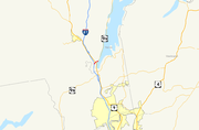
In Lake George
, I - 87 connects with U.S. Highway 9 and New York State Route 9N
at Exit 22 by way of a short two-lane highway known infrequently as the Lake George Connector. It is here where the first signs of Quebec Autoroute 15
are posted as motorists head north towards Canada. From here the Northway becomes four lanes all the way to the Canadian border (with the highway, both north and south slightly becoming six lanes once again just before the customs).
At milepost 100 on southbound I - 87, there is a United States Customs border patrol station. This was added after the 2001 terrorist attacks
.
In Clinton County, exit signs from Exit 34 to 43 are bilingual in English
and French
because of its proximity to Quebec
. Also, signs for Quebec Autoroute 15
are posted on I - 87 North as the Northway approaches the Canadian border.
. The highway initially utilized the pre-existing New York State Thruway
from Albany to Newburgh and in lower Westchester County, and the Major Deegan Expressway
in New York City. From Newburgh to the Elmsford area, I - 87 was to follow a new highway running parallel to U.S. Highway 9 northward along the eastern bank of the Hudson River
to Fishkill. I - 87 would then have followed the proposed I - 84 across the Hudson to rejoin the Thruway outside of Newburgh. Meanwhile, all of the Adirondack Northway, the portion of I - 87 slated to extend from Albany north to the Canadian–American border, had yet to be built.
 The Northway was built in segments, which became I - 87 as they were completed and linked to the pre-existing route. Construction began in the late 1950s on the portion of the Northway between the Thruway and New York State Route 7
near Latham. This segment was open to traffic by 1960, by which time work had begun on two additional segments from Latham to Malta (at New York State Route 67
) and from U.S. Highway 9 in northern Saratoga County to U.S. 9 and New York State Route 149
midway between Glens Falls and Lake George village. The expressway was completed between Latham and Clifton Park (New York State Route 146
) and from U.S. 9 south of Glens Falls to the Hudson River ca. 1961. Work on the Latham–Malta and US 9 – NY 149 segments concluded ca. 1962. Construction on the portion of highway between the two segments began about 1962 and was completed by 1964. During this same period, another extension brought the northern terminus of the Northway to New York State Route 9N south of Lake George village.
By 1966, the Northway was completed from Albany north to Lake George and from the Canadian border south to Keeseville
. At the time, I - 87 curved around the outskirts of Lake George to end at N.Y. 9N north of the village on a highway built ca. 1964. The last section of the Northway to be built—a 30 miles (48 km) stretch between Underwood (exit 30) and Keeseville (exit 34)—was completed in spring 1968. I - 87 was reconfigured slightly near Lake George as a result: instead of heading east to N.Y. 9N, it continued north on a parallel routing to U.S. 9. I - 87's former routing to N.Y. 9N, known infrequently today as the Lake George Connector, is now N.Y. 912Q, an unsigned reference route 0.66 miles (1.06 km) in length. N.Y. 912Q has one intermediate interchange with U.S. 9. The completion of I - 87 linked New York City with Montreal by way of a direct, limited-access highway (with I - 87 becoming Autoroute 15
at the Canadian border).
Parade Magazine designated the Northway as America's Most Scenic Highway in 1967. In 2007, the New York State Department of Transportation
(NYSDOT) ceremonially designated the entire 176 miles (283 km) Northway as the Adirondack Veterans' Memorial Highway.
A long stretch of the Northway through the Adirondack Park had been an unserved zone for cellular telephone service. In 2007, a driver crashed off the road was unable to summon help, prompting messages from local governments to telephone companies to add new wireless towers to address the problem, and also for warning signs to inform travelers of the so-called "dark zone". Throughout this area, roadside emergency call boxes are located approximately every two miles on both sides of the roadway. These boxes use a two-way UHF radio network to connect directly to New York State Police dispatchers. The first of 13 new cellular phone towers along I - 87 was installed in October 2008. A second cellular phone tower was completed just one month later.
Fuller Road Alternate, the lone portion of the Adirondack Northway not part of I - 87, was originally intended to be part of the Southern Albany Expressway, a proposed highway which would have connected the Northway with Interstate 787
and run parallel to the New York State Thruway
between Exits 23 and 24.
east to Purchase. From there, I - 87 headed north along the now-open expressway to Armonk, where it ended at New York State Route 22
. Another portion of the highway, from Goldens Bridge (New York State Route 138
) to Brewster, was open as well while the part from Armonk to Katonah was under construction. This segment, as well as the part from Katonah to Goldens Bridge, was completed by 1971.
On January 1, 1970, I - 87 was rerouted between Elmsford and Newburgh to follow the mainline of the Thruway instead. The former routing of I - 87 between Purchase and Brewster was then redesignated as Interstate 684
.
. Construction to convert the junction into a single-point urban interchange
began in mid-2008 and was completed on September 12, 2010. The total cost of the project was $41.9 million.
, either by constructing a new Exit 3, or by reconfiguring Exit 4. As of January 2010, the project is expected to be completed in late 2015.
and New York State Thruway for exits between New York City and Albany.
|-
|rowspan=8|Albany County
|Guilderland
|0.00
|
|
|At-grade intersection with a single lane flyover ramp serving eastbound to northbound traffic
|-
|rowspan=2|Albany
|0.49
|
|Crossgates Mall
Road
|Southbound exit and northbound entrance
|-
|0.86
0.00
|1E-W
|
|To New York State Thruway
; southbound I - 87 follows westbound I - 90
|-
|Village of Colonie
|1.39
|2W-E
|
|
|-
|rowspan=4|Town of Colonie
|3.30
|4
|
|Serves Albany International Airport
|-
|4.27
|5
|
|
|-
|5.53
|6
|
|NY 7 joins northbound and leaves southbound
|-
|6.12
|7
|
|NY 7 leaves northbound and joins southbound
|-
|rowspan=12|Saratoga County
|Halfmoon/Clifton Park
town line
|10.33
|8
|Crescent Road (CR 92) / Vischers Ferry Road (CR 90)
|CR 92 becomes CR 90 at the junction
|-
|rowspan="3"|Clifton Park
|11.76
|8A
|Grooms Road (CR 91)
|
|-
|13.30
|9
|
|Signed as exits 9W (west) and 9E (east) southbound
|-
|16.22
|10
|Ushers Road — Jonesville, Ballston Lake
|
|-
|Malta / Round Lake
town line
|18.79
|11
|Curry Avenue / Round Lake Road (CR 80)
|CR 80 terminates here, only Round Lake is designated as such
|-
|rowspan=2|Malta
|21.05
|12
|
|Roundabouts at tops of ramps replaced signals in 2006
|-
|24.81
|13N-S
|
|
|-
|rowspan=2|Saratoga Springs
|28.86
|14
|
|Parclo hybrid, Saratoga Race Course
|-
|rowspan=2|30.67
|rowspan=2|15
|rowspan=2|
|rowspan=2|
|-
|rowspan=2|Wilton
|-
|36.15
|16
|Ballard Road (CR 33) - Wilton
|
|-
|Moreau
|40.94
|17N-S
|
|
|-
|rowspan=10|Warren
|rowspan=3|Queensbury
|45.49
|18
|Glens Falls, Corinth
|
|-
|47.83
|19
|
|
|-
|50.11
|20
|
|
|-
|colspan=5 align="center"|Southern extent of Adirondack Park
|-
|rowspan=3|Town of Lake George
|53.31
|21
|
|
|-
|55.35
|22
|
|
|-
|59.79
|23
|Warrensburg and Diamond Point Road
|
|-
|Town of Warrensburg
|68.21
|24
|Bolton Landing and Riverbank Road
|
|-
|rowspan=2|Chester
|73.58
|25
|
|
|-
|78.12
|26
|
|
|-
|rowspan=7|Essex
|rowspan=2|Schroon
|82.36
|27
|
|
|-
|89.07
|28
|
|
|-
|rowspan=2|North Hudson
|95.01
|29
|Newcomb and Boreas Road/Blue Ridge Road
|
|-
|104.85
|30
|
|
|-
|Westport
|117.99
|31
|
|
|-
|Lewis
|123.75
|32
|Stowersville Road — Lewis, Willsboro
|
|-
|Chesterfield
|135.43
|33
|
|
|-
|rowspan=12|Clinton
|Au Sable
|139.22
|34
|
|
|-
|colspan=5 align="center"|Northern extent of Adirondack Park
|-
|Peru
|144.97
|35
|
|
|-
|rowspan=4|Town of Plattsburgh
|150.58
|36
| Plattsburgh International Airport
|
|-
|153.51
|37
|
|
|-
|155.31
|38S-N
|
|
|-
|156.87
|39
|
|Signed as exits 39N (north) and 39E (east) southbound
|-
|Beekmantown
|160.64
|40
|
|
|-
|Chazy
|168.26
|41
|
|
|-
|rowspan=3|Town of Champlain
|174.75
|42
|
|
|-
|176.02
|43
|
|
|-
|176.70
|colspan=4 align="center"|Canadian-American border. I - 87 continues north as Quebec Autoroute 15
Interstate Highway System
The Dwight D. Eisenhower National System of Interstate and Defense Highways, , is a network of limited-access roads including freeways, highways, and expressways forming part of the National Highway System of the United States of America...
located entirely within New York State in the United States of America. I-87 is the longest intrastate Interstate highway in the Interstate Highway System
Interstate Highway System
The Dwight D. Eisenhower National System of Interstate and Defense Highways, , is a network of limited-access roads including freeways, highways, and expressways forming part of the National Highway System of the United States of America...
. Its southern end is at the Bronx
The Bronx
The Bronx is the northernmost of the five boroughs of New York City. It is also known as Bronx County, the last of the 62 counties of New York State to be incorporated...
approaches of the (Triboro) Robert F. Kennedy Bridge in New York City
New York City
New York is the most populous city in the United States and the center of the New York Metropolitan Area, one of the most populous metropolitan areas in the world. New York exerts a significant impact upon global commerce, finance, media, art, fashion, research, technology, education, and...
. Its northern end is at the Canada – United States border in Champlain (town), New York
Champlain (town), New York
Champlain is a town in Clinton County, New York, United States. The population was 5,754 at the 2010 census. The town is named after Lake Champlain....
, where it continues into Quebec
Quebec
Quebec or is a province in east-central Canada. It is the only Canadian province with a predominantly French-speaking population and the only one whose sole official language is French at the provincial level....
as Autoroute 15
Quebec Autoroute 15
Autoroute 15 is a highway in western Quebec, Canada...
, which connects it to the City of Montreal
Montreal
Montreal is a city in Canada. It is the largest city in the province of Quebec, the second-largest city in Canada and the seventh largest in North America...
. I-87 connects with Interstate 95
Interstate 95
Interstate 95 is the main highway on the East Coast of the United States, running parallel to the Atlantic Ocean from Maine to Florida and serving some of the most populated urban areas in the country, including Boston, Providence, New Haven, New York City, Newark, Philadelphia, Baltimore,...
in New York City
New York City
New York is the most populous city in the United States and the center of the New York Metropolitan Area, one of the most populous metropolitan areas in the world. New York exerts a significant impact upon global commerce, finance, media, art, fashion, research, technology, education, and...
; New York State Route 17
New York State Route 17
New York State Route 17 is a state highway that extends for through the Southern Tier and Downstate regions of New York in the United States...
(NY 17); future I-86
Interstate 86 (east)
Interstate 86 is an Interstate Highway that extends for through northwestern Pennsylvania and southern New York in the United States...
) near Harriman; Interstate 84
Interstate 84 (east)
Interstate 84 is an Interstate Highway extending from Dunmore, Pennsylvania at an interchange with Interstate 81 to Sturbridge, Massachusetts, at an interchange with the Massachusetts Turnpike . I-84 has mile-log junction numbering in Pennsylvania; otherwise, exit numbers are roughly sequential...
near Newburgh; and Interstate 90
Interstate 90
Interstate 90 is the longest Interstate Highway in the United States at . It is the northernmost coast-to-coast interstate, and parallels US 20 for the most part. Its western terminus is in Seattle, at Edgar Martinez Drive S. near Safeco Field and CenturyLink Field, and its eastern terminus is in...
in Albany
Albany, New York
Albany is the capital city of the U.S. state of New York, the seat of Albany County, and the central city of New York's Capital District. Roughly north of New York City, Albany sits on the west bank of the Hudson River, about south of its confluence with the Mohawk River...
. The portion of I-87 between the New York City line and Albany is part of the New York State Thruway
New York State Thruway
The New York State Thruway is a system of limited-access highways located within the state of New York in the United States. The system, known officially as the Governor Thomas E. Dewey Thruway for former New York Governor Thomas E. Dewey, is operated by the New York State Thruway Authority and...
. North of Albany, I-87 is nicknamed the Adirondack Northway.
Major Deegan Expressway
Interstate 87 begins at an intersection with the Bruckner ExpresswayBruckner Expressway
The Bruckner Expressway is a freeway in The Bronx. It carries Interstate 278 and Interstate 95 from the Robert F. Kennedy Bridge to the south end of the New England Thruway at the Pelham Parkway interchange....
(I-278
Interstate 278
Interstate 278 is an auxiliary Interstate Highway in New Jersey and New York, United States. The road runs from U.S. Route 1/9 in Linden, New Jersey to the Bruckner Interchange in the New York City borough of the Bronx...
) at the Robert F. Kennedy Bridge. For the next 8.4 miles (13.5 km), Interstate 87 is named the Major William Francis Deegan
William Francis Deegan
William Francis Deegan was an architect, Major in the Army Corps of Engineers, and Democratic political leader in New York City.-Biography:He was born on December 28, 1882to Irish immigrants...
Expressway as it travels through The Bronx. The first exit along the Major Deegan northbound is for Willis Avenue and the nearby Third Avenue Bridge. There is an exit before this going southbound, for Brook Avenue. At 1.2 miles (1.93 km), Grand Concourse interchanges at Exit 3. East 149th Street is the next exit, which heads into the heart of The Bronx. Exit 5, which is signed for East 161st Street
East 161st Street (Bronx)
East 161st Street is a short, major thoroughfare in the southern portion of the Bronx. The road is 1.6 mile long and is the best access to the Yankee Stadium. The road begins at an intersection with Jerome Avenue, a major thoroughfare in the Bronx, and Woodycrest Avenue, a one-way street in the...
, actually lets off at Jerome Avenue
Jerome Avenue
Jerome Avenue is one of the longest thoroughfares in the New York City borough of the Bronx, New York, United States. The road is 5.6 miles long and stretches from Highbridge general area to Woodlawn. Both of these termini are with the Major Deegan Expressway which runs parallel to the west. Most...
, near Yankee Stadium
Yankee Stadium
Yankee Stadium was a stadium located in The Bronx in New York City, New York. It was the home ballpark of the New York Yankees from 1923 to 1973 and from 1976 to 2008. The stadium hosted 6,581 Yankees regular season home games during its 85-year history. It was also the former home of the New York...
. Exit 6 is only accessible via Exit 5 (going northbound) and is for East 153rd Street. Exit 7 is for the Cross Bronx Expressway and Trans-Manhattan Expressway
Trans-Manhattan Expressway
The Trans-Manhattan Expressway or George Washington Bridge Expressway is a highway in New York City that is part of the Interstate Highway System. Though few of the millions who use it or live near it have ever heard the name, it is probably one of the shortest, busiest, and most congested named...
, both of which are signed and maintained as I - 95 and U.S. Highway 1. Exit 8 is for West 179th Street, which becomes Burnside Avenue soon thereafter. Exit 9 runs parallel with Major Deegan for ending at West Fordham Road.
Van Cortlandt Park
Van Cortlandt Park is a park located in the Bronx in New York City. It is the fourth largest park in New York City, behind Pelham Bay Park, Flushing Meadows Park and Staten Island Greenbelt....
and has an interchange with Van Cortlandt Park South at Exit 11. Exit 12 is for the Henry Hudson Parkway
Henry Hudson Parkway
The Henry Hudson Parkway is an long parkway in New York City. The southern terminus is at West 72nd Street in Manhattan, where the parkway continues south as the West Side Highway. It is often erroneously referred to as the West Side Highway throughout its entire course in Manhattan...
and Saw Mill River Parkway
Saw Mill River Parkway
The Saw Mill River Parkway is a north–south parkway that extends for through Westchester County, New York, in the United States. It begins at the border between Westchester County and the Bronx, where it continues into New York City as the Henry Hudson Parkway, and heads generally...
, both of which are accessible by the Mosholu Parkway
Mosholu Parkway
The Mosholu Parkway is a hybrid freeway-standard parkway and grade-level roadway in the New York City borough of the Bronx, constructed from 1935 to 1937 as part of the roadway network created under Robert Moses...
. Exit 13 is for East 233rd Street
East 233rd Street (Bronx)
East 233rd Street is one of the major thoroughfares of the Bronx. The road is 3 miles long and stretches from U.S. Route 1 in the Eastchester section of the Bronx to the Major Deegan Expressway in Woodlawn . The road changes names from East 233rd Street to Pinkley Avenue after the...
and Jerome Avenue
Jerome Avenue
Jerome Avenue is one of the longest thoroughfares in the New York City borough of the Bronx, New York, United States. The road is 5.6 miles long and stretches from Highbridge general area to Woodlawn. Both of these termini are with the Major Deegan Expressway which runs parallel to the west. Most...
. Exit 14 is at the northern end of Van Cortlandt Park, is for McLean Ave. The Major Deegan Expressway crosses into Westchester County at Yonkers and becomes the New York State Thruway
New York State Thruway
The New York State Thruway is a system of limited-access highways located within the state of New York in the United States. The system, known officially as the Governor Thomas E. Dewey Thruway for former New York Governor Thomas E. Dewey, is operated by the New York State Thruway Authority and...
, a 496 miles (798 km), state-wide toll highway.
New York State Thruway
The section of highway between the New York CityNew York City
New York is the most populous city in the United States and the center of the New York Metropolitan Area, one of the most populous metropolitan areas in the world. New York exerts a significant impact upon global commerce, finance, media, art, fashion, research, technology, education, and...
line and the junction with Interstate 90
Interstate 90
Interstate 90 is the longest Interstate Highway in the United States at . It is the northernmost coast-to-coast interstate, and parallels US 20 for the most part. Its western terminus is in Seattle, at Edgar Martinez Drive S. near Safeco Field and CenturyLink Field, and its eastern terminus is in...
at Albany is part of the New York State Thruway
New York State Thruway
The New York State Thruway is a system of limited-access highways located within the state of New York in the United States. The system, known officially as the Governor Thomas E. Dewey Thruway for former New York Governor Thomas E. Dewey, is operated by the New York State Thruway Authority and...
. Interstate 87 enters Westchester at Yonkers. The first exit going northbound is for Hall Place, while going southbound it is for Hall Place and McLean Avenue. (McLean Avenue is Exit 14 going northbound on the Major Deegan. There is no southbound Exit 14.) The Yonkers Avenue interchange is at 9.8 miles (15.77 km). Present just off Exit 2 is Yonkers Raceway
Yonkers Raceway
Yonkers Raceway, founded in 1899 as the Empire City Race Track, is a one-half-mile standardbred harness racing dirt track and New York state-approved slots racino located at the intersection of Central Park Avenue and Yonkers Avenue in Yonkers, New York near the New York City border...
. Exit 3 is for Mile Square Road, which interchanges just before the Cross County Shopping Center
Cross County Shopping Center
Cross County Shopping Center, also known as Cross County Center is an open-air shopping mall located in Yonkers, New York, United States. Over 100 stores and restaurants are featured in the mall, including anchor stores Macy's, Old Navy and Sears. The mall is managed by Macerich.-History:Cross...
. Exit 4 is for the Cross County Parkway
Cross County Parkway
The Cross County Parkway is a long parkway in Westchester County, New York. The parkway is a critical east–west connection throughout Westchester, having full interchanges with every major north–south parkway in southern Westchester, in addition to the New York State Thruway mainline....
, which interchanges just after the shopping center. Exit 5 follows a frontage road, which heads for New York State Route 100
New York State Route 100
New York State Route 100 is a major north–south state highway in Westchester County, New York, in the United States. It begins parallel to Interstate 87 at a junction with the Cross County Parkway in the city of Yonkers and runs through most of the length of the county via the city of...
and the Sprain Brook Parkway
Sprain Brook Parkway
The Sprain Brook Parkway is a long north–south parkway in Westchester County, New York. It is one of the newest and most modern parkways in Westchester County, adopting many ideas and improvements developed during decades of statewide highway construction. The southern terminus is at the...
. Soon after, Tuckahoe Road interchanges just before leaving Yonkers. Exit 6A is for Stew Leonard Drive, which is just a road for Sprain Ridge Park.
New York State Route 9A
New York State Route 9A is a state highway in the vicinity of New York City, New York, United States. Its southern terminus is at the northern end of the Brooklyn–Battery Tunnel in New York City, where it intersects with both Interstate 478 and FDR Drive. The northern terminus of...
begins to run parallel with it, having an interchange at Exit 7. The Saw Mill River Parkway
Saw Mill River Parkway
The Saw Mill River Parkway is a north–south parkway that extends for through Westchester County, New York, in the United States. It begins at the border between Westchester County and the Bronx, where it continues into New York City as the Henry Hudson Parkway, and heads generally...
also runs parallel, intersecting at Exit 7A. Before Exit 8, the Ardsley Service Area is accessible northbound. Exit 8 is for Interstate 287
Interstate 287
Interstate 287 is an auxiliary Interstate Highway in the U.S. states of New Jersey and New York. It is a partial beltway around New York City, serving the northern half of New Jersey and the counties of Rockland and Westchester in New York...
, beginning a concurrency
Concurrency (road)
A concurrency, overlap, or coincidence in a road network is an instance of one physical road bearing two or more different highway, motorway, or other route numbers...
for the next 19 miles (31 km). The exit is also the access for the Cross-Westchester Expressway. Exit 9 is the final exit before the Tappan Zee Bridge
Tappan Zee Bridge
The Governor Malcolm Wilson Tappan Zee Bridge, usually referred to as Tappan Zee Bridge, is a cantilever bridge in New York over the Hudson River at one of its widest points; the Tappan Zee is named for an American Indian tribe from the area called "Tappan"; and zee being the Dutch word for "sea"....
. The exit is for New York State Route 119
New York State Route 119
New York State Route 119 is an east–west state highway in Westchester County, New York, in the United States. The road starts in Tarrytown at an intersection with U.S. Route 9 and comes to an end at a junction with NY 22 in White Plains...
and the nearby U.S. Highway 9. All trucks with Class A and Class B explosives must leave at Exit 9. Interstates 287 and 87 cross the Tappan Zee and enter Rockland County.
Interstate 87 begins a 25 miles (40 km) stretch in Rockland County. Exit 10 is the first exit after the Tappan Zee and is for U.S. Route 9W
U.S. Route 9W
U.S. Route 9W is a north–south U.S. Highway in the states of New Jersey and New York. It begins on Fletcher Avenue in Fort Lee, New Jersey as it crosses the US 1 & 9, US 46, and the Interstate 95 approaches to the George Washington Bridge, where it heads north up the west...
in Nyack. Exit 11 is in downtown Nyack, for Highway 9W going northbound and New York State Route 59
New York State Route 59
New York State Route 59 is an east–west state highway in southern Rockland County, New York, in the United States. The route extends for from NY 17 in Hillburn to U.S. Route 9W in Nyack. In Suffern, it has a concurrency with US 202 for . NY 59 runs parallel to the New...
going southbound. 87 then passes the Mountainview Nature County Park as it reaches Exit 12, which is located in the outskirts of Nyack. Exit 12 is a folded-diamond interchange for New York State Route 303
New York State Route 303
New York State Route 303 is a north–south state highway in eastern Rockland County, New York, in the United States. It begins at the New Jersey state line in the hamlet of Tappan and ends later at an intersection with U.S. Route 9W in Clarkstown...
and the Palisades Center Mall. The first highway in 9.63 miles (15.5 km) interchanges at Exit 13, the Palisades Interstate Parkway
Palisades Interstate Parkway
The Palisades Interstate Parkway is a long limited-access highway in the U.S. states of New Jersey and New York. The parkway is a major commuter route into New York City from Rockland and Orange counties in New York and Bergen County in New Jersey...
.
The road has three current spur routes: Interstate 287
Interstate 287
Interstate 287 is an auxiliary Interstate Highway in the U.S. states of New Jersey and New York. It is a partial beltway around New York City, serving the northern half of New Jersey and the counties of Rockland and Westchester in New York...
connects with its parent in a 19-mile (31 km) long concurrency
Concurrency (road)
A concurrency, overlap, or coincidence in a road network is an instance of one physical road bearing two or more different highway, motorway, or other route numbers...
near the southern end of the highway, with I - 87 signed as north - south, and I - 287 signed as east – west. This is a bypass
Bypass
Bypass may refer to:* Bypass , in effects units, a switch that allows sound* Bypass , in computing, circumventing security features in hacking, or taking a different approach to an issue in troubleshooting* Bypass * Bypass surgery...
around New York City. West of the concurrency at Exit 15, it loops around New York to meet the New Jersey Turnpike
New Jersey Turnpike
The New Jersey Turnpike is a toll road in New Jersey, maintained by the New Jersey Turnpike Authority. According to the International Bridge, Tunnel and Turnpike Association, the Turnpike is the nation's sixth-busiest toll road and is among one of the most heavily traveled highways in the United...
in Middlesex County, New Jersey
Middlesex County, New Jersey
-Demographics:As of the census of 2000, there were 750,162 people, 265,815 households, and 190,855 families residing in the county. The population density was 2,422 people per square mile . There were 273,637 housing units at an average density of 884 per square mile...
. East of the concurrency, I - 287 continues as the Cross Westchester Expressway to end at Interstate 95
Interstate 95
Interstate 95 is the main highway on the East Coast of the United States, running parallel to the Atlantic Ocean from Maine to Florida and serving some of the most populated urban areas in the country, including Boston, Providence, New Haven, New York City, Newark, Philadelphia, Baltimore,...
(the New England Thruway
New England Thruway
The New England Thruway is a portion of the U.S. Interstate highway system and of the New York State Thruway, within and operated by the New York State Thruway Authority, linking New York City with New England, specifically with southwestern Connecticut...
) in Rye, New York
Rye (city), New York
Rye is a city in Westchester County, New York, United States. It is separate from the town of Rye, which is larger than the city. Rye city, formerly the village of Rye, was part of the town until 1942, when it received its charter as a city, the most recent to be issued in New York...
, near the Connecticut
Connecticut
Connecticut is a state in the New England region of the northeastern United States. It is bordered by Rhode Island to the east, Massachusetts to the north, and the state of New York to the west and the south .Connecticut is named for the Connecticut River, the major U.S. river that approximately...
border. Note that I - 287 leaves New York state, while its parent does not, making I - 287 one of only a few three-digit Interstate Highways that goes through more states than does its parent. Moving north, Interstate 587 is less than two miles (3.2 km) long. It is unusual in that it has no interchanges along its length, and its eastern terminus is at a traffic light
Traffic light
Traffic lights, which may also be known as stoplights, traffic lamps, traffic signals, signal lights, robots or semaphore, are signalling devices positioned at road intersections, pedestrian crossings and other locations to control competing flows of traffic...
, while its western terminus is at a roundabout
Roundabout
A roundabout is the name for a road junction in which traffic moves in one direction around a central island. The word dates from the early 20th century. Roundabouts are common in many countries around the world...
(where it connects with Interstate 87). Because there is no direct exit from I - 87 into Albany, the 15-kilometer-long Interstate 787
Interstate 787
Interstate 787 is an auxiliary Interstate Highway in the U.S. state of New York. I-787 is the main highway for those traveling into and out of downtown Albany. The southern terminus is at the Interstate 87/New York State Thruway exit 23 toll plaza southwest of downtown Albany...
carries traffic to and from the Thruway and the capital city
Capital City
Capital City was a television show produced by Euston Films which focused on the lives of investment bankers in London living and working on the corporate trading floor for the fictional international bank Shane-Longman....
.
Adirondack Northway
New York State Department of Transportation
The New York State Department of Transportation is responsible for the development and operation of highways, railroads, mass transit systems, ports, waterways and aviation facilities in the U.S...
.
Between Exit 1 (where I - 87 begins on the Northway) and Exit 22 (at Lake George, New York) I - 87 is a six-lane freeway with three lanes in each direction.
There is no Exit 3, since this number was reserved for an interchange with Interstate 687
Interstate 687
Interstate 687 was a proposed auxiliary Interstate Highway in the Capital District region of New York in the United States. The highway would have connected I-90 in Albany to I-87 near Albany International Airport in Colonie...
, which has never been built. Planning is underway to relieve congestion at Exit 4 and provide better access to the Albany International Airport
Albany International Airport
Albany International Airport is a public use airport located six nautical miles northwest of the central business district of Albany, in Albany County, New York, United States. It is owned by the Albany County Airport Authority....
. Several of the proposed alternatives add a new Exit 3.
Between Exits 2 and 5, I - 87 runs parallel to Wolf Road, a business thoroughfare through the town of Colonie
Colonie (town), New York
Colonie is a town in Albany County, New York, United States. It is the most populous suburb of Albany, New York, and is the third largest town in area in Albany County, occupying about 11% of the county. Several hamlets exist within the town. As of the 2010 census, the town had a total population...
. The northbound exit ramp 2E ends at the intersection of New York Route 5 (Central Avenue) and Wolf Road. Wolf Road is east of the expressway to Exit 4 (County Route 151, Albany Shaker Road) southeast of the Albany International Airport. The remainder of Wolf Road runs along the west side of I - 87 from Albany Shaker Road to Watervliet Shaker Road a short distance to the west of Exit 5. Wolf Road serves as a main access point for Colonie Center
Colonie Center
Colonie Center is a shopping mall located in Albany at the intersection of Central Avenue, Wolf Road, and Interstate 87. Opening in 1966, it was the first enclosed shopping mall in New York State's Capital Region. The mall has successfully updated its tenant mix, image, and look on an ongoing basis...
, one of the Capital District
Capital District
New York's Capital District, also known as the Capital Region, is a region in upstate New York that generally refers to the four counties surrounding Albany, the capital of the state: Albany County, Schenectady County, Rensselaer County, and Saratoga County...
's largest enclosed shopping malls, from I - 87.
The southern portion of the Northway through Colonie and Saratoga County is now a heavily-traveled commuter route. Since the highway's construction, Saratoga County has become the fastest growing area of the Capital District, and indeed all of upstate New York.
In Lake George
Lake George (village), New York
The Village of Lake George is a village within the town of Lake George in Warren County, New York, United States. The population was 985 at the 2000 census. It is part of the Glens Falls Metropolitan Statistical Area...
, I - 87 connects with U.S. Highway 9 and New York State Route 9N
New York State Route 9N
New York State Route 9N is a north–south state highway in northeastern New York, United States. It extends from an intersection with U.S. Route 9 , NY 29, and NY 50 in the city of Saratoga Springs to a junction with US 9 and NY 22 in the Clinton County village of...
at Exit 22 by way of a short two-lane highway known infrequently as the Lake George Connector. It is here where the first signs of Quebec Autoroute 15
Quebec Autoroute 15
Autoroute 15 is a highway in western Quebec, Canada...
are posted as motorists head north towards Canada. From here the Northway becomes four lanes all the way to the Canadian border (with the highway, both north and south slightly becoming six lanes once again just before the customs).
At milepost 100 on southbound I - 87, there is a United States Customs border patrol station. This was added after the 2001 terrorist attacks
September 11, 2001 attacks
The September 11 attacks The September 11 attacks The September 11 attacks (also referred to as September 11, September 11th or 9/119/11 is pronounced "nine eleven". The slash is not part of the pronunciation...
.
In Clinton County, exit signs from Exit 34 to 43 are bilingual in English
English language
English is a West Germanic language that arose in the Anglo-Saxon kingdoms of England and spread into what was to become south-east Scotland under the influence of the Anglian medieval kingdom of Northumbria...
and French
French language
French is a Romance language spoken as a first language in France, the Romandy region in Switzerland, Wallonia and Brussels in Belgium, Monaco, the regions of Quebec and Acadia in Canada, and by various communities elsewhere. Second-language speakers of French are distributed throughout many parts...
because of its proximity to Quebec
Quebec
Quebec or is a province in east-central Canada. It is the only Canadian province with a predominantly French-speaking population and the only one whose sole official language is French at the provincial level....
. Also, signs for Quebec Autoroute 15
Quebec Autoroute 15
Autoroute 15 is a highway in western Quebec, Canada...
are posted on I - 87 North as the Northway approaches the Canadian border.
History
The designation Interstate 87 was assigned on August 14, 1957, as part of the establishment of the Interstate Highway SystemInterstate Highway System
The Dwight D. Eisenhower National System of Interstate and Defense Highways, , is a network of limited-access roads including freeways, highways, and expressways forming part of the National Highway System of the United States of America...
. The highway initially utilized the pre-existing New York State Thruway
New York State Thruway
The New York State Thruway is a system of limited-access highways located within the state of New York in the United States. The system, known officially as the Governor Thomas E. Dewey Thruway for former New York Governor Thomas E. Dewey, is operated by the New York State Thruway Authority and...
from Albany to Newburgh and in lower Westchester County, and the Major Deegan Expressway
Major Deegan Expressway
The Major Deegan Expressway is a north–south expressway in the New York City borough of the Bronx...
in New York City. From Newburgh to the Elmsford area, I - 87 was to follow a new highway running parallel to U.S. Highway 9 northward along the eastern bank of the Hudson River
Hudson River
The Hudson is a river that flows from north to south through eastern New York. The highest official source is at Lake Tear of the Clouds, on the slopes of Mount Marcy in the Adirondack Mountains. The river itself officially begins in Henderson Lake in Newcomb, New York...
to Fishkill. I - 87 would then have followed the proposed I - 84 across the Hudson to rejoin the Thruway outside of Newburgh. Meanwhile, all of the Adirondack Northway, the portion of I - 87 slated to extend from Albany north to the Canadian–American border, had yet to be built.
Adirondack Northway
New York State Route 7
New York State Route 7 is a 180-mile long New York State Highway that runs from the New York/Pennsylvania border south of Binghamton, New York to the New York/Vermont border east of Hoosick. Most of the road runs along the Susquehanna Valley, closely paralleling Interstate 88 throughout...
near Latham. This segment was open to traffic by 1960, by which time work had begun on two additional segments from Latham to Malta (at New York State Route 67
New York State Route 67
New York State Route 67 is an east–west state highway in eastern New York in the United States. The western terminus of the route is at an intersection with NY 5 in the town of St. Johnsville...
) and from U.S. Highway 9 in northern Saratoga County to U.S. 9 and New York State Route 149
New York State Route 149
New York State Route 149 is an east–west state highway that runs for through the Capital District of New York in the United States. It begins at exit 20 on the Adirondack Northway in the Warren County town of Queensbury and intersects U.S...
midway between Glens Falls and Lake George village. The expressway was completed between Latham and Clifton Park (New York State Route 146
New York State Route 146
New York State Route 146 is a state highway in the Capital District of New York in the United States. It extends for from Gallupville at NY 443 to near Mechanicville at U.S. Route 4 and NY 32. NY 146 is a major thoroughfare in the city of Schenectady, just outside of...
) and from U.S. 9 south of Glens Falls to the Hudson River ca. 1961. Work on the Latham–Malta and US 9 – NY 149 segments concluded ca. 1962. Construction on the portion of highway between the two segments began about 1962 and was completed by 1964. During this same period, another extension brought the northern terminus of the Northway to New York State Route 9N south of Lake George village.
By 1966, the Northway was completed from Albany north to Lake George and from the Canadian border south to Keeseville
Keeseville, New York
Keeseville is a village in both Clinton County, New York and in Essex County, New York in the United States. The population was 1,815 at the 2010 census. The village is named after the Keese family....
. At the time, I - 87 curved around the outskirts of Lake George to end at N.Y. 9N north of the village on a highway built ca. 1964. The last section of the Northway to be built—a 30 miles (48 km) stretch between Underwood (exit 30) and Keeseville (exit 34)—was completed in spring 1968. I - 87 was reconfigured slightly near Lake George as a result: instead of heading east to N.Y. 9N, it continued north on a parallel routing to U.S. 9. I - 87's former routing to N.Y. 9N, known infrequently today as the Lake George Connector, is now N.Y. 912Q, an unsigned reference route 0.66 miles (1.06 km) in length. N.Y. 912Q has one intermediate interchange with U.S. 9. The completion of I - 87 linked New York City with Montreal by way of a direct, limited-access highway (with I - 87 becoming Autoroute 15
Quebec Autoroute 15
Autoroute 15 is a highway in western Quebec, Canada...
at the Canadian border).
Parade Magazine designated the Northway as America's Most Scenic Highway in 1967. In 2007, the New York State Department of Transportation
New York State Department of Transportation
The New York State Department of Transportation is responsible for the development and operation of highways, railroads, mass transit systems, ports, waterways and aviation facilities in the U.S...
(NYSDOT) ceremonially designated the entire 176 miles (283 km) Northway as the Adirondack Veterans' Memorial Highway.
A long stretch of the Northway through the Adirondack Park had been an unserved zone for cellular telephone service. In 2007, a driver crashed off the road was unable to summon help, prompting messages from local governments to telephone companies to add new wireless towers to address the problem, and also for warning signs to inform travelers of the so-called "dark zone". Throughout this area, roadside emergency call boxes are located approximately every two miles on both sides of the roadway. These boxes use a two-way UHF radio network to connect directly to New York State Police dispatchers. The first of 13 new cellular phone towers along I - 87 was installed in October 2008. A second cellular phone tower was completed just one month later.
Fuller Road Alternate, the lone portion of the Adirondack Northway not part of I - 87, was originally intended to be part of the Southern Albany Expressway, a proposed highway which would have connected the Northway with Interstate 787
Interstate 787
Interstate 787 is an auxiliary Interstate Highway in the U.S. state of New York. I-787 is the main highway for those traveling into and out of downtown Albany. The southern terminus is at the Interstate 87/New York State Thruway exit 23 toll plaza southwest of downtown Albany...
and run parallel to the New York State Thruway
New York State Thruway
The New York State Thruway is a system of limited-access highways located within the state of New York in the United States. The system, known officially as the Governor Thomas E. Dewey Thruway for former New York Governor Thomas E. Dewey, is operated by the New York State Thruway Authority and...
between Exits 23 and 24.
Lower Hudson Valley
By 1962, the plan to build I - 87 along the proposed Hudson River Expressway had been scrapped. Instead, I - 87 was then proposed to begin in Port Chester and follow a new routing through Purchase, Armonk, and Katonah to Brewster, where it would join I - 84. The routing was modified slightly by 1968: I - 87 still began in New York City, then overlapped with Interstate 287Interstate 287
Interstate 287 is an auxiliary Interstate Highway in the U.S. states of New Jersey and New York. It is a partial beltway around New York City, serving the northern half of New Jersey and the counties of Rockland and Westchester in New York...
east to Purchase. From there, I - 87 headed north along the now-open expressway to Armonk, where it ended at New York State Route 22
New York State Route 22
New York State Route 22 is a north–south state highway in eastern New York in the United States. It runs parallel to the state's eastern edge from the outskirts of New York City to a short distance south of the Canadian border. At , it is the state's longest north–south route and...
. Another portion of the highway, from Goldens Bridge (New York State Route 138
New York State Route 138
New York State Route 138 is a long state highway in Westchester County, New York. It begins in the town of Somers at NY 100 and ends at NY 121 west of the hamlet of Waccabuc. The road passes by the shopping center at Golden's Bridge.-Route description:NY 138 begins at...
) to Brewster, was open as well while the part from Armonk to Katonah was under construction. This segment, as well as the part from Katonah to Goldens Bridge, was completed by 1971.
On January 1, 1970, I - 87 was rerouted between Elmsford and Newburgh to follow the mainline of the Thruway instead. The former routing of I - 87 between Purchase and Brewster was then redesignated as Interstate 684
Interstate 684
Interstate 684 is a 28.4 mile-long north–south Interstate Highway in the states of New York and Connecticut. The highway connects I-84 with I-287 and the Hutchinson River Parkway, primarily serving commuter traffic to and from the northern suburbs of the New York metropolitan area...
.
Other developments
Exit 6 on the Adirondack Northway was originally a diamond interchangeDiamond interchange
A diamond interchange is a common type of road junction, used where a freeway crosses a minor road. The freeway itself is grade-separated from the minor road, one crossing the other over a bridge...
. Construction to convert the junction into a single-point urban interchange
Single-point urban interchange
A single-point urban interchange , also called a single-point interchange or single-point diamond interchange , is a type of highway interchange...
began in mid-2008 and was completed on September 12, 2010. The total cost of the project was $41.9 million.
Future
A project is in the early stages of design to improve access to the Albany International AirportAlbany International Airport
Albany International Airport is a public use airport located six nautical miles northwest of the central business district of Albany, in Albany County, New York, United States. It is owned by the Albany County Airport Authority....
, either by constructing a new Exit 3, or by reconfiguring Exit 4. As of January 2010, the project is expected to be completed in late 2015.
South of Albany
See Major Deegan Expressway for exits in New York CityNew York City
New York is the most populous city in the United States and the center of the New York Metropolitan Area, one of the most populous metropolitan areas in the world. New York exerts a significant impact upon global commerce, finance, media, art, fashion, research, technology, education, and...
and New York State Thruway for exits between New York City and Albany.
Northway
This exit list includes the segment of the Northway designated as NY 910F. Note that mile markers begin from where I - 87 leaves the Thruway, and not the mileage from the highway's beginning in New York City.|-
|rowspan=8|Albany County
|Guilderland
|0.00
|
|
|At-grade intersection with a single lane flyover ramp serving eastbound to northbound traffic
|-
|rowspan=2|Albany
|0.49
|
|Crossgates Mall
Crossgates Mall
Crossgates Mall is a shopping mall located in Albany, New York, United States, not far from Schenectady. The mall opened on March 4, 1984, and in October 1994 underwent a large expansion that nearly doubled its size. It now has a gross leasable area of with two floors including 250 shops and...
Road
|Southbound exit and northbound entrance
|-
|0.86
0.00
|1E-W
|
|To New York State Thruway
New York State Thruway
The New York State Thruway is a system of limited-access highways located within the state of New York in the United States. The system, known officially as the Governor Thomas E. Dewey Thruway for former New York Governor Thomas E. Dewey, is operated by the New York State Thruway Authority and...
; southbound I - 87 follows westbound I - 90
|-
|Village of Colonie
Colonie (village), New York
Colonie is a village in Albany County, New York, USA. The population was 7,793 at the 2010 census.The village of Colonie is within the town of Colonie...
|1.39
|2W-E
|
|
|-
|rowspan=4|Town of Colonie
Colonie (town), New York
Colonie is a town in Albany County, New York, United States. It is the most populous suburb of Albany, New York, and is the third largest town in area in Albany County, occupying about 11% of the county. Several hamlets exist within the town. As of the 2010 census, the town had a total population...
|3.30
|4
|
|Serves Albany International Airport
Albany International Airport
Albany International Airport is a public use airport located six nautical miles northwest of the central business district of Albany, in Albany County, New York, United States. It is owned by the Albany County Airport Authority....
|-
|4.27
|5
|
|
|-
|5.53
|6
|
|NY 7 joins northbound and leaves southbound
|-
|6.12
|7
|
|NY 7 leaves northbound and joins southbound
|-
|rowspan=12|Saratoga County
|Halfmoon/Clifton Park
town line
|10.33
|8
|Crescent Road (CR 92) / Vischers Ferry Road (CR 90)
|CR 92 becomes CR 90 at the junction
|-
|rowspan="3"|Clifton Park
|11.76
|8A
|Grooms Road (CR 91)
|
|-
|13.30
|9
|
|Signed as exits 9W (west) and 9E (east) southbound
|-
|16.22
|10
|Ushers Road — Jonesville, Ballston Lake
|
|-
|Malta / Round Lake
town line
|18.79
|11
|Curry Avenue / Round Lake Road (CR 80)
|CR 80 terminates here, only Round Lake is designated as such
|-
|rowspan=2|Malta
|21.05
|12
|
|Roundabouts at tops of ramps replaced signals in 2006
|-
|24.81
|13N-S
|
|
|-
|rowspan=2|Saratoga Springs
|28.86
|14
|
|Parclo hybrid, Saratoga Race Course
|-
|rowspan=2|30.67
|rowspan=2|15
|rowspan=2|
|rowspan=2|
|-
|rowspan=2|Wilton
|-
|36.15
|16
|Ballard Road (CR 33) - Wilton
|
|-
|Moreau
|40.94
|17N-S
|
|
|-
|rowspan=10|Warren
|rowspan=3|Queensbury
|45.49
|18
|Glens Falls, Corinth
|
|-
|47.83
|19
|
|
|-
|50.11
|20
|
|
|-
|colspan=5 align="center"|Southern extent of Adirondack Park
|-
|rowspan=3|Town of Lake George
|53.31
|21
|
|
|-
|55.35
|22
|
|
|-
|59.79
|23
|Warrensburg and Diamond Point Road
|
|-
|Town of Warrensburg
|68.21
|24
|Bolton Landing and Riverbank Road
|
|-
|rowspan=2|Chester
Chester, Warren County, New York
----Chester is a town in Warren County, New York, United States. It is part of the Glens Falls Metropolitan Statistical Area. The population was 3,614 at the 2000 census...
|73.58
|25
|
|
|-
|78.12
|26
|
|
|-
|rowspan=7|Essex
|rowspan=2|Schroon
|82.36
|27
|
|
|-
|89.07
|28
|
|
|-
|rowspan=2|North Hudson
|95.01
|29
|Newcomb and Boreas Road/Blue Ridge Road
|
|-
|104.85
|30
|
|
|-
|Westport
|117.99
|31
|
|
|-
|Lewis
Lewis, Essex County, New York
----Lewis is a town in Essex County, New York, United States. The population was 1,200 at the 2000 census. The town is named after Morgan Lewis, the governor of New York at the time the town was established....
|123.75
|32
|Stowersville Road — Lewis, Willsboro
|
|-
|Chesterfield
|135.43
|33
|
|
|-
|rowspan=12|Clinton
|Au Sable
Au Sable, New York
Au Sable, or Ausable, is a town in Clinton County, New York, United States. The population was 3,146 at the 2010 census. The name is from a river that flows through the town and means "Of the sand."...
|139.22
|34
|
|
|-
|colspan=5 align="center"|Northern extent of Adirondack Park
|-
|Peru
Peru, New York
Peru is a town in Clinton County in the U.S. state of New York. The population was 6,998 at the 2010 census. The town was named Peru because its mountainous nature suggested that country....
|144.97
|35
|
|
|-
|rowspan=4|Town of Plattsburgh
Plattsburgh (town), New York
Plattsburgh is a town in Clinton County, New York, United States. The population was 11,870 at the 2010 census. The town is named after Zephaniah Platt, an early land owner.The Town of Plattsburgh borders the City of Plattsburgh...
|150.58
|36
| Plattsburgh International Airport
Plattsburgh International Airport
-Top Destinations:-References:Other sources:*. Press-Republican, 2005-07-13.*. Press-Republican, 2007-05-30.*. Press-Republican, 2007-12-19.* The Montreal Gazette, 2008-07-05.-External links:*, official site at New York State DOT website...
|
|-
|153.51
|37
|
|
|-
|155.31
|38S-N
|
|
|-
|156.87
|39
|
|Signed as exits 39N (north) and 39E (east) southbound
|-
|Beekmantown
|160.64
|40
|
|
|-
|Chazy
|168.26
|41
|
|
|-
|rowspan=3|Town of Champlain
|174.75
|42
|
|
|-
|176.02
|43
|
|
|-
|176.70
|colspan=4 align="center"|Canadian-American border. I - 87 continues north as Quebec Autoroute 15
Quebec Autoroute 15
Autoroute 15 is a highway in western Quebec, Canada...