
Interstate 95 in Maryland
Encyclopedia
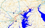
Interstate 95 in Maryland
is a major highway that runs diagonally from northeast to southwest, from Maryland's border with Delaware
, to the Woodrow Wilson Bridge
, briefly entering the District of Columbia before reaching Virginia
. The route is one of the most heavily traveled Interstate Highways
in Maryland, especially between Baltimore and Washington, D.C.
, despite alternate routes along the corridor, such as the Baltimore-Washington Parkway
, U.S. 1
, and U.S. Route 29
. Portions of the highway are tolled
.
Between the Delaware state line and the Baltimore City line, I-95 is known as the John F. Kennedy Memorial Highway.
, the roadways, four lanes in either direction, travel together over the Woodrow Wilson Memorial Bridge, briefly cross the southern tip of the District of Columbia (over water), and touch down in Prince George's County
west of Forest Heights
. I-95/I-495 immediately encounter the southern terminus of Interstate 295, known as the Anacostia Freeway, a route that serves downtown Washington D.C. and connects to the originally planned alignment of I-95 through D.C., Interstate 395. Just beyond I-295 the two routes interchange with MD 210
, a major north–south route into southern D.C.
The two Interstates continue along the Capital Beltway, interchanging with various local highways such as MD 5
(Branch Avenue) and MD 4
(Pennsylvania Avenue
) on either side of Andrews Air Force Base
, which the Beltway travels very close to near its northern edge. Turning north past the MD 4 interchange, the Beltway runs through Glenarden
, interchanging with MD 202
, US 50/secret Interstate 595
, and MD 450
, the latter route offering access to the New Carrollton metro station
and the New Carrollton
metropolitan area.
Turning northwest the Beltway enters Greenbelt Park
, intersecting the Baltimore-Washington Parkway
in the northeastern edge of the park. Just after the B-W Parkway the two routes interchange with MD 201
, which connects to the southern terminus of the B-W Parkway at US 50
(New York Avenue) near the D.C. line. Now turned fully west, the Beltway runs through the northern edge of College Park
, interchanging with the College Park metro station
's access roadway and US 1
.
Beyond the US 1 interchange, I-95 encounters its own route at the College Park Interchange
, and separates from I-495 within this interchange. I-495 continues west, alone, on the Capital Beltway to Interstate 270
, while I-95 turns north onto its own planned alignment. The interchange includes access to a Park and Ride
.
, interchanging with MD 212
near the community. The highway, completed in 1971, runs through undeveloped land to the interchange with the temporary eastern terminus of the Intercounty Connector
toll road
(MD 200) before interchanging with MD 198
just west of Laurel
. Passing over the Patuxent River
just south of the Rocky Gorge Dam, the route enters Howard County
and promptly interchanges with MD 216
. North of the MD 216 interchange, the route encounters its first rest area in the state of Maryland, with each carriageway served by its own facility. Continuing northeast, I-95 intersects MD 32
at a modified directional cloverleaf. Within this interchange, I-95 grade-separates, with the northbound carriageway passing over MD 32 and the southbound carriageway passing under MD 32, allowing left exits from both of the latter's carriageways to merge into the left lanes of I-95 without conflict.
North of this unusual interchange, I-95 encounters MD 175
, the main access route into Columbia
, at a less-radical directional cloverleaf interchange. After the MD 175 interchange comes the MD 100
interchange, providing access to Ellicott City
, US 29
, and Interstate 70
to the west, and the Baltimore-Washington Parkway
and Interstate 97
to the east. Just beyond this interchange, I-95 encounters three more of its auxiliary routes within Maryland: Interstate 895
, which splits at a directional wye within the Patapsco Valley State Park
, just south of the Patapsco River
; Interstate 195
, a short spur to Baltimore-Washington International Airport, and Interstate 695
, the Baltimore Beltway, a full-circle beltway around Baltimore that offers a full freeway bypass of the city and that connects to Interstate 70
, Interstate 83
, and Interstate 97
. Traffic not authorized to make use of either of the direct (tunnel) routes through Baltimore is encouraged to use the eastern half of I-695
, which crosses the Patapsco River
via the Francis Scott Key Bridge
.
 South of Baltimore, I-95 is maintained by the Maryland State Highway Administration
; north of the southern Baltimore city line, I-95 changes jurisdiction to the Maryland Transportation Authority
. Continuing on its northeasterly track, the route intersects US 1 Alt. just beyond the city line. I-95's interchange with US 1 Alt. incorporates stubs and unused embankments that would have been used for the planned eastern terminus of I-70
within Baltimore (later planned as the southern terminus of I-595
, before that designation was moved to US 50
east of Washington
). Continuing past this unbuilt interchange, I-95 intersects Washington Blvd., a local city street, before encountering the main access route into the central business district, Interstate 395
. I-95 also interchanges with the northern terminus of the Baltimore-Washington Parkway
within the I-395 interchange, which is almost completely elevated over the Middle Branch of the Patapsco River
. After interchanging with both routes, I-95 interchanges with MD 2
and Key Highway, the latter route offering access to Fort McHenry
and an escape route for hazardous material traffic.
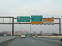
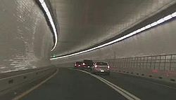
I-95 encounters the Fort McHenry Tunnel south of Fort McHenry
. The tunnel, containing eight lanes, curves underneath the Northwest Harbor and emerges in the Canton neighborhood of Baltimore, quickly encountering the toll plaza. After the toll plaza, I-95 encounters the Boston St.-O'Donnell St. interchange, which also incorporates stubs and other unused infrastructure planned to be used for the southern terminus of Interstate 83
; I-95 also passes over I-895
within the interchange area, with no access between the two routes, then runs into East Baltimore, providing local access to various city streets in lieu of I-895. It interchanges with the Moravia Road freeway spur next to the Baltimore city line (where ramp stubs were once planned for an unbuilt portion of the Windlass Freeway), then connects with US 40
before narrowing to six lanes and merging with I-895
just after exiting Baltimore.
 The John F. Kennedy Memorial Highway is an eight lane highway on I-95 that begins at the end of the Harbor Tunnel Thruway at the Baltimore
city line. After three miles (3 km), I-95 once again intersects with Interstate 695
at what was a unique double-crossover interchange. Within this interchange, the carriageways of I-95 narrowed to six lanes and crossed over each over, thereby putting through traffic on the left within the interchange nexus, allowing left exit ramps and left entrance ramps to accommodate four of the eight movements in lieu of flyovers. Beyond the interchange, both sets of carriageways crossed over each other again and resumed right-hand running. As part of the upgrades to Interstate 95 to accommodate express toll lanes in this area, this interchange was replaced with a more conventional four-level stack; all exits are now on the right, and I-95's carriageways no longer cross over one another.
Continuing to the northeast, parallel with the Chesapeake Bay
, the route encounters MD 43
near White Marsh
. After passing through Gunpowder Falls State Park
, the route interchanges with MD 152
north of Joppatowne
, then with MD 24
, providing access to Bel Air and Edgewood
. Within the MD 24 interchange, I-95 narrows to six lanes and remains this wide to the Delaware
border.
Just beyond the MD 543
, I-95's carriageways split apart to provide space for Maryland House, I-95's second service area. Maryland House is a full service rest area that offers food, fuel and other amenities, and opened with the toll highway in 1963. Beyond Maryland House, the route encounters the MD 22
interchange in Aberdeen
, providing access to the Aberdeen Proving Ground
. South of the Susquehanna State Park
, I-95 encounters the southern end of the remaining tolled portion of the highway at the MD 155
interchange, providing access to Havre de Grace
and US 40
.
North of this interchange, I-95 becomes a true toll route as it passes through the Susquehanna State Park before crossing the Millard E. Tydings Memorial Bridge
over the Susquehanna River
. The bridge crosses between bluffs high above the river valley, and is posted with warning signs: "Subject to Crosswinds". Just beyond the bridge is the JFK Highway toll plaza at Perryville; where tolls are collected in the northbound direction only. There are no southbound tolls on the highway, but southbound truck traffic may need to stop at a nearby weigh station. At the northern end of the plaza is Exit 93 for MD 222
in Perryville
, before continuing to the Delaware State line.
Still paralleling the northern shore of the Chesapeake Bay
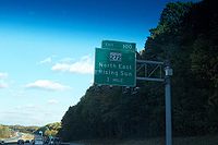
, I-95's carriageways split apart again to encounter its third service area in Maryland, Chesapeake House. This service area opened in 1975 (after the highway was widened from four to six lanes in 1972), and offers the same amenities as Maryland House. Now past the northern tip of the bay, north of Elk Neck State Park
, the route encounters MD 272
, which provides access to the towns of North East
and Rising Sun
. Having turned east, the route now runs straight towards the Delaware
state line, passing under MD 213
north of Elkton
with no access offered. Finally, I-95's run through Maryland comes to an end after the Exit 109 interchange with MD 279
, with a direct route into Elkton
and Newark, Delaware
, just before crossing the Delaware
state line where the JFK Highway connects to the Delaware Turnpike
and where Newark
toll plaza is located on the Turnpike (which is not warned of by the MD 279 interchange).
, opened in 1963, at milepost 82 in Harford County, and Chesapeake House
, opened in 1975, at milepost 97 in Cecil County. As of 2009, the MdTA
is engaged in a process to identify a contractor to re-develop the two service areas, which are considered out-dated and worn.
The MdTA
has been planning to redevelop the Maryland House and Chesapeake House
service areas for some time, but a competitive process with a request for proposals (RFP) was canceled by the state in November 2010, and a new RFP was issued in June 2011.
There is also a rest area between Baltimore and Washington, D.C., located in Howard County
. Unlike the above two rest areas, which are located in the median, this rest area is located on the shoulders, with separate facilities for each direction of travel.
.svg.png)
to the College Park Interchange
. Instead, it would have exited the District at New Hampshire Avenue (MD 650
), following the Northeast Freeway, and after passing through Northwest Branch Park, junctioned I-495 at the College Park Interchange
, integrating seamlessly with the existing segment of I-95 at that interchange. This route was canceled in 1977, and I-95 rerouted, after the District government canceled the North Central Freeway
, which would have linked to the Northeast Freeway at its southern end and carried I-95 deeper into the District. The part of I-95 that was completed from downtown Washington to the Springfield Interchange
in Springfield, Virginia
was then re-designated as I-395.
(as it was known then) and run due east, crossing the city to the north of the Inner Harbor on an elevated viaduct within the central business district. The route would have met two other freeways—the Jones Falls Expressway and the Southwest Expressway—at a four-way interchange in the southeast edge of the CBD; I-95 would have followed the Southwest Expressway, and met both I-70N and I-83 (on the Jones Falls Expressway) at this interchange. I-70N and I-83 would have terminated at the interchange, while I-95 would have turned east and followed the East–West Expressway out of the CBD, along the Boston Street corridor and out towards East Baltimore, intersecting the Harbor Tunnel Thruway
near today's Exit 62. The Southwest Expressway would have cut through Federal Hill
and crossed the Inner Harbor on a fixed bridge with 50 feet (15.2 m) of vertical navigational clearance. All of these proposed routes would have required extensive right-of-way acquisition and clearance.
The above routings were eventually further refined and modified and eventually became part of the Baltimore 10-D Interstate System, approved in 1962. In this plan, I-95 would run east–west to the north of Fort McHenry
, similarly to the above proposal, but would have run along the southern edge of the CBD, passing to the north of Federal Hill
and cutting through the historic Fells Point neighborhood. After crossing the Inner Harbor on another low bridge, it would have followed the Boston Street corridor, crossing the Harbor Tunnel Thruway
near to where it does today, then followed the existing I-95 alignment out of the city. The highway would have junctioned Interstate 70N a mile to the northwest of the Inner Harbor, near the eastern terminus of the now-defunct Interstate 170
; it would have met Interstate 83 in the northeastern corner of the central business district. This routing was little different to the routings proposed in 1960, and was also universally disliked.
By 1969, the Design Concept Team, a multi-discipline group assembled in 1966 by the city government to help design freeway routings that would not disrupt the city's fabric, the 10-D System had been replaced by the Baltimore 3-A Interstate and Boulevard System. In the 3-A system, I-95 was shifted south onto the Locust Point peninsula, and eventually constructed there. I-70N would have run through Leakin Park and Gwynns Falls Park to terminate at I-95 near Alt US 1, while I-83 was shifted to a new alignment and planned to terminate at I-95 north of the Patapsco River
. Interstate 395
was also brought into existence under this plan; it was planned as a freeway spur from I-95 to the south edge of the central business district, connecting to a new route named City Boulevard (now known as Martin Luther King Jr. Boulevard). The 3-A System's result was that I-95 would act as a bypass of the central business district, with I-395 providing direct access.
and the Baltimore Beltway; beyond the southern I-695
interchange, the highway came to a dead halt at Alt US 1. By 1974, I-95 was under construction in East Baltimore between its current merge with I-895
south to a partial-cloverleaf interchange with MD 150
Eastern Avenue. By 1976, I-95 was under construction east of Alt US 1 and south of MD 150. By 1981, I-95 was completed as far as I-395, and by 1984, with the construction of the Fort McHenry Tunnel quite advanced, the route was open as far as MD 2
west of the Patapsco, and Boston St.-O'Donnell St. east of the Patapsco. With the final opening of the tunnel on November 23, 1985, I-95 was finally completed within the city of Baltimore.
 Originally, the toll plaza at the north end of the Fort McHenry Tunnel was to be removed after the city of Baltimore repaid its share of the construction costs of the tunnel. However, the Maryland Transportation Authority
lobbied successfully to keep the toll plaza in place to prevent a traffic problem on I-95 within Baltimore.
in the mid-1950s, the construction of the Baltimore
and Washington, D.C. beltways
had diverted most of the state funds that would have been used to build it. To relieve traffic on U.S. Route 40
, it was decided to finance construction using a bond issue. The Maryland State Roads Commission, the predecessor to the Maryland Transportation Authority
(MdTA), floated $73 million in revenue bond
s to provide funds to start construction of the route, which began in January 1962.
Completed in 1963, the 48 mile Northeastern Expressway and the adjoining 11 mile Delaware Turnpike
were dedicated by President John F. Kennedy
on Thursday, November 14, 1963, at a ceremony at the Mason-Dixon Line
. In 1964, the highway was re-named the John F. Kennedy Memorial Highway after his assassination
in Dallas, Texas
, on November 22, 1963, eight days after President Kennedy was on hand for the opening of the two highways.
Between 1963 and 1993, the John F. Kennedy Memorial Highway was a tolled facility
for the entire length of the roadway in both directions. The mainline toll plaza is situated just north of the Susqehanna River Bridge in Perryville
. The southbound toll plaza was removed in 1991, but tolls are still collected for northbound traffic at this location. Additionally, ramp tolls were collected at many of the interchanges until they were abolished by an act of the legislature in 1981. The highway and bridge are maintained by the MdTA.
Exits on the John F. Kennedy Memorial Highway were originally numbered consecutively, beginning with exit 1. As a result, Interstate 95 in Maryland had multiple conflicting sequences of exit numbers. In the mid-1980s, the exits were re-numbered according to a statewide, mileage-based numbering system, so that they now range from Exit 2 (I-295 north) on the Capital Beltway
to Exit 109 (MD 279
) on the John F. Kennedy Memorial Highway.
. Between Exit 57 and the Baltimore city line the route was again maintained by the city of Baltimore.
Now, between the southern Baltimore city line (near Exit 49, the southern I-695
interchange) and the northern Baltimore city line, the route is maintained entirely by the Maryland Transportation Authority
. Maryland state highway police force and the authority's own police force share police duties on this segment. Additionally, the city of Baltimore pays the MdTA to maintain I-95 within the city limits.
, the site of the northern crossing of I-95 and I-495 and the northern end of the Northeast Freeway. This interchange, while technically incomplete, was modified in late 1986 to bring it fully into service; today, all parts of the interchange are in regular use. The other three interchanges are located in the city of Baltimore, a sign of the many successful freeway revolts that accompanied the construction of the 3-A System: the planned eastern terminus of Interstate 70
; the planned southern terminus of Interstate 83
; and the planned southern terminus of the Windlass Freeway. All three unbuilt interchanges incorporate interchanges with local roads.
The first is located near Exit 50 in Baltimore; it is the site of the planned eastern terminus of Interstate 70 within the city. The only remnants of the interchange that remain in situ today are the mainline bridges built to grade-separate I-95 and the exit ramps to and from I-70, several ramp stubs, and a few grassy abutments. An incomplete flyover bridge once existed as well, but was later demolished. While this interchange was left incomplete, the existing Exit 50, built with extensive collector-distributor lanes due to its proximity to the unbuilt interchange, stands as a more visible sign of what was planned. Today, Exit 50 connects Alt US 1 to I-95.
The second is located near Exit 57, just to the north of the Fort McHenry Tunnel, and is the site of the planned southern terminus of Interstate 83. Like I-70's terminus, the remnants here consist mainly of ramp stubs and unused bridges. This interchange, like Exit 50, also serves Boston Street and O'Donnell Street; unlike Exit 50, I-95 narrows to six lanes within the interchange, as most traffic was expected to diverge onto I-83 north and thus into the downtown area. The interchange would have been a 3-way freeway-to-freeway interchange, with a full complement of ramps provided for local access to and from Boston Street and O'Donnell Street, to and from both Interstates. Of the two planned Interstate termini, I-83's terminus was the first to be abandoned, with the connecting highway segment being cancelled in September 1982; I-70's terminus, later redesignated as a new route, was cancelled in July 1983.
The third is encountered at Exit 60 and is the site of the southwestern terminus of the Windlass Freeway, a relief route for US 40 (part of the route was eventually built and is today part of I-695
). The interchange that exists at this site is in partial use, serving the Moravia Road freeway spur; like the other two inner-city locations, ramp stubs mark the site of the ramps to and from the unbuilt freeway.
has begun the process of significantly expanding the highway to increase its capacity. The expansion plans are divided into short, individual sections; in 2001, the MdTA began public studies to determine the best way to expand the highway to meet current and future needs. After four years of study, the MdTA issued its results for Section 100, the southernmost section.
) and milepost 70. This segment is currently eight lanes wide (a 4–4 configuration) and carries approximately 165,000 vehicles per day (expected to increase to 225,000 vehicles per day by 2025). The plan is to widen this segment to twelve lanes (a 4-2-2-4 configuration), with the center lanes designated as express toll lanes. In addition, the interchange between the JFK Highway and the Baltimore Beltway
at Exit 64 has been rebuilt into a more orthodox stack interchange
, removing the left entrances and exits as well as the unique carriageway crossovers on I-95 (the carriageway crossovers on I-695 there remained). The interchange at Exit 67 (MD 43
) will also be significantly modified from its current cloverleaf configuration, and the interchange at Exit 62 will be reconfigured so that I-95 will replace I-895 as the straight-ahead route, thus eliminating the need for southbound I-95 traffic to weave to the right and cross over.
The project is expected to cost $1.2 billion. It began in 2006 and is expected to be completed in 2012.
). This segment is also currently eight lanes wide (a 4–4 configuration) as far as Exit 77 (MD 24
), and is currently six lanes wide (a 3–3 configuration) between Exit 77 and Exit 85. Like Section 100, this segment will likely be widened into a 4-2-2-4 configuration as far as Exit 80 (MD 543
). Between Exit 80 and Exit 85, the remainder will likely be widened from a 3–3 configuration to a 4–4 configuration. While the MdTA has not yet finalized plans for this segment, a project is currently underway to improve the MD 24 interchange as part of any future works; this project began in 2006 and will be completed in 2009.
.
, at the request of an assortment of elected officials,
completed a study which examined a relocation of the northbound toll barrier, which is currently just north of the Tydings Bridge
crossing of the Susquehanna River
at Perryville
. The study concluded was that the barrier should remain where it is, because "relocating the toll plaza from the current location would result in significant diversion from I-95 onto local Cecil County roads" and "the closer the toll plaza goes to Delaware the greater the diversion there is to local roads, the greater the revenue loss to the state toll operator MdTA, and the more travel there is on slower, less safe surface arterials."
|-
!County/City
!Location
!Mile
!Exit
!Destinations
!Notes
|-
|rowspan=2 colspan=2|Virginia
state line
|rowspan=2|0.00
|
|
|Southern terminus of I-95 / I-495 in Maryland
|-
| colspan="3" style="text-align:center;"|Woodrow Wilson Bridge
– Potomac River
|-
|rowspan=23|Prince George's
|rowspan=4|Oxon Hill
|-
|1.73
|2
| / National Harbor Boulevard – Washington
, National Harbor
|Split into exits 2A (National Harbor) and 2B (I-295)
|-
|2.77
|3
|
|Split into exits 3A (south) and 3B (north) northbound
|-
|4.33
|4
|
|Split into exits 4A (south) and 4B (north)
|-
||Temple Hills
|7.30
|7
|
|Split into exits 7A (south) and 7B (north)
|-
|rowspan=2|Morningside
|9.07
|rowspan=2|9
|rowspan=2|
|Northbound exit and southbound entrance
|-
|9.69
|Southbound exit and northbound entrance
|-
||Forestville
|10.78
|11
|, Washington
|Split into exits 11A (south) and 11B (north)
|-
|rowspan=3|Largo
|13.14
|13
|Ritchie–Marlboro Road – Capitol Heights
, Upper Marlboro
|Unsigned MD 221A
|-
|14.78
|15
|
|Split into exits 15A (east) and 15B (west)
|-
|15.83
|16
|Arena Drive
|Unsigned MD 202F
|-
||Landover
|16.56
|17
|
|Split into exits 17A (east) and 17B (west) southbound
|-
||Glenarden
|18.54
|19
|, Washington
|I-595 is unsigned; split into exits 19A (east) and 19B (west)
|-
||New Carrollton
|19.59
|20
|
|Split into exits 20A (east) and 20B (west) northbound
|-
|rowspan=3|Greenbelt
|22.12
|22
|, Washington
|MD 295 is unsigned; split into exits 22A (north) and 22B (south)
|-
|23.04
|23
|
|
|-
|24.25
|24
|Greenbelt Metro Station
|Southbound exit and northbound entrance
|-
|rowspan=2|College Park
|25.19
|25
|
|Split into exits 25A (north) and 25B (south) southbound
|-
|26.11
|27
|, Park and Ride
|College Park Interchange
; north end of concurrency with I-495; southbound I-95 uses exit 27 to access exit 25 and the park and ride
|-
||Beltsville
|28.54
|29
|
|Split into exits 29A (east) and 29B (west)
|-
|rowspan=3|Laurel
|style="background:#ffdead"|
|style="background:#ffdead"|31A
|style="background:#ffdead"|
|style="background:#ffdead"|Under construction; expected to open 2014
|-
|
|31B
|
|Opened November 22, 2011
|-
|32.70
|33
|
|Split into exits 33A (east) and 33B (west)
|-
|colspan=2|
|34.10
| colspan="3" style="text-align:center;"|Patuxent River
|-
|rowspan=5|Howard
||North Laurel
|
|35
|
|Split into exits 35A (south) and 35B (north)
|-
||Savage
|
|38
|
|Split into exits 38A (south) and 38B (north)
|-
||Jessup
|
|41
|
|Split into exits 41A (south) and 41B (north)
|-
|rowspan=2|Elkridge
|
|43
|
|Split into exits 43A (east) and 43B (west)
|-
|
|46
|
|Northbound exit and southbound entrance
|-
|colspan=2|
|45.69
| colspan="3" style="text-align:center;"|Patapsco River
|-
|rowspan=2|Baltimore County
|rowspan=2|Arbutus
|0
|47
|
|Split into exits 47A (south) and 47B (north)
|-
|
|49
|
|Split into exits 49A (east) and 49B (north)
|-
|rowspan=18 colspan=2|Baltimore City
|
|50
|
|US 1 Alt. is unsigned; split into exits 50A (south) and 50B (north)
|-
|
|51
|Washington Boulevard
|Northbound exit and southbound entrance
|-
|rowspan=2|
|rowspan=2|52
|
|MD 295 is unsigned for Russell Street; northbound exit and southbound entrance to and from Russell Street
|-
|
|Southbound exit and northbound entrance to and from Baltimore–Washington Parkway
|-
|
|53
| to Martin Luther King Jr. Boulevard – Downtown Baltimore
|
|-
|
|54
|
|Northbound exit and southbound entrance
|-
|
|55
|Key Highway – Fort McHenry National Monument
|
|-
|
| rowspan="2" colspan="3" style="text-align:center;"|Fort McHenry Tunnel – Patapsco River
|-
|
|-
|
| colspan="3" style="text-align:center;"|Fort McHenry Tunnel Toll Plaza
|-
|
|56
|Keith Avenue
|
|-
|
|rowspan=2|57
|Boston Street
|Northbound exit and southbound entrance
|-
|
|O'Donnell Street
|Southbound exit and northbound entrance
|-
|
|58
|Dundalk Avenue south
|Northbound exit and southbound entrance
|-
|
|59
|
|
|-
|
|60
|Moravia Road north
|Northbound exit and southbound entrance
|-
|
|61
|
|Northbound exit and southbound entrance
|-
|0
|62
|
|Southbound exit and northbound entrance
|-
|rowspan=2|Baltimore County
|Rosedale
|
|64
|
|Split into exits 64A (south) and 64B (west)
|-
||White Marsh
|0
|67
|
|Split into exits 67A (south) and 67B (north)
|-
|colspan=2|
|72.16
| colspan="3" style="text-align:center;"|Little Gunpowder Falls
|-
|rowspan=5|Harford County
||Joppa
|
|74
|
|
|-
||Edgewood
|
|77
|
|Split into exits 77A (south) and 77B (north)
|-
||Riverside
|0
|80
|, Riverside
|
|-
||Aberdeen
|
|85
|
|
|-
||Havre de Grace
|
|89
|
|
|-
|rowspan=2 colspan=2|
|
| rowspan="2" colspan="3" style="text-align:center;"|Millard E. Tydings Memorial Bridge
– Susquehanna River
|-
|0
|-
|rowspan=4|Cecil
|rowspan=2|Perryville
|
| colspan="3" style="text-align:center;"|John F. Kennedy Memorial Highway Toll Plaza (northbound only)
|-
|
|93
|
|
|-
||North East
|
|100
|
|Split into exits 100A (south) and 100B (north) southbound
|-
||Elkton
|
|109
|, Newark, DE
|Split into exits 109A (west) and 109B (east)
|-
|colspan=2|Delaware
state line
|109.05
|
|
||Northern terminus of I-95 in Maryland
Maryland
Maryland is a U.S. state located in the Mid Atlantic region of the United States, bordering Virginia, West Virginia, and the District of Columbia to its south and west; Pennsylvania to its north; and Delaware to its east...
is a major highway that runs diagonally from northeast to southwest, from Maryland's border with Delaware
Delaware
Delaware is a U.S. state located on the Atlantic Coast in the Mid-Atlantic region of the United States. It is bordered to the south and west by Maryland, and to the north by Pennsylvania...
, to the Woodrow Wilson Bridge
Woodrow Wilson Bridge
The Woodrow Wilson Memorial Bridge is a bascule bridge that spans the Potomac River between the independent city of Alexandria, Virginia and Oxon Hill in Prince George's County, Maryland, United States. While over the water near the Virginia shore, it crosses the southern tip of the District of...
, briefly entering the District of Columbia before reaching Virginia
Virginia
The Commonwealth of Virginia , is a U.S. state on the Atlantic Coast of the Southern United States. Virginia is nicknamed the "Old Dominion" and sometimes the "Mother of Presidents" after the eight U.S. presidents born there...
. The route is one of the most heavily traveled Interstate Highways
Interstate Highway System
The Dwight D. Eisenhower National System of Interstate and Defense Highways, , is a network of limited-access roads including freeways, highways, and expressways forming part of the National Highway System of the United States of America...
in Maryland, especially between Baltimore and Washington, D.C.
Washington, D.C.
Washington, D.C., formally the District of Columbia and commonly referred to as Washington, "the District", or simply D.C., is the capital of the United States. On July 16, 1790, the United States Congress approved the creation of a permanent national capital as permitted by the U.S. Constitution....
, despite alternate routes along the corridor, such as the Baltimore-Washington Parkway
Baltimore-Washington Parkway
The Baltimore–Washington Parkway is a highway in the U.S. state of Maryland, running southwest from Baltimore to Washington, D.C. The road begins at an interchange with U.S. Route 50 and Maryland Route 201 near Cheverly in Prince George's County at the D.C...
, U.S. 1
U.S. Route 1 in Maryland
U.S. Route 1 is the easternmost and longest of the major north–south routes of the United States Numbered Highway System, running from Key West, Florida to Fort Kent, Maine. In the U.S...
, and U.S. Route 29
U.S. Route 29
U.S. Route 29 is a north–south United States highway that runs for from the western suburbs of Baltimore, Maryland, to Pensacola, Florida. This highway's northern terminus is at Maryland Route 99 in Ellicott City, Maryland...
. Portions of the highway are tolled
Toll road
A toll road is a privately or publicly built road for which a driver pays a toll for use. Structures for which tolls are charged include toll bridges and toll tunnels. Non-toll roads are financed using other sources of revenue, most typically fuel tax or general tax funds...
.
Between the Delaware state line and the Baltimore City line, I-95 is known as the John F. Kennedy Memorial Highway.
Capital Beltway
Interstate 95 enters the state of Maryland concurrent with Interstate 495, the Capital Beltway. From Alexandria, VirginiaAlexandria, Virginia
Alexandria is an independent city in the Commonwealth of Virginia. As of 2009, the city had a total population of 139,966. Located along the Western bank of the Potomac River, Alexandria is approximately six miles south of downtown Washington, D.C.Like the rest of northern Virginia, as well as...
, the roadways, four lanes in either direction, travel together over the Woodrow Wilson Memorial Bridge, briefly cross the southern tip of the District of Columbia (over water), and touch down in Prince George's County
Prince George's County, Maryland
Prince George's County is a county located in the U.S. state of Maryland, immediately north, east, and south of Washington, DC. As of 2010, it has a population of 863,420 and is the wealthiest African-American majority county in the nation....
west of Forest Heights
Forest Heights, Maryland
Forest Heights, officially the Town of Forest Heights is a town in Prince George's County, Maryland, United States, with an African-American majority population, and part of the larger postal designation Oxon Hill, MD. Students attend Oxon Hill High School. The town straddles both sides of...
. I-95/I-495 immediately encounter the southern terminus of Interstate 295, known as the Anacostia Freeway, a route that serves downtown Washington D.C. and connects to the originally planned alignment of I-95 through D.C., Interstate 395. Just beyond I-295 the two routes interchange with MD 210
Maryland Route 210
Maryland Route 210 , or Indian Head Highway, is a state highway in Prince George's and Charles counties in Maryland. At its northern end, MD 210 starts from the end of South Capitol Street in Washington, D.C., connecting the U.S. Capitol with Indian Head, Maryland...
, a major north–south route into southern D.C.
The two Interstates continue along the Capital Beltway, interchanging with various local highways such as MD 5
Maryland Route 5
Maryland Route 5 is a long state highway that runs north–south in the U.S. state of Maryland. The highway runs from Point Lookout in St. Mary's County north to the Washington, D.C. border in Suitland, Prince George's County....
(Branch Avenue) and MD 4
Maryland Route 4
Maryland Route 4 is a state highway in the U.S. state of Maryland. The state highway runs from MD 5 in Leonardtown north to Southern Avenue at the Washington, D.C. border, past which the highway continues as Pennsylvania Avenue...
(Pennsylvania Avenue
Pennsylvania Avenue
Pennsylvania Avenue is a street in Washington, D.C. that joins the White House and the United States Capitol. Called "America's Main Street", it is the location of official parades and processions, as well as protest marches...
) on either side of Andrews Air Force Base
Andrews Air Force Base
Joint Base Andrews is a United States military facility located in Prince George's County, Maryland. The facility is under the jurisdiction of the United States Air Force 11th Wing, Air Force District of Washington ....
, which the Beltway travels very close to near its northern edge. Turning north past the MD 4 interchange, the Beltway runs through Glenarden
Glenarden, Maryland
Glenarden is a city in Prince George's County, Maryland, United States. The population was 6,000 at the 2010 census.-Geography:Glenarden is located at ....
, interchanging with MD 202
Maryland Route 202
Maryland Route 202 is a north–south state highway in Prince George's County within the U.S. state of Maryland. MD 202 travels through many communities in central Prince George's County, and is known as Maryland Route 202 (MD 202) is a north–south state highway in Prince George's...
, US 50/secret Interstate 595
Interstate 595 (Maryland)
Interstate 595 is an unsigned number for a section of the John Hanson Highway from Interstate 495 east of Washington, D.C. to Maryland Route 70 at Annapolis, Maryland....
, and MD 450
Maryland Route 450
Maryland Route 450 is a state highway in the U.S. state of Maryland. The state highway runs from U.S. Route 1 Alternate in Bladensburg east to US 50, US 301, and MD 2 near Annapolis. MD 450 is the original alignment of US 50 in Prince George's and Anne Arundel Counties...
, the latter route offering access to the New Carrollton metro station
New Carrollton (Washington Metro)
New Carrollton rail station is a joint Washington Metro, MARC, and Amtrak station in New Carrollton, Prince George's County, Maryland at the eastern end of the Orange Line and planned Purple Line, and adjacent to the Capital Beltway. The Amtrak waiting room is located beneath the Metro station...
and the New Carrollton
New Carrollton, Maryland
New Carrollton is a city located in central Prince George's County, Maryland, in the United States. As of the 2000 census, population was 12,589.New Carrollton is 12.11 miles from central Washington, DC....
metropolitan area.
Turning northwest the Beltway enters Greenbelt Park
Greenbelt Park
Greenbelt Park, located in Greenbelt, Maryland, is managed by the United States National Park Service. The forested park lies approximately 10 miles northeast of Washington, D.C., and is situated just within the Capital Beltway . The park land was originally intended to form part of the green...
, intersecting the Baltimore-Washington Parkway
Baltimore-Washington Parkway
The Baltimore–Washington Parkway is a highway in the U.S. state of Maryland, running southwest from Baltimore to Washington, D.C. The road begins at an interchange with U.S. Route 50 and Maryland Route 201 near Cheverly in Prince George's County at the D.C...
in the northeastern edge of the park. Just after the B-W Parkway the two routes interchange with MD 201
Maryland Route 201
-Route description:MD 201 begins at a large hybrid cloverleaf just outside the D.C. boundary at Tuxedo, Maryland that is maintained by the Maryland State Highway Administration...
, which connects to the southern terminus of the B-W Parkway at US 50
U.S. Route 50 in Maryland
U.S. Route 50 is a major east–west route of the U.S. Highway system, stretching just over from Ocean City, Maryland on the Atlantic Ocean to West Sacramento, California. In the U.S. state of Maryland, US 50 exists in two sections. The longer of these serves as a major route connecting...
(New York Avenue) near the D.C. line. Now turned fully west, the Beltway runs through the northern edge of College Park
College Park, Maryland
College Park is a city in Prince George's County, Maryland, USA. The population was 30,413 at the 2010 census. It is best known as the home of the University of Maryland, College Park, and since 1994 the city has also been home to the "Archives II" facility of the U.S...
, interchanging with the College Park metro station
College Park-U of Md (Washington Metro)
College Park – University of Maryland is a Washington Metro station in Prince George's County, Maryland on the Green Line.The station is located in College Park near the University of Maryland, College Park, with entrances at the intersection of Calvert Road and Bowdoin Avenue, and near the...
's access roadway and US 1
U.S. Route 1 in Maryland
U.S. Route 1 is the easternmost and longest of the major north–south routes of the United States Numbered Highway System, running from Key West, Florida to Fort Kent, Maine. In the U.S...
.
Beyond the US 1 interchange, I-95 encounters its own route at the College Park Interchange
College Park Interchange
The College Park Interchange is the southern end of the segment of Interstate 95 in Maryland between the Baltimore Beltway and the Capital Beltway ; it is the point where Interstate 95 and Interstate 495 join with one another within Maryland....
, and separates from I-495 within this interchange. I-495 continues west, alone, on the Capital Beltway to Interstate 270
Interstate 270 (Maryland)
Interstate 270 is a auxiliary Interstate Highway in the U.S. state of Maryland that travels between Interstate 495 just north of Bethesda, Montgomery County and Interstate 70 in the city of Frederick in Frederick County. It consists of the mainline as well as a spur that provides access to and...
, while I-95 turns north onto its own planned alignment. The interchange includes access to a Park and Ride
Park and ride
Park and ride facilities are car parks with connections to public transport that allow commuters and other people wishing to travel into city centres to leave their vehicles and transfer to a bus, rail system , or carpool for the rest of their trip...
.
Between the Beltways
Running northeast, I-95, still eight lanes wide, passes through BeltsvilleBeltsville, Maryland
Beltsville is a census-designated place in northern Prince George's County, Maryland, United States. The population was 15,691 at the 2000 census. Beltsville includes the unincorporated community of Vansville.-Geography:...
, interchanging with MD 212
Maryland Route 212
Maryland Route 212, also known as Riggs Road south of MD 193 and Powder Mill Road to its northern end, is a state highway which crosses northern Prince George's County.-Route description:...
near the community. The highway, completed in 1971, runs through undeveloped land to the interchange with the temporary eastern terminus of the Intercounty Connector
Intercounty Connector
Maryland Route 200 , more commonly known as the Intercounty Connector or ICC, is a partially completed toll freeway under construction in Maryland which connects Gaithersburg in Montgomery County and Laurel in Prince George's County. When completed, it will reach the community of Konterra just...
toll road
Toll road
A toll road is a privately or publicly built road for which a driver pays a toll for use. Structures for which tolls are charged include toll bridges and toll tunnels. Non-toll roads are financed using other sources of revenue, most typically fuel tax or general tax funds...
(MD 200) before interchanging with MD 198
Maryland Route 198
Maryland Route 198 is an east–west state highway in the central part of the U.S. state of Maryland that connects Fort Meade at Maryland Route 32 to Maryland Route 28 and Maryland Route 650 near Spencerville.-Spencerville Road:...
just west of Laurel
Laurel, Maryland
Laurel is a city in northern Prince George's County, Anne Arundel County, and Howard County, Maryland, United States, located midway between Washington, D.C. and Baltimore. Incorporated in 1870, the city maintains a historic district including its Main Street...
. Passing over the Patuxent River
Patuxent River
The Patuxent River is a tributary of the Chesapeake Bay in the state of Maryland. There are three main river drainages for central Maryland: the Potomac River to the west passing through Washington D.C., the Patapsco River to the northeast passing through Baltimore, and the Patuxent River between...
just south of the Rocky Gorge Dam, the route enters Howard County
Howard County, Maryland
-2010:Whereas according to the 2010 U.S. Census Bureau:*62.2% White*17.5% Black*0.3% Native American*14.4% Asian*0.0% Native Hawaiian or Pacific Islander*3.6% Two or more races*2.0% Other races*5.8% Hispanic or Latino -2000:...
and promptly interchanges with MD 216
Maryland Route 216
Maryland Route 216 is a Maryland between Laurel and Highland, primarily within Howard County. The name for Route 216 is Scaggsville Road.-7th Street, Laurel:...
. North of the MD 216 interchange, the route encounters its first rest area in the state of Maryland, with each carriageway served by its own facility. Continuing northeast, I-95 intersects MD 32
Maryland Route 32
Maryland Route 32 is a state highway in the U.S. state of Maryland. The state highway runs from Interstate 97 and MD 3 in Millersville west and north to Washington Road in Westminster. The east–west portion of MD 32 is the Patuxent Freeway, a four- to six-lane...
at a modified directional cloverleaf. Within this interchange, I-95 grade-separates, with the northbound carriageway passing over MD 32 and the southbound carriageway passing under MD 32, allowing left exits from both of the latter's carriageways to merge into the left lanes of I-95 without conflict.
North of this unusual interchange, I-95 encounters MD 175
Maryland Route 175
-Annapolis Road:MD 175 begins at MD 3, just south of the latter's northern terminus at Interstate 97, known as Annapolis Road. It runs west as a two-lane suburban highway, passing through local neighborhoods and south of Arundel High School before widening into a four-lane suburban arterial south...
, the main access route into Columbia
Columbia, Maryland
Columbia is a planned community that consists of ten self-contained villages, located in Howard County, Maryland, United States. It began with the idea that a city could enhance its residents' quality of life. Creator and developer James W. Rouse saw the new community in terms of human values, not...
, at a less-radical directional cloverleaf interchange. After the MD 175 interchange comes the MD 100
Maryland Route 100
Maryland Route 100 is a major east–west highway connecting U.S. Route 29 in Ellicott City and MD 177 in Pasadena. MD 100 also connects to Interstate 95 , US 1, the Baltimore-Washington Parkway , and I-97...
interchange, providing access to Ellicott City
Ellicott City, Maryland
Ellicott City is an unincorporated community and census-designated place in Howard County, Maryland, United States. It is part of the Baltimore-Washington Metropolitan Area. The population was 65,834 at the 2010 census. It is the county seat of Howard County...
, US 29
U.S. Route 29 in Maryland
U.S. Route 29 is a north–south United States highway that runs for from the western suburbs of Baltimore, Maryland, to Pensacola, Florida. In the U.S. state of Maryland, US 29 is a major highway that emerges from Washington D.C. and runs north into eastern Montgomery County, stretching...
, and Interstate 70
Interstate 70 in Maryland
Interstate 70 is a part of the Interstate Highway System that runs from Cove Fort, Utah to Baltimore, Maryland. In Maryland, the Interstate Highway runs from the Pennsylvania state line in Hancock east to the Interstate's eastern terminus near its junction with I-695 at a park and ride in...
to the west, and the Baltimore-Washington Parkway
Baltimore-Washington Parkway
The Baltimore–Washington Parkway is a highway in the U.S. state of Maryland, running southwest from Baltimore to Washington, D.C. The road begins at an interchange with U.S. Route 50 and Maryland Route 201 near Cheverly in Prince George's County at the D.C...
and Interstate 97
Interstate 97
Interstate 97 is an intrastate Interstate Highway located entirely within Anne Arundel County, Maryland, United States. It runs from Annapolis at the overlapped section of US 50, US 301, and the unsigned I-595 to Baltimore at the city's beltway...
to the east. Just beyond this interchange, I-95 encounters three more of its auxiliary routes within Maryland: Interstate 895
Interstate 895 (Maryland)
Interstate 895 is an Interstate Highway in the U.S. state of Maryland. Known as the Harbor Tunnel Thruway, the highway runs between one junction with I-95 in Elkridge and another interchange with I-95 on the east side of Baltimore. I-895 is a toll road that crosses the Patapsco River estuary...
, which splits at a directional wye within the Patapsco Valley State Park
Patapsco Valley State Park
Patapsco Valley State Park is located in Maryland, USA and extends along 32 miles of the Patapsco River, encompassing and five developed recreational areas. Recreational opportunities include hiking, fishing, camping, canoeing, horseback riding and mountain bike trails, as well as picnicking for...
, just south of the Patapsco River
Patapsco River
The Patapsco River is a river in central Maryland which flows into Chesapeake Bay. The river's tidal portion forms the harbor for the city of Baltimore...
; Interstate 195
Interstate 195 (Maryland)
Interstate 195 is an Interstate highway in the U.S. state of Maryland. Known as Metropolitan Boulevard, the highway runs from Baltimore/Washington International Thurgood Marshall Airport in Linthicum north to I-95 in Arbutus, where Metropolitan Boulevard continues north as Maryland Route 166 ,...
, a short spur to Baltimore-Washington International Airport, and Interstate 695
Interstate 695 (Maryland)
Interstate 695 is a -long full beltway Interstate Highway extending around Baltimore, Maryland, USA. I-695 is officially designated the McKeldin Beltway, but is colloquially referred to as either the Baltimore Beltway or 695...
, the Baltimore Beltway, a full-circle beltway around Baltimore that offers a full freeway bypass of the city and that connects to Interstate 70
Interstate 70 in Maryland
Interstate 70 is a part of the Interstate Highway System that runs from Cove Fort, Utah to Baltimore, Maryland. In Maryland, the Interstate Highway runs from the Pennsylvania state line in Hancock east to the Interstate's eastern terminus near its junction with I-695 at a park and ride in...
, Interstate 83
Interstate 83
Interstate 83 is an Interstate Highway in the eastern United States. Its southern terminus is in Baltimore, Maryland at the Fayette Street exit; its northern terminus is in Harrisburg, Pennsylvania at Interstate 81....
, and Interstate 97
Interstate 97
Interstate 97 is an intrastate Interstate Highway located entirely within Anne Arundel County, Maryland, United States. It runs from Annapolis at the overlapped section of US 50, US 301, and the unsigned I-595 to Baltimore at the city's beltway...
. Traffic not authorized to make use of either of the direct (tunnel) routes through Baltimore is encouraged to use the eastern half of I-695
Interstate 695 (Maryland)
Interstate 695 is a -long full beltway Interstate Highway extending around Baltimore, Maryland, USA. I-695 is officially designated the McKeldin Beltway, but is colloquially referred to as either the Baltimore Beltway or 695...
, which crosses the Patapsco River
Patapsco River
The Patapsco River is a river in central Maryland which flows into Chesapeake Bay. The river's tidal portion forms the harbor for the city of Baltimore...
via the Francis Scott Key Bridge
Francis Scott Key Bridge (Baltimore)
The Francis Scott Key Bridge, also known as the Outer Harbor Bridge or simply the Key Bridge, is a continuous truss bridge spanning the Patapsco River in Baltimore, Maryland, USA. The main span of is the third longest span of any continuous truss in the world.The bridge was opened in March 1977...
.
Within Baltimore
Maryland State Highway Administration
The Maryland State Highway Administration is the state agency responsible for maintaining Maryland numbered highways outside of Baltimore City...
; north of the southern Baltimore city line, I-95 changes jurisdiction to the Maryland Transportation Authority
Maryland Transportation Authority
The Maryland Transportation Authority is an independent state agency responsible for financing, constructing, operating, and maintaining eight toll facilities, currently consisting of two toll roads, two tunnels, and four bridges in Maryland...
. Continuing on its northeasterly track, the route intersects US 1 Alt. just beyond the city line. I-95's interchange with US 1 Alt. incorporates stubs and unused embankments that would have been used for the planned eastern terminus of I-70
Interstate 70 in Maryland
Interstate 70 is a part of the Interstate Highway System that runs from Cove Fort, Utah to Baltimore, Maryland. In Maryland, the Interstate Highway runs from the Pennsylvania state line in Hancock east to the Interstate's eastern terminus near its junction with I-695 at a park and ride in...
within Baltimore (later planned as the southern terminus of I-595
Interstate 595 (Maryland)
Interstate 595 is an unsigned number for a section of the John Hanson Highway from Interstate 495 east of Washington, D.C. to Maryland Route 70 at Annapolis, Maryland....
, before that designation was moved to US 50
U.S. Route 50
U.S. Route 50 is a major east–west route of the U.S. Highway system, stretching just over from Ocean City, Maryland on the Atlantic Ocean to West Sacramento, California. Until 1972, when it was replaced by Interstate Highways west of the Sacramento area, it extended to San Francisco, near...
east of Washington
Washington, D.C.
Washington, D.C., formally the District of Columbia and commonly referred to as Washington, "the District", or simply D.C., is the capital of the United States. On July 16, 1790, the United States Congress approved the creation of a permanent national capital as permitted by the U.S. Constitution....
). Continuing past this unbuilt interchange, I-95 intersects Washington Blvd., a local city street, before encountering the main access route into the central business district, Interstate 395
Interstate 395 (Maryland)
Interstate 395 is an Interstate Highway in the U.S. state of Maryland. Known as Cal Ripken Way, the highway runs from I-95 north to Howard Street and Camden Street in Baltimore. I-395 is a spur that heads north from I-95 over the Middle Branch of the Patapsco River toward Downtown Baltimore,...
. I-95 also interchanges with the northern terminus of the Baltimore-Washington Parkway
Baltimore-Washington Parkway
The Baltimore–Washington Parkway is a highway in the U.S. state of Maryland, running southwest from Baltimore to Washington, D.C. The road begins at an interchange with U.S. Route 50 and Maryland Route 201 near Cheverly in Prince George's County at the D.C...
within the I-395 interchange, which is almost completely elevated over the Middle Branch of the Patapsco River
Patapsco River
The Patapsco River is a river in central Maryland which flows into Chesapeake Bay. The river's tidal portion forms the harbor for the city of Baltimore...
. After interchanging with both routes, I-95 interchanges with MD 2
Maryland Route 2
Maryland Route 2 is the longest state highway in the U.S. state of Maryland. The route runs from Solomons Island in Calvert County north to an intersection with U.S. Route 1 and U.S. Route 40 Truck in Baltimore...
and Key Highway, the latter route offering access to Fort McHenry
Fort McHenry
Fort McHenry, in Baltimore, Maryland, is a star-shaped fort best known for its role in the War of 1812, when it successfully defended Baltimore Harbor from an attack by the British navy in Chesapeake Bay...
and an escape route for hazardous material traffic.
I-95 encounters the Fort McHenry Tunnel south of Fort McHenry
Fort McHenry
Fort McHenry, in Baltimore, Maryland, is a star-shaped fort best known for its role in the War of 1812, when it successfully defended Baltimore Harbor from an attack by the British navy in Chesapeake Bay...
. The tunnel, containing eight lanes, curves underneath the Northwest Harbor and emerges in the Canton neighborhood of Baltimore, quickly encountering the toll plaza. After the toll plaza, I-95 encounters the Boston St.-O'Donnell St. interchange, which also incorporates stubs and other unused infrastructure planned to be used for the southern terminus of Interstate 83
Interstate 83
Interstate 83 is an Interstate Highway in the eastern United States. Its southern terminus is in Baltimore, Maryland at the Fayette Street exit; its northern terminus is in Harrisburg, Pennsylvania at Interstate 81....
; I-95 also passes over I-895
Interstate 895 (Maryland)
Interstate 895 is an Interstate Highway in the U.S. state of Maryland. Known as the Harbor Tunnel Thruway, the highway runs between one junction with I-95 in Elkridge and another interchange with I-95 on the east side of Baltimore. I-895 is a toll road that crosses the Patapsco River estuary...
within the interchange area, with no access between the two routes, then runs into East Baltimore, providing local access to various city streets in lieu of I-895. It interchanges with the Moravia Road freeway spur next to the Baltimore city line (where ramp stubs were once planned for an unbuilt portion of the Windlass Freeway), then connects with US 40
U.S. Route 40 in Maryland
U.S. Route 40 in the U.S. state of Maryland runs from western Maryland to Cecil County in the state's northeastern corner. With a total length of over , it is the longest numbered highway in Maryland. Almost half of the road overlaps with Interstate 68 or Interstate 70, while the old alignment...
before narrowing to six lanes and merging with I-895
Interstate 895 (Maryland)
Interstate 895 is an Interstate Highway in the U.S. state of Maryland. Known as the Harbor Tunnel Thruway, the highway runs between one junction with I-95 in Elkridge and another interchange with I-95 on the east side of Baltimore. I-895 is a toll road that crosses the Patapsco River estuary...
just after exiting Baltimore.
John F. Kennedy Memorial Highway
Baltimore
Baltimore is the largest independent city in the United States and the largest city and cultural center of the US state of Maryland. The city is located in central Maryland along the tidal portion of the Patapsco River, an arm of the Chesapeake Bay. Baltimore is sometimes referred to as Baltimore...
city line. After three miles (3 km), I-95 once again intersects with Interstate 695
Interstate 695 (Maryland)
Interstate 695 is a -long full beltway Interstate Highway extending around Baltimore, Maryland, USA. I-695 is officially designated the McKeldin Beltway, but is colloquially referred to as either the Baltimore Beltway or 695...
at what was a unique double-crossover interchange. Within this interchange, the carriageways of I-95 narrowed to six lanes and crossed over each over, thereby putting through traffic on the left within the interchange nexus, allowing left exit ramps and left entrance ramps to accommodate four of the eight movements in lieu of flyovers. Beyond the interchange, both sets of carriageways crossed over each other again and resumed right-hand running. As part of the upgrades to Interstate 95 to accommodate express toll lanes in this area, this interchange was replaced with a more conventional four-level stack; all exits are now on the right, and I-95's carriageways no longer cross over one another.
Continuing to the northeast, parallel with the Chesapeake Bay
Chesapeake Bay
The Chesapeake Bay is the largest estuary in the United States. It lies off the Atlantic Ocean, surrounded by Maryland and Virginia. The Chesapeake Bay's drainage basin covers in the District of Columbia and parts of six states: New York, Pennsylvania, Delaware, Maryland, Virginia, and West...
, the route encounters MD 43
Maryland Route 43
Maryland Route 43 is a state highway in the U.S. state of Maryland. Known as White Marsh Boulevard, the state highway runs from Interstate 695 near Parkville east to MD 150 in Middle River...
near White Marsh
White Marsh, Maryland
White Marsh is an unincorporated community and a census-designated place in Baltimore County, Maryland, United States. The population was 8,485 at the 2000 census.- History :...
. After passing through Gunpowder Falls State Park
Gunpowder Falls State Park
Gunpowder Falls State Park is an park in northwestern Baltimore County and eastern Harford County, Maryland. It is primarily made up of the stream valleys of the Big and Little Gunpowder Falls and the Gunpowder River, and boasts over 100 miles of trails. All areas of the park are convenient to the...
, the route interchanges with MD 152
Maryland Route 152
Maryland Route 152 is a state highway in the U.S. state of Maryland. The state highway runs from an entrance to Aberdeen Proving Ground in Magnolia north to MD 146 near Taylor. MD 152 parallels the western edge of Harford County, connecting the communities of Joppatowne and Fallston with...
north of Joppatowne
Joppatowne, Maryland
Joppatowne is an unincorporated "bedroom community" in southwestern Harford County, Maryland, United States. It was established in 1961 as a Planned Unit Development . Joppatowne is a census-designated place - the population was 11,391 at the 2000 census.Joppatowne is only a small part of what is...
, then with MD 24
Maryland Route 24
Maryland Route 24 is a state highway in the U.S. state of Maryland. The state highway runs from an entrance to Aberdeen Proving Ground in Edgewood north to the Pennsylvania state line near Fawn Grove, Pennsylvania. MD 24 is the main north–south highway of Harford County...
, providing access to Bel Air and Edgewood
Edgewood, Maryland
Edgewood is a census-designated place in Harford County, Maryland, United States. The population was 23,378 at the 2000 census.-History:Pooles Island Light was listed on the National Register of Historic Places in 1997.-Geography:...
. Within the MD 24 interchange, I-95 narrows to six lanes and remains this wide to the Delaware
Delaware
Delaware is a U.S. state located on the Atlantic Coast in the Mid-Atlantic region of the United States. It is bordered to the south and west by Maryland, and to the north by Pennsylvania...
border.
Just beyond the MD 543
Maryland Route 543
Maryland Route 543 is a state highway in the U.S. state of Maryland. The state highway runs from U.S. Route 40 in Riverside north to MD 165 in Pylesville. MD 543 is a north–south highway through central Harford County that connects the communities of Creswell, Fountain Green, Hickory and...
, I-95's carriageways split apart to provide space for Maryland House, I-95's second service area. Maryland House is a full service rest area that offers food, fuel and other amenities, and opened with the toll highway in 1963. Beyond Maryland House, the route encounters the MD 22
Maryland Route 22
Maryland Route 22 is a state highway in the U.S. state of Maryland. The state highway runs from U.S. Route 1 Business and MD 924 in Bel Air east to an entrance to Aberdeen Proving Ground in Aberdeen. MD 22 is the main connection between the county seat of Bel Air and Aberdeen, which is the...
interchange in Aberdeen
Aberdeen, Maryland
As of the census of 2000, there were 13,842 people, 5,475 households, and 3,712 families residing in the city. The population density was 2,166.2 people per square mile . There were 5,894 housing units at an average density of 922.4 per square mile...
, providing access to the Aberdeen Proving Ground
Aberdeen Proving Ground
Aberdeen Proving Ground is a United States Army facility located near Aberdeen, Maryland, . Part of the facility is a census-designated place , which had a population of 3,116 at the 2000 census.- History :...
. South of the Susquehanna State Park
Susquehanna State Park (Maryland)
Susquehanna State Park is a state park on the lower Susquehanna River north of Havre de Grace, Maryland. The main park area is on the west bank of the river, but it also manages land on the river islands and east bank....
, I-95 encounters the southern end of the remaining tolled portion of the highway at the MD 155
Maryland Route 155
Maryland Route 155 is a state highway in the U.S. state of Maryland. Known for most of its length as Level Road, the state highway runs from MD 22 in Churchville east to U.S. Route 40 and MD 7 in Havre de Grace. In conjunction with MD 22, MD 155 serves as the main highway linking Bel Air and...
interchange, providing access to Havre de Grace
Havre de Grace, Maryland
Havre de Grace is a city in Harford County, Maryland, United States. Located at the mouth of the Susquehanna River and the head of the Chesapeake Bay, Havre de Grace is named after the port city of Le Havre, France, which was first named Le Havre de Grâce, meaning in French "Harbor of Grace." As...
and US 40
U.S. Route 40 in Maryland
U.S. Route 40 in the U.S. state of Maryland runs from western Maryland to Cecil County in the state's northeastern corner. With a total length of over , it is the longest numbered highway in Maryland. Almost half of the road overlaps with Interstate 68 or Interstate 70, while the old alignment...
.
North of this interchange, I-95 becomes a true toll route as it passes through the Susquehanna State Park before crossing the Millard E. Tydings Memorial Bridge
Millard E. Tydings Memorial Bridge
The Millard E. Tydings Memorial Bridge is located on the John F. Kennedy Memorial Highway in Maryland and carries Interstate 95 over the Susquehanna River between Cecil County and Harford County. Its annual traffic is 29 million vehicles....
over the Susquehanna River
Susquehanna River
The Susquehanna River is a river located in the northeastern United States. At long, it is the longest river on the American east coast that drains into the Atlantic Ocean, and with its watershed it is the 16th largest river in the United States, and the longest river in the continental United...
. The bridge crosses between bluffs high above the river valley, and is posted with warning signs: "Subject to Crosswinds". Just beyond the bridge is the JFK Highway toll plaza at Perryville; where tolls are collected in the northbound direction only. There are no southbound tolls on the highway, but southbound truck traffic may need to stop at a nearby weigh station. At the northern end of the plaza is Exit 93 for MD 222
Maryland Route 222
Maryland Route 222 is a state highway in the U.S. state of Maryland. The state highway runs from MD 7 in Perryville north to U.S. Route 1 near Conowingo. MD 222 parallels the Susquehanna River in western Cecil County, connecting Perryville and Conowingo with Port...
in Perryville
Perryville, Maryland
Perryville is a town in Cecil County, Maryland, United States. The population was 3,672 at the 2000 census. The town is located off Interstate 95, on the north side of the mouth of the Susquehanna River.-History:...
, before continuing to the Delaware State line.
Still paralleling the northern shore of the Chesapeake Bay
Chesapeake Bay
The Chesapeake Bay is the largest estuary in the United States. It lies off the Atlantic Ocean, surrounded by Maryland and Virginia. The Chesapeake Bay's drainage basin covers in the District of Columbia and parts of six states: New York, Pennsylvania, Delaware, Maryland, Virginia, and West...
, I-95's carriageways split apart again to encounter its third service area in Maryland, Chesapeake House. This service area opened in 1975 (after the highway was widened from four to six lanes in 1972), and offers the same amenities as Maryland House. Now past the northern tip of the bay, north of Elk Neck State Park
Elk Neck State Park
Elk Neck State Park is a park in Cecil County, Maryland. It is eight miles south of the town of North East on MD 272, and is nearest to exit 100 on I-95. The North East River, Elk River, and Chesapeake Bay form the Elk Neck Peninsula, on the southern tip of which the park rests...
, the route encounters MD 272
Maryland Route 272
Maryland Route 272 is a state highway in the U.S. state of Maryland. The state highway runs from Turkey Point within Elk Neck State Park north through North East to the Pennsylvania state line near Calvert, where the highway continues as Pennsylvania Route 272...
, which provides access to the towns of North East
North East, Maryland
North East is a town in Cecil County, Maryland, United States. The population was 2,733 at the 2000 census.-History:The Turkey Point Light Station was listed on the National Register of Historic Places in 2002...
and Rising Sun
Rising Sun, Maryland
Rising Sun is a town in Cecil County, Maryland, United States. The population was 1,702 at the 2000 census.-Overview:Rising Sun is located at ....
. Having turned east, the route now runs straight towards the Delaware
Delaware
Delaware is a U.S. state located on the Atlantic Coast in the Mid-Atlantic region of the United States. It is bordered to the south and west by Maryland, and to the north by Pennsylvania...
state line, passing under MD 213
Maryland Route 213
Maryland Route 213 is a state highway located on the Eastern Shore of Maryland in the United States. The route runs from Maryland Route 662 in Wye Mills, Queen Anne's County north to the Pennsylvania border in Cecil County, where it continues into that state as Pennsylvania Route 841...
north of Elkton
Elkton, Maryland
The town of Elkton is the county seat of Cecil County, Maryland, United States. The population was 11,893 as of the 2000 census and 14,842 according to current July 2008 census estimates. It is the county seat of Cecil County...
with no access offered. Finally, I-95's run through Maryland comes to an end after the Exit 109 interchange with MD 279
Maryland Route 279
Maryland Route 279 is a state highway in the U.S. state of Maryland. Known as Elkton Road and Newark Avenue, the state highway runs from U.S. Route 40 west of Elkton to the Delaware state line north of Elkton, where the highway continues as Delaware Route 2...
, with a direct route into Elkton
Elkton, Maryland
The town of Elkton is the county seat of Cecil County, Maryland, United States. The population was 11,893 as of the 2000 census and 14,842 according to current July 2008 census estimates. It is the county seat of Cecil County...
and Newark, Delaware
Newark, Delaware
Newark is an American city in New Castle County, Delaware, west-southwest of Wilmington. According to the 2010 Census, the population of the city is 31,454. Newark is the home of the University of Delaware.- History :...
, just before crossing the Delaware
Delaware
Delaware is a U.S. state located on the Atlantic Coast in the Mid-Atlantic region of the United States. It is bordered to the south and west by Maryland, and to the north by Pennsylvania...
state line where the JFK Highway connects to the Delaware Turnpike
Delaware Turnpike
The Delaware Turnpike, also known as the John F. Kennedy Memorial Highway, is an tolled highway that lies entirely within the state of Delaware. Running in a general southwest to northeast direction, paralleling nearby U.S...
and where Newark
Newark, Delaware
Newark is an American city in New Castle County, Delaware, west-southwest of Wilmington. According to the 2010 Census, the population of the city is 31,454. Newark is the home of the University of Delaware.- History :...
toll plaza is located on the Turnpike (which is not warned of by the MD 279 interchange).
Service areas
Just as in Delaware, the northern segment of I-95 in Maryland has service areas in the median that serve both directions of traffic. This dates back to its days as a two-state toll highway. Between the Delaware line and the Baltimore City line, two service areas are available—Maryland HouseMaryland House
Maryland House is a service area located on Interstate 95 at Mile Marker 81.9. It is located on the median of I-95 and can be accessed by both northbound and southbound traffic. It is approximately 24 miles north of Baltimore in Harford County, Maryland. Maryland House offers food, fuel, auto...
, opened in 1963, at milepost 82 in Harford County, and Chesapeake House
Chesapeake House
Chesapeake House is a service area located on Interstate 95 in Cecil County, Maryland at mile marker 97. It is located in the median of I-95 and can be accessed by both northbound and southbound traffic....
, opened in 1975, at milepost 97 in Cecil County. As of 2009, the MdTA
Maryland Transportation Authority
The Maryland Transportation Authority is an independent state agency responsible for financing, constructing, operating, and maintaining eight toll facilities, currently consisting of two toll roads, two tunnels, and four bridges in Maryland...
is engaged in a process to identify a contractor to re-develop the two service areas, which are considered out-dated and worn.
The MdTA
Maryland Transportation Authority
The Maryland Transportation Authority is an independent state agency responsible for financing, constructing, operating, and maintaining eight toll facilities, currently consisting of two toll roads, two tunnels, and four bridges in Maryland...
has been planning to redevelop the Maryland House and Chesapeake House
Chesapeake House
Chesapeake House is a service area located on Interstate 95 in Cecil County, Maryland at mile marker 97. It is located in the median of I-95 and can be accessed by both northbound and southbound traffic....
service areas for some time, but a competitive process with a request for proposals (RFP) was canceled by the state in November 2010, and a new RFP was issued in June 2011.
There is also a rest area between Baltimore and Washington, D.C., located in Howard County
Howard County, Maryland
-2010:Whereas according to the 2010 U.S. Census Bureau:*62.2% White*17.5% Black*0.3% Native American*14.4% Asian*0.0% Native Hawaiian or Pacific Islander*3.6% Two or more races*2.0% Other races*5.8% Hispanic or Latino -2000:...
. Unlike the above two rest areas, which are located in the median, this rest area is located on the shoulders, with separate facilities for each direction of travel.
Auxiliary routes
Interstate 95 in Maryland has eight auxiliary routes:- Interstate 195Interstate 195 (Maryland)Interstate 195 is an Interstate highway in the U.S. state of Maryland. Known as Metropolitan Boulevard, the highway runs from Baltimore/Washington International Thurgood Marshall Airport in Linthicum north to I-95 in Arbutus, where Metropolitan Boulevard continues north as Maryland Route 166 ,...
, a spur into Baltimore-Washington International Airport - Interstate 295, a southern route into Washington D.C.
- Interstate 395Interstate 395 (Maryland)Interstate 395 is an Interstate Highway in the U.S. state of Maryland. Known as Cal Ripken Way, the highway runs from I-95 north to Howard Street and Camden Street in Baltimore. I-395 is a spur that heads north from I-95 over the Middle Branch of the Patapsco River toward Downtown Baltimore,...
, a spur into downtown Baltimore - Interstate 495, the Capital Beltway
- Interstate 595Interstate 595 (Maryland)Interstate 595 is an unsigned number for a section of the John Hanson Highway from Interstate 495 east of Washington, D.C. to Maryland Route 70 at Annapolis, Maryland....
, an unsigned segment of US 50U.S. Route 50 in MarylandU.S. Route 50 is a major east–west route of the U.S. Highway system, stretching just over from Ocean City, Maryland on the Atlantic Ocean to West Sacramento, California. In the U.S. state of Maryland, US 50 exists in two sections. The longer of these serves as a major route connecting...
between the Capital Beltway and Annapolis - Interstate 695Interstate 695 (Maryland)Interstate 695 is a -long full beltway Interstate Highway extending around Baltimore, Maryland, USA. I-695 is officially designated the McKeldin Beltway, but is colloquially referred to as either the Baltimore Beltway or 695...
, the Baltimore Beltway - Interstate 795Interstate 795 (Maryland)Interstate 795 , also known as the Northwest Expressway, is a nine-mile freeway linking Baltimore's northwestern suburbs of Pikesville, Owings Mills and Reisterstown, Maryland to the Baltimore Beltway...
, a bypass of MD 140Maryland Route 140Maryland Route 140 is a local long route in northern Maryland, United States.-Route description:MD 140 is known by various names depending on location; south of Reisterstown it is known as Reisterstown Road. Though Reisterstown itself is named after John Reister, the road is named after Jacob...
in ReisterstownReisterstown, MarylandReisterstown is an unincorporated community and census-designated place in Baltimore County, Maryland. Founded by German immigrant John Reister in 1758, it is located to the northwest of Baltimore. Though it is older than the areas surrounding it, it now serves primarily as a residential suburb of...
and Owings MillsOwings Mills, MarylandOwings Mills is an unincorporated community and a census-designated place in Baltimore County, Maryland, United States. It is a suburb of Baltimore. The population was 20,193 at the 2000 census. Owings Mills is home to the northern terminus for the Baltimore Metro Subway and to Owings Mills Mall.... - Interstate 895Interstate 895 (Maryland)Interstate 895 is an Interstate Highway in the U.S. state of Maryland. Known as the Harbor Tunnel Thruway, the highway runs between one junction with I-95 in Elkridge and another interchange with I-95 on the east side of Baltimore. I-895 is a toll road that crosses the Patapsco River estuary...
, the Harbor Tunnel Thruway
History
Northeast Freeway
Under the original plans for Interstate 95 in Maryland, the route would not have followed the eastern half of the Capital Beltway from the Woodrow Wilson BridgeWoodrow Wilson Bridge
The Woodrow Wilson Memorial Bridge is a bascule bridge that spans the Potomac River between the independent city of Alexandria, Virginia and Oxon Hill in Prince George's County, Maryland, United States. While over the water near the Virginia shore, it crosses the southern tip of the District of...
to the College Park Interchange
College Park Interchange
The College Park Interchange is the southern end of the segment of Interstate 95 in Maryland between the Baltimore Beltway and the Capital Beltway ; it is the point where Interstate 95 and Interstate 495 join with one another within Maryland....
. Instead, it would have exited the District at New Hampshire Avenue (MD 650
Maryland Route 650
Maryland Route 650 is a state highway in the U.S. state of Maryland. Known as New Hampshire Avenue for most of its length, the state highway runs from Eastern Avenue at the Washington, D.C. border north to MD 108 in Etchison...
), following the Northeast Freeway, and after passing through Northwest Branch Park, junctioned I-495 at the College Park Interchange
College Park Interchange
The College Park Interchange is the southern end of the segment of Interstate 95 in Maryland between the Baltimore Beltway and the Capital Beltway ; it is the point where Interstate 95 and Interstate 495 join with one another within Maryland....
, integrating seamlessly with the existing segment of I-95 at that interchange. This route was canceled in 1977, and I-95 rerouted, after the District government canceled the North Central Freeway
North Central Freeway (Washington, D.C.)
The North Central Freeway was a planned freeway in the District of Columbia that would have run from the Inner Loop in D.C. to the Capital Beltway at Silver Spring....
, which would have linked to the Northeast Freeway at its southern end and carried I-95 deeper into the District. The part of I-95 that was completed from downtown Washington to the Springfield Interchange
Springfield Interchange
The Springfield Interchange, also known as the Mixing Bowl, is the interchange of Interstate 95, Interstate 395, and Interstate 495 in Springfield, Virginia, outside of Washington, D.C....
in Springfield, Virginia
Springfield, Virginia
Springfield is a census-designated place in Fairfax County, Virginia, United States and a suburb of Washington, D.C. The Springfield CDP is recognized by the U.S. Census Bureau with a population of 30,484 as of the 2010 census. Homes and businesses in bordering CDPs including North Springfield,...
was then re-designated as I-395.
Planning
Several proposals were made during the 1940s and 1950s for an East–West Expressway through Baltimore. After nine different proposals were floated, the city's Department of Planning published a proposal of its own in 1960. The route in the proposal would have started out as Interstate 70NInterstate 70 in Maryland
Interstate 70 is a part of the Interstate Highway System that runs from Cove Fort, Utah to Baltimore, Maryland. In Maryland, the Interstate Highway runs from the Pennsylvania state line in Hancock east to the Interstate's eastern terminus near its junction with I-695 at a park and ride in...
(as it was known then) and run due east, crossing the city to the north of the Inner Harbor on an elevated viaduct within the central business district. The route would have met two other freeways—the Jones Falls Expressway and the Southwest Expressway—at a four-way interchange in the southeast edge of the CBD; I-95 would have followed the Southwest Expressway, and met both I-70N and I-83 (on the Jones Falls Expressway) at this interchange. I-70N and I-83 would have terminated at the interchange, while I-95 would have turned east and followed the East–West Expressway out of the CBD, along the Boston Street corridor and out towards East Baltimore, intersecting the Harbor Tunnel Thruway
Interstate 895 (Maryland)
Interstate 895 is an Interstate Highway in the U.S. state of Maryland. Known as the Harbor Tunnel Thruway, the highway runs between one junction with I-95 in Elkridge and another interchange with I-95 on the east side of Baltimore. I-895 is a toll road that crosses the Patapsco River estuary...
near today's Exit 62. The Southwest Expressway would have cut through Federal Hill
Federal Hill
Federal Hill may refer to:in Malaysia* Federal Hill, Kuala Lumpur, Malaysiain the United States :** Federal Hill, a mansion featured on Kentucky's State Quarter and the centerpiece of My Old Kentucky Home State Park in Bardstown, Kentucky...
and crossed the Inner Harbor on a fixed bridge with 50 feet (15.2 m) of vertical navigational clearance. All of these proposed routes would have required extensive right-of-way acquisition and clearance.
The above routings were eventually further refined and modified and eventually became part of the Baltimore 10-D Interstate System, approved in 1962. In this plan, I-95 would run east–west to the north of Fort McHenry
Fort McHenry
Fort McHenry, in Baltimore, Maryland, is a star-shaped fort best known for its role in the War of 1812, when it successfully defended Baltimore Harbor from an attack by the British navy in Chesapeake Bay...
, similarly to the above proposal, but would have run along the southern edge of the CBD, passing to the north of Federal Hill
Federal Hill
Federal Hill may refer to:in Malaysia* Federal Hill, Kuala Lumpur, Malaysiain the United States :** Federal Hill, a mansion featured on Kentucky's State Quarter and the centerpiece of My Old Kentucky Home State Park in Bardstown, Kentucky...
and cutting through the historic Fells Point neighborhood. After crossing the Inner Harbor on another low bridge, it would have followed the Boston Street corridor, crossing the Harbor Tunnel Thruway
Interstate 895 (Maryland)
Interstate 895 is an Interstate Highway in the U.S. state of Maryland. Known as the Harbor Tunnel Thruway, the highway runs between one junction with I-95 in Elkridge and another interchange with I-95 on the east side of Baltimore. I-895 is a toll road that crosses the Patapsco River estuary...
near to where it does today, then followed the existing I-95 alignment out of the city. The highway would have junctioned Interstate 70N a mile to the northwest of the Inner Harbor, near the eastern terminus of the now-defunct Interstate 170
Interstate 170 (Maryland)
Interstate 170 is the former designation for a freeway in Baltimore, Maryland that is now designated as part of US 40...
; it would have met Interstate 83 in the northeastern corner of the central business district. This routing was little different to the routings proposed in 1960, and was also universally disliked.
By 1969, the Design Concept Team, a multi-discipline group assembled in 1966 by the city government to help design freeway routings that would not disrupt the city's fabric, the 10-D System had been replaced by the Baltimore 3-A Interstate and Boulevard System. In the 3-A system, I-95 was shifted south onto the Locust Point peninsula, and eventually constructed there. I-70N would have run through Leakin Park and Gwynns Falls Park to terminate at I-95 near Alt US 1, while I-83 was shifted to a new alignment and planned to terminate at I-95 north of the Patapsco River
Patapsco River
The Patapsco River is a river in central Maryland which flows into Chesapeake Bay. The river's tidal portion forms the harbor for the city of Baltimore...
. Interstate 395
Interstate 395 (Maryland)
Interstate 395 is an Interstate Highway in the U.S. state of Maryland. Known as Cal Ripken Way, the highway runs from I-95 north to Howard Street and Camden Street in Baltimore. I-395 is a spur that heads north from I-95 over the Middle Branch of the Patapsco River toward Downtown Baltimore,...
was also brought into existence under this plan; it was planned as a freeway spur from I-95 to the south edge of the central business district, connecting to a new route named City Boulevard (now known as Martin Luther King Jr. Boulevard). The 3-A System's result was that I-95 would act as a bypass of the central business district, with I-395 providing direct access.
Construction
The first portion of I-95 in Baltimore was the southern 0.6 mile (0.965604 km) of the John F. Kennedy Memorial Highway, completed in 1963. By 1971, I-95 had entered Baltimore proper when it was completed between the Capital BeltwayInterstate 495 (Capital Beltway)
Interstate 495 is a Interstate Highway that surrounds the United States' capital of Washington, D.C., and its inner suburbs in adjacent Maryland and Virginia. I-495 is widely known as the Capital Beltway or simply the Beltway, especially when the context of Washington, D.C., is clear...
and the Baltimore Beltway; beyond the southern I-695
Interstate 695 (Maryland)
Interstate 695 is a -long full beltway Interstate Highway extending around Baltimore, Maryland, USA. I-695 is officially designated the McKeldin Beltway, but is colloquially referred to as either the Baltimore Beltway or 695...
interchange, the highway came to a dead halt at Alt US 1. By 1974, I-95 was under construction in East Baltimore between its current merge with I-895
Interstate 895 (Maryland)
Interstate 895 is an Interstate Highway in the U.S. state of Maryland. Known as the Harbor Tunnel Thruway, the highway runs between one junction with I-95 in Elkridge and another interchange with I-95 on the east side of Baltimore. I-895 is a toll road that crosses the Patapsco River estuary...
south to a partial-cloverleaf interchange with MD 150
Maryland Route 150
Maryland Route 150 is a state highway in the U.S. state of Maryland. Known for most of its length as either Eastern Avenue or Eastern Boulevard, the state highway runs from U.S. Route 40 in Baltimore east to Graces Quarters Road in Chase in eastern Baltimore County. MD 150 connects Baltimore...
Eastern Avenue. By 1976, I-95 was under construction east of Alt US 1 and south of MD 150. By 1981, I-95 was completed as far as I-395, and by 1984, with the construction of the Fort McHenry Tunnel quite advanced, the route was open as far as MD 2
Maryland Route 2
Maryland Route 2 is the longest state highway in the U.S. state of Maryland. The route runs from Solomons Island in Calvert County north to an intersection with U.S. Route 1 and U.S. Route 40 Truck in Baltimore...
west of the Patapsco, and Boston St.-O'Donnell St. east of the Patapsco. With the final opening of the tunnel on November 23, 1985, I-95 was finally completed within the city of Baltimore.
Tolling
Maryland Transportation Authority
The Maryland Transportation Authority is an independent state agency responsible for financing, constructing, operating, and maintaining eight toll facilities, currently consisting of two toll roads, two tunnels, and four bridges in Maryland...
lobbied successfully to keep the toll plaza in place to prevent a traffic problem on I-95 within Baltimore.
John F. Kennedy Memorial Highway
Despite the route's inclusion in the Interstate Highway SystemInterstate Highway System
The Dwight D. Eisenhower National System of Interstate and Defense Highways, , is a network of limited-access roads including freeways, highways, and expressways forming part of the National Highway System of the United States of America...
in the mid-1950s, the construction of the Baltimore
Interstate 695 (Maryland)
Interstate 695 is a -long full beltway Interstate Highway extending around Baltimore, Maryland, USA. I-695 is officially designated the McKeldin Beltway, but is colloquially referred to as either the Baltimore Beltway or 695...
and Washington, D.C. beltways
Interstate 495 (Capital Beltway)
Interstate 495 is a Interstate Highway that surrounds the United States' capital of Washington, D.C., and its inner suburbs in adjacent Maryland and Virginia. I-495 is widely known as the Capital Beltway or simply the Beltway, especially when the context of Washington, D.C., is clear...
had diverted most of the state funds that would have been used to build it. To relieve traffic on U.S. Route 40
U.S. Route 40
U.S. Route 40 is an east–west United States highway. As with most routes whose numbers end in a zero, U.S. 40 once traversed the entire United States. It is one of the original 1920s U.S. Highways, and its first termini were San Francisco, California, and Atlantic City, New Jersey...
, it was decided to finance construction using a bond issue. The Maryland State Roads Commission, the predecessor to the Maryland Transportation Authority
Maryland Transportation Authority
The Maryland Transportation Authority is an independent state agency responsible for financing, constructing, operating, and maintaining eight toll facilities, currently consisting of two toll roads, two tunnels, and four bridges in Maryland...
(MdTA), floated $73 million in revenue bond
Revenue bond
A revenue bond is a special type of municipal bond distinguished by its guarantee of repayment solely from revenues generated by a specified revenue-generating entity associated with the purpose of the bonds, rather than from a tax...
s to provide funds to start construction of the route, which began in January 1962.
Completed in 1963, the 48 mile Northeastern Expressway and the adjoining 11 mile Delaware Turnpike
Delaware Turnpike
The Delaware Turnpike, also known as the John F. Kennedy Memorial Highway, is an tolled highway that lies entirely within the state of Delaware. Running in a general southwest to northeast direction, paralleling nearby U.S...
were dedicated by President John F. Kennedy
John F. Kennedy
John Fitzgerald "Jack" Kennedy , often referred to by his initials JFK, was the 35th President of the United States, serving from 1961 until his assassination in 1963....
on Thursday, November 14, 1963, at a ceremony at the Mason-Dixon Line
Mason-Dixon line
The Mason–Dixon Line was surveyed between 1763 and 1767 by Charles Mason and Jeremiah Dixon in the resolution of a border dispute between British colonies in Colonial America. It forms a demarcation line among four U.S. states, forming part of the borders of Pennsylvania, Maryland, Delaware, and...
. In 1964, the highway was re-named the John F. Kennedy Memorial Highway after his assassination
John F. Kennedy assassination
John Fitzgerald Kennedy, the thirty-fifth President of the United States, was assassinated at 12:30 p.m. Central Standard Time on Friday, November 22, 1963, in Dealey Plaza, Dallas, Texas...
in Dallas, Texas
Dallas, Texas
Dallas is the third-largest city in Texas and the ninth-largest in the United States. The Dallas-Fort Worth Metroplex is the largest metropolitan area in the South and fourth-largest metropolitan area in the United States...
, on November 22, 1963, eight days after President Kennedy was on hand for the opening of the two highways.
Between 1963 and 1993, the John F. Kennedy Memorial Highway was a tolled facility
Toll road
A toll road is a privately or publicly built road for which a driver pays a toll for use. Structures for which tolls are charged include toll bridges and toll tunnels. Non-toll roads are financed using other sources of revenue, most typically fuel tax or general tax funds...
for the entire length of the roadway in both directions. The mainline toll plaza is situated just north of the Susqehanna River Bridge in Perryville
Perryville
Perryville may refer to a location in the United States:*Perryville, Alaska*Perryville, Arkansas*Perryville, Kentucky**The Battle of Perryville, in the American Civil War*Perryville, Maryland*Perryville, Missouri...
. The southbound toll plaza was removed in 1991, but tolls are still collected for northbound traffic at this location. Additionally, ramp tolls were collected at many of the interchanges until they were abolished by an act of the legislature in 1981. The highway and bridge are maintained by the MdTA.
Exits on the John F. Kennedy Memorial Highway were originally numbered consecutively, beginning with exit 1. As a result, Interstate 95 in Maryland had multiple conflicting sequences of exit numbers. In the mid-1980s, the exits were re-numbered according to a statewide, mileage-based numbering system, so that they now range from Exit 2 (I-295 north) on the Capital Beltway
Interstate 495 (Capital Beltway)
Interstate 495 is a Interstate Highway that surrounds the United States' capital of Washington, D.C., and its inner suburbs in adjacent Maryland and Virginia. I-495 is widely known as the Capital Beltway or simply the Beltway, especially when the context of Washington, D.C., is clear...
to Exit 109 (MD 279
Maryland Route 279
Maryland Route 279 is a state highway in the U.S. state of Maryland. Known as Elkton Road and Newark Avenue, the state highway runs from U.S. Route 40 west of Elkton to the Delaware state line north of Elkton, where the highway continues as Delaware Route 2...
) on the John F. Kennedy Memorial Highway.
Changes in jurisdiction
Originally, there were several changes in jurisdiction over maintenance of Baltimore's segment of I-95. North of the Baltimore city line as far as Exit 55 (Key Highway), the route was maintained by the city of Baltimore. Between Exit 55 and Exit 57 (Boston Street/O'Donnell Street) the route, traversing the Fort McHenry Tunnel, was maintained by the Maryland Transportation AuthorityMaryland Transportation Authority
The Maryland Transportation Authority is an independent state agency responsible for financing, constructing, operating, and maintaining eight toll facilities, currently consisting of two toll roads, two tunnels, and four bridges in Maryland...
. Between Exit 57 and the Baltimore city line the route was again maintained by the city of Baltimore.
Now, between the southern Baltimore city line (near Exit 49, the southern I-695
Interstate 695 (Maryland)
Interstate 695 is a -long full beltway Interstate Highway extending around Baltimore, Maryland, USA. I-695 is officially designated the McKeldin Beltway, but is colloquially referred to as either the Baltimore Beltway or 695...
interchange) and the northern Baltimore city line, the route is maintained entirely by the Maryland Transportation Authority
Maryland Transportation Authority
The Maryland Transportation Authority is an independent state agency responsible for financing, constructing, operating, and maintaining eight toll facilities, currently consisting of two toll roads, two tunnels, and four bridges in Maryland...
. Maryland state highway police force and the authority's own police force share police duties on this segment. Additionally, the city of Baltimore pays the MdTA to maintain I-95 within the city limits.
Unbuilt interchanges
I-95 has at least four unbuilt interchanges along its route, with three located within the city of Baltimore. Traveling northbound, the first interchange encountered is the College Park InterchangeCollege Park Interchange
The College Park Interchange is the southern end of the segment of Interstate 95 in Maryland between the Baltimore Beltway and the Capital Beltway ; it is the point where Interstate 95 and Interstate 495 join with one another within Maryland....
, the site of the northern crossing of I-95 and I-495 and the northern end of the Northeast Freeway. This interchange, while technically incomplete, was modified in late 1986 to bring it fully into service; today, all parts of the interchange are in regular use. The other three interchanges are located in the city of Baltimore, a sign of the many successful freeway revolts that accompanied the construction of the 3-A System: the planned eastern terminus of Interstate 70
Interstate 70 in Maryland
Interstate 70 is a part of the Interstate Highway System that runs from Cove Fort, Utah to Baltimore, Maryland. In Maryland, the Interstate Highway runs from the Pennsylvania state line in Hancock east to the Interstate's eastern terminus near its junction with I-695 at a park and ride in...
; the planned southern terminus of Interstate 83
Interstate 83
Interstate 83 is an Interstate Highway in the eastern United States. Its southern terminus is in Baltimore, Maryland at the Fayette Street exit; its northern terminus is in Harrisburg, Pennsylvania at Interstate 81....
; and the planned southern terminus of the Windlass Freeway. All three unbuilt interchanges incorporate interchanges with local roads.
The first is located near Exit 50 in Baltimore; it is the site of the planned eastern terminus of Interstate 70 within the city. The only remnants of the interchange that remain in situ today are the mainline bridges built to grade-separate I-95 and the exit ramps to and from I-70, several ramp stubs, and a few grassy abutments. An incomplete flyover bridge once existed as well, but was later demolished. While this interchange was left incomplete, the existing Exit 50, built with extensive collector-distributor lanes due to its proximity to the unbuilt interchange, stands as a more visible sign of what was planned. Today, Exit 50 connects Alt US 1 to I-95.
The second is located near Exit 57, just to the north of the Fort McHenry Tunnel, and is the site of the planned southern terminus of Interstate 83. Like I-70's terminus, the remnants here consist mainly of ramp stubs and unused bridges. This interchange, like Exit 50, also serves Boston Street and O'Donnell Street; unlike Exit 50, I-95 narrows to six lanes within the interchange, as most traffic was expected to diverge onto I-83 north and thus into the downtown area. The interchange would have been a 3-way freeway-to-freeway interchange, with a full complement of ramps provided for local access to and from Boston Street and O'Donnell Street, to and from both Interstates. Of the two planned Interstate termini, I-83's terminus was the first to be abandoned, with the connecting highway segment being cancelled in September 1982; I-70's terminus, later redesignated as a new route, was cancelled in July 1983.
The third is encountered at Exit 60 and is the site of the southwestern terminus of the Windlass Freeway, a relief route for US 40 (part of the route was eventually built and is today part of I-695
Interstate 695 (Maryland)
Interstate 695 is a -long full beltway Interstate Highway extending around Baltimore, Maryland, USA. I-695 is officially designated the McKeldin Beltway, but is colloquially referred to as either the Baltimore Beltway or 695...
). The interchange that exists at this site is in partial use, serving the Moravia Road freeway spur; like the other two inner-city locations, ramp stubs mark the site of the ramps to and from the unbuilt freeway.
Major events
- On January 13, 2004, a tanker truck carrying flammable liquid fell off of the southbound ramp from the Harbor Tunnel ThruwayInterstate 895 (Maryland)Interstate 895 is an Interstate Highway in the U.S. state of Maryland. Known as the Harbor Tunnel Thruway, the highway runs between one junction with I-95 in Elkridge and another interchange with I-95 on the east side of Baltimore. I-895 is a toll road that crosses the Patapsco River estuary...
to I-95, landing on the travel lanes and causing a massive explosion, crushing several vehicles and killing four. Despite this, no damage was done to either highway and both were reopened early in the morning on January 14, 2004. - On October 16, 2004, a sudden hail storm just north of BaltimoreBaltimoreBaltimore is the largest independent city in the United States and the largest city and cultural center of the US state of Maryland. The city is located in central Maryland along the tidal portion of the Patapsco River, an arm of the Chesapeake Bay. Baltimore is sometimes referred to as Baltimore...
caused a string of 33 accidents, involving at least 130 vehicles, in an 11 miles (17.7 km) stretch of I-95. Both northbound and southbound lanes were closed down. The northbound lanes were reopened seven hours later, and the southbound lanes required a further 12 hours to clean. - On January 16, 2007, an exhausted truck driver lost control of his tanker truck, causing it to overturn on the northbound carriageway near Maryland House in Harford CountyHarford County, MarylandHarford County is a county in the U.S. state of Maryland. In 2010, its population was 244,826. Its county seat is Bel Air. Harford County forms part of the Baltimore-Washington Metropolitan Area.-History:...
. The route was closed for a time when leaks were discovered in the tank, which was carrying a corrosive alkaline material; the outermost right lane remained closed until 15:00 that day. - On October 4, 2008, at around 2:00 am, a tanker carrying acetoneAcetoneAcetone is the organic compound with the formula 2CO, a colorless, mobile, flammable liquid, the simplest example of the ketones.Acetone is miscible with water and serves as an important solvent in its own right, typically as the solvent of choice for cleaning purposes in the laboratory...
overturned on the southbound lanes south of exit 85, closing down both the northbound and southbound lanes for over eight hours. According to State Police, the tanker leaked acetone and other flammable liquids after overturning. Four others were also involved in the crash and were taken to the University of Maryland Shock Trauma Center in BaltimoreBaltimoreBaltimore is the largest independent city in the United States and the largest city and cultural center of the US state of Maryland. The city is located in central Maryland along the tidal portion of the Patapsco River, an arm of the Chesapeake Bay. Baltimore is sometimes referred to as Baltimore...
. Both the northbound and southbound lanes reopened at around 11:00 am on the same day.
JFK expansion plans
Due to the heavy use of this route by commuters and through traffic, the Maryland Transportation AuthorityMaryland Transportation Authority
The Maryland Transportation Authority is an independent state agency responsible for financing, constructing, operating, and maintaining eight toll facilities, currently consisting of two toll roads, two tunnels, and four bridges in Maryland...
has begun the process of significantly expanding the highway to increase its capacity. The expansion plans are divided into short, individual sections; in 2001, the MdTA began public studies to determine the best way to expand the highway to meet current and future needs. After four years of study, the MdTA issued its results for Section 100, the southernmost section.
Section 100
Section 100 is an eight-mile (13 km) segment of the JFK Highway that runs between Exit 62 (Interstate 895Interstate 895 (Maryland)
Interstate 895 is an Interstate Highway in the U.S. state of Maryland. Known as the Harbor Tunnel Thruway, the highway runs between one junction with I-95 in Elkridge and another interchange with I-95 on the east side of Baltimore. I-895 is a toll road that crosses the Patapsco River estuary...
) and milepost 70. This segment is currently eight lanes wide (a 4–4 configuration) and carries approximately 165,000 vehicles per day (expected to increase to 225,000 vehicles per day by 2025). The plan is to widen this segment to twelve lanes (a 4-2-2-4 configuration), with the center lanes designated as express toll lanes. In addition, the interchange between the JFK Highway and the Baltimore Beltway
Interstate 695 (Maryland)
Interstate 695 is a -long full beltway Interstate Highway extending around Baltimore, Maryland, USA. I-695 is officially designated the McKeldin Beltway, but is colloquially referred to as either the Baltimore Beltway or 695...
at Exit 64 has been rebuilt into a more orthodox stack interchange
Stack interchange
A stack interchange is a free-flowing grade separated junction between two roads.In countries where one drives on the right, left turns are handled by semi-directional flyover/under ramps...
, removing the left entrances and exits as well as the unique carriageway crossovers on I-95 (the carriageway crossovers on I-695 there remained). The interchange at Exit 67 (MD 43
Maryland Route 43
Maryland Route 43 is a state highway in the U.S. state of Maryland. Known as White Marsh Boulevard, the state highway runs from Interstate 695 near Parkville east to MD 150 in Middle River...
) will also be significantly modified from its current cloverleaf configuration, and the interchange at Exit 62 will be reconfigured so that I-95 will replace I-895 as the straight-ahead route, thus eliminating the need for southbound I-95 traffic to weave to the right and cross over.
The project is expected to cost $1.2 billion. It began in 2006 and is expected to be completed in 2012.
Section 200
Section 200 is a 15 miles (24.1 km) segment from milepost 70 to Exit 85 (MD 22Maryland Route 22
Maryland Route 22 is a state highway in the U.S. state of Maryland. The state highway runs from U.S. Route 1 Business and MD 924 in Bel Air east to an entrance to Aberdeen Proving Ground in Aberdeen. MD 22 is the main connection between the county seat of Bel Air and Aberdeen, which is the...
). This segment is also currently eight lanes wide (a 4–4 configuration) as far as Exit 77 (MD 24
Maryland Route 24
Maryland Route 24 is a state highway in the U.S. state of Maryland. The state highway runs from an entrance to Aberdeen Proving Ground in Edgewood north to the Pennsylvania state line near Fawn Grove, Pennsylvania. MD 24 is the main north–south highway of Harford County...
), and is currently six lanes wide (a 3–3 configuration) between Exit 77 and Exit 85. Like Section 100, this segment will likely be widened into a 4-2-2-4 configuration as far as Exit 80 (MD 543
Maryland Route 543
Maryland Route 543 is a state highway in the U.S. state of Maryland. The state highway runs from U.S. Route 40 in Riverside north to MD 165 in Pylesville. MD 543 is a north–south highway through central Harford County that connects the communities of Creswell, Fountain Green, Hickory and...
). Between Exit 80 and Exit 85, the remainder will likely be widened from a 3–3 configuration to a 4–4 configuration. While the MdTA has not yet finalized plans for this segment, a project is currently underway to improve the MD 24 interchange as part of any future works; this project began in 2006 and will be completed in 2009.
Section 300
Section 300 is a three-mile (5 km) segment from Exit 77 to Exit 80. Plans for its widening are described above.Section 400
Section 400, the longest segment, is 30 miles (48.3 km) long and stretches from Exit 80 to the Delaware border. This segment is currently six lanes wide (a 3–3 configuration) and is likely to be widened into a 4–4 configuration. This segment will require major reconstruction of the Millard E. Tydings Memorial BridgeMillard E. Tydings Memorial Bridge
The Millard E. Tydings Memorial Bridge is located on the John F. Kennedy Memorial Highway in Maryland and carries Interstate 95 over the Susquehanna River between Cecil County and Harford County. Its annual traffic is 29 million vehicles....
.
Proposed relocation of toll plaza
The MdTAMaryland Transportation Authority
The Maryland Transportation Authority is an independent state agency responsible for financing, constructing, operating, and maintaining eight toll facilities, currently consisting of two toll roads, two tunnels, and four bridges in Maryland...
, at the request of an assortment of elected officials,
completed a study which examined a relocation of the northbound toll barrier, which is currently just north of the Tydings Bridge
Millard E. Tydings Memorial Bridge
The Millard E. Tydings Memorial Bridge is located on the John F. Kennedy Memorial Highway in Maryland and carries Interstate 95 over the Susquehanna River between Cecil County and Harford County. Its annual traffic is 29 million vehicles....
crossing of the Susquehanna River
Susquehanna River
The Susquehanna River is a river located in the northeastern United States. At long, it is the longest river on the American east coast that drains into the Atlantic Ocean, and with its watershed it is the 16th largest river in the United States, and the longest river in the continental United...
at Perryville
Perryville, Maryland
Perryville is a town in Cecil County, Maryland, United States. The population was 3,672 at the 2000 census. The town is located off Interstate 95, on the north side of the mouth of the Susquehanna River.-History:...
. The study concluded was that the barrier should remain where it is, because "relocating the toll plaza from the current location would result in significant diversion from I-95 onto local Cecil County roads" and "the closer the toll plaza goes to Delaware the greater the diversion there is to local roads, the greater the revenue loss to the state toll operator MdTA, and the more travel there is on slower, less safe surface arterials."
Exit list
{| class=wikitable|-
!County/City
!Location
!Mile
!Exit
Exit number
An exit number is a number assigned to a road junction, usually an exit from a freeway. It is usually marked on the same sign as the destinations of the exit, as well as a sign in the gore....
!Destinations
!Notes
|-
|rowspan=2 colspan=2|Virginia
Virginia
The Commonwealth of Virginia , is a U.S. state on the Atlantic Coast of the Southern United States. Virginia is nicknamed the "Old Dominion" and sometimes the "Mother of Presidents" after the eight U.S. presidents born there...
state line
|rowspan=2|0.00
|
|
|Southern terminus of I-95 / I-495 in Maryland
|-
| colspan="3" style="text-align:center;"|Woodrow Wilson Bridge
Woodrow Wilson Bridge
The Woodrow Wilson Memorial Bridge is a bascule bridge that spans the Potomac River between the independent city of Alexandria, Virginia and Oxon Hill in Prince George's County, Maryland, United States. While over the water near the Virginia shore, it crosses the southern tip of the District of...
– Potomac River
Potomac River
The Potomac River flows into the Chesapeake Bay, located along the mid-Atlantic coast of the United States. The river is approximately long, with a drainage area of about 14,700 square miles...
|-
|rowspan=23|Prince George's
Prince George's County, Maryland
Prince George's County is a county located in the U.S. state of Maryland, immediately north, east, and south of Washington, DC. As of 2010, it has a population of 863,420 and is the wealthiest African-American majority county in the nation....
|rowspan=4|Oxon Hill
Oxon Hill, Maryland
Oxon Hill is part of the Oxon Hill-Glassmanor census-designated place in southern Prince George's County, Maryland, United States. Oxon Hill is a suburb of Washington, DC located southeast of the downtown district and east of Alexandria, Virginia...
|-
|1.73
|2
| / National Harbor Boulevard – Washington
Washington, D.C.
Washington, D.C., formally the District of Columbia and commonly referred to as Washington, "the District", or simply D.C., is the capital of the United States. On July 16, 1790, the United States Congress approved the creation of a permanent national capital as permitted by the U.S. Constitution....
, National Harbor
|Split into exits 2A (National Harbor) and 2B (I-295)
|-
|2.77
|3
|
|Split into exits 3A (south) and 3B (north) northbound
|-
|4.33
|4
|
|Split into exits 4A (south) and 4B (north)
|-
||Temple Hills
Temple Hills, Maryland
Temple Hills is a suburb of Washington DC, southeast of the downtown district. It is an unincorporated area and census-designated place in Prince George's County, Maryland, United States. The greater Temple Hills mailing address includes not just the tiny red area on this map, but also the area...
|7.30
|7
|
|Split into exits 7A (south) and 7B (north)
|-
|rowspan=2|Morningside
Morningside, Maryland
Morningside is an incorporated town in Prince George's County, Maryland, United States. The population was 1,295 at the 2000 census. The town developed with the establishment of nearby Andrews Air Force Base and the federal Census Bureau. The government of the town is led by a mayor and town council...
|9.07
|rowspan=2|9
|rowspan=2|
|Northbound exit and southbound entrance
|-
|9.69
|Southbound exit and northbound entrance
|-
||Forestville
Forestville, Maryland
Forestville is an unincorporated area and census-designated place in Prince George's County, Maryland, United States. The population was 12,707 at the 2000 census...
|10.78
|11
|, Washington
Washington, D.C.
Washington, D.C., formally the District of Columbia and commonly referred to as Washington, "the District", or simply D.C., is the capital of the United States. On July 16, 1790, the United States Congress approved the creation of a permanent national capital as permitted by the U.S. Constitution....
|Split into exits 11A (south) and 11B (north)
|-
|rowspan=3|Largo
Largo, Maryland
Largo is an unincorporated area and census designated place in Prince George's County, Maryland, in the United States. The population was 8,408 at the 2000 census....
|13.14
|13
|Ritchie–Marlboro Road – Capitol Heights
Capitol Heights, Maryland
Capitol Heights is a town in Prince George's County, Maryland, United States. The population was 4,138 at the 2000 census. Development around the Capitol Heights Metro station has medical facilities and eateries to support the community...
, Upper Marlboro
Upper Marlboro, Maryland
Upper Marlboro is a town in and the county seat of Prince George's County, Maryland, United States. The live-in population of the town core proper was only 648 at the 2000 census, although Greater Upper Marlboro is many times larger....
|Unsigned MD 221A
|-
|14.78
|15
|
|Split into exits 15A (east) and 15B (west)
|-
|15.83
|16
|Arena Drive
|Unsigned MD 202F
|-
||Landover
Landover, Maryland
Landover is an unincorporated community in Prince George's County, Maryland, United States, within the census-designated place of Greater Landover. The Prince Georges County Sports and Learning Complex is in Landover...
|16.56
|17
|
|Split into exits 17A (east) and 17B (west) southbound
|-
||Glenarden
Glenarden, Maryland
Glenarden is a city in Prince George's County, Maryland, United States. The population was 6,000 at the 2010 census.-Geography:Glenarden is located at ....
|18.54
|19
|, Washington
Washington, D.C.
Washington, D.C., formally the District of Columbia and commonly referred to as Washington, "the District", or simply D.C., is the capital of the United States. On July 16, 1790, the United States Congress approved the creation of a permanent national capital as permitted by the U.S. Constitution....
|I-595 is unsigned; split into exits 19A (east) and 19B (west)
|-
||New Carrollton
New Carrollton, Maryland
New Carrollton is a city located in central Prince George's County, Maryland, in the United States. As of the 2000 census, population was 12,589.New Carrollton is 12.11 miles from central Washington, DC....
|19.59
|20
|
|Split into exits 20A (east) and 20B (west) northbound
|-
|rowspan=3|Greenbelt
Greenbelt, Maryland
Greenbelt is a city in Prince George's County, Maryland, United States. Contained within today's City of Greenbelt is the historic planned community now known locally as "Old Greenbelt" and designated as the Greenbelt Historic District...
|22.12
|22
|, Washington
Washington, D.C.
Washington, D.C., formally the District of Columbia and commonly referred to as Washington, "the District", or simply D.C., is the capital of the United States. On July 16, 1790, the United States Congress approved the creation of a permanent national capital as permitted by the U.S. Constitution....
|MD 295 is unsigned; split into exits 22A (north) and 22B (south)
|-
|23.04
|23
|
|
|-
|24.25
|24
|Greenbelt Metro Station
Greenbelt (Washington Metro)
Greenbelt is a Washington Metro and MARC station in Prince George's County, Maryland on the Green Line. It is the northeastern end of the Green Line....
|Southbound exit and northbound entrance
|-
|rowspan=2|College Park
College Park, Maryland
College Park is a city in Prince George's County, Maryland, USA. The population was 30,413 at the 2010 census. It is best known as the home of the University of Maryland, College Park, and since 1994 the city has also been home to the "Archives II" facility of the U.S...
|25.19
|25
|
|Split into exits 25A (north) and 25B (south) southbound
|-
|26.11
|27
|, Park and Ride
Park and ride
Park and ride facilities are car parks with connections to public transport that allow commuters and other people wishing to travel into city centres to leave their vehicles and transfer to a bus, rail system , or carpool for the rest of their trip...
|College Park Interchange
College Park Interchange
The College Park Interchange is the southern end of the segment of Interstate 95 in Maryland between the Baltimore Beltway and the Capital Beltway ; it is the point where Interstate 95 and Interstate 495 join with one another within Maryland....
; north end of concurrency with I-495; southbound I-95 uses exit 27 to access exit 25 and the park and ride
|-
||Beltsville
Beltsville, Maryland
Beltsville is a census-designated place in northern Prince George's County, Maryland, United States. The population was 15,691 at the 2000 census. Beltsville includes the unincorporated community of Vansville.-Geography:...
|28.54
|29
|
|Split into exits 29A (east) and 29B (west)
|-
|rowspan=3|Laurel
Laurel, Maryland
Laurel is a city in northern Prince George's County, Anne Arundel County, and Howard County, Maryland, United States, located midway between Washington, D.C. and Baltimore. Incorporated in 1870, the city maintains a historic district including its Main Street...
|style="background:#ffdead"|
|style="background:#ffdead"|31A
|style="background:#ffdead"|
|style="background:#ffdead"|Under construction; expected to open 2014
|-
|
|31B
|
|Opened November 22, 2011
|-
|32.70
|33
|
|Split into exits 33A (east) and 33B (west)
|-
|colspan=2|
|34.10
| colspan="3" style="text-align:center;"|Patuxent River
Patuxent River
The Patuxent River is a tributary of the Chesapeake Bay in the state of Maryland. There are three main river drainages for central Maryland: the Potomac River to the west passing through Washington D.C., the Patapsco River to the northeast passing through Baltimore, and the Patuxent River between...
|-
|rowspan=5|Howard
Howard County, Maryland
-2010:Whereas according to the 2010 U.S. Census Bureau:*62.2% White*17.5% Black*0.3% Native American*14.4% Asian*0.0% Native Hawaiian or Pacific Islander*3.6% Two or more races*2.0% Other races*5.8% Hispanic or Latino -2000:...
||North Laurel
North Laurel, Maryland
North Laurel is a census-designated place in Howard County, Maryland, United States. The population was 20,468 at the 2000 census. It is located adjacent to the city of Laurel.right|thumb|North Laurel Community Center opening 3 June 2011-Geography:...
|
|35
|
|Split into exits 35A (south) and 35B (north)
|-
||Savage
Savage, Maryland
Savage is a historic town located in Howard County, Maryland, about south of Baltimore and north of Washington, D.C. It is situated close to the city of Laurel and to the planned community of Columbia.A rich vein of American industrial history lies in Savage...
|
|38
|
|Split into exits 38A (south) and 38B (north)
|-
||Jessup
Jessup, Maryland
Jessup is an unincorporated town and census-designated place in Howard County, Maryland and Anne Arundel County, Maryland. The population was 7,865 at the 2000 census. The center of population of Maryland is located in Jessup. It was the location of Maryland House of Correction, which was one of...
|
|41
|
|Split into exits 41A (south) and 41B (north)
|-
|rowspan=2|Elkridge
Elkridge, Maryland
Elkridge is a census-designated place in Howard County, Maryland, United States. The population was 22,042 at the 2000 census. Founded early in the 18th century, Elkridge is located at the confluence of three counties, the other two being Anne Arundel and Baltimore counties...
|
|43
|
|Split into exits 43A (east) and 43B (west)
|-
|
|46
|
|Northbound exit and southbound entrance
|-
|colspan=2|
|45.69
| colspan="3" style="text-align:center;"|Patapsco River
Patapsco River
The Patapsco River is a river in central Maryland which flows into Chesapeake Bay. The river's tidal portion forms the harbor for the city of Baltimore...
|-
|rowspan=2|Baltimore County
Baltimore County, Maryland
Baltimore County is a county located in the northern part of the US state of Maryland. In 2010, its population was 805,029. It is part of the Baltimore-Washington Metropolitan Area. Its county seat is Towson. The name of the county was derived from the barony of the Proprietor of the Maryland...
|rowspan=2|Arbutus
Arbutus, Maryland
As of the 2010 Census Arbutus had a population of 20,583. The racial and ethnic compositon of the population was 76.6% non-Hispanic white, 9.5% non-Hispanic black, 0.2% Native American, 2.1% Asian Indian, 6.5% other Asian, 0.1% Pacific Islander, 0.2% non-Hispanic from some other race, 2.3% from...
|0
|47
|
|Split into exits 47A (south) and 47B (north)
|-
|
|49
|
|Split into exits 49A (east) and 49B (north)
|-
|rowspan=18 colspan=2|Baltimore City
|
|50
|
|US 1 Alt. is unsigned; split into exits 50A (south) and 50B (north)
|-
|
|51
|Washington Boulevard
|Northbound exit and southbound entrance
|-
|rowspan=2|
|rowspan=2|52
|
|MD 295 is unsigned for Russell Street; northbound exit and southbound entrance to and from Russell Street
|-
|
|Southbound exit and northbound entrance to and from Baltimore–Washington Parkway
|-
|
|53
| to Martin Luther King Jr. Boulevard – Downtown Baltimore
Downtown Baltimore
Downtown Baltimore is the section of Baltimore traditionally bounded by Martin Luther King, Jr. Boulevard to the west, Mt. Royal Avenue to the north, President Street to the east and the Inner Harbor area to the south. It consists of four neighborhoods: Westside, City Centre, Inner Harbor, and...
|
|-
|
|54
|
|Northbound exit and southbound entrance
|-
|
|55
|Key Highway – Fort McHenry National Monument
|
|-
|
| rowspan="2" colspan="3" style="text-align:center;"|Fort McHenry Tunnel – Patapsco River
Patapsco River
The Patapsco River is a river in central Maryland which flows into Chesapeake Bay. The river's tidal portion forms the harbor for the city of Baltimore...
|-
|
|-
|
| colspan="3" style="text-align:center;"|Fort McHenry Tunnel Toll Plaza
|-
|
|56
|Keith Avenue
|
|-
|
|rowspan=2|57
|Boston Street
|Northbound exit and southbound entrance
|-
|
|O'Donnell Street
|Southbound exit and northbound entrance
|-
|
|58
|Dundalk Avenue south
|Northbound exit and southbound entrance
|-
|
|59
|
|
|-
|
|60
|Moravia Road north
|Northbound exit and southbound entrance
|-
|
|61
|
|Northbound exit and southbound entrance
|-
|0
|62
|
|Southbound exit and northbound entrance
|-
|rowspan=2|Baltimore County
Baltimore County, Maryland
Baltimore County is a county located in the northern part of the US state of Maryland. In 2010, its population was 805,029. It is part of the Baltimore-Washington Metropolitan Area. Its county seat is Towson. The name of the county was derived from the barony of the Proprietor of the Maryland...
|Rosedale
Rosedale, Maryland
Rosedale is an unincorporated community and a census-designated place in Baltimore County, Maryland, United States. The population was 19,199 at the 2000 census.- History :...
|
|64
|
|Split into exits 64A (south) and 64B (west)
|-
||White Marsh
White Marsh, Maryland
White Marsh is an unincorporated community and a census-designated place in Baltimore County, Maryland, United States. The population was 8,485 at the 2000 census.- History :...
|0
|67
|
|Split into exits 67A (south) and 67B (north)
|-
|colspan=2|
|72.16
| colspan="3" style="text-align:center;"|Little Gunpowder Falls
Gunpowder River
The Gunpowder River is a tidal inlet on the western side of Chesapeake Bay in Maryland, United States. It is formed by the joining of two freshwater rivers, Gunpowder Falls and Little Gunpowder Falls.-Gunpowder Falls:The Big Gunpowder, long, begins in the extreme southern part of Pennsylvania's...
|-
|rowspan=5|Harford County
Harford County, Maryland
Harford County is a county in the U.S. state of Maryland. In 2010, its population was 244,826. Its county seat is Bel Air. Harford County forms part of the Baltimore-Washington Metropolitan Area.-History:...
||Joppa
Joppa, Maryland
Joppa, Maryland in Harford County, Maryland is now a planning region for the county, but there was originally a town at the center called Joppa. Joppa was founded as a British colonial settlement in the early 18th century, and takes its name from the biblical town of Joppa .The town of Joppa on...
|
|74
|
|
|-
||Edgewood
Edgewood, Maryland
Edgewood is a census-designated place in Harford County, Maryland, United States. The population was 23,378 at the 2000 census.-History:Pooles Island Light was listed on the National Register of Historic Places in 1997.-Geography:...
|
|77
|
|Split into exits 77A (south) and 77B (north)
|-
||Riverside
|0
|80
|, Riverside
|
|-
||Aberdeen
Aberdeen, Maryland
As of the census of 2000, there were 13,842 people, 5,475 households, and 3,712 families residing in the city. The population density was 2,166.2 people per square mile . There were 5,894 housing units at an average density of 922.4 per square mile...
|
|85
|
|
|-
||Havre de Grace
Havre de Grace, Maryland
Havre de Grace is a city in Harford County, Maryland, United States. Located at the mouth of the Susquehanna River and the head of the Chesapeake Bay, Havre de Grace is named after the port city of Le Havre, France, which was first named Le Havre de Grâce, meaning in French "Harbor of Grace." As...
|
|89
|
|
|-
|rowspan=2 colspan=2|
|
| rowspan="2" colspan="3" style="text-align:center;"|Millard E. Tydings Memorial Bridge
Millard E. Tydings Memorial Bridge
The Millard E. Tydings Memorial Bridge is located on the John F. Kennedy Memorial Highway in Maryland and carries Interstate 95 over the Susquehanna River between Cecil County and Harford County. Its annual traffic is 29 million vehicles....
– Susquehanna River
Susquehanna River
The Susquehanna River is a river located in the northeastern United States. At long, it is the longest river on the American east coast that drains into the Atlantic Ocean, and with its watershed it is the 16th largest river in the United States, and the longest river in the continental United...
|-
|0
|-
|rowspan=4|Cecil
Cecil County, Maryland
Cecil County is a county located in the U.S. state of Maryland. It is part of the Delaware Valley. It was named for Cæcilius Calvert, 2nd Baron Baltimore , who was the first Proprietary Governor of the colony of Maryland from 1632 until his death in 1675. The county seat is Elkton. The newspaper...
|rowspan=2|Perryville
Perryville, Maryland
Perryville is a town in Cecil County, Maryland, United States. The population was 3,672 at the 2000 census. The town is located off Interstate 95, on the north side of the mouth of the Susquehanna River.-History:...
|
| colspan="3" style="text-align:center;"|John F. Kennedy Memorial Highway Toll Plaza (northbound only)
|-
|
|93
|
|
|-
||North East
North East, Maryland
North East is a town in Cecil County, Maryland, United States. The population was 2,733 at the 2000 census.-History:The Turkey Point Light Station was listed on the National Register of Historic Places in 2002...
|
|100
|
|Split into exits 100A (south) and 100B (north) southbound
|-
||Elkton
Elkton, Maryland
The town of Elkton is the county seat of Cecil County, Maryland, United States. The population was 11,893 as of the 2000 census and 14,842 according to current July 2008 census estimates. It is the county seat of Cecil County...
|
|109
|, Newark, DE
Newark, Delaware
Newark is an American city in New Castle County, Delaware, west-southwest of Wilmington. According to the 2010 Census, the population of the city is 31,454. Newark is the home of the University of Delaware.- History :...
|Split into exits 109A (west) and 109B (east)
|-
|colspan=2|Delaware
Delaware
Delaware is a U.S. state located on the Atlantic Coast in the Mid-Atlantic region of the United States. It is bordered to the south and west by Maryland, and to the north by Pennsylvania...
state line
|109.05
|
|
||Northern terminus of I-95 in Maryland
External links
- Exitlists.com (I-95)
- I-95 @ MDRoads.com
- Steve Anderson's DCRoads.net: Capital Beltway (I-495 and I-95)
- Steve Anderson's DCRoads.net: Interstate 95-Maryland ("Between the Beltways")
- Steve Anderson's DCRoads.net: John F. Kennedy Memorial Highway (I-95)
- Maryland Transportation Authority – John F. Kennedy Memorial Highway webpage
- MdTA I-95 Master Plan Study
- I-95 Section 100 Widening
- Steve Anderson's DCroads.net: John F. Kennedy Memorial Highway (I-95)
- Scott M. Kozel's Roads to the Future article on the JFK Highway
- Maryland I-95 Travel Plazas Redevelopment
- I-95 JFK Highway Toll Plaza Planning Study
- Roads to the Future: Baltimore 10-D Interstate System Map
- Roads to the Future: Baltimore Harbor Interstate Map
- Roads to the Future: Baltimore History of Expressway Planning – 1970