
.gif)
Interstate 205 (Oregon-Washington)
Encyclopedia
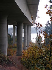
Interstate 205 is a loop route that serves the Portland
—Vancouver
metropolitan area in the U.S. states of Oregon
and Washington. I-205 is officially named the War Veterans Memorial Freeway, and is also known as the East Portland Freeway. I-205 passes east of downtown Portland and Vancouver, thus serving as a bypass route of I-5
, which runs directly through the downtown areas of both cities. The northern terminus of the highway is located north of Vancouver in the suburb of Salmon Creek
, and the southern terminus is in the Portland suburb of Tualatin
.
 I-205 starts in Tualatin, Oregon, at a directional T interchange with I-5. From I-5, the highway heads east towards the towns of West Linn
and Oregon City
where it crosses the Willamette River
between interchanges for Oregon Route 43 (OR 43) and OR 99E. In West Linn, there is a view point exit for the northbound lanes, providing a scenic overlook of Willamette Falls
. In Oregon City, the highway curves northward, crossing the Clackamas River
concurrent with OR 213 and entering the town of Gladstone
.
OR 213 splits from I-205 again at exit 13 in Clackamas
, and the next exit north on I-205 provides access to Sunnyside Road and Clackamas Town Center
. North of Clackamas, the freeway crosses the Portland city limits, passing through the eastern portion of the city, where it intersects I-84
and U.S. Route 26
(US 26). On the northern side of the city, just before crossing the Columbia River
on the Glenn Jackson Bridge, I-205 has an exit for Airport Way, which provides access to Portland International Airport
.
On the Washington side of the river, I-205 serves the eastern parts of the city of Vancouver, and has interchanges with two freeways, State Route 14
(SR 14) just north of the Columbia, and SR 500 near Westfield Vancouver
. From the SR 500 interchange, I-205 curves northwest back towards I-5, where it ends in the town of Salmon Creek
. This interchange with I-5 is not complete, as there is no direct access from I-5 northbound to I-205 southbound, or from I-205 northbound to I-5 southbound. These missing movements are completed via Northeast 134th Street, one exit to the south.
A bicycle and pedestrian trail
follows I-205 for much of its distance in the Portland metropolitan area
, and connects to the Springwater Corridor
trail near the Foster Road exit.
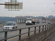 The final section of I-205 to be completed, the section between SE Division Street and the southern interchange of the Glenn Jackson Bridge
over the Columbia River, opened to traffic in March 1983. The approximately 10 miles (16.1 km) section on the Washington side of the river had opened in summer 1982, and the bridge opened in December 1982.
Construction of I-205 included a graded but unfinished transitway
between SE Foster Road and NE Columbia Boulevard. The section between NE Columbia Boulevard and the I-205/I-84 junction became part of the MAX Red Line
, and the section from E Burnside Street to SE Foster Road is used as part of the Green Line
. The short portion between these sections was used by the first rail line, now the Blue Line
.
and the suburb of Vancouver
, the Washington and Oregon
departments of transportation (WSDOT, ODOT) are currently planning improvements on I-205 to improve traffic flow between the two states. In Vancouver, WSDOT and Clark County's
Regional Transportation Commission are planning several new ramps to new arterials, grade-separating existing ramps with new ramps, and additional lanes. In Portland, ODOT is beginning to plan improvements, but no details have been released yet.
Another solution being floated around is a light rail line serving most or all the entire I-205 corridor, though the plan is being met with opposition from Clark County residents. Additionally, statements have been made by the Columbia River Crossing group that the Glenn Jackson Bridge was not properly engineered to carry light rail.
Portland, Oregon
Portland is a city located in the Pacific Northwest, near the confluence of the Willamette and Columbia rivers in the U.S. state of Oregon. As of the 2010 Census, it had a population of 583,776, making it the 29th most populous city in the United States...
—Vancouver
Vancouver, Washington
Vancouver is a city on the north bank of the Columbia River in the U.S. state of Washington. Incorporated in 1857, it is the fourth largest city in the state with a 2010 census population of 161,791 as of April 1, 2010...
metropolitan area in the U.S. states of Oregon
Oregon
Oregon is a state in the Pacific Northwest region of the United States. It is located on the Pacific coast, with Washington to the north, California to the south, Nevada on the southeast and Idaho to the east. The Columbia and Snake rivers delineate much of Oregon's northern and eastern...
and Washington. I-205 is officially named the War Veterans Memorial Freeway, and is also known as the East Portland Freeway. I-205 passes east of downtown Portland and Vancouver, thus serving as a bypass route of I-5
Interstate 5
Interstate 5 is the main Interstate Highway on the West Coast of the United States, running largely parallel to the Pacific Ocean coastline from Canada to Mexico . It serves some of the largest cities on the U.S...
, which runs directly through the downtown areas of both cities. The northern terminus of the highway is located north of Vancouver in the suburb of Salmon Creek
Salmon Creek, Washington
Salmon Creek is a census-designated place in Clark County, Washington, United States. The population was 16,767 at the 2000 census.-Geography:Salmon Creek is located at ....
, and the southern terminus is in the Portland suburb of Tualatin
Tualatin, Oregon
Tualatin is a city located primarily in Washington County in the U.S. state of Oregon. A small portion of the city is also located in neighboring Clackamas County. It is a southwestern suburb in the Portland Metropolitan Area that is located south of Tigard...
.
Route description
West Linn, Oregon
West Linn is a city in Clackamas County, Oregon, United States. Now a prosperous southern suburb of Portland, West Linn has a history of early development, prompted by the opportunity to harvest energy from nearby Willamette Falls. It was named after Senator Dr. Lewis Fields Linn of Ste...
and Oregon City
Oregon City, Oregon
Oregon City was the first city in the United States west of the Rocky Mountains to be incorporated. It is the county seat of Clackamas County, Oregon...
where it crosses the Willamette River
Willamette River
The Willamette River is a major tributary of the Columbia River, accounting for 12 to 15 percent of the Columbia's flow. The Willamette's main stem is long, lying entirely in northwestern Oregon in the United States...
between interchanges for Oregon Route 43 (OR 43) and OR 99E. In West Linn, there is a view point exit for the northbound lanes, providing a scenic overlook of Willamette Falls
Willamette Falls
The Willamette Falls is a natural waterfall on the Willamette River between Oregon City and West Linn, Oregon, in the United States. It is the largest waterfall in the Pacific Northwest and the eighteenth largest in the world by water volume. Horseshoe in shape, it is wide and high with a flow...
. In Oregon City, the highway curves northward, crossing the Clackamas River
Clackamas River
The Clackamas River is an approximately tributary of the Willamette River in northwestern Oregon, in the United States. As it drains an area of about , the Clackamas passes through mostly forested and rugged mountainous terrain in its upper reaches, and passes through agricultural and urban areas...
concurrent with OR 213 and entering the town of Gladstone
Gladstone, Oregon
Gladstone is a city located in Clackamas County, Oregon, United States. As of the 2000 census, the city had a total population of 11,438. The 2007 estimate is 12,200 residents. Gladstone is a four-square-mile suburban community twelve miles south of Portland at the confluence of the Clackamas and...
.
OR 213 splits from I-205 again at exit 13 in Clackamas
Clackamas, Oregon
Clackamas was a census-designated place in Clackamas County, Oregon, United States. The population was 5,177 at the 2000 census. It is a suburb of Portland, Oregon.It is the location of Camp Withycombe, a military base...
, and the next exit north on I-205 provides access to Sunnyside Road and Clackamas Town Center
Clackamas Town Center
Clackamas Town Center is a shopping mall in Clackamas, Oregon . It opened in 1981. It is managed and co-owned by General Growth Properties and is currently anchored by J.C. Penney, Macy's , Nordstrom, and Sears...
. North of Clackamas, the freeway crosses the Portland city limits, passing through the eastern portion of the city, where it intersects I-84
Interstate 84 in Oregon
In the U.S. state of Oregon, Interstate 84 travels east–west, following the Columbia River and the rough path of the old Oregon Trail from Portland east to Idaho. For this reason, it is also known as most of the Columbia River Highway No. 2 and all of the Old Oregon Trail Highway No. 6 . It...
and U.S. Route 26
U.S. Route 26 in Oregon
In the U.S. state of Oregon, U.S. Route 26 is a major cross-state state highway, connecting U.S. Route 101 on the Oregon Coast near Seaside with the Idaho state line east of Nyssa. Local highway names include the Sunset Highway No. 47, Mount Hood Highway No. 26, and John Day Highway No...
(US 26). On the northern side of the city, just before crossing the Columbia River
Columbia River
The Columbia River is the largest river in the Pacific Northwest region of North America. The river rises in the Rocky Mountains of British Columbia, Canada, flows northwest and then south into the U.S. state of Washington, then turns west to form most of the border between Washington and the state...
on the Glenn Jackson Bridge, I-205 has an exit for Airport Way, which provides access to Portland International Airport
Portland International Airport
Portland International Airport is a joint civil-military airport and the largest airport in the U.S. state of Oregon, accounting for 90% of passenger travel and more than 95% of air cargo of the state. It is located within Portland's city limits just south of the Columbia River in Multnomah...
.
On the Washington side of the river, I-205 serves the eastern parts of the city of Vancouver, and has interchanges with two freeways, State Route 14
State Route 14 (Washington)
State Route 14, also called the Lewis and Clark Highway, is a state highway in Washington. It extends for approximately from a junction with Interstate 5 in Vancouver in the west, to a junction with Interstate 82 and U.S...
(SR 14) just north of the Columbia, and SR 500 near Westfield Vancouver
Westfield Vancouver
Westfield Vancouver, formerly known as Vancouver Mall, is a shopping mall owned by Westfield Group, and is located in Vancouver, Washington. It is anchored by JCPenney, Macy's, Nordstrom and Sears.-History:...
. From the SR 500 interchange, I-205 curves northwest back towards I-5, where it ends in the town of Salmon Creek
Salmon Creek, Washington
Salmon Creek is a census-designated place in Clark County, Washington, United States. The population was 16,767 at the 2000 census.-Geography:Salmon Creek is located at ....
. This interchange with I-5 is not complete, as there is no direct access from I-5 northbound to I-205 southbound, or from I-205 northbound to I-5 southbound. These missing movements are completed via Northeast 134th Street, one exit to the south.
A bicycle and pedestrian trail
I-205 Bike Path
The I-205 Bike Path is a bicycle and pedestrian trail running along Interstate 205 from Vancouver, Washington to Oregon City, Oregon, United States. It parallels the highway and the I-205 Transitway. It has a paved surface...
follows I-205 for much of its distance in the Portland metropolitan area
Portland metropolitan area
The Portland-Vancouver-Hillsboro, OR-WA Metropolitan Statistical Area , also known as the Portland metropolitan area or Greater Portland, is an urban area in the U.S. states of Oregon and Washington centered around the city of Portland, Oregon. The U.S...
, and connects to the Springwater Corridor
Springwater Corridor
The Springwater Corridor Trail is a bicycle and pedestrian rail trail in the Portland metropolitan area in Oregon, United States. It follows a former railway line of the same name in its route from Boring, through Gresham, to Portland, where it ends near the Eastbank Esplanade. A large segment...
trail near the Foster Road exit.
History
Glenn L. Jackson Memorial Bridge
The Glenn L. Jackson Memorial Bridge, or I-205 bridge, is a segmental bridge that spans the Columbia River between Vancouver, Washington and Portland, Oregon....
over the Columbia River, opened to traffic in March 1983. The approximately 10 miles (16.1 km) section on the Washington side of the river had opened in summer 1982, and the bridge opened in December 1982.
Construction of I-205 included a graded but unfinished transitway
I-205 Transitway
The I-205 Transitway was a partially built busway along the wide right-of-way of the Interstate 205 freeway in Portland, Oregon. Although it never opened as a busway, its right-of-way is now in use by light rail lines....
between SE Foster Road and NE Columbia Boulevard. The section between NE Columbia Boulevard and the I-205/I-84 junction became part of the MAX Red Line
MAX Red Line
The MAX Red Line is a route in the Metropolitan Area Express light rail system in the Portland, Oregon metropolitan area. It is 25.5 miles long...
, and the section from E Burnside Street to SE Foster Road is used as part of the Green Line
MAX Green Line
The MAX Green Line is a light rail route in the MAX Light Rail system in Portland, Oregon, United States, extending to Clackamas, Oregon. Construction began in early 2007, and the line opened on September 12, 2009. The average daily ridership in June 2010 was 19,500 increasing to 23,200 by April...
. The short portion between these sections was used by the first rail line, now the Blue Line
MAX Blue Line
The MAX Blue Line is a 33 mile light rail line in the MAX Light Rail system in the Portland metropolitan area in the U.S. state of Oregon. Operated by TriMet, the line runs between Hillsboro and Gresham, via downtown Portland...
.
Future
Because of tremendous growth in the Portland metropolitan areaPortland metropolitan area
The Portland-Vancouver-Hillsboro, OR-WA Metropolitan Statistical Area , also known as the Portland metropolitan area or Greater Portland, is an urban area in the U.S. states of Oregon and Washington centered around the city of Portland, Oregon. The U.S...
and the suburb of Vancouver
Vancouver, Washington
Vancouver is a city on the north bank of the Columbia River in the U.S. state of Washington. Incorporated in 1857, it is the fourth largest city in the state with a 2010 census population of 161,791 as of April 1, 2010...
, the Washington and Oregon
Oregon Department of Transportation
The Oregon Department of Transportation is a department of the state government of the U.S. state of Oregon responsible for systems of transportation. It was first established in 1969. It had been preceded by the Oregon State Highway Department which, along with the Oregon State Highway...
departments of transportation (WSDOT, ODOT) are currently planning improvements on I-205 to improve traffic flow between the two states. In Vancouver, WSDOT and Clark County's
Clark County, Washington
Clark County is a county located in the southwestern part of the U.S. state of Washington, across the Columbia River from Portland, Oregon.Clark County was the first county of Washington, named after William Clark of the Lewis and Clark Expedition...
Regional Transportation Commission are planning several new ramps to new arterials, grade-separating existing ramps with new ramps, and additional lanes. In Portland, ODOT is beginning to plan improvements, but no details have been released yet.
Another solution being floated around is a light rail line serving most or all the entire I-205 corridor, though the plan is being met with opposition from Clark County residents. Additionally, statements have been made by the Columbia River Crossing group that the Glenn Jackson Bridge was not properly engineered to carry light rail.