
Interstate 85 in Virginia
Encyclopedia
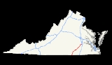
Interstate 85 is a part of the Interstate Highway System
that runs from Montgomery, Alabama
to Petersburg, Virginia
. In Virginia
, the Interstate Highway runs 68.64 miles (110.5 km) from the North Carolina
state line near Bracey
north to I-95
in Petersburg. I-85 passes through the eastern part of Southside Virginia, where it parallels U.S. Route 1
(US 1) from Petersburg, where the highway runs concurrently
with US 460
, to south of South Hill
, where the highway intersects Southside's major east–west highway, US 58
. The Interstate Highway is the primary connection between the Richmond
–Petersburg metropolitan area and the Research Triangle and other major metropolitan areas of North Carolina. Like all mainline Interstate Highways, I-85 is a part of the National Highway System
for its entire length in Virginia.
southwest of Bracey. The Interstate Highway continues southwest toward Henderson
and Durham
. Northbound I-85 has a welcome center before the highway crosses Lake Gaston, an impoundment of the Roanoke River, on a causeway and bridge before reaching an interchange with SR 903 at Bracey. The freeway passes through the town of South Hill, where the highway has a cloverleaf interchange
with US 58 (Atlantic Avenue). US 58 serves as the major east–west highway of Southside Virginia; the U.S. Highway provides access to La Crosse
, Brodnax
, Lawrenceville
, and Emporia
to the east and Boydton
and Clarksville
to the west. US 58 leads to SR 47
, which provides access to Chase City
. North of the town of South Hill, I-85 has a junction with US 1 (Mecklenburg Avenue), which parallels the Interstate Highway from Henderson to Petersburg. The US 1 interchange also provides access to SR 138
, which heads north toward Kenbridge
.
North of US 1, I-85 enters Brunswick County
just before the highway crosses the Meherrin River
. The Interstate Highway has an interchange with SR 644 (Brunswick Drive) at Meredithville
and a partial interchange with SR 46
(Christanna Highway) before the freeway crosses to the east side of US 1 (Boydton Plank Road) at an interchange southwest of the town of Alberta
. The SR 46 and US 1 interchanges provide access to St. Paul's College in Lawrenceville and the Christanna campus of Southside Virginia Community College
at the SR 46–US 1 intersection. Northeast of Alberta, I-85 has rest areas in both directions and interchanges with SR 630 (Sturgeon Road) at Sturgeonville
and SR 712 (Old Stage Road) near Rawlings
.
I-85 crosses the Nottoway River
into Dinwiddie County
southwest of its interchanges with SR 40
(McKenney Highway) near the town of McKenney
and SR 650 (Hamilton Arms Road) at DeWitt
. The Interstate Highway serves Dinwiddie
via its partial cloverleaf interchange with SR 703 (Carson Road) just east of the county seat
of Dinwiddie County and another pair of rest areas. The Dinwiddie interchange and the following interchange with US 460 (Cox Road) provide access to Virginia Motorsports Park
. At the partial cloverleaf interchange with US 460, which also leads to Dinwiddie County Airport, the Interstate Highway and U.S. Highway start to run concurrently toward Petersburg. Both the US 460 interchange and the following partial cloverleaf junction with US 1 (Boydton Plank Road) provide access to the National Museum of the Civil War Soldier at Pamplin Historical Park. East of US 1, the freeway curves to the east and changes from having a wide, forested median to a Jersey barrier
separating the twin carriageways.
I-85 enters the city of Petersburg prior to its junction with Squirrel Level Road. South of downtown Petersburg, I-85 reaches its northern terminus at a trumpet interchange with I-95. The southern end of the interchange has a ramp from northbound I-85 to southbound I-95. Here, US 460 joins I-95 south through an interchange with US 301
(Crater Road), south of which the U.S. Highway separates from I-95 on its way to Norfolk
. I-85 curves north and merges with I-95 (Richmond–Petersburg Turnpike) in the direction of Richmond adjacent to the loop ramp from northbound I-95 to southbound I-85. Just before merging with northbound I-95, I-85 has its final exit, a ramp that leads to the one-way pair
of eastbound Wythe Street and westbound Washington Street in Historic Old Towne Petersburg. Wythe Street leads to Petersburg National Battlefield
; Fort Lee, which contains the Army Quartermaster Museum
and Army Women's Museum; and the city of Hopewell
via SR 36
.
!County
!Location
!Mile
!Exit
!Destinations
!Notes
|-
|rowspan=4|Mecklenburg
|
|0.00
|
|
|Southern terminus of I-85 in Virginia; North Carolina
state line
|-
|Bracey
|4.23
|4
|
|
|-
|rowspan=2|South Hill
|12.62
|12
|
|Split into exits 12A (east) and 12B (west)
|-
|15.34
|15
|
|
|-19.37
|rowspan=5|Brunswick
|Meredithville
|24.08
|24
|
|
|-
|rowspan=2|Alberta
|style="background:#ffdddd"|27.09
|style="background:#ffdddd"|27
|style="background:#ffdddd"|
|style="background:#ffdddd"|Northbound exit, southbound entrance
|-
|28.28
|28
|
|
|-
|Sturgeonville
|34.67
|34
|
|
|-
|Rawlings
|39.38
|39
|
|
|-40.14
|rowspan=5|Dinwiddie
|McKenney
|42.52
|42
|
|
|-
|DeWitt
|48.47
|48
|
|
|-
|Dinwiddie
|53.35
|53
|
|
|-
|rowspan=2|
|style="background:#ddffdd"|61.87
|style="background:#ddffdd"|61
|style="background:#ddffdd"|
|style="background:#ddffdd"|West end of concurrency with US 460
|-
|63.64
|63
|
|Split into exits 63A (south) and 63B (north)
|-
|rowspan=4 colspan=2|City of Petersburg
|65.83
|65
|Squirrel Level Road
|
|-
|style="background:#ddffdd"|68.40
|style="background:#ddffdd"|68
|style="background:#ddffdd"|
|style="background:#ddffdd"|Northbound exit, southbound entrance; east end of concurrency with US 460
|-
|style="background:#ffdddd"|
|style="background:#ffdddd"|69
|style="background:#ffdddd"|Wythe Street east / Washington Street west – Historic Old Towne Petersburg
|style="background:#ffdddd"|Northbound exit, southbound entrance
|-
|style="background:#ffdddd"|
|style="background:#ffdddd"|
|style="background:#ffdddd"|
|style="background:#ffdddd"|Northern terminus of I-85; I-95 Exit 51; Southbound exit from and northbound entrance to I-95
|-
Interstate Highway System
The Dwight D. Eisenhower National System of Interstate and Defense Highways, , is a network of limited-access roads including freeways, highways, and expressways forming part of the National Highway System of the United States of America...
that runs from Montgomery, Alabama
Montgomery, Alabama
Montgomery is the capital of the U.S. state of Alabama, and is the county seat of Montgomery County. It is located on the Alabama River southeast of the center of the state, in the Gulf Coastal Plain. As of the 2010 census, Montgomery had a population of 205,764 making it the second-largest city...
to Petersburg, Virginia
Petersburg, Virginia
Petersburg is an independent city in Virginia, United States located on the Appomattox River and south of the state capital city of Richmond. The city's population was 32,420 as of 2010, predominantly of African-American ethnicity...
. In Virginia
Virginia
The Commonwealth of Virginia , is a U.S. state on the Atlantic Coast of the Southern United States. Virginia is nicknamed the "Old Dominion" and sometimes the "Mother of Presidents" after the eight U.S. presidents born there...
, the Interstate Highway runs 68.64 miles (110.5 km) from the North Carolina
North Carolina
North Carolina is a state located in the southeastern United States. The state borders South Carolina and Georgia to the south, Tennessee to the west and Virginia to the north. North Carolina contains 100 counties. Its capital is Raleigh, and its largest city is Charlotte...
state line near Bracey
Bracey, Virginia
Bracey is a census-designated place in Mecklenburg County, Virginia, United States. It is located next to South Hill, La Crosse, and Broadnax also in Mecklenburg County. The CDP had an estimated population of 1,554 in 2010.-Geography and climate:...
north to I-95
Interstate 95 in Virginia
In the Commonwealth of Virginia, Interstate 95 runs through the state. It runs concurrently for with Interstate 64 in Richmond, and meets the northern terminus of Interstate 85 in Petersburg. Though Interstate 95 was originally planned to go straight through Washington, D.C., it was instead...
in Petersburg. I-85 passes through the eastern part of Southside Virginia, where it parallels U.S. Route 1
U.S. Route 1 in Virginia
U.S. Route 1 in the U.S. state of Virginia runs north–south through South Hill, Petersburg, Richmond, Fredericksburg, and Alexandria on its way from North Carolina to the 14th Street Bridge into the District of Columbia...
(US 1) from Petersburg, where the highway runs concurrently
Concurrency (road)
A concurrency, overlap, or coincidence in a road network is an instance of one physical road bearing two or more different highway, motorway, or other route numbers...
with US 460
U.S. Route 460 in Virginia
U.S. Route 460 in Virginia runs east–west through the southern part of the state. It has two separate pieces in Virginia, joined by a relatively short section in West Virginia...
, to south of South Hill
South Hill, Virginia
South Hill is a town in Mecklenburg County, Virginia, United States. As of the 2006 census, the town population was 4,608. Located on major Interstate and U.S. highways, it has a full service hospital , a tobacco market, and several hotels. South Hill has a close relationship with the neighboring...
, where the highway intersects Southside's major east–west highway, US 58
U.S. Route 58
U.S. Route 58 is an east–west U.S. Highway that runs for from U.S. Route 25E just northwest of Harrogate, Tennessee to U.S. Route 60 in Virginia Beach, Virginia. Until 1996, when the Cumberland Gap Tunnel opened, US 58 ran only inside the commonwealth of Virginia...
. The Interstate Highway is the primary connection between the Richmond
Richmond, Virginia
Richmond is the capital of the Commonwealth of Virginia, in the United States. It is an independent city and not part of any county. Richmond is the center of the Richmond Metropolitan Statistical Area and the Greater Richmond area...
–Petersburg metropolitan area and the Research Triangle and other major metropolitan areas of North Carolina. Like all mainline Interstate Highways, I-85 is a part of the National Highway System
National Highway System (United States)
The National Highway System is a network of strategic highways within the United States, including the Interstate Highway System and other roads serving major airports, ports, rail or truck terminals, railway stations, pipeline terminals and other strategic transport facilities.Individual states...
for its entire length in Virginia.
Route description
I-85 enters Virginia in Mecklenburg CountyMecklenburg County, Virginia
As of the census of 2010, there were 32,727 people, 12,951 households, and 8,962 families residing in the county. The population density was 52 people per square mile . There were 17,403 housing units at an average density of 28 per square mile...
southwest of Bracey. The Interstate Highway continues southwest toward Henderson
Henderson, North Carolina
Henderson, with a population of 16,095 at the 2000 census, is the county seat of Vance County, North Carolina, United States.The city was named in honor of former North Carolina Supreme Court Chief Justice Leonard Henderson, who lived nearby and was a friend of early settler Lewis Reavis...
and Durham
Durham, North Carolina
Durham is a city in the U.S. state of North Carolina. It is the county seat of Durham County and also extends into Wake County. It is the fifth-largest city in the state, and the 85th-largest in the United States by population, with 228,330 residents as of the 2010 United States census...
. Northbound I-85 has a welcome center before the highway crosses Lake Gaston, an impoundment of the Roanoke River, on a causeway and bridge before reaching an interchange with SR 903 at Bracey. The freeway passes through the town of South Hill, where the highway has a cloverleaf interchange
Cloverleaf interchange
A cloverleaf interchange is a two-level interchange in which left turns, reverse direction in left-driving regions, are handled by ramp roads...
with US 58 (Atlantic Avenue). US 58 serves as the major east–west highway of Southside Virginia; the U.S. Highway provides access to La Crosse
La Crosse, Virginia
La Crosse is a town in Mecklenburg County, Virginia, United States. Its name is derived from the fact that it was a place where railroads once crossed, and there is still a caboose in the center of the town...
, Brodnax
Brodnax, Virginia
Brodnax is a town in Brunswick and Mecklenburg counties in the U.S. state of Virginia. The population was 317 at the 2000 census.-Geography:Brodnax is located at ....
, Lawrenceville
Lawrenceville, Virginia
Lawrenceville is a town in Brunswick County, Virginia, United States. The population was 1,275 at the 2000 census. Located by the Meherrin River, it is the county seat of Brunswick County and home to historically black Saint Paul's College, founded in 1888 and affiliated with the Episcopal Church...
, and Emporia
Emporia, Virginia
Emporia is an independent city located within the confines of Greensville County, Virginia, United States. The population was estimated to be 5,927 in 2010. The Bureau of Economic Analysis combines the city of Emporia with surrounding Greensville county for statistical purposes...
to the east and Boydton
Boydton, Virginia
Boydton is a town in Mecklenburg County, Virginia, United States. The population was 454 at the 2000 census. It is the county seat of Mecklenburg County, and it is near the Mecklenburg Correctional Center.-Geography:...
and Clarksville
Clarksville, Virginia
Clarksville is a town founded in Mecklenburg County and overlapping across Halifax County in the U.S. state of Virginia, near the southern border of the state. The population was 1,139 at the 2010 census...
to the west. US 58 leads to SR 47
Virginia State Route 47
Virginia State Route 47 is a primary state highway in the U.S. state of Virginia. The state highway runs from U.S. Route 1 and US 58 Business in South Hill north to US 460 Business in Pamplin City, Virginia...
, which provides access to Chase City
Chase City, Virginia
Chase City is a town in Mecklenburg County, Virginia, United States. The population was 2,457 at the 2000 census. Tobacco and other crops are grown nearby...
. North of the town of South Hill, I-85 has a junction with US 1 (Mecklenburg Avenue), which parallels the Interstate Highway from Henderson to Petersburg. The US 1 interchange also provides access to SR 138
Virginia State Route 138
Virginia State Route 138 is a primary state highway in the U.S. state of Virginia. The state highway runs from U.S. Route 1 in South Hill north to SR 40 in Kenbridge...
, which heads north toward Kenbridge
Kenbridge, Virginia
Kenbridge is a town in Lunenburg County, Virginia, United States. The population was 1,253 at the 2000 census. It is in a tobacco farming area. The area is home to noted folk artist Eldridge Bagley.-Geography:Kenbridge is located at ....
.
North of US 1, I-85 enters Brunswick County
Brunswick County, Virginia
As of the census of 2000, there were 18,419 people, 6,277 households, and 4,312 families residing in the county. The population density was 32 people per square mile . There were 7,541 housing units at an average density of 13 per square mile...
just before the highway crosses the Meherrin River
Meherrin River
The Meherrin River is a long river in the U.S. states of Virginia and North Carolina. It begins in central Virginia, about northwest of Emporia, and flows roughly east-southeast into North Carolina, where it joins the larger Chowan River....
. The Interstate Highway has an interchange with SR 644 (Brunswick Drive) at Meredithville
Meredithville, Virginia
Meredithville is an unincorporated community located in Brunswick County, in the U.S. state of Virginia.-Reference:...
and a partial interchange with SR 46
Virginia State Route 46
Virginia State Route 46 is a primary state highway in the U.S. state of Virginia. The state highway begins at the North Carolina state line near Valentines, where the highway continues as North Carolina Highway 46 . SR 46 runs north from the state line to SR 40 in Blackstone...
(Christanna Highway) before the freeway crosses to the east side of US 1 (Boydton Plank Road) at an interchange southwest of the town of Alberta
Alberta, Virginia
Alberta is a town in Brunswick County, Virginia, United States. The population was 306 at the 2000 census. It is home to the Christanna Campus of Southside Virginia Community College.-Geography:...
. The SR 46 and US 1 interchanges provide access to St. Paul's College in Lawrenceville and the Christanna campus of Southside Virginia Community College
Southside Virginia Community College
Southside Virginia Community College is one of the 23 schools in the Virginia Community College System. It was founded in 1970 and has the largest geographic service area of any community college in the state, covering 10 counties and the city of Emporia....
at the SR 46–US 1 intersection. Northeast of Alberta, I-85 has rest areas in both directions and interchanges with SR 630 (Sturgeon Road) at Sturgeonville
Sturgeonville, Virginia
Sturgeonville is an unincorporated community located in Brunswick County, in the U.S. state of Virginia.-Reference:...
and SR 712 (Old Stage Road) near Rawlings
Rawlings, Virginia
Rawlings is an unincorporated community located in Brunswick County, in the U.S. state of Virginia.-Reference:...
.
I-85 crosses the Nottoway River
Nottoway River
The Nottoway River is in southern Virginia and northeastern North Carolina. It is part of the Chowan River system, which flows into Albemarle Sound in North Carolina.-Cities and towns:Cities and towns along the river include:* Courtland, Virginia...
into Dinwiddie County
Dinwiddie County, Virginia
Dinwiddie County is a county located in the Commonwealth of Virginia. As of 2010, the population was 28,001. Its county seat is Dinwiddie.- History :...
southwest of its interchanges with SR 40
Virginia State Route 40
State Route 40 is a primary state highway in the southern part of the U.S. state of Virginia. It runs from State Route 8 at Woolwine east to State Route 10 at Spring Grove, about half the width of Virginia. It is the longest state-numbered route in Virginia.-Route description:SR 40 begins at SR 8...
(McKenney Highway) near the town of McKenney
McKenney, Virginia
McKenney is a small southern historic town in Dinwiddie County, Virginia, United States. The population was 483 at the 2010 census.-Geography:McKenney is located at ....
and SR 650 (Hamilton Arms Road) at DeWitt
DeWitt, Virginia
DeWitt is an unincorporated community in Dinwiddie County, Virginia, United States. DeWitt is located on U.S. Route 1 northeast of McKenney....
. The Interstate Highway serves Dinwiddie
Dinwiddie, Virginia
Dinwiddie is a small unincorporated community in and the county seat of Dinwiddie County, Virginia, United States. The town was the site of the Battle of Dinwiddie Court House, the Battle of Five Forks as well as the Battle of Sutherland's Station during the Appomattox Campaign.The town is near the...
via its partial cloverleaf interchange with SR 703 (Carson Road) just east of the county seat
County seat
A county seat is an administrative center, or seat of government, for a county or civil parish. The term is primarily used in the United States....
of Dinwiddie County and another pair of rest areas. The Dinwiddie interchange and the following interchange with US 460 (Cox Road) provide access to Virginia Motorsports Park
Virginia Motorsports Park
Virginia Motorsports Park is a quarter-mile dragstrip in Dinwiddie County, Virginia, just outside Petersburg. It opened in 1994 and hosted the NHRA's Torco Racing Fuels NHRA Nationals. It has a seating capacity of 23,000 spectators. The track has recently returned to the IHRA.-External links:*...
. At the partial cloverleaf interchange with US 460, which also leads to Dinwiddie County Airport, the Interstate Highway and U.S. Highway start to run concurrently toward Petersburg. Both the US 460 interchange and the following partial cloverleaf junction with US 1 (Boydton Plank Road) provide access to the National Museum of the Civil War Soldier at Pamplin Historical Park. East of US 1, the freeway curves to the east and changes from having a wide, forested median to a Jersey barrier
Jersey barrier
A Jersey barrier or Jersey wall is a modular concrete barrier employed to separate lanes of traffic. It is designed to both minimize vehicle damage in cases of incidental contact while still preventing crossover in the case of head-on accidents....
separating the twin carriageways.
I-85 enters the city of Petersburg prior to its junction with Squirrel Level Road. South of downtown Petersburg, I-85 reaches its northern terminus at a trumpet interchange with I-95. The southern end of the interchange has a ramp from northbound I-85 to southbound I-95. Here, US 460 joins I-95 south through an interchange with US 301
U.S. Route 301 in Virginia
U.S. Route 301 is a part of the U.S. Highway System that runs from Sarasota, Florida to Glasgow, Delaware. In Virginia, the U.S. Highway runs from the North Carolina state line near Skippers north to the Maryland state line at the Potomac River near Dahlgren. US 301 forms the local complement...
(Crater Road), south of which the U.S. Highway separates from I-95 on its way to Norfolk
Norfolk, Virginia
Norfolk is an independent city in the Commonwealth of Virginia in the United States. With a population of 242,803 as of the 2010 Census, it is Virginia's second-largest city behind neighboring Virginia Beach....
. I-85 curves north and merges with I-95 (Richmond–Petersburg Turnpike) in the direction of Richmond adjacent to the loop ramp from northbound I-95 to southbound I-85. Just before merging with northbound I-95, I-85 has its final exit, a ramp that leads to the one-way pair
One-way pair
A one-way pair, one-way couple, or just couplet is a pair of parallel, usually one-way streets that carry opposite directions of a signed route or major traffic flow, or sometimes opposite directions of a bus or streetcar route....
of eastbound Wythe Street and westbound Washington Street in Historic Old Towne Petersburg. Wythe Street leads to Petersburg National Battlefield
Petersburg National Battlefield
Petersburg National Battlefield is a National Park Service unit preserving sites related to the American Civil War Siege of Petersburg. The Battlefield is centered around Petersburg, Virginia, and also includes outlying components in Hopewell, Prince George County, and Dinwiddie County...
; Fort Lee, which contains the Army Quartermaster Museum
Army Quartermaster Museum
The United States Army Quartermaster Museum, located at Fort Lee, Virginia, is one of a number of small museums in the Commonwealth of Virginia. The museum's aim is to preserve and exhibit the history of the Quartermaster Corps, which was formed in 1775 and to date it has collected more than 20,000...
and Army Women's Museum; and the city of Hopewell
Hopewell, Virginia
Hopewell is an independent city in the Commonwealth of Virginia. The population was 22,591 at the 2010 Census . It is in Tri-Cities area of the Richmond-Petersburg region and is a portion of the Richmond Metropolitan Statistical Area...
via SR 36
Virginia State Route 36
Virginia State Route 36 is a state highway in the U.S. state of Virginia. The state highway runs from SR 602 and SR 669 near Matoaca east to SR 10 in Hopewell. SR 36 is the main highway between Petersburg and Hopewell; within each independent city, the state highway follows a byzantine path...
.
Exit list
{| class=wikitable!County
!Location
!Mile
!Exit
!Destinations
!Notes
|-
|rowspan=4|Mecklenburg
Mecklenburg County, Virginia
As of the census of 2010, there were 32,727 people, 12,951 households, and 8,962 families residing in the county. The population density was 52 people per square mile . There were 17,403 housing units at an average density of 28 per square mile...
|
|0.00
|
|
|Southern terminus of I-85 in Virginia; North Carolina
North Carolina
North Carolina is a state located in the southeastern United States. The state borders South Carolina and Georgia to the south, Tennessee to the west and Virginia to the north. North Carolina contains 100 counties. Its capital is Raleigh, and its largest city is Charlotte...
state line
|-
|Bracey
Bracey, Virginia
Bracey is a census-designated place in Mecklenburg County, Virginia, United States. It is located next to South Hill, La Crosse, and Broadnax also in Mecklenburg County. The CDP had an estimated population of 1,554 in 2010.-Geography and climate:...
|4.23
|4
|
|
|-
|rowspan=2|South Hill
South Hill, Virginia
South Hill is a town in Mecklenburg County, Virginia, United States. As of the 2006 census, the town population was 4,608. Located on major Interstate and U.S. highways, it has a full service hospital , a tobacco market, and several hotels. South Hill has a close relationship with the neighboring...
|12.62
|12
|
|Split into exits 12A (east) and 12B (west)
|-
|15.34
|15
|
|
|-19.37
|rowspan=5|Brunswick
Brunswick County, Virginia
As of the census of 2000, there were 18,419 people, 6,277 households, and 4,312 families residing in the county. The population density was 32 people per square mile . There were 7,541 housing units at an average density of 13 per square mile...
|Meredithville
Meredithville, Virginia
Meredithville is an unincorporated community located in Brunswick County, in the U.S. state of Virginia.-Reference:...
|24.08
|24
|
|
|-
|rowspan=2|Alberta
Alberta, Virginia
Alberta is a town in Brunswick County, Virginia, United States. The population was 306 at the 2000 census. It is home to the Christanna Campus of Southside Virginia Community College.-Geography:...
|style="background:#ffdddd"|27.09
|style="background:#ffdddd"|27
|style="background:#ffdddd"|
|style="background:#ffdddd"|Northbound exit, southbound entrance
|-
|28.28
|28
|
|
|-
|Sturgeonville
Sturgeonville, Virginia
Sturgeonville is an unincorporated community located in Brunswick County, in the U.S. state of Virginia.-Reference:...
|34.67
|34
|
|
|-
|Rawlings
Rawlings, Virginia
Rawlings is an unincorporated community located in Brunswick County, in the U.S. state of Virginia.-Reference:...
|39.38
|39
|
|
|-40.14
|rowspan=5|Dinwiddie
Dinwiddie County, Virginia
Dinwiddie County is a county located in the Commonwealth of Virginia. As of 2010, the population was 28,001. Its county seat is Dinwiddie.- History :...
|McKenney
McKenney, Virginia
McKenney is a small southern historic town in Dinwiddie County, Virginia, United States. The population was 483 at the 2010 census.-Geography:McKenney is located at ....
|42.52
|42
|
|
|-
|DeWitt
DeWitt, Virginia
DeWitt is an unincorporated community in Dinwiddie County, Virginia, United States. DeWitt is located on U.S. Route 1 northeast of McKenney....
|48.47
|48
|
|
|-
|Dinwiddie
Dinwiddie, Virginia
Dinwiddie is a small unincorporated community in and the county seat of Dinwiddie County, Virginia, United States. The town was the site of the Battle of Dinwiddie Court House, the Battle of Five Forks as well as the Battle of Sutherland's Station during the Appomattox Campaign.The town is near the...
|53.35
|53
|
|
|-
|rowspan=2|
|style="background:#ddffdd"|61.87
|style="background:#ddffdd"|61
|style="background:#ddffdd"|
|style="background:#ddffdd"|West end of concurrency with US 460
|-
|63.64
|63
|
|Split into exits 63A (south) and 63B (north)
|-
|rowspan=4 colspan=2|City of Petersburg
Petersburg, Virginia
Petersburg is an independent city in Virginia, United States located on the Appomattox River and south of the state capital city of Richmond. The city's population was 32,420 as of 2010, predominantly of African-American ethnicity...
|65.83
|65
|Squirrel Level Road
|
|-
|style="background:#ddffdd"|68.40
|style="background:#ddffdd"|68
|style="background:#ddffdd"|
|style="background:#ddffdd"|Northbound exit, southbound entrance; east end of concurrency with US 460
|-
|style="background:#ffdddd"|
|style="background:#ffdddd"|69
|style="background:#ffdddd"|Wythe Street east / Washington Street west – Historic Old Towne Petersburg
Petersburg, Virginia
Petersburg is an independent city in Virginia, United States located on the Appomattox River and south of the state capital city of Richmond. The city's population was 32,420 as of 2010, predominantly of African-American ethnicity...
|style="background:#ffdddd"|Northbound exit, southbound entrance
|-
|style="background:#ffdddd"|
|style="background:#ffdddd"|
|style="background:#ffdddd"|
|style="background:#ffdddd"|Northern terminus of I-85; I-95 Exit 51; Southbound exit from and northbound entrance to I-95
|-
External links
- Virginia Highways Project: I-85
- Roads to the Future: I-85
- Virginia at AARoads: Interstate 85 north and Interstate 85 south